allez, encore un p'tit post!
Je passe mes nuits à lire et lire toutes ces discussions, c'est vraiment une mine d'or ce forum! Merci à ceux qui l’ont lancé!
Bon, je prévois, début mars, de remonter la Thaïlande du sud au nord, jusqu’à Chang Rai, avec un vélo un peu chargé (entre autre, matos photo = 10kg)
Ne voulant ni les grands axes, ni la route qui longe la birmanie (car trop de dénivellés et trop de pistes défoncées semble t'il), il ne me reste que les petites routes + ou - en ligne droite.
Beaucoup recommande de tracer sa route sur google earth puis de la charger sur le GPS
J'y pige que dalle, connaissez vous un tutoriel pour apprendre à faire cela?
J'ai un GPS "Europe", dois je acheter une carte électronique pour l'asie du SE?
Merci merci pour vos réponses...
bruno
salut
sur ce site il y a des cartes a telecharger
j espere que tu pige l'anglais !
pour tes questions de tente
j'ai trimballé ma tente 5 fois pendant 3 mois en asie du sud est et ne l'ai prsque pas utilisée
peut etre 3 fois par voyage mais je continuerai a la prendre
bonne route
en haut a droite dans download maps
la il te demande de te faire membre puis peut etre de faire un don de quelques €
sinon sur VF le membre margouilla est une vraie tete pour tout cela
j'ai bien d'autre site avec des cartes gratuite mais je ne suis pas sur mon pc donc demain je pourrai te filer les liens
salut, en Thailande, moi je fais mes itinéraires dans les cyber-cafés (y'en a presque partout) sur Viamichelin. Cartes très détaillées. Je recopie sur papier les indications, et je photographie l'écran de l'ordi quand je pense que ça va me servir à reconnaître les lieux une fois sur place.
E, t globalement, le revêtement des routes est bon.
Mais effectivement beaucoup de dénivelés le long de la Birmanie (Myanmar aujourd'hui, tout se perd, même les noms des pays!!) et surtout des pourcentages de dingue...
Bonne route; on va se croiser, je reviens en France mi-mars, après à nouveau 3 mois dans le coin.
* sans muzik la vie serait une erreur* (Nietzsche)
bon, j'ai bien tout lu, ils veulent 50$ avant de télécharger quoi que ce soit...
En attendant j'essaie de telecharger sur piratebay les cartes garmin sans trop savoir si ça va marcher avec un Mac. J'ai installé aussi les logiciels Garmin mapinstall, mapmanager et roadtrip sur mon mac... Je pige pas grand chose mais j'ai de la patience...
Sinon si tu as d'autres plans, c'est welcome
Merci!
"Quand l'injustice devient loi, la rébellion devient devoir. " Thomas Jefferson
« Le doute est l’apanage des gens intelligents, les cons n’ont que des certitudes »
(Alain Leblay)
Bonjour,
Tu as aussi la possibilité d'acheter en arrivant en Thaïlande un smartphone tel que le Samsung galaxie avec une fonction GPS.(GT-55570, environ 6000 THB)
"Quand l'injustice devient loi, la rébellion devient devoir. " Thomas Jefferson
« Le doute est l’apanage des gens intelligents, les cons n’ont que des certitudes »
(Alain Leblay)
Merci pour ces infos... Woao, en effet, il y a du choix!
Entre temps, j'ai récupéré les cartes garmin: worldmap et southeast asia, puis egalement les cartes du site: http://garmin.openstreetmap.nl/
Je ne sais pas ce que ça vaut, je n'ai rien installé encore (ou presque)
En fait je réalise qu'il y a plein d'options et... avec une petite grippe qui s'installe, j'avoue que ça me tourne un peu la tête...
Idéalement, ce que j'aimerai bien, c'est un conseil sur un seul système de carte fiable, et après, je m'y colle, tutoriel, logiciel et tout l'toutim...
Si je comprends bien, le principe est toujours le même: tu installes un logiciel sur ton ordi, télécharge les cartes qui vont avec. Ensuite tu marques tes waypoint, ce qui constitue ta route. Une fois fini, tu download cette route dans ton GPS (moi un garmin nuvi 1340) avec les cartes associées
Jusqu'à là ça tient la route??? 🤪
Alors quel logiciel? quelle cartes? sachant que j'ai un Mac (pour faire simple...🙂 )
Salut Berber,
Connais tu ce site: http://garmin.openstreetmap.nl/
curieux de savoir si ces cartes sont fiables??? car j'ai finalement réussi a les telecharger et les ouvrir sur mon ordi. Je devrai enfin pouvoir tracer une route et la coller dans le GPS.
J'attends des feedback avant
Merci!
La couverture des cartes OSM est très aléatoire. Ce sont les particuliers (toi-moi) qui les tracent à l'aide de leurs relevés GPS ou de photos satellite.
En ce qui concerne la Thailande ça à l'air assez faible en dehors des grand axes.
Par contre Googlemaps est bien plus précis.
Pour tracer un itinéraire (et donc exporter une trace GPX pour son GPS) , je te conseille d'utiliser un planificateur de parcours en ligne.
Il y en a des 10zaines sur le web. J'utilise celui-la en dehors de la France
Tu peux mettre comme fond soit googlemap(+ relief), soit OSM (+ osm cycle) soit une photo satellite.
Tu pourras ainsi apprécier la couverture OSM par rapport à Googlemap ou par rapport à un fond réel (satellite)
salut
oui je connais mais ne l'ai jamais utilisé
as tu installé mapsource de garmin
c'est que j'utilise et avec toutes les cartes de que l'on peux telecharger ici ou la
avec mapsettoolkit et cgps mapeploreur tu peux les installer dans mapsource puis dans ton gps
Ouaip, sauf que j'ai un mac et mapsource ne marche pas sur mac. Le logiciel pour mac c'est Garmin Roadtrip. J'ai regardé sur les forums ca n'a pas l'air simple d'utilisation. Je vais faire un essai aujourd'hui
Merci pour l'info
Bike route toaster a l'air interessant, mais pardonne mon ignorance, comment fais tu pour mettre googlemap "comme fond" dans le gps? Faut il un logiciel? Compatible mac?
Ensuite je suppose que tu traces ta route sur l'ecran de l'ordi puis tu l'exportes (euh... comment t'exportes ça?) sur le gps
Ah... la la... Peut etre je vais apprendre le Thai plutot que le gps...🤪
J'ai téléchargé les cartes garmin City Navigator Southeast Asia NT 6.5 et WorldMap 4 mais pas foutu de les mettre dans le gps. Le logiciel garmin Mapinstall ne voit que dalle, (par contre il a vu les cartes de openstreetmap) le logiciel garmin Mapmanager ne reconnait pas les formats .nrg de worldmap 4 et .img de city nav SEAsia
Mais l'idée c'est de faire du VELO!
Est-ce que je galère parce que je suis sur mac?
ou parce que je suis une MULE?...😮
sos...
Trés trés chouette le bikemap.net, surtout que il y a déjà plein de routes tracées, avec choix de route pavée, ou non, et les dénivellés... Vraiment tout ce qu'il faut pour le voyage a vélo
J'ai téléchargé une route existante dans les 2 formats proposés, mais les 2 logiciels (mac) dont je dispose pour les rentrer dans le gps (mapinstall et mapmanager) ne reconnaissent pas ces formats...
Bon, patience...
Bonjour ,
il y a le site Openrunner.com qui permet aussi de tracer des parcours et de les télécharger sur GPS ! il y a aussi des parcours déjà tracés sur la thailande. Un simple inscription et le tour est joué !!
Bonne prépa !
Merci pour l'info... mais impossible de faire rentrer quoi que ce soit dans ce p..... de GPS
Comprends pas COMMENT mettre un logiciel, une trace, une carte, ... et puis la journée à passée
alors j’arrête, je resterai sur les grands axes, à moins qu'une âme généreuse ne veuille m'envoyer un tuto "précis" pour mac (et pour nul!)
Pas de bile...
Merci à tous!
le danger, c'est surtout de ne pas l'écraser sous un gros cailloux !
Figure toi qu'aprés avoir cherché TOUTE la journée, vers minuit, je suis tombé sur un tutoriel vidéo Youtube qui me montrait que mon modèle de GPS me prenais pas les routes...😠😠😠
Alors, je me suis fait un bon thé aux épices et puis je suis allé regarder les étoiles...
Je vais sans doute le prendre quand même et je verrai bien une fois sur place si il y a une carte ou bien quoi...
Quand je pense que j'ai utilisé les GPS depuis que ça existe sur les voiliers (25 ans sur la mer), je suis rentré dans des barrières de corail pil poil dans la passe "au GPS" car seul sur mon rafiot en Polynésie...
C'est quand même super cet outil, et puis l'idée de prendre les petites routes me plaisait bien. Je ne crois pas que tu peux faire ça avec ta carte papier. Trop de petites bifurcations, carrefours, route qui se divisent etc...
Enfin bon... "C'est la vie " comme disent les américains!
et puis l'idée de prendre les petites routes me plaisait bien. Je ne crois pas que tu peux faire ça avec ta carte papier. Trop de petites bifurcations, carrefours, route qui se divisent etc...
franchement, avec mon système, en Thailande (ailleurs je sais pas) tu peux prendre vraiment beaucoup de petites routes (QUI NE SONT PAS SUR TES CARTES PAPIERS). A condition de passer la veille du temps dans un cyber-café à bien préparer ton itinéraire. Et sinon, je complète avec la boussole: je sais que telle ville que je veux rejoindre est par exemple plein nord, alors aux carrefours où j'ai des doutes, ben je prends plein nord. C'est pas la certitude d'arriver au but le plus sûrement et rapidement, mais tu es sur les petites routes (ou pistes!) , tu vois du pays, et tu rencontres du monde (des locaux qui se demandent bien ce que tu fais là!). Et avec la tente dans la sacoche, où que tu sois quand la nuit tombe, ben t'es pas dehors. Et si en plus dans la dite sacoche tu as un peu de quoi manger et de l'eau, ben tu es "le roi du pétrole" (sans les problèmes de gestion d'argent que le sus mentionné roi doit avoir!)
* sans muzik la vie serait une erreur* (Nietzsche)
je suis tombé sur un tutoriel vidéo Youtube qui me montrait que mon modèle de GPS me prenais pas les routes...😠😠😠
Et si tu nous disais quel modèle de GPS tu as ? 😏
S'il est récent, il doit accepter les traces ou les routes au même format GPX. Que tu sois sur Mac ou PC, avec openrunner tu fais ton itinéraire, tu l'enregistres en .gpx et tu le copies/colles dans le dossier adéquat de ton GPS.
Si c'est un Garmin récent, le GPS "monte" sur le bureau du Mac et dans son dossier Garmin il y a un sous-dossier gpx dans lequel tu colles ton parcours. Avec un PC la manip est identique. Il faut évidemment être enregistré (gratuit) chez openrunner et descendre tout en bas de la fenêtre pour pouvoir enregistrer ton parcours.
Pour la cartographie gratuite, c'est plus délicat effectivement avec un Mac (je fais avec un vieux PC).
Pour la cartographie payante, avec un Mac récent et un GPS récent, il n'y a pas de problème.
Merci pour l'info...
Regain d'espoir?
c'est un Garmin nuvi 1340 tout neuf. J'ai déjà téléchargé des routes sur bikemap.net au format .gpx, que j'ai mis dans le sous dossier GPX trouvé dans le dossier GARMIN dans le bureau. Mais aprés, tu l'ouvres comment?
Selon un tutoriel sur Youtube, le mec dit que si tu ne trouves pas de case "route"ou cliquer sur l'écran du GPS, c'est que le gps n'accepte pas les routes.
J'ai un mac neuf et un vieux pc...
Si t'as une idée...
Non, pas vraiment... 😕Ce Garmin Nuvi (dont la technologie date de 4 ans, même s'il est tout neuf...) n'accepte pas les tracés GPX. Il n'était pas conçu pour cet usage mais uniquement fait pour la navigation voiture simple, d'un point A à un point B par le réseau routier. Il fait partie de la série Essential, modèles simples, alors que le Garmin Nuvi 2340 par exemple, plus récent, de la série Advance, accepte les itinéraires GPX (pour 30€ euros de plus...). Il faut dire que ce format universel GPX n'a été adopté par tous les fabricants que depuis peu et que les sites commerciaux ne mettent pas ce point essentiel suffisamment en avant lors du choix d'achat...
Tu as un forum (en anglais) qui traite de la question : http://forums.gpsreview.net/viewtopic.php?t=22707
Sinon, un Garmin de randonnée genre Etrex ou Oregon, ne te poserait pas de problèmes pour "bricoler" des parcours car c'est vraiment leur vocation.
Bon, merci toutefois beaucoup car tu m'apporte un element de réponse CLAIR
Dommage j'ai cru en le choisissant que ça allait marcher...
Puisque tu t'y connais, pourrais-je me permettre une autre question?
Je peux toujours l'utiliser en gps normal, c'est à dire avoir ma position non?
Et dans ce cas, j'ai à ma disposition soit la carte WORLD vendu avec le gps, soit j'achete la carte Garmin City Navigator Southeast Asia (que j'ai récupéré sur le site piratebay mais ca ne marche pas)
Alors question: crois tu que avec la carte CN Southeast Asia je verrais plus de routes secondaires ou est-ce seulement une carte interessante pour les villes (city) ou je n'irai pas?
Merci d'avance!
Je peux toujours l'utiliser en gps normal, c'est à dire avoir ma position non?
Oui bien sûr, si tu as une carte (et si possible meilleure que la carte du monde dont la marge d'erreur est de +/- 100m en France... alors en Asie....)
crois tu que avec la carte CN Southeast Asia je verrais plus de routes secondaires ou est-ce seulement une carte interessante pour les villes (city) ou je n'irai pas?
Elle est évidemment plus précise que la World mais avec prédominance logique sur les villes.
Tu devrais plutôt te tourner vers les cartes gratuites du mapcenter, bien plus détaillées pour la Thaïlande profonde : http://mapcenter.cgpsmapper.com/catalogue.php
Il y a là d'excellentes cartes de Thaïlande gratuites (172 quand même...), faites par les utilisateurs eux-mêmes, au format Garmin .img : tu télécharges la région qui t'intéresse et tu installes pour le transfert une petite application gratuite également (icône en forme d'entonnoir vert) appelée sendmap20 http://cgpsmapper.com/buy.htm
Le transfert de ces cartes ne peut se faire, à ma connaissance, qu'avec un PC (même vieux, du moment qu'il possède une connexion USB).
Résumé de la procédure (simplifiée car il y en a plusieurs possibles) :
- télécharger la carte voulue
- télécharger et installer sendmap20 sur le bureau du PC
- connecter le GPS au PC : l'ordinateur doit le reconnaître et si ce n'est pas le cas, installer le pilote Garmin USB driver (facile à trouver chez Garmin)
- glisser la carte dans l'icône "entonnoir vert" de sendmap et... le transfert se fait !
N.B. si on veut avoir plusieurs cartes Garmin en même temps dans son GPS, il faut les avoir transférées en même temps, en une seule opération ; sinon la dernière chargée écrase la précédente.
Certains utilisateurs de Nuvi ayant eu des problèmes avec le transfert par sendmap, ils préconisent d'utiliser la fonction de sendmap qui permet de créer directement un ensemble de cartes GMAPSUPP.IMG que l'on va copier ensuite manuellement dans le dossier Garmin du GPS. Et là ça marche.
Merci pour ces infos!
Bon, j'ai suivi tes instructions, j'ai enfilé plein de cartes dans l'entonnoir vert. ça n'a pas donné grand chose au début mais aprés plein de manip, je suis quand meme arrivé à voir dans le dossier MAP ("carte" en francais) du gps des autres cartes, dont celles téléchargées sur : http://garmin.openstreetmap.nl/ J'ai compris que le gps acceptait les cartes au format .img. Ensuite ce que j'ai fait, je suis allé à la peche aux cartes .img sur le site openstreetmap et mapcenter. J'ai renommé toutes les cartes pour m'y retrouver, puis je les ai simplement copié collé dans le dossier MAP. J'ai fais tout ca avec le MAC
Maintenant quand j'allume le gps et que je regarde dans les infos cartes, je vois la liste des cartes que j'ai rentré, sous l’intitulé" cGPSmapper version 0083A- this map cannot be"
Curieusement, j'ai chargé 8 cartes de malaisie dans le gps et je n'en vois que 5 sur la page "info carte"
Je ne peux pas voir la carte en elle meme car je ne suis pas encore en malaisie... alors on verra bien.
Par curiosité j'ai vidé à nouveau le dossier MAP, cette fois ci avec le vieux PC et j'ai rentré à nouveau dans l'entonnoir les 8 cartes. Mais là, rien n'a apparu dans le dossier MAP
Dans la manip j'ai perdu la carte monde de garmin... Je vais essayer de la récuperer sur le site garmin
arrrrhhhh....
Quand je pense que j'ai un etrex, mais il est vieux, c'est mon gps que j'utilisais en backup quand je naviguais en mer, je l'avait acheté en.... 2003 ou 2004 et le technicien de garmin m'a dit que aucune cartographie etait compaptible avec ce model (mariner)
Dommage de ne pas avoir le bon outil, un GPS de randonnée dans ton cas... 😕
Pour la carte World, c'est curieux ; il me semble qu'elle est en ROM, donc pas volatile. Peut-être simplement désactivée ? normalement dans les Garmin que je connais, il y a une page de configuration cartes dans laquelle on peut activer ou désactiver les cartes que l'on veut voir affichées à l'écran.
Que tout ça ne t'empêche pas de profiter de ton vélo 🙂
oui, cette page de configuration, je l'ai appelé info map, c'est là que je voyais mes cartes chargées. Il y avait la world map aussi... Plus maintenant! 😕
Je fais un tour du monde à vélo. Je vais bientôt arriver en Thaïlande. Je voudrais savoir s'il est facile de garer son vélo dans les hôtels. Si oui, quelles…
Hi,
what are the easiest ways to get back from Nordkapp without pedaling—
train, boat, or plane?
Has anyone already done this?
Thanks for sharing your tips!
Hi, does anyone have recent info on the Shikoku pilgrimage? We’re traveling as a pair by bike, and I plan to camp whenever possible because from what I’ve seen, accommodations are pretty expensive, especially for long trips. I’d love any info or tips—thanks in advance! Aichatou
I’m planning to leave Nice for Toulouse around 10/15 and I’m looking for tips / great deals regarding:
- The route: I was thinking of taking Nice - Grasse - Draguignan - Salernes - Cadarache - Cavaillon - Arles, then the Camargue, Sète, and the Canal du Midi to Toulouse. The idea is to avoid high-traffic roads and too many steep climbs. Are there any spots to avoid or must-see stops? Since it’s been a while since I’ve been on the road, I was thinking that sleeping indoors might be preferable. If you have any budget-friendly accommodation suggestions along part of the route, don’t hesitate!
Thanks in advance, and if you’re in the area around that time, we could ride together... Ciao.
Hi,
I need to arrive in Thessaloniki by bike at the end of September and I plan to head to Istanbul along the coast.
Could anyone help me pick the best route? Safety, difficulty.
Thanks in advance.
Marc
Hi everyone! Thanks for welcoming me to the forum :)
I’m preparing for a long trip heading to Nepal, with stops along the way depending on my mood, work needs, and the season. I cycle a lot, but this will be my first big touring adventure. I’d like to camp regularly to keep costs down, so I’ll be riding on all kinds of surfaces: smooth and rough roads, main highways and rocky paths to find my camping spots, flat terrain and the occasional steep slopes.
For my bike model, I’m prioritizing durability, versatility, and repairability. From that perspective, I prefer a steel frame and fork with rim brakes since I’m used to them. I’ve narrowed my choices down to four models:
- The VSF Fahrradmanufaktur T-700 LTD (1400 €): steel frame, aluminum fork, hydraulic rim brakes, 28" wheels, 40mm tires, 36 spokes (2 mm), lightweight rear rack (max 20 kg), no front rack included, smallest gear ratio of 0.72, weight of 13.9 kg.
- The VSF Fahrradmanufaktur TX-400 (2200 €): steel frame and fork, hydraulic rim brakes, 26" wheels, 50mm tires, 36 spokes (2.34 mm), front and rear racks included (40+18 kg), smallest gear ratio of 0.71, weight of 15.9 kg.
- The Genesis Tour de Fer 30 (2150 €): steel frame and fork, mechanical disc brakes, 28" wheels, 36 spokes, 40mm tires, front and rear racks included (27+10 kg), smallest gear ratio of 0.77, weight of 15.9 kg.
- The Rockrider ADTV 900 from Decathlon (1700 €): aluminum frame and fork, mechanical disc brakes, USB port, 28" wheels, 47mm tires, 28 spokes, front and rear racks included (40+20 kg), smallest gear ratio of 0.71, weight of 17.1 kg. This is the successor to the Riverside Touring 900, which was a hit.
I’ve got a few questions:
1/ Should I go for 26" or 28" wheels for my trip? 26" wheels seem better for rough terrain, but 28" wheels feel more comfortable on roads. I’ve also read that 26" tires/tubes are easier to find.
2/ Do you recommend a steel frame and fork over aluminum? I’m guessing a high-quality aluminum frame and fork would be better than a low-quality steel one, right?
3/ Regarding the smallest gear ratio, is 0.71 a good number for a loaded bike in the mountains?
4/ Finally, what do you think of these four models for my project? My heart leans toward the TX-400—it seems to combine the versatility and robustness I’m looking for. But the price difference with the T-700 LTD is making me think twice!
Thanks so much for reading and sharing your thoughts!
17 days, 1,400 km, and 17,500 m of elevation gain cycling in northern Vietnam! 🇻🇳 🚴🇻🇳
From the misty Fansipan to the breathtaking landscapes of the Ha Giang Loop, from remote villages to vibrant markets...
I cycled through the north of the country, getting up close with its people—through mud, heat, endless mountain passes, and unforgettable encounters.
Most importantly, I discovered a Vietnam far different from the usual tourist circuits.
Join me on this adventure through a video that captures these 17 days of travel. :)
If Vietnam calls to you, come ride a stretch with me!
Hi,
can anyone give us some tips on how to get to North Cape from Lyon Gerland?
What’s the best route to join the EuroVelo 7?
How many kilometers is it from Lyon to North Cape via EuroVelo 7?
The best month to leave—we’re thinking early May.
Thanks for any advice!
Looking for a female travel companion for a cycling trip (arriving by plane in Porto Alegre, Brazil, and cycling toward Montevideo, Uruguay, returning by plane to France from Buenos Aires, Argentina) – 1,500 km
Hello everyone!
I’m planning a cycling trip across Brazil, Uruguay, and Argentina, with a departure set for late October, November, or December. I’m looking for a travel companion to share this long-distance adventure with.
Experience:
I already have solid experience in bicycle touring in Georgia, Kazakhstan, and Kyrgyzstan. Currently, I maintain excellent physical condition by cycling an average of 250 km over 3 days per week (4 hours a day at 20 km/h).
The trip & the pace:
Daily pace: Between 50 and 80 km per day, to make steady progress while taking time to explore.
Accommodation: Flexible and authentic. We’ll alternate between wild camping, campsites, Warmshowers, small guesthouses, and budget hotels depending on opportunities and the weather.
Looking forward to reading your message and planning this amazing journey together!
Another long-time dream of Claudio’s: the Petit Mont Cenis pass and the dam at the eponymous lake.
A place where many Italians, including my father, worked in the 1950s–60s.
Faverges → St-Michel-de-Maurienne → Lanslebourg → Petit Mont Cenis → return. 315 km, 3 days. Bivouac at St-Michel-de-M.
Brouter link
Leg One: Faverges → St-Michel-de-Maurienne
Leg Two: St-Michel → Lanslebourg → Mont Cenis Lake → St-Michel
Leg Three: St-Michel → Faverges
And it finally happened in August 2026: in the Maurienne Valley about the famous cycle route known as the V67
🇷🇼 Cycling in Rwanda: 4 episodes, an off-the-beaten-path adventure
After 3 weeks and nearly 1,200 km by bike across Rwanda, I made 4 videos to share this adventure in a different way: the landscapes, the encounters, the villages… but above all, all those incredible scenes of everyday life.
The 4 episodes are available here:
👉 https://www.youtube.com/playlist?list=PLGnfbxjccWAg
The 4th episode focuses on rural Rwandan life: simple, authentic, and sometimes surprising scenes that you only truly discover when you take the time to travel by bike.
If you have a few minutes, let yourself be transported to Rwanda…
Hi,
We bought the MSR bike tent model (2-person + large awning that can fit 2 bikes) back in 2005. It’s served us really well, especially during a year-long trip in Africa. Now, one of the poles is broken, and we’d love to replace it since that’s the only issue with the tent—we still love it! The poles are 9.35 mm in diameter, with 8 sections of 49 cm and 2 sections of 28 cm. Total length when assembled: 416 cm. Actually, two large sections are broken: one straight and one curved. It’s a pain to find replacements since this model is no longer sold anywhere.
Would anyone have this model lying around unused and be willing to sell me a pole?
Hi everyone,
In early April, I’m redoing the Vélo Francette (La Rochelle to Ouistreham), and then I’d like to cycle along the Cotentin Peninsula (which I don’t know at all), follow the coast up to Cherbourg, and then head back down to at least Saint-Malo. I’d love to know if it’s pleasant for cycling—are the roads nice? Not too windy? What are the must-see spots? Any great campsites? All your tips and advice are more than welcome, and I thank you in advance.
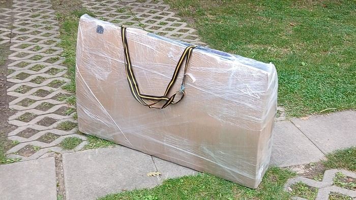
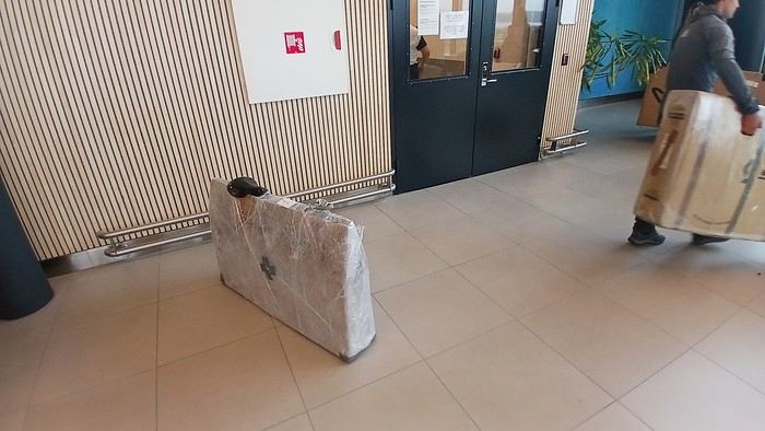
After testing it for three years across various modes of transport, I’m sharing this video of a bike packing case. It’s made from recycled cardboard and shrink-wrapped, with adjustable thickness and added bubble wrap depending on the level of protection you want.
Installing spacers at the fork and chainstays makes the packaging compact. With the fifteen-odd euros for shrink-wrapping at the airport, this case travels really well.
https://youtu.be/_GDJi-GqmkM
- Low bulk (1.10m x 0.70m x 0.25m for a large frame), it fits vertically in train luggage compartments and the total dimensions (x+y+z) don’t exceed 2.40m.
- Two carrying solutions for public transport and easy handling by airport staff (no more tears in the cardboard from openings).
- Discreet packaging when dealing with bus drivers and train conductors, as it looks like an ordinary parcel.
- No need to return to the starting point to retrieve the case from your outbound trip, which you’d otherwise have to store somewhere, or deal with a bulky cover to pack in your panniers.
- You can still check tire pressure through the plastic film without damaging the packaging too much.
Drawbacks: Around 3 hours for this lengthy and meticulous process—removing the wheels, pedals, handlebars, and derailleur without misaligning them, then securing all components to the frame.
If you get a chance to test it, send me your feedback for future improvements.
I just took a trip in Tunisia from Tozeur to Douz, skirting Chott el Jerid to the south. I’m back with the urge to keep going further south via the 4x4 tracks to connect Douz to Ksar Ghilane. Has anyone driven this route recently or explored southern Tunisia?
Thanks for your tips!
fix
😎Fellow traveling cyclists or not, all of you who love travel, the pleasure of physical effort, nature, beautiful machines, people with true passions they seek to fulfill, and who also enjoy reading great literature about all this—the *200* magazine is for you just as it is for me. I should mention I have no financial or other interest in this (in an era where we accuse our politicians of all sorts of vile interests, I prefer to take precautions). I’ve been subscribed since the beginning, and every three months, I get my 130 pages of dreams (the magazine just went from 110 to 130 pages).
It covers everything from the trans-America route to the TCR (Trans Continental Race) from Belgium to a small town in Turkey, with mind-blowing averages—4,000 km and 80,000 m of elevation gain in 8 days and 15 hours for the winner. Let that sink in, and all of it without assistance—accepting a patch could penalize you. There’s also a story about crossing Iran, encountering one of the world’s most welcoming populations, following in the footsteps of Nicolas Bouvier, as well as retirees leisurely traversing France. The common thread in all these stories? Beautiful writing. Take, for example, a stunning article: *"Passengers of the Cold: From Edinburgh to Thurso, at the very north of Scotland, 550 km of moors, coasts, and icy wind. In Thurso, the road ends at a quay, facing the Orkney Islands. We wanted a November trip, off-season. We wanted to surprise winter. Just before the snow."* A sublime piece on the experience of facing adversity and the chance encounters along the road and in the elements.
Before I embarked on my own bike trips, I dreamed a lot about them—from the Atacama to the Gobi, along the Mekong, and not forgetting France. And now, these 130 pages every quarter keep those dreamy vibes alive through stories written in the most beautiful prose.
I’ll stop here because it might sound like I’m advertising, but if you don’t know *200*, I invite you to discover it. It’ll give you wings for the most incredible challenges or simply reinforce your desire for slow rides with your eyes open to others and nature.
A little news to wrap up: Axel Carion and a friend just broke the record for crossing South America from Colombia to Ushuaia in 59 days. On its own, that doesn’t mean much, but I can’t help it—it makes me dream. You should see how he talks about it, the flashes of that wild nature he’s stored away: a snowstorm at Paso Jama and the surreal sight of the suddenly snow-covered Licancabur!
Luc
PS: The magazine is called *200* because a day’s ride starts at 200 km—well, I’ve never done a ride like that since my longest was 167 km (with 18 kg of luggage, mind you), but why not one day? The magazine will explain how to tackle your first 200, and then the question in conclusion: when will you do your first 300?😏
I’ve got my flight ticket sorted—departing in mid-November and returning in mid-March. I’ll arrive in Santiago and leave from Buenos Aires.
I’ve already been to southern Argentina, specifically Torres del Paine National Park, and I’d love to go back to do the full W trek (I only did the shorter version last time).
I also want to do some hiking and maybe even tackle a summit. I climb and occasionally do some mountaineering, so I’ll definitely be going with a guide.
I plan to start around Temuco in Chile, with the idea of heading toward the lakes, then taking the Carretera Austral.
I’m not sure if I’ll go all the way to Ushuaia—it’s supposed to not be *that* worth it, except for the bragging rights of saying you’ve been to the end of the world.
I saw there are lakes in Argentina too.
I don’t have a precise itinerary, but what I’d love is, once I reach the southernmost point of my trip, to take a mini-cruise to see some wildlife. Any tips for that?
What kind of sleeping bag did you take? Is a 0°C (32°F) one enough?
And one last question: white gas stove or can I get by with my gas stove?
I'm developing a free and open-source web app for planning walking and cycling trips (and even car trips). You can create a route by clicking directly on the map to add waypoints, and it can consist of multiple stages. The app provides tools to edit the stages and the overall route, and to display useful information (distances, altitudes, and elevation changes). A relief profile can be shown as a graph for a specific stage or the entire route.
Once the route is ready, it can be exported as a GPX file, which can then be used with a GPS or a mobile navigation app.
The app is built in JavaScript and runs entirely in the web browser. It uses the Leaflet library and several OpenStreetMap-based services. Initially developed for my personal needs (I enjoy hiking and cycle touring), I’d be happy to share it with anyone who might find it useful. It’s free to use, doesn’t require an account, and the source code is available.
hello fellow cycling enthusiasts
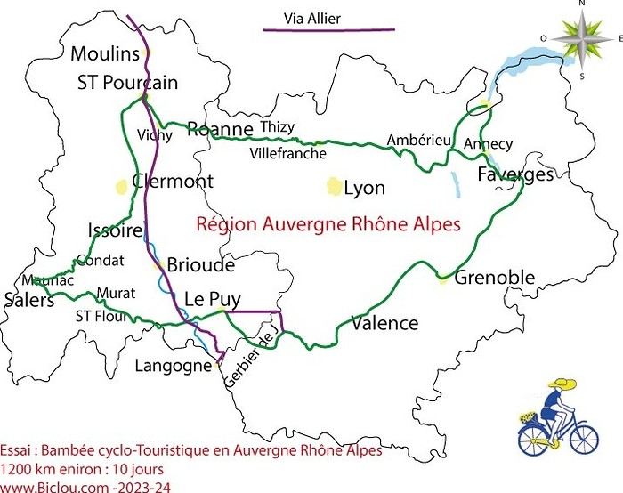
here’s a travel journal of the cycling tour through the Rhône-Alpes Auvergne region by Claudio
zouli
it was the plan
http://cbandiera.free.fr/parcours/auvergne-Ralpes/
the trip was completed
story being posted online soon
1100 km in 11 days
beautiful and varied regions
Hello,
We’d like to go on a 3- to 4-month bike trip starting in December, crossing from Assam (northeast India) to New Delhi via Nepal.
Are there routes with light traffic along the Brahmaputra and through Nepal?
We’re also looking for any info on accommodations, wild camping, local interactions, etc.
Thanks,
Michel
I’m planning to cycle from Morlaix to Brest (via Roscoff and the V45 coastal route). We’ll start riding on August 16th for 13 days (with stops for island visits, surfing, etc.). Is there a lot of traffic at this time of year? I’ve got two kids, 11 and 13, and we don’t like riding in the middle of cars (we’ve already done the Vélomaritime—Caen to Cherbourg—the Loire route from Orléans to Saumur, the Vélodyssée from Nantes to Royans, and the canals like the Nivernais and Bourgogne, where there were plenty of bike-only lanes, which isn’t the case on this route).
Thanks for your help if you’ve already done this route in late August!
Virginie
Hi there,
I’ve been road cycling for several years, and I’m about to switch to gravel in the next few days—I’m waiting for my bike, which should arrive this week.
I’m planning a bikepacking trip in a few weeks along the Véloroute V81, also known as the Vélosud, from Biarritz to Le Barcarès.
Has anyone here already done this route? Any info is welcome, whether it’s about the route itself, gear, or accommodation. I’ll prioritize staying with locals as much as possible. On that note, I just signed up for the brand-new site *Guidon et Couette* ((www.guidon-et-couette.fr)), which offers free accommodation between cyclists across the country, but there’s almost no one listed along my route!
Thanks in advance.
Laurent.
Hi there, I’m planning a cross-Canada bike trip, and I’ve got a question that might seem silly, but could someone tell me how to pack a bike (in a box, with a fragile sticker... I don’t know) for a flight? Thanks in advance!
This summer, we’re planning to cycle along the EV 19 that follows the Meuse River from Langres all the way to Rotterdam.
My question is about getting back to Nantes.
Do any of you know what the best return option might be? I’d love to hear about your experiences.
I saw that FlixBus doesn’t take bikes.
By train, I think it’s possible but would involve multiple local trains.
We were also wondering if there’s a boat from Rotterdam to Saint-Nazaire that could take passengers with bikes.
Any tips or experiences you can share would be really helpful—thanks in advance!
Have a great evening
I’ve gotten used to crossing Europe by bus to return by bike.
It was really convenient to take the bike without having to disassemble it.
But FlixBus no longer accepts bikes...
What alternatives do you know about?
Thanks.
Hi there,
I’m planning to ride the Dutch section of the EuroVelo 19, from Maastricht to Rotterdam.
Since it’s too complicated to bring my bike on the train, I’m looking to rent one locally.
I’d love any tips or bike rental shop recommendations—I’m struggling to find options even in Rotterdam.
The plan is to rent in Rotterdam, take the train to Maastricht with the bike, then cycle back to Rotterdam.
Thanks in advance for any advice or suggestions!
Nath