Bonjour à tous
la décision est prise, la prochaine rando c'est faire le tour de l’Australie.
Je m'adresse ici à ceux qui ont roulés là-bas, c'est le début du projet, la trace... voici les grandes lignes:
le tour de l’Australie (ou moins si pas le temps, fin possible en bus) en 6 mois
Nous aimons rouler 80kms / jour, plus quand c'est nécessaire (mon record 190kms en fin de rando cet été)
nous sommes 2 et voulons partir en mars 2013
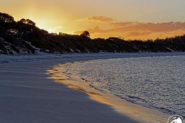
Compte tenu de la saison, je me demande ou commencer et dans quel sens tourner? L'idée est de longer la mer au max.
J'ai un pote à Sydney, donc si c'est jouable, ça serait plus facile de partir de là-bas (trouver des vélos, les équiper...)
Les paramètres que je met en priorité: le vent, les nuisances (mouches moustiques...) la chaleur.
J'envisage l'achat d'une remorque pour pouvoir transporter plus d'eau et nourriture
Ce que nous recherchons avant tout c'est une aventure avec la nature (camping sauvage)
Questions:
Partir d’où pour être dans la bonne saison (départ mi mars) et tourner dans quel sens?
routes à ne pas manquer / routes ou régions déconseillées (compte tenu de la saison?)
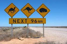
Nous n'avons pas d'expérience avec les crocodiles ou autre bébêtes dangereuses. Recommandations???
Voilà pour dégrossir, merci d'avance pour tous vos conseils
bruno
PS coté visa, c'est 3 mois qu'on renouvèle sur place non?
bonjour
le tour de laustralie cest 15.000 km, 9 mois environ. vous pouvez partir de sydney debut mars, en allant vers cairns, darwin, brome, perth, adelaide, melbourne, sydney. cest le bon sens.
les routes a eviter, je vous dirai pour ainsi dire toutes celles que vous allez suivre en collant a la cote. trop de trafic, trop de steppe desertique, trop de routes qui passent par nulle part.
et surtout la route sydney cairns, et perth albany.
pour catherine brome il faut suivre par la piste, kimberley digg river road. le seul coin dangereux vous demandez a une camionette pour le franchir.
pour les bestioles, il ny en a quasiment pas en australie, pas de pb.
pour la remorque, non le bus la refuserait, et ce nest pas necessaire. vous aurez besoin de 4 a 5 jours de nourriture partout, et de 3l deau. dans les deserts 8l deau. il y a des citernes deau de pluie partout, et en absence, des campings et les gray nomades, ces dizaines de milliers de gens qui la parcourent en caravane, qui vous donneront de leau et vous vendront de la nourriture.
pour le visa cest 3 mois puis a renouveler dans une capitale regionale, si vous avez plus de 30 ans il faut un billet retour, la preuve de ressources suffisantes, soit 3000$ par mois, et une assurance sante, tout ca en anglais, traducteur officiel 100$ plus cout du visa 260$.
autre solution aller en indonesie 2 semaines et revenir, de darwin. on vous redonne 3 mois. si vous avez moins de 30 ans vous avez le visa tourisme travail dun an.
entre temps jai fini mon voyage tu peux aller voir sur mon site au tag australie.
a + pierre
tout le monde prétend que la Terre est ronde, mais ne le croyez pas, en fait elle est plate bien sûr!
http://mandolpierre.overblog.com
bonjour,
Juste pour confirmer le message du dessus, c'est exactement ce que j'allais dire! Il faut absolument éviter d'être dans le Nord en été car il fait beaucoup trop chaud, et également éviter de faire la Nullarbor (Espérance/ Adélaïde) en été. Il est déjà fortement déconseillé de la faire en véhicule en plein été alors en rando vaut mieux pas y penser! (les saisons étant bien évidemment inversées par rapport à la france 😉).
Pour les visas, même chose....je crois que tout est dit dans le message précédent! 😛
Peut-être que je vous croiserai sur la route, j'y retourne dans 10 jours! Vous allez voir, l'Australie c'est magique 🙂!
J'ai fait du velo au sud de Sydney dans les Southern Highlands, Canberra, le Great Ocean Road a l'ouest de Melbourne, et en Tasmanie. J'ai surtout aime Tasmanie. Mais le climat y est different et il faut le faire tout au debut si tu commences en mars. Les Southern Highlands nous ont un peu decu. Le Great Ocean Road est assez jolie.
Les mouches etaient un probleme a Royal National Park (au sud de Sydney) mais pas aux autres endroits que j'ai visite. Beaucoup d'especes de serpents en Australie sont veneneux. Toutes les 3 especes de serpent en Tasmanie sont veneneux, et c'est le seul endroit ou j'ai vu un serpent (pendant une randonnee a pied dans un parc national). Bien que pas mal de serpents en Australie sont tres veneneux, ils sont timides en general.
merci à tous pour ces infos.
Je ne savais pas qu'il fallait tant de choses pour l’extension du visa... j'ai 50 piges...et pas de salaire. Il reste l'option de sortir et re rentrer mais ca va faire un trou dans le budget...
Coté climat, comme je l'ai dit, je part pour l'automne et l'hiver. Il me semble plus judicieux de partir de Cairn pour faire le sud à l'automne et le nord en hiver. Pour info j'ai trouvé une carte des vents:
http://www.bom.gov.au/climate/averages/wind/wrselect.shtml
Il parait qu'il faut payer pour entrer dans les national parks?
Bon, ca avance...
bonjour
cairns cest au nord. en mars il pleut encore pour un mois.
en partant de sydney tu peux soit aller a cairns par les petites routes de linterieur soit aller a melbourne puis adelaide par la cote. ceux sont 2 belles options, tu peux les voir sur mon site, en anglais. en plus jindique ou dormir gratis.
perso jai campe dans les aires de repos et les terrains de sport et les pony club et les comunity houses, sans payer. en velo il y a une tolerance.
pour les parcs lentree est gratuite ou 6$ et le camping payant 6$ par nuit. mais en tant que cicliste le ranger ne te fais souvent pas payer, et tu peux camper dans les aires de picnic du parc la cest gratuit pour une nuit. et puis dans les parcs avec payement spontane tu peux oublier...
pour le nord la meilleure saison cest de avril a fin juillet. apres il fait tres chaud puis il pleut.
pour le sud ouest perth esperance le mieux cest novembre decembre. cest les fleurs.
pour la tasmanie le mieux cest decembre janvier.
je te suggere deviter cairns darwin, la route 1 est impraticable et la 2 est super ennuyeuse, brome perth tres tres ennuyeux et venteux, nularbor desert, profond ennui et vent et chaleur, darwin alice spring ennueux.
par contre les 2 parcs pres de darwin cest bien et katherine brome aussi, et alice spring port augusta. puis flinders ranges adelaide par les petites routes tres bien.
le stop marche plutot bien en australie.
pour le vent il vient en general de l est, de sydney vers perth. mais cest une generalite.
darwin alice spring adelaide il vaut mieux le faire en partant du sud et en allant vers le nord.
katherine brome et esperance perth en partant de lest, katherine et esperance, vers brome et vers perth.
un vol davion 200$ +30$ pour le velo avec quantas cest le mieux. bus perth esperance 90$ .
avion darwin ou brome indonesie 100$ avec le velo.
pour aller en australie emirates airlines, velo + 10kg de bagages + 7kg bagage a main, ca tourne, 1100 euros AR
et si tu veux faire un voyage interessant, regarde un livre de lhistoire de laustralie, un livre de lexploration, un livre sur les arbres tu trouveras un petit a perth, et un sur les noirs the triumph of the nomads.
bonne route.
tout le monde prétend que la Terre est ronde, mais ne le croyez pas, en fait elle est plate bien sûr!
http://mandolpierre.overblog.com
bonjour
cairns cest au nord. en mars il pleut encore pour un mois.
en partant de sydney tu peux soit aller a cairns par les petites routes de linterieur soit aller a melbourne puis adelaide par la cote. ceux sont 2 belles options, tu peux les voir sur mon site, en anglais. en plus jindique ou dormir gratis.
perso jai campe dans les aires de repos et les terrains de sport et les pony club et les comunity houses, sans payer. en velo il y a une tolerance.
pour les parcs lentree est gratuite ou 6$ et le camping payant 6$ par nuit. mais en tant que cicliste le ranger ne te fais souvent pas payer, et tu peux camper dans les aires de picnic du parc la cest gratuit pour une nuit. et puis dans les parcs avec payement spontane tu peux oublier...
pour le nord la meilleure saison cest de avril a fin juillet. apres il fait tres chaud puis il pleut.
pour le sud ouest perth esperance le mieux cest novembre decembre. cest les fleurs.
pour la tasmanie le mieux cest decembre janvier.
je te suggere deviter cairns darwin, la route 1 est impraticable et la 2 est super ennuyeuse, brome perth tres tres ennuyeux et venteux, nularbor desert, profond ennui et vent et chaleur, darwin alice spring ennueux.
par contre les 2 parcs pres de darwin cest bien et katherine brome aussi, et alice spring port augusta. puis flinders ranges adelaide par les petites routes tres bien.
le stop marche plutot bien en australie.
pour le vent il vient en general de l est, de sydney vers perth. mais cest une generalite.
darwin alice spring adelaide il vaut mieux le faire en partant du sud et en allant vers le nord.
katherine brome et esperance perth en partant de lest, katherine et esperance, vers brome et vers perth.
un vol davion 200$ +30$ pour le velo avec quantas cest le mieux. bus perth esperance 90$ .
avion darwin ou brome indonesie 100$ avec le velo.
pour aller en australie emirates airlines, velo + 10kg de bagages + 7kg bagage a main, ca tourne, 1100 euros AR
et si tu veux faire un voyage interessant, regarde un livre de lhistoire de laustralie, un livre de lexploration, un livre sur les arbres tu trouveras un petit a perth, et un sur les noirs the triumph of the nomads.
bonne route.
Bon Pierre, tu m'aides ? Je serai en Australie d'ici 8-10 jours. Tout le monde m'ayant fait peur avec la saison des pluies et les crocodiles sur la route j'ai décidé d'aller plutôt du Nord vers le Sud. Evidemment je veux du soleil, un vent favorable, pas de circulation, pas de camions tueurs et de beaux paysages. le minimum de pistes, je souffre vraiment beaucoup sur les pistes.
Je n'ai pas réussi à trouver ton tag d'ailleurs je ne sais pas ce que c'est un tag...
Je n'ai pas bien compris pour le visa, une fois les démarches faites (puis-je les faire à mon arrivée à Sydney ?) ai-je un visa pour un an ou c'est à recommencer tous les trois mois ?
Merci d'avance, j'espère que les ours ne t'ont pas mangé
pour lire mon voyage en australie cest sur crazyguyonabike en cherchant mandolpierre
http://www.crazyguyonabike.com/doc/australiamp
cest en franglish, cest a dire des mots anglais et des expressions et tournures francaises, du petit kangourou quoi.
pour le visa tu dois remplir une demande sur internet avant ton arrivee, pour obtenir un visa de 3 mois, et cest gratuit;
20 jours avant la fin des 3 mois, tu vas au service immigration dune capitale regionale, et tu demandes une extension pour une année. ca coute 255$.
Il faut le faire avant la fin du 1er visa, apporter la preuve quon a un revenu de 3000$ par mois, un domicile, si possible un billet retour, une couverture medicale; tous ces papiers doivent etre en anglais il faut donc les faire traduire par le traducteur officiel, ca prend 2 semaines et ca coute 100 a 200$. donc il faut prevoir ce delai, demander le visa 20 jours avant la fin, et aller faire un tour en attendant la traduction;
autre solution, sortir de laustralie au bout de 3 mois, et revenir 8 jours plus tard, on vous donne gratis un nouveau visa de 3 mois; mais ca coute le billet davion AR, et pas sur que ca marche 2 fois, donc pas forcement interessant.
Pour laustralie, je suppose que tu arrives a Darwin.
il y a 2 beaux parcs a darwin ville vers laeroport, en velo cest simpa. et cest la seule grande ville avant 2 mois, achete tout ce dont tu as besoin;
de la tu fais les 2 grands parcs, litchfield et kakadu; pour kakadu il faut entrer dans les petites routes cahoteuses sur 10 km pour voir les choses interessantes;
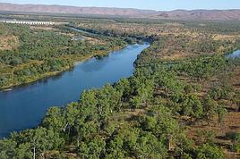
apres quoique tu naimes pas les pistes, je te suggere de faire Kimberley Gibb River road. cest pile la saison, et il y a plein de crocodiles affamés. mais tu auras vent dans le dos. en fait cest la route Nord qui va de Katherine, la ville du gagneur du tour de france en 2012, a Brome sur la cote Ouest. il faut visiter le parc Gregory, et ensuite suivre la route. pour les rivieres a croc, il suffit de demander a un 4*4 de te transporter, pas de risque ni de refus.
cest la et les pages suivantes jusqua Halls creek
http://www.crazyguyonabike.com/doc/page/?o=1&page_id=218876&v=Ki
un autre site utile
http://www.kimberleyaustralia.com/camping-in-western-australia.html
quand tu arrives a Brome tu prend lavion pour ailleurs, Bali par exemple. et apres un repos merité tu reviens en Australie. quelque soit la periode, il y fait toujours beau quelque part.
L'autre solution quand tu arrives a Pines creek ou Katherine, cest de prendre le bus jusqua Alice Spring, et ensuite de suivre mes traces jusqua Adelaide, cest presque tout asfalte. cest la et beaucoup de pages suivantes.
http://www.crazyguyonabike.com/doc/page/?o=1&page_id=296819&v=5K
encore un site utile, qui repertorie tous les trails a faire en bici en Australie.
http://www.cycletrailsaustralia.com/
il passe par des pistes, jai suivi ses traces mais je suis passé par des petites routes goudronnées paralleles en general.
ben tas plus qua lire, ce que tu naimes pas, et pedaler, bon courage, et merci pour les fotos de NZ
bonne route Pierre
tout le monde prétend que la Terre est ronde, mais ne le croyez pas, en fait elle est plate bien sûr!
http://mandolpierre.overblog.com
Alors, voilà je me présente, je m'appelle Thomas et j'ai 18 ans. Mon projet serait de partir pendant 1 ans en Australie à vélo avec un Visa "Working holiday",…
On part dans trois semaines (aie aie aie!!) pour un tour du monde sac à dos et on sera en octobre en Australie. on a prévu une petite semaine en Tasmanie pour…
J'ai du temps en mars, surement un mois et je ne sais pas trop comment les occupés. Je me suis dit pourquoi pas un peu de vélo en Australie. Si vous avez des…
Ca y est j'ai mon billet d'avion, départ mi novembre, retour mi-mars.
arrivée santiago et je repars depuis Buenos Aires.
J'ai deja été dans le sud de l'argentine, notamment le parc torres del Paine, et j'ai très envie d'y retourner pour faire le grand W, j'avais fait le petit.
Je souhaite aussi randonner qq foois et pourquoi pas faire un sommet. Je grimpe et je fais occasionnellement de l'alpinisme, donc ce sera avec un guide de toute façon.
Je compte démarrer vers temuco au chili, j'ai dans l'idée d'aller vers les lac, puis prendre la careterra austral.
Je sais pas si je vais aller jusqu'à Ushuaia, parait que cela vaut pas tant que cela la peine, à part pour dire qu'on a été au bout de la terre.
j'ai vu vite fait qu'il y'avait des lac en Argentine.
Je n'ai pas d'itinéraire précis. Mais ce que je souhiaterai, c'est qu'une fois arriver le plus au sud de mon vooayage, faire une mini croisière pour voir des annimaux.
Des conseils pour cela?
qu'avez vous pris comme sac de couchage? un 0 degré suffit?
et ultime question, réchaud à essence ou est-ce que je peux m'en sortir avec mon réchaud gaz?
Cet été nous prévoyons de pédaler sur l'EV 19 qui longe la Meuse de Langres jusqu'à Rotterdam.
Mon questionnement concerne le retour jusqu'à Nantes.
Savez vous quel est le meilleur retour possible? J'en appelle à vos expériences.
Je voyais que Flixbus ne prenait pas les vélos.
En train, je pense que c'est possible avec de multiples petits trains.
On se questionnait aussi sur l'existence d'un bateau qui irait de Rotterdam jusqu'à St Nazaire et qui pourrait charger des passagers avec vélos.
Toutes vos expériences partagées nous seront bien utiles et nous vous en remercions.
Bonne soirée
Je souhaite faire Morlaix Brest ( via Roscoff et la littoral V45) nous commencerons à rouler le 16 aout pour 13 jours (avec des pauses visites iles , surf etc..) Est ce qu'il y a beaucoup de circulation à cette époque de l'année car j'ai 2 enfants de11 et 13 ans et on n'aime pas rouler au milieu des voitures (on a déjà fait velomaritime ; Caen - Cherbourg, loire : Orléans- Saumur, Velodyssée : Nantes - Royans, les canaux : nivernais , bourgogne etc ... et il y avait beaucoup de voies réservées aux vélos ce qui n'est pas le cas sur cet itinéraire).
Merci de votre aide si vous avez déjà parcourue cet itinéraire fin aout.
Virginie
Hi there,
I’ve been road cycling for several years, and I’m about to switch to gravel in the next few days—I’m waiting for my bike, which should arrive this week.
I’m planning a bikepacking trip in a few weeks along the Véloroute V81, also known as the Vélosud, from Biarritz to Le Barcarès.
Has anyone here already done this route? Any info is welcome, whether it’s about the route itself, gear, or accommodation. I’ll prioritize staying with locals as much as possible. On that note, I just signed up for the brand-new site *Guidon et Couette* ((www.guidon-et-couette.fr)), which offers free accommodation between cyclists across the country, but there’s almost no one listed along my route!
Thanks in advance.
Laurent.
I’m planning to build a new touring bike.
I want to prioritize lightness.
That said, I’m tempted by a suspension fork that could offer some comfort on rougher roads.
The recent appearance of gravel suspension forks on the market might meet my needs—at least on paper.
I’m particularly considering the RockShox Rudy Ultimate XPLR fork.
Unlike MTB forks, its travel is short: either 30 mm or 40 mm.
It weighs 1400 g, which is 400/500 g more than a steel fork.
Any thoughts or real-world feedback on this?
I’m also wondering about the durability of magnesium (lower leg) for long-distance bike touring.
And what’s the impact of skipping the manufacturer-recommended maintenance every 50 and 200 hours? That’s bound to happen on a long trip unless you carry extra gear.
More generally, how reliable are these kinds of forks?
Hi everyone,
I wanted to share with you the incredible feat my friend José, who’s 72 years old, is currently undertaking. He left Auterive near Toulouse on Monday, May 18, 2026, on his non-electric bike, heading for the North Cape in Norway!
You can follow his route on the link below—he’s currently in Sweden:
https://thierry-thomas.travelmap.net/jose-de-toulouse-a-nord-cap-2026
You can zoom in on the map and click on each stopover town to see the photos
I’m making an exception and creating a separate post this time, since it’s all about France. In May, we spent a week in Provence, specifically in the Luberon, exploring the cycling routes *Autour du Luberon à Vélo*, the *Véloroute du Calavon* (part of EuroVelo 8), and the shorter *Les Ocres à Vélo* route. Together, they gave us an amazing journey through rolling hills, vineyards, lavender fields still green in spring, and some of the most stunning landscapes in southern France.
It was, of course, the perched villages that impressed us the most. We visited Gordes, Roussillon, Bonnieux, Lacoste, Lourmarin, Ménerbes, Oppède-le-Vieux, Cucuron, and Lauris. Many of them are among the most beautiful villages in Provence, and it’s hard not to agree with that reputation.
One interesting point is the route of EuroVelo 8 in this part of the region. The official path mainly follows the old railway line of the *Véloroute du Calavon*, which is very comfortable and safe. But in our opinion, cyclists traveling EuroVelo 8 around the Mediterranean would discover even more treasures if the route passed through villages like Bonnieux, Lacoste, or Oppède-le-Vieux.
We were also pleasantly surprised by how safe cycling felt. Most of the route takes small local roads, but traffic is light, drivers are respectful, and road design really takes cyclists into account. It’s one of those places where you can ride peacefully even without separated bike lanes.
Our full story:
Around Luberon by bicycle - the most beautiful villages of Provence
You can also find all our cycling travel stories on the forum:
Cycling Thread - Europe’s most beautiful bike routes
Hi there, we’re a group of 4 cyclists looking to get from Treviso in Italy to Munich with our 4 non-folding bikes. It seems complicated! Are there any solutions? Thanks so much.
hello fellow cycling enthusiasts
here’s a travel journal of the cycling tour through the Rhône-Alpes Auvergne region by Claudio
zouli
it was the plan
http://cbandiera.free.fr/parcours/auvergne-Ralpes/
the trip was completed
story being posted online soon
1100 km in 11 days
beautiful and varied regions
Hi there, we’re planning a Munich to Venice bike trip at the end of June 2026. Getting back from Venice to Toulouse by train with 4 bikes isn’t straightforward. What return options have others who’ve done this trip chosen? Any tips or great deals would be much appreciated. Thanks a bunch! !
Hi everyone,
Happy owner of a Pegasus Estremo bike with a Rohloff hub, which is giving me trouble with the SF11-NCX-FT-E-LITE 700C TS 300/0 fork (serial number TD01329060). It’s starting to show its age, and I’d like to repair it to extend the life of my beloved bike.
The suspension is gone, and there’s an oil leak from the seals.
Does anyone know how to repair it? Where can I find parts that are about fifteen years old? Or where to find an identical replacement fork? Just to clarify, the Magura HS11 brakes are mounted using Firm Tech, meaning they’re on pivots behind the fork, facing the frame.
Hi, I'd like to know if anyone has done this route recently or has reliable info.
Does the track exist, and most importantly, is there sand (for biking)?
Any info is welcome.
Cheers,
diego ambilobe: mangaoka, manondro, ramena
vohemar sambava: masondrono, tanambao
Hi there,
New to bike touring,
I’d love to start with a section of the Via Rhona to explore and share (route to be decided).
Looking forward to exchanging tips!
I’m landing in Madagascar with a buddy before the end of April 2026. We’re planning to bike around for about twenty days or so. We don’t have a specific goal other than exploring the country and meeting the locals.
Ideally, we’d prefer a loop route starting from Antananarivo with a good chunk of it along the coast. On the bike side, we’re used to riding 6 to 8 hours a day, depending on the needs, encounters, and mood 😉 Any feedback or tips from trips around this length?
A big thank you to Lazarou for all the info you share in this forum!
I'm passionate about Morocco, which I cycled through back in 2009.
Last year, my wife and I explored the High Atlas by tandem. Completely smitten, we're heading back in April (Anti Atlas) and May (High and Middle Atlas), still on our tandem.
Do you have any info on the track between Amezri and Ali Ait Nito? Are the river crossings in the Tessaout still there? It's not easy to navigate with a loaded tandem... especially if the river level is high due to this year's heavy snowmelt!
Thanks in advance for any tips you might have, and best wishes for health in this new year!
Claudio specializes in the route of the Savoie lakes
Here are his travels
Between Bornes, Chartreuse, the Savoie foothills, and Dauphiné
Five lakes: Léman, Annecy, Paladru, Aiguebelette, Bourget, not to mention a few ponds along the way
Plenty of accommodation options: camping, hotels, and more...
A lovely route not far from his place
Rural and quite peaceful
A road cycling route created by Serge B...
Tout d'abord... bonne année ! De belles routes à vous en 2017 !
Je voyage depuis quelques années avec un VTT de très bonne qualité mais équipé de freins à disques hydrauliques. Je vis (pédale) avec l'inquiétude d'avoir une panne (fuite, bulle d'air, chaleur qui fait que le liquide...). Mon vélociste me dit qu'il est impossible de les changer pour des V brakes.
Qu'en pensez-vous ? Est-ce que je prends un gros risque à continuer (seule) avec ces freins ? D'avance je vous remercie pour vos bonnes idées.
First post here to share a quick recap of our west-to-east bike trip along Algeria’s coast in January 2025.
It was just the two of us—my partner and I—with French passports and not a word of Arabic. No friends or welcoming hosts in the country.
Under those conditions, we’d strongly advise against going.
Our original plan was to follow the coast from Algiers to Tunis. We ended up cycling from Algiers to Béjaia, then took the train from Béjaia to Annaba (with a stop in Constantine), and finally biked to the border.
We were tailed by police the whole way—whether on our bikes, on the train, or even on foot while exploring towns. On top of that, we couldn’t wild camp and were limited to the few state-approved hotels that accept foreigners. Under those circumstances, connecting with locals was especially tough.
With such an omnipresent and intrusive police presence, we’d definitely recommend against this destination for bike touring. A really sad situation that completely cuts you off from the local population...
We’d been warned, we went to check it out, and we weren’t disappointed!
Hi there,
I’m planning the route to cycle from Lille to Nordkapp with my partner.
Duration: 3 months, from May 1st to July 31st, 2026.
In the attached details below, I need to add some "non-riding" days (rest days, basically).
So I’m looking to "shorten" the trip by taking ferries or trains for some stretches. Which areas could I skip?
Thanks in advance for your great tips.
Have a good evening.
https://www.komoot.com/fr-fr/collection/4023980/-lille-cap-nord-1er-mai-au-31-juillet-2026?ref=collection
I’m planning to bike back from Poland this summer. Does anyone know a way to ship it there without having to take it apart? Otherwise, it’s a real hassle to fine-tune all the settings before departure!
Thanks in advance.
Hi, has anyone recently bought Primus or Butagaz gas, possibly puncture-style, in Dubrovnik or the surrounding area? Same question for Albania... thanks. aichatou
Just a few words about the loop I did by bike in Yunnan.
Entry and exit
I entered China through the Sino-Vietnamese border crossing at Lào Cai / Hekou under the 30-day visa exemption currently available to French nationals and others.
The process was simple and quick. A Chinese police officer even helped me complete my electronic pre-registration at a computer kiosk. I wasn’t aware this formality was required—it’s similar to Thailand’s TM6.
No issues with the bike.
I left the country via the Sino-Laotian border crossing at Mohan / Boten.
The atmosphere was a bit chaotic there, but again, no problems with the bike.
The timing
I visited Yunnan in February 2026.
Weather-wise, at higher altitudes (between 1,500 and 2,000 meters), it was around ten degrees at night and in the mornings, and around twenty degrees at the hottest part of the day.
I had two days of rain, so I took the bus to keep moving. Otherwise, clear blue skies.
Culturally, Chinese New Year fell on February 17th (and the 15 days following), right in the middle of my trip. Because of this, my take on the traffic might be off.
Accommodation and food
I always found a hotel to stay in for prices ranging from 8 to 15 €. Except in Kunming (the capital), where many hotels were fully booked (Chinese New Year). I ended up at a 100 € hotel with great value for money.
A bowl of noodles costs about 1.5 € on average.
Onboard electronics
Since my smartphone doesn’t support eSIMs, I subscribed to a China plan with my carrier. Otherwise, for much cheaper, Alipay offers eSIMs for foreigners that allow access to services usually blocked for Chinese users (WhatsApp, Facebook, etc.).
An internet connection is essential for paying with Alipay or WeChat, as this payment method is widespread.
I only managed to use Alipay.
Either way, always carry cash because sometimes there’s no signal, or the merchant only accepts WeChat.
Also, it’s best to bring a power adapter when you arrive rather than struggling to find one.
Traffic and roads
The Chinese aren’t reckless drivers. They follow traffic rules and watch out for cyclists. This is slightly less true in Xishuangbanna (the region bordering Myanmar and Laos).
In urban areas, there are almost always wide bike lanes, separated from other roads, where bikes, electric mini-scooters, and scooters share the space pretty harmoniously.
The roads are in great condition, and traffic is generally manageable—even light—except for one stretch (Eshan -> Yangwu).
Most traffic is absorbed by expressways, China’s equivalent of highways: toll roads that are off-limits to slow vehicles.
You’re never far from these expressways; sometimes you even ride alongside them, which can be noisy at times.
The climbs are usually reasonable, around 5% to 6%. From what I remember, the steepest section was between Menglun and Mengla, with gradients of 8% to 10%, sometimes more.
Riding at these altitudes—though modest—took a bit of getting used to.
The route
I didn’t plan anything in advance. My only goal was to reach Kunming. I don’t know why, but just hearing the name of that city, like Yunnan, always felt dreamy to me.
Hi! I’m planning to visit the Stockholm Archipelago by bike in early April.
Do you know if the boats will be running between the different islands at that time of year? For those who’ve already been, all your tips and recommendations are welcome—accommodation, etc. Also, do you know where I can rent a bike in Stockholm? Thanks so much in advance for your help!
Hello there, pedal-powered Young Boys!
Claudio (still from Faverges)
dreaming about a cycling getaway in Italy from Faverges (train all the way to Turin)
from Turin down to Venice along the Po River and back via the Padana (Alta Italia da attraversare – Northern Italy to cross)
The tricky part is getting from Chioggia to Venice.
I read it’s possible by hopping on a boat from island to island,
but it sounds a bit stressful.
Has anyone already tackled this route?
I’m currently looking for a bike to do my first bike trip across France, with the ultimate goal of cycling through Latin America. I’ve got a lot of questions and I’d love to hear if you have any answers or advice to share.
First off, I’ve been through this before with hiking. I want to get top-quality gear right away. When I started hiking, I ended up buying everything three times—first beginner gear, then intermediate, then expert, etc.
For biking, I’d prefer to skip that process and invest right now in a bike that could ideally handle Latin America.
I’ve set a total max budget of around 5000 € (roughly 4000–4500 € for the bike and the rest for accessories: panniers, helmet, cycling shorts, etc.).
So, I’ve got quite a few questions:
* I’ve read in several places that some people recommend buying the bike directly in Latin America. Since I need a first bike to train in Europe, would it be better to buy an entry-level bike in France (and sell it before the big departure)? Or is it preferable to start right away with my final bike to get used to it? Is buying it there just to save a bit of money?
* For a long-term trip (around six months) in Latin America, is it better to go for a gravel bike or a mountain bike?
* Should I buy a new bike or a refurbished one? Even more so given that I’m planning a long trip—could a refurbished bike end up causing more breakdowns?
If you have any advice on models, technical features to prioritize, or recommended sellers or resellers, I’d love to hear it. I’m a total beginner—I’ve only just started watching videos and reading up on the subject, and all the technical specs are new to me!
Calling all travelers.
We’ll be landing at Lyon Airport and want to bike to La Verpillière train station (with panniers and camping gear, etc.) to catch a TER to Voreppe.
What’s the safest route for this bike trip?
Thanks in advance
hi,
I'm planning a recumbent bike trip from the Pyrenees to Greece. On the EuroVelo 8 route, it doesn't specify the path through the Alps.
Are there any experienced cyclists here who can tell me where they go to avoid climbing too high?
Also, is there another traveler/bike forum better suited for broadening the responses?
thanks