Skip to content
Hokkaido

Travel guide · Japan

Hokkaido

★ 3 · last edited Dec 11, 2019

This is the northernmost of Japan’s main islands. Quite different from the others, it is a wild land with a harsh climate, featuring mountains, volcanoes, lakes, and forests teeming with diverse wildlife. You’ll also find several beautiful national parks, such as Daisetsuzan and the Shiretoko Peninsula. The region’s main draw is its natural environment and outdoor activities, far outweighing the few cities, which are not particularly appealing. In short, the island is primarily a nature-and-adventure destination.

Overview

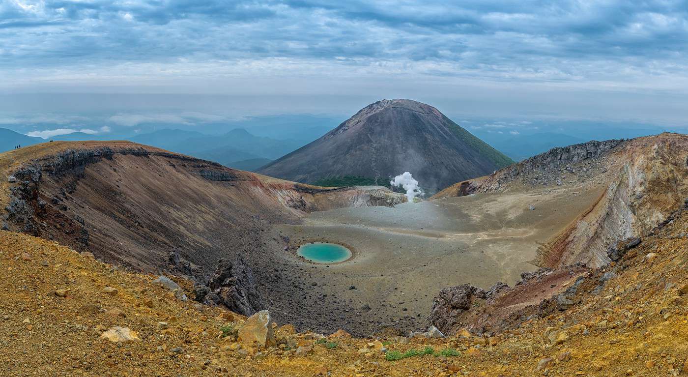
Parc national d'Akan, Japon
Parc national d'Akan, Japon · © VoyageForum

This is the northernmost of Japan’s main islands. Quite different from the others, it is a wild land with a harsh climate, featuring mountains, volcanoes, lakes, and forests teeming with diverse wildlife. You’ll also find several beautiful national parks, such as Daisetsuzan and the Shiretoko Peninsula. The region’s main draw is its natural environment and outdoor activities, far outweighing the few cities, which are not particularly appealing. In short, the island is primarily a nature-and-adventure destination.

Key Facts

  • Type of place: tourist region.
  • Location: the northernmost of Japan’s main islands.
  • Local time: Heure : Hokkaido
  • Main cities: Asahikawa, Hakodate, Sapporo, Wakkanai...
  • Population: 5,382,000 (2016).
  • Area: 83,456 km²
  • Density: 64 inhabitants/km².
  • Highest point: Asahidake (2,290 m).
  • Lowest point: sea level.
  • Coastline:
  • Highlights (out of ): Nature ; Adventure ; Culture ; Relaxation/Holidays /

Main Cities

Tourist Attractions

Cities and Heritage

Beaches and Coastline

Nature and Outdoor Activities

Climate and Weather in Sapporo

Abashiri

A small city on the northern coast known for its former political prison, now a museum. Stunning winter icebreaker tours depart from the port.

Overview of Abashiri

A small city on the northern coast of Hokkaido, known for its former political prison, now turned into a museum. You can take stunning winter icebreaker tours from the port.

Key Facts

  • Type of place: small town.
  • Tourist interest: (worth a stop if you are in the area).
  • Location:
  • Distances:
  • Local time: Heure : 20883.
  • Population: 35,742 inhabitants (2018).
  • Area: 471 km².
  • Altitude: sea level.

History of Abashiri

What to See and Do in Abashiri

In the Surrounding Area

Climate and Weather in Abashiri

Transportation

Getting There

Getting Around

Accommodation

Food

Useful Addresses

  1. == Additional Information
View guide page: Abashiri

Asahikawa

It's the second-largest city in Hokkaido and one of the coldest in Japan. The city mainly serves as a base for exploring the surrounding area (including Daisetsuzan National Park) or enjoying the ski resorts (Kamui, Biei, Furano, etc.).

Overview of Asahikawa

It's the second-largest city in Hokkaido and one of the coldest in Japan. The city mainly serves as a base for exploring the surrounding area (including Daisetsuzan National Park) or enjoying the ski resorts (Kamui, Biei, Furano, etc.).

Key Facts

  • Type of place: city.
  • Tourist interest: (worth a stop if you are in the area).
  • Location:
  • Distances:
  • Local time: Heure : 20884.
  • Population: 338,879 (2018).
  • Area: 747.66 km².
  • Altitude: 116 m.

History of Asahikawa

What to See and Do in Asahikawa

In the Surrounding Area

Climate and Weather in Asahikawa

Transportation

Getting There

Getting Around

Where to Stay

Where to Eat

Useful Addresses

  1. == Additional Information
View guide page: Asahikawa

Hakodate

A historic city nestled in its bay, featuring distinctive architecture, several old forts, and an interesting market. Nearby lakes offer outdoor activity opportunities.

Overview of Hakodate

A historic city nestled in its bay, featuring distinctive architecture, several old forts, and an interesting market. Nearby lakes offer outdoor activity opportunities.

Key Facts

  • Type of place: city.
  • Tourist interest: (worth seeing).
  • Location:
  • Distances:
  • Local time: Heure : 20885.
  • Population: 260,587 inhabitants (2018).
  • Area: 677.86 km².
  • Altitude: sea level.

History of Hakodate

What to See and Do in Hakodate

In the Surrounding Area

Climate and Weather in Hakodate

Transportation

Getting There

Getting Around

Accommodation

Dining

Useful Addresses

Further Reading

View guide page: Hakodate

Niseko

Not far from Sapporo, this winter sports resort is one of the most popular in Japan. Great hikes in summer too, as well as rafting and other outdoor activities.

Overview of Niseko

Not far from Sapporo, this winter sports resort is one of the most popular in Japan. Great hikes in summer too, as well as rafting and other outdoor activities.

Key facts

  • Type of place: ski resort.
  • Tourist interest: (worth a stop if you are in the area).
  • Location:
  • Distances:
  • Local time: Heure : 20886.
  • Mountain range:
  • Associated resorts: 6.
  • Population: 5,173 inhabitants (2018).
  • Area: 197.13 km².
  • Altitude:

History of Niseko

Climate and weather in Niseko

Precautions

Facilities and activities

Ski area

  • Opening period:
  • Number of runs:
  • Length of runs:
  • Cross-country ski trails:

Other winter activities

Summer activities

Transport

Accommodation and dining

What to see and do nearby

Further reading

View guide page: Niseko

Noboribetsu

This southern locality is home to Hokkaido’s main outdoor hot springs, highly renowned in Japan. Also features a small "bear farm."

Overview of Noboribetsu

This southern locality is home to the main outdoor hot springs of Hokkaido, highly renowned in Japan. Also worth seeing is a small "bear farm."

Key Details

  • Type of place: small town.
  • Tourist interest: (worth a stop if you are in the area).
  • Location:
  • Distances:
  • Local time: Heure : 20887.
  • Population: 48,566 (2018).
  • Area: 212.21 km².
  • Altitude:

History of Noboribetsu

What to See and Do in Noboribetsu

In the Surrounding Area

Climate and Weather

Transportation

Getting There

Getting Around

Accommodation

Dining

Useful Addresses

  1. == Further Information
View guide page: Noboribetsu

Otaru

Near Sapporo, this port city is a popular tourist destination, known for its cuisine, shops, canal, and historic buildings.

Overview of Otaru

Near Sapporo, this port city is a popular tourist destination, known for its cuisine, shops, canal, and historic buildings.

Key Facts

  • Type of place: city.
  • Tourist interest: (worth a stop if you are in the area).
  • Location:
  • Distances:
  • Local time: Heure : 20888.
  • Population: 117,944 (2018).
  • Area: 243.83 km².
  • Altitude: sea level.

History of Otaru

What to See and Do in Otaru

Nearby

Climate and Weather in Otaru

Transportation

Getting There

Getting Around

Accommodation

Dining

Useful Addresses

  1. == Additional Information
View guide page: Otaru

Sapporo

The capital and largest city of Hokkaido, Sapporo is a modern city (barely over 100 years old) with parks and a few museums. It offers excellent skiing opportunities (the city hosted the 1972 Winter Olympics) and a well-known "Snow Festival" held every February. Overview of Sapporo Sapporo Climate and Weather What to See in Sapporo Things to Do in Sapporo Flying to Sapporo Getting to Sapporo by Land or Sea Getting Around Sapporo Sleeping and Eating in Sapporo Living in Sapporo

Further information

View guide page: Sapporo

Overview of Sapporo

Overview of Sapporo

The capital and largest city of Hokkaido, Sapporo is a modern city (barely over 100 years old) with parks and a few museums. It offers excellent skiing opportunities (the city hosted the 1972 Winter Olympics) and a well-known "Snow Festival" held every February.

Key Details

  • Type of place: main city.
  • Tourist interest: (worth seeing).
  • Location:
  • Distances:
  • Local time: Heure : 20889.
  • Population: 1,951,523 (2018).
  • Area: 1,121.26 km²
  • Altitude:

History of Sapporo

Precautions

Useful Addresses

  • Tourist Office:

Services

  • Local agencies:
  • Banks:
  • Hospital:
  • Internet:
  • Laundries:
  • Vehicle rental:
  • Post office:
View guide page: Overview of Sapporo

Sapporo Climate and Weather

Climate Overview

Best Time to Visit Sapporo

Jan.Feb.Mar.Apr.MayJun.Jul.Aug.Sep.Oct.Nov.Dec.
Climate

Climate and Forecast

Additional Information

View guide page: Sapporo Climate and Weather

Flying to Sapporo

Sapporo Airport

Airport details

  • Name: Shin-Chitose Airport.
  • IATA code: CTS
  • Hub:
  • Number of terminals: 2.
  • Annual passenger capacity:
  • Passenger traffic: 20,461,531 (2015).
  • Distance to city centre:

Services

Sleeping at the airport

Transport to the city centre

Other nearby airports

From the rest of the country

From the rest of Asia-Pacific

From elsewhere

Additional information

View guide page: Flying to Sapporo

Shinhidaka

A small new town known for its cherry trees, best visited during the blossom season. Also worth seeing is a museum dedicated to the indigenous Ainu culture.

Overview of Shinhidaka

This is a small new town in Hokkaido known for its cherry trees, best visited during the blossom season. Also worth seeing is a museum dedicated to the indigenous Ainu culture.

Key Facts

  • Type of place: small town.
  • Tourist interest: (worth a stop if you are in the area).
  • Location:
  • Distances:
  • Local time: Heure : 20890.
  • Population: 23,516 inhabitants (2017).
  • Area: 1,147 km².
  • Altitude: sea level.
  • Website:

History of Shinhidaka

What to See and Do in Shinhidaka

In the Surrounding Area

Climate and Weather in Shinhidaka

Transportation

Getting There

Getting Around

Accommodation

Food

Useful Addresses

  1. == Additional Information
View guide page: Shinhidaka

Wakkanai

This is the northernmost municipality in Japan. Ferries to Sakhalin Island in Russia depart from here (in summer). Several natural sites to see in the area, such as Cape Soya or Rishiri-Rebun-Sarobetsu Park.

Overview of Wakkanai

This is the northernmost municipality in Japan. Ferries to Sakhalin Island in Russia depart from here (in summer). Several natural sites to see in the area, such as Cape Soya or the Rishiri-Rebun-Sarobetsu Park.

Key Details

  • Type of place: small town.
  • Tourist interest: (worth a stop if you are in the area).
  • Location:
  • Distances:
  • Local time: Heure : 20891.
  • Population: 34,395 inhabitants (2018).
  • Area: 761.47 km².
  • Altitude: sea level.

History of Wakkanai

What to See and Do in Wakkanai

In the Surrounding Area

Climate and Weather

Transportation

Getting There

Getting Around

Accommodation

Dining

Useful Addresses

Additional Information

View guide page: Wakkanai

Yoichi

The town where Japan's leading whisky is distilled. Also features beaches, surfers, and the prehistoric decorated Fugoppe Cave.

Overview of Yoichi

This is the town where Japan's leading whisky is distilled. It also offers beaches, surfers, and the prehistoric decorated Fugoppe Cave.

Key Facts

  • Type of place: small town.
  • Tourist interest: (worth a stop if you are in the area).
  • Location:
  • Distances:
  • Local time: Heure : 20892.
  • Population: 19,122 inhabitants (2018).
  • Area: 140.59 km².
  • Altitude: sea level.

History of Yoichi

What to See and Do in Yoichi

In the Surrounding Area

Climate and Weather in Yoichi

Transportation

Getting There

Getting Around

Accommodation

Dining

Useful Addresses

  1. == Additional Information
View guide page: Yoichi

Cape Erimo

This bleak, misty, and windy cape south of Hokkaido is a popular spot for local tourists due to its scenery. You can also see seals here.

Overview of Cape Erimo

This bleak, misty, and windy cape south of Hokkaido is a popular spot for local tourists due to its scenery. You can also see seals here.

Key details

  • Type of place: cape.
  • Tourist interest: (worth seeing).
  • Location:
  • Local time: Heure : 20893.
  • Area:
  • Highest point:

Environment of Cape Erimo

Wildlife and flora

What to see and do

In the surrounding area

Climate and weather

Precautions

Transportation

Getting there

Getting around

Sleeping and eating

  1. == En complément
View guide page: Cape Erimo

Akan National Park

This is an area of volcanoes, forests, lakes, and hot springs in the northeast of the island. You can observe birds, hike, or go canoeing here.

Overview of Akan National Park

This is an area of volcanoes, forests, lakes, and hot springs in the northeast of Hokkaido. You can observe birds, hike, or go canoeing here.

Key Details

  • Type of place: national park.
  • Tourist interest: (worth seeing).
  • Features:
  • Local time: Heure : 20894
  • Annual visitors:
  • Area: 904.81 km².
  • Altitude:

Environment

Landscape of the Park

Wildlife and Flora

Climate and Weather

Precautions

What to See and Do

Practical Information

  • Location:
  • Distances:
  • Opening period:
  • Rates:

Getting There

Getting Around

Accommodation and Dining

Nearby Attractions

Additional Information

View guide page: Akan National Park

Daisetsuzan National Park

At the heart of the island, Daisetsuzan is highly prized for its mountainous and volcanic landscapes, its hot springs (Sounkyo, Tenninkyo, etc.), its wildlife (including bears), and its opportunities for skiing, hiking, and other outdoor activities.

Overview of Daisetsuzan Park

At the heart of the island of Hokkaido, Daisetsuzan is highly prized for its mountainous and volcanic landscapes, its hot springs (Sounkyo, Tenninkyo, etc.), its wildlife (including bears), and its opportunities for skiing, hiking, and other outdoor activities.

Key Facts

  • Type of place: national park.
  • Tourist interest: (must-see or highly recommended).
  • Features:
  • Local time: Heure : 20895
  • Annual visitors:
  • Area: 2,267.64 km².
  • Altitude:

Environment

Park Landscape

Wildlife and Flora

Climate and Weather

Precautions

What to See and Do

Practical Information

  • Location:
  • Distances:
  • Opening period:
  • Rates:

Getting There

Getting Around

Accommodation and Dining

Nearby Attractions

Additional Information

View guide page: Daisetsuzan National Park

Kushiro-Shitsugen National Park

A marshy national park in the northeast, just outside the city of Kushiro, popular for birdwatching.

Overview of Kushiro-Shitsugen National Park

This is a marshy park in the northeast of Hokkaido, just outside the city of Kushiro, popular for birdwatching.

Key details

  • Type of place: national park.
  • Tourist interest: (worth a stop if you are in the area).
  • Features:
  • Local time: Heure : 20896
  • Annual visitors:
  • Area: 268.61 km².
  • Altitude:

Environment

Landscape of the park

Wildlife and flora

Climate and weather

Precautions

What to see and do

Practical information

  • Location:
  • Distances:
  • Opening period:
  • Rates:

Getting there

Getting around

Accommodation and dining

Nearby attractions

  1. == En complément
View guide page: Kushiro-Shitsugen National Park

Onuma Quasi National Park

This is a natural area centered around Lake Onuma, with its islands, volcano, and hot springs. Hiking is possible here.

Overview of Onuma Quasi National Park

This is a natural area centered around Lake Onuma, with its islands, volcano, and hot springs. Hiking is possible here.

Key Details

  • Type of place: national park.
  • Tourist interest: (worth a stop if you are in the area).
  • Features:
  • Local time: Heure : 20897
  • Annual visitors:
  • Area: 90.83 km².
  • Altitude:

Environment

Landscape of the Park

Wildlife and Flora

Climate and Weather

Precautions

What to See and Do

Practical Information

  • Location:
  • Distances:
  • Opening period:
  • Rates:

Getting There

Getting Around

Accommodation and Dining

Nearby Attractions

  1. == En complément
View guide page: Onuma Quasi National Park

Rishiri-Rebun-Sarobetsu National Park

Two islands and a coastal strip in the far northwest with stunning volcanic landscapes and excellent trekking opportunities.

Overview of Rishiri-Rebun-Sarobetsu

Two islands and a coastal strip in the far northwest of Hokkaido with stunning volcanic landscapes and excellent trekking opportunities.

Key details

  • Type of place: national park.
  • Tourist interest: (worth seeing).
  • Features:
  • Local time: Heure : 20898
  • Annual visitors:
  • Area: 212.22 km².
  • Altitude:

Environment

Landscape of the park

Wildlife and flora

Climate and weather

Precautions

What to see and do

Practical information

  • Location:
  • Distances:
  • Opening period:
  • Fees:

Getting there

Getting around

Accommodation and dining

Nearby attractions

Additional resources

View guide page: Rishiri-Rebun-Sarobetsu National Park

Shikotsu-Toya National Park

Located in central Hokkaido, this is a beautiful area of lakes, volcanoes, and hot springs perfect for hiking, fishing, or boat trips. Several Ainu villages in the region.

Overview of Shikotsu-Toya Park

Located in central Hokkaido, this is a beautiful area of lakes, volcanoes, and hot springs perfect for hiking, fishing, or boat trips. Several Ainu villages in the region.

Key details

  • Type of place: national park.
  • Tourist interest: (worth seeing).
  • Features:
  • Local time: Heure : 20899
  • Annual visitors:
  • Area: 993.02 km².
  • Altitude:

Environment

Landscape of the park

Wildlife and flora

Climate and weather

Precautions

What to see and do

Practical information

  • Location:
  • Distances:
  • Opening period:
  • Rates:

Getting there

Getting around

Sleeping and eating

Nearby attractions

  1. == En complément
View guide page: Shikotsu-Toya National Park

Shiretoko National Park

On the peninsula of the same name in the northeast of the island, this hard-to-reach area is a UNESCO World Heritage site. It offers stunning landscapes with forests, lakes, and waterfalls (including Kamuiwakka Falls), diverse wildlife (bears, birds, etc.), and a great selection of treks.

Overview of Shiretoko Park

Located on the peninsula of the same name in the northeast of Hokkaido, this hard-to-reach area is a UNESCO World Heritage site. It offers stunning landscapes with forests, lakes, and waterfalls (including Kamuiwakka Falls), diverse wildlife (bears, birds, etc.), and a great selection of treks.

Key Facts

  • Type of place: national park.
  • Tourist interest: (recommended).
  • Features:
  • Local time: Heure : 20900
  • Annual visitors:
  • Area: 386.33 km².
  • Altitude:

Environment

Park Landscape

Wildlife and Flora

Climate and Weather

Precautions

What to See and Do

Practical Information

  • Location:
  • Distances:
  • Opening period:
  • Rates:

Getting There

Getting Around

Accommodation and Dining

Nearby Attractions

Additional Information

View guide page: Shiretoko National Park

Something wrong or out of date? Report this page