Skip to content
Kyushu

Travel guide · Japan

Kyushu

★ 2 · last edited Dec 11, 2019

The southernmost of Japan's four main islands, Kyushu offers a beautiful tropical natural setting where sea, volcanoes (including Mount Aso), and mountains blend together. With the many other islands surrounding it, the region also provides opportunities to enjoy stunning beaches and a variety of water activities, or even discover places and cultures quite different from the rest of the country, such as the Ryukyu, whose Okinawa archipelago remains the main attraction. Culturally, Kyushu, like the rest of Japan, boasts its share of castles and religious buildings to explore.

Overview

Archipel d'Okinawa, Japon
Archipel d'Okinawa, Japon · © VoyageForum

The southernmost of Japan's four main islands, Kyushu offers a beautiful tropical natural setting where sea, volcanoes (including Mount Aso), and mountains blend together. With the many other islands surrounding it, the region also provides opportunities to enjoy stunning beaches and a variety of water activities, or even discover places and cultures quite different from the rest of the country, such as the Ryukyu, whose Okinawa Archipelago remains the main attraction. Culturally, Kyushu, like the rest of Japan, boasts its share of castles and religious buildings to explore.

Key Facts

  • Type de lieu: tourist region.
  • Localisation: The southernmost of the four large islands that make up the country.
  • Heure locale: Heure : Kyushu
  • Principales villes: Fukuoka, Kagoshima, Kitakyushu, Miyazaki, Nagasaki...
  • Population: 13,021,000 (2016).
  • Superficie: 35,640 km².
  • Densité: 365 inhabitants/km².
  • Point le plus haut: Kuju-san (1,791 m).
  • Point le plus bas: Sea level.
  • Littoral:
  • Intérêts (on ): Nature / ; Adventure / ; Culture ; Relaxation-holidays
  • Site internet:

Major Cities

Tourist Attractions

Cities and Heritage

Beaches and Coastline

Nature and Activities

Climate and Weather in Fukuoka

Beppu

The city is one of the country's most famous hot spring resorts.

Overview of Beppu

The city is one of the most famous hot spring resorts in Japan due to its countless hot springs.

Key Facts

  • Type of place: city.
  • Tourist interest: (worth a stop if you are in the area).
  • Location:
  • Distances:
  • Local time: Heure : 20987.
  • Population: 119,020 inhabitants (2018).
  • Area: 125.34 km².
  • Altitude: sea level.

History of Beppu

What to See and Do in Beppu

In the Surrounding Area

Climate and Weather in Beppu

Transportation

Getting There

Getting Around

Accommodation

Dining

Useful Addresses

Further Information

View guide page: Beppu

Fukuoka

This is the island's main urban area and gateway. The modern city still features a few temples, a 17th-century castle, several parks, and museums. Fukuoka is also renowned for sumo. Introduction to Fukuoka Fukuoka Climate and Weather What to See in Fukuoka Things to Do in Fukuoka Flying to Fukuoka Getting to Fukuoka by Land or Sea Getting Around Fukuoka Sleeping and Eating in Fukuoka Living in Fukuoka

Further Information

View guide page: Fukuoka

Introduction to Fukuoka

Overview of Fukuoka

It is the main urban area and gateway to the island of Kyushu. The modern city still features several temples, a 17th-century castle, parks, and museums. Fukuoka is also renowned for sumo.

Key Facts

  • Type of place: main city.
  • Tourist interest: (worth a stop if you are in the area).
  • Location:
  • Distances:
  • Local time: Heure : 20988.
  • Population: 1,570,095 inhabitants and over 5.5 million for the metropolitan area (2018).
  • Area: 343.39 km².
  • Altitude: sea level.

History of Fukuoka

Precautions

Useful Addresses

  • Tourist Office:

Services

  • Local agencies:
  • Banks:
  • Hospital:
  • Internet:
  • Laundries:
  • Vehicle rental:
  • Post office:
View guide page: Introduction to Fukuoka

Fukuoka Climate and Weather

Climate Overview

Best Time to Visit Fukuoka

Jan.Feb.Mar.Apr.MayJun.Jul.Aug.Sep.Oct.Nov.Dec.
Climate

Climate and Forecast

Further Information

View guide page: Fukuoka Climate and Weather

Flying to Fukuoka

Fukuoka Airport

Airport details

  • Name: Fukuoka Airport.
  • IATA code: FUK
  • Hub:
  • Number of terminals: 2.
  • Annual passenger capacity:
  • Passenger traffic: 20,968,463 (2015).
  • Distance from city centre: 3.5 km east of the city.

Services

Sleeping at the airport

Transport to the city centre

Other nearby airports

From the rest of the country

From the rest of Asia-Pacific

From elsewhere

Additional information

View guide page: Flying to Fukuoka

Kagoshima

On its bay, dominated by a volcano, the city is primarily a base for exploring the surrounding area (landscapes, volcanoes, hiking, hot springs, historical sites...).

Overview of Kagoshima

On its bay, dominated by a volcano, the city is primarily a base for exploring the surrounding area (landscapes, volcanoes, hiking, hot springs, historical sites...).

Key facts

  • Type of place: city.
  • Tourist interest: (worth a stop if you are in the area).
  • Location:
  • Distances:
  • Local time: Heure : 20989.
  • Population: 596,319 (2018).
  • Area: 547.58 km².
  • Altitude: sea level.

History of Kagoshima

What to see and do in Kagoshima

In the surrounding area

Climate and weather in Kagoshima

Transportation

Getting there

Getting around

Accommodation

Food

Useful addresses

Further information

View guide page: Kagoshima

Kitakyushu

A large port city with a predominantly industrial character, featuring some historic buildings, a 17th-century castle, a theme park, and several waterfalls in the nearby area.

Overview of Kitakyushu

It's a large port city with a predominantly industrial character, featuring some historic buildings, a 17th-century castle, a theme park, and several waterfalls in the nearby area.

Key Facts

  • Type of place: large city.
  • Tourist interest: (worth a stop if you are in the area).
  • Location:
  • Distances:
  • Local time: Heure : 20990.
  • Population: 945,061 inhabitants (2018).
  • Area: 491.95 km².
  • Altitude: sea level.

History of Kitakyushu

What to See and Do in Kitakyushu

In the Surrounding Area

Climate and Weather in Kitakyushu

Transportation

Getting There

Getting Around

Accommodation

Dining

Useful Addresses

Further Information

View guide page: Kitakyushu

Kuju

This large inland town is a base for exploring on foot the wild heart of the island and, in particular, Aso-Kuju National Park.

Overview of Kuju

This large inland town is a base for exploring on foot the wild heart of the island of Kyushu and, in particular, Aso-Kuju National Park.

Key Facts

  • Type of place: small town.
  • Tourist interest: (worth a stop if you are in the area).
  • Location:
  • Distances:
  • Local time: Heure : 20991.
  • Population: 15,954 inhabitants (2017).
  • Area: 286.44 km².
  • Altitude:
  • Website:

History of Kuju

What to See and Do in Kuju

In the Surrounding Area

Climate and Weather in Kuju

Transportation

Getting There

Getting Around

Accommodation

Food

Useful Addresses

  1. == Additional Information
View guide page: Kuju

Kumamoto

In the heart of Kyushu Island, the city boasts one of the country's most beautiful castles and gardens.

Overview of Kumamoto

In the heart of the island of Kyushu, the city is home to one of the most beautiful castles and gardens in Japan.

Key Facts

  • Type of place: city.
  • Tourist interest: (worth a stop if you are in the area).
  • Location:
  • Distances:
  • Local time: Heure : 20992.
  • Population: 738,407 inhabitants (2018).
  • Area: 390.32 km².
  • Altitude:

History of Kumamoto

What to See and Do in Kumamoto

In the Surrounding Area

Climate and Weather in Kumamoto

Transportation

Getting There

Getting Around

Accommodation

Dining

Useful Addresses

Further Reading

View guide page: Kumamoto

Miyazaki

A seaside resort in the southeast of the island, also renowned for surfing and golf.

Overview of Miyazaki

A seaside resort in the southeast of Kyushu, also renowned for surfing and golf.

Key Facts

  • Type of place: city.
  • Tourist interest: (worth a stop if you are in the area).
  • Location:
  • Distances:
  • Local time: Heure : 20993.
  • Population: 398,360 inhabitants (2018).
  • Area: 643.67 km².
  • Altitude: sea level.

History of Miyazaki

What to See and Do in Miyazaki

In the Surrounding Area

Climate and Weather in Miyazaki

Transportation

Getting There

Getting Around

Accommodation

Food

Useful Addresses

Further Information

View guide page: Miyazaki

Nagasaki

Like Hiroshima, Nagasaki was hit by the atomic bombing in 1945 and is home to a Peace Park and an Atomic Bomb Museum. Several buildings and sites reflecting the city’s 19th-century ties with Europe, as well as a Chinatown, were rebuilt after the war.

Overview of Nagasaki

Like Hiroshima, Nagasaki was hit by the atomic bombing in 1945 and is home to a Peace Park and an Atomic Bomb Museum. Several buildings and sites reflecting the city’s 19th-century ties with Europe, as well as a Chinatown, were rebuilt after the war.

Key Facts

  • Type of place: city.
  • Tourist interest: (worth seeing).
  • Location:
  • Distances:
  • Local time: Heure : 20994.
  • Population: 418,135 inhabitants (2018).
  • Area: 405.86 km².
  • Altitude: sea level.

History of Nagasaki

What to See and Do in Nagasaki

In the Surrounding Area

Climate and Weather in Nagasaki

Transportation

Getting There

Getting Around

Accommodation

Food

Useful Addresses

Further Reading

View guide page: Nagasaki

Sasebo

The city is a U.S. naval base. It is famous in Japan for hosting Huis ten Bosch, a theme park that replicates an old Dutch town.

Overview of Sasebo

The city is a U.S. naval base. It is famous in Japan for hosting Huis ten Bosch, a theme park that replicates an old town in the Netherlands.

Key Facts

  • Type of place: city.
  • Tourist interest: (worth a stop if you are in the area).
  • Location:
  • Distances:
  • Local time: Heure : 20995.
  • Population: 250,464 inhabitants (2018).
  • Area: 426.06 km².
  • Altitude: sea level.

History of Sasebo

What to See and Do in Sasebo

In the Surrounding Area

Climate and Weather in Sasebo

Transportation

Getting There

Getting Around

Accommodation

Dining

Useful Addresses

  1. == Additional Information
View guide page: Sasebo

Shimabara

The city, located on the peninsula of the same name, is a tourist destination thanks to its 17th-century castle and "Samurai Street." Unzen-Amakusa Park is also nearby.

Overview of Shimabara

The city, located on the peninsula of the same name, is a tourist destination thanks to its 17th-century castle and the "Samurai Street." The Unzen-Amakusa Park is also nearby.

Key Facts

  • Type of place: small town.
  • Tourist interest: (worth seeing).
  • Location:
  • Distances:
  • Local time: Heure : 20996.
  • Population: 44,049 inhabitants (2018).
  • Area: 82.97 km².
  • Altitude: sea level.

History of Shimabara

What to See and Do in Shimabara

Nearby

Climate and Weather in Shimabara

Transportation

Getting There

Getting Around

Accommodation

Food

Useful Addresses

Further Information

View guide page: Shimabara

Usuki

The town is known for its stone Buddhas carved into the rock in the 12th century.

Overview of Usuki

The town is known for its stone Buddhas carved into the rock in the 12th century.

Key Facts

  • Type of place: small town.
  • Tourist interest: (worth seeing).
  • Location:
  • Distances:
  • Local time: Heure : 20997.
  • Population: 37,401 inhabitants (2018).
  • Area: 291.20 km².
  • Altitude: sea level.

History of Usuki

What to See and Do in Usuki

In the Surrounding Area

Climate and Weather in Usuki

Transportation

Getting There

Getting Around

Accommodation

Food

Useful Addresses

  1. == Additional Information
View guide page: Usuki

Yanagawa

The city is popular for its 470 km of canals, where you can take boat rides and see ancient temples and buildings.

Overview of Yanagawa

The city is popular for its 470 km of canals, where you can take boat rides and see ancient temples and buildings.

Key facts

  • Type of place: city.
  • Tourist interest: (worth seeing).
  • Location:
  • Distances:
  • Local time: Heure : 20998.
  • Population: 65,798 inhabitants (2018).
  • Area: 77.15 km².
  • Altitude: sea level.

History of Yanagawa

What to see and do in Yanagawa

In the surrounding area

Climate and weather in Yanagawa

Transportation

Getting there

Getting around

Accommodation

Food

Useful addresses

Further information

View guide page: Yanagawa

Yoshinogari

An archaeological site near Fukuoka that can be visited in the city of the same name.

Overview of Yoshinogari

This is an archaeological site near Fukuoka that can be visited in the city of the same name.

  • Type of place: archaeological site.
  • Tourist interest: (worth a stop if you are in the area).
  • Features:
  • Area: 0.4 km².
  • Altitude:

History of Yoshinogari

What to see and do

Practical information

  • Location:
  • Address: Kanzaki District, Saga Prefecture.
  • Opening hours:
  • Price:
  • How to get there:

Nearby attractions

  1. == In addition
View guide page: Yoshinogari

Amami Archipelago

A group of tropical islands between Okinawa and Kyushu. Visitors come for the beaches, diving, and, secondarily, the local culture and landscapes, particularly on Amami Oshima, the main island.

Overview of the Amami Archipelago

This is a group of tropical islands between Okinawa and Kyushu. Visitors come for the beaches, diving, and, secondarily, the local culture and landscapes, particularly on Amami Oshima, the main island.

Key Facts

  • Type of place: archipelago.
  • Tourist interest: (worth seeing).
  • Location:
  • Local time: Heure : 21000
  • Number of islands: 56 islands, eight of which are inhabited.
  • Main island: Amami-oshima.
  • Population: 118,773 inhabitants (2012).
  • Area: 1,231.47 km².
  • Highest point: Yu Baidake (694 m) on Amami Island.
  • Coastline:

History of the Amami Archipelago

Environment of the Archipelago

Wildlife and Flora

Precautions

What to See and Do in the Amami Archipelago

In the Area

Climate and Weather

Transportation

Getting There

Getting Around

Accommodation

Food

Useful Addresses

  1. == Additional Information
View guide page: Amami Archipelago

Osumi Archipelago

This is the island group closest to the southern coast of Kyushu. One of its islands, Yakushima, is a UNESCO World Heritage site for its wildlife (deer, macaques...) and lush vegetation, perfect for hiking. Its neighbor, Tanegashima, is home to the Japanese space center, which can be partially visited.

Overview of the Osumi Archipelago

This is the island group closest to the southern coast of Kyushu. One of its islands, Yakushima, is a UNESCO World Heritage site for its wildlife (deer, macaques...) and lush vegetation, perfect for hiking. Its neighbor, Tanegashima, is home to the Japanese space center, which can be partially visited.

Key Facts

  • Type de lieu: archipelago.
  • Intérêt touristique: (worth a stop if you are in the area).
  • Localisation:
  • Heure locale: Heure : 21001
  • Nombre d'îles: 9 islands.
  • Iles principales: Tanegashima (33,000 inhabitants) and Yakushima (13,000 inhabitants).
  • Population: 46,500 inhabitants (2012).
  • Superficie: 994.41 km².
  • Point le plus haut: Miyanoura-dake (1,936 m).
  • Littoral:
  • Site internet:

History of the Osumi Archipelago

Environment of the Archipelago

Wildlife and Flora

Precautions

What to See and Do in the Osumi Archipelago

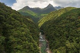
Île de Yakushima, Japon
Yakushima Island
This pretty island in the Osumi archipelago is a UNESCO World Heritage site for its wildlife (deer, macaques...) and lush vegetation, perfect for hiking.

In the Surrounding Area

Climate and Weather

Transportation

Getting There

Getting Around

Accommodation

Food

Useful Addresses

  1. == Further Information
View guide page: Osumi Archipelago

Yakushima Island

This pretty island in the Osumi archipelago is a UNESCO World Heritage site for its wildlife (deer, macaques...) and lush vegetation, perfect for hiking.

Overview of Yakushima Island

This pretty island in the Osumi archipelago is a UNESCO World Heritage site for its wildlife (deer, macaques...) and lush vegetation, perfect for hiking.

Key facts

  • Type of place: island.
  • Tourist interest: (worth seeing).
  • Location:
  • Local time: Heure : 21017
  • Main locality: Yakushima.
  • Population: 13,178 inhabitants (2012).
  • Area: 504.88 km².
  • Highest point: Miyanoura-dake (1,936 m).
  • Coastline:

History of Yakushima Island

Environment of the island

Wildlife and flora

Precautions

What to see and do on Yakushima Island

In the surrounding area

Climate and weather

Transport

Getting there

Getting around

Accommodation

Food

Useful addresses

Further information

View guide page: Yakushima Island

Tokara Islands

A small volcanic archipelago that sees few tourists despite excellent diving opportunities.

Overview of the Tokara Islands

A small volcanic archipelago that sees few tourists despite excellent diving opportunities.

Key Facts

  • Type of place: archipelago.
  • Tourist interest: (worth a stop if you are in the area).
  • Location:
  • Local time: Heure : 21002
  • Number of islands: 12 islands.
  • Main islands: Nakanoshima and Suwanosejima.
  • Population: 784 inhabitants (2016).
  • Area: 101.35 km².
  • Highest point: Mount Ontake (979 m).
  • Coastline:

History of the Tokara Islands

Environment of the Archipelago

Wildlife and Flora

Precautions

What to See and Do in the Tokara Islands

In the Vicinity

Climate and Weather

Transportation

Getting There

Getting Around

Accommodation

Food

Useful Addresses

  1. == Additional Information
View guide page: Tokara Islands

Tsushima

A large mountainous island between Japan and Korea. You can enjoy its landscapes, beaches, and hiking opportunities.

Overview of Tsushima

A large mountainous island between Japan and South Korea. You can enjoy its landscapes, beaches, and hiking opportunities.

Key Facts

  • Type of place: island.
  • Tourist interest: (worth seeing).
  • Location:
  • Local time: Heure : 21003
  • Main locality: Tsushima.
  • Population: 301,005 inhabitants (2018).
  • Area: 708.5 km².
  • Density: 424.85 inhabitants/km².
  • Highest point: Mt. Yatate (648.5 m).
  • Coastline: 915 km.

History of Tsushima

Island Environment

Wildlife and Flora

Precautions

What to See and Do in Tsushima

In the Surroundings

Climate and Weather in Tsushima

Transportation

Getting There

Getting Around

Accommodation

Food

Useful Addresses

Further Information

View guide page: Tsushima

Okinawa Archipelago

An archipelago that, together with the Daito and Sakishima island groups, forms the Ryukyu Islands. Very different from the rest of the country in terms of climate, landscapes, local culture, and architecture, Okinawa and the Ryukyu attract visitors for their beaches and diving. There are also several World War II relics and sites. Overview of the Okinawa Archipelago Climate and Weather in the Okinawa Archipelago What to see in the Okinawa Archipelago Things to Do in the Okinawa Archipelago Flying to the Okinawa Archipelago Getting to the Okinawa Archipelago by Sea Getting Around the Okinawa Archipelago Sleeping and Eating in the Okinawa Archipelago Living in the Okinawa Archipelago

Further Information

View guide page: Okinawa Archipelago

Overview of the Okinawa Archipelago

Overview of the Okinawa Archipelago

This archipelago, which together with the Daito and Sakishima islands forms the Ryukyu Islands, differs greatly from the rest of Japan in terms of climate, landscapes, local culture, and architecture. Okinawa and the Ryukyus also attract visitors for their beaches and diving. There are also several World War II relics and sites.

Key Facts

  • Type of place: archipelago.
  • Tourist interest: (worth seeing).
  • Location:
  • Local time: Heure : 21004.
  • Number of islands:
  • Main island: Okinawa Island (1,201 km², population 1.23 million)
  • Population: 1,285,003 inhabitants (2013).
  • Area: 1,418.59 km².
  • Highest point: Mount Yonaha-dake (503 m) on Okinawa.

History of the Okinawa Archipelago

Precautions

Useful Addresses

View guide page: Overview of the Okinawa Archipelago

Climate and Weather in the Okinawa Archipelago

Climate Overview

Best Time to Visit the Okinawa Archipelago

Jan.Feb.Mar.Apr.MayJun.Jul.Aug.Sep.Oct.Nov.Dec.
Climate

Climate and Forecasts

Further Information

View guide page: Climate and Weather in the Okinawa Archipelago

What to see in the Okinawa Archipelago

Overview

UNESCO Heritage

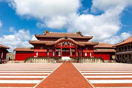
Châteaux de l'archipel d'Okinawa, Japon
Okinawa Archipelago Castles
This collection of structures, officially known as the "Gusuku Sites of the Ryukyu Kingdom," spans five centuries of the archipelago to which Okinawa belongs. The site is a UNESCO World Heritage listing.

Cities and cultural heritage

Natural heritage

In the surrounding area

Further reading

View guide page: What to see in the Okinawa Archipelago

Okinawa Archipelago Castles

This collection of structures, officially known as the "Gusuku Sites of the Ryukyu Kingdom," spans five centuries of the archipelago to which Okinawa belongs. The site is a UNESCO World Heritage listing.

Overview of Okinawa Castles

This collection of structures, officially known as "Gusuku Sites of the Ryukyu Kingdom", spans five centuries of the archipelago to which Okinawa belongs. The site is a UNESCO World Heritage listing.

  • Tourist interest: (worth seeing).

History of Okinawa Castles

What to see and do

Practical information

  • Location:
  • Local time: Heure : 21004.
  • Opening hours:
  • Admission fee:

Transport

Accommodation and dining

Nearby attractions

  1. == En complément
View guide page: Okinawa Archipelago Castles

Flying to the Okinawa Archipelago

Okinawa Archipelago Airport

The archipelago has an airport located on Okinawa Island, in the south of the island near Naha.

Airport details

  • Name: Naha Airport.
  • IATA code: OKA
  • Hub:
  • Number of terminals: 3.
  • Annual passenger capacity:
  • Passenger traffic: 18,336,030 (2015).
  • Distance to city centre:

Services

Sleeping at the airport

Transport to the city centre

Other nearby airports

From the rest of the country

From the rest of Asia-Pacific

Additional information

View guide page: Flying to the Okinawa Archipelago

Mount Aso

This is the largest and one of the most active volcanoes in the country. Located within Aso-Kuju National Park, it offers hiking opportunities and hot springs.

Overview of Mount Aso

This is the largest and one of the most active volcanoes in Japan. Located within Aso-Kuju National Park, it offers hiking opportunities and hot springs.

Key details

  • Type of place: volcano.
  • Tourist interest: (worth seeing).
  • Features:
  • Massif:
  • Summit: 1,592 m.

Mount Aso's environment

Wildlife and flora

Climate and weather

Precautions

What to see and do

Practical information

  • Location:
  • Distances:

Getting there

Accommodation and dining

Nearby attractions

Additional information

View guide page: Mount Aso

Kirishima-Yaku National Park

In the south of the island, volcanoes, waterfalls, hot springs, and forests to hike through. The park is actually split into two areas: the region around the cities of Kirishima and Kagoshima on Kyushu, and Yakushima in the Osumi archipelago.

Overview of Kirishima-Yaku Park

In the south of Kyushu Island, volcanoes, waterfalls, hot springs, and forests to hike through. The park is actually split into two areas: the region around the cities of Kirishima and Kagoshima on Kyushu, and Yakushima in the Osumi Archipelago.

Key facts

  • Type of place: national park.
  • Tourist interest: (worth seeing).
  • Features:
  • Local time: Heure : 21006
  • Annual visitors:
  • Area: 548.33 km².
  • Altitude:

Environment

Landscape of the park

Wildlife and flora

Climate and weather

Precautions

What to see and do

Practical information

  • Location:
  • Distances:
  • Opening period:
  • Rates:

Getting there

Getting around

Accommodation and dining

What to see nearby

Further reading

View guide page: Kirishima-Yaku National Park

Unzen-Amakusa National Park

It comprises the Mount Unzen volcano and the Amakusa islands. You can hike there or enjoy the beaches of Amakusa.

Overview of Unzen-Amakusa Park

It comprises the Mount Unzen volcano and the Amakusa islands. You can hike there or enjoy the beaches of Amakusa.

Key details

  • Type of place: national park.
  • Tourist interest: (worth seeing).
  • Features:
  • Local time: Heure : 21007
  • Annual visitors:
  • Area: 282.79 km².
  • Altitude:

Environment

Park landscape

Wildlife and flora

Climate and weather

Precautions

What to see and do

Practical information

  • Location:
  • Distances:
  • Opening period:
  • Rates:

Getting there

Getting around

Accommodation and dining

Nearby attractions

Additional information

View guide page: Unzen-Amakusa National Park

Something wrong or out of date? Report this page