
Skip to content
Regions of Namibia

Travel guide · Namibia

Regions of Namibia

last edited Jan 8, 2020 · 2 versions

The Coast

Côte des Squelettes, Namibie

Namibia has over 1,500 km of coastline, which is not particularly hospitable. The coast is part of the Namib Desert, with only a few main towns built by German colonisers at the end of the 19th century, most of which have retained a very specific architecture.

For travellers, this part of the country is well worth a visit, with natural sites like Cape Cross (and its seals), the Brandberg massif (for hiking), and above all the Namib-Naukluft National Park, internationally renowned for the Sesriem Canyon and the orange dunes of Sossusvlei and Deadvlei, which are the country’s top tourist attraction.

The Interior

Parc national d'Etosha, Namibie

This vast region, centred on a high plateau over 2,000 m above sea level, is home to the capital, Windhoek, and beyond it the expansive Kalahari Desert. Sparsely populated outside the capital, it’s a land of adventure and discovery, with many points of interest, chief among them the Etosha National Park and its hundreds of species of African wildlife.
Namibia's Atlantic Coast

Namibia boasts over 1,500 km of coastline, though it’s far from the most hospitable. Part of the Namib Desert, the coast features key towns built by German colonizers in the late 19th century, many of which retain a distinct architectural style.…

Read the full guide: Namibia's Atlantic Coast

Namibia's Interior

This vast region, centered around a high plateau exceeding 2,000 m, is home to the capital, Windhoek, and beyond it, the expansive Kalahari Desert. Sparsely populated outside the capital, it’s a land of adventure and discovery, with numerous attractions, chief among them Etosha National Park and its hundreds of species of wild African wildlife.

Overview

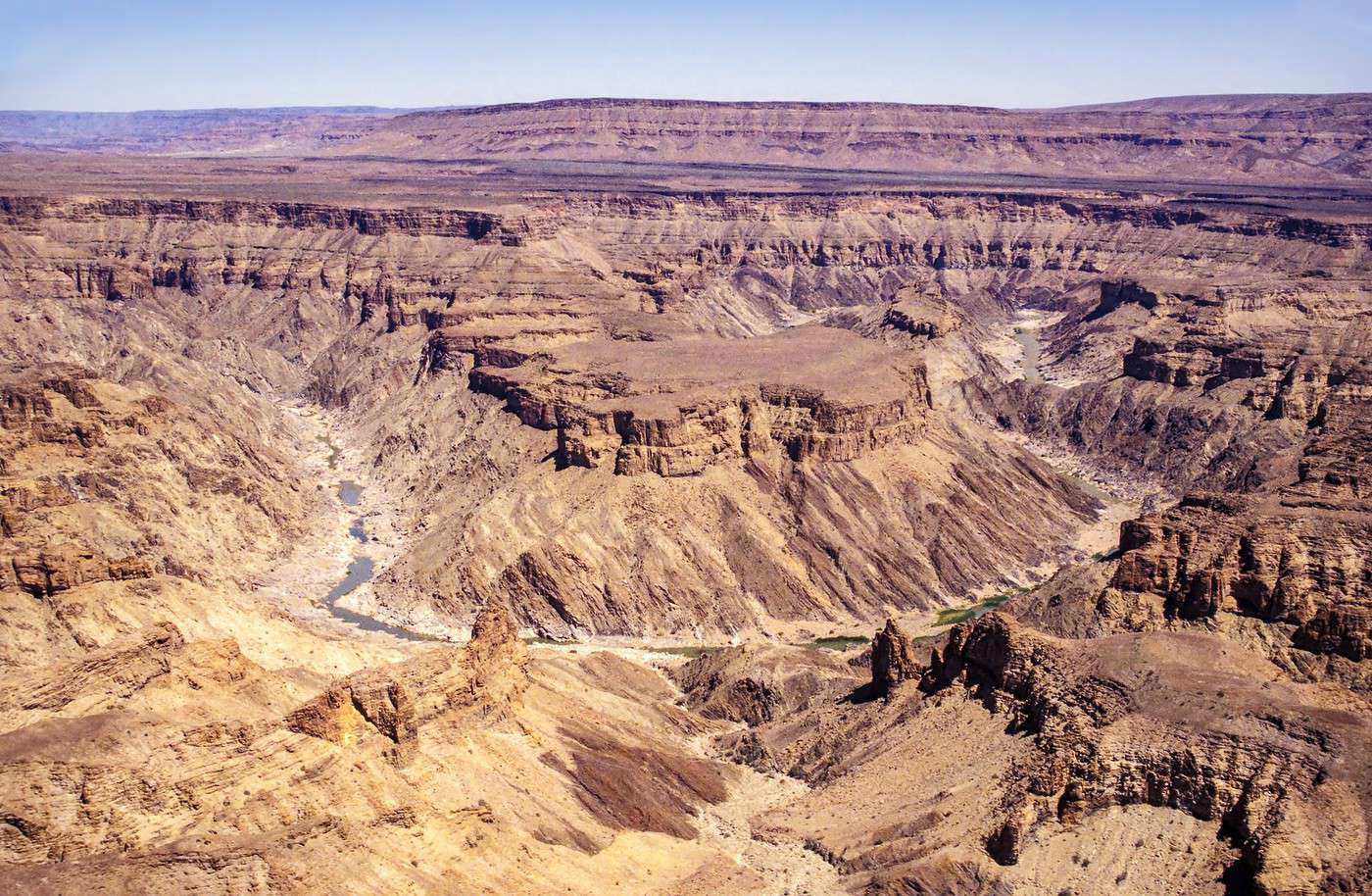
Canyon de la Fish River, Namibie
Canyon de la Fish River, Namibie · © VoyageForum

This vast region, centered around a high plateau exceeding 2,000 m, is home to the capital, Windhoek, and beyond it, the expansive Kalahari Desert. Sparsely populated outside the capital, it’s a land of adventure and discovery, with numerous attractions, chief among them the Etosha National Park and its hundreds of species of wild African wildlife.

Major Cities

Tourist Attractions

Cities and Their Heritage

Nature and Activities

Climate and Weather

The climate can be characterized by two seasons, with variations depending on the location and significant day/night temperature swings inland.

From late October to early April, during the southern summer, the country experiences its rainy season. This brings scorching heat (and cool nights) inland, while temperatures are more pleasant along the coast and in mountainous areas. The further south you go, the less pronounced the rainy season becomes. Winter, from May to early October, is the dry season. Temperatures are cooler, and nights can be cold, especially on the high plateaus.

Best Climate Period for the Interior

The best time to visit climatically is between April and September-October. This is when you can fully enjoy the interior and national parks, some of which (including Etosha) are closed at the start and end of the year.

Jan.Feb.Mar.Apr.MayJun.Jul.Aug.Sep.Oct.Nov.Dec.
Interior Climate

: very favorable | : favorable | : moderately favorable | : unfavorable.

Climate in Windhoek

View guide page: Namibia's Interior

Windhoek

Namibia’s capital and largest city, situated at 1,700 m above sea level. It retains a number of architectural traces of its colonial past. Nearby, the Daan Viljoen Game Reserve offers hiking trails to discover local wildlife. Overview of Windhoek Windhoek Climate and Weather What to See in Windhoek Things to Do in Windhoek Flying to Windhoek Getting to Windhoek by Land Getting Around Windhoek Sleeping and Eating in Windhoek Living in Windhoek

Further Information

View guide page: Windhoek

Overview of Windhoek

Overview of Windhoek

It is the capital and main city of Namibia, at an altitude of 1,700 m. It retains a number of architectural traces of its colonial past. Nearby, Daan Viljoen Reserve offers wildlife discovery via hiking trails.

Key Facts

  • Type of place: large city.
  • Tourist interest: (worth seeing).
  • Location:
  • Distances:
  • Local time: Heure : 6225.
  • Population: 325,858 inhabitants (2011).
  • Area: 5,133 km².
  • Altitude: 1,655 m.

History of Windhoek

Precautions

Useful Addresses

  • Tourist Office:

Services

  • Local agencies:
  • Banks:
  • Hospital:
  • Internet:
  • Laundries:
  • Vehicle rental:
  • Post office:
View guide page: Overview of Windhoek

Windhoek Climate and Weather

Climate Overview

Best Time to Visit Windhoek

Jan.Feb.Mar.Apr.MayJun.Jul.Aug.Sep.Oct.Nov.Dec.
Climate

Climate and Forecast

Additional Information

View guide page: Windhoek Climate and Weather

What to See in Windhoek

Overview

Neighborhoods

Sites, Monuments, and Architectural Ensembles

Religious Buildings

Museums

Parks and Gardens

In the Surrounding Area

  1. == In Addition
View guide page: What to See in Windhoek

Flying to Windhoek

Windhoek Airport

Airport details

  • Name: Hosea Kutako International Airport.
  • IATA code: WDH
  • Hub:
  • Number of terminals: 1.
  • Annual passenger capacity:
  • Passenger traffic: 1,574,148 (2016).
  • Distance from city centre: 45 km east of the city.
  • Website:

Services

Sleeping at the airport

Transport to the city centre

Other nearby airports

From the rest of Africa

From Europe

From elsewhere

Additional information

View guide page: Flying to Windhoek

Gobabis

Primarily a stopover town between Botswana (or South Africa) and Windhoek on the Trans-Kalahari Highway.

Overview of Gobabis

Primarily a stopover town between Botswana (or South Africa) and Windhoek on the Trans-Kalahari Highway.

Key Facts

  • Type of place: small town.
  • Tourist interest: (worth a stop if you are in the area).
  • Location:
  • Distances:
  • Local time: Heure : 6237.
  • Population: 19,101 inhabitants (2011).
  • Area:
  • Altitude: 1,440 m.

History of Gobabis

What to see and do in Gobabis

In the surrounding area

Climate and weather in Gobabis

Transport

Getting there

Getting around

Accommodation

Eating

Useful addresses

Further information

View guide page: Gobabis

Grootfontein

A small town in the northeast with partly colonial architecture and an old fortress. A few kilometres away, you can see one of the largest meteorites ever to fall to Earth.

Overview of Grootfontein

This is a small town in the northeast of Namibia with partly colonial architecture and an old fortress. A few kilometres away, you can see one of the largest meteorites ever to fall to Earth.

Key facts

  • Type of place: small town.
  • Tourist interest: (worth a stop if you are in the area).
  • Location:
  • Distances:
  • Local time: Heure : 6238.
  • Population: 23,793 inhabitants (2011).
  • Area:
  • Altitude: 1,460 m.

History of Grootfontein

What to see and do in Grootfontein

In the surrounding area

Climate and weather in Grootfontein

Transport

Getting there

Getting around

Accommodation

Food

Useful addresses

Further information

View guide page: Grootfontein

Kaokoland

This former Bantustan in the north of the country, extending into Angola, is the territory of the Himba and Herero peoples, whose traditions remain very much alive. It is above all an isolated, semi-mountainous, and partly desert region where herds of elephants roam.

Overview of Kaokoland

This former Bantustan in the north of Namibia, extending into Angola, is the territory of the Himba and Herero peoples, whose traditions remain very much alive. It is above all an isolated, semi-mountainous, and partly desert region where herds of elephants roam.

Key Facts

  • Type of place: secondary tourist region.
  • Tourist interest: (worth seeing).
  • Location:
  • Local time: Heure : 6239
  • Main town: Opuwo (7,600 inhabitants).
  • Population: 16,000 inhabitants (2011)
  • Area: 48,982 km².
  • Highest point:
  • Lowest point:
  • Coastline: no maritime access.

Climate and Weather

Main Towns

Tourist Attractions

Towns and Heritage

Nature and Activities

Transport

Getting There

Getting Around

Accommodation

Food

Further Information

View guide page: Kaokoland

Keetmanshoop

A small town in the south with German colonial remnants, Keetmanshoop is primarily a base for visitors exploring the surrounding areas (Fish River Canyon, Quiver Tree Forest, Giant's Playground rocks).

Overview of Keetmanshoop

A small town in the south with German colonial remnants, Keetmanshoop is primarily a base used by visitors to explore the surrounding areas (Fish River Canyon, Quiver Tree Forest, Giant's Playground rocks).

Key Facts

  • Type of place: small town.
  • Tourist interest: (worth a stop if you are in the area).
  • Location:
  • Distances:
  • Local time: Heure : 6240.
  • Population: 20,977 inhabitants (2011).
  • Area:
  • Altitude:

History of Keetmanshoop

What to see and do in Keetmanshoop

In the surrounding area

Climate and weather in Keetmanshoop

Transportation

Getting there

Getting around

Accommodation

Dining

Useful addresses

Additional information

View guide page: Keetmanshoop

Opuwo

This small town of fewer than 10,000 people is the capital of Kaokoland. It’s typically used as a base for exploring the nearby Himba and Herero villages.

Overview of Opuwo

This small town of fewer than 10,000 people is the capital of Kaokoland. It’s typically used as a base for exploring the nearby Himba and Herero villages.

Key details

  • Type of place: small town.
  • Tourist interest: (worth a stop if you are in the area).
  • Location:
  • Distances:
  • Local time: Heure : 6241.
  • Population: 7,657 inhabitants (2011).
  • Area:
  • Altitude: 1,300 m.

History of Opuwo

What to see and do in Opuwo

In the surrounding area

Climate and weather in Opuwo

Transport

Getting there

Getting around

Accommodation

Eating

Useful addresses

Further information

View guide page: Opuwo

Otjiwarongo

The small town in north-central Namibia typically serves as a starting point for exploring the Waterberg Plateau.

Overview of Otjiwarongo

The small town in north-central Namibia typically serves as a starting point for exploring the Waterberg Plateau.

Key Facts

  • Type of place: small town.
  • Tourist interest: (worth a stop if you are in the area).
  • Location:
  • Distances:
  • Local time: Heure : 6242.
  • Population: 28,249 inhabitants (2011).
  • Area:
  • Altitude: 1,460 m.

History of Otjiwarongo

What to See and Do in Otjiwarongo

In the Surrounding Area

Climate and Weather in Otjiwarongo

Transportation

Getting There

Getting Around

Accommodation

Dining

Useful Addresses

Additional Information

View guide page: Otjiwarongo

Outjo

This town in northern Namibia is considered the gateway to Etosha National Park.

Overview of Outjo

This town in northern Namibia is considered the gateway to Etosha National Park.

Key Facts

  • Type of place: village.
  • Tourist interest: (worth a stop if you are in the area).
  • Location:
  • Distances:
  • Local time: Heure : 6243.
  • Population: 8,445 inhabitants (2011).
  • Area:
  • Altitude: 1,216 m.

History of Outjo

What to See and Do in Outjo

In the Surrounding Area

Climate and Weather in Outjo

Transport

Getting There

Getting Around

Accommodation

Food

Useful Addresses

  1. == Additional Information
View guide page: Outjo

Rundu

"Large" town on the Angolan border, its main tourist appeal lies in the Okavango River, which can be explored by canoe, as well as birdwatching in the surrounding area.

Overview of Rundu

A "large" town on the Angolan border, its main tourist appeal lies in the Okavango River, which can be explored by canoe, as well as birdwatching in the surrounding area.

Key Facts

  • Type of place: city.
  • Tourist interest: (worth a stop if you are in the area).
  • Location:
  • Distances:
  • Local time: Heure : 6244.
  • Population: 63,431 inhabitants (2011).
  • Area: 164.1 km².
  • Altitude: 1,095 m.

History of Rundu

What to See and Do in Rundu

In the Surrounding Area

Climate and Weather in Rundu

Transportation

Getting There

Getting Around

Accommodation

Food

Useful Addresses

Further Information

View guide page: Rundu

Caprivi Strip

This "panhandle" juts about 500 km into Botswanan territory, averaging 30 km in width. The largely marshy area is rich in minerals and wildlife (elephants, hippos, birds), which can be observed in several parks, including Caprivi Game Park, Mamili, Mahango, and Mudumu National Park.

Overview of the Caprivi Strip

This "panhandle" juts about 500 kilometres into Botswanan territory, averaging 30 kilometres in width. The largely marshy area is rich in minerals and wildlife (elephants, hippos, birds), which can be observed in several parks, including Caprivi Game Park, Mamili, Mahango, and Mudumu National Park.

Key Facts

  • Type of place: secondary tourist region.
  • Tourist interest: (worth seeing).
  • Location:
  • Local time: Heure : 6246
  • Main town:
  • Population: around 150,000 inhabitants.
  • Area: 20,009 km².
  • Highest point:
  • Lowest point:
  • Coastline: no maritime access.

Climate and Weather

Main Towns

Tourist Attractions

Towns and Heritage

Nature and Activities

Transport

Getting There

Getting Around

Accommodation

Food

Further Information

View guide page: Caprivi Strip

Daan Viljoen Reserve

A small reserve right next to Windhoek where you can explore wildlife via hiking trails.

Overview of Daan Viljoen Reserve

This is a small reserve right next to Windhoek where you can explore wildlife via hiking trails.

Key Details

  • Type of place: nature reserve.
  • Tourist interest: (worth a stop if you are in the area).
  • Features:
  • Local time: Heure : 6247
  • Annual visitors:
  • Area: 40 km².
  • Altitude:

Environment

Landscape of the Reserve

Wildlife and Flora

Climate and Weather

Precautions

What to See and Do

Practical Information

  • Location:
  • Distances:
  • Opening period:
  • Rates:

Getting There

Getting Around

Sleeping and Eating

Nearby Attractions

  1. == In Addition
View guide page: Daan Viljoen Reserve

Damaraland

A desert region in north-central Namibia where herds of elephants and rhinos can be seen.

Overview of Damaraland

Damaraland is a desert region located in north-central Namibia where herds of elephants and rhinos can be seen.

Key Facts

  • Type of place: secondary tourist region.
  • Tourist interest: (worth seeing).
  • Location:
  • Local time: Heure : 6248
  • Main town: Khorixas.
  • Population:
  • Area: 47,990 km².
  • Highest point: Königstein (2,573 m).
  • Lowest point:
  • Coastline: no maritime access.

Climate and Weather

Main Towns

Tourist Attractions

Towns and Heritage

Nature and Activities

Transport

Getting There

Getting Around

Accommodation

Food

Further Information

View guide page: Damaraland

Epupa Falls

A series of waterfalls on the border between Angola and Namibia. Also worth seeing are similar falls further east at Ruacana Falls.

Overview of Epupa Falls

A series of waterfalls on the border between Angola and Namibia. Also worth seeing are similar falls further east at Ruacana Falls.

Key Details

  • Type of place: waterfall.
  • Tourist interest: (worth seeing).
  • Features:
  • Height: 37 m (for the largest drop).
  • Altitude:

Site Environment

Climate and Weather

Precautions

What to See and Do

Practical Information

  • Location:
  • Distances:

Getting There

Sleeping and Eating

Nearby Attractions

Further Reading

View guide page: Epupa Falls

Etosha National Park

Not far from the Angolan border, this is one of the country's most visited places. It's home to a wide range of wildlife, including lions, elephants, rhinos, giraffes, zebras, gazelles, birds, and more. Overview of Etosha National Park Climate and Weather in Etosha National Park What to see and do in Etosha National Park Practical information for Etosha National Park

Further information

View guide page: Etosha National Park

Overview of Etosha National Park

Overview

Not far from the Angolan border, this is one of the most visited places in Namibia. It’s home to a wide range of wildlife, including lions, elephants, rhinos, giraffes, zebras, gazelles, birds, and more.

Key details

  • Type of place: major national park.
  • Tourist interest: (must-see or highly recommended).
  • Features:
  • Location:
  • Distances:
  • Local time: Heure : 6251
  • Annual visitors:
  • Area: 22,270 km².
  • Altitude:

Environment

Landscape of the park

Wildlife and vegetation

Precautions

View guide page: Overview of Etosha National Park

Climate and Weather in Etosha National Park

Climate Overview

Best Time to Visit

Jan.Feb.Mar.Apr.MayJun.Jul.Aug.Sep.Oct.Nov.Dec.
Climate

: very favourable | : favourable | : moderately favourable | : unfavourable.

Climate and Forecasts

Further Information

View guide page: Climate and Weather in Etosha National Park

Practical information for Etosha National Park

Practical info

  • Opening period:
  • Rates:

Transport

Getting there

Distances

Getting around

Sleep

Eat

View guide page: Practical information for Etosha National Park

Fish River Canyon

It's the second-largest canyon in the world and the second-most visited site in Namibia thanks to its trekking opportunities. The Ai-Aïs hot springs can be seen in the south of the park.

Overview of Fish River Canyon

It's the second-largest canyon in the world and the second-most visited site in Namibia thanks to its trekking opportunities. The Ai-Aïs hot springs can be seen in the south of the park.

Key facts

  • Type of place: canyon.
  • Tourist interest: (must-see or highly recommended).
  • Features:
  • Local time: Heure : 6252
  • Annual visitors:
  • Area: 5,900 km².
  • Altitude:

Environment

Site features

Wildlife and vegetation

Climate and weather

Precautions

What to see and do

Practical information

  • Location:
  • Distances:
  • Opening period:
  • Rates:

Transport

Getting there

Getting around

Sleep

Eat

Nearby attractions

Additional information

View guide page: Fish River Canyon

Khaudom Reserve

Located on the border with Botswana, in the Kalahari, this hard-to-reach park is quite rich in wildlife, including lions, elephants, and giraffes. It is also home to the San people.

Overview of Khaudom Reserve

Located on the border with Botswana, in the Kalahari, this hard-to-reach park is quite rich in wildlife, including lions, elephants, and giraffes. It is also home to the San people.

Key details

  • Type of place: nature reserve.
  • Tourist interest: (worth seeing).
  • Features:
  • Local time: Heure : 6253
  • Annual visitors:
  • Area: 7,800 km².
  • Altitude:

Environment

Landscape of the reserve

Wildlife and vegetation

Climate and weather

Precautions

What to see and do

Practical information

  • Location:
  • Distances:
  • Opening period:
  • Rates:

Getting there

Getting around

Sleeping and eating

What to see nearby

Further reading

View guide page: Khaudom Reserve

Okavango

Between its source in Angola and its delta in Botswana, the Okavango flows through northern Namibia, partly forming the border between Namibia and Angola. Near the town of Rundu, the river offers opportunities for canoeing and birdwatching.

Overview of the Okavango

Between its source in Angola and its delta in Botswana, the Okavango flows through northern Namibia, partly forming the border between the latter and Angola. Near the town of Rundu, the river offers opportunities for canoeing and birdwatching.

Key facts

  • Type of place: river.
  • Tourist interest: (worth a stop if you are in the area).
  • Features:
  • Length: 1,700 km.
  • Altitude:

Environment

What to see and do

Practical information

  • Location:

Getting there

Accommodation and dining

What to see nearby

Further reading

View guide page: Okavango

Ruacana Falls

Like Epupa, these are falls located on the border between Namibia and Angola. Nearby, you can also go rafting on the Kunene River.

Overview of Ruacana Falls

Like Epupa, these are falls located on the border between Namibia and Angola. Nearby, you can also go rafting on the Kunene River.

Key details

  • Type of place: waterfall.
  • Tourist interest: (worth seeing).
  • Features:
  • Height: 120 m.
  • Altitude:

Site environment

Climate and weather

Precautions

What to see and do

Practical information

  • Location:
  • Distances:

Getting there

Sleeping and eating

What to see nearby

Further information

View guide page: Ruacana Falls

Twyfelfontein

Comprising scattered rocks in a desert environment, this UNESCO-listed rock art site is located a few kilometres from the Petrified Forest of Damaraland.

Overview of Twyfelfontein

Comprising scattered rocks in a desert environment, this UNESCO-listed rock art site is located a few kilometres from the Petrified Forest of Damaraland.

  • Tourist interest: (worth seeing).

History of Twyfelfontein

What to see and do

Practical information

  • Location:
  • Local time: Heure : 6256.
  • Address: Namibia.
  • Opening hours:
  • Price:

Transport

Accommodation and dining

Nearby attractions

Additional information

View guide page: Twyfelfontein

Waterberg National Park

In the northern part of Namibia, this small, somewhat hard-to-reach park is home to many bird species, as well as rhinos and antelopes. Trekking is available here.

Overview of Waterberg Park

In the northern part of Namibia, this small, somewhat hard-to-reach park is home to many bird species, as well as rhinos and antelopes. Trekking is available here.

Key details

  • Type of place: national park.
  • Tourist interest: (worth seeing).
  • Features:
  • Local time: Heure : 6257
  • Annual visitors:
  • Area: 405 km².
  • Altitude:

Environment

Landscape of the park

Wildlife and vegetation

Climate and weather

Precautions

What to see and do

Practical information

  • Location:
  • Distances:
  • Opening period:
  • Rates:

Getting there

Getting around

Accommodation and dining

Nearby attractions

Additional information

View guide page: Waterberg National Park

Tsumeb

A pleasant mining town in the north with a museum dedicated to this industry.

Overview of Tsumeb

It's a pleasant mining town in northern Namibia with a museum dedicated to this industry.

Key Information

  • Type of place: small town.
  • Tourist interest: (worth a stop if you are in the area).
  • Location:
  • Distances:
  • Local time: Heure : 27264.
  • Population: 19,275 inhabitants (2011).
  • Area:
  • Altitude: 1,249 m.

History of Tsumeb

What to See and Do in Tsumeb

In the Surrounding Area

Climate and Weather in Tsumeb

Transportation

Getting There

Getting Around

Accommodation

Dining

Useful Addresses

Additional Information

View guide page: Tsumeb

Something wrong or out of date? Report this page