Join me in discovering Gran Canaria
FR

Translated into English.

PI Pinacoladada Globetrotter ·
ARUCAS

28.11807, -15.52222 Parking 28.11902, -15.52284 San Juan Plaza 28.11824, -15.52303 Parque de la Paz and its neo-Gothic church 28.11787, -15.52328 Plaza del Pintor Guillermo Sureda 28.11846, -15.52387 Plaza del Doctor Joaquín Blanco - Casa de la Cultura 28.11902, -15.52476 Plaza de la Constitución 28.11953, -15.52610 Parque Municipal 28.11924, -15.52643 Heredad de Aguas de Arucas y Firgas 28.11969, -15.52911 Arehucas Rum Distillery and Museum

Located in the north of the island, the old town of Arucas was completely rebuilt after the fire of 1478 during the Spanish conquest.

At the end of the 19th century, the town was awarded the distinction of historical-artistic interest. Its economy was initially based on cochineal farming and later on banana cultivation.

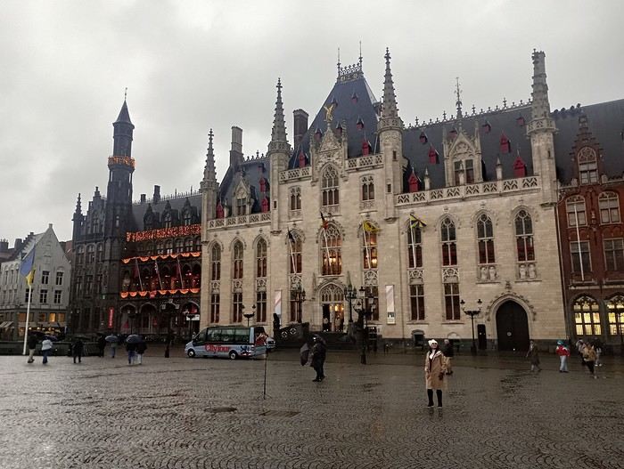
At the heart of this heritage stands the monumental San Juan Bautista Church, built in the neo-Gothic style, which was granted cathedral status in the early 20th century.

It’s an ideal starting point for exploring the old town by strolling through its cobbled streets to admire the traditional architecture and discover charming historic buildings.

Plaza del Pintor Guillermo Sureda is a very pretty square located right in front of the cathedral.

Plaza del Doctor Joaquín Blanco is a small square at the junction of León y Castillo and Gourié streets, where you’ll find a bust of the poet Domingo Rivero, one of the major literary figures of the Canary Islands, as well as a 17th-century building that now houses the Casa de la Cultura. This cultural center features an inner courtyard with a magnificent dragon tree.

After walking along León y Castillo street, you’ll reach Plaza de la Constitución, where the Town Hall and traditional Canarian buildings are located.

It’s on this square that a sign with the town’s name was erected, making it a great spot for some lovely photos.

Parque Municipal de Arucas is a pleasant green space to relax, with fountains, sculptures, and playgrounds.

The Heredad de Aguas de Arucas y Firgas building catches visitors' attention with its impressive architecture, featuring a façade made of local stone and a tower topped with a dome adorned with a German clock dating back to 1913.

The Heredad de Aguas de Arucas y Firgas is an institution created in 1505 to control and manage water rights in part of the northern area of Gran Canaria.

On our way to the Arehucas Rum Distillery and Museum, we passed by the Ermita de San Pedro, a small religious building dating back to 1724. It was restored in the 1970s by the distillery, which now owns it.

The distillery and its museum are housed in a 19th-century factory. Visits are allowed from Monday to Friday, offering the chance to taste their products and learn more about the rum-making process. Unfortunately, it was closed when we visited.

https://youtu.be/O5R1p5hqin0
PI Pinacoladada Globetrotter ·
FIRGAS

28.10795, -15.56311 Belvedere 28.10776, -15.56247 Frog Fountain 28.10735, -15.56290 Plaza San Roque and its church 28.10749, -15.56255 Paseo de Gran Canaria (Promenade) 28.10718, -15.56295 Paseo de Canarias with its 22 heraldic shields 28.10682, -15.56260 Parque del Ganadero

Firgas is a charming little village in the north of the island, known for the quality of its mineral water.

Its historic center stands out with a lovely 30-meter artificial waterfall flowing along the former calle Real (Paseo de Gran Canaria), as well as mosaics representing the Canary Islands and beautiful ceramic benches (Paseo de Canarias).

The Casa de la Cultura (House of Culture) is probably the most iconic building in Firgas. Built in 1870, it once housed a hotel. Today, it’s home to the municipal library, an exhibition hall, and an assembly room.

Plaza de San Roque, where the church is located, offers a panoramic view of the ocean and the north of the island. The Church of San Roque features typical Canarian architecture with its white walls and basalt stones. Its coffered ceiling is a true masterpiece.

Near the church, you’ll find the Acequia Real de La Heredad de Aguas de Arucas y Firgas, an old water canal restored in 2009. A sculpture of two hands washing laundry pays tribute to all the washerwomen who worked there.

Firgas Town Hall is a lovely building inspired by traditional Canarian architecture, constructed in the 1940s.

Parque del Ganadero is a peaceful little park that also offers a panoramic view of the northern coast. It features a stone sculpture by José Luis Marrero Cabrera, inaugurated on August 14, 1998, depicting the rancher Don Pedro Alemán Montesdeoca with a cow.

This sculpture honors all those who, through their hard work and sacrifices, promoted agriculture and livestock farming, boosting the economic growth of the municipality.

Another attraction in Firgas is a pretty fountain that also serves as a roundabout in the middle of the main road. It’s surrounded by small sculptures of frogs.

https://youtu.be/_k24-DQYeJ0
PI Pinacoladada Globetrotter ·
MOYA

28.11098, -15.58416 Plaza la Candelaria and its church 28.11085, -15.58448 Mirador 28.11076, -15.58366 Casa-Museo Tomás Morales 28.10920 -15.583045 Heredad de Aguas de Moya 28.10920, -15.58370 Cementerio Municipal 28.10968, -15.58398 Plaza de la Concordia

Moya is a charming town located in the north of the island, known for its historical heritage and peaceful atmosphere.

As you wander through its streets, you’ll discover a rich architectural heritage and breathtaking landscapes.

While strolling through Moya, you can’t miss the town’s iconic buildings. Among them, highlights include the Church of Our Lady of Candelaria, the Casa Museo Tomás Morales (Tomás Morales House Museum), the Heredad de Aguas (organization responsible for managing irrigation water), and the Hermitage of San Bartolomé de Fontanales.

The Church of Our Lady of Candelaria, inaugurated in 1957, was built on the rocks of the Moya ravine. It’s divided into three naves, with two attached towers, and features a large rose window on its main façade. Inside, it’s adorned with magnificent stained glass.

Behind the church, you’ll enjoy a stunning view of the ravine and the island’s peaks.

Opposite the church is the Casa Museo, the birthplace of poet Tomás Morales, who was born in this town in 1884. A large collection of his legacy is preserved there.

The Heredad de Aguas building stands out with its six neoclassical columns and a tower topped with a bell tower and clock.

You’ll also find a lovely fountain in the middle of a roundabout in front of the Bar-Cafetería Los Tilos, whose main façade is quite charming.

The municipal cemetery, which is very well maintained, is located in a unique spot. Next to the cemetery is the Plaza de la Concordia, offering a breathtaking view of the church and the ravine.

https://youtu.be/fywroDLLdck
PI Pinacoladada Globetrotter ·
SANTA MARIA DE GUIA

28.13937, -15.63300 Plaza Grande and its church 28.13905, -15.63321 Casa Quintana 28.13900, -15.63280 Plaza Luján Pérez 28.13935, -15.63219 Néstor Álamo Museum 28.13981, -15.63185 Casa de la Cultura 28.13880, -15.63074 Ermita de San Antonio 28.13743 -15.62995 Ermita de San Roque 28.13693, -15.62964 Plaza Sor Lorenza Díaz Bolaños

Santa Maria de Guia is a small town located in the north of the island. Its historic center was declared a National Historic and Artistic Monument in 1982.

It’s pleasant to stroll through its narrow streets lined with traditional, colorful Canarian houses.

The Church of Santa María de Guía overlooks Plaza Grande. It’s a magnificent example of 16th-century religious architecture. Its façade is neoclassical and flanked by two lateral towers. It houses important works of art.

Casa de la Quintana, or Casa de Los Quintana, is an old Canarian residence from the 16th century located near the church. Its wooden balcony is said to be the original one.

The building housing the Town Hall is also very pretty.

The Néstor Álamo Museum is located in a 17th-century residence. It’s dedicated to this Canarian writer, composer, and journalist.

Casa de la Cultura is tucked away in a small alley and isn’t very visible. It’s housed in a building that blends traditional and functional architecture to accommodate the town’s cultural activities.

Higher up in the town, you can visit the Ermita de San Roque, located on the square of the same name. It’s surrounded by beautiful colorful houses. Along the way, you can also spot the old Ermita de San Antonio.

You’ll also find Plaza Sor Lorenza Díaz Bolaños, which has been renovated to create recreational spaces and give it a modern urban look. It’s equipped with sports facilities to promote outdoor activities.

https://youtu.be/ck8xsUq4cDM
PI Pinacoladada Globetrotter ·
GÁLDAR

28.14475, -15.65831 La Quinta Parking (free between 1pm and 4pm - 1 euro for 5 hours) 28.14463, -15.65771 Calle Guaires 28.14499, -15.65543 Plaza de Santiago and its church 28.14435, -15.65519 Statue of Arminda (Guanche Princess) 28.14442, -15.65539 Teatro Consistorial de Gáldar 28.14538, -15.65481 Calle Capitán Quesada 28.14501, -15.65463 Plaza de los Faycanes 28.14562, -15.65470 Casa-Museo Antonio Padrón 28.14338, -15.65381 Plaza del Cristo

Gáldar is a picturesque town in the northwest of the island. The streets of its historic center are lined with brightly colored houses featuring pretty balconies.

Starting from the parking lot, we took Calle Guaires and passed by the Juan Vega Mateos Sports Center. In front of this building, there’s a monument paying tribute to fighters.

Nearby is the recently renovated cultural center. On the opposite side, you can see an old façade with a cross at the top. It’s indicated that this structure dates back to 1832.

As we continued our walk down this road, we spotted some lovely sculptures depicting the daily life of warriors.

Among them, you’ll see men sitting in front of a game of *La Chascona*, representing their strategy to defeat opponents, as well as a man with a goat, reflecting one of their main sources of income.

Statues of three other figures stand nearby. One man stands out from the group, a dagger in his back. This scene symbolizes the Castilian conquest.

We made our way to the church (Iglesia de Santiago de los Caballeros), in front of which there’s a pretty fountain. Its architecture is a mix of neoclassical and baroque styles, and its main façade is flanked by two towers—one housing a clock and the other, bells.

Plaza de Santiago is lush and green, and the nearby alleys feature very pretty historic homes, including the Casino de Gáldar. This isn’t a gambling hall but rather a non-profit social association dating back to 1847, promoting education and leisure.

In front of the Casino de Gáldar stands the statue of Esteban Ruíz de Quesada. This noble military captain, a native of the town, is known for being the promoter and founder of the church in the historic center.

The buildings housing the Teatro Consistorial de Gáldar and the Casas Consistoriales del Ayuntamiento de Gáldar are also worth a look.

At the corner of Tagoror and Harimaguadas streets, near the entrance to the Cueva Pintada (Painted Cave), there’s a bronze sculpture of Princess Arminda as a child. This work was created in 2007 by Diego Higueras.

Calle Larga, also known as Calle Capitán Quesada, is the town’s main street. You’ll find several shops, restaurants, as well as the Recova house-museum and the Casa-Museo Antonio Padrón.

Plaza de los Faycanes has a children’s playground. It’s also where large letters spelling out "Gáldar" have been placed, inviting tourists to take photos beside them.

The Casa-Museo Antonio Padrón showcases the works of painter, writer, and sculptor Antonio Padrón, as well as other Canarian artists. His paintings are often inspired by the island’s aboriginal culture.

This museum is located in the artist’s former workshop. We didn’t visit it because it was closed when we passed by.

https://youtu.be/NaDUSdEL8PI
PI Pinacoladada Globetrotter ·
AGAETE

28.09998, -15.70057 Plaza de la Constitución and its church 28.09995, -15.70025 Plaza Tomás Morales and the surrounding streets 28.09922, -15.69890 Plaza de Francisco de Armas & Ayuntamiento 28.09899, -15.69982 Huerto de Las Flores 28.10161, -15.70085 Ermita de San Sebastián 28.10185, -15.70126 Plaza Alcalde Pedro Esparza Martin 28.10138, -15.70016 Calle Oriente

Agaete is a small village located in the northwest of the island. Its historic center is made up of 19th-century buildings adorned with typical Canarian balconies, which greatly contribute to its picturesque charm.

In the historic center, you’ll find the church (Iglesia Matriz de Nuestra Señora de la Concepción), whose front façade is decorated with lovely stained glass. Beautiful ancestral homes are also located around the Plaza de la Constitución.

The Plaza de Francisco de Armas is a small square next to the town hall, with lush vegetation. There’s a sign displaying the town’s name, a monument honoring Francisco de Armas, and a few benches to rest on.

Huerto de Las Flores is a small botanical garden where you can discover the island’s flora.

The Ermita de San Sebastián is a small chapel dating back to the 17th century. It’s located about 300 meters from the historic center.

The Plaza Alcalde Pedro Esparza Martin is near this chapel and features some lovely sculptures.

If you venture a little further, you’ll reach Calle Oriente, which offers a stunning panoramic view of Agaete’s historic center and the coastline.

https://youtu.be/dIuHOw5cUfo
PI Pinacoladada Globetrotter ·
PUERTO DE LAS NIEVES

28.10118, -15.71041 Parking 28.09973, -15.71059 Old pier and beaches 28.10136, -15.71074 Ermita de Nuestra Señora de las Nieves 28.10146, -15.71149 Paseo de los Poetas 28.09989, -15.71185 Port

Puerto de Las Nieves is a small coastal village in the northwest of the island, offering stunning views of the mountainous cliffs. This is where you can take a ferry to the neighboring island of Tenerife.

There aren’t many free parking spots. However, at the entrance of the village, you’ll find large vacant lots that are monitored, and the prices are very reasonable.

We first headed to the end of the old pier. It offers beautiful viewpoints of the two beaches on either side, as well as the steep cliffs at the base of which you can see "Dedo de Dios" (God’s Finger), a rocky peak about thirty meters high that juts out of the water and looks like a finger pointing toward the sky.

These two beaches have black sand mixed with pebbles. Wooden platforms have been set up on one of the beaches so you can relax and enjoy the sun. The waters are calm and crystal clear.

The village’s main street, which is only about a hundred meters long, has plenty of shops, including boutiques, restaurants, bars, a supermarket, and a park with playground equipment for kids. The park also offers a lovely view of the village.

The Ermita de Nuestra Señora de las Nieves is a small white church featuring a 16th-century Flemish triptych. It was closed for renovations when we visited.

The Paseo de los Poetas is a seaside promenade lined with a few restaurants and shops. We took it to head toward the port for a panoramic view of the village and the surrounding cliffs.

https://youtu.be/2ltGZMX9Sb8
PI Pinacoladada Globetrotter ·
VEGUETA - LAS PALMAS DE GRAN CANARIA

28.10254, -15.41395 Calle Mendizábal Start 28.10118, -15.41267 Calle Mendizábal End 28.10139, -15.41448 Casa de Colón 28.10106, -15.41416 Plaza del Pilar Nuevo 28.10169, -15.41367 Ermita de San Antonio Abad 28.10130, -15.41463 Casa natal de Alfredo Kraus 28.10116, -15.41551 Palacio Episcopal 28.10070, -15.41616 Casa Regental 28.10051, -15.41558 Plaza and Santa Ana Cathedral 28.09996, -15.41623 Plaza del Espíritu Santo 28.09877, -15.41569 Plaza de Santo Domingo 28.10183, -15.41500 Teatro Guiniguada 28.10256, -15.41344 Vegueta Market

Vegueta is one of the two historic districts of Las Palmas de Gran Canaria, the capital of Gran Canaria island. This neighborhood is rich in historical monuments, museums, and colorful buildings.

We strolled through several streets in this district to admire, among other things, magnificent ancestral buildings.

The Casa de Colón, located on Plaza del Pilar Nuevo behind the Santa Ana Cathedral, dates back to the 16th century. It’s one of the most beautiful and iconic buildings in this neighborhood.

It houses a museum, a library, a specialized study center, and various spaces for temporary activities such as seminars, concerts, and more.

The Ermita de San Antonio Abad, the first church in the city of Las Palmas de Gran Canaria, is part of the historical heritage. This is where Christopher Columbus prayed during his stop on the island in 1492.

The birthplace of Alfredo Kraus, the famous Spanish tenor, is also located behind the cathedral. It’s a beautiful Spanish-style house with magnificent balconies.

Plaza Santa Ana is a large, beautiful square surrounded by sumptuous historic buildings. The town hall, the Casa Regental, and the cathedral are all here. You’ll also see several statues of the Canarian dog (a type of mastiff).

The majestic Santa Ana Cathedral, whose construction began in 1497 and spanned several centuries, is a building that combines multiple architectural styles: neoclassical, Gothic, and Renaissance. It features twin towers and a façade rich in ornamentation. It consists of 3 naves and 11 chapels.

Plaza del Espíritu Santo was the starting point of the island’s water network. It’s surrounded by a small chapel built in 1540 and majestic buildings that are among the best examples of neoclassical architecture in the city.

At the center of this square stands a magnificent fountain (erected in 1869) covered by a stone temple and a dragon tree.

Plaza de Santo Domingo is a charming, peaceful square that’s home to the Santo Domingo de Guzmán Church, the Ermita de San Blas, and a fountain dating back to the 18th century. There are also several bars and restaurants nearby.

The Teatro Guiniguada (or Cine Avellaneda) is a stunning cultural venue that now houses a theater as part of the Canarian Network of Performing Arts.

The Vegueta Covered Market was officially inaugurated in 1858 and is one of the oldest markets on the island. You’ll find a variety of local products such as fruits, vegetables, fish, meats, cheeses, and spices.

https://youtu.be/h9SvWrSObTk
PI Pinacoladada Globetrotter ·
TRIANA - LAS PALMAS DE GRAN CANARIA

28.10308, -15.41355 Monument to D. Benito Pérez Galdós, by Manuel Bethencourt 28.10353, -15.41401 Teatro Pérez Galdós 28.10791, -15.41722 Calle Mayor de Triana 28.10858, -15.41678 San Telmo Park 28.10580, -15.41857 Conventual Church of San Antonio de Padua 28.10566, -15.41840 Palacete Rodríguez Quegles 28.10325, -15.41712 Plaza de San Francisco 28.10320, -15.41705 Alameda de Colón 28.10315, -15.41668 Gabinete Literario 28.10284, -15.41639 Plaza de Cairasco 28.10220, -15.41562 Plaza Hurtado de Mendoza

Triana is a historic district in Las Palmas de Gran Canaria. It stands out for its buildings in a variety of styles, ranging from neoclassical to modernist, with particularly well-preserved façades.

We started our visit at Plaza del Guiniguada, located opposite the Vegueta Market, where the monument to D. Benito Pérez Galdós, the writer, is situated. The theater, facing this monument, is named after him.

Calle Mayor de Triana is one of the most beautiful streets in the city. It’s a pedestrian street lined with stunning ancestral homes adorned with magnificent architectural details. These buildings house numerous shops, terraces, and cafés.

San Telmo Park is a lovely shaded park featuring a small chapel, a kiosk designed in 1923, and a children’s playground with a pirate ship. The island’s main bus station is located here.

The small chapel in the park is called Ermita de San Telmo. It was burned down at the end of the 16th century and rebuilt in the 17th century. Its richly decorated interior houses altarpieces, paintings, and statues. Small boats are suspended from the ceiling.

The Conventual Church of San Antonio de Padua, completed in 1670, is an important 17th-century religious monument. In Baroque style, it’s renowned for its impressive architecture and rich cultural heritage. It houses magnificent frescoes.

Palacete Rodríguez Quegles is a modernist-style mansion or small palace built around 1901. It initially served as a residence for a wealthy businessman and was sold to the city of Las Palmas in 1972 to be used as a music conservatory. This restored building now houses a cultural center.

The Church of Saint Francis of Assisi overlooks Plaza de San Francisco. It impresses with its historical significance and artistic furnishings. Its interior is decorated with stunning murals by the Canarian painter Arencibia.

Alameda de Colón is a large square with a children’s playground. It also features a monument dedicated to Christopher Columbus, the great Spanish explorer.

Plaza de Cairasco is surrounded by beautiful buildings, including the Hotel Madrid, a neoclassical-style building constructed in 1910, and the Gabinete Literario, a magnificent 19th-century structure. This place houses a collection of over 14,000 books and displays numerous portraits of notable figures.

Plaza Hurtado de Mendoza is a charming shaded square known for its tiled floor, its beautiful fountain adorned with frogs, and its old-fashioned kiosks.

In this square, a lovely monument honors Ambrosio Hurtado de Mendoza, who was appointed mayor of the city in 1903. It was under his leadership that the urban layout of the Triana district was redesigned.

https://youtu.be/x7Y5j0_NJ70
PI Pinacoladada Globetrotter ·
CIUDAD JARDIN - LAS PALMAS DE GRAN CANARIA

28.12230, -15.42696 Parking 28.12165, -15.42698 Monumento Atis Tirma 28.12122, -15.42786 Hotel Santa Catalina

The residential neighborhood of Ciudad Jardín is located in the heart of Las Palmas de Gran Canaria. It features large green spaces perfect for leisure activities.

We first visited the Hotel Santa Catalina, built in 1890 and renovated in 2005. Celebrities and members of the royal family have stayed at this iconic hotel.

This charming hotel is surrounded by lush vegetation and pretty fountains. Its interior is richly decorated.

In front of the hotel stands the Monumento Atis Tirma, a work that commemorates the legend of the island’s aboriginal people who chose to jump to their deaths rather than surrender to the troops sent by the Catholic Monarchs in 1483.

Parque Doramas (Loop walk in the park):

28.12066, -15.42740 Pueblo Canario 28.12082, -15.42711 Museo Néstor 28.11995, -15.42841 Small lake 28.12098, -15.42869 Caseta de lava 28.12068, -15.42917 Fountain 28.12051, -15.42954 Park exit 28.12045, -15.42972 Park entrance (other side of the street) 28.12076, -15.43013 Sculpture

Behind the hotel lies the expansive Parque Doramas, a stunning landscaped park filled with fountains, statues, and many species of endemic flowers and plants.

https://youtu.be/JIvjGGJEsLk
PI Pinacoladada Globetrotter ·
CANTERAS - LAS PALMAS DE GRAN CANARIA

28.14239, -15.42901 Parking 4 euros per day 28.13989, -15.43087 Santa Catalina Park in four parts (each side of the street) 28.14120, -15.42965 Elder Museum 28.14109, -15.42897 Caravel La Niña III

The Canteras neighborhood is located in the city of Las Palmas de Gran Canaria.

We visited Santa Catalina Park, where you’ll find plenty of cafés, a children’s area, a science museum, and a cultural center. This park is a lovely square adorned with gardens and lush palm trees.

Several buildings surrounding the square date back to the 19th century, including those housing the Elder Museum of Science and Technology and the Tourist Office, built in 1945 in the purest Canarian architectural tradition.

There’s also a beautiful replica of the caravel La Niña III, the ship Christopher Columbus used to reach the American continent, stopping in Las Palmas de Gran Canaria along the way.

https://youtu.be/FCYbwOfTtaU
PI Pinacoladada Globetrotter ·
TELDE

Historic Center of San Juan: 28.00135, -15.41181 Parque San Juan 28.00003, -15.41105 Monumento al Che Guevara

Historic Center of San Francisco: 27.99940, -15.41634 Parque Arnao 28.00250, -15.41761 Arbol Laurel de Indias 28.00347, -15.41730 Plaza de San Francisco, its church, and its belvedere

Historic Center of San Juan:

28.00337, -15.41552 Acueducto de Inés Chemida 28.00340, -15.41415 Plaza de San Juan 28.00402, -15.41475 Ermita de San Pedro Mártir 28.00430, -15.41471 Estatua Aborigen Canario 28.00569, -15.41453 Statue of Antonio López Botas 28.00361, -15.41129 Cementerio de San Juan

The city of Telde is located on the eastern side of the island. The historic center of Telde consists of three main neighborhoods: the San Juan district, which is home to the basilica of the same name, the San Francisco district, known for its narrow and picturesque streets, and the San Gregorio district, which is packed with shops and restaurants.

We only visited the first two neighborhoods mentioned above.

We started by visiting the lovely Parque San Juan in the San Juan district. This park is home to various tree species, including many cacti, as well as fountains. There’s also a monument honoring Che Guevara.

We continued our walk to the historic center of San Francisco. First, we visited Parque Arnao, which is adorned with numerous trees and gardens, fountains decorated with statues, and sculptures dedicated to writers and poets.

The municipal library is located in this park, and its exterior walls display beautiful poetry collections.

The Arbol Laurel de Indias is a magnificent century-old tree located near Plaza de San Francisco.

Several wooden crosses made of Canary Island pine cover the facades of houses in this neighborhood. These crosses date back to the time when Franciscans celebrated the Stations of the Cross.

Plaza de San Francisco is a small square with a fountain at its center. It features a church that houses many examples of Baroque-style art, as well as a small square building resembling an hermitage called "Calvarito." Two cavities carved into the stone of this building once served as alms boxes.

The Inés Chemida Aqueduct, beautifully designed and decorated with flowers, connects the San Francisco and San Juan districts. Made up of a series of arches supported by thick columns, all constructed from volcanic tuff, it was built to transport water where it was needed.

We returned to the San Juan district and headed to Plaza de San Juan, which features a variety of plants and trees. The Basilica of San Juan Bautista, the town hall, and other charming buildings with Canarian architecture are located here.

Two busts have also been erected in this square. They represent Gregorio Chil y Naranjo, a doctor, historian, and anthropologist, and Fernando León y Castillo, a politician, lawyer, and diplomat.

The Ermita de San Pedro Mártir is an old chapel near Plaza de San Juan. It now hosts presentations, exhibitions, and theatrical performances.

Plaza de los Guanartemes is located next to this chapel. It features lovely fountains and a monument honoring the first settlers of the Canary Islands.

Several statues and monuments stand in the city of Telde. One of these stone statues honors Antonio López Botas, a Spanish politician and jurist born in Las Palmas de Gran Canaria and who died in Havana, Cuba, where he served as a prosecutor for the Court of Auditors. A street in Las Palmas is named after him.

The Cementerio de San Juan is located at one end of the urban park of San Juan. Since we were passing by, we took the opportunity to visit it. It’s very well-maintained and organized.

It’s the oldest cemetery in the city of Telde and, as such, has the most classic, ancient, and richly decorated interior architecture. It houses tombs dating from the 19th century to the present day.

https://youtu.be/dL7KrQIu4Nk
PI Pinacoladada Globetrotter ·
VALSEQUILLO DE GRAN CANARIA

27.99098, -15.49854 Plaza de San Miguel and its church 27.99109, -15.49919 Town Hall

Valsequillo de Gran Canaria is a small town nestled between ravines and volcanic peaks. The center of this undeniably beautiful town is surrounded by colorful historic buildings.

The Church of San Miguel, built in the early 20th century, houses several 18th-century Canarian sculptures as well as precious paintings.

Pretty metal sculptures adorn the streets.

https://youtu.be/xEbkVMsbs7Q
PI Pinacoladada Globetrotter ·
INGENIO

27.91966, -15.44406 Plaza de la Candelaria and its church 27.91959, -15.44366 Calle José Morales Ramírez 27.92032, -15.44313 Calle Nueva 27.92127, -15.44410 Néstor Álamo Park 27.92677, -15.42908 Museum of Stones and Canarian Crafts

The historic center of Ingenio is both picturesque and peaceful.

Plaza de la Candelaria is the perfect place to start your visit. That’s where you’ll find the town hall and the church, which was built in 1901. The church bells were designed and donated by the people of Cuba in 1820.

Several fountains, monuments, sculptures, and murals beautify the area.

Néstor Álamo Park, located on the edge of the historic center, is home to several tree species, including the tallest palm tree in the Canary Islands.

The Museum of Stones and Canarian Crafts is about 3 km from the historic center. It houses a rich collection of minerals and local handicrafts. We only saw the outside of the building, which is quite lovely, as it was closed when we visited.

https://youtu.be/TA0pqVVid6k
PI Pinacoladada Globetrotter ·
AGÜIMES

27.90694, -15.44796 Parking 27.90747, -15.44726 Plaza Santo Domingo 27.90690, -15.44709 El Burro 27.90678, -15.44674 Plaza del Rosario and its church 27.90668, -15.44689 Homage to Carnival 27.90641, -15.44618 Homage to Music 27.90615, -15.44636 Homage to Lovers 27.90622, -15.44778 Casa de los Camellos 27.90607, -15.44691 Camel Statue 27.90584, -15.44524 Plaza de San Antonio Abad 27.90511, -15.44377 Parque De Los Moros 27.90351, -15.44574 Parque de Las Ramblas

The historic center of Agüimes is definitely worth a visit.

Caletón de la Vegueta is the most representative street, with its very colorful traditional Canarian houses. It’s also on this street that you can see the statue of a dromedary.

As we stroll through the surrounding alleys, we discover other traditional houses, several magnificent statues, and murals.

The San Sebastián Church, located in front of Plaza del Rosario, features a mix of several architectural styles: Gothic, Neoclassical, and Baroque, likely due to the fact that its construction spanned from the 18th to the 20th centuries.

The Agüimes Tourist Office and the Historical Site Interpretation Center are located in Plaza de San Antonio Abad.

The sculpture "Princesa Catalina Hernández de Guanarteme" can also be found there. It commemorates this aboriginal princess, daughter of Fernando Guanarteme, the last aboriginal king of the island.

The history museum, located in a historic building known as the Episcopal Palace, offers a comprehensive overview of the region’s history.

In front of this museum is Parque de Los Moros, which stands out for its sculpture of the "Moros del Tàbor" by sculptor Paco Suárez.

Parque de Las Ramblas is located near the town hall. It’s very pretty, adorned with palm trees, statues, and fountains.

https://youtu.be/lCESMMloFXE
PI Pinacoladada Globetrotter ·
TEMISAS

27.91054, -15.50755 Chorro Santo 27.90894, -15.50801 Iglesia San Miguel Arcángel 27.90915, -15.50779 Parque de Los Olivos

The charming little village of Temisas is located in the southeast of the island. It’s known for its pretty whitewashed houses, among other things.

Its interesting historical heritage earned it the title of *Representative Hamlet of the Canary Islands*, awarded by the Government of the Canary Islands.

The landscape surrounding the village is stunning.

On the main road at the village entrance, there’s a monument commemorating the women from the Agüimes neighborhood who used to fetch water from *Chorro Santo*, a natural spring flowing at the village entrance.

Since the women were often accompanied by their children and neighbors, artist Francisco Ramón 'Paco' Suárez Díaz created a mother-and-child sculpture group to honor this tradition and symbolize its passing down to new generations.

Parque de Los Olivos is a small park surrounded by olive trees. It’s the village’s main square and offers a beautiful view of the valley below.

The Iglesia San Miguel Arcángel, a lovely little chapel with Canarian architectural style, overlooks the square. Built in the early 18th century, it was restored in the early 21st century.

This is where we rented a house during our long stay on Gran Canaria.

https://youtu.be/KyU2Xa-HnB8
PI Pinacoladada Globetrotter ·
VIEWPOINTS - GC-60 (OR NEARBY)

Mirador de la Degollada de las Yeguas

Location: 27.81931, -15.57936

The Mirador de la Degollada de las Yeguas, located in San Bartolomé de Tirajana, offers an exceptional panoramic view of the Fataga ravine, a magnificent 15-kilometer canyon that’s winding, wide, and deep, surrounded by steep cliffs.

Camel Safari Park

Location: 27.85526, -15.56608

The Camel Safari Park, located in the Fataga nature reserve, is a natural park with tropical gardens and a grill restaurant, where camel and horse rides are offered.

There’s a spot to stop by the side of the GC-60 road that gives us a glimpse of the park and lets us watch people riding camels.

Mirador de Fataga

Location: 27.90690, -15.56880

The GC-60 road is very popular with cyclists. That’s why you’ll see several of them stopping here to admire the stunning view this viewpoint offers over the ravine surrounded by towering mountains and the winding road that crosses it. Several Canary Island pines can be found here.

Mirador Las Tirajanas

Location: 27.92109, -15.57442

The Mirador Las Tirajanas, located in the municipality of San Bartolomé de Tirajana, offers magnificent views of a large part of the island, particularly the canyon and several small villages.

Mirador de La Orilla

Location: 27.92381, -15.57280

The Mirador de la Orilla is located in the town center of San Bartolomé de Tirajana. From here, you get a beautiful view of the Barranco de Tirajana and the small village of Hoya de Tunte.

Mirador del Polvo

Location: 27.92476, -15.57133

The Mirador del Polvo is also located in San Bartolomé de Tirajana. It offers a lovely view of the village of Hoya de Tunte as well as a partial view of San Bartolomé de Tirajana.

Mirador Degollada de la Cruz Grande

Location: 27.9293, -15.5984

The Mirador Degollada de la Cruz Grande is located on a small dirt path to the left of a sharp curve on the GC-60 road.

This viewpoint offers breathtaking views of the Caldera de Tirajana framed by rugged volcanic terrain and lush pine forests.

Mirador Presa de Los Hornos

Location: 27.96660, -15.59735

This viewpoint, located by the GC-600 road, offers a view of the Los Hornos dam built in 1933. There was little water when we visited. You can also spot the Roque Nublo, the iconic rock of Gran Canaria.

The Los Hornos Dam, or Cumbre Dam, is at an altitude of 1565 meters. It dates back to 1933, though it has been raised since then. It was built with ordinary masonry and stands 27 meters high with a capacity of 697,000 m³ of water, which flows through channels and tunnels to the municipalities of Arucas and San Mateo.

Mirador Tejeda

Location: 27.97609, -15.61686

The Mirador Tejeda, located by the GC-60 road, offers a pretty viewpoint of the Bentayga rock surrounded by a mountainous massif.

Mirador Cruz de Timagada

27.97755, -15.61658 Parking 27.97814, -15.61647 Viewpoint

The Mirador Cruz de Timagada, located in Tejeda, is accessible via a short climb that starts on the GC-60 road and leads to a panoramic platform offering a superb view of the Roque Nublo and the valley dotted with villages.

Two crucifixes and an altar, erected at this spot, commemorate the millennia-old cultural tradition of this site.

Mirador La Milagrosa

Location: 27.97837, -15.62517

The Mirador La Milagrosa, located in Tejeda, offers an excellent viewpoint not only of the Roque Bentayga but also of Mount Teide, the highest point on the island of Tenerife.

Plaza Mirador del Ayuntamiento

Location: 27.99494, -15.61560

The Plaza Mirador del Ayuntamiento offers a superb panoramic view of the Caldera de Tejeda surrounded by the two most iconic rocks of the island: the Roque Nublo and the Roque Bentayga.

Mirador Panorámico (Avenida de los Almendros)

Location: 27.99904, -15.61422

The Mirador Panorámico, located on Avenida de los Almendros (GC-60), also offers a stunning view of the town of Tejeda as well as the Roque Nublo and the Roque Bentayga.

https://youtu.be/udYcFYXlPk0
PI Pinacoladada Globetrotter ·
VIEWPOINTS - GC-210 (OR NEARBY)

Mirador

Location: 28.01051, -15.62366

This viewpoint, located on the GC-210 road, offers a spectacular panoramic view of the central area of the island as well as the two iconic rocks of the island, Roque Nublo and Roque Benteyga.

Mirador de Artenara

Location: 28.01569, -15.63461

Same panorama as the previous one, but from a different viewpoint.

Mirador de Unamuno

Location: 28.01944, -15.64635

A wonderful viewpoint with Unamuno gazing at the Tejeda basin as well as Roque Nublo and Roque Bentaiga. This viewpoint is just a few steps away from the San Matías church.

Mirador de La Esquina

Location: 28.01955, -15.64676

Panoramic view similar to the one offered by the Mirador de Unamuno.

Mirador de La Cilla

28.02082, -15.64802 Parking 28.02051, -15.64836 Viewpoint

This viewpoint is also within walking distance of the town center.

The Mirador de la Cilla is accessible on foot from the town center. It’s very picturesque because to reach it, you have to go through a tunnel carved into a promontory. This tunnel leads to the long terrace of the La Cilla Restaurant, which overlooks the island’s high peaks.

You don’t need to eat at the restaurant to enjoy the panoramic view.

Mirador del Corazón de Jesús

Location: 37.79698, -1.55291

This viewpoint, located at the top of La Cilla mountain, is accessible on foot via a steep dirt path. It houses a large marble sculpture dedicated to the Sacred Heart of Jesus.

It offers a spectacular view of the ravines in the center of the island as well as the towns of Artenara and Tejeda.

Mirador de la Atalaya

Location: 28.02296, -15.64735

The Mirador de La Atalaya, located in the picturesque village of Artenara, offers a breathtaking panorama of the rugged mountains, lush valleys, and the historic village. You can even see Mount Teide on the island of Tenerife.

Mirador Astronómico de Las Cañaditas

Location: 28.02114, -15.65288

The Mirador Astronómico de Las Cañaditas, located on the outskirts of Artenara, is considered one of the best astronomical viewpoints in Gran Canaria thanks to the view it offers and the darkness of its sky.

It provides spectacular views of the Tejeda basin, Roque Nublo, and Roque Bentayga. To the east, you can see the town of Tejeda and Pico de las Nieves, while to the south, you can spot the Roques del Camello, Cuevas del Rey, and El Roque. To the southwest, the Inagua pine forest is visible.

Mirador del Molino

Location: 27.99250, -15.69427

The Mirador del Molino is a picturesque viewpoint located on the GC-210 road in Artenara. This viewpoint features a restored stone windmill, making the site very charming.

It offers stunning panoramic views of the surrounding mountains, the Presa del Parralillo reservoir, as well as Roque Nublo and Roque Bentayga.

https://youtu.be/9QQq7bDZ3T0
PI Pinacoladada Globetrotter ·
VIEWPOINTS - ROUTE GC-210 BETWEEN THE TUNNEL AND LA ALDEA DE SAN NICOLÁS

27.98920, -15.69742 Start of the route 27.98675, -15.73858 View of several hairpin bends 27.98338, -15.78219 End of the route

Extremely winding, this is one of the most beautiful and impressive roads on the island. It crosses stunning mountain landscapes and runs alongside several reservoirs.

You need to drive carefully as the road is really narrow and there are bends with no visibility at all.

In this video, you’ll only see part of this road, located between the tunnel just before the intersection of Routes GC-210 and GC-606 and the town of La Aldea de San Nicolás. That’s a distance of about 12 km.

This road runs alongside the Barranco de Tejeda, allowing us to discover the Presa del Parralillo as well as the Barranco de la Aldea, where the Presa Caidero de la Niña is located.

The scenery all around us throughout the route is truly breathtaking.

There are several spots along the road where you can pull over if you want to take photos.

https://youtu.be/Lr_RNxc0vnY
PI Pinacoladada Globetrotter ·
VIEWPOINTS - ROUTES GC-215 & GC-65 (OR NEARBY)

Mirador de La Crucita

Location: 28.02962, -15.65284

The Mirador de la Crucita is located on Route GC-215 in Artenera. In the past, it was a meeting point for farmers, ranchers, and livestock traders. They would stop briefly here to reflect.

It offers a view of the lush farmlands in the area.

GC-65 (or nearby)

Mirador Route GC-550

Location: 27.89951, -15.53212

Actually, this isn’t really a viewpoint but rather a stop along the road to enjoy the magnificent panoramic view of the mountainous massif overlooking the valley, where you can see the Santa Lucía cemetery.

Mirador La Fortaleza

Location: 27.88274, -15.522834

Another stop along Route GC-550, this one offers a stunning view of La Fortaleza Ansite, one of the island’s most important archaeological sites. It consists of three rocks: La Fortaleza Grande, La Fortaleza Pequeña, and Titana.

Mirador El Guriete

Location: 27.8764, -15.5169

The Mirador El Guriete, located on Route GC-65, stands at the edge of the Barranco de Tirajana, offering one of the island’s most spectacular panoramas. This deep, narrow ravine is bordered by the basaltic massifs of Guriete, Los Cuchillos, and Amurga.

You can also see La Fortaleza Ansite, made up of pre-Hispanic caves that once served as dwellings and burial sites, as well as the lush palm groves at the foot of the ravine.

Mirador de La Sorrueda

Location: 27.8849, -15.5335

The Mirador de La Sorrueda is located on a small secondary road near La Fortaleza Ansite. It offers a breathtaking view of the Barranco de Tirajana and the Sorrueda reservoir, surrounded by beautiful palm groves.

This gem in the municipality of Santa Lucía de Tirajana is next to La Fortaleza, where the resistance of the island’s first pre-Hispanic inhabitants made their last stand during the 15th-century conquest. The spectacular views include the mountainous slopes of the Tirajana canyon surrounding the Sorrueda reservoir and the typical palm groves of the island’s south-central region.

Mirador de Ingenio

Location: 27.90523, -15.54546

The Mirador de Ingenio, located on Route GCV-653, offers a privileged viewpoint over the Barranco de Tirajana, a very fertile valley filled with fruit trees, including the Canarian date palm, and olive trees.

Mirador Las Tederas

Location: 27.91346, -15.53384

The Mirador Las Tederas is the highest viewpoint in Santa Lucía. That’s why it offers a superb panoramic view of the villages of Santa Lucía and San Bartolomé de Tirajana (in the background).

Mirador – Route GC-654

Location: 27.9474, -15.56687

A stop along Route GC-654 offers a sensational view of the rocky plateau La Culata and Risco Blanco, which stands out with its impressive ivory-white vertical cliffs.

Charming little villages with many traditional Canarian houses are located at the foot of these gigantic cliffs.

https://youtu.be/FqoSrGghDcQ

Similar discussions

You might also like