Bonjour.J'ai fait cette piste en Février 2010 , mais dans l'autre sens. Le goudron s'arrêtait 50 km après Kita , ensuite piste dégradée mais sans problèmes jusqu'à Manantali ( 145 km) J'étais parti de Bamako vers 10h , Manantali 18h , tranquille. Bivouac à Manantali et le lendemain direction Keniéba. Jusqu'à Koudian pas de problèmes , bonne piste, mais c'est après que cela se corse , jusqu'à Béteya la piste n'était pas bonne , mais en roulant doucement ça passe , la descente de la " colline" sur Kéniéba n'était pas terrible , beaucoup de "pierres" et nous avons bivouaqué à Kénieba à côté de la douane à l'entrée du village. Ne pas oublier de passer à la gendarmerie pour faire tamponner les passeports. Parti de Manantali vers 9h , arrivée 18h à la nuit , le soir on a bien dormi !!! Le lendemain superbe route goudronnée de 25 km ( payé par les chinois) jusqu'au gué de Falémé que nous avons traversé sans problèmes, il était en train de faire le pont ( payé celui là par les japonnais !!!) de l'autre côté ( Sénégal) en faisant tamponner mon passeport ( ne pas oublier en sortant du Sénégal) le douannier m'a demandé ce que les français comptait faire pour eux , j'ai répondu qu'il était prévu dans le budjet de la France de leur payer les panneaux !!! il a rit jaune , à non noir !! De kéniéba , une route goudronnée ( toujours les chinois) et en train de se faire , et reliera "bientôt" celle de Kita /Bamako.
merci jpfrene pour ces renseignements tres interessants
j'aimerais en savoir un peu plus si c'est possible
peut on communiquer par mail
le mien jc-dubreuil@wanadoo.fr
Bonjour a tous
Quelqu'un aurait il des renseignements sur l'etat des routes de Kenieba à Bafing Makana par la R9 et surtout sur le passage a gué ( s'il en existe un ) du coté de Bafing pour rejoindre Kokofata
Merci d'avance
LA COOPERATION DU JAPON
DANS LE SECTEUR DES INFRASTRUCTURES AU SENEGALI. Les orientations stratégiques de l’appui du Japon au secteur des Infrastructures
Au Sénégal, le Japon a apporté par le passé un appui important à ce secteur, qui a porté sur le développement des infrastructures, y compris les infrastructures de données spatiales et les technologies de l’information et de la communication.
C’est ainsi que les projets suivants ont été mis en œuvre:* Construction de la Nouvelle Maison de la RTS en 1987 ;* Fourniture de programmes de TV à la RTS en 1989 ;* Renforcement des capacités télévisuelles de la RTS en 2005 ;* Etude sur le système de gestion de l’information sur les infrastructures socio-économiques de la zone urbaine de Dakar en 2000 ;* Mise en place d’un système de gestion de l’information sur les infrastructures socio-économiques de la zone urbaine de Dakar en 2002 et Affectation d’un expert japonais pour une durée de 2 ans ; * Stages de Renforcement des capacités cartographiques et géographiques des pays africains de 2004 à 2006.
Dans son Plan d’Actions pour les cinq prochaines années, initié lors de la 4ème Conférence Internationale de Tokyo pour le Développement de l’Afrique (TICAD IV), tenue en septembre 2008 au Japon, le Gouvernement du Japon a placé les Infrastructures de transport régionales, y compris les Ports, dans les hautes priorités.
En plus, dans une dynamique de soutien au NEPAD, le Gouvernement du Japon a exprimé son engagement à contribuer à la réduction de la pauvreté par le biais de la croissance économique en apportant une aide prioritaire au développement des infrastructures qui contribue au renforcement de l’intégration économique africaine.
Pour cadrer avec ces orientations stratégiques, les interventions du Japon dans ce secteur se déclinent présentement à travers la réalisation du corridor Bamako-Dakar par le sud qui intègre le "Programme d’Actions Communautaires des Infrastructures et Transport Routiers" (PACITR) de l’UEMOA.
Ce corridor d’intérêt communautaire, est un des axes majeurs nécessaires à la préservation et à l’amélioration des échanges terrestres entre les populations frontalières. Ce qui fait que l’impact socio-économique de cette liaison routière profite aux deux Etats (Mali et Sénégal), mais aussi aux pays voisins, à travers le désenclavement des zones desservies, l’accroissement de la mobilité et la liaison avec les voisins mais surtout le développement des activités agricoles et de commerce dans la région.
II. Les Actions en cours
le Programme de d’aménagement routier et de facilitation du transport sur le corridor Bamako-Dakar par le sud
Le Japon intervient en co-financement sous forme de prêt concessionnel dans ce programme avec la Banque Africaine de Développement (BAD) et la Banque Ouest Africaine de Développement (BOAD) sur les tronçons routiers entre Kédougou et Falémé (réhabilitation du tronçon Kédougou-Saraya : 61 Km ; construction du tronçon Kharakhéné-Falémé : 21,3 Km).
Le programme a pour objectif de contribuer au renforcement de l’intégration économique et de la coopération sous-régionale, et au désenclavement des pays.
L’objectif spécifique étant de : (i) créer une liaison routière permanente par le sud, de bons niveaux de services entre le Mali et le Sénégal et lever les entraves à la circulation en vue de réduire les coûts généralisés de transports et promouvoir les échanges économiques entre les deux pays ; (ii) améliorer la durabilité des investissements par le contrôle des charges à l’essieu ; (iii) améliorer les conditions de vie des populations de la zone du projet.
Le programme comprend des travaux routiers (en béton bitumineux 05 cm) et d’aménagement d’infrastructures socio-économiques (cases de santé, forages, pistes, rurales…) pour répondre à des besoins immédiats des populations riveraines, ainsi que des mesures de facilitation du transport et du transit sur le corridor.
Ce programme est en conformité avec les objectifs du NEPAD dont il fait partie du plan d’actions à court terme.
Cette partie des travaux de ce programme (côté Sénégal) qui ont démarré en février 2008, est pratiquement achevée.
le Projet de construction de Ponts sur le corridor Bamako-Dakar par le sud en république du Mali et en république du Sénégal
Cet appui entre dans le cadre de la Coopération Financière Non Remboursable du Japon. Il s’agit de la construction de 3 ponts sur la Falémé (frontière Sénégal-Mali), le Bafing et le Balé (tous les deux en territoire malien).
* Pont sur la Falémé: Pont mixte constitué de neuf (9) travées à poutres en béton précontraint en forme de I de 30,5 m chacune. Culées : 2 ; Piliers : 8 ; Longueur : 274,3 m ; Largeur : 10,5 m ; Voie d’accès : 29,7 m ; Hauteur libre de passage : 4,50 m.
Démarrage des travaux : octobre 2009; Achèvement prévu en août 2011.
* Pont sur le Bafing: Pont mixte constitué de sept (7) travées à poutres en béton précontraint en forme de I de 34,0 m chacune. Culées : 2 ; Piliers : 8 ; Longueur : 237,8 m ; Largeur : 10,5 m ; Voie d’accès : 287,2 m.
Démarrage des travaux : janvier 2010; Achèvement prévu en octobre 2011.
* Pont sur le Balé: Pont mixte constitué de trois (3) travées à poutres en béton précontraint en forme de I de 23,5 m chacune et une travée à poutre métallique en acier simple de 40 m de portée. Les culées : 2 ; Piliers : 3 ; Longueur : 110,15 m ; Largeur : 10 m ; Voie d’accès : 29,85 m.
Démarrage des travaux : septembre 2008; Travaux achevés en octobre 2009.
La construction de ces ponts permettra d’assurer une circulation fluide pendant toute l’année dans la région ce corridor, de dynamiser l’économie des deux pays, de réduire la pauvreté et d’améliorer l’accès aux services sociaux pour les résidents le long de la route. En outre, le projet contribuera à la revitalisation de l’économie et à la promotion de l’intégration économique en Afrique de l’ouest.
III. Contacts Bureau de la JICA au Sénégal
Mme Ayumi TAKAGI AsiaOceaniaLatin AmericaAfricaMiddle EastEurope
je rentre de voyage et je prends connaissance de ce massage.
Je suis passé le 29 janvier 2008 départ de Kenieba -Dabia-Guenegore-Kouroukoto Kafolaba-Kita.
Nous étions deux 4x4 indispensable compte tenu des pistes trialisantes beaucoup de végétations , difficultés à faire demi tour.
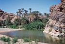
J'ai passé le Baffing wpts N 12° 45'424'' W 10°12'782''.
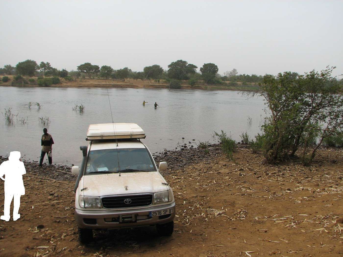
Il y avait environ 60/70 cm d'eau Par sécurité faire marcher devant le véhicule (5 à 10 m devant )2 gamins (ils sont tous volontaires) pour juger de la profondeur et surtout pour éviter les rochers et les trous.
C'est un passage soi disant fréquenté par les camions mais je n'en ai vu aucun pendant mon passage.
Pour info , je n'ai pas pu rejoindre Kita dans la journée nous avons bivouaqué 40 kms avant Kita , nous avons fait 145 kms dans la journée(8 h)
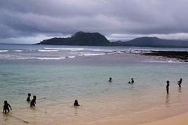
Je joins une photo prise après la traversée.
Salut,
Normalement le pont doit être terminé sur le fleuve à la frontière Sénégal/Mali. Il y a en tous les cas du goudron au Sénégal jusqu'à la frontière malienne et de gros travaux sont en cours côté malien. Même si le pont n'est pas fini, en février ça passe en 4X4. Je pense que la piste est actuellement neuve au Mali. Donc pas de problème de Saraya à Kénieba. Les formalités de sortie sont à faire à Kédougou au Sénégal et les formalités d'entrée à Kenieba au Mali (police dans la ville et douane à la sortie nord de la ville vers Kayes).
De Kenieba à Bafoulabé c'est plus compliqué. En sortant de Kénieba vers le nord (Kayes) à 20-30 kils il y a une piste sympa à droite mais un peu technique qui va sur Bafoulabé, ensuite large piste qui redescend sur Manantali et ensuite goudron et pistes larges jusque Bamako en passant par Kita où il faut payer "taxe de passage" modeste. Il existe un tracé direct de Kenieba à Manantali mais il faut connaître et c'est très lent en 4X4. Il parait qu'ils vont faire une route sur ce tracé mais cela je ne connais pas les prévisions. En fait j'ai entendu que le projet final c'est une route de Dakar à Bamako en passant par Saraya (d'ou le pont !) pour éviter le détour par Kayes et désenclaver la région de Kedougou.
Donc c'est réalisable, bon voyage.
Hello everyone. After a dozen 4x4 trips to this country before COVID, I’m planning another departure at the end of 2026 and early 2027—around three weeks starting December 27th. Main goal: Merzouga to Chegaga, sand, sand, and more sand. Mostly camping and a few campgrounds here and there.
After 40 years of traveling in Morocco, I want to explore a new area by 4x4—the Western Moroccan Sahara, which I don’t know very well.
I have plenty of tracks and itineraries, but I’d love some info to help me decide on the best route:
Part 1:
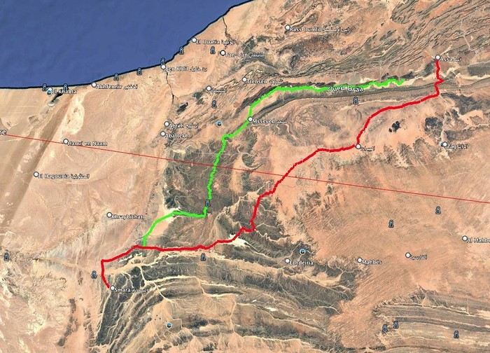
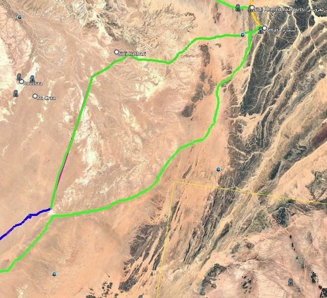
I want to do the ASSA - SMARA crossing. Basically, I have two options: the first follows the Draa River and goes through M’SIED, and the second is much further south, passing through LABOUIRAT and heading straight to SMARA.
If you have any details on road conditions, driving restrictions, etc., I’d really appreciate it.
Part 2:
SMARA - BIR ANZERANE - DAKHLA – here, I also have two routes.
The first heads west from Smara toward Sidi Kathari.
The second goes east from SMARA and gets pretty close to the border at one point (about 10 km away).
Both routes meet up about 150 km later and are nearly identical from there to BIR ANZERANE and DAKHLA.
Hi,
For next summer’s vacation, I’m thinking of returning to the Sahara after visiting Tamanrasset and the Hoggar, which was stunning—not to mention the Tuareg hospitality.
I’d like to explore the sandy desert this time since the Hoggar was 80% rocky.
So, I’m wondering which city I should prioritize if I want to go there in late July–early August for the landscapes, extreme heat, and guides offering 4x4 and camel treks. Also, if there are any recommended guides for those in the know and a decent hotel.
I’m torn between Djanet, In Salah, Adrar, Ghardaïa, and Timimoun.
I’m of Algerian origin, so no visa or other formalities to worry about.
Thanks.
Hello, I’m preparing for a Tunisia-Algeria road trip.
I need to know if we can cross the Sahara to reach Djanet and Tamanrasset by road freely,
After that, obviously off-road in the desert with a guide.
What do the authorities say?
My trip: northern and southern Tunisia, a stroll in the desert.
Crossing the Tunisia-Algeria border via the Taleb Larbi customs.
I’ve already done this route through an agency, but this time we want to do it on our own.
Then heading down to Djanet for eight to fifteen days in the desert with Mouloud, a local guide.
Direction Tamanrasset: road and tracks, the mountains of the Assekrem, the Hermitage of Père de Foucauld.
Return via the Trans-Saharan Highway.
Visit to northern Algeria, then back by boat from Oran to Spain.
Dates: late December to mid-February.
We’ve got plenty of time.
If another crew is interested, we’re already two vehicles.
Looking forward to your replies.
Hi there,
I’m planning a trip to Russia and Mongolia, starting from France.
Crossing the border at Poland/Belarus or Georgia/Russia—other borders seem either closed or complicated.
Tourist visas for 3 months with multiple entries.
Do you have any info on Russian companies that cover a 4x4 vehicle for 3 months, and what prices in rubles or euros you’ve paid?
Which bank did you use for expenses? (EuroMastercard and Visa cards no longer work.)
Regarding Russian SIM cards, a new system called "Gosuslugi" has been introduced. How long did it take you to get one, and what steps did you follow?
Hi there,
We’ll be traveling in January 2027 in a 4x4 with a rooftop tent with our three kids, from Johannesburg to Cape Town. We’ve already booked several campsites in national parks (Golden Gate / Mountain Zebra / Addo Elephant / Garden Route).
We still need to reserve the stretch between De Hoop Nature Reserve and Cape Town. Any suggestions?
We’d love to stay around Cape Town for 5 days to explore the wine route, the peninsula, and do some hikes in Table Mountain.
Any camping recommendations? Or, on the contrary, places to avoid?
Also, we have 2 nights left near Wilderness National Park / Knysna. Any recommendations?
Thanks so much for your help!
For my 60th birthday (yes, I’m jumping the gun a bit!), I’m starting to plan a self-drive trip to Tanzania (in June).
I also considered Zimbabwe but I’m worried it might be a bit chilly at night in June.
I’ve revisited an itinerary I’d thought about before, tweaking it since I’ll have more days to dedicate to this trip. Still no big northern classics for the same reasons as before (too expensive, too crowded, too many tour operators).
Here’s what I’ve got so far:
(Arrival/departure from Kilimanjaro Airport)
Night 1: Arusha
Night 2: Arusha
Night 3: Lake Manyara
Night 4: On the way to Iringa (any ideas???)
Night 5: Iringa
Nights 6–8: Ruaha NP
Nights 9–10: Mikumi NP
Night 11: Bagamoyo
Nights 12–15: Beach
Nights 16–17: Lushoto
Nights 18–19: Mkomazi NP
Night 20: Toward Marangu – eastern Kilimanjaro
Night 21: Western Kilimanjaro
End of trip
All your ideas, tweaks, info, and suggestions on this route are welcome!
I could move one beach night somewhere else if needed.
Also, if you have a car rental company to recommend or thoughts on the bandas rented in the parks, I’m all ears!
Finally, what are the roads like in Ruaha in June? The rental company I’m looking at seems to allow this park with a small 4x4. (Off-limits: Serengeti and Natron)
We’re planning a long-term trip starting in April with our 4x4, beginning in the USA.
We’re still looking for car insurance that covers Canada and the USA.
We’ve read quite a few forums, but we’re hoping for some help (from fellow travelers).
Hi,
we’re planning to visit a park again.
Could you point us toward the camps in Gonarezhou Park?
>We’re traveling completely self-sufficiently.
We love wildlife.
Thanks for any tips you can share!
JP
Hi there, we’ll be in Mozambique in early December 2026 and we’d like to travel from Vilanculos to Beira by car or bus to reach Beira airport. After that, we’re planning to visit Gorongosa National Park before flying back to France from Beira. From what we’ve heard, the road to Beira is tricky, especially at this time of year (start of the rainy season). Could anyone share their thoughts or suggest a solution? Thanks so much for your help!
Anne
Hi there,
I’m heading to Lesotho in a few days and I’m struggling to find info on the best route between Katse Dam and Sehlathebe National Park. There’s a fairly "direct" route from Thaba Tseka, but the roads seem rough, and we’re not exactly 4x4 pros. Anyone have any tips to share? Thanks!
Hi everyone,
We’re heading to Mozambique in October and are looking for either a 4x4 or 4x2 rental in Maputo, or a driver transfer option to reach:
- Ponta Do Ouro
- Tofo
- Vilankulos
The idea is to be self-sufficient for sightseeing and stops while still being able to access certain lodges or beaches that require a 4x2.
Do you have any contacts, addresses, or ideas to share?
Thanks in advance,
Hello,
We're hitting the road again in 2027 to discover new countries and cultures.
Could anyone give me some tips on driving from Ulaanbaatar to Lake Baikal and the route to take?
Thanks, and safe travels to those who are setting off!
We’re planning a 4x4 trip from Belgium to Central Asia, passing through Georgia, Russia, Uzbekistan, Kazakhstan, and Kyrgyzstan.
For these countries, our national insurance obviously doesn’t cover the vehicle, so we’ll need to get local insurance.
Will it be a problem if the vehicle is registered under person A and the national insurance is under person B? Both A and B will be in the vehicle, and both will be listed as drivers on the insurance.
When we get the local insurance, if we again list A and B as drivers, does the order matter? Could we get stuck at the border for this reason?
Hi,
For those who’ve driven on Iceland’s gravel roads in their own or a rented Duster, could you tell me what tires were fitted on the vehicle?
Were they All Terrain tires or more "standard" ones like all-season tires, for example?
Follow-up question: if they were "standard" tires, did that cause any issues on the gravel roads and rough terrain?
Thanks so much for any info you can share.
Best,
Marc
Hi there,
I'm planning a 4x4 road trip from Darwin to Broome with a rooftop tent in July 2026.
I'd like to know if I need to book overnight stops in advance or if I can just wing it and stop wherever I feel like it?
Some evenings, we'd like to stop and make use of campsite facilities (restaurant, shop, showers, toilets).
What do you recommend?
Do I need a permit?
My rough itinerary looks like this:
Darwin - Kakadu
Kakadu - Nitmiluk
Nitmiluk - Kununurra
Kununurra - Purnululu
Purnululu - El Questro
El Questro - Mt Elizabeth - Bell Gorge - Broome
I’m planning a trip to Iceland for next July-August, with a car and tent, and I’m wondering about booking campsites.
From your experience, is it necessary or even essential to book campsites in advance, or do you always manage to find a spot to pitch your tent?
We’ll also have the option to sleep in the car without pitching the tent.
Does that give us the flexibility to stay outside a campsite for a night here and there?
Hi,
I’m planning a road trip in the Middle Atlas, starting and ending in Fez and heading down to the south of Midelt, the Assoul Massif.... We’ll be traveling with two small 4x4s.
I’m looking for detailed maps of this region that include small roads and tracks.
Last year, we had a fantastic road trip in the Anti-Atlas and High Atlas using Erfahren maps, but unfortunately, they don’t cover the area we’re interested in this year.
Thanks for your suggestions!
Dominique
We’re planning a 13-day family road trip in Morocco this July, with six people in a Toyota Prado 4x4 (renting in Marrakech).
We’ll alternate between bivouacking and small hotels/riads depending on the stops.
Here’s the planned route (in this order):
Marrakech
→ Ouarzazate
→ Draa Valley
→ Zagora
→ Erg Chegaga
→ Lake Iriki
→ Foum Zguid
→ Tata
→ Tafraoute
→ Aït Mansour
→ Tiznit
→ Mirleft
→ Taroudant
→ Back to Marrakech
Our goal:
Atlas Mountains + desert + dunes + plateaus + valleys + a bit of coastline.
We’ll cover about 1,700 km in total.
We’re planning:
Bivouacking in the Chegaga/Iriki area
Flexible for the rest (booking the day before or same day)
Sand gear: traction plates, compressor, tow strap, roof rack
Questions:
Is the Zagora → Chegaga → Iriki → Foum Zguid crossing in July doable on our own (single vehicle, no guide)?
Are there any truly technical or risky sections between Chegaga and Iriki?
Does the overall itinerary seem manageable in 13 days without rushing?
Any suggestions for great bivouac spots or particularly interesting stops along this route?
The points on the route are provisional overnight stops. Some spots will include two nights in the same area.
We’re used to off-road driving, but not yet in the Moroccan desert.
Thanks in advance for your feedback and tips! 😊
Good evening
I could use some advice 🙂
Our trip to Namibia is planned for June/July 2026.
We’re struggling a bit with timing and choosing activities for the part of the trip between Sesriem and Brandberg.
Day 1: Sesriem to Mirabib
Day 2: Mirabib to Swakopmund – visit Swakopmund, overnight in Swakopmund
Day 3: Sandwich Harbour – overnight in Swakopmund
Day 4: Kayaking with the seals + the living dunes – overnight in Swakopmund
Day 5: Moon Landscape, Henties Bay + Cape Cross – overnight at White Lady Lodge in Brandberg
Does this itinerary seem realistic to you? Is Cape Cross really worth the trip? If I had to choose between Cape Cross and kayaking with the seals, which would you recommend?
Thanks in advance for your help!
Hélix
My son and I are heading to Georgia this summer to explore the High Caucasus (Svaneti, Kazbek, and Tusheti regions). For this, we’re planning to rent a 4x4.
However, the rental agencies we’ve found prohibit driving on the tracks to Omalo (Tusheti) and/or Ushguli (Svaneti).
Do you know of any agencies in Tbilisi (local and reliable) that allow rented 4x4s to drive on these tracks? If so, which ones?
Hi everyone,
I’m starting to plan an itinerary for September 2027 focused on Zimbabwe and Zambia. I’d love to visit Gonarezhou National Park—I see there are two sectors: the Mwenezi Region in the south and the area around the Runde River in the north. Should I cover both sectors or just focus on the northern region?
For the parks along the Zambezi River, is it better to visit Mana Pools on the Zimbabwe side or Lower Zambezi on the Zambia side?
Thanks in advance for any tips on the parks in these two countries.
Have a great day, everyone.
We’re spending 18 days in New Zealand from 05/04 to 05/21, arriving in QUEENSTOWN and leaving from AUCKLAND.
Any ideas for a road trip that covers the highlights of both islands but only changes hotels every 3–4 nights?
Thanks.
For our trip to Georgia in July, I’d like to rent a 4x4 starting from Tbilisi.
Do you have any rental companies to recommend?
The traditional rentals like Hertz, Avis, etc. seem way overpriced compared to local companies—what do you think? Are they properly insured?
Has anyone here tried Geo Rent Car, Auto 4 Rental, or Sur Price?
Also, I’m looking for info on the condition of the Ushguli–Lentekhi track—is it passable?
Hi everyone,
A well-prepped 4x4, a travel plan across Africa in stages since I’ve got kids to see regularly and work to earn a living.
I’m leaving in November for about a month with the goal of reaching Senegal via Mauritania. I’d love to share this trip with someone who wants to discover Mauritania and a bit of Senegal... and also experience life on board a 4x4 in the desert or bush, sometimes sleeping in the vehicle or in hostels/small hotels for comfort. I want to share this rediscovery because two’s better than one!
Just traveling, exploring, and living! !
I’m planning to explore Argentine and Chilean Patagonia for a month in December 2019.
I’m looking for a rental company (or several) that offers single-cab 4x4 pick-ups with a fitted camper cell for two people. I’m specifically after a vehicle with an indoor shower for extra comfort ;)
So, no vans—at least not from the rental companies I’ve seen so far.
While browsing the forum, I came across the Chilean rental company Holiday Rent. But do you have any recommendations for Argentine rentals?
Because, if I can’t return the vehicle in the same city as pickup, I’d prefer—and it’d likely be cheaper—to at least return it in the same country.
I’m traveling through Argentina and Chile (as well as Paraguay and Uruguay) with a 2019 Toyota Hilux Euro 6. Could anyone tell me if the local diesel is suitable for its engine, or if I need to take any special precautions (like adding an additive, for example) for these countries?
I’d also like to know if driving at high altitudes is possible, and up to what elevation—or if I should worry about the vehicle going into limp mode?
If that happens, what should I do?

 Au Sénégal, le Japon a apporté par le passé un appui important à ce secteur, qui a porté sur le développement des infrastructures, y compris les infrastructures de données spatiales et les technologies de l’information et de la communication.
C’est ainsi que les projets suivants ont été mis en œuvre:* Construction de la Nouvelle Maison de la RTS en 1987 ;* Fourniture de programmes de TV à la RTS en 1989 ;* Renforcement des capacités télévisuelles de la RTS en 2005 ;* Etude sur le système de gestion de l’information sur les infrastructures socio-économiques de la zone urbaine de Dakar en 2000 ;* Mise en place d’un système de gestion de l’information sur les infrastructures socio-économiques de la zone urbaine de Dakar en 2002 et Affectation d’un expert japonais pour une durée de 2 ans ; * Stages de Renforcement des capacités cartographiques et géographiques des pays africains de 2004 à 2006.
Au Sénégal, le Japon a apporté par le passé un appui important à ce secteur, qui a porté sur le développement des infrastructures, y compris les infrastructures de données spatiales et les technologies de l’information et de la communication.
C’est ainsi que les projets suivants ont été mis en œuvre:* Construction de la Nouvelle Maison de la RTS en 1987 ;* Fourniture de programmes de TV à la RTS en 1989 ;* Renforcement des capacités télévisuelles de la RTS en 2005 ;* Etude sur le système de gestion de l’information sur les infrastructures socio-économiques de la zone urbaine de Dakar en 2000 ;* Mise en place d’un système de gestion de l’information sur les infrastructures socio-économiques de la zone urbaine de Dakar en 2002 et Affectation d’un expert japonais pour une durée de 2 ans ; * Stages de Renforcement des capacités cartographiques et géographiques des pays africains de 2004 à 2006. Dans son Plan d’Actions pour les cinq prochaines années, initié lors de la 4ème Conférence Internationale de Tokyo pour le Développement de l’Afrique (TICAD IV), tenue en septembre 2008 au Japon, le Gouvernement du Japon a placé les Infrastructures de transport régionales, y compris les Ports, dans les hautes priorités.
En plus, dans une dynamique de soutien au NEPAD, le Gouvernement du Japon a exprimé son engagement à contribuer à la réduction de la pauvreté par le biais de la croissance économique en apportant une aide prioritaire au développement des infrastructures qui contribue au renforcement de l’intégration économique africaine.
Dans son Plan d’Actions pour les cinq prochaines années, initié lors de la 4ème Conférence Internationale de Tokyo pour le Développement de l’Afrique (TICAD IV), tenue en septembre 2008 au Japon, le Gouvernement du Japon a placé les Infrastructures de transport régionales, y compris les Ports, dans les hautes priorités.
En plus, dans une dynamique de soutien au NEPAD, le Gouvernement du Japon a exprimé son engagement à contribuer à la réduction de la pauvreté par le biais de la croissance économique en apportant une aide prioritaire au développement des infrastructures qui contribue au renforcement de l’intégration économique africaine. Pour cadrer avec ces orientations stratégiques, les interventions du Japon dans ce secteur se déclinent présentement à travers la réalisation du corridor Bamako-Dakar par le sud qui intègre le "Programme d’Actions Communautaires des Infrastructures et Transport Routiers" (PACITR) de l’UEMOA.
Ce corridor d’intérêt communautaire, est un des axes majeurs nécessaires à la préservation et à l’amélioration des échanges terrestres entre les populations frontalières. Ce qui fait que l’impact socio-économique de cette liaison routière profite aux deux Etats (Mali et Sénégal), mais aussi aux pays voisins, à travers le désenclavement des zones desservies, l’accroissement de la mobilité et la liaison avec les voisins mais surtout le développement des activités agricoles et de commerce dans la région.
Pour cadrer avec ces orientations stratégiques, les interventions du Japon dans ce secteur se déclinent présentement à travers la réalisation du corridor Bamako-Dakar par le sud qui intègre le "Programme d’Actions Communautaires des Infrastructures et Transport Routiers" (PACITR) de l’UEMOA.
Ce corridor d’intérêt communautaire, est un des axes majeurs nécessaires à la préservation et à l’amélioration des échanges terrestres entre les populations frontalières. Ce qui fait que l’impact socio-économique de cette liaison routière profite aux deux Etats (Mali et Sénégal), mais aussi aux pays voisins, à travers le désenclavement des zones desservies, l’accroissement de la mobilité et la liaison avec les voisins mais surtout le développement des activités agricoles et de commerce dans la région.

 II. Les Actions en cours
 le Programme de d’aménagement routier et de facilitation du transport sur le corridor Bamako-Dakar par le sud
Le Japon intervient en co-financement sous forme de prêt concessionnel dans ce programme avec la Banque Africaine de Développement (BAD) et la Banque Ouest Africaine de Développement (BOAD) sur les tronçons routiers entre Kédougou et Falémé (réhabilitation du tronçon Kédougou-Saraya : 61 Km ; construction du tronçon Kharakhéné-Falémé : 21,3 Km).
Le programme a pour objectif de contribuer au renforcement de l’intégration économique et de la coopération sous-régionale, et au désenclavement des pays.
le Programme de d’aménagement routier et de facilitation du transport sur le corridor Bamako-Dakar par le sud
Le Japon intervient en co-financement sous forme de prêt concessionnel dans ce programme avec la Banque Africaine de Développement (BAD) et la Banque Ouest Africaine de Développement (BOAD) sur les tronçons routiers entre Kédougou et Falémé (réhabilitation du tronçon Kédougou-Saraya : 61 Km ; construction du tronçon Kharakhéné-Falémé : 21,3 Km).
Le programme a pour objectif de contribuer au renforcement de l’intégration économique et de la coopération sous-régionale, et au désenclavement des pays. L’objectif spécifique étant de : (i) créer une liaison routière permanente par le sud, de bons niveaux de services entre le Mali et le Sénégal et lever les entraves à la circulation en vue de réduire les coûts généralisés de transports et promouvoir les échanges économiques entre les deux pays ; (ii) améliorer la durabilité des investissements par le contrôle des charges à l’essieu ; (iii) améliorer les conditions de vie des populations de la zone du projet.
Le programme comprend des travaux routiers (en béton bitumineux 05 cm) et d’aménagement d’infrastructures socio-économiques (cases de santé, forages, pistes, rurales…) pour répondre à des besoins immédiats des populations riveraines, ainsi que des mesures de facilitation du transport et du transit sur le corridor.
Ce programme est en conformité avec les objectifs du NEPAD dont il fait partie du plan d’actions à court terme.
Cette partie des travaux de ce programme (côté Sénégal) qui ont démarré en février 2008, est pratiquement achevée.
L’objectif spécifique étant de : (i) créer une liaison routière permanente par le sud, de bons niveaux de services entre le Mali et le Sénégal et lever les entraves à la circulation en vue de réduire les coûts généralisés de transports et promouvoir les échanges économiques entre les deux pays ; (ii) améliorer la durabilité des investissements par le contrôle des charges à l’essieu ; (iii) améliorer les conditions de vie des populations de la zone du projet.
Le programme comprend des travaux routiers (en béton bitumineux 05 cm) et d’aménagement d’infrastructures socio-économiques (cases de santé, forages, pistes, rurales…) pour répondre à des besoins immédiats des populations riveraines, ainsi que des mesures de facilitation du transport et du transit sur le corridor.
Ce programme est en conformité avec les objectifs du NEPAD dont il fait partie du plan d’actions à court terme.
Cette partie des travaux de ce programme (côté Sénégal) qui ont démarré en février 2008, est pratiquement achevée. le Projet de construction de Ponts sur le corridor Bamako-Dakar par le sud en république du Mali et en république du Sénégal
Cet appui entre dans le cadre de la Coopération Financière Non Remboursable du Japon. Il s’agit de la construction de 3 ponts sur la Falémé (frontière Sénégal-Mali), le Bafing et le Balé (tous les deux en territoire malien).
* Pont sur la Falémé: Pont mixte constitué de neuf (9) travées à poutres en béton précontraint en forme de I de 30,5 m chacune. Culées : 2 ; Piliers : 8 ; Longueur : 274,3 m ; Largeur : 10,5 m ; Voie d’accès : 29,7 m ; Hauteur libre de passage : 4,50 m.
Démarrage des travaux : octobre 2009; Achèvement prévu en août 2011.
* Pont sur le Bafing: Pont mixte constitué de sept (7) travées à poutres en béton précontraint en forme de I de 34,0 m chacune. Culées : 2 ; Piliers : 8 ; Longueur : 237,8 m ; Largeur : 10,5 m ; Voie d’accès : 287,2 m.
Démarrage des travaux : janvier 2010; Achèvement prévu en octobre 2011.
* Pont sur le Balé: Pont mixte constitué de trois (3) travées à poutres en béton précontraint en forme de I de 23,5 m chacune et une travée à poutre métallique en acier simple de 40 m de portée. Les culées : 2 ; Piliers : 3 ; Longueur : 110,15 m ; Largeur : 10 m ; Voie d’accès : 29,85 m.
Démarrage des travaux : septembre 2008; Travaux achevés en octobre 2009.
La construction de ces ponts permettra d’assurer une circulation fluide pendant toute l’année dans la région ce corridor, de dynamiser l’économie des deux pays, de réduire la pauvreté et d’améliorer l’accès aux services sociaux pour les résidents le long de la route. En outre, le projet contribuera à la revitalisation de l’économie et à la promotion de l’intégration économique en Afrique de l’ouest.
le Projet de construction de Ponts sur le corridor Bamako-Dakar par le sud en république du Mali et en république du Sénégal
Cet appui entre dans le cadre de la Coopération Financière Non Remboursable du Japon. Il s’agit de la construction de 3 ponts sur la Falémé (frontière Sénégal-Mali), le Bafing et le Balé (tous les deux en territoire malien).
* Pont sur la Falémé: Pont mixte constitué de neuf (9) travées à poutres en béton précontraint en forme de I de 30,5 m chacune. Culées : 2 ; Piliers : 8 ; Longueur : 274,3 m ; Largeur : 10,5 m ; Voie d’accès : 29,7 m ; Hauteur libre de passage : 4,50 m.
Démarrage des travaux : octobre 2009; Achèvement prévu en août 2011.
* Pont sur le Bafing: Pont mixte constitué de sept (7) travées à poutres en béton précontraint en forme de I de 34,0 m chacune. Culées : 2 ; Piliers : 8 ; Longueur : 237,8 m ; Largeur : 10,5 m ; Voie d’accès : 287,2 m.
Démarrage des travaux : janvier 2010; Achèvement prévu en octobre 2011.
* Pont sur le Balé: Pont mixte constitué de trois (3) travées à poutres en béton précontraint en forme de I de 23,5 m chacune et une travée à poutre métallique en acier simple de 40 m de portée. Les culées : 2 ; Piliers : 3 ; Longueur : 110,15 m ; Largeur : 10 m ; Voie d’accès : 29,85 m.
Démarrage des travaux : septembre 2008; Travaux achevés en octobre 2009.
La construction de ces ponts permettra d’assurer une circulation fluide pendant toute l’année dans la région ce corridor, de dynamiser l’économie des deux pays, de réduire la pauvreté et d’améliorer l’accès aux services sociaux pour les résidents le long de la route. En outre, le projet contribuera à la revitalisation de l’économie et à la promotion de l’intégration économique en Afrique de l’ouest.


 III. Contacts Bureau de la JICA au Sénégal
Mme Ayumi TAKAGI
III. Contacts Bureau de la JICA au Sénégal
Mme Ayumi TAKAGI  AsiaOceaniaLatin AmericaAfricaMiddle EastEurope