Nous souhaitons partir au Vietnam en Juillet 2017 avec nos 3 enfants (10, 12, 15)
Je suis au début de mes recherches.
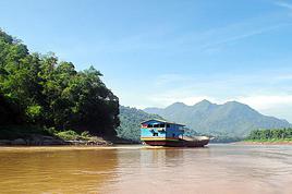
Nous arriverions sur Hanoi et souhaiterions faire un trek. Je commence à me renseigner et je vois que la région de Bac Ha me parait pas mal. Par contre pour y aller j'ai vu qu'il existait des bus de nuit (10h).
Comment est la route ?
J'ai 2 enfants malades en bus et je me dit que c'est peut être un peu loin...
Quelle est la région la plus proche d'Hanoi qui permettrait de faire des treks sympas ?
Bonjour,
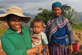
Près de Hanoi, je vous propose d’aller à Mai Chau, une vallée paisible. Depuis Hanoi, il faut consacrer 4 heures de route pour s’y rendre. Je vous conseille donc faire un voyage de 2 jours pour bien profiter sa beauté. Avec une région de pains de sucre et de rizières en terrasse, Mai Chau est peuplée par les Thaïs blanc et les Muong qui vous accueillent dans leurs maisons sur pilotis avec de grands sourires et avec de l’alcool de riz. Elle est vraiment une région très propice au trekking pour des excursions d’une à plusieurs journée.
Près d’Ha Noi il y a plusieurs lieux à faire du trek. Vous pouvez aller à Tam Dao (40km depuis Ha Noi), ou la zone de camping et de trek d’Ham Lon. Le climat à Tam Dao est très agréable tandis que Ham Lon a les superbes endroits à la fois un grand terrain et la montagne.
Ces endroits sont non seulement près d’Ha Noi, mais aussi le tarif pour y aller est très raisonnable. Si vous choisissez Tam Dao, Ham Lon ou un autre lieu, vous ne mettez qu’environ 50€ pour un meilleur trek et camping là-bas.
Bonne préparation.
Bonjour,
pour rejoindre la région de Bac Ha, il y a aussi les trains couchettes. c'est une super expérience pour les enfants et ensuite vous rejoignez Bac Ha par la route soit avec chauffeur (on en trouve à la gare) soit en transport.
Super pays fait avec notre fils de 4 ans.
Myriam
Myriam 😇
"Rester, c'est exister. Voyager, c'est vivre."
Gustave Nadaud
Hanoi-Bac Ha, c'est 8 heures de bus de nuit. Préférable prendre le train de nuit Hanoi-Lao Cai + bus LC-BH (2 heures). Excellent trekking + les marchés
Pas de trekking à Mai Chau meme ; il faut aller au parc du Pu Luong à Ban Hieu (superbe) ou au massif du Kia ; aucun transport public entre MC et ces 2 destinations. Par contre, en voiture, il y a un tour extraordainaire à faire Hanoi-Ban Hieu trekking 1 ou 2 jours)-Mai Chau-Hanoi, ou meme Ban Hieu-Mai Chau-Son La-Mu Can Chai (une des + belle routes que je connaisse)-La Pan Tan-Nghia Lo (la célèbre "route des Photographes")-Hanoi
Je ne connais pas le Tam Dao, mais je doute qu'on y trouve la meme variété de minorites et je pense que les montagnes du Nord sont tout de meme préférables. Ancien centre de villégiature des Français, c'est surtout une destination de week-ends et fetes pour les Viets de Hanoi. Je vais y aller un jour en moto, avec petit rapport à la clé
Méfiez-vous de la vie, car les ratés ne vous rateront pas!
D'Hanoi le plus près c'est Mai Chau.
C'est vrai que Bac Ha est très sympa mais moins accessible et beaucoup plus loin (bus ou train et bus).
Si tu veux voir sur notre blog des photos, nous avons fait les 2.
Trek Mai Chau clique ici
Trek Bac Ha 1 clique ici
Trek Bac Ha 2 clique ici.
Au niveau des treks j'ai préféré la région de Mai Chau. Par contre à Bac Ha ou proche, il y a des marchés authentiques très sympa.
Michèle
Michèle
http://mjm-nosvoyages.blogspot.fr/ Ethopie 2020-Birmanie 2017-New York 2015-Sicile 2015-Ouest américain 2015/16/17/18/19 - Madrid/Barcelone - Cinq Terre 2017-Prague 2018-Venise 2019
http://surlarouteasiatique.blogspot.fr/ 2014 : périple de 9 mois Cambodge, Laos, Vietnam et ouest Américain
Si vous souhaitez faire la randonnée près de Hanoi, vous pourrez:
- Soit faire le trek à Pu Luong. Randonnée facile. C'est une région habitée par l'ethnie Thai.
- Soit faire le trek à Ngoc Son Ngo Luong. Randonnée facile. C'est une région habitée par l'ethnie Muong
- Soit vous faites la randonnée de 03 - 04 jours à Ngoc Son Ngo Luong, puis à Pu Luong.
Depuis Ngoc Son à Pu Luong, il vous faut traverser les 18km en traversant la forêt, le ruisseau pour rejoindre Pu Luong. Si vous souhaitez raccourcir la distance, vous pouvez payer pour un parcours à moto.
@ Si vous souhaitez un parcours avec de petits budgets: Vous pouvez prendre le bus local jusqu'à Bac Ha.
- Pour la région de Bac Ha: Le bus ne nuit n'est pas terrible. Je suis aussi malade avec les bus. Mais c'est ok. Sauf le trajet depuis Lao Cai à Bac Ha qui est avec la route de montagne, si non, le trajet depuis Hanoi jusqu'à Lao Cai est ok, le bus ne prend pas la route de montagne pour ce trajet là. Le bémol du transfert en bus de nuit pour Bac Ha: Si vous être grands, la longeur de couchette n'est pas de votre taille. Il vous faut choisir des couchettes en dernier rang, pour pourvoir s'étendre vos pieds.
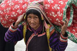
J'aime bien la région de Bac Ha qui a des coins de charmes et qui est vraiment hors des sentiers battus.
Le point faible de ce parcours de trek: la condition des maison d'acceuil est vraiement rustiques. Sauf quelques maisons d'acceuils dans les envrions de Bac Ha: au village de Na Lo, Na Kim, et Ta Van Chu, une maison à Ta Cu Ti, une maison à Lau Thi Ngai: Si non, ailleurs, c'est vraiement rustique.
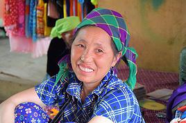
@ Si vous souhaitez avoir des treks dans une régions avec: une mosaique des ethnies minoritaires: H'mong bariolé, Dzao Rouge, Dzao Tapan, Tay, Nung... Et surtout avec le paysage bucolique: Il vous faut aller dans la région de Hoang Su Phi. La régions vaut la peine pour les 4 - 5 jours.
Cordialement,
Je ne sais pas quel est votre budget pour le voyage 1 petit mois au Vietnam. Dans les grandes villes touristiques, Vous n'avez pas besoin de location de moyen de transport privee, pas de guide, plutot quartier libre. Mais a l'exterieure des villes, il faut penser au comfort pour vous et vos enfants au niveau du transport. Si vous devez chercher ou est la gare routiere pour prendre le bus de ligne, train...les services. Ce n'est pas tres facile et rigolo, surtout les vietnammiens , ils ne parlent pas tous les langues etrangeres: Anglais, francais... Alors c'est important d'avoir un bon guide ou quelqu'un du pays qui parle francais. Sinon, vous allez rater des contacts avec les gens.
Petit retour sur notre grosse journée à Hanoï avec nos tites puces! Ca peut vous donner des idées si vous envisagez un trip au Vietnam avec vos loulous! C'est…
Mon mari, nos deux enfants et moi partons au Vietnam du 05 avril au 25 avril. Nous serons à Danang le 18 avril et souhaitons après du 18 au 24 soit 6 nuits et…
Nous serons en famille deux enfants 5 et 7 ans, à Hanoi du 01/01 au 09/01. J'aimerai avoir votre avis sur cette période. Et que ce que je pourrai visité? -…
Nous projetons de partir en famille (avec 2 enfants 6 et 10 ans) 3 semaines au Vietnam (depuis Barcelona où nous vivons) au mois d'aout (pas forcément la…
Nous sommes une familles avec 3 enfants (12, 13 et 15 ans) Plutôt backpacker dans l'âme, nous ne cherchons pas le confort à tout prix. Nous sommes à la…
Bonjour,
Nous souhaitons faire le trek de 4 jours reliant Mestia à Ushguli sans agence. Il est précisé dans les descriptifs qu'il existe des hébergement à chaque étape, mais on ne trouve pas d'info sur ces hébergements. Quelqu'un a-t-il des infos et un avis sur ce parcours?
We're planning to trek in Peru and Bolivia and would love to find some local agencies.
If you know any, could you share details on prices and, of course, the names of the agencies?
Which trek would you recommend?
Elocine
Je pars en autonomie totale sur un trek au Maroc (10jrs) Imilchil - Aghbalou.
Trouve t-on des cartouches gaz à vis (Coleman, Primus) à Marrakech (adresse) ou villages entre Imilchil - Aghbalou ?
Si non , trouve-t-on des cartouches Butagaz pour camping-gaz (petit volume 230 gr ...)
Merci d' avance pour vos réponses
Hello, I’d like to embark on a little trip in my home country, Switzerland. I’ll start walking from La Cure, heading toward Le Noirmont first, then I’ll improvise my route—but it’ll probably follow the French border... at least as far as Lac de Joux.
I’ll decide day by day how much farther to go after that. My goal is to stay in nature as much as possible, wander around for as long as I can, and restock food in villages or towns along the way.
I’m thinking of mostly camping, but we’ll see if I end up in a hotel or another campsite depending on my route.
I’d love to reach La Chaux-de-Fonds on foot... maybe even Delémont.
The whole thing should take about a week, give or take.
I’ll be bringing my dog, and I’m preparing for this as soon as I’m ready.
Any tips to make sure everything goes smoothly for us? Things I should know—or avoid? What about shepherds with their flocks of sheep? And isn’t hunting season open right now?
I’m not sure if what I’m planning is even doable, which is why I’m asking around.
This’ll be my first time doing something like this—wandering in nature *and* with a dog. I’m really excited for this adventure... and I need it. Thanks!
We’re really keen on ecosystems and want to hike in "natural" ancient forests—not planted woods or areas heavily degraded by human activity. Travel guides (like Lonely Planet) don’t provide much info on this. Could you point us to the most interesting spots?
Thanks in advance for your tips.
We wish you happy holidays and a fantastic 2026, full of discoveries!
Claire and Albert
Hi, this might not be the right section, but I’d like to know if it’s possible to start mountaineering with another person without necessarily hiring a guide. We’ve done quite a bit of hiking but not mountaineering—we’ll just do a half-day glacier course. After that, we were thinking of starting with La Grande Motte and the Pointe de la Traversière, which were recommended to us. Honestly, for things like roping up and knots, I’ll learn at home with lots of videos and a book.
Hi,
I don’t know Switzerland at all and was wondering if Vallée des Joux and especially Dent de Vaulion are packed early in the morning or late in the afternoon in July and September?
If so, do you have any quieter spots to recommend in the area, or in Luxembourg (yes, I know it’s not the same country 😉)?
Thanks a lot!
Jaimerais savoir si quelqu'un aurait fait des treks sur le Ruwenzori et combien ça coute en moyenne, les infrastructures, les paysages la sécurité sur les lieux, merci beaucoup. J'attends avec impatience vos réponses.
We’re leaving in 9 days for a two-week trip to Madeira, mainly to hike.
From my research, I’ve found that since last year, access to most trails—and systematically for the most popular ones—is now paid. You have to pay an access fee of 4.50 € per person per classified hike in 2026, and even 10.50 € for the most iconic hike: Pico Arieiro to Pico Ruivo. When paying, you also have to choose a day and a 30-minute time slot for your start time. Of course, this reservation is neither changeable nor refundable, even if the weather that day is terrible.
Personally, given the massive influx of tourists to the island in recent years, I don’t mind paying a fee to help maintain the trails. Similarly, setting a limit on the number of people who can hike them per day is certainly preferable to preserve this priceless heritage.
However, what’s much less fair is that in reality, most of the available spots are reserved: 1/ for Madeira residents (which is normal); 2/ for "economic operators" (meaning local tour operators). For example, if you’re a non-resident (independent tourist), no booking is possible for the Pico Arieiro hike for an early morning start before September! So, unfortunately, we’ll have to skip this hike.
It’s the same issue for Ponta de São Lourenço, the 25 Fontes, Pico Ruivo... in short, all the most popular hikes. Oh well, we’ll skip those too!
So my question is: which hikes do you recommend where we won’t face the huge crowds that the others get? And where we can book the day before for the next day, taking the weather into account?
Finally, a quick accommodation question: we’ve booked the first week in Funchal, but I haven’t decided yet for the second week. Do you have any advice on where to stay in the south or north, preferably avoiding overly concrete-heavy and touristy spots?
I’m reposting about the logistics for Samaria Gorge.
I’d love to get recent info, especially about whether it’s possible to park my car in Omalos, do the hike, and then catch a bus back to my vehicle.
In theory, it’s doable, but when you check the KTEL website, there aren’t any feasible schedules listed. If anyone has recently organized this with reliable, verified details, I’d really appreciate it. Thanks in advance!
Hi there,
We’re flying from Montreal to Lyon this August to go hiking in the French Alps. We’ve rented a car and will be staying at campgrounds. We’re planning to do day hikes and want to stay a few days in one spot, do a few hikes, then move on to our next camping spot. Could you share your favorite spots or any recommendations for places to spend a few days with great hikes?
A few details:
We arrive in early August and leave in early September.
We’re looking for day hikes (or shorter), moderate difficulty, with a cumulative elevation gain of no more than 1000m, and of course, beautiful scenery!
We’d prefer not to drive too much—maybe it’s best not to head too far south and deal with unnecessary heat?
Along the same lines, if you know of any great campgrounds where we can start our hike directly without needing the car, we’d love to hear your suggestions!
Bonjour
Souhaitant faire de la randonnée sur cette île, je voudrais d'abord savoir quelle serait la période la plus favorable sachant que j'avais passé quelques jours en novembre 2018 pas pour cette activité mais plus pour une simple découverte de l'île et le temps n'était pas top notamment en montagne. Donc peut on choisir une organisation en étoile sachant que je louerai un véhicule avec éventuellement 2 points d'hébergement.
Je n'envisage pas d'intégrer une structure mais de partir à 2 et de s'organiser sauf si vous me conseillez une agence locale ou un guide local. Enfin même si je compte me procurer les différents supports, carte et topo guide plus gps je vous remercie de bien vouloir me communiquer les randos à faire en priorité
Merci beaucoup pour vos informations
I’m planning to do the Mercantour crossing following the Randoxygène route in mid-July.
I’m used to hiking in the mountains, but I sometimes get vertigo, for example on ridges with drops on both sides. I wanted to check if there are any T4 or T3-T4 sections and find out if there are any very exposed passages—and if so, where—so I can plan an alternative route.
Can anyone give me some info on this?
Thanks!
I’m planning a trip around Cap Corse and the AGRIATES in 2026, from May 8th to 15th (there are still 2 spots left, by the way! Just DM me if you're interested).
I’d love to know which hikes are worth prioritizing in the AGRIATES. We’ll be staying in SALECCIA for two days as our base—what should we focus on from there?
A round trip to IGNHU beach? Any other suggestions?
For Ostricano, I think it’s too far for a round trip...
Thanks for your tips!
Have a great day,
Anie, Toulouse
I’d like to get some info about the GR10 Pyrenees traverse. I need help planning the daily stages and accommodations—my wife isn’t an experienced hiker but walks a lot, so I’d like to schedule shorter walking days and thus a longer overall trip in terms of number of days.
Could anyone give me some help and advice?
Best regards,
New to this forum, I’m planning a pretty big project for 2028.
I’m heading to Nepal to do a trek from Kathmandu all the way to Everest Base Camp (a cool 5,300 m 😄).
This trek is a bit special because even though I’ll be part of a group, I’m going solo (so far, no problem—I’m used to it). But it’s my first real trek, and it’s also a humanitarian one: once I reach base camp, I’ll stay an extra week to help clean up the waste left by tens of thousands of climbers! Since I’m originally from South America, from two countries that share the Andes, I have a deep respect for mountains—they fascinate me. So Everest… it’s kind of the trip of a lifetime!
So, a little question for those who’ve done treks to Everest before… any tips for good mental preparation (I’m already working on the physical side)?
Hi there, I’m planning the Annapurna Circuit for March 2027 and I’m looking for a local agency with a local guide—preferably French-speaking—to arrange this trek for us. Any suggestions? Thanks
Hello!
We’re spending a few days in Toraja country at the end of May. We’d love to do a day trek—taking our time—on a route that’s stunning in terms of scenery, but not a level 5 in difficulty!
Any suggestions you can share, please?
Thanks in advance
I’d like to do the Mare a Mare Sud in May over 4 days. I’ve found quite a few places to stay along the route, but I’m stuck on the start and finish.
I’ll be arriving by plane on Sunday evening and would like to start pretty early on Monday morning. Ideally, accommodation right at the trailhead (Alzu di Gallina) would be amazing, but I can’t find anything. Any tips?
Also, for the transfer from Figari Airport to Porto Vecchio or Alzu di Gallina?
At the end, I’d like to pick up a rental car—any advice on that too?
I’m traveling solo by plane to Catania in May and plan to hike the northern side of Etna, starting from Linguaglossa where I’ll arrive by bus. After that, I’d love some info on how to get up to Piano Provenzana (shuttles or hitchhiking), since it seems there’s no public transport except in the summer. Can you sleep there in a free or cheap refuge, or camp? And how far up can you go without having to hire a guide? Thanks in advance. Bernard.
Bonjour a tous,
je pars en voyage au Maroc en aout et nous allons commencer par nous arrêter a Chefchaouen(nous sommes en voiture).
Ma question: quelqu'un peut il m'indiquer un itinéraire de rando en boucle d'entre 5 et 7 jours aux départ de Chefchaouen dans le parc de Talassemtane passant si possible par le pont de dieux?Ou un guide papier qui en reunis quelques uns?
Nous privilégions le camping sauvage et les gites.
Merci d'avance
Hi there, for those who’ve been recently—is it possible to find other solo travelers in March on the island to share transport or room costs? It doesn’t seem easy to travel on a budget.
If you have any recommendations for simple lodgings or places with dorms, I’d love to hear them.
For those who’ve done multi-day treks while moving around: do you need to bring your own sleeping bag? I’d love to hear about itineraries you’ve done without a guide, just with a map and GPS.
Thanks, and have a great day!
Hi everyone!
We’re planning a 15-day road trip to Scotland this summer, specifically to explore and hike on Lewis and Harris—places we’ve never been before. We’ve visited other islands on previous road trips in Scotland (we usually go in April for a week). This would be our first time in Scotland in the summer and for 15 days. We’re looking at late August to early September.
I’m currently drafting the itinerary. We’d be crossing from Ullapool and were thinking of spending 3 nights on Harris and 4 nights on Lewis.
Does that sound balanced to you? Is it better to keep the same accommodation on Harris and the same on Lewis to explore the area? I’d love to hear about any past experiences you’ve had on these islands.
Thanks!
Hi there, I’m trying to leave for 15 days very soon to São Vicente. I’m either looking to join an agency or figure things out on my own to go hiking on one of these islands or both. From what I’ve seen, it’s not easy to organize with local transport, so it gets expensive. Can I use the services of a small local agency? I’m looking for the simplest way to hike for several days. Also, how do you get from São Vicente to São Nicolau? Thanks in advance and have a great day!
Aichatou
I’ve been wanting to do this for several years, and this year’s the one. Next September, I’ll be trekking in Tusheti (Georgia), from Omalo to Shatili.
Of course, I won’t be renting a vehicle that’d just sit unused. No problem getting to Pshaveli, but from there to Omalo, it’s a dirt road (still the case?)
There must be some form of public transport since there are so many guesthouses, and not all travelers come in a 4x4.
If any of you have been to Omalo, could you confirm that these shared transports exist and how often they run?
we’re planning a trip to Yellowstone and hoping to do a three-day backcountry hike if we get a permit.
if any of you have done this before, could you let me know if it’s possible to find water along the way? And if we can transport it, are we allowed to use a stove?
Hello,
I’ll be in Nepal from March 6th to 29th (we’re flying into Kathmandu via Varanasi and leaving via Delhi).
I’m a bit confused about the regulations requiring a guide.
My wife and I (we’re 63 and 64) aren’t experienced trekkers—we’re more used to walking on terrain with very moderate elevation changes. I’m looking for fairly easy hikes, possibly day trips.
Here are my questions:
- Does the Poon Hill trek from Pokhara require a guide, or is it better to go through a local agency? (I’ve seen a lot of them offering 4-day packages)
- I’d like to do a few multi-day hikes around Jomsom (Kagbeni, Mukitinath, Lupra, Marpha)... Do you need a guide for those, and can you find accommodations easily without booking in advance?
Last question—I’m really hesitant to lug around a sleeping bag or down jacket during our 6 weeks in India. Can you easily find these kinds of items at reasonable prices in Pokhara?
Thanks in advance for any tips you can share!
Yann