Je suis à la recherche d'information pour un trek de 7 jours sur l'île de La Gomera à la mi-septembre 2017
Nous serons 2 et nous souhaiterions faire le tour de l'île à pieds en itinérant.
Nous n'aurons pas de voiture.
Est-il facile de tout faire à pieds ? Faut-il réserver ses nuits à l'avance ou a cette période on peut se permettre de voir sur place ? (Ca a l'air assez compliqué de réserver en ligne)
Quelqu'un aurait un itinéraire pédestre de 7 jours sous la main ?
Les informations que je trouve sont très peu nombreuses et pour les randonnées itinérantes je trouve quasiment que des voyages proposés par des agences (donc pour les logements c'est difficile de se faire une idée et il y a souvent des transfert organisés par l'agence, donc seul est-ce possible de faire des transfert simplement)
Donc nous arriverons en matinée à San Sebastian et de là on souhaite partir à pieds, je suis preneur de toutes vos informations, merci.
Voici le parcours que j'ai composé à partir du GR132
- Etape 1 : Rejoindre Hermingua en bus depuis San Sebastian. Le jour suivant trek dans le Parc de Guarajonay puis retour à Hermingua pour la nuit
- Etape 2: Hermigua - Agulo - Vallehermoso:15,6 km et 1050 m de dénivelé.
- Etape 3: Vallehermoso - Alojera - Valle Gran Rey: 20,1 km et 1400 m de dénivelé.
- Etape 4: Valle Gran Rey - La Dama: 16,4 km et 1100 m de dénivelé.
- Etape 5: La Dama - Alajerò - Playa de Santiago: 16,8 km et 1300 m de dénivelé.
- Etape 6: Playa de Santiago - San Sebastiàn: 20,9 km et 1200 m de dénivelé.
Il me reste à trouver les logements pour les nuits de chaque étape.
Pour la mi-septembre est-il préférable de réserver à l'avance ou est-il possible d'arriver directement le jour même ?
Est-il possible de faire la traversée los Cristianos ou Puerto Colon jusque San sebastian sur un petit bateau pour éviter de prendre les gros Fred Olsen ou Armas ?
Je n'ai pas fait de randonnées itinérante mais seulement à la journée sur La Gomera, je te laisse quand même mon carnet de voyage aux Canaries, ça peut t'aider 😉
Merci, sympa le carnet de voyage,
effectivement en itinérant c'est différent. Pas trop d'infos ici, ça sera donc "au petit bonheur la chance" on ira sans rien réserver, après tout c'est pas non plus le fin fond du désert on ne devrait pas mourir perdus ;)
Je serais à La Gomera fin octobre en rando itinérante.
Les bus : http://www.guaguagomera.com/lineas-y-horarios/
Notre parcours :
1- Roque Agando – Chipude & hébergement hotel Sonia
2- Chipude – Hermigua & hébergement sur booking Apartementos Playa
3- Hermigua - Agulo - Vallerhermoso & hébergement sur booking
4- Vallerhermoso – Valle Gran Rey Vallerhermoso – Valle Gran Rey
Bonne rando
Jacques
Bonjour,
Effectivement je n'ai pas fait de retour de mon trek vous faites bien de me le demander.
Nous souhaitions faire le tour de l'île en rando itinérante mais comme vous j'imagine j'ai eu bcp de mal à trouver des retours d'expérience sur une semaine. On est donc parti comme ça avec les quelques infos que l'on avait réussi à trouver.
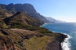
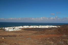
Nous sommes donc arrivés à San Sebastian avec le ferry depuis Los Cristianos. De là nous sommes montés dans les hauteurs depuis la droite de San Sebastian vers le Parc Naturel de Majona pour rejoindre Hermigua. Sauf qu'à la fin de la première journée nous ne trouvions plus la signalisation, impossible de poursuivre nous étions perdus tout en haut à l'entrée du parc naturel de Majona. Nous étions face à la mer et le vent soufflait bien (même s'il faisait très chaud)
Pas d'autre solution que de planter la tente au milieu de rien et de voir le lendemain matin. Expérience un peu stressante sur le coup mais magnifique en réalité. Nous avions une vue imprenable sur le Teidei juste devant nous. Toute la nuit la tente claquait avec le vent mais finalement aucun soucis. Après avoir tourné presque 2h nous avons fini par retrouver notre chemin vers Hermigua par contre après un bon moment de marche nous sommes tombés sur un panneau avec les kms restant, il restait 18kms jusque Hermigua. Nous n'avions plus d'eau et nous pensions être plus prêt après avoir marché une journée. Impossible donc de continuer. En contre bas il y avait une route et un panneau qui annonçait El Atajo à 4kms, nous décidions de rejoindre la route pour nous ravitailler en eau et voir par où poursuivre notre route. Finalement le chemin nous a amené à un parking (attention cela arrive souvent, sur la carte on a l'impression qu'il y a un village et en fait c'est juste un parking) Donc nous nous sommes retrouvé tout en bas sur le bord de la route avec aucune option pour remplir nos gourdes ni se restaurer. nous avons donc fait du stop et 5 minutes après nous étions pris par une voiture qui nous a déposé à Hermigua (qui était très loin en fait) Arrivé là-bas nous étions crevé nous avons donc pris une chambre dans une auberge (je ne saurais plus vous dire le nom mais c'est la seule avec une piscine avec une vue imprenable sur les montagne embrumées, magnifique, 22 euros la nuit il me semble). Par contre il n'y a rien du tout à Hermigua, nous avons donc profité de la piscine et trouvé quelques petites choses à manger et à boire dans la seule épicerie du village.
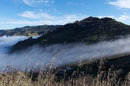
Le lendemain matin nous avons repris la route, juste devant notre auberge il y a un chemin qui monte sec dans la motagne et qui va jusqu'au camping "El Cedro" dans le Parc National Guarajoney, annoncé à 4kms5. C'est là que la partie la plus intéressante du parcours commence. La montée est rude, très rude mais le décor qui était très aride jusque là devient tout à coup très très vert on se croirait limite en Thaïlande. Les 4kms sont interminables vue la montée et les gros sacs sur le dos mais à l'arrivée se trouve le camping El Cedro avec sa buvette pour reprendre des forces. Nous avons planté notre tente là-bas pour 3 jours pour pouvoir rayonner dans le Parc National Guarajoney. Ce parc est magnifique et très très vert avec énormément de lichen qui pend sur les arbres, c'est vraiment très beau. Ce qui est incroyable c'est de voir autant de vert alors que l'île est très aride comme les canaries en général. Bref durant trois jours nous sommes resté à El Cedro, petit camping sans prétention, la patronne est un peu spéciale et la nuit on entend pleurer une meute de chiens ce qui est un peu flippant mais en dehors de ça le camping est idéalement situé et il y a tout ce qu'il faut pour se restaurer. Au mois de septembre nous étions que 3 tentes donc on ne se marchait pas dessus du tout et c'était très calme.
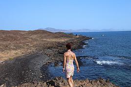
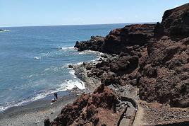
Après avoir marché 3 jours dans le parc nous avions vraiment la flèmme de tout redescendre pour rejoindre une autre destination. Nous nous sommes donc joint à 2 allemands qui avaient une voiture de location pour redescendre. Nous ne savions pas trop où aller alors ils nous ont déposé à Playa de Santiago. Malheureusement pour nous il n'y avait rien du tout à faire ni à voir. Nous avons donc repris le stop et 5 minutes après nous étions en voiture avec un couple d'une cinquantaine d'année qui venait de Gran Canaria. Ils nous ont déposé à Valle Gran Rey. Le décor est superbe, ambiance plage avec bcp d'allemands, voir même que des allemands. C'est l'endroit le plus touristique de l'île donc ca n'a pas était très simple de trouver où dormir. Nous avons trouvé une chambre dans un Hotel face à la mer mais bon, pas du tout l'ambiance que l'on recherchait. Nous y sommes resté 2 jours pour profiter de la mer et visiter la ville (à voir absolument les petites ruelles sur le village dans les hauteurs, vraiment très beau, le port aussi est très beau. Le bord de mer était rempli de raies assez impressionnantes. De là 2 jours après nous avons rejoint San Sebastian en bus pour reprendre le ferry dans le sens inverse. San Sebastian n'a rien d'extraordinaire mais le vendredi en fin de journée la place est remplie d'enfants après l'école et les parents sont tous aux terrasses des cafés, il y a des centaines d'enfants c'est vraiment impressionnant. Voilà, je vous souhaite de bonnes vacances, profitez du Parc National Guarajoney car c'est vraiment très beau.
Voici quelques photos : https://www.flickr.com/photos/nicomikko/albums/72157686554545030
Serait il plus facile si je campe sur itineraire periode janvier Sauriez vous si je peux dormir plusieurs nuits refugio ALTOVISTA sur TENERIFE Parque National…
Souhaitant faire de la randonnée sur cette île, je voudrais d'abord savoir quelle serait la période la plus favorable sachant que j'avais passé quelques jours…
Avec mon compagnon nous partons sur l'île de La Gomera, aux Canaries, durant deux semaines début décembre. Auriez vous des idées de randonnées à y faire? Je…
Nous avons prévu de passer 15j début mai à La Gomera uniquement pour randonner et visiter l'île. Nous aimons prendre notre temps et ne pas courir pour tout…
Cet été nous partons 3 semaines aux Canaries, essentiellement pour randonner. Les guides Rother sont réputés - nous ne les avons avons jamais utilisé - mais…
Bonjour,
Nous souhaitons faire le trek de 4 jours reliant Mestia à Ushguli sans agence. Il est précisé dans les descriptifs qu'il existe des hébergement à chaque étape, mais on ne trouve pas d'info sur ces hébergements. Quelqu'un a-t-il des infos et un avis sur ce parcours?
We're planning to trek in Peru and Bolivia and would love to find some local agencies.
If you know any, could you share details on prices and, of course, the names of the agencies?
Which trek would you recommend?
Elocine
Je pars en autonomie totale sur un trek au Maroc (10jrs) Imilchil - Aghbalou.
Trouve t-on des cartouches gaz à vis (Coleman, Primus) à Marrakech (adresse) ou villages entre Imilchil - Aghbalou ?
Si non , trouve-t-on des cartouches Butagaz pour camping-gaz (petit volume 230 gr ...)
Merci d' avance pour vos réponses
Hello, I’d like to embark on a little trip in my home country, Switzerland. I’ll start walking from La Cure, heading toward Le Noirmont first, then I’ll improvise my route—but it’ll probably follow the French border... at least as far as Lac de Joux.
I’ll decide day by day how much farther to go after that. My goal is to stay in nature as much as possible, wander around for as long as I can, and restock food in villages or towns along the way.
I’m thinking of mostly camping, but we’ll see if I end up in a hotel or another campsite depending on my route.
I’d love to reach La Chaux-de-Fonds on foot... maybe even Delémont.
The whole thing should take about a week, give or take.
I’ll be bringing my dog, and I’m preparing for this as soon as I’m ready.
Any tips to make sure everything goes smoothly for us? Things I should know—or avoid? What about shepherds with their flocks of sheep? And isn’t hunting season open right now?
I’m not sure if what I’m planning is even doable, which is why I’m asking around.
This’ll be my first time doing something like this—wandering in nature *and* with a dog. I’m really excited for this adventure... and I need it. Thanks!
We’re really keen on ecosystems and want to hike in "natural" ancient forests—not planted woods or areas heavily degraded by human activity. Travel guides (like Lonely Planet) don’t provide much info on this. Could you point us to the most interesting spots?
Thanks in advance for your tips.
We wish you happy holidays and a fantastic 2026, full of discoveries!
Claire and Albert
Hi, this might not be the right section, but I’d like to know if it’s possible to start mountaineering with another person without necessarily hiring a guide. We’ve done quite a bit of hiking but not mountaineering—we’ll just do a half-day glacier course. After that, we were thinking of starting with La Grande Motte and the Pointe de la Traversière, which were recommended to us. Honestly, for things like roping up and knots, I’ll learn at home with lots of videos and a book.
Hi,
I don’t know Switzerland at all and was wondering if Vallée des Joux and especially Dent de Vaulion are packed early in the morning or late in the afternoon in July and September?
If so, do you have any quieter spots to recommend in the area, or in Luxembourg (yes, I know it’s not the same country 😉)?
Thanks a lot!
I’m starting this thread—lots of travelers here have done this trek.
When RMS is mentioned, it’s this agency: Ruwenzori Mountaineering Services (with an *s*), because there’s another one online called Ruwenzori Mountaineering Service (no *s*).
Their site:
www.rwenzorimountaineeringservices.com/
From what I gather, it’s the local mountain guide agency certified by the government?
Jaimerais savoir si quelqu'un aurait fait des treks sur le Ruwenzori et combien ça coute en moyenne, les infrastructures, les paysages la sécurité sur les lieux, merci beaucoup. J'attends avec impatience vos réponses.
We’re leaving in 9 days for a two-week trip to Madeira, mainly to hike.
From my research, I’ve found that since last year, access to most trails—and systematically for the most popular ones—is now paid. You have to pay an access fee of 4.50 € per person per classified hike in 2026, and even 10.50 € for the most iconic hike: Pico Arieiro to Pico Ruivo. When paying, you also have to choose a day and a 30-minute time slot for your start time. Of course, this reservation is neither changeable nor refundable, even if the weather that day is terrible.
Personally, given the massive influx of tourists to the island in recent years, I don’t mind paying a fee to help maintain the trails. Similarly, setting a limit on the number of people who can hike them per day is certainly preferable to preserve this priceless heritage.
However, what’s much less fair is that in reality, most of the available spots are reserved: 1/ for Madeira residents (which is normal); 2/ for "economic operators" (meaning local tour operators). For example, if you’re a non-resident (independent tourist), no booking is possible for the Pico Arieiro hike for an early morning start before September! So, unfortunately, we’ll have to skip this hike.
It’s the same issue for Ponta de São Lourenço, the 25 Fontes, Pico Ruivo... in short, all the most popular hikes. Oh well, we’ll skip those too!
So my question is: which hikes do you recommend where we won’t face the huge crowds that the others get? And where we can book the day before for the next day, taking the weather into account?
Finally, a quick accommodation question: we’ve booked the first week in Funchal, but I haven’t decided yet for the second week. Do you have any advice on where to stay in the south or north, preferably avoiding overly concrete-heavy and touristy spots?
I’m reposting about the logistics for Samaria Gorge.
I’d love to get recent info, especially about whether it’s possible to park my car in Omalos, do the hike, and then catch a bus back to my vehicle.
In theory, it’s doable, but when you check the KTEL website, there aren’t any feasible schedules listed. If anyone has recently organized this with reliable, verified details, I’d really appreciate it. Thanks in advance!
Hi there,
We’re flying from Montreal to Lyon this August to go hiking in the French Alps. We’ve rented a car and will be staying at campgrounds. We’re planning to do day hikes and want to stay a few days in one spot, do a few hikes, then move on to our next camping spot. Could you share your favorite spots or any recommendations for places to spend a few days with great hikes?
A few details:
We arrive in early August and leave in early September.
We’re looking for day hikes (or shorter), moderate difficulty, with a cumulative elevation gain of no more than 1000m, and of course, beautiful scenery!
We’d prefer not to drive too much—maybe it’s best not to head too far south and deal with unnecessary heat?
Along the same lines, if you know of any great campgrounds where we can start our hike directly without needing the car, we’d love to hear your suggestions!
Bonjour
Souhaitant faire de la randonnée sur cette île, je voudrais d'abord savoir quelle serait la période la plus favorable sachant que j'avais passé quelques jours en novembre 2018 pas pour cette activité mais plus pour une simple découverte de l'île et le temps n'était pas top notamment en montagne. Donc peut on choisir une organisation en étoile sachant que je louerai un véhicule avec éventuellement 2 points d'hébergement.
Je n'envisage pas d'intégrer une structure mais de partir à 2 et de s'organiser sauf si vous me conseillez une agence locale ou un guide local. Enfin même si je compte me procurer les différents supports, carte et topo guide plus gps je vous remercie de bien vouloir me communiquer les randos à faire en priorité
Merci beaucoup pour vos informations
I’m planning to do the Mercantour crossing following the Randoxygène route in mid-July.
I’m used to hiking in the mountains, but I sometimes get vertigo, for example on ridges with drops on both sides. I wanted to check if there are any T4 or T3-T4 sections and find out if there are any very exposed passages—and if so, where—so I can plan an alternative route.
Can anyone give me some info on this?
Thanks!
I’m planning a trip around Cap Corse and the AGRIATES in 2026, from May 8th to 15th (there are still 2 spots left, by the way! Just DM me if you're interested).
I’d love to know which hikes are worth prioritizing in the AGRIATES. We’ll be staying in SALECCIA for two days as our base—what should we focus on from there?
A round trip to IGNHU beach? Any other suggestions?
For Ostricano, I think it’s too far for a round trip...
Thanks for your tips!
Have a great day,
Anie, Toulouse
I’d like to get some info about the GR10 Pyrenees traverse. I need help planning the daily stages and accommodations—my wife isn’t an experienced hiker but walks a lot, so I’d like to schedule shorter walking days and thus a longer overall trip in terms of number of days.
Could anyone give me some help and advice?
Best regards,
New to this forum, I’m planning a pretty big project for 2028.
I’m heading to Nepal to do a trek from Kathmandu all the way to Everest Base Camp (a cool 5,300 m 😄).
This trek is a bit special because even though I’ll be part of a group, I’m going solo (so far, no problem—I’m used to it). But it’s my first real trek, and it’s also a humanitarian one: once I reach base camp, I’ll stay an extra week to help clean up the waste left by tens of thousands of climbers! Since I’m originally from South America, from two countries that share the Andes, I have a deep respect for mountains—they fascinate me. So Everest… it’s kind of the trip of a lifetime!
So, a little question for those who’ve done treks to Everest before… any tips for good mental preparation (I’m already working on the physical side)?
Hi there, I’m planning the Annapurna Circuit for March 2027 and I’m looking for a local agency with a local guide—preferably French-speaking—to arrange this trek for us. Any suggestions? Thanks
Hello!
We’re spending a few days in Toraja country at the end of May. We’d love to do a day trek—taking our time—on a route that’s stunning in terms of scenery, but not a level 5 in difficulty!
Any suggestions you can share, please?
Thanks in advance
I’d like to do the Mare a Mare Sud in May over 4 days. I’ve found quite a few places to stay along the route, but I’m stuck on the start and finish.
I’ll be arriving by plane on Sunday evening and would like to start pretty early on Monday morning. Ideally, accommodation right at the trailhead (Alzu di Gallina) would be amazing, but I can’t find anything. Any tips?
Also, for the transfer from Figari Airport to Porto Vecchio or Alzu di Gallina?
At the end, I’d like to pick up a rental car—any advice on that too?
I’m traveling solo by plane to Catania in May and plan to hike the northern side of Etna, starting from Linguaglossa where I’ll arrive by bus. After that, I’d love some info on how to get up to Piano Provenzana (shuttles or hitchhiking), since it seems there’s no public transport except in the summer. Can you sleep there in a free or cheap refuge, or camp? And how far up can you go without having to hire a guide? Thanks in advance. Bernard.
Bonjour a tous,
je pars en voyage au Maroc en aout et nous allons commencer par nous arrêter a Chefchaouen(nous sommes en voiture).
Ma question: quelqu'un peut il m'indiquer un itinéraire de rando en boucle d'entre 5 et 7 jours aux départ de Chefchaouen dans le parc de Talassemtane passant si possible par le pont de dieux?Ou un guide papier qui en reunis quelques uns?
Nous privilégions le camping sauvage et les gites.
Merci d'avance
Hi there, for those who’ve been recently—is it possible to find other solo travelers in March on the island to share transport or room costs? It doesn’t seem easy to travel on a budget.
If you have any recommendations for simple lodgings or places with dorms, I’d love to hear them.
For those who’ve done multi-day treks while moving around: do you need to bring your own sleeping bag? I’d love to hear about itineraries you’ve done without a guide, just with a map and GPS.
Thanks, and have a great day!
Hi everyone!
We’re planning a 15-day road trip to Scotland this summer, specifically to explore and hike on Lewis and Harris—places we’ve never been before. We’ve visited other islands on previous road trips in Scotland (we usually go in April for a week). This would be our first time in Scotland in the summer and for 15 days. We’re looking at late August to early September.
I’m currently drafting the itinerary. We’d be crossing from Ullapool and were thinking of spending 3 nights on Harris and 4 nights on Lewis.
Does that sound balanced to you? Is it better to keep the same accommodation on Harris and the same on Lewis to explore the area? I’d love to hear about any past experiences you’ve had on these islands.
Thanks!
Hi there, I’m trying to leave for 15 days very soon to São Vicente. I’m either looking to join an agency or figure things out on my own to go hiking on one of these islands or both. From what I’ve seen, it’s not easy to organize with local transport, so it gets expensive. Can I use the services of a small local agency? I’m looking for the simplest way to hike for several days. Also, how do you get from São Vicente to São Nicolau? Thanks in advance and have a great day!
Aichatou
I’ve been wanting to do this for several years, and this year’s the one. Next September, I’ll be trekking in Tusheti (Georgia), from Omalo to Shatili.
Of course, I won’t be renting a vehicle that’d just sit unused. No problem getting to Pshaveli, but from there to Omalo, it’s a dirt road (still the case?)
There must be some form of public transport since there are so many guesthouses, and not all travelers come in a 4x4.
If any of you have been to Omalo, could you confirm that these shared transports exist and how often they run?
we’re planning a trip to Yellowstone and hoping to do a three-day backcountry hike if we get a permit.
if any of you have done this before, could you let me know if it’s possible to find water along the way? And if we can transport it, are we allowed to use a stove?