Who are you? Where are you from? Where are you going?
Like last year at this time, a post about bike travel ideas.
How many of us are preparing a trip planned for this year? Probably a lot.
What’s yours—the one you’ve been dying to do for so long, maybe too long? For us, it’s a modest PARIS-MARATHON by bike, followed by MARATHON-ATHENS on foot in June 2010. And you?
May the passion keep growing before, during, and after! Happy planning and safe travels to everyone.
30 similar discussions in English
Hey everyone, travelers! Here’s a little post to share our bike trip this summer. We did the Via Rhôna from Geneva all the way to the Mediterranean Sea. It was a truly amazing adventure—no hitches, lots of independent greenways, and we felt like we had the Rhône all to ourselves as our guide for 700 km over 7 days. That averages out to 100 km a day. We thought we’d do less, but the Via Rhôna is flat and not too tiring, which let us push to around 100 km each day!
Here’s the full video of our route: www.youtube.com/watch?v=x_cpBro6Df8
We’re not seasoned cyclists—we just love biking, and this trip was our first big bike touring adventure. As for our bikes (see photo), we had road bikes, sturdy ones with fairly large wheels and rear racks for our gear.
Speaking of gear, here’s what we brought: just the essentials for 7 days of biking and camping—1 tent for 2, two sleeping bags, a few clothes (not too many), 1 book each, toiletries, phone chargers, a basic bike repair kit... and maybe 2 or 3 things I’m forgetting. The idea is to travel light so you’re carrying as little as possible!
We camped every night. Along the Rhône, it’s pretty easy to find campgrounds, and they’re cheap too! Each morning, we’d decide on our destination for the evening (usually based on available campgrounds) and call during the day to book. We always managed to get a spot right away (except when we reached the Mediterranean coast, but we should’ve seen that coming 😛).
For expenses, we slept at campgrounds (between 15 and 25 € per site for 2) and either picnicked or ate at restaurants. Other than that, there weren’t really any other costs besides a few small souvenirs here and there. In total, we spent about 500 € for two over 7 days (so 35 € per person per day). I think it’s possible to spend even less—we decided not to restrict ourselves when it came to restaurants and campground prices.
For us, the most beautiful part was between Geneva and Lyon! The Rhône is still a bit wild there, as are its banks. Not too many roads, highways, trains, or factories around—just nature and peace. You gradually leave the Alps behind and head further south. It was truly stunning. We also loved the "Rhône Valley" after Lyon. The succession of dozens of suspension bridges and little villages, each more charming than the last, really enchanted us.
The trickiest part was leaving Lyon... The Via Rhôna disappears for a long stretch, forcing you to alternate between roads, traffic, danger, and pollution. We had to wait until Givors, further south, to finally get back to the quiet bike path and the Rhône showing us the way. Also, after Lyon, the Rhône becomes a bit more industrial—you pass by dams, factories, and power plants more often. But it’s really just a small detail, the exception that proves the rule of this magnificent Via Rhôna.
The Via Rhôna is a fantastic way to see how water from the mountains of Lake Geneva flows, travels, and winds its way for hundreds of kilometers to reach the sea. With this trip, you get closer to the Rhône—it becomes your accomplice, your guide. Plus, you cross a beautiful part of France, with its charm and little villages. It’s the France we love, and it’s great to explore your own country like a tourist.
That’s it for our little travel journal. I didn’t go into too much detail about our days since everyone will follow the same route, and everyone can go at their own pace :) But I’m happy to answer any questions (logistics, technical stuff, routes, etc.)—I’d be glad to help!
Here’s the video of our route again—I also composed the music, so I hope you’ll like it: www.youtube.com/watch?v=x_cpBro6Df8
Happy travels,
Flo
This message is for folks who’ve been to Cayo Jutias in the past year, especially this past winter. I’d love to hear about the road conditions on the way there. Are the last few kilometers to the beach still in terrible shape, full of potholes?
Same question about the road through La Sabana toward Santa Lucia—was it still in rough condition?
How’s the road to Minas de Matahambre and Pons?
And what about the route from Santa Lucia to Mantua and then Sandino?
Thanks in advance.
Same question about the road through La Sabana toward Santa Lucia—was it still in rough condition?
How’s the road to Minas de Matahambre and Pons?
And what about the route from Santa Lucia to Mantua and then Sandino?
Thanks in advance.
Hi there,
I’m looking for route ideas for a 5-day bike trip in the Spanish Basque Country, max 40 km per day and 500 m of elevation gain max per day, preferably on greenways or small roads for August 2025.
I’d also love to hear your thoughts on the weather: does it rain a lot at that time of year?
We cycled along the Finistère coast last summer but managed to dodge the rain 😄.
Thanks in advance for your tips!
Hi everyone,
I’m trying to figure out how to get from Paris to Marseille or Montpellier with non-disassembled bikes by train in early July 2025... and it’s a total flop!!! Can’t find any trains that offer the bike-on-board option! It’s so complicated between SNCF-CONNECT, OUIGO, and TER INTERCITÉS!!! Nothing’s simple! I want to take my teens and their cousins on a bike trip to the Camargue, but I’ll have to start planning way ahead to sort out bike transport!!! So glad I found VoyageForum for tips! !
I’m trying to figure out how to get from Paris to Marseille or Montpellier with non-disassembled bikes by train in early July 2025... and it’s a total flop!!! Can’t find any trains that offer the bike-on-board option! It’s so complicated between SNCF-CONNECT, OUIGO, and TER INTERCITÉS!!! Nothing’s simple! I want to take my teens and their cousins on a bike trip to the Camargue, but I’ll have to start planning way ahead to sort out bike transport!!! So glad I found VoyageForum for tips! !
😎Fellow traveling cyclists or not, all of you who love travel, the pleasure of physical effort, nature, beautiful machines, people with true passions they seek to fulfill, and who also enjoy reading great literature about all this—the *200* magazine is for you just as it is for me. I should mention I have no financial or other interest in this (in an era where we accuse our politicians of all sorts of vile interests, I prefer to take precautions). I’ve been subscribed since the beginning, and every three months, I get my 130 pages of dreams (the magazine just went from 110 to 130 pages).
It covers everything from the trans-America route to the TCR (Trans Continental Race) from Belgium to a small town in Turkey, with mind-blowing averages—4,000 km and 80,000 m of elevation gain in 8 days and 15 hours for the winner. Let that sink in, and all of it without assistance—accepting a patch could penalize you. There’s also a story about crossing Iran, encountering one of the world’s most welcoming populations, following in the footsteps of Nicolas Bouvier, as well as retirees leisurely traversing France. The common thread in all these stories? Beautiful writing. Take, for example, a stunning article: *"Passengers of the Cold: From Edinburgh to Thurso, at the very north of Scotland, 550 km of moors, coasts, and icy wind. In Thurso, the road ends at a quay, facing the Orkney Islands. We wanted a November trip, off-season. We wanted to surprise winter. Just before the snow."* A sublime piece on the experience of facing adversity and the chance encounters along the road and in the elements.
Before I embarked on my own bike trips, I dreamed a lot about them—from the Atacama to the Gobi, along the Mekong, and not forgetting France. And now, these 130 pages every quarter keep those dreamy vibes alive through stories written in the most beautiful prose.
I’ll stop here because it might sound like I’m advertising, but if you don’t know *200*, I invite you to discover it. It’ll give you wings for the most incredible challenges or simply reinforce your desire for slow rides with your eyes open to others and nature.
A little news to wrap up: Axel Carion and a friend just broke the record for crossing South America from Colombia to Ushuaia in 59 days. On its own, that doesn’t mean much, but I can’t help it—it makes me dream. You should see how he talks about it, the flashes of that wild nature he’s stored away: a snowstorm at Paso Jama and the surreal sight of the suddenly snow-covered Licancabur!
Luc PS: The magazine is called *200* because a day’s ride starts at 200 km—well, I’ve never done a ride like that since my longest was 167 km (with 18 kg of luggage, mind you), but why not one day? The magazine will explain how to tackle your first 200, and then the question in conclusion: when will you do your first 300?😏
Hi there,
Coming from Laos (*), I’m planning to enter Thailand by bike via the Fourth Thai–Lao Friendship Bridge.
Before this bridge was built, I’d already cycled the road from Louang Namtha to Houei Sai and crossed the river by boat to reach Thailand.
At the time, the condition of that road was impeccable, and most importantly, traffic was light.
So I’m wondering if anyone who’s taken it recently can tell me whether traffic has increased since the bridge opened.
Thanks in advance!
(*) I’m currently cycling in China (Yunnan)
Hi there,
Has anyone here cycled in the Canary Islands in August? Is it not too hot? Not too crowded on the roads?
Thanks
Hello, I spent a month cycling in Thailand earlier this year with a touring bike equipped with two rear panniers. I loved being able to ride and stop at a hotel every night, and eat just about anywhere. I tried India two months ago but gave up because of the road conditions and chaotic traffic.
I’m looking for countries where I can cycle "without autonomy"—so no tent, no stove, just the bare minimum. Ideally, I’d like to stop at hotels or similar accommodations regularly, without having to cover 200 km a day!
I’d love to hear from your experiences—what countries make it easy to travel this way? Thanks!
A firsthand account of a 30-day cycling trip (the length of the visa) in southern Vietnam, from Hue to the Mekong Delta. 1,500 kilometers pedaled in December 2022 and January 2023.
Roads and Traffic The roads are generally in very good condition. The secondary road network is limited. Since Vietnam is a densely populated country, needless to say, traffic is often heavy, including on secondary roads. Cyclists, along with pedestrians, are at the very bottom of the road-user hierarchy. In short, when you're on a bike, you never have the right of way. The atmosphere is deafening—Vietnamese people honk all the time. For a Western ear, it's hard to tell the difference between a honk that just signals someone's presence, one that warns of imminent danger, or an angry honk. 😏
Weather Vietnam is a long, narrow country (1,600 km). The weather isn’t the same in the north, center, or south. I cycled through the central part in December. Even though the monsoon peak had passed, I still encountered a lot of rain. Since the monsoon usually lasts until January, it might be better to cycle there starting in February. I was in the Mekong Delta in January. The best season, as it’s the driest month with the least hot temperatures. At this time of year, the prevailing winds come from the northeast. So, it’s better to travel from north to south. That way, you’ll usually have the wind at your back.
Accommodation I always stayed in hotels without ever booking in advance. Typically, I paid between 10 and 20 € for a double room with a private bathroom and AC. To find hotels, I used Google Maps and Maps.me. Wi-Fi is available for free almost everywhere.
The Route Hue → Danang → Hoi An → Nha Trang → Phan Rang → Tan Son → Dalat → Di Linh → Mui Ne → La Gi → Vung Tau → Nha Be → My Tho → Tra Vinh → Can Tho → Cao Lanh → Tranh Hoa → Trang Bang I took the train from Danang to Nha Trang. Not all trains accept bikes, so you’ll need to check beforehand. The railway handles bikes—they’re packed by staff and travel in the same train but in a freight car. I paid 14 € for the ticket plus 7 € for the bike (there’s an extra 0.50 € to pay upon arrival).
The Verdict So, is cycling in Vietnam worth it? If you enjoy biking in traffic, then yes. Otherwise... 😎
Hi, I'd like to know if anyone has done this route recently or has reliable info.
Does the track exist, and most importantly, is there sand (for biking)?
Any info is welcome.
Cheers,
diego ambilobe: mangaoka, manondro, ramena vohemar sambava: masondrono, tanambao
diego ambilobe: mangaoka, manondro, ramena vohemar sambava: masondrono, tanambao
Hi there,
I’d like to cycle around Guadeloupe during the Christmas holidays. I was wondering if it’s dangerous, if it’s easy to rent a bike, and to find accommodation along the way? Thanks!
Hi everyone,
First post here to share a quick recap of our west-to-east bike trip along Algeria’s coast in January 2025. It was just the two of us—my partner and I—with French passports and not a word of Arabic. No friends or welcoming hosts in the country.
Under those conditions, we’d strongly advise against going.
Our original plan was to follow the coast from Algiers to Tunis. We ended up cycling from Algiers to Béjaia, then took the train from Béjaia to Annaba (with a stop in Constantine), and finally biked to the border. We were tailed by police the whole way—whether on our bikes, on the train, or even on foot while exploring towns. On top of that, we couldn’t wild camp and were limited to the few state-approved hotels that accept foreigners. Under those circumstances, connecting with locals was especially tough.
With such an omnipresent and intrusive police presence, we’d definitely recommend against this destination for bike touring. A really sad situation that completely cuts you off from the local population...
We’d been warned, we went to check it out, and we weren’t disappointed!
You’ve been warned.
Hi, I’m looking for info on doing a solo bike trip from Chelyabinsk to northern China via Omsk. What’s the best time of year to go? Can I do it staying only in hotels and restaurants—without having to haul a tent, stove, etc.? Also, is there a border crossing point in northern China, because I can’t find anything on Google Maps? What’s the road condition like? Thanks
Hi there,
Last summer, I cycled through the Lot and Célé Valleys. There were two couples of us, in "camping mode," with hybrid bikes (except for one road bike with tires that weren’t hybrid at all (!) plus a Bob trailer). We completed the route in the first half of July in just under 15 days (allowing time to explore along the way). The odometer totaled 550 km. We started in Aiguillon on the Lot River and finished in Saint-Geniez-d’Olt. It was an absolute delight. First off, a big thank you to everyone who helped us plan this trip by sharing tips, favorite spots, and practical guides—there were many, and some will recognize themselves (a Jakez from Brittany, a local postman, etc.). A major project seemed to have been launched, but since 2011, not much has materialized beyond Cahors (a signposted cycle route). Don’t let that stop you—it’s totally worth it! In return for the great tips we received, I’m happy to help anyone considering the same route with details on the itinerary, stages, road conditions and traffic, campsites, highlights, and more. Best regards,
Pierre from Lorient
Hi there,
I’m planning to build a new touring bike. I want to prioritize lightness. That said, I’m tempted by a suspension fork that could offer some comfort on rougher roads. The recent appearance of gravel suspension forks on the market might meet my needs—at least on paper. I’m particularly considering the RockShox Rudy Ultimate XPLR fork. Unlike MTB forks, its travel is short: either 30 mm or 40 mm. It weighs 1400 g, which is 400/500 g more than a steel fork.
Any thoughts or real-world feedback on this?
I’m also wondering about the durability of magnesium (lower leg) for long-distance bike touring. And what’s the impact of skipping the manufacturer-recommended maintenance every 50 and 200 hours? That’s bound to happen on a long trip unless you carry extra gear. More generally, how reliable are these kinds of forks?
Thanks in advance
Hi there,
Just a few words about the loop I did by bike in Yunnan.
Entry and exit
I entered China through the Sino-Vietnamese border crossing at Lào Cai / Hekou under the 30-day visa exemption currently available to French nationals and others.
The process was simple and quick. A Chinese police officer even helped me complete my electronic pre-registration at a computer kiosk. I wasn’t aware this formality was required—it’s similar to Thailand’s TM6.
No issues with the bike.
I left the country via the Sino-Laotian border crossing at Mohan / Boten.
The atmosphere was a bit chaotic there, but again, no problems with the bike.
The timing
I visited Yunnan in February 2026.
Weather-wise, at higher altitudes (between 1,500 and 2,000 meters), it was around ten degrees at night and in the mornings, and around twenty degrees at the hottest part of the day.
I had two days of rain, so I took the bus to keep moving. Otherwise, clear blue skies.
Culturally, Chinese New Year fell on February 17th (and the 15 days following), right in the middle of my trip. Because of this, my take on the traffic might be off.
Accommodation and food I always found a hotel to stay in for prices ranging from 8 to 15 €. Except in Kunming (the capital), where many hotels were fully booked (Chinese New Year). I ended up at a 100 € hotel with great value for money.
A bowl of noodles costs about 1.5 € on average.
Onboard electronics Since my smartphone doesn’t support eSIMs, I subscribed to a China plan with my carrier. Otherwise, for much cheaper, Alipay offers eSIMs for foreigners that allow access to services usually blocked for Chinese users (WhatsApp, Facebook, etc.).
An internet connection is essential for paying with Alipay or WeChat, as this payment method is widespread.
I only managed to use Alipay.
Either way, always carry cash because sometimes there’s no signal, or the merchant only accepts WeChat.
Also, it’s best to bring a power adapter when you arrive rather than struggling to find one.
Traffic and roads The Chinese aren’t reckless drivers. They follow traffic rules and watch out for cyclists. This is slightly less true in Xishuangbanna (the region bordering Myanmar and Laos).
In urban areas, there are almost always wide bike lanes, separated from other roads, where bikes, electric mini-scooters, and scooters share the space pretty harmoniously.
The roads are in great condition, and traffic is generally manageable—even light—except for one stretch (Eshan -> Yangwu).
Most traffic is absorbed by expressways, China’s equivalent of highways: toll roads that are off-limits to slow vehicles.
You’re never far from these expressways; sometimes you even ride alongside them, which can be noisy at times.
The climbs are usually reasonable, around 5% to 6%. From what I remember, the steepest section was between Menglun and Mengla, with gradients of 8% to 10%, sometimes more.
Riding at these altitudes—though modest—took a bit of getting used to.
The route I didn’t plan anything in advance. My only goal was to reach Kunming. I don’t know why, but just hearing the name of that city, like Yunnan, always felt dreamy to me.
Here’s the breakdown: Hekou -> Man Hao (94 km); Man Hao -> Yuanyang (64 km); Yuanyang -> Jianshui (bus); Jianshui -> Tong Hai (78 km); Tong Hai -> Chenjiang (85 km); Chenjiang -> Kunming (60 km); Kunming -> Kunyang (60 km); Kunyang -> Eshan (67 km); Eshan -> Yangwu (58 km); Yangwu -> Yuanjiang (59 km); Yuanjiang -> Pu'er (bus); Pu'er -> Dadugang (75 km); Dadugang -> Jinghong (80 km); Jinghong -> Menglun (67 km); Menglun -> Mengyuancun (51 km); Mengyuancun -> Mengla (43 km); Mengla -> Boten (67 km).
Otherwise, I’m currently in Thailand and just hoping my return flight with Qatar won’t get canceled.
Oh well... 😉
Hi there, we’re planning a Munich to Venice bike trip at the end of June 2026. Getting back from Venice to Toulouse by train with 4 bikes isn’t straightforward. What return options have others who’ve done this trip chosen? Any tips or great deals would be much appreciated. Thanks a bunch! !
Hi everyone,
I’m planning a cycling trip in Algeria and looking for concrete firsthand accounts from cyclists who’ve recently traveled there (or residents who know the terrain well). My goal is to map out a realistic 2–4 week itinerary that prioritizes discovery, safety, and solid water/bivouac management.
My profile and gear
Semi-bivouac autonomous cyclist (light tent + sleeping bag + stove), with the option of simple accommodations in towns.
All-road/gravel bike with a rear rack, 40–45 mm tires (I can go up to 47–50 mm if needed).
Compact drivetrain with a small gear range for climbing while loaded.
Modular water capacity of 4–7 liters (soft flasks + bottles), plus a filter and purification tablets as backup.
Navigation via offline maps + GPS, GPX tracks if available.
Planned period
Late winter/early spring (timing to be refined based on your feedback about weather, wind, and day/night temperature swings). I’d love a seasonal breakdown: which areas are more pleasant/rideable during this time? Are there zones to avoid while others become ideal?
Preferred itinerary style
High plateaus and accessible Saharan fringes for a loaded bike, alternating between secondary roads and rideable tracks.
Moderate pace (60–90 km/day depending on terrain and wind), with stops in resource towns to restock, shower, and rest.
Safety and logistics (water/supplies) take priority over pure athletic performance.
My specific questions for those who’ve cycled in Algeria 1) Routes and areas
Which roads/tracks did you enjoy for their scenery and interest without being too rough for a loaded gravel bike?
If you’ve ridden the high plateaus: which connections do you recommend to avoid traffic and stick to small roads?
Saharan fringes: which sections are realistic for partial autonomy (reasonably spaced water points, rideable tracks, not too much soft sand)?
Areas to avoid by bike (recently) due to security, road conditions, katabatic winds, construction, etc.?
2) Water and supplies
How frequent were water points on your routes: reliable wells? taps? sources in towns/villages?
In “desert” sections, how many liters did you carry between secure points? Does a 6–7 L capacity seem comfortable, or should I aim for more on certain stretches?
Food: small shops, markets, availability of basics (semolina, sardines, dates, biscuits, powdered milk, etc.) — how often can you reasonably restock?
Filtration: did a filter + tablets suffice? Are there areas where you’d advise against filtering from unprotected wells?
3) Bivouacking and accommodations
Tolerance for discreet bivouacking (far from dwellings, leave-no-trace): recent experiences?
Simple alternatives: guesthouses, small hotels/hostels, campgrounds (if any), municipal lodgings?
Practical stopover towns for restocking, resting, and securing your bike overnight: reliable spots or neighborhoods to prioritize/avoid?
4) Roads, tracks, and weather
Road surface quality on secondary routes: generally decent or highly variable?
Tracks: rideable (compact gravel, laterite) or sometimes sand/washboard? At what tire width would you recommend switching (45 vs. 50 mm)?
Prevailing winds this season: direction, strength, most exposed hours; do you adjust your departures to ride “before the wind” in the morning?
Temperatures: day/night range; sun protection (long gloves, buff, sunscreen, sunglasses), managing nighttime cold at altitude or in the open desert.
5) Safety, formalities, and connectivity
Recently discouraged zones (please note the date if possible).
Roadside checks: which documents to keep handy; are there specific registrations or declarations required upon arrival or when moving between wilayas?
Local SIM/data: which operators work well on the routes you took; tips for recharging/buying credit.
Useful apps/maps on the ground (and reliable offline maps) for locating water, grocery stores, garages, accommodations, rideable segments, etc.
Bike security: how did you handle anti-theft and parking during errands/overnight stays?
6) Gear and adjustments
Recommended minimum gearing for loaded climbs on local roads/tracks.
Ideal tire width and casing (puncture resistance on gravel and rocks).
“Sweet spot” water capacity based on your experience (and tips: frame bags, extra bottles on the fork, bladders in frame bags, etc.).
Maintenance: dust/sand — greases/seals, drivetrain cleaning frequency, breathable filters, protective socks for zipped panniers.
Sample itinerary outline (to validate with your feedback)
Week 1: Arrival, adjustments, high plateaus, linking resource towns to get into the rhythm, test supplies and water.
Week 2: Accessible Saharan fringes, alternating road/track, nights in discreet bivouac when possible + simple accommodations every 3–4 days.
Week 3–4 (optional): Extend toward a second Saharan area or head back to a more temperate zone depending on weather/wind, prioritizing routes known to cyclists.
If you have GPX tracks (even partial), waypoints (water, grocery stores, accommodations), or a travel journal with dates, I’d love to see them. Dated info (year/month) will help me weigh what may have changed recently.
What I can share in return
After the trip, I’ll publish a detailed report with:
Final itinerary + cleaned GPX tracks,
List of confirmed water points and open supply spots,
Gear review (tires, gearing, water capacity),
Notes on bivouacking/accommodations and safety,
Budget and daily distances, to help future travelers.
Thanks in advance for your tips, warnings, good addresses, and updated feedback. Your experience is invaluable for planning a safe, smooth, and enjoyable cycling route in Algeria. Happy trails! 🚴
Hi fellow travelers! I’m planning a trip to Japan from March 22 to April 12 and really want to bike the Shimanami Kaido starting from Onomichi, but I don’t cycle regularly. Has anyone here done it and could share their experience or tips? Is the weather in March-April favorable? Should I plan for 2 or 3 days? Electric or regular bike? What’s better—having my luggage forwarded along the route or leaving it in a locker? Any recommendations for accommodations or bike rentals? Thanks in advance for your replies!
I’m planning a journey of about 2500 km starting from San Pedro de Atacama (duration: max. 2 months). This trip, almost entirely on remote trails, promises to be an extraordinary adventure.
Highlights of the trip - Crossing the Florido Desert (during the blooming season: October 15–30) - Hiking ascents of legendary volcanoes: - Ojos del Salado (6879 m) - Llullaillaco (6739 m) - Uturuncu (6008 m, with 5820 m reachable by mountain bike!) - A 300 km stage through the heart of the desert, with no resupply or habitation: the ultimate experience of solitude and self-transcendence.
Practical details - Daily distance: max. 100 km and 1000 m elevation gain per day - Average altitude: 4000 m (between 3500 and 5000 m) - Temperatures: ~15 °C during the day, down to -25 °C at night (in a tent) - Accommodation: ~50% in villages (with locals or small hostels), ~50% camping
Estimated budget - 1400 € for the flight ticket (including bike supplement) - 1000 € for on-the-ground expenses
Required equipment - Fatbike (essential for deep sand) - -25 °C comfort sleeping bag - Single-wheel trailer (indispensable for these tough terrains)
My experience In 2022, I completed a similar 1200 km trip north of San Pedro de Atacama: - Full crossing of the Salar de Uyuni (170 km) - Ascents of the Ollague (5868 m) and Aucanquilcha (6176 m) volcanoes - Two 200 km stages with no resupply or human presence Videos available for a glimpse of the adventure: - Atacama Crossing 2022 - Part 1 - Atacama Crossing 2022 - Part 2
Next steps If this adventure interests you, I suggest: 1. A first phone call to get to know each other 2. A meet-up over a drink or a test ride in the Bardenas Reales (similar terrain, and I live 100 km away)
Don’t hesitate to contact me for more info or to discuss the details!
Hi there,
Last spring, I set off from Villeréal (47) on a road bike and reached the North Cape after 6 weeks of cycling.
I had a particular concept: I’d cycle each stage (averaging 140 km) and then return to the starting point either by carpooling, hitchhiking (not often), bus, or train. I’d meet up with my van (a Trafic) and then drive the same stage to eat and sleep there.
This approach let me choose where I stayed for the night and, most importantly, ride the distance I wanted—my longest stage was 217 km—without carrying any weight, since I can’t imagine doing a fully self-supported bike trip.
I did a first 3-week stretch that took me to the top of Denmark using this method. Then I drove back to Hamburg in my van, left it there, and flew back to Bordeaux.
I spent two weeks at home because my autistic son was staying with me, then my wife and I flew to Hamburg. We picked up the van and drove back to the top of Denmark to catch a ferry to Oslo.
For this second leg, my wife drove the Trafic, and we met up along the stages, which allowed me to focus solely on my ride.
I chose to go through Sweden—it would’ve been much more complicated going up through Norway because of all the tunnels, frequent small ferries to cross the fjords, and a lot more elevation gain.
I had favorable winds most of the time, a few hiccups, but overall everything went smoothly, and I stuck to my route and schedule.
I kept a travel journal on My Atlas—here’s the link: https://www.myatlas.com/danielcramay/du-47-au-cap-nord
Hey Cyclists! So, here we go—departure this Thursday from Giromagny (90), still in bikepacking mode, but this time with my wife’s bike lol.
12 years later, back in the Alps for a crossing all the way to Barcelonnette. From there, I’ll head toward Vaucluse and face Mont Ventoux for the first time 🚴♂️. Until then, the Alps will most likely leave their mark 😅🚵♂️🚴♂️. I’m a bit nervous about the Col de la Colombière—if all goes well, I should leave a wreath there lol! The return after Mont Ventoux should be less traumatic (or maybe not).
A few photos below.
If you’re on my route, it’d be great to chat! ;) I’m also planning to film the ride (as usual), my impressions, etc.
Good luck with your preparations to everyone working on a project, and safe travels to those already on the road! ;) Gilles
Hi there,
We're planning to ride the EuroVelo 6 by tandem this summer for two weeks (16 days).
We're torn between two routes: Passau-Budapest or Vienna-Belgrade. A third option could also be to go from Prague to Vienna and then continue to Budapest.
Which route would you recommend? Is the EuroVelo really crowded in the summer?
Thanks so much,
Camille
Hi there, we’ve been traveling by bike for a year now on the beautiful roads of our amazing planet. We’re currently in Vietnam. After a little 4-month loop through Southeast Asia, we’ll head to Japan and then on to China (which we already crossed in October and November).
Here’s our question: have any of you, or do you know if it’s possible to bike the few thousand kilometers between Beijing and Ulaanbaatar? Is the route allowed by Chinese authorities, who are so welcoming?!
Thanks for your replies! Elise and Brice Our site: http://petitshommesdumonde.free.fr
Here’s our question: have any of you, or do you know if it’s possible to bike the few thousand kilometers between Beijing and Ulaanbaatar? Is the route allowed by Chinese authorities, who are so welcoming?!
Thanks for your replies! Elise and Brice Our site: http://petitshommesdumonde.free.fr
When you think of traveling in Tanzania, you often picture high-altitude treks and 4x4 safaris. However, for those who prefer exploring on two wheels, the country’s vast network of dirt tracks, volcanic terrain, and diverse ecosystems make it one of Africa’s most rewarding cycling destinations.
Whether you prefer challenging alpine climbs, fast gravel trails, or coastal rides, here’s a look at what makes cycling in northern Tanzania so exceptional, along with some of the region’s best routes:
1. Climbing Mount Kilimanjaro by bike (Kilema route) Terrain: Singletracks through humid rainforest, gravel paths in the moorland zone, and alpine desert scree. * The experience: For experienced mountain bikers seeking a high-altitude challenge, the Kilema route is the official bike-accessible path on Kilimanjaro. The trail winds through lush rainforest before reaching the open heathlands near Horombo. Higher up, crossing the alpine desert toward Kibo demands endless bike carries and pushes, but descending through the forest canopy remains an unforgettable experience.
2. The full 360° loop around Kilimanjaro’s base Terrain: Red clay earth, two-track trails, rolling gravel, and volcanic paths (total loop of about 360 km). The experience: Circling Kilimanjaro lets you admire its landscapes from every angle. The route meanders through Chagga farmlands, coffee plantations, dense forests, and the open Maasai plains of the western side (like the West Kili area). It offers stunning views of Kibo and Mount Meru while passing through local villages.
3. From Kilimanjaro to Lake Natron (descent into the Great Rift Valley) Terrain: Technical gravel, dry riverbeds (wadis), unstable volcanic rock, and acacia scrub. The experience: This route takes cyclists from the fertile high slopes of Kilimanjaro to the dramatic, arid scenery of the Great Rift Valley. As you approach Lake Natron, the active volcano Ol Doinyo Lengai (“Mountain of God”) dominates the horizon. The final stretch across the Rift floor leads to the saline, serene shores of Lake Natron, a prime breeding ground for large colonies of lesser flamingos.
4. Wildlife zones and corridors Terrain: Packed dirt tracks, animal trails, and undulating bush paths. The experience: Pedaling through the northern circuit’s wild buffer zones and Wildlife Management Areas (WMAs) offers an authentic off-the-beaten-path cycling safari. Riding through acacia woodlands often provides sightings of savanna wildlife like giraffes, zebras, and antelopes in their natural habitat.
5. Coast to coast: From Kilimanjaro to Zanzibar Terrain: Varied surfaces—from highland dirt tracks to coastal asphalt and sandy island trails. The experience: Combining the cool mountain air of Kilimanjaro with the tropical Indian Ocean coastline, this long-distance route transitions from mountainous foothills to rural towns before ending at the coast for a boat crossing to Zanzibar. There, you can cycle along white-sand beaches lined with palm trees and through the historic heart of Stone Town.
Practical tips for cycling in Tanzania
Bike choice: A sturdy hardtail MTB, full-suspension MTB, or gravel bike with ample clearance (tires at least 2.0 inches) is ideal for tackling loose rocks, sandy patches, and corrugated tracks. Mid-drive e-MTBs are also popular for handling steep climbs. Navigation: Using offline mapping apps (like Maps.me) alongside pre-downloaded GPX route files is essential for navigating rural tracks where mobile signal may be nonexistent. Best time to go: The dry seasons—June to October and December to March—offer the best trail conditions, firmer ground, and clear mountain views.
Tanzania delivers the perfect mix of technical riding, impressive elevation, and cultural immersion right alongside local communities. Don’t hesitate to ask if you have questions about trail conditions or gear to bring!
hi there
After covering thousands of kilometers over the years with front and rear panniers, I’m now facing a problem: broken spokes on the rear wheel.
Once, twice—imagine the hassle of fixing it when you're in the middle of nowhere in the Cévennes!
So, drastic times call for drastic measures! I switched to a reinforced wheel and, following my bike mechanic’s advice, fitted a tire that’s a "tad" wider than the front one.
We set off on our summer adventure feeling confident, and guess what—"BAM"—a broken spoke after just 200 km. Seriously?! Not even that heavily loaded—just around 30 kg, plus my 80 kg. Even with the sturdier wheel, I still ended up with a broken spoke after 300 km! Back to the bike mechanic, and the only explanation: "It’s your pedaling style..." Not convinced at all! So here’s the idea: a Bob trailer! I’m done with this sword of Damocles hanging over my head—it’s a real buzzkill. Has anyone here tried a Bob trailer? Could you share your experiences—pros, cons, etc.? Thanks!!!
We set off on our summer adventure feeling confident, and guess what—"BAM"—a broken spoke after just 200 km. Seriously?! Not even that heavily loaded—just around 30 kg, plus my 80 kg. Even with the sturdier wheel, I still ended up with a broken spoke after 300 km! Back to the bike mechanic, and the only explanation: "It’s your pedaling style..." Not convinced at all! So here’s the idea: a Bob trailer! I’m done with this sword of Damocles hanging over my head—it’s a real buzzkill. Has anyone here tried a Bob trailer? Could you share your experiences—pros, cons, etc.? Thanks!!!
Some people have questions about choosing a touring bike, so those who are equipped can post a photo here and describe their ride—its strengths and, of course, its flaws.
I’ll go first!
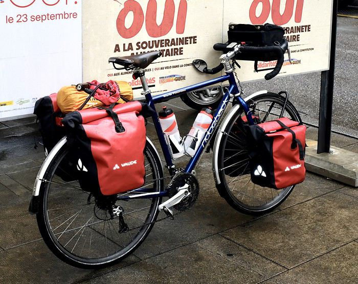
Here’s the beast: a Ridgeback Panorama model, around 10 years old, bought second-hand from a cyclist who’d picked the wrong size. Steel frame in Reynolds 725 (it’s written on it, but I doubt the whole set is that series). Gear ranges from XT for the rear derailleur to some cheaper parts. Three chainrings and sturdy but heavy wheels. Here with 35mm tires—plenty for gravel paths and the occasional rougher trail (as long as you don’t ride like a sausage!).
What I’ve modified: - Upgraded from 9 to 10 speeds when I changed the cassette - Installed two Tubus racks—the rear replaced the original aluminum one (which got bent) - Moved the shifters to the frame instead of the brake/shift combos, which were getting in the way of my handlebar bag - Swapped the saddle for a Brooks B17 (the original one didn’t suit me at all) Over time, some wear-and-tear parts have been replaced.
It’s comfy and sturdy but heavy (almost 14kg). Downsides? It’s a bit sluggish when you stand up to pedal—the chainring rubs against the front derailleur cage (the bottom bracket lacks rigidity). Definitely not a climber’s bike! The cantilever brakes are a tad weak—you get used to them, but you’ve gotta anticipate.
We’ve had some great rides together, but it’ll soon be on the market since I’m replacing it with a custom Cattin. I won’t sell it for much—it’ll make someone happy...
I’ll go first!
Here’s the beast: a Ridgeback Panorama model, around 10 years old, bought second-hand from a cyclist who’d picked the wrong size. Steel frame in Reynolds 725 (it’s written on it, but I doubt the whole set is that series). Gear ranges from XT for the rear derailleur to some cheaper parts. Three chainrings and sturdy but heavy wheels. Here with 35mm tires—plenty for gravel paths and the occasional rougher trail (as long as you don’t ride like a sausage!).
What I’ve modified: - Upgraded from 9 to 10 speeds when I changed the cassette - Installed two Tubus racks—the rear replaced the original aluminum one (which got bent) - Moved the shifters to the frame instead of the brake/shift combos, which were getting in the way of my handlebar bag - Swapped the saddle for a Brooks B17 (the original one didn’t suit me at all) Over time, some wear-and-tear parts have been replaced.
It’s comfy and sturdy but heavy (almost 14kg). Downsides? It’s a bit sluggish when you stand up to pedal—the chainring rubs against the front derailleur cage (the bottom bracket lacks rigidity). Definitely not a climber’s bike! The cantilever brakes are a tad weak—you get used to them, but you’ve gotta anticipate.
We’ve had some great rides together, but it’ll soon be on the market since I’m replacing it with a custom Cattin. I won’t sell it for much—it’ll make someone happy...
It's all in the title—I'm 70, and I've been traveling by bike (tent and camp stove) for five years now. Statistically, how many more years do I have left to plan my destinations and see (almost) everything?
Question is half realistic, half humorous.
To keep it simple: how old are you, fellow senior cyclists still on the road? And what are your biggest challenges?
Personally, I'm in good physical shape, though my cruising speed has dropped from 3–4 km/h over the past five years.
But arthritis (hip) is starting to make it tricky to swing my leg over the frame.
Hi there,
A year ago, I posted looking for a cycling route for a trip in Sicily with my partner and our two kids (3 and 4 years old) in a trailer—something calm, with nature and a bit of culture. I didn’t get many replies, so I’m sharing our itinerary, which we really enjoyed. We cycled from the southeast (Syracuse) to the northwest (Palermo).
**Note:** We had no issues on the road—drivers were very courteous, the welcome was exceptional (lots of invitations to eat and/or stay overnight), and there were very few people on the roads, even the big ones, since we were there from September 23 to October 7.
**Weather:** Apparently, the summer of 2014 had been awful (only 25°C...). We, on the other hand, had 3 days at 44°C—it was *brutal*, including one day at 35°C at 1,000m altitude in the center of the island on October 1st...
**Accommodation:** 15 days of wild camping, with just one really nice apartment after 7 days in Piazza Armerina. Wild camping was tough—rocky, dusty, hard to pitch tent stakes. Our tent got pierced by thorns (even the groundsheet) from one side to the other. We washed up at village fountains, and—let’s be honest—less often than we’d have liked. The kids’ clothes, which spent a lot of time on the ground, were pretty grimy since laundry was rare. Only one official campsite (otherwise, they’re all on the beaches): Da Vinci Camping, in the middle of lemon groves near the southeast (Rosolini). It’s well-known on social media for being very "roots."
**Water:** A real challenge—*very* tough. Off-season, many homes are abandoned, and on some days, we passed through few villages. Result: we always carried our max water (9L) and sometimes had to add extra bottles to last 2 days, covering the day’s ride, wild camping, and the next morning—that’s 15L on the bikes. So be careful with this!
**Itinerary**
We arrived by train in Messina from southern Italy (yes, the train goes onto the ferry—worth seeing!), then took the train to Syracuse. We decided the northeast coast was too dangerous to cycle, so we visited Syracuse and then picked the SP roads (the smallest ones, more or less following the coast) toward Noto. We were supposed to head southeast to Pachino, but since our ferry from Palermo was booked 15 days later, we cut the route short and headed toward Rosolini instead. Nothing exceptional until Modica, crossing the Ispica fault. Modica is a really pretty town to see. Then Ragusa’s old town via the SS 115—a quiet but very scenic road. The town is stunning, but getting through the modern part (Ragusa Alta) means 300–400m of elevation gain... Caltagirone: a lovely town (famous for ceramics), but the center is uphill. We took a bigger road, but there was hardly anyone around. Left via Mirabella, then visited Piazza Armerina and the Villa Romana. Took the SP 15 to Barrafranca, Pietraperzia, then Caltanissetta via the SP96 (choose carefully—there’s a bigger road nearby).
Then Serradifalco, Mussomeli (castle), San Giovanni Gemini—a series of hilltop villages with valleys in between. We climbed and descended 500m+ repeatedly. Santo Stefano Quisquina, Prizzi (passing at 1,000m altitude—really nice, no one around). Corleone (great road, some climbing, but it’s awesome); Ficuzza, Santa Cristina Gela, Altofonte, and Palermo (no traffic issues).
**Reminder:** This was off-season—no one on the roads. We found the route through Caltanissetta, Mussomeli, etc., *spectacular* and sometimes breathtaking. Sicily is a rugged place for rugged people (especially wild camping). We’d heard the center of Sicily was overrated (not at all...). After 4 months of traveling without always listening to others’ opinions, we confirm: central Sicily is amazing—rugged, dramatic, and perfect for what we were looking for (though we didn’t swim).
**Elevation:** People kept saying Sicily was a nightmare for climbing. We’ve done much tougher routes in the Black Forest or Slovenia. The tricky part in central Sicily is the constant ups and downs—you climb 300–600m in one go, then descend right after. We used "Ride with GPS" to test different routes and avoid unnecessary descents (or minimize them). With a few extra kilometers, we saved about 2,000m of elevation gain overall, especially around Caltanissetta, the Modica-Ragusa link, arriving in Modica, and leaving Ragusa.
Hope this helps someone...