Results for "Syrie+souvenir+artisanat"
About 11,262 results.
More options
Many results are in French, the community’s main language. English translations are added over time.
Search results
Instantanés de voyage en Inde (Himachal et Ladakh)
Mercredi 6 juillet
Nous sommes arrivés à Keylong (Himachal Pradesh) sous la neige. Eric n'avait plus de fièvre ce matin, donc plus aucun malade. C'est la première fois depuis longtemps. La pluie a repris la nuit dernière et tombe dru sans discontinuer depuis. Nous sommes partis d'Udaïpur dès que possible, craignant pour l'état de la route. A juste titre. Par rapport à la veille, il y a beaucoup plus de pierres sur la route et l'eau qui dévale rend certains passages très délicats. Certaines portions sont franchies le plus vite possible par Romich qui craint des chutes de pierres. Nous rejoignons enfin la route Manali/Leh et sommes stoppés quelques km plus loin. Une vingtaine de camions sont rangés le long de la route. Il y a eu des éboulements et la route est coupée. Nous patientons une demi-heure, puis 2 jeeps tentent le coup, nous les suivons. Effectivement, les camions ne peuvent pas passer, mais nous si. Rapidement, car Romich est inquiet. 10 km plus loin, nous arrivons à Keylong.
Romich nous conduit à une GH amie. Nous prenons une suite de 2 grandes chambres avec télé et douche chaude ... si l'électricité revient. Nous sommes transis. On nous apporte un grand seau d'eau chaude et du thé. Nous nous réchauffons. Nous sommes à l'abri dans de belles chambres avec une moquette épaisse et propre. Quel luxe pour 800 RPS !
Nous sommes inquiets pour la route à venir. S'il neige ici à 3000 m, la neige doit tenir au dessus de 4000. Renseignements pris, la route est coupée vers Leh, mais aussi dans l'autre sens vers Manali. Il a tellement plu depuis 3 jours que ce n'est pas étonnant. Nous gardons espoir car la route Manali/Leh est stratégique pour l'armée.
18h30
La pluie tombe, rien d'autre à faire que d'attendre. Il est de plus en plus probable que nous ne pourrons partir demain. Excellent déjeuner au restaurant de l'hôtel, le meilleur repas depuis que nous sommes en Inde. L'hôtel s'appelle Snowland (même pas drôle). Après le repas, sieste, lecture et jeu de cartes. Vers 17h, Aurèl, Eric et moi descendons au village acheter des provisions pour les 2 jours de route à venir. Je m'offre un bonnet et des gants de laine tricotés main. C'est chaud, c'est bon. Quand je pense que c'est peut-être la canicule chez nous !
19h30
La nuit tombe, on nous apporte des bougies. L'espoir du retour de l'électricité s'évanouit. La soirée promet d'être longuette, sans lumière et sans musique. Lire à lueur d'une bougie ou d'une lampe torche n'est pas aisé. Il pleut toujours mais le moral reste bon. Nos conditions de vie sont confortables par rapport à celles dans les camps de tentes de Sarchu et Pang à plus de 4000 m.
21h
Il pleut toujours. Nous avons dîné à la chandelle près d'un brasero allumé pour réchauffer les clients. Il y a 2 autres clients que nous avons déjà vus au déjeuner. Ce sont des néerlandais dans la quarantaine qui passent 6 semaines en Inde sur leurs motos Enfield achetées d'occasion à Delhi. Ils sont passés par le Cachemire pour arriver au Ladakh et redescendent par l'Himachal. Comment ont-ils fait pour arriver de Leh dans ces conditions climatiques épouvantables ? Ils sont déjà venus une fois en Inde, en achetant des Enfield qu'ils ont ramenées ensuite jusqu'aux Pays-Bas en 6 semaines. Cette fois, ils vont les revendre à Delhi avant de repartir.
Marc, fatigué, est déjà couché. Soirée lecture pour les autres à la lumière de nos torches à friction achetées à Bangkok, grâce à Thuan. Pas besoin de pile. J'ai mis mon nouveau bonnet et coincé la torche dessous façon frontale, une couverture sur les genoux et les gants, ça vaut une photo. Pourvu que la pluie cesse ...
Nous sommes arrivés à Keylong (Himachal Pradesh) sous la neige. Eric n'avait plus de fièvre ce matin, donc plus aucun malade. C'est la première fois depuis longtemps. La pluie a repris la nuit dernière et tombe dru sans discontinuer depuis. Nous sommes partis d'Udaïpur dès que possible, craignant pour l'état de la route. A juste titre. Par rapport à la veille, il y a beaucoup plus de pierres sur la route et l'eau qui dévale rend certains passages très délicats. Certaines portions sont franchies le plus vite possible par Romich qui craint des chutes de pierres. Nous rejoignons enfin la route Manali/Leh et sommes stoppés quelques km plus loin. Une vingtaine de camions sont rangés le long de la route. Il y a eu des éboulements et la route est coupée. Nous patientons une demi-heure, puis 2 jeeps tentent le coup, nous les suivons. Effectivement, les camions ne peuvent pas passer, mais nous si. Rapidement, car Romich est inquiet. 10 km plus loin, nous arrivons à Keylong.
Romich nous conduit à une GH amie. Nous prenons une suite de 2 grandes chambres avec télé et douche chaude ... si l'électricité revient. Nous sommes transis. On nous apporte un grand seau d'eau chaude et du thé. Nous nous réchauffons. Nous sommes à l'abri dans de belles chambres avec une moquette épaisse et propre. Quel luxe pour 800 RPS !
Nous sommes inquiets pour la route à venir. S'il neige ici à 3000 m, la neige doit tenir au dessus de 4000. Renseignements pris, la route est coupée vers Leh, mais aussi dans l'autre sens vers Manali. Il a tellement plu depuis 3 jours que ce n'est pas étonnant. Nous gardons espoir car la route Manali/Leh est stratégique pour l'armée.
18h30
La pluie tombe, rien d'autre à faire que d'attendre. Il est de plus en plus probable que nous ne pourrons partir demain. Excellent déjeuner au restaurant de l'hôtel, le meilleur repas depuis que nous sommes en Inde. L'hôtel s'appelle Snowland (même pas drôle). Après le repas, sieste, lecture et jeu de cartes. Vers 17h, Aurèl, Eric et moi descendons au village acheter des provisions pour les 2 jours de route à venir. Je m'offre un bonnet et des gants de laine tricotés main. C'est chaud, c'est bon. Quand je pense que c'est peut-être la canicule chez nous !
19h30
La nuit tombe, on nous apporte des bougies. L'espoir du retour de l'électricité s'évanouit. La soirée promet d'être longuette, sans lumière et sans musique. Lire à lueur d'une bougie ou d'une lampe torche n'est pas aisé. Il pleut toujours mais le moral reste bon. Nos conditions de vie sont confortables par rapport à celles dans les camps de tentes de Sarchu et Pang à plus de 4000 m.
21h
Il pleut toujours. Nous avons dîné à la chandelle près d'un brasero allumé pour réchauffer les clients. Il y a 2 autres clients que nous avons déjà vus au déjeuner. Ce sont des néerlandais dans la quarantaine qui passent 6 semaines en Inde sur leurs motos Enfield achetées d'occasion à Delhi. Ils sont passés par le Cachemire pour arriver au Ladakh et redescendent par l'Himachal. Comment ont-ils fait pour arriver de Leh dans ces conditions climatiques épouvantables ? Ils sont déjà venus une fois en Inde, en achetant des Enfield qu'ils ont ramenées ensuite jusqu'aux Pays-Bas en 6 semaines. Cette fois, ils vont les revendre à Delhi avant de repartir.
Marc, fatigué, est déjà couché. Soirée lecture pour les autres à la lumière de nos torches à friction achetées à Bangkok, grâce à Thuan. Pas besoin de pile. J'ai mis mon nouveau bonnet et coincé la torche dessous façon frontale, une couverture sur les genoux et les gants, ça vaut une photo. Pourvu que la pluie cesse ...
Discussion: Bridges of the World July 2026
This is where you can chat about bridges... let’s get the conversation started! 😊
Été 1985 : un voyage de noces hors du commun dans la Chine pop
Deuxième séjour à Pékin en 2018, je discute à l'auberge avec une voyageuse :
"Pékin ! Ici on vit vraiment dans un autre monde."
"Peut-être, mais alors que dire du Pékin des années 80. Une autre planète !"
Ceux qui découvrent cette Chine du 21° siècle ne retrouveront guère que des fragments de celle que je vais raconter ici, comme j'ai pu le constater par moi-même. (Voir mes carnets sur la route de la soie.)
Ce sera donc un carnet "impressions de Chine", ce qui m'est resté de plus marquant. Les quelques photos jaunies que j'ai pu sauver sont scannées et de mauvaise qualité. Merci à Jacqueline et Jean-Pierre pour leur contribution photographique, entièrement d'époque elle aussi.
AU MENU
Préambule - le contexte politique et économique du pays Chapitre 1 - Un voyage qui s'annonce pas très romantique, c'était prévu... Chapitre 2 - Pékin : le trafic de monnaie. Illégal mais indispensable. Chapitre 3 - Pékin 1985-2018 : du Moyen-Age à la révolution technologique. Immersion comparative. Chapitre 4 - Pékin : un billet de train pour Xi'an ? Pas si simple que ça. Chapitre 5 - Le "qi feng shui". Le soigneur se fait soigner. Chapitre 6 - Xi'an : «mei yo», la réponse favorite des fonctionnaires. Chapitre 7 - Vol au-dessus de la jungle. Le coucou arrivera-t-il à bon port ? Chapitre 8 - Chongqing : le bal, ou la vie sexuelle des jeunes chinois. Chapitre 9 - Croisière pop sur le Yangtse. Chapitre 10 - L'hôtel à rats. C'est à Wuhan, comme par hasard. Chapitre 11 - Canton : à la recherche de xiao Wu. Chapitre 12 - Canton : un train sous haute surveillance. Chapitre 13 - Hong Kong : dur retour à la civilisation. Albums : les photos d'époque signées Jacqueline et Jean-Pierre. A partir de la page 5 Témoignages et photos d'époque. Merci aux différents contributeurs. A partir de la page 6. Ne manquez pas le Tibet et le Xinjiang !
PREAMBULE : le contexte politique et économique Comment voyager dans ce pays encore très fermé, obscur, énigmatique, dont en Europe on ne connaît guère la mentalité, les règles de fonctionnement, dont on ne perçoit à l'étranger que quelques images soigneusement filtrées par la censure. Comment se déplacer, se loger, se nourrir, sans moyen de communication, sans réservation d'hôtel ou de train, sans connaître la langue , sans aide, sans guide, sans assistance, sans carte bleue...
1984, date clé pour le voyageur Après trente années de communisme à marche forcée, de campagnes idéologiques calamiteuses pour les populations, de luttes intestines pour le pouvoir, le pays n'arrive pas à décoller économiquement. L'écart grandit avec les nations développées. Mais avec le rétablissement des relations diplomatiques avec les Etats Unis en 1979, le nouveau président, Deng Xiaoping, tient enfin sa revanche et entame sa longue marche vers le progrès. Les fossiles maoïstes de la "longue marche", des "cent fleurs", du "grand bond en avant", les criminels de la "grande révolution culturelle prolétarienne", représentés par la "bande des quatre", tous ceux qui l'avaient évincé du pouvoir et condamné à l'oubli au fin fond d'une province, le sont à leur tour.
Le "révisionniste", comme l'a appelé la veuve Mao, lance ses réformes de libéralisation et d'ouverture de l'économie : « Peu importe qu'un chat soit blanc ou noir, l'essentiel est qu'il attrape les souris ! » Parole du maître.
Parmi ces réformes : l'ouverture au tourisme. Jusqu'à présent, pour visiter le pays, il fallait obligatoirement, soit passer par un tour opérateur avec guide et circuit programmé, soit demander des autorisations de voyage pour un nombre limité de destinations. Très peu pour moi. Mais en 1984, monsieur Deng supprime le permis de circuler et ouvre quasiment tout le pays aux visiteurs. L'info provoque un déclic : - C'est l'occasion ou jamais. L'année prochaine, ce sera la Chine. Et en sac à dos! Et ce sera aussi notre voyage de noces...
Nous aurons le privilège d'être parmi les premiers voyageurs occidentaux à tenter l'aventure. Je pourrai enfin mettre en pratique ce que j'ai appris de chinois à la fac et réaliser un vieux rêve. A nous la Chine, à nous la découverte de ce pays mystérieux et fascinant. Quelle réalité se cache derrière ces images édulcorées de bonheur populaire que nous distillent les images officielles ? Comment vit-on réellement dans ce pays ? Quel accueil réserve-t-on aux impérialistes occidentaux ?

Wuhan, 1985 : slogans révolutionnaires pour mini gardes rouges
CHAPITRE 1 : un voyage qui s'annonce pas très romantique, c'était prévu... Eh oui, juste mariés, il y a peut-être plus glamour comme destination. Bon, Venise, on connaît déjà. Quoi de mieux qu'une telle aventure pour forger un couple ? Pendant toute l'année, je peaufine le projet : itinéraire, transports, hébergements... Les guides de voyage sur la Chine ne sont pas nombreux, il n'en existe d'ailleurs qu'un en français. Pour ce qui est de l'itinéraire, c'est à peu près établi, pour le reste, ce sera au coup par coup, improvisation et opportunités. L'aventure quoi. Juste qu'on dispose d'un mois entre l'atterrissage et le retour à Hong-Kong. Pour l'itinéraire, ce sera donc Pékin - Hong Kong, mais par où et comment ? C'est le grand mystère, même si certains incontournables sont au programme : la Grande Muraille, Xi'an et son armée en terre cuite, la croisière sur le Yang Tse Kiang...
Août 1985 : Hong Kong, premiers pas en extrême-orient Munis d'un joli visa sur notre passeport et d'un billet d'avion Hong Kong - Pékin acheté en agence en France, nous débarquons à Hong Kong pour y passer une nuit avant de repartir pour Pékin le lendemain, L'atterrissage au-dessus de la ville est spectaculaire, l'avion louvoie entre les immeubles pour plonger vers la piste au raz de l'océan, un véritable tour de manège à sensations. Pas trop le temps d'explorer la ville, mais le dépaysement est déjà total. Et pourtant, ce n'est rien à côté de ce qui nous attend...
Ca commence plutôt mal Aéroport de Hong Kong, le lendemain. Nos billets sont valables, pas de problème, seulement : - Désolé, mais vous n'avez pas confirmé votre vol, l'avion est complet. Il va falloir attendre deux ou trois jours... Eh oui, en 1985, il faut confirmer son vol la veille par téléphone. Dans l'excitation et l'émotion, nous avions complètement oublié la consigne. Zut alors, deux ou trois jours de perdus sur le projet, c'est beaucoup trop. - Attendez ici, peut-être il y aura des places si des voyageurs ne se présentent pas. Longue attente plutôt anxieuse, et quelques minutes avant le décollage, petit signe de l'employé : - C'est bon, il reste deux places, vous pouvez partir.
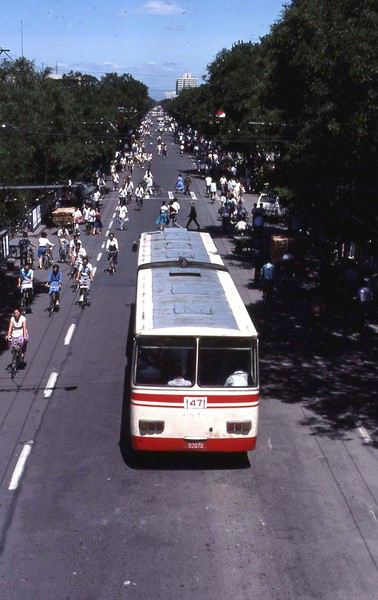
Pékin : avenue Xidan. Photo : Jacqueline et Jean-Pierre
Dès l'aéroport, j'ai senti le choc... Une simple piste en béton, pas d'avion en attente, un trafic aérien quasi nul, un bâtiment à la chinoise, usé et vieillot à souhait, des gardes en uniforme. L'aéroport est encore une base militaire, accessoirement civile pour quelques rares liaisons vers l'URSS et les pays d'Asie. Il n'y a rien dans ce qui fait office de hall d'accueil, une pièce de quelques dizaines de mètres carré tout au plus.
Contrôles minutieux, file d'attente, les militaires ne sont pas très souriants, et le comité d'accueil pas très... accueillant. On n'est pas là pour rigoler, surtout avec ces étrangers qui débarquent de Hong Kong, la zone capitaliste. Eh oui, Hong Kong chinois, ce sera dans une dizaine d'années. D'ici là...
Des billets de Monopoly ?! Un simple bureau dans un recoin fait office de banque. Vite, changer nos travelers chèques en dollars. Ben oui, la carte bleue, ça n'existe pas encore. Derrière son boulier, l'employé fait ses calculs à une vitesse incroyable et me rend le change. Surprise : j'ai une liasse de jolis billets tout neufs dans la main, mais ils n'ont rien à voir avec la monnaie locale. La preuve, il n'y a pas le portrait du grand timonier, mais des jolis dessins de monuments et paysages ! Ca ressemble davantage à des billets de Monopoly.
C'est quoi ce truc ?
Une bonne affaire, mais un gros risque En fait, c'est une monnaie spéciale réservée aux étrangers. Nous allons vite apprendre deux choses. - Un, cette monnaie n'est pas utilisée (et même interdite) par les chinois dans leur vie quotidienne. Elle est réservée aux étrangers et ils doivent payer avec. - Deux, elle est très recherchée par quelques autochtones, car c'est la seule monnaie ayant un équivalent dollar. A l'époque, le yuan chinois ne vaut absolument rien, il n'est pas convertible dans une autre monnaie. Pire que le kopeck. Du coup, notre monnaie "spécial étrangers" fait l'objet d'un trafic formellement interdit et sévèrement réprimé par les autorités.
Mais comment faire si tu veux voyager en dehors des circuits touristiques et des grands hôtels, juste prendre le bus par exemple ou manger dans une gargote. Ca, les autorités n'en ont cure. Un étranger, ça dort dans les hôtels de luxe, ça prend l'avion ou le train en première classe, ça mange dans les grands restaurants. Mieux encore, ça voyage en groupe avec un guide.
Pas d'autre solution, il faudra changer au black Dans la rue, avec les petits trafiquants locaux. Il y a même un cours « officiel » du change : un yuan de Monopoly contre trois yuans de monnaie populaire. A l'époque, un yuan, c'est à peu près un franc. Une sacrée bonne affaire ! Le tout, c'est de ne pas se faire pincer. Les rumeurs les plus folles courent sur les peines encourues pour les trafiquants, mais aussi pour les étrangers qui se font pincer. C'est d'ailleurs marqué sur certains documents. Si les peines de prison ferme ont de quoi dissuader le voyageur, il faudra quand même prendre le risque, pas le choix. Une des nombreuses absurdités du système.
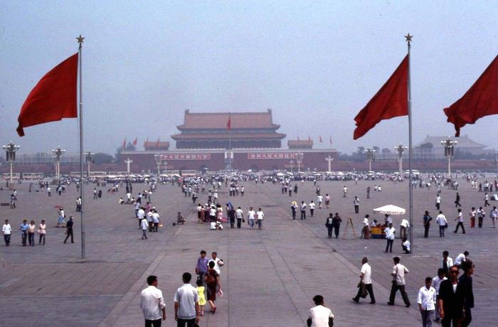
Pékin : place Tian An Men. Photo : Jacqueline et Jean-Pierre
Mise à l'épreuve 1 : trouver un hébergement... Sortie de l'aéroport, c'est l'après-midi. Quelques taxis attendent, réservés aux privilégiés du régime et aux étrangers. Mais nous ne savons même pas où nous allons, juste en ville, et on verra après. Donc ce sera le bus, celui-ci prend la monnaie de Monopoly. C'est notre premier transport en commun, direction le centre ville, à une vingtaine de kilomètres. Très bien, mais où aller, à qui demander un tuyau, un renseignement, une bonne adresse ?
L'aéroport étant en rase campagne, la route bordée d'arbres qui conduit à Pékin centre ressemble à une de nos départementales. De part et d'autres, c'est le défilé des paysans, le plus souvent à pied, tirant des charrettes à bras, quelques fois à bicyclette ou en tracteur. Pour nous occidentaux déjà rodés aux autoroutes, c'est un choc. Ici, pas de voiture individuelle : les véhicules à moteur, c'est juste des camions, quelques bus et de rares taxi, c'est tout .
La carte de Pékin n'indique rien d'autre que le nom des rues, impossible de savoir où se trouve tel service, hôtel, restaurant... Il faut se débrouiller. Les quelques éléments écrits et oraux de chinois que je possède, je vais vite devoir les mettre à l'épreuve. L'anglais ici, on connaît pas.
Juste à côté de nous est assise une jeune femme, bien de sa personne, sans doute un cadre du parti ou d'une grande entreprise. Elle semble plus amène que les autres voyageurs, plus disposée à rendre service. J'entame la conversation comme je peux. Après les échanges d'usage : - Nous sommes français, c'est notre premier voyage en Chine. Connaissez-vous un hôtel sur le trajet du bus qui nous accepterait ? Coup de chance, la femme nous en indique un non loin d'un arrêt, elle nous dira quand il faudra descendre.
Mise à l'épreuve 2 : et qui accepte les étrangers... L'hôtel n'est pas facile à trouver, tout se ressemble ici et rien ne permet de discerner au premier coup d'oeil la fonction d'un bâtiment. Ce n'est même pas écrit « hôtel » à l'entrée. Finalement nous poussons la porte de ce qui semble être ce que nous cherchons. Un étroit couloir sombre, un guichet, une sorte de réception, on dirait un peu un hôtel. Le type de l'accueil est très surpris de nous voir ici, mais oui, c'est bien un hôtel, sauf que : - C'est interdit aux étrangers, vous ne devez pas rester ici ! - Mais comment faire alors ? Le type décroche son téléphone, puis, au bout d'un moment : - Prenez le bus et descendez à cet arrêt, vous y trouverez un hôtel pour vous.
C'est ainsi que nous découvrons que nous ne pourrons pas loger comme on veut dans le pays. La plupart des hôtels sont interdits aux étrangers, il faut toujours aller à l'hôtel spécial « wai guo ren». Oui, mais ce n'est pas forcément indiqué. Quant à dormir chez l'habitant, ce n'est même pas la peine d'y songer, c'est interdit. De plus, quand on voit dans quoi vivent les gens en ville, le peu d'espace dont ils disposent, ça ne donne pas vraiment envie de se faire inviter.
Je ne me souviens plus comment nous avons fait pour trouver le bon bus et le bon arrêt, juste que ça n'a pas été facile du tout. La contrôleuse du bus a tiré une drôle de tronche quand je lui ai tendu le billet de Monoploy, mais elle n'avait pas le choix. Un mao le ticket, dix centimes de franc. Premier aperçu du coup de la vie : trois fois rien. Dans le bus, tous les regards sont fixés sur nous...
Pas de doute, il faut absolument trouver de la monnaie locale, et le plus vite possible. On ne va rien pouvoir faire avec cette monnaie de m... Et quand par hasard ils sont acceptés, on y perd sacrément au change, car ils nous rendent l'argent en monnaie locale. C'est une arnaque gouvernementale bien calculée !
Prochain épisode : le trafic de monnaie
Ce sera donc un carnet "impressions de Chine", ce qui m'est resté de plus marquant. Les quelques photos jaunies que j'ai pu sauver sont scannées et de mauvaise qualité. Merci à Jacqueline et Jean-Pierre pour leur contribution photographique, entièrement d'époque elle aussi.
AU MENU
Préambule - le contexte politique et économique du pays Chapitre 1 - Un voyage qui s'annonce pas très romantique, c'était prévu... Chapitre 2 - Pékin : le trafic de monnaie. Illégal mais indispensable. Chapitre 3 - Pékin 1985-2018 : du Moyen-Age à la révolution technologique. Immersion comparative. Chapitre 4 - Pékin : un billet de train pour Xi'an ? Pas si simple que ça. Chapitre 5 - Le "qi feng shui". Le soigneur se fait soigner. Chapitre 6 - Xi'an : «mei yo», la réponse favorite des fonctionnaires. Chapitre 7 - Vol au-dessus de la jungle. Le coucou arrivera-t-il à bon port ? Chapitre 8 - Chongqing : le bal, ou la vie sexuelle des jeunes chinois. Chapitre 9 - Croisière pop sur le Yangtse. Chapitre 10 - L'hôtel à rats. C'est à Wuhan, comme par hasard. Chapitre 11 - Canton : à la recherche de xiao Wu. Chapitre 12 - Canton : un train sous haute surveillance. Chapitre 13 - Hong Kong : dur retour à la civilisation. Albums : les photos d'époque signées Jacqueline et Jean-Pierre. A partir de la page 5 Témoignages et photos d'époque. Merci aux différents contributeurs. A partir de la page 6. Ne manquez pas le Tibet et le Xinjiang !
PREAMBULE : le contexte politique et économique Comment voyager dans ce pays encore très fermé, obscur, énigmatique, dont en Europe on ne connaît guère la mentalité, les règles de fonctionnement, dont on ne perçoit à l'étranger que quelques images soigneusement filtrées par la censure. Comment se déplacer, se loger, se nourrir, sans moyen de communication, sans réservation d'hôtel ou de train, sans connaître la langue , sans aide, sans guide, sans assistance, sans carte bleue...
1984, date clé pour le voyageur Après trente années de communisme à marche forcée, de campagnes idéologiques calamiteuses pour les populations, de luttes intestines pour le pouvoir, le pays n'arrive pas à décoller économiquement. L'écart grandit avec les nations développées. Mais avec le rétablissement des relations diplomatiques avec les Etats Unis en 1979, le nouveau président, Deng Xiaoping, tient enfin sa revanche et entame sa longue marche vers le progrès. Les fossiles maoïstes de la "longue marche", des "cent fleurs", du "grand bond en avant", les criminels de la "grande révolution culturelle prolétarienne", représentés par la "bande des quatre", tous ceux qui l'avaient évincé du pouvoir et condamné à l'oubli au fin fond d'une province, le sont à leur tour.
Le "révisionniste", comme l'a appelé la veuve Mao, lance ses réformes de libéralisation et d'ouverture de l'économie : « Peu importe qu'un chat soit blanc ou noir, l'essentiel est qu'il attrape les souris ! » Parole du maître.
Parmi ces réformes : l'ouverture au tourisme. Jusqu'à présent, pour visiter le pays, il fallait obligatoirement, soit passer par un tour opérateur avec guide et circuit programmé, soit demander des autorisations de voyage pour un nombre limité de destinations. Très peu pour moi. Mais en 1984, monsieur Deng supprime le permis de circuler et ouvre quasiment tout le pays aux visiteurs. L'info provoque un déclic : - C'est l'occasion ou jamais. L'année prochaine, ce sera la Chine. Et en sac à dos! Et ce sera aussi notre voyage de noces...
Nous aurons le privilège d'être parmi les premiers voyageurs occidentaux à tenter l'aventure. Je pourrai enfin mettre en pratique ce que j'ai appris de chinois à la fac et réaliser un vieux rêve. A nous la Chine, à nous la découverte de ce pays mystérieux et fascinant. Quelle réalité se cache derrière ces images édulcorées de bonheur populaire que nous distillent les images officielles ? Comment vit-on réellement dans ce pays ? Quel accueil réserve-t-on aux impérialistes occidentaux ?
Wuhan, 1985 : slogans révolutionnaires pour mini gardes rouges
CHAPITRE 1 : un voyage qui s'annonce pas très romantique, c'était prévu... Eh oui, juste mariés, il y a peut-être plus glamour comme destination. Bon, Venise, on connaît déjà. Quoi de mieux qu'une telle aventure pour forger un couple ? Pendant toute l'année, je peaufine le projet : itinéraire, transports, hébergements... Les guides de voyage sur la Chine ne sont pas nombreux, il n'en existe d'ailleurs qu'un en français. Pour ce qui est de l'itinéraire, c'est à peu près établi, pour le reste, ce sera au coup par coup, improvisation et opportunités. L'aventure quoi. Juste qu'on dispose d'un mois entre l'atterrissage et le retour à Hong-Kong. Pour l'itinéraire, ce sera donc Pékin - Hong Kong, mais par où et comment ? C'est le grand mystère, même si certains incontournables sont au programme : la Grande Muraille, Xi'an et son armée en terre cuite, la croisière sur le Yang Tse Kiang...
Août 1985 : Hong Kong, premiers pas en extrême-orient Munis d'un joli visa sur notre passeport et d'un billet d'avion Hong Kong - Pékin acheté en agence en France, nous débarquons à Hong Kong pour y passer une nuit avant de repartir pour Pékin le lendemain, L'atterrissage au-dessus de la ville est spectaculaire, l'avion louvoie entre les immeubles pour plonger vers la piste au raz de l'océan, un véritable tour de manège à sensations. Pas trop le temps d'explorer la ville, mais le dépaysement est déjà total. Et pourtant, ce n'est rien à côté de ce qui nous attend...
Ca commence plutôt mal Aéroport de Hong Kong, le lendemain. Nos billets sont valables, pas de problème, seulement : - Désolé, mais vous n'avez pas confirmé votre vol, l'avion est complet. Il va falloir attendre deux ou trois jours... Eh oui, en 1985, il faut confirmer son vol la veille par téléphone. Dans l'excitation et l'émotion, nous avions complètement oublié la consigne. Zut alors, deux ou trois jours de perdus sur le projet, c'est beaucoup trop. - Attendez ici, peut-être il y aura des places si des voyageurs ne se présentent pas. Longue attente plutôt anxieuse, et quelques minutes avant le décollage, petit signe de l'employé : - C'est bon, il reste deux places, vous pouvez partir.
Pékin : avenue Xidan. Photo : Jacqueline et Jean-Pierre
Dès l'aéroport, j'ai senti le choc... Une simple piste en béton, pas d'avion en attente, un trafic aérien quasi nul, un bâtiment à la chinoise, usé et vieillot à souhait, des gardes en uniforme. L'aéroport est encore une base militaire, accessoirement civile pour quelques rares liaisons vers l'URSS et les pays d'Asie. Il n'y a rien dans ce qui fait office de hall d'accueil, une pièce de quelques dizaines de mètres carré tout au plus.
Contrôles minutieux, file d'attente, les militaires ne sont pas très souriants, et le comité d'accueil pas très... accueillant. On n'est pas là pour rigoler, surtout avec ces étrangers qui débarquent de Hong Kong, la zone capitaliste. Eh oui, Hong Kong chinois, ce sera dans une dizaine d'années. D'ici là...
Des billets de Monopoly ?! Un simple bureau dans un recoin fait office de banque. Vite, changer nos travelers chèques en dollars. Ben oui, la carte bleue, ça n'existe pas encore. Derrière son boulier, l'employé fait ses calculs à une vitesse incroyable et me rend le change. Surprise : j'ai une liasse de jolis billets tout neufs dans la main, mais ils n'ont rien à voir avec la monnaie locale. La preuve, il n'y a pas le portrait du grand timonier, mais des jolis dessins de monuments et paysages ! Ca ressemble davantage à des billets de Monopoly.
C'est quoi ce truc ?
Une bonne affaire, mais un gros risque En fait, c'est une monnaie spéciale réservée aux étrangers. Nous allons vite apprendre deux choses. - Un, cette monnaie n'est pas utilisée (et même interdite) par les chinois dans leur vie quotidienne. Elle est réservée aux étrangers et ils doivent payer avec. - Deux, elle est très recherchée par quelques autochtones, car c'est la seule monnaie ayant un équivalent dollar. A l'époque, le yuan chinois ne vaut absolument rien, il n'est pas convertible dans une autre monnaie. Pire que le kopeck. Du coup, notre monnaie "spécial étrangers" fait l'objet d'un trafic formellement interdit et sévèrement réprimé par les autorités.
Mais comment faire si tu veux voyager en dehors des circuits touristiques et des grands hôtels, juste prendre le bus par exemple ou manger dans une gargote. Ca, les autorités n'en ont cure. Un étranger, ça dort dans les hôtels de luxe, ça prend l'avion ou le train en première classe, ça mange dans les grands restaurants. Mieux encore, ça voyage en groupe avec un guide.
Pas d'autre solution, il faudra changer au black Dans la rue, avec les petits trafiquants locaux. Il y a même un cours « officiel » du change : un yuan de Monopoly contre trois yuans de monnaie populaire. A l'époque, un yuan, c'est à peu près un franc. Une sacrée bonne affaire ! Le tout, c'est de ne pas se faire pincer. Les rumeurs les plus folles courent sur les peines encourues pour les trafiquants, mais aussi pour les étrangers qui se font pincer. C'est d'ailleurs marqué sur certains documents. Si les peines de prison ferme ont de quoi dissuader le voyageur, il faudra quand même prendre le risque, pas le choix. Une des nombreuses absurdités du système.
Pékin : place Tian An Men. Photo : Jacqueline et Jean-Pierre
Mise à l'épreuve 1 : trouver un hébergement... Sortie de l'aéroport, c'est l'après-midi. Quelques taxis attendent, réservés aux privilégiés du régime et aux étrangers. Mais nous ne savons même pas où nous allons, juste en ville, et on verra après. Donc ce sera le bus, celui-ci prend la monnaie de Monopoly. C'est notre premier transport en commun, direction le centre ville, à une vingtaine de kilomètres. Très bien, mais où aller, à qui demander un tuyau, un renseignement, une bonne adresse ?
L'aéroport étant en rase campagne, la route bordée d'arbres qui conduit à Pékin centre ressemble à une de nos départementales. De part et d'autres, c'est le défilé des paysans, le plus souvent à pied, tirant des charrettes à bras, quelques fois à bicyclette ou en tracteur. Pour nous occidentaux déjà rodés aux autoroutes, c'est un choc. Ici, pas de voiture individuelle : les véhicules à moteur, c'est juste des camions, quelques bus et de rares taxi, c'est tout .
La carte de Pékin n'indique rien d'autre que le nom des rues, impossible de savoir où se trouve tel service, hôtel, restaurant... Il faut se débrouiller. Les quelques éléments écrits et oraux de chinois que je possède, je vais vite devoir les mettre à l'épreuve. L'anglais ici, on connaît pas.
Juste à côté de nous est assise une jeune femme, bien de sa personne, sans doute un cadre du parti ou d'une grande entreprise. Elle semble plus amène que les autres voyageurs, plus disposée à rendre service. J'entame la conversation comme je peux. Après les échanges d'usage : - Nous sommes français, c'est notre premier voyage en Chine. Connaissez-vous un hôtel sur le trajet du bus qui nous accepterait ? Coup de chance, la femme nous en indique un non loin d'un arrêt, elle nous dira quand il faudra descendre.
Mise à l'épreuve 2 : et qui accepte les étrangers... L'hôtel n'est pas facile à trouver, tout se ressemble ici et rien ne permet de discerner au premier coup d'oeil la fonction d'un bâtiment. Ce n'est même pas écrit « hôtel » à l'entrée. Finalement nous poussons la porte de ce qui semble être ce que nous cherchons. Un étroit couloir sombre, un guichet, une sorte de réception, on dirait un peu un hôtel. Le type de l'accueil est très surpris de nous voir ici, mais oui, c'est bien un hôtel, sauf que : - C'est interdit aux étrangers, vous ne devez pas rester ici ! - Mais comment faire alors ? Le type décroche son téléphone, puis, au bout d'un moment : - Prenez le bus et descendez à cet arrêt, vous y trouverez un hôtel pour vous.
C'est ainsi que nous découvrons que nous ne pourrons pas loger comme on veut dans le pays. La plupart des hôtels sont interdits aux étrangers, il faut toujours aller à l'hôtel spécial « wai guo ren». Oui, mais ce n'est pas forcément indiqué. Quant à dormir chez l'habitant, ce n'est même pas la peine d'y songer, c'est interdit. De plus, quand on voit dans quoi vivent les gens en ville, le peu d'espace dont ils disposent, ça ne donne pas vraiment envie de se faire inviter.
Je ne me souviens plus comment nous avons fait pour trouver le bon bus et le bon arrêt, juste que ça n'a pas été facile du tout. La contrôleuse du bus a tiré une drôle de tronche quand je lui ai tendu le billet de Monoploy, mais elle n'avait pas le choix. Un mao le ticket, dix centimes de franc. Premier aperçu du coup de la vie : trois fois rien. Dans le bus, tous les regards sont fixés sur nous...
Pas de doute, il faut absolument trouver de la monnaie locale, et le plus vite possible. On ne va rien pouvoir faire avec cette monnaie de m... Et quand par hasard ils sont acceptés, on y perd sacrément au change, car ils nous rendent l'argent en monnaie locale. C'est une arnaque gouvernementale bien calculée !
Prochain épisode : le trafic de monnaie
Coup de gueule au sujet de la Turquie
En 1997, lors de mon dernier "road trip" en Turquie, j'ai quitté un peuple attachant, souriant, honnête, libre, toujours prêt à vous aider. J'y suis retourné ce mois d'août après deux semaines à avoir sillonné la Grèce du Nord en famille. J'ai été profondément choqué par le changement que j'ai pu observer et vivre. Lors de mes 5 précédents voyages en 1985, 1989, 1991, 1996 et 1997, à avoir sillonné la Turquie d'est en ouest, et du Nord au Sud, je n'avais jamais vu de femmes vêtues intégralement de noir et intégralement voilées. Après avoir traversé la frontière Gréco-Turque, à la première grande ville traversée, j'ai pu voir de nombreuses femmes intégralement voilées de noir. N'ayant pas prévu de me rendre à Istanbul, je n'avais pas téléchargé la carte de Turquie dans mon GPS. Avec l'absence de panneaux clairs, à environ 2 ou 3 Km de Sultanahmet, j'ai demandé à un groupe de jeunes la direction à suivre pour rejoindre Sultanahmet. " Luetfen, could you please tell me the way to Sultanahmet ?". Il regarde ma plaque d'immatriculation et me répond "Yok" = "non". Cette première expérience d'antipathie a l'égard de nous, perçus comme occidentaux ou mécréants, ou les deux, je pourrais malheureusement la revivre régulièrement durant nos 3 jours passés à Istanbul. Quasiment toutes les femmes Turques d'Istanbul sont désormais voilées, inversement proportionnel à il y a 22ans. Plus moyen de boire une Efes Pilsen ou un vin Turc dans les restaurants où j'ai mangé, il n'y a plus de boissons alcoolisées proposées à la carte !
Je suis profondément triste pour ce peuple qui sombre dans l'obscurantisme de l'Akape et du fondamentalisme islamiste. Ce peuple si attachant, si aimable que j'ai quitté il y a 22 ans est devenu arrogant, fondamentaliste, antipathique. Dommage pour eux ... Il y a 20 fois moins d'occidentaux qu'auparavant à Istanbul ... Je comprends désormais pourquoi ...
Discussion autour du thème du mois de juin 2018: "Murs murs du monde"
Je vous donne rendez-vous ici pour vos photos hors concours, pour discuter, échanger, conseiller, apprendre car... pas de murs entre nous !! 😛
Le concours est ici : voyageforum.com/...post=9045758#9045758
Les précédents concours c'est par là: herikles.free.fr/.VF/VFconcours.html
Le concours est ici : voyageforum.com/...post=9045758#9045758
Les précédents concours c'est par là: herikles.free.fr/.VF/VFconcours.html
Risque de tensions à Barcelone et en Catalogne
Hola 😉
Ne souhaitant pas rentrer dans un débat concernant les développements de la situation politique en Catalogne, débat qui n'a pas sa place dans ce forum, et espérant être clair et concis dans ce qui suit, il me paraît utile d'informer les voyageurs ayant prévu de se rendre dans les prochains jours et prochaines semaines, en Catalogne en général et à Barcelone en particulier, de la situation particulière que vit cette région, et des tensions résultant de la confrontation en cours entre Madrid et les autorités catalanes, tensions qui ne peuvent que s'amplifier dans les heures et jours à venir !!
Difficile de résumer cette situation en quelques mots... Les parlementaires nationalistes-indépendantistes catalans (majoritaires en sièges, mais minoritaires en voix) ont approuvé ces dernières 48 heures, "à la hussarde" (doux euphémisme au vu de la manière dont ont été menés les "débats"), sans information préalable sur les textes qui seraient débattus, sans possibilités pour l'opposition d'amender ces textes, sans tenir compte des avertissements des propres juristes du parlement quant à l'illégalité des procédures employée et des textes proposés, etc..., donc, dans ce contexte, le parlement autonome de la région, a approuvé deux textes. Le premier prévoit l'organisation d'un référendum sur l'indépendance de la Catalogne (prévu le 1er Octobre), et le second organisant dés le 2 Octobre la "déconnection" d'avec Madrid.
Alors que la procédure normale du Parlement de Catalogne, prévoit, comme dans tout parlement au fonctionnement démocratique, un débat contradictoire, puis avant la publication des textes adoptés, leur passage par divers filtres administratifs et juridiques pour en vérifier la légalité et la conformité, dans ce cas précis, ces dispositions conflictuelles ont été adoptées, ratifiées et publiées en 48 heures, au cours de sessions ininterrompues de plus de seize heures, sans laisser aucune possibilité de recours ou d'amendement, que ce soit aux parlementaires d'opposition ou aux juristes du propre parlement? Les débats ont été réduits au strict minimum en flagrante contradiction avec le règlement du Parlement catalan. Les partis opposés aux textes n'ayant eu la faculté que d'une seule et unique intervention, limitée en temps (d'une minute à 15 minutes selon le parti) et sans aucune possibilité d'amendement des textes ou de remise en cause de la procédure appliquée !!!
En dehors des seuls partis nationalistes et indépendantistes catalans, toutes les autres formations politiques, de gauche comme de droite, les corps constitués, le système judiciaire catalan, le système judiciaire espagnol, le gouvernement espagnol et surtout le Conseil Constitutionnel, donc toutes ces entités, chacune dans leur domaine, considèrent les décisions votées en ces circonstances, comme étant illégales et anti-constitutionnelles.
Le choc politique est d'envergure puisque les autorités politiques catalanes qui ont enclenché ce processus, sont en charge de l'autonomie (très large) de la Catalogne, au nom du "peuple espagnol dans son ensemble" et ont juré fidélité à la Constitution espagnole dont aujourd'hui ils disent ne plus reconnaître la légitimité. En "clair" et en résumé, c'est l'éclatement de l'Espagne dans sa forme actuelle qui a été voté !!
Le pouvoir central espagnol, ainsi défié, ne peut ni politiquement, ni légalement rester inactif et d'ores et déjà, moins de 24 heures après ces décisions, le Tribunal Constitutionnel espagnol a déclaré illégaux les textes adoptés par le parlement catalan, et précise que les promoteurs et signataires de ces textes visant à la "déconnection" d'avec Madrid et l'Espagne, seront poursuivis judiciairement, selon les modalités prévues dans la Constitution, pouvant aller jusqu'à la suspension de l'autonomie de la Catalogne et la "mise sous tutelle" de son administration par le pouvoir central, sans préjuger des poursuites et condamnations encourues par les promoteurs et signataires de ces dispositions inconstitutionnelles.
Devant cette menace clairement exprimée, les acteurs de la déconnection ont déclaré qu'ils n'hésiteraient pas à déplacer, "dans la rue", le débat politique en cas de veto madrilène.
Pour situer la dimension de cet imbroglio politico-social, le mouvement nationaliste-indépendantiste représente, au mieux, 50% de la population catalane. Les "autres" 50% se déclarant ouvertement unionistes. La fracture dans la société catalane est nette entre ces deux philosophie politiques, et cette donnée aura son importance dans les jours et semaines à venir.
Illustration de cette situation exceptionnellement compliquée : le Govern catalan dispose d'une force de police "autonome", placée sous son autorité, ce sont "Los Mossos D'squadra". A l'heure d'un éventuel référendum, c'est ce corps de police qui sera chargé, à la demande du Govern catalan, de la sécurité publique et du maintien de l'ordre pour en assurer le bon déroulement. Mais dans le même temps, ce même corps de police autonome fait partie intégrante des forces de sécurité nationale, dépendant directement du Ministère de l'intérieur espagnol, au même titre que la Guardia Civil ou la Policia Nacional. Tous les policiers catalans servant dans le corps des Mossos ont juré fidélité à la Constitution espagnole et obéissance aux autorités chargées de la faire respecter. Même si leur autorité de tutelle directe est le Govern catalan, qui vient par ailleurs de placer à leur tête, en tant que "Conseiller à l'Intérieur", un nationaliste-indépendantiste des plus intégristes, in fine ils sont placés sous l'autorité du Ministère de l'Intérieur espagnol (qui assure, entre autres, leurs salaires)
Il est facile d'imaginer le dilemme qui se posera à ces fonctionnaires de police, qui recevront, le même jour, l'ordre, de la part du Ministère de l'intérieur de Madrid, de prendre toutes les mesures pour empêcher le déroulement du référendum (retrait des urnes, saisies des listes et bulletins, fermetures des bureaux de vote), et dans le même temps, un autre ordre, émanant du Govern catalan, afin qu'ils prennent les dispositions pour que le référendum puisse se dérouler dans la "normalité", en assurant la sécurité des bureaux de vote, des scrutateurs et des électeurs !!
Enfin il est remarquable de constater la présence "côte à côte", dans ce mouvement nationaliste-indépendantiste, de partis politiques que tout oppose par ailleurs, comme JxSI (Juntos por si) regroupement de conservateurs libéraux et du parti ERC, parti de gauche anti-libéral et républicain (dans l'acception espagnole) et, de plus, à ce "joint-venture" et afin d'obtenir la majorité parlementaire, est venue s'ajouter la CUP, parti anti-système et anti-capitaliste de l'ultra gauche. C'est l'alliance de l'eau et du feu sous la banière sécessionniste.
Pour compléter le tableau, le 11 Septembre, comme tous les ans, sera célébrée, en Catalogne, la DIADA, qui est la "fête nationale" de cette région. Traditionnellement, l'acte le plus important de cette journée se déroule à Barcelone et rassemble plusieurs centaines de milliers de personnes. A l'origine, la DIADA est un acte commémoratif et festif, mais depuis quelques années il est clairement devenu une manifestation revendicative, une démonstration politique nationaliste et ouvertement anti-espagnole. Mais cette manifestation est toujours restée pacifique et festive. Par contre, dans trois jours se déroulera la Diada 2017 dans ce climat de confrontation entre nationaliste catalans et catalans unionistes, alors que les premières mesures "anti-référendum" auront été prises et pour certaines appliquées !!!
Après la manifestation de condamnation des attentats de Barcelone, le 27 Août, manifestation qui a été détournée de son objet par les nationalistes radicaux qui en ont fait un acte revendicatif anti-espagnol, et devant la réaction du gouvernement central dont les premières mesures visent à empêcher le déroulement de ce référendum du 1er Octobre, déclaré illégal, on peut espérer que les "pros" et les "antis" ne se retrouvent face à face dans la rue à l'occasion de la DIADA du 11 Septembre... Bien malin celui ou celle qui peut prévoir ce qui pourrait se passer !!!
D'ores et déjà, les injonctions contradictoires arrivent aux autorités administratives et judiciaires en ce qui concerne l'organisation de cet hypothétique référendum du 1er Octobre. Le Govern catalan ordonnant la mise à disposition des moyens nécessaires pour cette consultation (bureaux de vote, scrutateurs, listes électorales...) les autorités espagnoles et la justice (catalane et espagnole) avisant ces mêmes personnes qu'elles commettraient un délit en fournissant ces moyens pour l'organisation d'une consultation illégale !!!
L'information sur le sujet m'ayant paru très "discrète" et pour le moins "parcellaire" hors d'Espagne, il m'a paru intéressant de donner (modestement) à d'éventuels voyageurs vers la Catalogne et Barcelone, ce résumé de l'actualité politique dans la région, en espérant qu'il pourra, le cas échéant, leur permettre de mieux comprendre des situations ou évènements auxquels ils pourraient assister durant leur séjour.
Hasta luego 😎
Ne souhaitant pas rentrer dans un débat concernant les développements de la situation politique en Catalogne, débat qui n'a pas sa place dans ce forum, et espérant être clair et concis dans ce qui suit, il me paraît utile d'informer les voyageurs ayant prévu de se rendre dans les prochains jours et prochaines semaines, en Catalogne en général et à Barcelone en particulier, de la situation particulière que vit cette région, et des tensions résultant de la confrontation en cours entre Madrid et les autorités catalanes, tensions qui ne peuvent que s'amplifier dans les heures et jours à venir !!
Difficile de résumer cette situation en quelques mots... Les parlementaires nationalistes-indépendantistes catalans (majoritaires en sièges, mais minoritaires en voix) ont approuvé ces dernières 48 heures, "à la hussarde" (doux euphémisme au vu de la manière dont ont été menés les "débats"), sans information préalable sur les textes qui seraient débattus, sans possibilités pour l'opposition d'amender ces textes, sans tenir compte des avertissements des propres juristes du parlement quant à l'illégalité des procédures employée et des textes proposés, etc..., donc, dans ce contexte, le parlement autonome de la région, a approuvé deux textes. Le premier prévoit l'organisation d'un référendum sur l'indépendance de la Catalogne (prévu le 1er Octobre), et le second organisant dés le 2 Octobre la "déconnection" d'avec Madrid.
Alors que la procédure normale du Parlement de Catalogne, prévoit, comme dans tout parlement au fonctionnement démocratique, un débat contradictoire, puis avant la publication des textes adoptés, leur passage par divers filtres administratifs et juridiques pour en vérifier la légalité et la conformité, dans ce cas précis, ces dispositions conflictuelles ont été adoptées, ratifiées et publiées en 48 heures, au cours de sessions ininterrompues de plus de seize heures, sans laisser aucune possibilité de recours ou d'amendement, que ce soit aux parlementaires d'opposition ou aux juristes du propre parlement? Les débats ont été réduits au strict minimum en flagrante contradiction avec le règlement du Parlement catalan. Les partis opposés aux textes n'ayant eu la faculté que d'une seule et unique intervention, limitée en temps (d'une minute à 15 minutes selon le parti) et sans aucune possibilité d'amendement des textes ou de remise en cause de la procédure appliquée !!!
En dehors des seuls partis nationalistes et indépendantistes catalans, toutes les autres formations politiques, de gauche comme de droite, les corps constitués, le système judiciaire catalan, le système judiciaire espagnol, le gouvernement espagnol et surtout le Conseil Constitutionnel, donc toutes ces entités, chacune dans leur domaine, considèrent les décisions votées en ces circonstances, comme étant illégales et anti-constitutionnelles.
Le choc politique est d'envergure puisque les autorités politiques catalanes qui ont enclenché ce processus, sont en charge de l'autonomie (très large) de la Catalogne, au nom du "peuple espagnol dans son ensemble" et ont juré fidélité à la Constitution espagnole dont aujourd'hui ils disent ne plus reconnaître la légitimité. En "clair" et en résumé, c'est l'éclatement de l'Espagne dans sa forme actuelle qui a été voté !!
Le pouvoir central espagnol, ainsi défié, ne peut ni politiquement, ni légalement rester inactif et d'ores et déjà, moins de 24 heures après ces décisions, le Tribunal Constitutionnel espagnol a déclaré illégaux les textes adoptés par le parlement catalan, et précise que les promoteurs et signataires de ces textes visant à la "déconnection" d'avec Madrid et l'Espagne, seront poursuivis judiciairement, selon les modalités prévues dans la Constitution, pouvant aller jusqu'à la suspension de l'autonomie de la Catalogne et la "mise sous tutelle" de son administration par le pouvoir central, sans préjuger des poursuites et condamnations encourues par les promoteurs et signataires de ces dispositions inconstitutionnelles.
Devant cette menace clairement exprimée, les acteurs de la déconnection ont déclaré qu'ils n'hésiteraient pas à déplacer, "dans la rue", le débat politique en cas de veto madrilène.
Pour situer la dimension de cet imbroglio politico-social, le mouvement nationaliste-indépendantiste représente, au mieux, 50% de la population catalane. Les "autres" 50% se déclarant ouvertement unionistes. La fracture dans la société catalane est nette entre ces deux philosophie politiques, et cette donnée aura son importance dans les jours et semaines à venir.
Illustration de cette situation exceptionnellement compliquée : le Govern catalan dispose d'une force de police "autonome", placée sous son autorité, ce sont "Los Mossos D'squadra". A l'heure d'un éventuel référendum, c'est ce corps de police qui sera chargé, à la demande du Govern catalan, de la sécurité publique et du maintien de l'ordre pour en assurer le bon déroulement. Mais dans le même temps, ce même corps de police autonome fait partie intégrante des forces de sécurité nationale, dépendant directement du Ministère de l'intérieur espagnol, au même titre que la Guardia Civil ou la Policia Nacional. Tous les policiers catalans servant dans le corps des Mossos ont juré fidélité à la Constitution espagnole et obéissance aux autorités chargées de la faire respecter. Même si leur autorité de tutelle directe est le Govern catalan, qui vient par ailleurs de placer à leur tête, en tant que "Conseiller à l'Intérieur", un nationaliste-indépendantiste des plus intégristes, in fine ils sont placés sous l'autorité du Ministère de l'Intérieur espagnol (qui assure, entre autres, leurs salaires)
Il est facile d'imaginer le dilemme qui se posera à ces fonctionnaires de police, qui recevront, le même jour, l'ordre, de la part du Ministère de l'intérieur de Madrid, de prendre toutes les mesures pour empêcher le déroulement du référendum (retrait des urnes, saisies des listes et bulletins, fermetures des bureaux de vote), et dans le même temps, un autre ordre, émanant du Govern catalan, afin qu'ils prennent les dispositions pour que le référendum puisse se dérouler dans la "normalité", en assurant la sécurité des bureaux de vote, des scrutateurs et des électeurs !!
Enfin il est remarquable de constater la présence "côte à côte", dans ce mouvement nationaliste-indépendantiste, de partis politiques que tout oppose par ailleurs, comme JxSI (Juntos por si) regroupement de conservateurs libéraux et du parti ERC, parti de gauche anti-libéral et républicain (dans l'acception espagnole) et, de plus, à ce "joint-venture" et afin d'obtenir la majorité parlementaire, est venue s'ajouter la CUP, parti anti-système et anti-capitaliste de l'ultra gauche. C'est l'alliance de l'eau et du feu sous la banière sécessionniste.
Pour compléter le tableau, le 11 Septembre, comme tous les ans, sera célébrée, en Catalogne, la DIADA, qui est la "fête nationale" de cette région. Traditionnellement, l'acte le plus important de cette journée se déroule à Barcelone et rassemble plusieurs centaines de milliers de personnes. A l'origine, la DIADA est un acte commémoratif et festif, mais depuis quelques années il est clairement devenu une manifestation revendicative, une démonstration politique nationaliste et ouvertement anti-espagnole. Mais cette manifestation est toujours restée pacifique et festive. Par contre, dans trois jours se déroulera la Diada 2017 dans ce climat de confrontation entre nationaliste catalans et catalans unionistes, alors que les premières mesures "anti-référendum" auront été prises et pour certaines appliquées !!!
Après la manifestation de condamnation des attentats de Barcelone, le 27 Août, manifestation qui a été détournée de son objet par les nationalistes radicaux qui en ont fait un acte revendicatif anti-espagnol, et devant la réaction du gouvernement central dont les premières mesures visent à empêcher le déroulement de ce référendum du 1er Octobre, déclaré illégal, on peut espérer que les "pros" et les "antis" ne se retrouvent face à face dans la rue à l'occasion de la DIADA du 11 Septembre... Bien malin celui ou celle qui peut prévoir ce qui pourrait se passer !!!
D'ores et déjà, les injonctions contradictoires arrivent aux autorités administratives et judiciaires en ce qui concerne l'organisation de cet hypothétique référendum du 1er Octobre. Le Govern catalan ordonnant la mise à disposition des moyens nécessaires pour cette consultation (bureaux de vote, scrutateurs, listes électorales...) les autorités espagnoles et la justice (catalane et espagnole) avisant ces mêmes personnes qu'elles commettraient un délit en fournissant ces moyens pour l'organisation d'une consultation illégale !!!
L'information sur le sujet m'ayant paru très "discrète" et pour le moins "parcellaire" hors d'Espagne, il m'a paru intéressant de donner (modestement) à d'éventuels voyageurs vers la Catalogne et Barcelone, ce résumé de l'actualité politique dans la région, en espérant qu'il pourra, le cas échéant, leur permettre de mieux comprendre des situations ou évènements auxquels ils pourraient assister durant leur séjour.
Hasta luego 😎
Que choisir à Madagascar
Bonjour à tous,
Je risque de partir à Madagascar vers le 15 octobre. Et, c'est un peu de la "dernière minute". Je ne suis donc pas préparée. J'ai l'habitude de voyager seule depuis dix ans mais surtout (voire exclusivement) en Asie.
J'aurais besoin de vos conseils :-) Tout d'abord, parce qu'on me parle beaucoup d'insécurité (même en dehors de Tana... Et j(avoue que le Bresil m'a laissé un petit goût amer par rapport à ça...)
Et surtout parce que Madagascar c'est une grande île et que je vais devoir choisir/ Je ne reste que 25 jours ( ce qui est déjà pas mal :-), mais je ne veux pas courir dans tous les sens.
Que me conseillez-vous ? Le nord ? L'Ouest ? L'est ?
J'aimerais voir vivre Madagascar, de l'interieur, marcher un peu dans de la nature et me poser quelques jours sur une jolie plage...
Si vous avez des idées, des avis, des conseils, des coups de cœur, des Guest house super... Bref. MERCI BEAUCOUP d'avance :-)
Sophie
Je risque de partir à Madagascar vers le 15 octobre. Et, c'est un peu de la "dernière minute". Je ne suis donc pas préparée. J'ai l'habitude de voyager seule depuis dix ans mais surtout (voire exclusivement) en Asie.
J'aurais besoin de vos conseils :-) Tout d'abord, parce qu'on me parle beaucoup d'insécurité (même en dehors de Tana... Et j(avoue que le Bresil m'a laissé un petit goût amer par rapport à ça...)
Et surtout parce que Madagascar c'est une grande île et que je vais devoir choisir/ Je ne reste que 25 jours ( ce qui est déjà pas mal :-), mais je ne veux pas courir dans tous les sens.
Que me conseillez-vous ? Le nord ? L'Ouest ? L'est ?
J'aimerais voir vivre Madagascar, de l'interieur, marcher un peu dans de la nature et me poser quelques jours sur une jolie plage...
Si vous avez des idées, des avis, des conseils, des coups de cœur, des Guest house super... Bref. MERCI BEAUCOUP d'avance :-)
Sophie
Inde... ou comment le pire cauchemar des hippies est en train de se réaliser
Depuis décembre 2006, j'ai passé plus d'une année en Inde. Mon dernier séjour (avant celui-ci) remonte à décembre 2010. Que de changements depuis ! Je ne me retrouve plus dans ce pays où les nouveaux riches dédaignent les plus pauvres et où les routards, bien propres sur eux, ont supplanté les hippies des seventies. Je viens de publier sur mon blog un long texte où je développe ces réflexions. J'aimerais le partager, ici, avec vous :
Mutation des rapports humains dans une Inde en plein essor économique ou comment le pire cauchemar des hippies est en train se réaliser.
D’ici 2020, la production économique combinée de trois grands pays en développement (le Brésil, la Chine et l’Inde) dépassera à elle seule la production cumulée du Canada, de la France, de l’Allemagne, de l’Italie, du Royaume-Uni et des États-Unis." Rapport 2013 du Programme des Nations Unies pour le Développement.
Fin 2013, l'Inde est bien différente de celle que j'ai connu fin 2006. Au total, au gré de mes voyages, j'ai passé plus d'une année dans ce pays où les fêtes religieuses dédiées à Brahma, Vishnu, Shiva ou encore Ganesh rythment la vie de 1,2 milliard d'êtres humains. Fin 2013, les écarts se sont encore creusés : les riches sont plus riches tandis que les pauvres sont plus pauvres. Ca paraît très con écrit comme cela mais pourtant cela change la face du pays... et ma relation avec l'Inde.
La roupie s'est effondrée depuis mon dernier séjour : dorénavant, un euro se change à plus de 80 roupies contre 50 en 2011. Mes amis gagnent toujours entre 1500 et 3000 roupies mensuels (pour 12h de travail par jour et ce, 7 jours sur 7). Je vous laisse faire le calcul... Dans les hôtels où je pose mon sac, la majorité des touristes sont des indiens. Tous les professionnels du secteur que je rencontre me font remarquer que la crise européenne ne semble plus permettre à nos concitoyens de s'envoler vers le pays des rajas à défaut comme nos aînés de tracer leur route à travers l'Afghanistan et le Pakistan, et que les mots « vacances » et « tourisme » sont désormais ancrés dans le vocabulaire d'une nouvelle élite indienne qui avant 2020, représentera plus de monde que dans n'importe quel pays européen. Tous s'accordent pour me dire leur surprise : les touristes indiens (plus exigeants – lire leurs commentaires sur Trip Advisor) paient mieux que les occidentaux ! Depuis deux mois que je suis en Inde, je me sens plutôt désargentée avec mon budget de 20 euros par jour, à côté de ces touristes, de tous âges, originaires de Bangalore, Calcutta, Delhi, Pune ou Mumbai, qui raffolent des marques européennes, japonaises et nord-américaines : Apple, Nikon, Canon, Nike, Lacoste, Tommy Hilfiger, Calvin Klein, Armani, Pepe Jeans etc et qui se gargarisent de participer à des Big Fat Indian Weddings.
Impossible d'ignorer ces nombreux indiens, de plus en plus visibles, qui nous imaginent tous nymphomanes et libertins, qui jalousent notre liberté de mouvement, nos origines européennes et ne peuvent s'empêcher de vérifier qu'ils ont bien (au moins) le même pouvoir d'achat que nous. Sans cesse, ils nous demandent la valeur de nos possessions. Et ton jean ? Il coûte combien ton jean ? Et ton appareil photo ? Il coûte combien ton appareil photo ? Certains se décrivent plus éduqués que leurs compatriotes « qui ressemblent à des singes » et nous citent les philosophes des Lumières. Sur les rooftops des hôtels, des clans se forment. D'un côté, les occidentaux lisent leur fil d'actualité Facebook sur leur smartphone et de l'autre, les indiens... lisent leur fil d'actualité Facebook sur leur smartphone. Les occidentaux semblent nostalgiques de ce temps de l'entre-soi mais se sentent encore valorisés par le traitement privilégié qu'ils reçoivent : ici, la police touristique donne systématiquement raison aux occidentaux, et ce même s'ils sont de mauvaise foi : plus d'un indien a fini en garde à vue à se faire tabasser parce qu'il aurait importuner des « voyageurs ». Quant aux touristes indiens, certains se sentent incommodés par la proximité physique avec nos jeunes femmes dénudées qui fument et boivent de l'alcool devant leur épouse tandis que d'autres, nous apostrophent pour nous photographier : avoir un ami occidental leur confère une stature internationale.
En ce moment même, je vous écris de la terrasse de mon hôtel où des couples français sympathisent et se relatent leurs déboires avec les conducteurs de rickshaws, le personnel des hôtels et tous ces indiens qui les assimilent à des portefeuilles sur pattes. Ils échangent leurs bonnes adresses puisées dans le Guide du Routard et le Lonely Planet. Ils se demandent quel médicament contre le paludisme ils avalent. Ils détaillent les avantages de leur veste en gore-tex et de leur pantalon Quechua. Ils comparent l'authenticité des locaux dans chaque pays traversé (comprendre ceux qui ne sont pas encore pollués par le monde moderne comme si en 2013, même dans les villages reculés la télévision par câble n'était pas entrée dans les foyers des plus pauvres). Ils énumèrent ce qu'ils ont fait/ce qu'ils font : la Chine en un mois pour certains, le tour du monde en un an pour les autres. Ils comptent les jours de pluie qu'ils ont eu sans évoquer le cyclone qui a déplacé un demi million d'indiens et détruit des milliers d'habitations, la semaine dernière. Ils reviennent de Rishikeshoù ils ont pratiqué le yoga « pour ouvrir leurs chakras » et ont appris la méditation transcendantale dans un ashram tenu par un gourou qui leur a ouvert les yeux sur leur nature profonde et leur rôle dans l'Univers. Ils disent qu'ils ont démissionné de leur job « pour découvrir le monde » tout en se gaussant, dans la langue de Molière, du style vestimentaire du serveur qui leur apporte, avec un timide sourire d'adolescent mal dégrossi, leur brochette de poulet tandoori.
Entre ces nouveaux riches indiens pour qui la classe sociale tend à abolir les castes mais qui dédaignent les plus pauvres et ces touristes occidentaux en pleine quête existentielle qui se posent en lutte contre une uniformisation du monde mais qui ne prennent pas le temps de dialoguer avec des locaux préférant cumuler les lieux visités en photographiant au zoom le moindre sadhu comme témoignage de leur exotique passage dans cet « Incredible India », gimmick martelé par le Ministère du tourisme indien dans des spots publicitaires qui tournent en boucle sur CNN, je ne me retrouve plus.
Je pourrais fuir ces lieux nommés dans les guides touristiques et aller à la rencontre des fermiers du Bihar ou de l'Andrah Pradesh mais l'envie a disparu. Je me réjouis de l'explosion de cette classe moyenne-supérieure indienne tout en me lamentant de son ridicule mimétisme : les filles s'arrachent les crèmes qui blanchissent la peau tandis que les garçons se prennent pour des rappeurs américains ou des lords anglais. Bien sûr, une classe d'intellectuels et d'artistes tentent de braver ce tsunami. Bien sûr, il reste de l'indianité en ces nouveaux riches mais pour combien d'années encore ? En 2009, Pavan K. Varma a publié « un virulent réquisitoire contre cette classe moyenne qu'il exhorte à un réveil civique, dans la haute tradition des pères fondateurs de l'Inde dont il se refuse à voir l'héritage renié » (extrait de la quatrième de couv' de La classe moyenne en Inde, une nouvelle caste).C'est tellement ça.... Une telle frénésie consumériste... Des nouveaux riches indiens qui font preuve d'un tel désintérêt à l'égard de la chose publique et du bien commun...
Voyager seule pendant dix années m'a fait connaître des personnes et des situations qui m'ont ouvert l'esprit au delà de ce que ma culture française me permettait. Cette décennie a affirmé ma confiance en moi, m'a permis de définir mes priorités dans la vie et m'a appris à jouir du présent. Seulement, dorénavant, je ne suis plus assoiffée par cette curiosité qui m'a fait traverser la Syrie, l'Afrique, l'Inde, l'Asie du Sud-Est et le Venezuela de Hugo Chavez. L'exotisme ne me fait plus rêver : derrière chaque carte postale, se cache de la laideur. Cette laideur, je ne désire plus la côtoyer. La misère- qui-n'est-pas-moins-pénible-au-soleil me désole de plus en plus : je peine à m'émerveiller du sourire ravi d'un enfant en haillons, la morve au nez et les cheveux pouilleux. Dans un même temps, que les indiens et les asiatiques s'enrichissent mais je ne veux plus être le témoin direct de ce passage de l'ère du kitsch à celle du bling bling (selon mes codes socio-culturels, soit...). Que les routards continuent de fantasmer un monde qui n'existe plus que dans les récits des écrivains-voyageurs des XIX° et XX° siècles mais qu'ils ne me vantent plus leurs soi-disantes extrêmes expériences aux confins du trou du cul du monde. Chacun vit son expérience en voyage. Chacun ressent de fortes émotions. Chacun gère comme il peut le flot de mendiants. Chacun met son corps à l'épreuve dans des pays tropicaux. Chacun croit être un voyageur plus responsable que ses congénères... mais qu'on soit bien clair, l'habit ne fait pas le moine : des dreadlocks et une chemise en coton équitable ne rendent pas plus respectueux des populations et des coutumes locales. Reste la nature quand l'industrie agroalimentaire ne la détruit pas. Reste les fonds sous-marins quand le réchauffement climatique (ou la pêche à la bombe) ne tue pas les récifs coralliens. Reste des lieux que je chéris. Des personnes que je considère comme des amis sur les cinq continents. Des rayons de soleil qui aident à traverser nos longs hivers français. Des souvenirs et un sentiment d'accomplissement d'être allée au bout des mes rêves d'adolescente.
Pendant que je me larmoie sur cette mutation des rapports humains dans une Inde en plein essor économique, mes amis indiens assistent, impuissants, à cette historique révolution sociale. Ils cumulent les emplois. Ils dorment 4 à 5 heures par nuit. Parfois sur leur lieu de travail abandonnant, contre leur volonté, le lit conjugal pendant des années. Ils bataillent au quotidien, sans savoir de quoi sera fait leur lendemain, pour trouver les quelques roupies qui leur permettent de nourrir leur famille, payer les fournitures scolaires de leurs enfants et les traitements médicaux de leurs parents. Alors oui, ils se prennent des commissions sur le dos des touristes (indiens et occidentaux confondus) mais qui peut vivre décemment avec 30 euros par mois dans un pays où le litre d'essence avoisine 1 euro le litre ?
Le texte original (avec photos) ICI.
Mutation des rapports humains dans une Inde en plein essor économique ou comment le pire cauchemar des hippies est en train se réaliser.
D’ici 2020, la production économique combinée de trois grands pays en développement (le Brésil, la Chine et l’Inde) dépassera à elle seule la production cumulée du Canada, de la France, de l’Allemagne, de l’Italie, du Royaume-Uni et des États-Unis." Rapport 2013 du Programme des Nations Unies pour le Développement.
Fin 2013, l'Inde est bien différente de celle que j'ai connu fin 2006. Au total, au gré de mes voyages, j'ai passé plus d'une année dans ce pays où les fêtes religieuses dédiées à Brahma, Vishnu, Shiva ou encore Ganesh rythment la vie de 1,2 milliard d'êtres humains. Fin 2013, les écarts se sont encore creusés : les riches sont plus riches tandis que les pauvres sont plus pauvres. Ca paraît très con écrit comme cela mais pourtant cela change la face du pays... et ma relation avec l'Inde.
La roupie s'est effondrée depuis mon dernier séjour : dorénavant, un euro se change à plus de 80 roupies contre 50 en 2011. Mes amis gagnent toujours entre 1500 et 3000 roupies mensuels (pour 12h de travail par jour et ce, 7 jours sur 7). Je vous laisse faire le calcul... Dans les hôtels où je pose mon sac, la majorité des touristes sont des indiens. Tous les professionnels du secteur que je rencontre me font remarquer que la crise européenne ne semble plus permettre à nos concitoyens de s'envoler vers le pays des rajas à défaut comme nos aînés de tracer leur route à travers l'Afghanistan et le Pakistan, et que les mots « vacances » et « tourisme » sont désormais ancrés dans le vocabulaire d'une nouvelle élite indienne qui avant 2020, représentera plus de monde que dans n'importe quel pays européen. Tous s'accordent pour me dire leur surprise : les touristes indiens (plus exigeants – lire leurs commentaires sur Trip Advisor) paient mieux que les occidentaux ! Depuis deux mois que je suis en Inde, je me sens plutôt désargentée avec mon budget de 20 euros par jour, à côté de ces touristes, de tous âges, originaires de Bangalore, Calcutta, Delhi, Pune ou Mumbai, qui raffolent des marques européennes, japonaises et nord-américaines : Apple, Nikon, Canon, Nike, Lacoste, Tommy Hilfiger, Calvin Klein, Armani, Pepe Jeans etc et qui se gargarisent de participer à des Big Fat Indian Weddings.
Impossible d'ignorer ces nombreux indiens, de plus en plus visibles, qui nous imaginent tous nymphomanes et libertins, qui jalousent notre liberté de mouvement, nos origines européennes et ne peuvent s'empêcher de vérifier qu'ils ont bien (au moins) le même pouvoir d'achat que nous. Sans cesse, ils nous demandent la valeur de nos possessions. Et ton jean ? Il coûte combien ton jean ? Et ton appareil photo ? Il coûte combien ton appareil photo ? Certains se décrivent plus éduqués que leurs compatriotes « qui ressemblent à des singes » et nous citent les philosophes des Lumières. Sur les rooftops des hôtels, des clans se forment. D'un côté, les occidentaux lisent leur fil d'actualité Facebook sur leur smartphone et de l'autre, les indiens... lisent leur fil d'actualité Facebook sur leur smartphone. Les occidentaux semblent nostalgiques de ce temps de l'entre-soi mais se sentent encore valorisés par le traitement privilégié qu'ils reçoivent : ici, la police touristique donne systématiquement raison aux occidentaux, et ce même s'ils sont de mauvaise foi : plus d'un indien a fini en garde à vue à se faire tabasser parce qu'il aurait importuner des « voyageurs ». Quant aux touristes indiens, certains se sentent incommodés par la proximité physique avec nos jeunes femmes dénudées qui fument et boivent de l'alcool devant leur épouse tandis que d'autres, nous apostrophent pour nous photographier : avoir un ami occidental leur confère une stature internationale.
En ce moment même, je vous écris de la terrasse de mon hôtel où des couples français sympathisent et se relatent leurs déboires avec les conducteurs de rickshaws, le personnel des hôtels et tous ces indiens qui les assimilent à des portefeuilles sur pattes. Ils échangent leurs bonnes adresses puisées dans le Guide du Routard et le Lonely Planet. Ils se demandent quel médicament contre le paludisme ils avalent. Ils détaillent les avantages de leur veste en gore-tex et de leur pantalon Quechua. Ils comparent l'authenticité des locaux dans chaque pays traversé (comprendre ceux qui ne sont pas encore pollués par le monde moderne comme si en 2013, même dans les villages reculés la télévision par câble n'était pas entrée dans les foyers des plus pauvres). Ils énumèrent ce qu'ils ont fait/ce qu'ils font : la Chine en un mois pour certains, le tour du monde en un an pour les autres. Ils comptent les jours de pluie qu'ils ont eu sans évoquer le cyclone qui a déplacé un demi million d'indiens et détruit des milliers d'habitations, la semaine dernière. Ils reviennent de Rishikeshoù ils ont pratiqué le yoga « pour ouvrir leurs chakras » et ont appris la méditation transcendantale dans un ashram tenu par un gourou qui leur a ouvert les yeux sur leur nature profonde et leur rôle dans l'Univers. Ils disent qu'ils ont démissionné de leur job « pour découvrir le monde » tout en se gaussant, dans la langue de Molière, du style vestimentaire du serveur qui leur apporte, avec un timide sourire d'adolescent mal dégrossi, leur brochette de poulet tandoori.
Entre ces nouveaux riches indiens pour qui la classe sociale tend à abolir les castes mais qui dédaignent les plus pauvres et ces touristes occidentaux en pleine quête existentielle qui se posent en lutte contre une uniformisation du monde mais qui ne prennent pas le temps de dialoguer avec des locaux préférant cumuler les lieux visités en photographiant au zoom le moindre sadhu comme témoignage de leur exotique passage dans cet « Incredible India », gimmick martelé par le Ministère du tourisme indien dans des spots publicitaires qui tournent en boucle sur CNN, je ne me retrouve plus.
Je pourrais fuir ces lieux nommés dans les guides touristiques et aller à la rencontre des fermiers du Bihar ou de l'Andrah Pradesh mais l'envie a disparu. Je me réjouis de l'explosion de cette classe moyenne-supérieure indienne tout en me lamentant de son ridicule mimétisme : les filles s'arrachent les crèmes qui blanchissent la peau tandis que les garçons se prennent pour des rappeurs américains ou des lords anglais. Bien sûr, une classe d'intellectuels et d'artistes tentent de braver ce tsunami. Bien sûr, il reste de l'indianité en ces nouveaux riches mais pour combien d'années encore ? En 2009, Pavan K. Varma a publié « un virulent réquisitoire contre cette classe moyenne qu'il exhorte à un réveil civique, dans la haute tradition des pères fondateurs de l'Inde dont il se refuse à voir l'héritage renié » (extrait de la quatrième de couv' de La classe moyenne en Inde, une nouvelle caste).C'est tellement ça.... Une telle frénésie consumériste... Des nouveaux riches indiens qui font preuve d'un tel désintérêt à l'égard de la chose publique et du bien commun...
Voyager seule pendant dix années m'a fait connaître des personnes et des situations qui m'ont ouvert l'esprit au delà de ce que ma culture française me permettait. Cette décennie a affirmé ma confiance en moi, m'a permis de définir mes priorités dans la vie et m'a appris à jouir du présent. Seulement, dorénavant, je ne suis plus assoiffée par cette curiosité qui m'a fait traverser la Syrie, l'Afrique, l'Inde, l'Asie du Sud-Est et le Venezuela de Hugo Chavez. L'exotisme ne me fait plus rêver : derrière chaque carte postale, se cache de la laideur. Cette laideur, je ne désire plus la côtoyer. La misère- qui-n'est-pas-moins-pénible-au-soleil me désole de plus en plus : je peine à m'émerveiller du sourire ravi d'un enfant en haillons, la morve au nez et les cheveux pouilleux. Dans un même temps, que les indiens et les asiatiques s'enrichissent mais je ne veux plus être le témoin direct de ce passage de l'ère du kitsch à celle du bling bling (selon mes codes socio-culturels, soit...). Que les routards continuent de fantasmer un monde qui n'existe plus que dans les récits des écrivains-voyageurs des XIX° et XX° siècles mais qu'ils ne me vantent plus leurs soi-disantes extrêmes expériences aux confins du trou du cul du monde. Chacun vit son expérience en voyage. Chacun ressent de fortes émotions. Chacun gère comme il peut le flot de mendiants. Chacun met son corps à l'épreuve dans des pays tropicaux. Chacun croit être un voyageur plus responsable que ses congénères... mais qu'on soit bien clair, l'habit ne fait pas le moine : des dreadlocks et une chemise en coton équitable ne rendent pas plus respectueux des populations et des coutumes locales. Reste la nature quand l'industrie agroalimentaire ne la détruit pas. Reste les fonds sous-marins quand le réchauffement climatique (ou la pêche à la bombe) ne tue pas les récifs coralliens. Reste des lieux que je chéris. Des personnes que je considère comme des amis sur les cinq continents. Des rayons de soleil qui aident à traverser nos longs hivers français. Des souvenirs et un sentiment d'accomplissement d'être allée au bout des mes rêves d'adolescente.
Pendant que je me larmoie sur cette mutation des rapports humains dans une Inde en plein essor économique, mes amis indiens assistent, impuissants, à cette historique révolution sociale. Ils cumulent les emplois. Ils dorment 4 à 5 heures par nuit. Parfois sur leur lieu de travail abandonnant, contre leur volonté, le lit conjugal pendant des années. Ils bataillent au quotidien, sans savoir de quoi sera fait leur lendemain, pour trouver les quelques roupies qui leur permettent de nourrir leur famille, payer les fournitures scolaires de leurs enfants et les traitements médicaux de leurs parents. Alors oui, ils se prennent des commissions sur le dos des touristes (indiens et occidentaux confondus) mais qui peut vivre décemment avec 30 euros par mois dans un pays où le litre d'essence avoisine 1 euro le litre ?
Le texte original (avec photos) ICI.
Attitude en Egypte, style vestimentaire à privilégier?
BOnjour tous,
COmme tout bon touriste, je ne sais pas toutes les coûtume des pays de ce monde donc je me troune vers vous :0
Quel sont les mauvaise et bonne attitudes à avoir en Égypte ?
Quel Style Vestimentaire dois-je privilégier ?
Puis-je être en SHort ((Bermudas )Pantalon court avec extrémité sous le genoux)
Dois-Je sourire ou avoir une Attitude plus réservé ?
si j'ai des lunettes de soleil de valeur est-ce que on me considérera comme un de ces Satané touriste qu viennent ici pour nous montrer qu'ilsont de l'argent ?
Puis-je mette une Calotte (Casquette http://www.crf50shop.com/images/casquette-flexfit-pitking-w.jpg Ceci est une casquette pour moi)
Puis-être en Manche Courte ? ^
est-ce dangereux d'avoir un Gros Sac à Dos ?
Donc tous les savoirs que vous avez me les dires :)
COmme tout bon touriste, je ne sais pas toutes les coûtume des pays de ce monde donc je me troune vers vous :0
Quel sont les mauvaise et bonne attitudes à avoir en Égypte ?
Quel Style Vestimentaire dois-je privilégier ?
Puis-je être en SHort ((Bermudas )Pantalon court avec extrémité sous le genoux)
Dois-Je sourire ou avoir une Attitude plus réservé ?
si j'ai des lunettes de soleil de valeur est-ce que on me considérera comme un de ces Satané touriste qu viennent ici pour nous montrer qu'ilsont de l'argent ?
Puis-je mette une Calotte (Casquette http://www.crf50shop.com/images/casquette-flexfit-pitking-w.jpg Ceci est une casquette pour moi)
Puis-être en Manche Courte ? ^
est-ce dangereux d'avoir un Gros Sac à Dos ?
Donc tous les savoirs que vous avez me les dires :)
La crise...
Juste une petite pensée de retour en France après un an "d'exil"...
Je suis effarée... effarée par le fait que la politique de la peur marche si bien.
Certes, on voit des annonces de licenciements, des gens qui font la manche, toussa toussa...
Mais je vois surtout, autour de moi, des gens qui, bien que pas riches, mangent à leur faim, ont un toit, sortent boire des coups, s'amusent, ont de quoi se payer un peu de superflu, etc...
Et pourtant, dès que j'allume la télé, je finis par l'éteindre dès que ça parle de crise, tellement c'est déprimant. A les écouter, c'est la fin du monde et on va tous mourir. Et tout le monde marche dans la combine. Pourtant les ficelles paraissent tellement grosses: foutre la trouille aux gens le plus possibles pour qu'ils acceptent des conditions de travail de pire en pire et permettent ainsi aux plus riches d'être encore plus riches.
C'est vrai, quand je suis rentrée, j'étais un peu inquiète: pas de chez-moi, besoin de trouver un appart' au plus vite, un boulot, pas d'argent... Résultat, si j'allumais la télé, si j'écoutais les gens autour de moi, ça me fichait le bourdon, et j'avais super peur de ne plus trouver ni appartement ni boulot ni rien du tout et de finir je sais pas où... Bien sûr, rien de tout ça n'est arrivé: d'une on trouve du boulot, même si c'est pas celui de nos rêves, ça dépanne en attendant de trouver ou de créer autre chose, ou de se former (ben oui parce que quand même en France, c'est formidable, la formation continue!! Et des métiers où il y a de l'embauche, il y en a pour tous les goûts, si si!). l'appart, même pas besoin de montrer un dossier avec 150 fiches de salaires et 3 millions d'euros d'inscrit dessus... non, le proprio, lui, a décidé qu "on se faisait confiance", même quand je lui ai dit: "z'êtes sûrs, moi je suis sansa emploi et mon mari est en intérim"...
Mon message sert à quoi? à pas grand chose, si ce n'est de dire que dans la vie, il n'y a que l'optimisme qui paie, et l'énergie. Sans l'un ni l'autre, alors là, c'est sûr, on est foutu.
Et pourtant, dès que j'allume la télé, je finis par l'éteindre dès que ça parle de crise, tellement c'est déprimant. A les écouter, c'est la fin du monde et on va tous mourir. Et tout le monde marche dans la combine. Pourtant les ficelles paraissent tellement grosses: foutre la trouille aux gens le plus possibles pour qu'ils acceptent des conditions de travail de pire en pire et permettent ainsi aux plus riches d'être encore plus riches.
C'est vrai, quand je suis rentrée, j'étais un peu inquiète: pas de chez-moi, besoin de trouver un appart' au plus vite, un boulot, pas d'argent... Résultat, si j'allumais la télé, si j'écoutais les gens autour de moi, ça me fichait le bourdon, et j'avais super peur de ne plus trouver ni appartement ni boulot ni rien du tout et de finir je sais pas où... Bien sûr, rien de tout ça n'est arrivé: d'une on trouve du boulot, même si c'est pas celui de nos rêves, ça dépanne en attendant de trouver ou de créer autre chose, ou de se former (ben oui parce que quand même en France, c'est formidable, la formation continue!! Et des métiers où il y a de l'embauche, il y en a pour tous les goûts, si si!). l'appart, même pas besoin de montrer un dossier avec 150 fiches de salaires et 3 millions d'euros d'inscrit dessus... non, le proprio, lui, a décidé qu "on se faisait confiance", même quand je lui ai dit: "z'êtes sûrs, moi je suis sansa emploi et mon mari est en intérim"...
Mon message sert à quoi? à pas grand chose, si ce n'est de dire que dans la vie, il n'y a que l'optimisme qui paie, et l'énergie. Sans l'un ni l'autre, alors là, c'est sûr, on est foutu.
Some trips are born twice - Peru April - May 2025
Some trips are born twice.
Ours was supposed to happen in 2020. Everything was ready: the itinerary, the flight tickets, hotel reservations and Machu Picchu, the rental car, dreams of high altitudes and wide-open spaces. And then the world stopped.
Like so many other plans, our trip to Peru was put on hold. Disappointment was followed by a more concrete reality: paperwork, endless back-and-forth, and battles to recover some of the costs we’d already paid.
The years went by. Life moved on, with its shifting priorities and unexpected twists. Rescheduling this trip wasn’t possible until 2025.
The itinerary stayed mostly true to what we’d imagined five years earlier. One major difference, though—in 2020, we’d planned to rent a car and explore the roads completely independently. Most importantly, we hadn’t included the three-day Ausangate trek, due to lack of time.
For 2025, our plans evolved. 4x4 rental prices had skyrocketed, and when we looked at our schedule more closely, we realized quite a few days didn’t actually need a vehicle. So we made a different choice and opted for private drivers instead. A decision we never regretted. Always punctual, thoughtful, and available... they were so much more than just drivers.
All our reservations were made in January, except for the trek, which we booked in February.
Finding reliable drivers on our own was tough, so we asked Laurent from Tout Pérou to handle it for us. Going through Tout Pérou also gave us a discount on the train ride to Aguas Calientes, so Laurent booked those tickets too. He also bought our Machu Picchu entrance tickets at the same price we would’ve paid on the official website. When comparing domestic flight prices, we found it was cheaper to book from Peru, so Laurent took care of those as well.
This time, nothing was going to stop us. Peru was waiting. And we were ready. 🙂
Ours was supposed to happen in 2020. Everything was ready: the itinerary, the flight tickets, hotel reservations and Machu Picchu, the rental car, dreams of high altitudes and wide-open spaces. And then the world stopped.
Like so many other plans, our trip to Peru was put on hold. Disappointment was followed by a more concrete reality: paperwork, endless back-and-forth, and battles to recover some of the costs we’d already paid.
The years went by. Life moved on, with its shifting priorities and unexpected twists. Rescheduling this trip wasn’t possible until 2025.
The itinerary stayed mostly true to what we’d imagined five years earlier. One major difference, though—in 2020, we’d planned to rent a car and explore the roads completely independently. Most importantly, we hadn’t included the three-day Ausangate trek, due to lack of time.
For 2025, our plans evolved. 4x4 rental prices had skyrocketed, and when we looked at our schedule more closely, we realized quite a few days didn’t actually need a vehicle. So we made a different choice and opted for private drivers instead. A decision we never regretted. Always punctual, thoughtful, and available... they were so much more than just drivers.
All our reservations were made in January, except for the trek, which we booked in February.
Finding reliable drivers on our own was tough, so we asked Laurent from Tout Pérou to handle it for us. Going through Tout Pérou also gave us a discount on the train ride to Aguas Calientes, so Laurent booked those tickets too. He also bought our Machu Picchu entrance tickets at the same price we would’ve paid on the official website. When comparing domestic flight prices, we found it was cheaper to book from Peru, so Laurent took care of those as well.
This time, nothing was going to stop us. Peru was waiting. And we were ready. 🙂
Trip to Thailand and Laos
Hello! 🙂
January 2026 Here we go again for new adventures and the pleasure of sharing them with you here! First of all, I’d like to thank everyone who helped me with the preparations, even with some last-minute improvisations just days before departure. Thanks to Montagnard74, Jojoone1, Songsam, Attila, Dennis2, NadegerFERM, and the authors whose travel journals about Laos inspired me (Montagnard74, Muriel18, Mavietongs...).
In this story, written by Richard and illustrated by me, we’ll tell you about the journey of four friends: Catherine, Richard, Nathalie, and Bruno. A reinvented but overall successful trip, filled with discoveries and surprises, the scents of spices and frangipani flowers, (too) spicy food, sunsets, and... one big mess.
January 2026 Here we go again for new adventures and the pleasure of sharing them with you here! First of all, I’d like to thank everyone who helped me with the preparations, even with some last-minute improvisations just days before departure. Thanks to Montagnard74, Jojoone1, Songsam, Attila, Dennis2, NadegerFERM, and the authors whose travel journals about Laos inspired me (Montagnard74, Muriel18, Mavietongs...).
In this story, written by Richard and illustrated by me, we’ll tell you about the journey of four friends: Catherine, Richard, Nathalie, and Bruno. A reinvented but overall successful trip, filled with discoveries and surprises, the scents of spices and frangipani flowers, (too) spicy food, sunsets, and... one big mess.
From Southern Shikoku, between land and sea, to the blue waters of Miyakojima and finally the Tokyo metropolis
From Southern Shikoku, between land and sea, to the blue waters of Miyakojima and finally Tokyo’s megacity
Hi everyone,
I have to admit, I really hesitated before deciding to write this travel journal... Writing one takes a lot of time and energy, and since this is my 4th trip, I wondered if it would even interest anyone other than myself (both for the discovery and the writing). But after a few people asked, "Are you going to write a journal?" and especially after rediscovering the joy of reading other travelers’ journals about Japan or elsewhere on this forum, I’ve decided to share my 4th installment in the Land of the Rising Sun here.
The itinerary: 27 full days, from late May to late June 2025, right in the middle of the rainy season, including:
-->13 days in Shikoku, from Kochi (Kochi Prefecture) to Matsuyama (Ehime Prefecture)

-->7 days in Miyakojima (Okinawa Prefecture)

-->7 days in Tokyo

The trip was decided on fairly last-minute again this year.
Since I regularly check flight prices to track fluctuations for this destination even without concrete plans, stumbling upon a slightly cheaper direct flight (900 €) than what I’d seen in previous months (around 1,200–1,400 € on average) for a Paris-Tokyo route with Japanese airline ANA was too tempting to resist the urge to return to this enchanting country. After much hesitation between exploring the San’in region (Matsue, Tottori, Yamaguchi) and Southern Shikoku, the decision was made—I took the plunge! The ticket is booked: Paris to Kochi with a layover in Tokyo, all with ANA, the airline I’d been dreaming of... for 1,120 € per person. Okay, it’s not cheap, but it’s better than in 2023.
Departure in 2 weeks! Now I just have to get everything ready!
Intense prep work over these next 2 weeks to:
finalize a more precise itinerary and reach an agreement—yep, because even though we both love Japan, our preferences differ slightly, and we have to choose between exploring new places or revisiting beloved spots... decide how much time to spend in each area without rushing while still exploring research places that might interest us and watch videos about Japan book accommodations: yes, it’s possible to do this on the spot, but last year, we realized that last-minute options were pretty expensive, so we’re booking ahead—though we’ll keep a few options open in case better deals pop up later reserve rental cars order yen check the weather regularly and wonder if choosing the *tsuyu* (rainy season) was really a good idea—are we going to be drenched the whole time???
"What hard work," you might say! Going to Japan for a month—what a tough life! Despite this being my 4th trip, the excitement is just as intense as the first time.
The only small downside is that when we booked the flight, there weren’t many seats left, so we’re only sitting together on the international return flight. Plus, on the way there, we have middle seats. Another lingering question: what French-language films will be available? According to the internet, the selection seems limited. Oh well, these are just minor details—it’s already time to fly! PS: I’ll be posting slowly and irregularly... so for those interested, be patient, and maybe set an alert...
Hi everyone,
I have to admit, I really hesitated before deciding to write this travel journal... Writing one takes a lot of time and energy, and since this is my 4th trip, I wondered if it would even interest anyone other than myself (both for the discovery and the writing). But after a few people asked, "Are you going to write a journal?" and especially after rediscovering the joy of reading other travelers’ journals about Japan or elsewhere on this forum, I’ve decided to share my 4th installment in the Land of the Rising Sun here.
The itinerary: 27 full days, from late May to late June 2025, right in the middle of the rainy season, including:
-->13 days in Shikoku, from Kochi (Kochi Prefecture) to Matsuyama (Ehime Prefecture)
-->7 days in Miyakojima (Okinawa Prefecture)
-->7 days in Tokyo
The trip was decided on fairly last-minute again this year.
Since I regularly check flight prices to track fluctuations for this destination even without concrete plans, stumbling upon a slightly cheaper direct flight (900 €) than what I’d seen in previous months (around 1,200–1,400 € on average) for a Paris-Tokyo route with Japanese airline ANA was too tempting to resist the urge to return to this enchanting country. After much hesitation between exploring the San’in region (Matsue, Tottori, Yamaguchi) and Southern Shikoku, the decision was made—I took the plunge! The ticket is booked: Paris to Kochi with a layover in Tokyo, all with ANA, the airline I’d been dreaming of... for 1,120 € per person. Okay, it’s not cheap, but it’s better than in 2023.
Departure in 2 weeks! Now I just have to get everything ready!
Intense prep work over these next 2 weeks to:
finalize a more precise itinerary and reach an agreement—yep, because even though we both love Japan, our preferences differ slightly, and we have to choose between exploring new places or revisiting beloved spots... decide how much time to spend in each area without rushing while still exploring research places that might interest us and watch videos about Japan book accommodations: yes, it’s possible to do this on the spot, but last year, we realized that last-minute options were pretty expensive, so we’re booking ahead—though we’ll keep a few options open in case better deals pop up later reserve rental cars order yen check the weather regularly and wonder if choosing the *tsuyu* (rainy season) was really a good idea—are we going to be drenched the whole time???
"What hard work," you might say! Going to Japan for a month—what a tough life! Despite this being my 4th trip, the excitement is just as intense as the first time.
The only small downside is that when we booked the flight, there weren’t many seats left, so we’re only sitting together on the international return flight. Plus, on the way there, we have middle seats. Another lingering question: what French-language films will be available? According to the internet, the selection seems limited. Oh well, these are just minor details—it’s already time to fly! PS: I’ll be posting slowly and irregularly... so for those interested, be patient, and maybe set an alert...
Namibia Travel Journal: May 2025 - Trip Review
NAMIBIA TRIP 2025: April 24 to May 20: Feel free to comment or ask us any questions about this amazing journey.
>> Find all our photos and videos for each day on our website here: www.montagne-aventure.net
**DAY 1: Thursday, April 24, 2025: Outbound Flights from Lyon to Windhoek via Munich - Visit to Munich:**

Off we go on a new adventure. The alarm rings at 6:30 AM, the travel bags are packed, and we head to Lyon Airport. We booked our flight tickets with Lufthansa. The first leg to Munich, Germany, is operated by AirBaltic. Departure at 1:05 PM for a 1-hour and 20-minute flight. We arrive at 2:30 PM.
**We now have a 7-hour layover, so we take the opportunity to get some fresh air and explore Munich.** We quickly exit Terminal 2 of the airport and head towards the subway. We buy a group day ticket "Airport-city Day Zone M-5," valid for 2 to 5 people at a price of 30.50 € (instead of 16.30 € per person). We take the S8 line to **Marienplatz** in 35 minutes. **This is the heart of the city.** The weather is overcast, quite cool, but dry. Perfect for a little city trip between two flights while leaving our large luggage in transit at the airport. **Munich is the third-largest German city after Berlin and Hamburg, in the Bavaria region.** **The center has a lot of charm and brings together several religious buildings, easy to explore on foot.** We are impressed by the number of people enjoying these 100% pedestrian streets, which are very pleasant. After Marienplatz, the most famous square with the town hall, we head to the Cathedral of Our Lady, a Gothic church, then continue to **Karlsplatz** and move on to **the food market offering a wide selection of high-end food products in an atmosphere where a certain art of living prevails.** We also visit St. Peter's Church before grabbing a bite to eat. Two good hours were enough for this 10 km city walk. It's time to take the subway back: by 6:30 PM, we are back at the airport. Now, it's time for a bit of waiting and rest. Our second flight is scheduled for 9:35 PM for a 9-hour and 30-minute journey to our final destination in Namibia: **Windhoek.**
> Round-trip flight tickets with Lufthansa from Lyon: 2029 €, or 1,014.50 € per person.
> Lyon Airport parking: 120 €
> Today's expenses: 7 € for 2 pizzas in France / 14 € for the restaurant in Munich / 30.50 € for the daily subway ticket in Munich.
**DAY 2: Friday, April 25, 2024: Arrival in Windhoek, Visit to the Namibian Capital:**
After a 9-hour and 30-minute overnight flight with Discover Airlines, we finally land on Namibian soil just before 7:30 AM. The day is breaking, and the colors are already stunning. We are eager despite the usual fatigue from the flight. The airline was punctual, with friendly staff and good meals, though a bit light. We are the first flight of the day to land, with no more than 15 flights per day here, from 7 AM to 8 PM. We disembark on the tarmac at this airport located in the middle of nowhere, **I finally set foot on African soil for the first time.** We exit among the first from the aircraft to go through the long formalities at the front of the line, as the wait can quickly become endless. Allow at least 5 minutes per person for e-visas. We still wait 45 minutes despite only about twenty people ahead of us. Phew, it's done. We collect our luggage and then withdraw money from an ATM. We make 4 withdrawals of the maximum amount, 2000 NAD $ per withdrawal, for a total of 380 €, or 95.33 € per withdrawal.
Our driver arrives at the same time, perfect timing, we were quick.
We leave the airport at 8:45 AM. By 9:30 AM, we arrive at the **Gracious Whisp vehicle rental agency**, located at the entrance of Windhoek, small and human-sized with a fleet of recent vehicles. More formalities, then a short wait as our vehicle is not yet ready. Time to decompress, catch our breath, and enjoy the very pleasant morning temperature. Not a cloud in sight. Next, a briefing on the vehicle, always with a bit of apprehension due to our approximate English. Allow 45 minutes of explanations, including setting up the roof tent, camping equipment, technical information in case of a flat tire, driving tips in Namibia, and a tour of the 4x4. We have all the necessary equipment for camping: mattresses, sleeping bags, pillows, table, chairs, gas stove, BBQ grill... as well as 2 spare tires, a compressor, a dual tank, and accessories for removing wheels. Off we go, it's time to muster our courage and get behind the wheel. **Heading to SuperSpar Maerua**, fortunately located less than 10 minutes away. We park with the help of a parking attendant; it's very crowded, the space is narrow, but everything goes well despite the cursed right-hand drive. Today's new mission: stock up on groceries. The store is well-stocked with local and imported products, catering to all tastes. We spend 114 € on groceries, from pasta to meat, BBQ lighters to dishwashing products. Two people load our groceries into two carts and transfer them to our vehicle; we feel compelled to leave a tip, 50 NAD $, as we don't have change yet. Now, we head to the hotel, 15 minutes away. Traffic is difficult at a complicated intersection; this will likely be the only traffic jam in Namibia. **We arrive at Kate's Nest Guesthouse & Backpackers around 1:15 PM, quite tired.** We take some well-deserved rest at this recent establishment, quite calm with secure private parking. After a short nap, we enjoy the quiet by the hotel pool. Night falls between 6:30 PM and 7 PM. We eat quietly in our room tonight before starting this long 4x4 road trip in camping mode in the heart of Namibia.
> Today's grocery expenses: 114 € at Super Spar Marua (2395.21 NAD $).
> Round-trip flight tickets with Lufthansa from Lyon: 2029 €, or 1,014.50 € per person.
> Vehicle rental: 4x4 Toyota with roof tent for 24 days: Gracious Whisp Car Rentals: 2,638 € (N$50,640) or **1,319 €** per person - (https://gwcarrentals.com/)
> Distance driven today: 15 km.
> Accommodation: Kate's Nest Guesthouse & Backpackers - 4 Aristotles Street Academia, 9000 Windhoek - 36 € for two for one night.
> Windhoek International Airport website: (https://www.airports.com.na/)
**DAY 3: Saturday, April 26, 2025: Windhoek to Hardap: Mariental Region - Kalahari Desert:**
After a good, restful night, we wake up leisurely around 7 AM. We enjoy the comfort provided by this first and last hotel before 24 nights under the tent.
**We leave Kate's Nest Guesthouse at 8:30 AM to tackle the Namibian roads.** We quickly leave the capital; in just 30 minutes, we find ourselves almost alone in the world. The landscape is dotted with small domes. We leave the **paved B1** quickly to turn left onto the **C15**. **From there, we won't see more than 10 vehicles all day.** After passing through the few houses of **Lekkerwaterpoort**, we tackle our first gravel road. These road sections are limited to 100 km/h, but even at 70 km/h, I find it already challenging. However, I quickly get used to it and gradually pick up speed to reach my cruising speed of around 80 to 90 km/h. **We are on immense straight lines crossing wild expanses as far as the eye can see.** **We come across two baboons, a few ostriches, and numerous cattle and sheep farms.** We pass through the charming village of **Uhlenhorst** with its typical houses and children with broad smiles waving at us. Life here is already very different from Windhoek. **The thermometer rises quickly from 16°C at 8:30 AM to over 28°C in the early afternoon.**
**We arrive at the Hardap Dam reserve at 2 PM.** We stop at the toll booth at the park entrance to pay the entrance fee: 250 NAD $ for 2 people and 1 vehicle. We continue to the dam and then the camp entrance, located a bit further. We had booked in advance, but this place remains little frequented by foreigners.
We take advantage of the hottest hours to rest by the large pool overlooking the immense lake, a very enjoyable moment. Would this be a bit of a vacation?
Around 4:30 PM, we head to the campsite. We overlook this vast water reserve. We arrive first; we will be only 3 vehicles spending the night here. It's time to get to work and set up our equipment for the first time. It takes us a good 20 minutes to set everything up, with a slight apprehension about unfolding the tent. Once this task is done, which we will have to repeat for almost a month, we will become much more efficient over time. Time for rest and contemplation in total silence. The sun gradually sets, and the heat quickly becomes bearable again. Bliss! **This dam is located 20 km northwest of Mariental in an area dotted with conical hills topped with dolerite buttons (Hardap means "hillock" in Nama). It captures the Fish River, which flows south, creating a large lake in the middle of an arid environment. The contrast is striking.** We enjoy our first sunset facing this 360° otherworldly landscape.
Around 7 PM, we start our first BBQ, or "braai" as it's called here. The temperature is perfect. The sun sets, giving way to a star-filled sky of incredible beauty thanks to the absence of any light pollution. The Milky Way will lull us throughout the evening. After some good sausages and potatoes on the BBQ, we head to our roof tent around 9:30 PM with a complete change of scenery in just 24 hours. France already seems so far away...
This campsite has shared showers and toilets, quite clean and functional, as well as a central area with several BBQs and tables. The sites are arranged in a semicircle, each with an electrical outlet. The sites are close to each other but spacious, some slightly shaded. We are only three vehicles tonight, so it's perfectly comfortable and quiet. Not to mention the large pool near the restaurant. Our trip is off to a great start.
> Today's road itinerary: Windhoek > Head south on the B1 to Rehoboth > Turn left onto the C25 then C15 to Stampriet > C20 to Hardap > Full north on the B1 > Then turn left onto the M93 - 5 hours of driving.
> Distance driven today: 354 km.
> Accommodation: Hardap Recreation Resort - 23.3 € for two - Large pool - GR6W+3M2, Hardap Game Reserve, Mariental, Namibia - (http://www.nwr.com.na/resorts/hardap-resort/)
**DAY 4: Sunday, April 27, 2025: Hardap - Brukkaros Volcano - Keetmanshoop - Quivertree Forest Rest Camp**
Our first night under the tent was very pleasant; the little wind quickly calmed down, giving way to absolute silence. The mattress is decent, more comfortable than some nights in Nepal. The length and width give us enough space for maximum comfort, despite my height (1.91 m). We wake up a little before 7 AM as the sun rises, and the lights dazzle us from the start of the day. We pack up the equipment in 30 minutes, quite easily. Then we enjoy the sun, which warms up quickly while we keep our light fleece on.
At 8:30 AM, **we hit the road again, heading south** to our first stop in **Mariental**. We want to do some shopping at SuperSpar, but once we arrive in the parking lot, a young local is fighting with the supermarket security guards and then threatens to throw stones. We don't want to take any risks right at the start, so despite the baton blows he receives, he doesn't stop. We leave empty-handed but fill up with fuel at the Shell station 1 km further. The price per liter is 21.33 NAD $, we fill our 107-liter tank for 107 €. In Namibia, you get served, and they bring the card machine to the window to pay. It's then customary to leave a tip.
We then take the B1 heading due south on a recently renovated road. Around 11:30 AM, we leave it on our right to take **a wild gravel road, the M98**. Just before **Berseba**, we turn right onto a small track, the **D3904 towards Brukkaros Crater up to a camp at 1588 m altitude**. The track then becomes too bumpy. We stop on the counter-slopes where **a wide panorama unfolds over these immense plains as far as the eye can see**. It's 12:15 PM, time for us to eat a rice and tuna salad facing this landscape.
**We are alone in the world until a vehicle arrives and parks next to us.** A bit of apprehension, 4 men head towards us. It turns out to be 4 shepherds looking for a lost foal. The conversation is pleasant, lost in the middle of nowhere. We find ourselves alone again in this absolute silence. **The heat becomes stifling with a good 30°C**. We get back on the road around 1 PM. Back on the B1, **we continue due south to Keetmanshoop**, which we reach around 3 PM. We stop there to do some shopping for 262 NAD $ (12 eggs, a can of tuna, a can of corn, bread, a soda, and a 5-liter water container), or 12.48 €. Two quite insistent children ask us for money or candy at the store exit, yet we give them a small tip, but they continue to cling to the car. Locals parked next to us tell them to leave us alone. Anyway, we finish the trip to **Quivertree Forest**, 15 km away. We will spend the night in this **pleasant farm run by a German**. Upon arrival, as the day before, and as I suppose in the future, we dive straight into the cool pool to relax after all these kilometers. A bliss. Then we take our 4x4 and choose a spot near these famous trees. After the 33°C this afternoon, once 4 PM passed, the temperature drops again and becomes very pleasant. **We are in the middle of the Kokerboom, one of the most interesting and characteristic plants of hot and arid regions. It's not really a tree but a variant of the aloe plant whose botanical name is Aloe Dichotoma. This Kokerboom has a smooth and thick trunk reaching up to 1 m in thickness and 9 m in height. They bloom for the first time at the age of 20 to 30 years.** The flowers are yellow and reach about thirty centimeters during the season between June and July. **They grow mainly in an environment with a high concentration of black rocks absorbing a large amount of heat (38°C). The rocks also serve to anchor the tree with its tentacle-like roots. It also resists frost. Each is between 200 and 300 years old.**
Around 5 PM, we walk to the farm reception to watch the feeding of **two cheetahs**. Magnificent carnivores taking their time to savor their piece of meat. **Then we return near our campsite to enjoy the sunset among these trees. The colors are sublime, as every evening apparently. A magnificent spectacle with colors evolving from yellow to orange then to pink, before giving way once again to a sky filled with thousands of stars.** Our campsite at Quiver Tree Forest Camp is very comfortable; we have a water supply, a stone table, a small lamp, an electrical outlet, a small tree for shade, and a BBQ that we won't use tonight; we'll cook on gas. The sites are far apart, with some shared facilities scattered around, a very beautiful setting. No reservation possible, no need, just show up directly. **The campsite accommodation for 2 people costs 28 €, including the reserve entrance fee of 5 €**. We finish this second bivouac evening around 9:30 PM, time for some reading and sleep in peaceful silence without wind.
> Today's road itinerary: Mariental > B1 heading south to Brukkaros > At Tses turn right towards Berseba via the M98 > Turn right onto the D3904 > 8 km > Brukkaros Volcano (stop at the lower camp as the track is difficult for 1 hour) > Keetmanshoop > Turn left onto the M29 > Quivertree Forest - 4 hours of driving.
> Distance driven today: 371 km.
> Distance walked today: 6 km.
> Today's expenses: Groceries for 12.48 € (262 NAD $) / Fuel for 107 € (1 liter of diesel for 21.33 NAD $).
> Accommodation: Quivertree Forest Rest Camp, P.O. Box 262, Keetmanshoop, Namibia - BBQ, hot showers, toilets, and electricity - No reservation - Pool - 18 €/Person (N$ 340.00 with park entrance) - (http://www.quivertreeforest.com/)
**DAY 5: Monday, April 28, 2025: Quivertree Forest Rest Camp - Giant's Playground - Keetmanshoop - Fish River Canyon - Canyon Roadhouse:**
After an excellent start to the night, we are woken up by the wind shortly before 6 AM, but the sunrise is not far off. We get up at 6:30 AM to enjoy it. The atmosphere is a bit cooler this morning, but the reward is already here.
The adventure continues. At 7:45 AM, we head towards **Giant's Playground**, 4 km away. We take a 3-kilometer walk through this expanse of blocks and igneous rocks.
We continue south at 8:45 AM, passing through Keetmanshoop again where we do some shopping for 25 €, a big stock-up for a good part of the trip: meats, canned goods, pasta, fruits... At 9:30 AM, we take the B4 to Fish River Canyon.
At 11:30 AM, we arrive at the entrance to the NWR park (350 NAD $ entrance for 2 people and 1 vehicle). The track becomes bumpy immediately upon entering the park. After about ten kilometers, we come upon this landscape carved by nature. In the end, it's well worth the detour. We were at the Grand Canyon in the USA exactly (https://www.montagne-aventure.net/2024/04/29/j21-3-juin-2024-grand-canyon-et-lac-powell/) and can thus confirm that this Fish River Canyon is comparable. We make several stops along the southern flank. **Here, nothing is developed; nature is almost in the wild state.** **With 160 km in length, up to 27 km in width, and a depth of 150 m, it is indeed the second-largest canyon in the world.** The history of the canyon is apparent in its different earth layers and stratification: the antiquity of the place is tangible, and the absence of vegetation is surprising. **It consists of two nested canyons, formed at distinct periods. The first distinct layer of schist, sandstone, and eruptive material surrounding the canyon was formed a few two billion years ago, then transformed due to heat and pressure into more solid rock such as gneiss. The inner canyon, carved more recently by the Fish River, has a depth of 270 m.**
We have a picnic once again alone in the world facing this grand panorama at the **Sulphur Spring View Point**. This is where the hiking trail begins, plunging into this narrow canyon, but it is forbidden to venture there alone without a guide. It's 30°C, but a slight wind makes the atmosphere bearable. At 1 PM, we retrace our steps and continue to the **Main View Point** then to the **Hikers View Point**.
In the south of Namibia, the Fish River Canyon, 160 km long, is a true geological wonder: a canyon nested within another canyon, one of the largest in the world. The first sedimentary layers formed two billion years ago; 500 million years ago, a period of tectonic activity caused these layers to crack and tilt, opening a vast canyon in the Earth's crust. The second canyon, with a depth of 270 m, was carved over time by the passage of the Fish River in this new valley.
At 3 PM, we arrive at our very charming camp for the evening, the **Canyon Road House**. We fill up with fuel right away because tomorrow we have a long day of isolated driving: 55 liters for 1240 NAD $. Then we settle into the campsite we had previously reserved in France. We are assigned site 2, very well set up under a tree with its BBQ and stone table just steps from the pool. We quickly set up the tent and jump straight into the pool for the relaxation moment of the day. As usual, the water is quite cool, but it's a real pleasure. Then we stroll around this Canyon Road House, which recreates the atmosphere of the roadside inns of the 1950s with old car wrecks and vintage gas pumps in a bygone era. **Around 5:45 PM, we start a short walk leading us to the top of a hill overlooking the wide plateau where we are to watch the sunset.**
And finally, to end this beautiful day, it's time for the braai, with grilled sausages and white beans on the evening menu.
> Park entrance: 150 DN/person + 50 DN/vehicle (18 € for two). It is possible to enter at two access points: Hobas in the north and Ai-Ais in the south.
> Today's road itinerary: M29 > Keetmanshoop > B1 > B4 > C12 (track) > After Holoog turn right onto the D601 (C37 track) > Accommodation on our right (stop just to check in before 6 PM) > Continue 30 km (30 minutes of track) to the viewpoints after Hobas where you must pay the entrance fee. Sunset View Point to the left > Return before sunset as the park closes (best lights at sunrise). 3 hours.
> Distance driven today: 228 km.
> Distance walked today: 10 km.
> Today's expenses: 25 € for groceries / 17 € for the Fish River Canyon park entrance / 58 € for fuel.
> Accommodation: Canyon Roadhouse, Gondwana Collection Namibia – 34.4 € for two - Pool - Near Hobas - (http://www.gondwana-collection.com/fr/accommodation/canyon-road-campsite)
**DAY 6: Tuesday, April 29, 2025: Canyon Roadhouse - Orange River - South African Border - Vista Trail - Gondwana Sperrgebiet Park - Aus:**
The night was excellent in this very comfortable campsite. **We wake up to the sound of birds** before the alarm at 6:45 AM. Our little morning routine starts as the sun rises. **A big day of driving awaits us to the South African border. This will be the southernmost point of our journey.** We hit the road at 8 AM via the C37, pass through **Hobas**, then turn onto the D207 to **Aussenkehr.** **We cross a mountainous barrier with some high peaks and perfect cones. The rock varies from orange to pink to black.**
We then cross a lunar desert as far as the eye can see on a giant dome; the track winds through nowhere without meeting anyone for hours. The landscapes are surprising. **We spot several ostriches and a gemsbok.** In the middle of this endless expanse, we come to an improbable intersection and continue right onto the D278.
In the middle of these arid lands, we come across a green zone: a vast vineyard. At 10:30 AM, **we come across a "Road closed" sign, fortunately, a local resident waves us to continue; a bit stressed, we proceed.** We start to follow the beautiful Orange River. On the other side of the bank, just a few meters away, South Africa is there. It is the second-longest river in Southern Africa, after the Zambezi. It flows over 2,000 km to the Atlantic. After passing through narrow gorges, we regain altitude before starting the descent, gently heading back north.
**We now cross and follow the Fish River, which joins the Orange River further south** **along this gorge dating back millennia.** At exactly noon, we take a lunch break by the Fish River, still without meeting a soul in this landscape between greenery and aridity. The temperature here is cooler with a pleasant 23°C on the banks, the perfect spot. **We continue on the track to Rosh Pinah**, where we find a paved road again. **The section along the Orange River and the Fish River was officially closed, but we were able to pass without any issues, avoiding a detour of at least 3 hours.** Phew. We now drive at high speed (limited to 120 km/h) through these vast spaces. We come across many ostriches after the **dozens of monkeys along the Fish River**. Around 3 PM, 3 km after the very small town of **Aus**, we reach **our campsite for the evening at Klein Aus Vista**. A new **small peaceful haven very well set up**. As usual, after checking in at reception, we jump straight into the beautiful pool to get our well-deserved dose of coolness, another good thermal shock that our bodies appreciate. Once this moment of relaxation is over, we take our 4x4 to reach the campsite located a bit higher, set apart at the foot of a hill that overlooks us.
After setting up, **around 5 PM, we head to the Vista Trail to climb to the top of a mountain overlooking the vast plain that surrounds us at 360°**. It takes about 30 minutes to climb. The place is just magical, **the perfect viewpoint to admire the sunset**. **We fully savor the moment. We also spot one of the few wild horses in the world capable of living in the desert.** Their numbers have decreased in recent years due to predation and drought (around 100 to 150). At 7 PM, we return to the camp, time for the braai and preparing the meal in this peaceful little camp.
In the south of Namibia, the Fish River Canyon, 160 km long, is a true geological wonder: a canyon nested within another canyon, one of the largest in the world. The first sedimentary layers formed two billion years ago; 500 million years ago, a period of tectonic activity caused these layers to crack and tilt, opening a vast canyon in the Earth's crust. The second canyon, with a depth of 270 m, was carved over time by the passage of the Fish River in this new valley.
> Today's road itinerary: 5 hours of driving: D324 heading south (track) > turn right onto the C10 (track) > D316 heading south > turn right onto the C13 > In Aus turn left onto the B4 > Campsite via a track on the left.
> Fuel station: Solitaire or Aus.
> Distance driven today: 398 km.
> Distance walked today: 7 km.
> Accommodation: Klein-Aus Vista Desert Horse Campsite - Farm Klein-Aus No 8 on the B4 main road to Luederitz Aus 9000, Aus, Namibia - (http://www.klein-aus-vista.com/accommodation/desert-horse-campsite/) 17908 420 DN - Water + Shared shower (hot water). No electricity.
**DAY 7: Wednesday, April 30, 2025: Aus - Kolmanskop - Diaz Point - Luderitz - Kanaan Desert:**
We wake up around 6:45 AM, with partly cloudy weather for once; we feel the ocean's influence gradually. But the sun isn't far off. At 7 AM, we leave the campsite heading west towards Luderitz via the B4. **First stop of the day: Kolmanskop, the ghost town we reach at 8:30 AM**, entry costs 180 NAD $ per person. We discover this **timeless place** in 1.5 hours, moving from building to building amidst violent sand-laden gusts of wind. There's a lot of charm in these different living spaces. **The sand quickly reclaimed the place after this mining town was abandoned.** This was once the headquarters of Consolidated Diamond Mines. It's hard to believe that this former town, where the diamond industry once flourished, had a hospital, a bowling alley, and a theater. The decline in diamond sales after World War II and the discovery of richer deposits put an end to this golden age. By 1956, the town was already completely deserted, and the sand had reclaimed its rights. **These dilapidated buildings swallowed by shifting dunes have something surreal about them.**
At 10:15 AM, we hit the road again **heading to Luderitz, 22 km away**, and first to **Diaz Point** **facing the Atlantic Ocean**. It's a wind-swept peninsula with its characteristic red and white lighthouse. There's a campsite and a coffee shop on site, but the place doesn't inspire rest without shade or shelter from the wind. We return to the city via the D701 track that runs along the ocean, be careful at low tide. We come across **a few fishermen and a fox as well as flamingos.**
We walk through the few streets of the city, much smaller than I imagined, then climb to the **famous little Lutheran church that overlooks the city, the Felsenkirchr.** **The wind blows very strongly here, and the sand is omnipresent, surrounded by the Namib Desert and the southern Atlantic coast.** **A German colonial relic barely touched by the 21st century, Luderitz seems frozen in the past, giving it both a gloomy and a certain charm. In short, it's certainly one of the most incongruous places in Africa.**
At 1:15 PM, just before leaving Luderitz, we do some shopping for 20.50 € and fill up with fuel: 61.50 €, 1290 NAD $ for 61 liters (21.18 $ per liter).
**We return via the B4 to Aus** (paved), **then via rougher tracks**, the C13 then the D707, magnificent as it runs along a mountain range with multiple colors on our right and an endless flat desert on the other side.
To access our campsite for the evening, we must take a **narrow private track for 7 km** on our right to emerge, in this total vastness, at the **isolated Kanaan Desert Retreat on a small hill**. I don't have time today to jump into the pool near the reception; we arrive at 5 PM at 8 small, isolated, and unique sites with a small kitchen, a shower, and a private toilet under a small tarp shelter. **A crazy charm with a unique view...** **This will be my favorite accommodation of this trip. The photos speak for themselves.** We jump into the outdoor shower while savoring the landscape, then prepare our evening braai while enjoying the colors fading, facing this plateau with bushes turning a vivid orange. **A moment that will remain etched for life.** **Savanna atmosphere under a thin emerging moon. Every minute offers different colors. Facing our meal, we have a natural giant screen.**
We end this day contemplating the stars and admire this thin orange moon setting on the horizon (8:42 PM).
**Ghost town just before Luderitz: Kolmanskop** (open from 8 AM to 3 PM - N$ 180 p.p – 9 €). Once, Kolmanskoppe was organized around diamond mining. After finding new, more prolific spots, the town was abandoned and is now a ghost town. The sand and dunes have reclaimed their rights and buried everything humans had built. Houses, train station, bakery, everything has been covered by sand, which passes through the windows, even though they are 1 meter high.
> Today's road itinerary: 5h30: B4 to Luderitz (paved) > Round trip > Kolmanskop on the left > Return via the previous campsite > Then C13 (track) > Turn left D707 (track) > Then track to the right to the campsite.
> Distance driven today: 438 km.
> Distance walked today: 8 km.
> Today's expenses: Groceries at the Spar in Luderitz for 20.50 € / Fuel fill-up in Luderitz for 61.50 €.
> Official Kolmanskop website: (https://kolmanskuppe.com) (open from 8 AM to 1 PM - N$ 180 p.p – 9 €).
> Accommodation: Night at the south of the Namibrand Nature Reserve: Kanaan Desert Retreat – 26.5 € for two - (http://www.kanaannamibia.com/) - Farm 104 Karas 9000 - Sanitary facilities + BBQ + Water + Pool - No electricity - My favorite accommodation of this trip.
**DAY 8: Thursday, May 1, 2025: Kanaan Desert Retreat - Namib Desert - Crossing the Namibrand Nature Reserve – Sesriem Canyon - Elim Dune - Little Sossus Lodge**
After a cooler night than the previous ones with about 10°C, we wake up around 7 AM. We admire, as usual, the sunrise between the desert and the mountains. **The spot from last night was truly perfect, isolated from the world, in total serenity, with a wake-up call to the sound of birds.**
We hit the road a little after 8 AM, heading north via the D707 to Spes Bona, then the gravel road C27 via Betta to Sesriem. **The landscapes roll by and dazzle us.** **We are right in the heart of the Namibrand reserve**, coming across numerous **zebras**, **impalas**, **ruminants that reproduce in large numbers**, and **gemsboks**. At noon, we stop in the shade of a tree to eat. The spot is so romantic facing orange arid mountains and a vast green plateau. **A landscape full of contrasts, timeless and silent.**
**The Namib Desert is the oldest on the planet; its name means "vast arid plain," and it also gave its name to the entire country: Namibia.** The majority of these arid and semi-arid lands dotted with viewpoints are part of the Namib-Naukluft National Park, which covers 23,000 km².
At 1 PM, we enter the Sossusvlei park. We start with the **Sesriem Canyon**, which is 3 km long and 30 m deep. We enter it with a short 1-hour hike into its depths. **It was carved by the Tsauchab River in an agglomerate of sand and pebbles over 15 million years old.** We retrace our steps back to Sesriem, which means "six belts," referring to the number of leather belts (from ox wagons) needed to draw water from the canyon. This remote locality is mainly the gateway to Sossusvlei but offers a gas station and some accommodations. For our part, we sleep 40 km away tonight.
**We then move on to Elim Dune.** It takes about 45 minutes of walking to reach its summit, and the climb is very breath-taking as we progress in the sand where we almost slide back with each step. **A first grand 360° panorama unfolds. The ochre color of the sand contrasts completely with the yellow plain and the brown and black mountains in the distance.**
At 3:15 PM, we start the descent facing Sesriem. We were completely alone once again on this dune. **These Namib dunes are composed of colored quartzite sand, presenting hues ranging from cream to orange and from red to purple. Unlike the ancient dunes of the Kalahari, these move with the wind and adopt distinct, ever-changing shapes.** Star dunes resemble stars seen from above, while transverse dunes, like those on the coast south of Walvis Bay, stand perpendicular to the prevailing southwest wind. The most stable dunes, which thus have the most vegetation, are parabolic dunes, due to the variability of the winds. Longitudinal (seif) dunes measure up to 100 m in height, while barchan dunes, crescent-shaped and predominant at the extreme north of the Skeleton Coast and south of Luderitz, are the most mobile, created by unidirectional winds.
**We get back on the road for 45 minutes to our campsite for the evening, Little Sossus, which we reach at 5 PM**, via C27 then right onto C19. As often upon our arrival, I jump into the cool pool to relax after all this driving, then we proceed to set up the camp. As the day before, the campsite consists of 10 fairly distant sites, with private sanitary facilities and a small roof. We are delighted with this crazy charm. The hot water for our shower is wood-heated: a Namibian lights it every evening around 5 PM.
For a change, or not, the menu features a small BBQ with pork ribs and pasta, facing another sunset, this time with partial cloud cover giving equally splendid colors. Time for a well-deserved rest after long corrugated tracks covered in our 4x4 today.
> Today's road itinerary: 4h45 of driving: Find the D707 and head north (track) > At Spesbona turn left onto the C27 (track) > At Sesriem after entering the park, turn left following View Point Sesriem > Continue 4.5 km to the Sesriem Canyon Parking > Return then head towards Elim Dune > Exit the park then take the D826 > Turn right onto the C19 heading SE > Turn right facing the D854 to the campsite (campsite closes at 7 PM).
> Distance driven today: 272 km.
> Distance walked today: 8 km.
> Today's expenses: Entry to the Sossusvlei Namib-Naukluft Park: 17 € for two (with one car).
> Accommodation: Little Sossus Lodge – 35 € for two - At the junction of the C19 and D854 roads Maltahohe 9000, Maltahohe, Namibia - (http://www.littlesossus.net/) - Pool + Private bathroom + Hot water + Electricity + BBQ + Grocery store (bread to order the day before).
**DAY 9: Friday, May 2, 2025: Little Sossus Lodge - Namib-Naukluft National Park – Sesriem - Sossusvlei - Big Daddy – Deadvlei - Tsauchab River Camp**
Today we start the day early to tackle **the famous dunes of Sossusvlei at first light**. The alarm goes off at 6 AM to leave the camp at 6:45 AM. The wind is blowing quite strongly in gusts this morning, but it only woke us up a quarter of an hour before sunrise. The park opens at 7:15 AM. We start with a small encounter: a friendly **jackal lounging by the roadside.**
We first have to cover the 40 km of track to Sesriem, pay the entrance fee (350 NAD $), and drive 65 km on a paved road this time to reach the **vast salt pan (a lake whose sediments are made of salts) of Sossusvlei**. **It appears amidst the gigantic red dunes that rise on either side. The wind constantly changes the shape of the dunes, as well as their colors, which vary with the light. The setting is breathtaking, giving an impression of immensity and timeless grandeur.**
The paved road ends; the last 4 kilometers become technical and are reserved for 4x4s. Phew, I pass without any problems, though not without stress, switching to L4 mode. **We start the ascent to Big Daddy at 8:45 AM, 325 m of elevation gain in the sand nonetheless.** We climb at an excellent speed despite the strong wind, in exactly 1 hour. At 9:45 AM, we are at the summit of what will remain etched for a long time. The 360° view is simply unimaginable; you have to experience it to believe it. The wind blows violently up there, **it feels like being in the high mountains, on a snow ridge, with a strong transport of sand. The atmosphere is magical.** We start the descent running barefoot in the steep sand.
**We then move on to its neighbor, Deadvlei.** **Here, petrified trees stand in the "vlei" (basin) with their dried branches casting desolate shadows on the white ground. The juxtaposition of the deep blue sky and the towering dunes is captivating.**
We return to the 4x4 parking at 11 AM, the stress rises again for the sandy track passage. We retrace our steps and stop at **Dune 45**.
At noon, we take the opportunity to picnic at the foot of **the beautiful Dune 40**, where there is already no one left. We enjoy the quiet again, well, almost, as the wind remains omnipresent.
At 1 PM, we return to **Sesriem**, where we fill up with fuel (21.15 NAD $ per liter), totaling 1630 for 77 liters (78 €), and do some shopping for 245 NAD $ (two nice pieces of pork, 2 cans, 2 sandwiches for tomorrow, and 1 soda), which is 12.48 €. It's 27°C. We hit the road again, heading to a new destination at 2 PM. We take the C19 back to Little Sossus where we spent the night, then turn left onto the gravel road D854 for about 40 km to **Tsauchab River camp**. Finally, we won't be sleeping here; we are redirected 7 km downstream to **Naukluft View Camp**, which also belongs to Tsauchab River Camp.
We arrive at 4 PM, and thankfully, the fatigue was starting to set in. **Our campsite is located under a small forest, providing some protection from the wind that blew strongly all day. The calm does us a world of good. Once again, a lot of charm**, with very spaced-out sites without any visibility. We can't wait to take our shower. It will be possible from 5 PM with, as the day before, water heated by a wood fire. Time to prepare the campsite for the night. And on the menu, a braai with two superb pieces of pork bought in Sesriem and fries!!!!
**The Namib Desert**
An impressive coastal desert stretching from the Atlantic to a high plateau inland, the narrow Namib Desert runs along the southwest African coast for about 1,300 km. **Considered one of the oldest deserts in the world**, it is bordered to the north by the Kaokoland Desert, which extends into Angola, and to the south by South Africa's Karoo. The narrow Namib is mostly less than 160 km wide. Despite this, it is considered to consist of three sections: the coastal strip influenced by the Atlantic; the Outer Namib, occupying what remains of the western half; and the Inner Namib, comprising the eastern half of the desert. Generally called the Skeleton Coast, the coastal Namib receives almost no rain and depends on regular marine fogs for moisture. From sea level, the terrain rises to 900 m, where the desert meets the base of the Great Escarpment to the east. In the Inner Namib, average annual rainfall is only about 50 mm.
The dryness is such a characteristic of the Namib that it is thought to have been in this arid state for at least 55 million years. It is all the more surprising to learn that animals such as vipers, geckos, zebras, and elephants live in this desert. Some areas of the Namib are also rich in flora, including Welwitschia mirabilis, which grows near the ground with seemingly exhausted leaves, extracting moisture from marine fogs and can live over 1,000 years. In the southern Namib, some dunes are up to 32 km long and 240 m high.
**The frequent fog of the Skeleton Coast:** Driving north along the coast of Namibia, the cold Benguela Current in the Atlantic cools the moist air above the ocean, which, upon meeting the warm desert air, leads to the formation of thick fog banks that drift up to 100 km into the center of the Namib before evaporating under the sun.
> Today's road itinerary: 4 hours of driving: C19 towards Sesriem (track) > D826 (paved) > Foot of Big Daddy via a technical sandy track > Return via the same route > D854 to Tsauchab.
> Gas station: Sesriem.
> Distance driven today: 254 km.
> Distance walked today: 12 km.
> Today's expenses: Park entry at Sesriem for 2 people: 17 € / Fuel fill-up: 78 € / Groceries at Sesriem gas station: 12 € (245 NAD $).
> Accommodation: Tsauchab River Camp - Naukluft View Camp - D054 & D850 GPS: S24 26' 37" E16 10' 11" Sossusvlei 22007, Maltahohe, Namibia - BBQ + Private sanitary facilities + Water - www.tsauchab.com
**DAY 10: Saturday, May 3, 2025: Tsauchab River Camp - Naukluft National Park - Olive Trail Hike (10 km) - Ababis Guest Farm**
We pack up the camp at 8 AM and continue our road trip north via the D854, a bumpy track with many corrugated sections. It's cool this morning, 12°C.
**We enter the Naukluft massif, discovering landscapes with very different terrain than before.** We first need to check in at the campsite, 13 km from the entrance at the end of the track: 350 NAD $ for 2 people and 1 vehicle, then return 4 km back. **On the agenda is the lovely Olive Trail, a 10 km hiking loop that starts 4 km northwest of the park office**, along the D854 that we follow. At 9:45 AM, the hike begins with a fairly steep ascent (about 45 minutes) among the **wild olive trees** from which the trail gets its name. **At the summit, we enjoy a view that embraces the Naukluft Valley.** We then turn east and gradually descend into a deep valley, passing over sometimes slippery rocks. We have a snack around 11:30 AM in these small gorges. **Further on, to cross the wall of a canyon in front of us, some chains are fixed to the rock to help us pass.** We finish this superb loop clockwise at 1:15 PM, taking 3.5 hours including 30 minutes of breaks. We only crossed a small group of 3 people on this wild adventure far from everything. At 1:45 PM, we exit the park and take the **D854 track north to Bullsport**. From there, we turn left and take the C14, which **runs along the bed of the Tsondab River.**
**We arrive at our campsite for the evening, Ababis Guest Farm, at 3 PM.** Quite early for once, allowing us to rest a bit in this peaceful farm where many sheep wander around us. We also enjoy the pool under a magnificent sun, less hot than the previous days, it's 22°C. The camp has only 4 spaced-out sites around shared sanitary facilities. **We are in the middle of a vast plain facing the Naukluft massif mountains.** We will have another beautiful sunset on these mountains. For the first time on this trip, **we will be completely alone at this campsite.** **We haven't encountered many people today**, just 3 during the hike and fewer than 10 vehicles all day.
> Today's road itinerary: Head north on the D854 (track) > Turn left to enter the Naukfluft National Park > Continue on the track then turn right to the Olive Trail hike parking lot (1 hour for 45 km). Return to the D854 and continue north > At Bullsport turn left onto the C14 to Ababis (still a track) > The camp is located on the left facing the D1261 (1 hour for 60 km from Olive Trail). Total: 2 hours of driving for 100 km.
> Gas station: No gas station on the route, except in Solitaire.
> Distance driven today: 115 km.
> Distance walked today: 13 km.
> Accommodation: Ababis Gaestefarm - Night booked by email – payment on site: (https://www.ababis-gaestefarm.de/) - P.O.Box 1004, Maltahöhe - N$ 300.00 per person
**DAY 11: Sunday, May 4, 2025: Ababis Gaestefarm - Namib-Naukluft National Park – Solitaire - Gaub Pass - Kuiseb Canyon - Moon Landscape - Walvis Bay**
The night was, for the first time since the start of this road trip, quite difficult. A strong wind accompanied us all night, making the tent flap constantly. A racket that drove us crazy. We still managed to sleep a few hours. The morning sun brings back our smiles. We hit the road for this new stage a little before 7:45 AM.
We start the day with a first stop less than 15 km away **on the C14 in Solitaire** at 8:15 AM. **This town is lost in the middle of nowhere with its small gas station with a western atmosphere adorned with rusted and sand-covered car wrecks.** After a quick supply stop: 86 NAD $, or 4 € for 1 water container and a box of cookies, we continue north still on the C14, **crossing the Tropic of Capricorn** then devouring this **magnificent track up to Gaub Pass**. **A succession of narrow gorges, turns, climbs, and descents breaking the monotony of the previous long straight lines.** We are right in the heart of no man's land for 200 km. We then start the descent to the **Kuiseb Canyon. It houses the wide bed of the eponymous river, dry almost all year.** Even when it flows for 2 to 3 weeks during the rainy season, it doesn't go beyond Gobabeb and then seeps into the sand. **The drinking water that supplies Walvis Bay is pumped at Rooibank from this underground water table.** **We now cross the Kuiseb Desert where impressive dunes roll down.** We make a short stop at a **natural rock arch** reminding us of our (https://www.montagne-aventure.net/2024/04/29/j19-1-juin-2024-canyonlands-national-park-et-arches-national-park/). Then we gradually descend towards **Walvis Bay** where we will spend the night. At noon, we enter the **Dorob National Park**. The thermometer drops 10°C in 10 minutes as we get closer to the Atlantic Ocean.
At 12:45 PM, much earlier than initially planned, we arrive at the **Moon Landscape** (View Point 4, free) to have a snack, via a very recent surprising dual carriageway in the middle of nowhere, then via the C28. We are again in the hinterlands, the temperature has soared: 30°C without a bit of shade. Even if the colors and the panorama must be exceptional at sunrise or sunset, the detour for this 360° panorama is still worth it. Extreme aridity as far as the eye can see. The place lives up to its name; it really feels like being on the moon. We get back on the road at 1:30 PM via the D1991, C28, then again the A2, which is very new. The latter runs along the beautiful dunes up to the **Dune 7**, where we make another stop.
Then we head towards our final destination of the day, **Walvis Bay. Its port is sheltered by a sand spit, a natural breakwater that protects the city from the powerful assaults of the ocean. Its port was long a strategic place: claimed by the Cape Colony in 1795, it was officially annexed by the British in 1878 to counter Germany's ambitions in the region. A colony of fur seals, pelicans, flamingos, and whale terns have made it their home.**
We do a big grocery shopping at the Spar located in the center for 66 €; it's very easy to park there. Then we fill up with fuel at an Engen station right across for 1117 NAD $ for 54 liters (20.6 NAD $ per liter), which is 54 €. We then **enjoy the seaside in the Lagoon neighborhood**, where it's also easy to park. After kilometers in the desert, **this cool break is more than welcome. The outside temperature is 22°C. In the distance, we can clearly see the clouds lingering over Swakopmund.**
We take the 4x4 one last time to the **Lagoon Chalets where we will spend the night**. The spot is well set up and surprising in the heart of a residential neighborhood. The sites are quite large, separated by fences around very comfortable shared sanitary facilities. BBQ, electricity, and shaded area. We settle in quietly before going out on foot to watch the **sunset over the Pacific Ocean along Lagoon Promenade Road**. We can still see this impressive persistent mist in the distance. The neighborhood is very peaceful, certainly without much charm, but with a very well-developed seafront that inspires relaxation after kilometers without meeting anyone in inhospitable lands. We end the day with our traditional braai: grilled chicken thighs and sautéed potatoes in the coolness of a starry sky.
> Today's road itinerary: 5h30 of driving (or 3h30 of driving for 250 km without the Moon Landscape): Head north on the C14 > Cross the Tropic of Capricorn > Gaub Pass > Kuiseb Canyon on our left in a round trip > Continue to Green Valley and leave the C14 to the right on the D1984 > Turn right on the C28 > Then left D1991 to Moon Landscape D1991 View Point 4 > Return via the same road and stop at Dune 7 for sunset > Walvis Bay.
> Gas station: Solitaire or Walvis Bay.
> Distance driven today: 372 km.
> Distance walked today: 5 km.
> Today's expenses: Fuel fill-up for 54 € + Groceries for 66 € at Spar.
> Accommodation: Walvis Bay: Lagoon Chalets – 36.6 € for two - (http://www.lagoonchaletswb.com/) - 8th Road West, Meersig Meersig 9000, Walvis Bay, Namibia - BBQ – Electricity – Shared sanitary facilities.

**DAY 12: Monday, May 5, 2025: Walvis Bay - Swakopmund - Round Trip to Cape Cross (seals) - Wreck of the Zeila en route - Henties Bay - Spitzkoppe Tented Camp & Campsite**
After an excellent night, a bit cooler and more humid than usual, we wake up around 7 AM and leave the camp at 7:45 AM to **follow the Atlantic coast heading north**. We thus leave **Walvis Bay**, a very pleasant stopover town, and follow the ocean via the B2. **We enter the mist and Swakopmund** at 8:40 AM, parking **near the lighthouse**. The atmosphere is very quiet, the streets seem dead with large empty parking lots and very little traffic, but the few open shops are filled with expatriates enjoying their breakfasts, French bakeries, cafes, travel agencies... **We are in this Benguela Current, a fast cold ocean current that flows from South Africa, up the coasts of Namibia and Angola, towards the northwest to join a warm equatorial current. Hence the supply of very fish-rich waters and this tenacious mist depending on the seasons. In the northern part of the Namib Desert, fogs are frequent during the southern winter. It's almost the only source of moisture since the city of Swakopmund receives, on average, only 11 liters of water per m² in December and January.**
**Swakopmund is wedged between the dunes and the Atlantic rollers. It is the Namibian capital of adventure activities and has a ghostly colonial remnant. With its German architecture, its seaside promenade, it resembles a seaside town of the North Sea or the Baltic.** It is also a bustling African city. **Nearly two-thirds of Swakopmund's population live in Mondesa, a township created during apartheid, northeast of the city center, a legacy of the South African mandate.** The heart of the city is located in the area of the pier, at the foot of the lighthouse, better known as the Mole. During the South African occupation of Swakopmund, the port took a back seat to Walvis Bay.
Continuing on this C34, sometimes on salt, we come across the famous **wreck of the Zeila, stranded in 2008**, on our left. We can see it through the thick fog, being very close to the beach. It's 10:15 AM. Further on, Henties Bay is a bay that attracts many fishermen; it's teeming with vehicles equipped with fishing rods. Besides its fish-rich waters, it enjoys a relaxed atmosphere and a large beach suitable for walks.
We continue further north, heading to Cape Cross, this time a round trip because we will turn off later here in Henties Bay to reach Spitzkoppe via good gravel roads that are quiet alternatives to the very busy paved B2 further south. **Henties Bay is part of the Dorob National Park, a multi-purpose park protecting coastal ecosystems and hosting the many renowned recreational activities of the region. The part of the coast north of Swakopmund up to the Ugab is particularly popular with fishermen who come in droves to fish for saltwater fish.** The small concrete buildings spaced at regular intervals are actually toilets for fishermen and campers. The coastline is also dotted with world-renowned surf spots.
Even before arriving, we can already smell it before we come across thousands of seals (population in 2021: 1.5 million). **The Cape Cross Seal Reserve, the most renowned on the Namibian coast, is home to the most famous breeding colony of fur seals, which seems to take full advantage of the high concentrations of fish present in the icy waters of the Benguela Current. We are impressed by the sight of these 100,000 pinnipeds lounging on the beach and frolicking in the waves.** We have a picnic a little away from the smells facing the ocean in the sun.
At 12:45 PM, it's time to hit the road again. We retrace our steps back to Henties Bay. We stop there to do another big grocery run before not encountering any big cities for many days. We will only buy fresh items day by day until the end of the trip; we have 23 € worth. **In the space of 30 minutes, we go from 15 to 36°C. The thermal shock with an amplitude of more than 20°C.** At 1:45 PM, we hit the road again via the D1918, then we try a very small track on our left, the D1925. It becomes narrow and rough; I have a bit of apprehension. We arrive at a gate to open in the middle of nowhere, then young children run up to us asking for water or food... We then drive to **Spitzkoppe. The arrival right in front of the mountains is majestic, off the beaten path. This mountain appears in the distance like a mirage above the dusty plains of southern Damaraland.** We come across a second gate held by a guard. We enter the "Community Camp" campsite without realizing it through the west entrance. We are given a small paper, then we go to the reception passing **at the foot of these gigantic, magnificent rocks.** Once at the reception, we are informed that this is not the camp we had booked. Ours is located just a little further, and in the end, it's better because the latter was packed. We were able to cross the park very close to these rocks without paying. We exit through the main entrance; 5 Himba children cling to our doors and trunk asking for bread and food again. We continue despite them staying attached, worried about hurting them. Phew, more fear than harm. We cross the few houses and arrive at the right camp at 4:30 PM, the Spitzkoppe Tented & Campsite. The spot is much quieter and well set up. We have site C12, cozy to perfection with its sink, a private shower and toilet, as well as electricity, under the shade of a tree and facing the mountains. The sunset and sunrise will be perfect. We set up the tent and, without delay, head to the pool for a big dose of coolness. Then it's time to prepare the BBQ and **contemplate the fading lights on the Spitzkoppe massif.**
> Today's road itinerary: 5 hours of driving: Head north on the B2 (paved) along the ocean > Swakopmund > C34 (paved) still heading north > On the left, the wreck of the Zeila before Henties Bay > Cape Cross round trip > Henties Bay > D1916 heading east (track) > Turn left onto D3716 > Turn left to the campsite.
> Gas station: Swakopmund or Henties Bay.
> Distance driven today: 344 km.
> Distance walked today: 6 km.
> Today's expenses: Groceries in Henties Bay: 23 € + Cape Cross park entry: 17 €.
> Accommodation: Spitzkoppe Tented Camp & Campsite - Spitzkoppe River Valley 00000, Spitzkoppe river valley, Namibia - (http://spitzkoppemountaincamp.com/) - 26 € - Pool - BBQ - Shower and toilet.
**DAY 13: Tuesday, May 6, 2025: Spitzkoppe - Rock Pools - Uis**
It's 6:45 AM, **we wake up at the foot of one of the most emblematic landscapes of the country, Spitzkoppe, which towers over the valley at 1,728 m.** **The Spitzkoppe massif, "pointed hat" in Afrikaans, is actually a set of three rock formations: Big Spitzkoppe, the granite domes of the Pontok Mountains that surround it, and Little Spitzkoppe, to the southwest. It was first climbed in 1946 and has never stopped attracting experienced climbers; it remains one of the most challenging ascents in the country. The climate in the region is hot**, so try to visit during the cooler months, as it can quickly reach 36°C in the sun in the afternoon. **Spitzkoppe is particularly striking at dusk, as it was last night, and at dawn this morning when the low light sets the rocks ablaze with red and orange hues. The spectacle is unique.**
We re-enter the park managed by the local community (160 NAD $ per person), then start with the **arch sector**. We quietly enjoy all the viewpoints under perfect orange colors. We leave this magnificent spot, reminding us of (https://www.montagne-aventure.net/2024/04/29/j19-1-juin-2024-canyonlands-national-park-et-arches-national-park/), but with much less crowding here. Around 10 AM, we head closer to these mythical peaks, including the main one nicknamed the Matterhorn of Namibia. Then we finish with the **ascent of the rock above Rock Pool. The 360° view of the park is a must-see. Small natural pools carved into the rock bring a bit of water to this arid and rocky landscape.** The wind blows strongly up there, and during a photo shoot with a tripod, it falls forward right onto the lens glass, cracking it... Frustration and shouts, these will be the last quality photos of this trip, and a new bill to pay when we return to replace it... Disgusted.
We continue to **Bushmans Paradise**, have a lunch break in the shade of a rock before hitting the road again around 12:30 PM after thoroughly exploring the park, feeling weakened and sad about my passion: photography...
We fill up with fuel as soon as we arrive in Uis at the price of 21 NAD $ per liter, a total of 1021 NAD $ for 50 liters (52 € by card). **Uis is a former mining town. Tin mining ceased in the early 1990s, but the high white mountain where the ore was dumped is clearly visible. The region is rich in amethysts, Brandberg crystals, and other semi-precious stones; we come across many vendors on the roadside.**
We then head to our final destination of the day, the **Daureb Isib Restcamp**. We arrive quite early for once at 2:45 PM in the heat, but the camp is just perfectly set up, surely the most upscale we will have during this trip. We are in a fortunately shaded area under palm leaves, with a table, chairs with cushions, a sink, a hot shower, toilets, a beautiful pool, and of course our private BBQ. Perfect for regaining a bit of a smile after the fall of my DSLR camera. **We are facing the Brandberg massif, the "fire mountain" in Afrikaans, dominated by Königstein (2,573 m), the highest peak in Namibia.** **The Brandberg owes its name to the reddish-orange glow that forms on its slopes at dawn and dusk, when the sun's rays awaken its red granite faces studded with crystals. It also hides a real treasure inside, as it contains an exceptional concentration of prehistoric rock art**, mainly paintings and some petroglyphs, including the most famous of them, the **White Lady in the Tsisab Gorge**. There are over 43,000 in total, dating back 2,000 to 4,000 years, scattered in hundreds of crevices around the mountain.
Time for the usual swim, laundry, and evening cooking. On the braai menu, local sausages with cheese pasta and leftovers for a good salad the next day.
> Today's road itinerary: 1h45: Head north on the D3716 > Then D1930 (gravel and sand track) to Uis.
> Gas station: Uis.
> Distance driven today: 113 km.
> Distance walked today: 6 km.
> Today's expenses: Fuel fill-up in Uis for 52 € (1,021 NAD $).

> Accommodation: Daureb Isib Restcamp - Erf 672 C/O 3rd & 4th Avenue Uis 9000, Uis, Namibia - (http://www.daurebisib.com/) – 31 € - Pool. Comfort with private bathroom + electricity + Wi-Fi at the restaurant. Clear sky for a beautiful starry night.
**DAY 14: Wednesday, May 7, 2025: Brandberg (Namibia's Highest Mountain) - Damaraland:**
**The Brandberg massif is an isolated, dome-shaped mountain, an inselberg, that towers over the gravel plains scorched by the sun of the Namib Desert to the northwest. It measures 23 km long and 20 km wide. It is the highest point in Namibia at 2,573 meters.**
This massif formed about 130 million years ago when a gigantic viscous mass of magma from deep within the Earth's crust rose through the surrounding rock layers before solidifying. Later, the granite mass was exposed by the erosion of the surrounding rocks.
**The Brandberg is the highest mountain in Namibia, peaking at an altitude of 2,573 m. The indigenous San people call it the "burning mountain," as it appears to glow with a red light at sunset. With its considerable height and width, this massif influences the local climate, attracting more rain on its slopes than the desert below.** The rain seeps through the springs. Unique animal and plant species thrive in this high-altitude environment, and prehistoric paintings adorn the rock faces hidden in the ravines around the base of the mountain.
The first night was also hot since the start of this trip, the thermometer did not drop below 20°C. We wake up gently around 8 AM, a pleasant sleep-in, the sun is already out. After a quick morning cleanup of the 4x4, we have time today, we hit the road at 9:30 AM, getting lost in the Brandberg massif. We are now in the **Damaraland, which stretches from the majestic rock formations of the Brandberg in the south, where we are today, to the bushy expanses at the foot of the rugged mountains of Sesfontein in the north, where we will be tomorrow. It is the perfect destination for wildlife and flora observation.**
We take the track heading towards the **White Lady**, but we want an alternative to this guided visit only. So, just before arriving, we turn right towards a viewpoint named on Google Maps **Rastplatz**. We come across **small Himba villages, living in extreme poverty with no natural resources; the inhabitants ask for water with every passing vehicle...** A bit further, we encounter about ten **ostriches** in the middle of the track, magnificent, as we get closer to the mountains in the background, and a few meters further, **a herd of Oryx**. Then we approach the **bed of the Ugab River**. We then go back and have a snack in the middle of nowhere, under the shade of our 4x4, facing the mountainous massif. We get back on the road around noon, while the temperature is at its peak in this very hot region, 35°C on the gauge with very dry air. We go up the C35 slightly then turn left onto the small track D2319 until we reach the Ugab bed again. Back to Uis in the mid-afternoon.
We did not book the same campsite as the previous night; today we are at the Brandberg Rest Camp. Unfortunately, the camp is not at the same level as the previous one, which was perfect. But the price is also much lower. The sites are next to each other, separated by small fences behind the main building. But it will do just fine. We have our BBQ and electricity, the shared sanitary facilities are decent. We then lounge in the large pool. We will then buy some water for 10 € at the supermarket located right across.
> Gas station: Uis.
> Distance driven today: 118 km.
> Today's expenses: Groceries in Uis: 10 €.
> Accommodation: Brandberg Rest Camp Uis - No 3 Uis Street Namibia 9000, Damaraland, Namibia - (http://www.brandbergrestcamp.com/) - Large pool – Shower – Electricity
**DAY 15: Thursday, May 8, 2025: Damaraland: Petrified Forest - Ugab Valley - Palmwag**
The night was excellent and slightly cooler than the previous one. We wake up around 7 AM and hit the road just before 7:45 AM heading to a new destination as we continue this Namibian road trip. **We cross Damaraland today from south to north.** First via the C35 to **Khorixas**, then turning left onto the C39. **We come across some villagers walking kilometers under the scorching sun with only a small water container in their hand... What a tough life, light-years away from ours.** About 40 km west of this town, we arrive at the **Petrified Forest National Monument**. It is a vast expanse of veld (open vegetation area), dotted with petrified tree trunks that can reach 34 m in length and 6 m in circumference, estimated to be over 260 million years old. These trees belonged to the Gymnospermae family, conifers among which we find today's cycads and welwitschias. The absence of roots and branches suggests that the trunks were deposited here during a significant flood. The site has about fifty trees, some half-buried in sandstone, others perfectly petrified in silica with their bark and growth rings. A guide is mandatory at the entrance to visit the site.
We then continue on this C39 due west to the junction of the D2612. We make a round trip to the south to **Twyfelfontein, which means "uncertain spring" or "bubbling spring" in Damara**. The site is a UNESCO World Heritage site, located at the entrance of the grassy Aba Huab Valley and houses one of the largest collections of rock art on the continent. More than **2,500 petroglyphs** have been discovered on over 200 stones, as well as some rock paintings. They date back about 6,000 years and others 2,500 years. Many engravings depict species that have since disappeared from the region, such as elephants, rhinoceroses, giraffes, and lions. The presence of a seal attests to the existence of links with the coastline at the time, now over 100 km away. It is here, as well as at Brandberg, that the human history of Namibia began with these testimonies of ritual and economic practices among hunter-gatherer peoples.
We continue a bit further south on the D3214 then D3254 to visit the **Organ Pipes, "organ pipes"**. The entrance is also paid, much to our regret... 500 NAD $ for two. We take a well-marked trail leading to a small gorge containing dolerite (coarse-grained basalt) columns 4 m high and aligned on an astonishing 100 m long wall. We are in a volcanic chain stretching over a dozen kilometers, a pile of scoria that seems to have been exposed to fire, the Burnt Mountain "burnt mountain" stands in a bleak and desolate landscape where almost nothing grows.
We head back north and return to the C39 then the C43 to **Palmwag where we will spend the night**. **This concession, covering an area of 5,500 km², is a region of red hills and plains, remarkable for its rolling landscapes as well as its rich fauna and flora**. The region serves as a **buffer zone between Etosha and the Skeleton Coast**. We have a good chance of encountering black rhinos, desert elephants, and lions, as well as spotted hyenas, giraffes, gemsboks, and other antelopes.
We pass the sanitary control barrier at 4 PM, just before entering Palmwag. In our direction, from south to north, we are simply asked about our future destinations and to present my French driver's license. A few meters further, there is a small gas station, then on our left our final destination of the day: the Palmwag Lodge Campsites. We are happy to arrive after this long journey. The welcome is very pleasant, and the site is very comfortable with a real brick shelter housing our shower and toilet, as well as water and electricity. We always have a BBQ available, but today we unfortunately no longer have meat due to concerns about the sanitary control, but we were not sure if it was rather in the other direction that the transport of fresh meat and dairy products is prohibited. We now cross our fingers to be able to observe some different animals, as the place is renowned for elephants, giraffes, and rhinos. We first take some time to relax in the pool before going for a walk around the reserve, without encountering anything unfortunately this evening, but the wake-up will be up to par... Time for the sunset, which is always one of the highlights of the day.
> Today's road itinerary: 5h30 of driving: C35 heading north > Then turn left onto the C39 > Petrified Forest > Go down on the D3612 in a round trip to Twyfelfontain (rock paintings and Organ Pipes) > Go back up on the C39 then C43 to Palmwag > Round trip on the C40 to Mount Grootberg Pass.
For info on the C43, there is a sanitary control at the entrance and exit (transporting raw meat is prohibited).
Palmwag: black rhinos (guided or free visit? at sunrise or sunset).
> Gas station: Twyfelfontain or Palmwag (07:00 – 19:00) – Tire repair in Palmwag.
> Distance driven today: 349 km.
> Distance walked today: km.
> Accommodation: North of Palmwag Lodge Campsites - GPS Coordinates -19.88556°, 13.93694° - Pool – Water and electricity – 34 € - (https://gondwana-collection.com/accommodation/palmwag-campsite?LodgeName=PALMWAG%20CAMPSITE)
**DAY 16: Friday, May 9, 2025: Palmwag - Sesfontein - Entry into Kaokoland - Opuwo**
This morning, we take our time watching for wildlife. We can finally observe our first **kudus** as the sun begins to illuminate the plain in front of us (see video and time-lapse of the day). A few minutes later, we also spot **a couple of giraffes with their calf**, moving calmly and serenely.
**We leave Palmwag** at 9 AM, heading to the northernmost point of Damaraland via the C43 to Sesfontein.
A few kilometers on the track, and we come across **a herd of zebras**, 11 to be exact, in the middle of green hills. Even further, it's more than twenty that cross right in front of us, a treat for our eyes. Their gait is majestic; they are very sensitive to noise. Some are more curious than others and don't hesitate to stay close if we remain quiet. We then cross numerous rough riverbeds. We must always stay very attentive at the wheel because we can drive at over 80 km/h on straight lines and then suddenly have to brake to cross these small streams, usually already dry at this time of year. Many antelopes are still present by the side of the track; the heat is already rising, and they are often lying on the ground at this hour.
**We arrive in Sesfontein at 11:15 AM**, just as the children are leaving school. Transportation is done by donkey-drawn carts. The villagers spend their time in the shade of the trees and in front of the few small shops. The atmosphere of its streets is dusty with a laid-back pace; this town has the feel of an oasis located **by the Hoanib River**, the town of six springs from which it gets its name. Founded in 1896, it was a military outpost built after a cattle plague epidemic. This page of its history is reflected in Fort Sesfontein, erected in 1905 to fight cattle diseases, arms smuggling, and poaching.
We take a lunch break at the exit of the village around 11:30 AM in the shade of a tree, so peaceful, it's 32°C. We continue further north, away from the usual tourist routes, and **enter the Kunene region, also called Kaokoland**. The track becomes narrower and more winding. **These are now vast solitary spaces largely devoid of roads, simply crossed by sandy tracks opened by the South African army just a few decades ago.** The fauna and flora have managed to adapt to this harsh and dry environment, like the desert elephant, an endangered species whose slender legs are perfectly suited to the long journeys the animal must make to find water, a rare resource. This region is also the territory of the Himba people, emblematic of the country. Its name comes from the Kunene River, which marks a narrow belt of vegetation at the Angolan border.
**We arrive in Opuwo at 3 PM**, **this town is the capital of the Kunene region**. Its name means "the end" in the Herero language, a fitting term for this dusty collection of commercial buildings surrounded by traditional huts with round thatched roofs.
**Opuwo is a strong cultural moment of this trip in Himba territory, this semi-nomadic people traditionally settles in an onganda (small village), moving if necessary to find access to water. Himba women are known for their ochre-colored cream, otjize, a mixture of butterfat and ochre powder, applied to protect and moisturize the skin and hair. Fire and smoke play an important role in their culture.** Smoke, often scented with herbs, is used by women for purification. It can also convey prayers to the supreme being, Muluru. In traditional celebrations, there is always a sacred fire that remains lit between the main hut and the animal enclosure, to maintain ties with the ancestors.
Right upon arrival, we fill up with fuel at the Shell station at the price of 21.48 NAD $ per liter, or 67 liters for 1454 NAD $ (72 €) by card. We then quickly stock up on meat at the Spar **where Himba women with bare breasts mix with us, the only white people shopping in the aisles**. **Since the beginning of this trip, this is where life is most bustling**. There are many people on these dusty streets, after kilometers without seeing anyone, the shock is brutal. There are small markets, poverty but also wealth. The town is quite spread out. There are no white people left, **we finally discover the true, harsh African life.**
We arrive at the **Opuwo Country Lodge at 3:30 PM**, located slightly on the heights. We have site 9 at the end of the property for maximum isolation as we like. Once again, we have private sanitary facilities, a BBQ, and electricity. Once settled, we walk 10 minutes to the reception where the pool is located to cool off. An infinity pool that is just magnificent facing the vast landscape before us. But this contrast between this little comfort and the town below makes us uneasy. The employees walk back down. A guard is present at the entrance of the lodge to ensure security; the park where we are is fenced. We enjoy a good braai, then enjoy the few lights of the town gradually lighting up. The night will be quite noisy for once with very loud music rising from a party below until 2:30 AM... And yet it comes from far away... Maybe a bar? In any case, we rule out what we thought was just a party during our visit here on Friday.
> Today's road itinerary: 4 hours of track: Return via the C43 heading south to Opuwo.
> Gas station: Okangwati or Opuwo
> Distance driven today: 261 km.
> Today's expenses: Fuel fill-up in Opuwo for 72 € + Groceries in Opuwo for 21 €.
> Accommodation: Opuwo Country Hotel - Opuwo Hilltop Opuwo 9000, Opuwo, Namibia - -18.044682 / 13.833861 - (http://www.opuwolodge.com/) - N$600.00 - Pool / Water / Private sanitary facilities / Electricity / BBQ.
**DAY 17: Saturday, May 10, 2025: Opuwo to Epupa Falls:**
We take our time this morning by the **Kunene River**, then we hit the road at 8:45 AM. This is our return trip to Opuwo.
After 4 good hours of driving, **we return to the bustling life of Opuwo**. We refill with fuel at the Shell station (21.48 NAD $ per liter) 820 NAD $ (40 €) for 38 liters and do a quick grocery run at the Spar for 488 NAD $ (24 €). We don't take any meat because we have the **sanitary barrier** to cross tomorrow before entering Etosha Park. We pay for these two expenses in cash for the first time; until now, the credit card was always accepted, so we now have to use the cash we withdrew at the airport. Then we head back to the Opuwo Country Lodge, arriving at the campsite at 2 PM. We are the first to arrive, we rest for a moment before heading to the pool and then end the day around our traditional BBQ with sausages and sautéed potatoes. The full moon accompanies us, perfect for nighttime observations in Etosha starting tomorrow.
The campsite's location should be avoided because we again have infernal music that gets louder from 7 PM to 2:30 AM... And yet it comes from far away... Maybe a bar? In any case, we eliminate what we thought was just a party during our visit here on Friday.
> Today's road itinerary: 4 hours of track: Return via the C43 heading south to Opuwo.
> Gas station: Okangwati or Opuwo
> Distance driven today: 180 km.
> Accommodation: Opuwo Country Hotel - Opuwo Hilltop Opuwo 9000, Opuwo, Namibia - -18.044682 / 13.833861 - (http://www.opuwolodge.com/) - N$600.00 - Pool / Water / Electricity / BBQ
**DAY 18: Sunday, May 11, 2025: Epupa Falls:**
Time for a "vacation" day; we wake up leisurely at 8 AM and take our time this morning. Breakfast and even coffee. The night was good, lulled by the sound of the waterfalls.
In the late morning, we head out on the small path along the banks of the Kunene River, which offers magnificent landscapes. We have a beautiful view of Angola from the opposite bank. The falls extend over about 1.5 km and flow over a series of promontories, the highest of which reaches 37 m.
At noon, we return to our campsite to eat in the shade of the palm trees. On the menu: fried eggs and pasta. We take advantage of this afternoon to rest before the last part of this road trip, with reading, writing, and pool time on the agenda.
In the late afternoon, we return to one of the viewpoints overlooking Epupa Falls to once again enjoy the sunset colors from a different angle. We are over the moon; our thoughts wander in all directions. We discuss future trips, adventures, reminisce about our memories, and think about the world around us... We savor the luck of being here. On the way back, a Himba woman asks if we can give her a ride in our 4x4 to Opuwo tomorrow.
Tonight, we dine on our traditional braai with white beans by the Kunene River. We are lulled by the sound of this powerful river flowing under the song of insects. The coolness sets in, and we fall asleep under the stars.
> Distance driven today: 0 km.
> Distance walked today: 10 km.
> Accommodation: Omarunga Lodge Campsites - 68 € for two nights - Site by the river - (https://gondwana-collection.com/fr/accommodation/omarunga-epupa-falls-campsite?LodgeName=OMARUNGA%20EPUPA-FALLS%20CAMPSITE&hsLang=en)

**DAY 19: Monday, May 12, 2025: Epupa to Opuwo**
We enjoy the morning a bit more by the **Kunene River**, then we hit the road at 8:45 AM. This is our return trip to Opuwo.
After 4 good hours on the road, **we return to the bustling life of Opuwo**. We refill with fuel at the Shell station (21.48 NAD $ per liter) for 820 NAD $ (40 €) for 38 liters and do a quick grocery run at the Spar for 488 NAD $ (24 €). We don't take any meat because we have the **sanitary barrier** to cross tomorrow before entering Etosha Park. We pay in cash for these two expenses for the first time; until now, the credit card was always accepted, so we have to use the cash we withdrew at the airport. Then we head back to the Opuwo Country Lodge, arriving at the campsite at 2:30 PM. We are the first to arrive, rest for a moment before heading to the pool, and then end the day with our traditional BBQ: sausages and sautéed potatoes. The full moon accompanies us, perfect for nighttime observations in Etosha starting tomorrow.
The campsite's location should be avoided, as we again have loud music until 2:30 AM... And it comes from far away... Maybe a bar? In any case, we rule out what we thought was just a party during our visit here on Friday.
> Today's road itinerary: 4 hours of track: Return via the C43 heading south to Opuwo.
> Gas station: Okangwati or Opuwo
> Distance driven today: 180 km.
> Accommodation: Opuwo Country Hotel - Opuwo Hilltop Opuwo 9000, Opuwo, Namibia - -18.044682 / 13.833861 - (http://www.opuwolodge.com/) - N$600.00 - Pool / Water / Private sanitary facilities / Electricity / BBQ
**DAY 20: Tuesday, May 13, 2025: Opuwo – Etosha - Olifantsrus**
We wake up before dawn around 6:30 AM. We pack up the camp at 7:15 AM heading to a first waterhole to watch the sunrise and start our day of observations and discoveries. It's 11°C, and as soon as we leave the campsite, we come across numerous zebras, foxes, and springboks with the sun rising on the horizon. Magnificent images.
**At 8:30 AM, we are still alone**, we witness **one of the most beautiful scenes of this trip: 3 lionesses hunting springboks**. It's thanks to the latter, slowing down, that we manage to spot 4 lionesses' heads barely above the tall grass. They hide, stand up, move slowly... We wait without moving. This is their perfect terrain for camouflage. **We are on the lookout and try to be discreet during this hunting scene**. We leave the area to let them finish their remarkable work and continue the track towards the East. The terrain becomes completely flat. It's now been 3 hours since we left the campsite without noticing the time passing, and especially without meeting anyone. Around 10 AM, near a waterhole, we come across a solitary elephant mixed with zebras, buffaloes, and springboks.
Around 11 AM, we take a lunch break; here, it's us who are enclosed in enclosures. Whether in the campsites or the few small equipped areas, we are fenced in by a gate. The animals are free on their territory. The wind has picked up again, just like the sun. We eat alone in absolute calm in the heart of this incredible, unique park; there are no words to describe what nature offers us here, far from any human activity. We start to see some safari vehicles arriving, but the attendance remains much lower than I had imagined. At most, a total of fifteen throughout the day.
Etosha is also a wonderful reserve of vegetation; you can find multiple mopane groves. But also acacias and other trees appreciated by ruminants. The south and east of the park have the most waterholes, which is where most animals gather. In the West, the vegetation is denser, and the wildlife is harder to spot, but it is well present, especially the black-faced impala and Hartmann's mountain zebra, which are found almost nowhere else. The area being less frequented, the bush feeling is more pronounced.
30 minutes of track after eating, **we come across a solitary male lion. The build compared to the females this morning is noticeable from afar**, even though this one is quite far from us unfortunately, unlike this morning when they were right on top of us.
**Etosha is the preferred habitat of lions in Namibia, with about 330 individuals roaming the park's plains, nearly half of the country's wild lions.** The big cats rest under the trees near waterholes, especially the one at Okaukuejo where we arrive today, but it's also a good spot for elephants and rhinos.
We then enter the territory of buffaloes, which we come across by the dozens now. Wow, the encounters keep coming. Then around 2 PM, we follow this immense **Etosha Pan** for the first time, which we will follow for a good part of tomorrow's day.
We arrive at our campsite at 3:30 PM after more than 8 hours of self-safari filled with discoveries. We sleep tonight at the **Olifantsrus Camp**, which we had previously booked in France. We had to wait and click several times for a spot to open up, as the camp has very few sites, and that's a good thing. It is located in one of the wildest areas of Etosha and has a practical observation tower overlooking a waterhole, offering us great opportunities to spot wildlife after nightfall (see photos). **The sunset is once again memorable.** In the guestbook at the reception, where each visitor can note their observations, 3 lions were seen the day before just a few steps from here (1 male, 1 female, and their cub), on a part of the track we didn't cover today; it will be on tomorrow morning's program. We cross our fingers for these predators.
> Today's road itinerary: 6 hours of driving: Leave Opuwo via the C41 (paved road) > Turn right onto the C35 (paved road) to the Galton Gate > Enter Etosha Park.
> Gas station: Opuwo.
> Distance driven today: 369 km.
> Accommodation: Olifantsrus Camping site - 53.4 € for two – Shared sanitary facilities – Electricity – BBQ – No grocery store - (https://www.etoshanationalpark.org/fr/accommodation/olifantsrus-camp)

**DAY 21: Wednesday, May 14, 2025: Etosha National Park: From Olifantsrus to Okaukuejo:**
We wake up before dawn around 6:30 AM. We pack up the camp at 7:15 AM as the gates open, heading to a first waterhole to watch the sunrise and start our day of observations. It's 11°C, and just outside the campsite, we come across numerous zebras, foxes, and springboks with the sun rising on the horizon. Magnificent scenes.
**At 8:30 AM, we are still alone**, and we witness **one of the most beautiful moments of this trip: three lionesses hunting springboks**. Thanks to the springboks slowing down, we manage to spot four lionesses' heads barely above the tall grass. They hide, stand up, and move slowly... We wait without moving. This is their perfect terrain for camouflage. **We stay alert and try to be discreet during this hunting scene**. We leave the area to let them finish their remarkable work and continue the track towards the east. The terrain becomes completely flat. It's been 3 hours since we left the campsite without noticing the time, and especially without meeting anyone. Around 10 AM, near a waterhole, we come across a solitary elephant mixed with zebras, buffaloes, and springboks.
Around 11 AM, we take a lunch break; here, it's us who are enclosed in enclosures. Whether in the campsites or the few small equipped areas, we are fenced in by a gate. The animals are free on their territory. The wind has picked up again, just like the sun. We eat alone in absolute calm in the heart of this incredible, unique park; there are no words to describe what nature offers us here, far from any human activity. We start to see some safari vehicles arriving, but the attendance remains much lower than I had imagined. At most, a total of fifteen throughout the day.
Etosha is also a wonderful reserve of vegetation; you can find multiple mopane groves. But also acacias and other trees appreciated by ruminants. The south and east of the park have the most waterholes, which is where most animals gather. In the west, the vegetation is denser, and the wildlife is harder to spot, but it is well present, especially the black-faced impala and Hartmann's mountain zebra, which are found almost nowhere else. The area being less frequented, the bush feeling is more pronounced.
Thirty minutes of track after eating, **we come across a solitary male lion. The build compared to the females this morning is noticeable from afar**, even though this one is quite far from us unfortunately, unlike this morning when they were right on top of us.
**Etosha is the preferred habitat of lions in Namibia, with about 330 individuals roaming the park's plains, nearly half of the country's wild lions.** The big cats rest under the trees near waterholes, especially the one at Okaukuejo where we arrive today, but it's also a good spot for elephants and rhinos.
We then enter the territory of buffaloes, which we come across by the dozens now. Wow, the encounters keep coming. Then around 2 PM, we follow this immense **Etosha Pan** for the first time, which we will follow for a good part of tomorrow's day.
We arrive at our campsite at 3:30 PM after more than 8 hours of self-safari filled with discoveries. We sleep tonight at the **Okaukuejo Resort**. Upon arrival, this impression of a small town in the middle of hundreds of kilometers without infrastructure remains shocking. **The atmosphere is quite different from last night in our small wild campsite**. However, even though the attendance is higher, we are lucky to get a site in a corner (number 46). **The lit waterhole will also be a reward**. After checking in, we take advantage of the small grocery store to buy two meats for our next BBQs in the park, 3 pork chops and sausages, as well as a cold drink for 252 NAD $. This locality also offers a gas station, a restaurant, and a nice pool, but our goal during this park stay remains focused on the wildlife, so I won't give in this time. Time to set up, followed by a short rest, then our toilette before heading to the "waterhole" for the sunset around 6 PM. **A new grand spectacle unfolds before us, a hundred zebras come to hydrate right before our eyes at the water reserve facing the sunset in a cloud of dust. Then a couple of lions approach stealthily without managing to fill their stomachs. A third guest arrives, a second male lion also comes to drink. The waterhole now becomes the territory of the lions... We are speechless facing what nature offers us, we savor for over an hour scrutinizing the smallest details. What an intense day, images that will remain forever etched in our minds.** It's our turn to have our meal with three beautiful pork chops on the BBQ accompanied by curry vegetables.
At 9 PM, we decide to return to the waterhole, a wonderful idea because we find **an elephant and two black rhinos courting in the water. The male has a hard time seducing his sweetheart and eventually leaves, but a third rhino appears out of nowhere to join her. The scenes unfold under the spotlights** accompanied by a sky full of stars. We eventually go to bed. Looking forward to the rest of the story tomorrow.
> Today's road itinerary: Camp Olifantsrus > Camp Okaukuejo.
> Gas station: Okaukuejo camp.
> Distance driven today: 229 km. > Today's expenses: Groceries for 12 €.
> Accommodation: Okaukuejo Camping Site - 48.12 € for two - Pool - Gas station - Lit waterhole - Grocery store - (https://www.etoshanationalpark.org/fr/accommodation/okaukuejo)

**DAY 22: Thursday, May 15, 2025: Etosha National Park: From Okaukuejo to Halali:**
We wake up around 5:30 AM to a strange noise getting closer, a few thunderclaps, then heavy rain pours down on us! The first since the start of this trip, we had forgotten its sound and smell. We leave the campsite quickly at 7:13 AM as the gates open, the rain stops just in time!
We are right in the heart of the park today. We arrive at the Etosha Pan, an immense flat salt desert that, a few days a year, transforms into a shallow expanse teeming with flamingos and pelicans. At the end of the dry season, everything, from elephants to grasslands, is covered in the white, chalky dust of Etosha.
Around noon, at the Riedfontein waterhole, we spot two male lions in this picturesque savannah. As we've noticed, the females hunt while the males protect the territory. The males and cubs will benefit first.
The day was less emotional than the previous one. We encounter far fewer animals, often at a greater distance. Is it because of the stormy rain we had at dawn this morning, or is it the area? The tracks were also more exhausting, especially the Rhino Drive without meeting a soul. But the view over the immense salt pan as far as the eye can see is worth seeing. Maybe the waterhole at the campsite will surprise us tonight as it did yesterday?
We arrive at 4 PM at the Halali Resort for our last night in the park. We still have a lit waterhole, more intimate than yesterday's, and we can walk around the park thanks to a hiking trail. The sanitary facilities are shared and quite recent, with each site offering its own BBQ and electrical outlet. After setting up and a quick wash, we head on foot to the Halali waterhole for sunset. Tonight's menu features local sausages (beef and pork) with curry pasta.
> Today's road itinerary: Camp Okaukuejo > Camp Halali.
> Gas station: Halali Camp.
> Distance driven today: 242 km.
> Accommodation: Halali Camping Site - 48.12 € for two - Pool - Gas station - Lit waterhole - Grocery store - (https://www.nwr.com.na/resorts/halali-resort/)

**DAY 23: Friday, May 16, 2025: Etosha National Park: From Halali to Namutoni - Waterberg Park:**
We pack up the camp at 7:15 AM as the gates open. It's 17°C, and the sun is out as usual. **We follow the Etosha Pan, still quite wet at this time of year.** The small track offers different viewpoints under a sun gradually rising higher.
The further east we go, the more we encounter gnus, kudus, and impalas. **We are once again spoiled and delighted by everything we discover this morning.** A majestic **giraffe** appears before our eyes just before arriving at **Namutoni** around 9:45 AM, quickly followed by 4 other companions. From there, we change plans, do the **Fischer's Pan** loop, and then decide to exit through the northern gate, allowing us to cover the entire park. Our last encounters will be with these tallest animals, the giraffes, and what a spectacle to see them spread their legs to hydrate, followed by gnus.
Just before the exit, we take a lunch break at an equipped area at 11:30 AM.
**We leave Etosha National Park with a touch of nostalgia through the King Nehale Iya Mpingana gate** at 12:30 PM. We find the beautiful paved B1 road, which is a great relief. Cows and goats take over; driving at 120 km/h on these single-lane, two-way roads with these animals we brush past requires constant vigilance. We fill up with fuel at 1:30 PM in **Oshivelo** (21.33 $ per liter), 93 liters for 99 € by card. Since we hadn't planned to go so far north out of Etosha, we are surprised to go through a **sanitary check** at the exit of the town, but it turns out to be even quicker than the previous one, a simple glance in the fridge by very smiling women, much more pleasant than the staff at the Etosha entrances and exits.
We pass **near Lake Otjikoto** ("deep hole" in Herero), which is **one of the only two natural lakes in Namibia along with its neighbor Lake Guinas**. In 1851, explorers Charles Andersson and Francis Galton came across this karst lake occupying a limestone cauldron 100 m long, 150 m wide, and 55 m deep. Its steep walls, about 20 m high, are the result of the collapse of the rock roof of the sinkhole under water pressure. This lake is also known for the large quantity of weapons and ammunition found in its depths. Remnants of the region's violent past, they were dumped there in 1915 by the retreating German army, refusing to let South African troops get their hands on them. Unfortunately, it's paid entry, and given the late hour, we continue on our way. To our great surprise, there is a lot of traffic on this B1, including many trucks, the first time we've seen so many people in this country. The landscapes change; we even discover deciduous trees taking on their autumn colors.
We pass through **Tsumeb**, and the road continues to **Otjiwarongo**, which means "pleasant place" in the Herero language, and the town lives up to its name. Prosperous and peaceful, with wide avenues and a relaxed atmosphere, we stop there to do some shopping. We buy some local meat to treat ourselves during these last two remaining camping nights: skewers, pork, and sausages, as well as biscuits, a last water tank, and yogurt for Mimi; 388 NAD $ - 20 €. We get back on the road heading south via the B1 for 15 minutes, then turn left onto the C42, still paved, for 30 minutes and 41 km, then left again onto the D2512, a wavy sandy track for 15 minutes.
**We enter the Waterberg National Park this evening.** The arrival facing this mountainous massif in the middle of the plains under the end-of-day lights of a deep red makes us even more eager to discover it. **Composed of impressive sandstone cliffs, tangles of vines, a canopy teeming with birds, elusive wildlife, and improbable dinosaur footprints. The Waterberg occupies a large sandstone plateau 50 km long and 16 km wide, at an altitude of 150 m above the plain.** It is possible to encounter elands, black wildebeests, roan antelopes, buffaloes, and red hartebeests, and with luck, leopards, as well as 200 identified bird species.
We arrive at the NWR campsite at 6 PM, the first time we arrive so late, just before nightfall. It's from here that various hiking trails start for tomorrow's day, including the **Mountain View Trail** that climbs to the edge of the plateau. We quickly settle into this peaceful camp where calm reigns, no more than 5 vehicles tonight. The place is shaded, with fairly recent shared sanitary facilities, electricity, and a BBQ for each. We savor our second-to-last braai under the stars, hearing our plane that brought us to Frankfurt fly over, every day at the same time over the Waterberg then Etosha. Very rare, as there are very few flights that land or fly over Namibian skies.
> Today's road itinerary: 10 hours of driving: B1 then C42 then D2512.
> Gas station: Exit of Etosha Park, Tsumeb, Otavi, or Waterberg Park.
> Distance driven today: 616 km.
> Accommodation: NWR Waterberg Camping Site - Pool - Water - 45 € for two - (https://www.nwr.com.na/resorts/waterberg-resort/#1577510913112-8f243e49-35a647e7-1997)

**DAY 24: Saturday, May 17, 2025: Waterberg Park - Otjiwa:**
We wake up around 7 AM after a very cool night.
**At sunrise, the cliffs appear even redder, and the cries of baboons echo around us.** We come across about thirty of them. We start the hike around 8:15 AM. **The Mountain View Trail will take us to the Waterberg Plateau.** The temperature is pleasant for walking. **The trail starts in a thick forest where the song of birds resonates.** The path is little frequented, so progress is slow and irregular; we regularly have to duck, step over, and climb rocks. However, in 35 minutes, we reach the top of the plateau. We are once again alone in the world in this Namibian nature. **The 360° panorama extends over a wide plain of green shrubs below, then over these steep red cliffs** giving access to this suspended plateau of the Waterberg. To enter, unfortunately, a special permit is required, and you must be accompanied by a guide. We savor the moment under the already hot sun at 9 AM. After an hour reminiscing about our journey on our rocky promontory, we start the descent at 10 AM, completing a loop back to our starting point. **At 10:30 AM, we pass by the small cemetery of German fighters who died in 1904**, then we hit the road back to the B1. We take a lunch break at noon at one of the tables scattered regularly along the paved roads. We are watched by **baboons** perched in their tree. We then decide to make a **detour through the town of Otjiwarongo**, which we didn't have time to explore properly yesterday. **A quick visit to the train station is a must to see locomotive No. 41, built in 1912 by the German company Henschel. It was transported to Namibia to carry ore between the mines of Tsumeb and the port of Swakopmund before being decommissioned in 1960 when the tracks were modified.**
We return to do some shopping and bring back some souvenirs for 300 NAD $ (14 €). We then take the road south on the B1. I start to feel the end of this immense loop through Namibia. Morale is gradually dropping. But we still have plenty of beautiful things to discover. We arrive at 3 PM at the **Otjiwa Safari Lodge. This will be our last night camping after 22 nights sleeping in the wild to the sound of animals.** The nostalgia is palpable. We enter this high-end private park; we don't really feel at home upon arrival. The reception, the pool, the restaurant, everything is very upscale, unlike anything we've experienced during this road trip. However, the reserve has its charm; we come across our beautiful antelopes again. The 10 sites are very comfortable, spaced apart under some bushes. Each has, of course, its BBQ, electricity, lighting, and sink. Before enjoying our last evening, we need to do a thorough dusting of the 4x4 and a good cleaning and organizing of our belongings. Then it's time for our last perfect braai: chicken and pork skewers, as well as tomato-flavored white beans.
> Today's road itinerary: 1h30 of driving: Waterberg > Otjiwarongo > Okonjima wildlife reserve - D2512 then C22 then B1 then turn right onto a 3 km track.
> Gas station: Waterberg Park.
> Distance driven today: 135 km.
> Distance walked today: 6 km.
> Today's expenses: Souvenirs for 14 €.
> Accommodation: Otjiwa Safari Lodge - B1 main road, west side Otjiwarongo 12001, Otjiwarongo, Namibia - (http://www.otjiwa.com.na/) – 40 € for two – From 3 PM.
**DAY 25: Sunday, May 18, 2025: Otjiwa - Windhoek:**
For this last leg of our Namibian journey, we complete the loop back to our starting point, Windhoek. We leave our last campsite at Otjiwa, later than usual, at 10 AM. We head due south on the B1 in less than 3 hours to the country's capital, not without a touch of nostalgia after all these kilometers traveled through Namibia. The landscapes roll by with a lot of melancholy. We make a stop 60 km north, in Okahandja. We take the opportunity to fill up with fuel (21.10 $ per liter), 500 NAD $ for 23 liters; the card machine wasn't working, so we had to withdraw from an ATM at the next gas station. A local was quite insistent at my window, asking for food or money. Anyway, after 15 minutes, we get back on the road.
From here, we take the new A1, a 2x2 lane highway limited, like the previous roads, to 120 km/h. Then we gradually see some of the country's industries before entering the capital in the blink of an eye. We arrive at 1:45 PM at Chameleon Backpackers. It's a small hostel-style hotel with a central pool, a shared kitchen, secure indoor parking, and a restaurant. They also organize tours (3 Day Express, 3 Day Link, 4 Days Etosha, 7 Day Norbert Adventure), very different from everything we've encountered so far, a kind of atmosphere like in Thailand. There are dormitories, rooms with shared bathrooms, and our little cocoon, the Love Bird, a room located alone on the upper floor with its small balcony, a swing, its bathroom, and its large bed with a thatched roof. A lot of charm while overlooking the pool. We eat before setting off to explore the capital.
Windhoek is a modern and well-maintained city, contrasting completely with the rest of the country. It is heavily influenced by its German colonial heritage, still very present in some streets of the capital. The architecture is colorful and surprising. The skyline is shared between the spires of a neo-baroque cathedral, the unusual silhouette of three castles from the German colonial era, and glass and steel skyscrapers. Office workers head to Zoo Park at lunchtime.
We enjoy the smell of grills at some street corners lined with small single-story houses with zinc roofs.
We first head to Windhoek's emblematic monument, its unofficial symbol: Christuskirche, just a 10-minute walk away. This German Lutheran church rises above the traffic at the center of an intersection. Built in 1907 with local sandstone. The roof and other elements were imported from Europe. The result evokes a gingerbread house.
We then walk along the pedestrian shopping street of **Post Street Mall** to admire African crafts, but on this Sunday, most shops are closed; we'll come back tomorrow. We return via the Wernhil shopping center.
> Today's road itinerary: Return to Windhoek in 3 hours via the B1 then the A1. In the capital, turn left onto Florence Nightingale, then right onto Beethoven Street then C28 then B6, then Bismarck Street. Take Church Street and Trift Street towards Voight Street.
> Gas station: Okahandja or Windhoek.
> Distance driven today: 245 km.
> Accommodation: Chameleon Backpackers & Guesthouse – 49 € for two - 5-7 Voigt St, North Windhoek Central, 9000 Windhoek
**DAY 26: Monday, May 19, 2025: Windhoek, Visit to the Namibian Capital:**
Our last sleep in Namibia... The wake-up is a bit sad; we still enjoy this return to comfort in a real bed. After a hearty breakfast, we check out of our little cocoon at 10 AM. We leave our vehicle in the secure parking lot and return for a walk in the center of Windhoek. On this Monday, the center is immediately livelier while still remaining extremely calm for a capital. The pace of life is slow; employees move slowly without rushing, each task is performed with a slowness that is almost surprising. A few skyscrapers further on, we quickly leave the hyper-center. We retrace our steps to the shopping gallery where we linger for a while. We eat around noon with African music in the background, making us even more nostalgic. Then the trip will gradually come to an end, unfortunately, until the moment when we will have to, not without regret, return our rental vehicle around 3 PM... We stop by the hotel again and then head to the rental agency and then to the airport by shuttle, included in our contract.
At 4:20 PM, we are back at the airport. We see ourselves upon arrival as if it were yesterday... Tears are not far off; we wait, the formalities are much quicker than upon arrival. **We board by walking across the tarmac on foot, escorted by about fifteen Namibians, facing the sunset. It will be there until the end, beautifully drawn on the horizon, to say goodbye to Namibia...**
> Round-trip flight tickets with Lufthansa from Lyon: 2029 €, or **1,014.50 €** per person.
> Vehicle rental: 4x4 Toyota with roof tent for 24 days: Gracious Whisp Car Rentals: 2,638 € (N$50,640) or **1,319 €** per person - (https://gwcarrentals.com/)
**DAY 27: Tuesday, May 20, 2025:** Flight FRA 8:15 AM -> 9:35 AM LYS (Air Dolomite No. 1074)
Total expenses including flight tickets + vehicle rental + visa + Lyon parking + food + fuel:
Cost per person: 3467 € Cost for two: 6935 €
>> All our photos and videos for each day on our website here: (https://www.montagne-aventure.net/voyages-découvertes/namibie-2025/)
>> Find all our photos and videos for each day on our website here: www.montagne-aventure.net
**DAY 1: Thursday, April 24, 2025: Outbound Flights from Lyon to Windhoek via Munich - Visit to Munich:**
Off we go on a new adventure. The alarm rings at 6:30 AM, the travel bags are packed, and we head to Lyon Airport. We booked our flight tickets with Lufthansa. The first leg to Munich, Germany, is operated by AirBaltic. Departure at 1:05 PM for a 1-hour and 20-minute flight. We arrive at 2:30 PM.
**We now have a 7-hour layover, so we take the opportunity to get some fresh air and explore Munich.** We quickly exit Terminal 2 of the airport and head towards the subway. We buy a group day ticket "Airport-city Day Zone M-5," valid for 2 to 5 people at a price of 30.50 € (instead of 16.30 € per person). We take the S8 line to **Marienplatz** in 35 minutes. **This is the heart of the city.** The weather is overcast, quite cool, but dry. Perfect for a little city trip between two flights while leaving our large luggage in transit at the airport. **Munich is the third-largest German city after Berlin and Hamburg, in the Bavaria region.** **The center has a lot of charm and brings together several religious buildings, easy to explore on foot.** We are impressed by the number of people enjoying these 100% pedestrian streets, which are very pleasant. After Marienplatz, the most famous square with the town hall, we head to the Cathedral of Our Lady, a Gothic church, then continue to **Karlsplatz** and move on to **the food market offering a wide selection of high-end food products in an atmosphere where a certain art of living prevails.** We also visit St. Peter's Church before grabbing a bite to eat. Two good hours were enough for this 10 km city walk. It's time to take the subway back: by 6:30 PM, we are back at the airport. Now, it's time for a bit of waiting and rest. Our second flight is scheduled for 9:35 PM for a 9-hour and 30-minute journey to our final destination in Namibia: **Windhoek.**
> Round-trip flight tickets with Lufthansa from Lyon: 2029 €, or 1,014.50 € per person.
> Lyon Airport parking: 120 €
> Today's expenses: 7 € for 2 pizzas in France / 14 € for the restaurant in Munich / 30.50 € for the daily subway ticket in Munich.
**DAY 2: Friday, April 25, 2024: Arrival in Windhoek, Visit to the Namibian Capital:**
After a 9-hour and 30-minute overnight flight with Discover Airlines, we finally land on Namibian soil just before 7:30 AM. The day is breaking, and the colors are already stunning. We are eager despite the usual fatigue from the flight. The airline was punctual, with friendly staff and good meals, though a bit light. We are the first flight of the day to land, with no more than 15 flights per day here, from 7 AM to 8 PM. We disembark on the tarmac at this airport located in the middle of nowhere, **I finally set foot on African soil for the first time.** We exit among the first from the aircraft to go through the long formalities at the front of the line, as the wait can quickly become endless. Allow at least 5 minutes per person for e-visas. We still wait 45 minutes despite only about twenty people ahead of us. Phew, it's done. We collect our luggage and then withdraw money from an ATM. We make 4 withdrawals of the maximum amount, 2000 NAD $ per withdrawal, for a total of 380 €, or 95.33 € per withdrawal.
Our driver arrives at the same time, perfect timing, we were quick.
We leave the airport at 8:45 AM. By 9:30 AM, we arrive at the **Gracious Whisp vehicle rental agency**, located at the entrance of Windhoek, small and human-sized with a fleet of recent vehicles. More formalities, then a short wait as our vehicle is not yet ready. Time to decompress, catch our breath, and enjoy the very pleasant morning temperature. Not a cloud in sight. Next, a briefing on the vehicle, always with a bit of apprehension due to our approximate English. Allow 45 minutes of explanations, including setting up the roof tent, camping equipment, technical information in case of a flat tire, driving tips in Namibia, and a tour of the 4x4. We have all the necessary equipment for camping: mattresses, sleeping bags, pillows, table, chairs, gas stove, BBQ grill... as well as 2 spare tires, a compressor, a dual tank, and accessories for removing wheels. Off we go, it's time to muster our courage and get behind the wheel. **Heading to SuperSpar Maerua**, fortunately located less than 10 minutes away. We park with the help of a parking attendant; it's very crowded, the space is narrow, but everything goes well despite the cursed right-hand drive. Today's new mission: stock up on groceries. The store is well-stocked with local and imported products, catering to all tastes. We spend 114 € on groceries, from pasta to meat, BBQ lighters to dishwashing products. Two people load our groceries into two carts and transfer them to our vehicle; we feel compelled to leave a tip, 50 NAD $, as we don't have change yet. Now, we head to the hotel, 15 minutes away. Traffic is difficult at a complicated intersection; this will likely be the only traffic jam in Namibia. **We arrive at Kate's Nest Guesthouse & Backpackers around 1:15 PM, quite tired.** We take some well-deserved rest at this recent establishment, quite calm with secure private parking. After a short nap, we enjoy the quiet by the hotel pool. Night falls between 6:30 PM and 7 PM. We eat quietly in our room tonight before starting this long 4x4 road trip in camping mode in the heart of Namibia.
> Today's grocery expenses: 114 € at Super Spar Marua (2395.21 NAD $).
> Round-trip flight tickets with Lufthansa from Lyon: 2029 €, or 1,014.50 € per person.
> Vehicle rental: 4x4 Toyota with roof tent for 24 days: Gracious Whisp Car Rentals: 2,638 € (N$50,640) or **1,319 €** per person - (https://gwcarrentals.com/)
> Distance driven today: 15 km.
> Accommodation: Kate's Nest Guesthouse & Backpackers - 4 Aristotles Street Academia, 9000 Windhoek - 36 € for two for one night.
> Windhoek International Airport website: (https://www.airports.com.na/)
**DAY 3: Saturday, April 26, 2025: Windhoek to Hardap: Mariental Region - Kalahari Desert:**
After a good, restful night, we wake up leisurely around 7 AM. We enjoy the comfort provided by this first and last hotel before 24 nights under the tent.
**We leave Kate's Nest Guesthouse at 8:30 AM to tackle the Namibian roads.** We quickly leave the capital; in just 30 minutes, we find ourselves almost alone in the world. The landscape is dotted with small domes. We leave the **paved B1** quickly to turn left onto the **C15**. **From there, we won't see more than 10 vehicles all day.** After passing through the few houses of **Lekkerwaterpoort**, we tackle our first gravel road. These road sections are limited to 100 km/h, but even at 70 km/h, I find it already challenging. However, I quickly get used to it and gradually pick up speed to reach my cruising speed of around 80 to 90 km/h. **We are on immense straight lines crossing wild expanses as far as the eye can see.** **We come across two baboons, a few ostriches, and numerous cattle and sheep farms.** We pass through the charming village of **Uhlenhorst** with its typical houses and children with broad smiles waving at us. Life here is already very different from Windhoek. **The thermometer rises quickly from 16°C at 8:30 AM to over 28°C in the early afternoon.**
**We arrive at the Hardap Dam reserve at 2 PM.** We stop at the toll booth at the park entrance to pay the entrance fee: 250 NAD $ for 2 people and 1 vehicle. We continue to the dam and then the camp entrance, located a bit further. We had booked in advance, but this place remains little frequented by foreigners.
We take advantage of the hottest hours to rest by the large pool overlooking the immense lake, a very enjoyable moment. Would this be a bit of a vacation?
Around 4:30 PM, we head to the campsite. We overlook this vast water reserve. We arrive first; we will be only 3 vehicles spending the night here. It's time to get to work and set up our equipment for the first time. It takes us a good 20 minutes to set everything up, with a slight apprehension about unfolding the tent. Once this task is done, which we will have to repeat for almost a month, we will become much more efficient over time. Time for rest and contemplation in total silence. The sun gradually sets, and the heat quickly becomes bearable again. Bliss! **This dam is located 20 km northwest of Mariental in an area dotted with conical hills topped with dolerite buttons (Hardap means "hillock" in Nama). It captures the Fish River, which flows south, creating a large lake in the middle of an arid environment. The contrast is striking.** We enjoy our first sunset facing this 360° otherworldly landscape.
Around 7 PM, we start our first BBQ, or "braai" as it's called here. The temperature is perfect. The sun sets, giving way to a star-filled sky of incredible beauty thanks to the absence of any light pollution. The Milky Way will lull us throughout the evening. After some good sausages and potatoes on the BBQ, we head to our roof tent around 9:30 PM with a complete change of scenery in just 24 hours. France already seems so far away...
This campsite has shared showers and toilets, quite clean and functional, as well as a central area with several BBQs and tables. The sites are arranged in a semicircle, each with an electrical outlet. The sites are close to each other but spacious, some slightly shaded. We are only three vehicles tonight, so it's perfectly comfortable and quiet. Not to mention the large pool near the restaurant. Our trip is off to a great start.
> Today's road itinerary: Windhoek > Head south on the B1 to Rehoboth > Turn left onto the C25 then C15 to Stampriet > C20 to Hardap > Full north on the B1 > Then turn left onto the M93 - 5 hours of driving.
> Distance driven today: 354 km.
> Accommodation: Hardap Recreation Resort - 23.3 € for two - Large pool - GR6W+3M2, Hardap Game Reserve, Mariental, Namibia - (http://www.nwr.com.na/resorts/hardap-resort/)
**DAY 4: Sunday, April 27, 2025: Hardap - Brukkaros Volcano - Keetmanshoop - Quivertree Forest Rest Camp**
Our first night under the tent was very pleasant; the little wind quickly calmed down, giving way to absolute silence. The mattress is decent, more comfortable than some nights in Nepal. The length and width give us enough space for maximum comfort, despite my height (1.91 m). We wake up a little before 7 AM as the sun rises, and the lights dazzle us from the start of the day. We pack up the equipment in 30 minutes, quite easily. Then we enjoy the sun, which warms up quickly while we keep our light fleece on.
At 8:30 AM, **we hit the road again, heading south** to our first stop in **Mariental**. We want to do some shopping at SuperSpar, but once we arrive in the parking lot, a young local is fighting with the supermarket security guards and then threatens to throw stones. We don't want to take any risks right at the start, so despite the baton blows he receives, he doesn't stop. We leave empty-handed but fill up with fuel at the Shell station 1 km further. The price per liter is 21.33 NAD $, we fill our 107-liter tank for 107 €. In Namibia, you get served, and they bring the card machine to the window to pay. It's then customary to leave a tip.
We then take the B1 heading due south on a recently renovated road. Around 11:30 AM, we leave it on our right to take **a wild gravel road, the M98**. Just before **Berseba**, we turn right onto a small track, the **D3904 towards Brukkaros Crater up to a camp at 1588 m altitude**. The track then becomes too bumpy. We stop on the counter-slopes where **a wide panorama unfolds over these immense plains as far as the eye can see**. It's 12:15 PM, time for us to eat a rice and tuna salad facing this landscape.
**We are alone in the world until a vehicle arrives and parks next to us.** A bit of apprehension, 4 men head towards us. It turns out to be 4 shepherds looking for a lost foal. The conversation is pleasant, lost in the middle of nowhere. We find ourselves alone again in this absolute silence. **The heat becomes stifling with a good 30°C**. We get back on the road around 1 PM. Back on the B1, **we continue due south to Keetmanshoop**, which we reach around 3 PM. We stop there to do some shopping for 262 NAD $ (12 eggs, a can of tuna, a can of corn, bread, a soda, and a 5-liter water container), or 12.48 €. Two quite insistent children ask us for money or candy at the store exit, yet we give them a small tip, but they continue to cling to the car. Locals parked next to us tell them to leave us alone. Anyway, we finish the trip to **Quivertree Forest**, 15 km away. We will spend the night in this **pleasant farm run by a German**. Upon arrival, as the day before, and as I suppose in the future, we dive straight into the cool pool to relax after all these kilometers. A bliss. Then we take our 4x4 and choose a spot near these famous trees. After the 33°C this afternoon, once 4 PM passed, the temperature drops again and becomes very pleasant. **We are in the middle of the Kokerboom, one of the most interesting and characteristic plants of hot and arid regions. It's not really a tree but a variant of the aloe plant whose botanical name is Aloe Dichotoma. This Kokerboom has a smooth and thick trunk reaching up to 1 m in thickness and 9 m in height. They bloom for the first time at the age of 20 to 30 years.** The flowers are yellow and reach about thirty centimeters during the season between June and July. **They grow mainly in an environment with a high concentration of black rocks absorbing a large amount of heat (38°C). The rocks also serve to anchor the tree with its tentacle-like roots. It also resists frost. Each is between 200 and 300 years old.**
Around 5 PM, we walk to the farm reception to watch the feeding of **two cheetahs**. Magnificent carnivores taking their time to savor their piece of meat. **Then we return near our campsite to enjoy the sunset among these trees. The colors are sublime, as every evening apparently. A magnificent spectacle with colors evolving from yellow to orange then to pink, before giving way once again to a sky filled with thousands of stars.** Our campsite at Quiver Tree Forest Camp is very comfortable; we have a water supply, a stone table, a small lamp, an electrical outlet, a small tree for shade, and a BBQ that we won't use tonight; we'll cook on gas. The sites are far apart, with some shared facilities scattered around, a very beautiful setting. No reservation possible, no need, just show up directly. **The campsite accommodation for 2 people costs 28 €, including the reserve entrance fee of 5 €**. We finish this second bivouac evening around 9:30 PM, time for some reading and sleep in peaceful silence without wind.
> Today's road itinerary: Mariental > B1 heading south to Brukkaros > At Tses turn right towards Berseba via the M98 > Turn right onto the D3904 > 8 km > Brukkaros Volcano (stop at the lower camp as the track is difficult for 1 hour) > Keetmanshoop > Turn left onto the M29 > Quivertree Forest - 4 hours of driving.
> Distance driven today: 371 km.
> Distance walked today: 6 km.
> Today's expenses: Groceries for 12.48 € (262 NAD $) / Fuel for 107 € (1 liter of diesel for 21.33 NAD $).
> Accommodation: Quivertree Forest Rest Camp, P.O. Box 262, Keetmanshoop, Namibia - BBQ, hot showers, toilets, and electricity - No reservation - Pool - 18 €/Person (N$ 340.00 with park entrance) - (http://www.quivertreeforest.com/)
**DAY 5: Monday, April 28, 2025: Quivertree Forest Rest Camp - Giant's Playground - Keetmanshoop - Fish River Canyon - Canyon Roadhouse:**
After an excellent start to the night, we are woken up by the wind shortly before 6 AM, but the sunrise is not far off. We get up at 6:30 AM to enjoy it. The atmosphere is a bit cooler this morning, but the reward is already here.
The adventure continues. At 7:45 AM, we head towards **Giant's Playground**, 4 km away. We take a 3-kilometer walk through this expanse of blocks and igneous rocks.
We continue south at 8:45 AM, passing through Keetmanshoop again where we do some shopping for 25 €, a big stock-up for a good part of the trip: meats, canned goods, pasta, fruits... At 9:30 AM, we take the B4 to Fish River Canyon.
At 11:30 AM, we arrive at the entrance to the NWR park (350 NAD $ entrance for 2 people and 1 vehicle). The track becomes bumpy immediately upon entering the park. After about ten kilometers, we come upon this landscape carved by nature. In the end, it's well worth the detour. We were at the Grand Canyon in the USA exactly (https://www.montagne-aventure.net/2024/04/29/j21-3-juin-2024-grand-canyon-et-lac-powell/) and can thus confirm that this Fish River Canyon is comparable. We make several stops along the southern flank. **Here, nothing is developed; nature is almost in the wild state.** **With 160 km in length, up to 27 km in width, and a depth of 150 m, it is indeed the second-largest canyon in the world.** The history of the canyon is apparent in its different earth layers and stratification: the antiquity of the place is tangible, and the absence of vegetation is surprising. **It consists of two nested canyons, formed at distinct periods. The first distinct layer of schist, sandstone, and eruptive material surrounding the canyon was formed a few two billion years ago, then transformed due to heat and pressure into more solid rock such as gneiss. The inner canyon, carved more recently by the Fish River, has a depth of 270 m.**
We have a picnic once again alone in the world facing this grand panorama at the **Sulphur Spring View Point**. This is where the hiking trail begins, plunging into this narrow canyon, but it is forbidden to venture there alone without a guide. It's 30°C, but a slight wind makes the atmosphere bearable. At 1 PM, we retrace our steps and continue to the **Main View Point** then to the **Hikers View Point**.
In the south of Namibia, the Fish River Canyon, 160 km long, is a true geological wonder: a canyon nested within another canyon, one of the largest in the world. The first sedimentary layers formed two billion years ago; 500 million years ago, a period of tectonic activity caused these layers to crack and tilt, opening a vast canyon in the Earth's crust. The second canyon, with a depth of 270 m, was carved over time by the passage of the Fish River in this new valley.
At 3 PM, we arrive at our very charming camp for the evening, the **Canyon Road House**. We fill up with fuel right away because tomorrow we have a long day of isolated driving: 55 liters for 1240 NAD $. Then we settle into the campsite we had previously reserved in France. We are assigned site 2, very well set up under a tree with its BBQ and stone table just steps from the pool. We quickly set up the tent and jump straight into the pool for the relaxation moment of the day. As usual, the water is quite cool, but it's a real pleasure. Then we stroll around this Canyon Road House, which recreates the atmosphere of the roadside inns of the 1950s with old car wrecks and vintage gas pumps in a bygone era. **Around 5:45 PM, we start a short walk leading us to the top of a hill overlooking the wide plateau where we are to watch the sunset.**
And finally, to end this beautiful day, it's time for the braai, with grilled sausages and white beans on the evening menu.
> Park entrance: 150 DN/person + 50 DN/vehicle (18 € for two). It is possible to enter at two access points: Hobas in the north and Ai-Ais in the south.
> Today's road itinerary: M29 > Keetmanshoop > B1 > B4 > C12 (track) > After Holoog turn right onto the D601 (C37 track) > Accommodation on our right (stop just to check in before 6 PM) > Continue 30 km (30 minutes of track) to the viewpoints after Hobas where you must pay the entrance fee. Sunset View Point to the left > Return before sunset as the park closes (best lights at sunrise). 3 hours.
> Distance driven today: 228 km.
> Distance walked today: 10 km.
> Today's expenses: 25 € for groceries / 17 € for the Fish River Canyon park entrance / 58 € for fuel.
> Accommodation: Canyon Roadhouse, Gondwana Collection Namibia – 34.4 € for two - Pool - Near Hobas - (http://www.gondwana-collection.com/fr/accommodation/canyon-road-campsite)
**DAY 6: Tuesday, April 29, 2025: Canyon Roadhouse - Orange River - South African Border - Vista Trail - Gondwana Sperrgebiet Park - Aus:**
The night was excellent in this very comfortable campsite. **We wake up to the sound of birds** before the alarm at 6:45 AM. Our little morning routine starts as the sun rises. **A big day of driving awaits us to the South African border. This will be the southernmost point of our journey.** We hit the road at 8 AM via the C37, pass through **Hobas**, then turn onto the D207 to **Aussenkehr.** **We cross a mountainous barrier with some high peaks and perfect cones. The rock varies from orange to pink to black.**
We then cross a lunar desert as far as the eye can see on a giant dome; the track winds through nowhere without meeting anyone for hours. The landscapes are surprising. **We spot several ostriches and a gemsbok.** In the middle of this endless expanse, we come to an improbable intersection and continue right onto the D278.
In the middle of these arid lands, we come across a green zone: a vast vineyard. At 10:30 AM, **we come across a "Road closed" sign, fortunately, a local resident waves us to continue; a bit stressed, we proceed.** We start to follow the beautiful Orange River. On the other side of the bank, just a few meters away, South Africa is there. It is the second-longest river in Southern Africa, after the Zambezi. It flows over 2,000 km to the Atlantic. After passing through narrow gorges, we regain altitude before starting the descent, gently heading back north.
**We now cross and follow the Fish River, which joins the Orange River further south** **along this gorge dating back millennia.** At exactly noon, we take a lunch break by the Fish River, still without meeting a soul in this landscape between greenery and aridity. The temperature here is cooler with a pleasant 23°C on the banks, the perfect spot. **We continue on the track to Rosh Pinah**, where we find a paved road again. **The section along the Orange River and the Fish River was officially closed, but we were able to pass without any issues, avoiding a detour of at least 3 hours.** Phew. We now drive at high speed (limited to 120 km/h) through these vast spaces. We come across many ostriches after the **dozens of monkeys along the Fish River**. Around 3 PM, 3 km after the very small town of **Aus**, we reach **our campsite for the evening at Klein Aus Vista**. A new **small peaceful haven very well set up**. As usual, after checking in at reception, we jump straight into the beautiful pool to get our well-deserved dose of coolness, another good thermal shock that our bodies appreciate. Once this moment of relaxation is over, we take our 4x4 to reach the campsite located a bit higher, set apart at the foot of a hill that overlooks us.
After setting up, **around 5 PM, we head to the Vista Trail to climb to the top of a mountain overlooking the vast plain that surrounds us at 360°**. It takes about 30 minutes to climb. The place is just magical, **the perfect viewpoint to admire the sunset**. **We fully savor the moment. We also spot one of the few wild horses in the world capable of living in the desert.** Their numbers have decreased in recent years due to predation and drought (around 100 to 150). At 7 PM, we return to the camp, time for the braai and preparing the meal in this peaceful little camp.
In the south of Namibia, the Fish River Canyon, 160 km long, is a true geological wonder: a canyon nested within another canyon, one of the largest in the world. The first sedimentary layers formed two billion years ago; 500 million years ago, a period of tectonic activity caused these layers to crack and tilt, opening a vast canyon in the Earth's crust. The second canyon, with a depth of 270 m, was carved over time by the passage of the Fish River in this new valley.
> Today's road itinerary: 5 hours of driving: D324 heading south (track) > turn right onto the C10 (track) > D316 heading south > turn right onto the C13 > In Aus turn left onto the B4 > Campsite via a track on the left.
> Fuel station: Solitaire or Aus.
> Distance driven today: 398 km.
> Distance walked today: 7 km.
> Accommodation: Klein-Aus Vista Desert Horse Campsite - Farm Klein-Aus No 8 on the B4 main road to Luederitz Aus 9000, Aus, Namibia - (http://www.klein-aus-vista.com/accommodation/desert-horse-campsite/) 17908 420 DN - Water + Shared shower (hot water). No electricity.
**DAY 7: Wednesday, April 30, 2025: Aus - Kolmanskop - Diaz Point - Luderitz - Kanaan Desert:**
We wake up around 6:45 AM, with partly cloudy weather for once; we feel the ocean's influence gradually. But the sun isn't far off. At 7 AM, we leave the campsite heading west towards Luderitz via the B4. **First stop of the day: Kolmanskop, the ghost town we reach at 8:30 AM**, entry costs 180 NAD $ per person. We discover this **timeless place** in 1.5 hours, moving from building to building amidst violent sand-laden gusts of wind. There's a lot of charm in these different living spaces. **The sand quickly reclaimed the place after this mining town was abandoned.** This was once the headquarters of Consolidated Diamond Mines. It's hard to believe that this former town, where the diamond industry once flourished, had a hospital, a bowling alley, and a theater. The decline in diamond sales after World War II and the discovery of richer deposits put an end to this golden age. By 1956, the town was already completely deserted, and the sand had reclaimed its rights. **These dilapidated buildings swallowed by shifting dunes have something surreal about them.**
At 10:15 AM, we hit the road again **heading to Luderitz, 22 km away**, and first to **Diaz Point** **facing the Atlantic Ocean**. It's a wind-swept peninsula with its characteristic red and white lighthouse. There's a campsite and a coffee shop on site, but the place doesn't inspire rest without shade or shelter from the wind. We return to the city via the D701 track that runs along the ocean, be careful at low tide. We come across **a few fishermen and a fox as well as flamingos.**
We walk through the few streets of the city, much smaller than I imagined, then climb to the **famous little Lutheran church that overlooks the city, the Felsenkirchr.** **The wind blows very strongly here, and the sand is omnipresent, surrounded by the Namib Desert and the southern Atlantic coast.** **A German colonial relic barely touched by the 21st century, Luderitz seems frozen in the past, giving it both a gloomy and a certain charm. In short, it's certainly one of the most incongruous places in Africa.**
At 1:15 PM, just before leaving Luderitz, we do some shopping for 20.50 € and fill up with fuel: 61.50 €, 1290 NAD $ for 61 liters (21.18 $ per liter).
**We return via the B4 to Aus** (paved), **then via rougher tracks**, the C13 then the D707, magnificent as it runs along a mountain range with multiple colors on our right and an endless flat desert on the other side.
To access our campsite for the evening, we must take a **narrow private track for 7 km** on our right to emerge, in this total vastness, at the **isolated Kanaan Desert Retreat on a small hill**. I don't have time today to jump into the pool near the reception; we arrive at 5 PM at 8 small, isolated, and unique sites with a small kitchen, a shower, and a private toilet under a small tarp shelter. **A crazy charm with a unique view...** **This will be my favorite accommodation of this trip. The photos speak for themselves.** We jump into the outdoor shower while savoring the landscape, then prepare our evening braai while enjoying the colors fading, facing this plateau with bushes turning a vivid orange. **A moment that will remain etched for life.** **Savanna atmosphere under a thin emerging moon. Every minute offers different colors. Facing our meal, we have a natural giant screen.**
We end this day contemplating the stars and admire this thin orange moon setting on the horizon (8:42 PM).
**Ghost town just before Luderitz: Kolmanskop** (open from 8 AM to 3 PM - N$ 180 p.p – 9 €). Once, Kolmanskoppe was organized around diamond mining. After finding new, more prolific spots, the town was abandoned and is now a ghost town. The sand and dunes have reclaimed their rights and buried everything humans had built. Houses, train station, bakery, everything has been covered by sand, which passes through the windows, even though they are 1 meter high.
> Today's road itinerary: 5h30: B4 to Luderitz (paved) > Round trip > Kolmanskop on the left > Return via the previous campsite > Then C13 (track) > Turn left D707 (track) > Then track to the right to the campsite.
> Distance driven today: 438 km.
> Distance walked today: 8 km.
> Today's expenses: Groceries at the Spar in Luderitz for 20.50 € / Fuel fill-up in Luderitz for 61.50 €.
> Official Kolmanskop website: (https://kolmanskuppe.com) (open from 8 AM to 1 PM - N$ 180 p.p – 9 €).
> Accommodation: Night at the south of the Namibrand Nature Reserve: Kanaan Desert Retreat – 26.5 € for two - (http://www.kanaannamibia.com/) - Farm 104 Karas 9000 - Sanitary facilities + BBQ + Water + Pool - No electricity - My favorite accommodation of this trip.
**DAY 8: Thursday, May 1, 2025: Kanaan Desert Retreat - Namib Desert - Crossing the Namibrand Nature Reserve – Sesriem Canyon - Elim Dune - Little Sossus Lodge**
After a cooler night than the previous ones with about 10°C, we wake up around 7 AM. We admire, as usual, the sunrise between the desert and the mountains. **The spot from last night was truly perfect, isolated from the world, in total serenity, with a wake-up call to the sound of birds.**
We hit the road a little after 8 AM, heading north via the D707 to Spes Bona, then the gravel road C27 via Betta to Sesriem. **The landscapes roll by and dazzle us.** **We are right in the heart of the Namibrand reserve**, coming across numerous **zebras**, **impalas**, **ruminants that reproduce in large numbers**, and **gemsboks**. At noon, we stop in the shade of a tree to eat. The spot is so romantic facing orange arid mountains and a vast green plateau. **A landscape full of contrasts, timeless and silent.**
**The Namib Desert is the oldest on the planet; its name means "vast arid plain," and it also gave its name to the entire country: Namibia.** The majority of these arid and semi-arid lands dotted with viewpoints are part of the Namib-Naukluft National Park, which covers 23,000 km².
At 1 PM, we enter the Sossusvlei park. We start with the **Sesriem Canyon**, which is 3 km long and 30 m deep. We enter it with a short 1-hour hike into its depths. **It was carved by the Tsauchab River in an agglomerate of sand and pebbles over 15 million years old.** We retrace our steps back to Sesriem, which means "six belts," referring to the number of leather belts (from ox wagons) needed to draw water from the canyon. This remote locality is mainly the gateway to Sossusvlei but offers a gas station and some accommodations. For our part, we sleep 40 km away tonight.
**We then move on to Elim Dune.** It takes about 45 minutes of walking to reach its summit, and the climb is very breath-taking as we progress in the sand where we almost slide back with each step. **A first grand 360° panorama unfolds. The ochre color of the sand contrasts completely with the yellow plain and the brown and black mountains in the distance.**
At 3:15 PM, we start the descent facing Sesriem. We were completely alone once again on this dune. **These Namib dunes are composed of colored quartzite sand, presenting hues ranging from cream to orange and from red to purple. Unlike the ancient dunes of the Kalahari, these move with the wind and adopt distinct, ever-changing shapes.** Star dunes resemble stars seen from above, while transverse dunes, like those on the coast south of Walvis Bay, stand perpendicular to the prevailing southwest wind. The most stable dunes, which thus have the most vegetation, are parabolic dunes, due to the variability of the winds. Longitudinal (seif) dunes measure up to 100 m in height, while barchan dunes, crescent-shaped and predominant at the extreme north of the Skeleton Coast and south of Luderitz, are the most mobile, created by unidirectional winds.
**We get back on the road for 45 minutes to our campsite for the evening, Little Sossus, which we reach at 5 PM**, via C27 then right onto C19. As often upon our arrival, I jump into the cool pool to relax after all this driving, then we proceed to set up the camp. As the day before, the campsite consists of 10 fairly distant sites, with private sanitary facilities and a small roof. We are delighted with this crazy charm. The hot water for our shower is wood-heated: a Namibian lights it every evening around 5 PM.
For a change, or not, the menu features a small BBQ with pork ribs and pasta, facing another sunset, this time with partial cloud cover giving equally splendid colors. Time for a well-deserved rest after long corrugated tracks covered in our 4x4 today.
> Today's road itinerary: 4h45 of driving: Find the D707 and head north (track) > At Spesbona turn left onto the C27 (track) > At Sesriem after entering the park, turn left following View Point Sesriem > Continue 4.5 km to the Sesriem Canyon Parking > Return then head towards Elim Dune > Exit the park then take the D826 > Turn right onto the C19 heading SE > Turn right facing the D854 to the campsite (campsite closes at 7 PM).
> Distance driven today: 272 km.
> Distance walked today: 8 km.
> Today's expenses: Entry to the Sossusvlei Namib-Naukluft Park: 17 € for two (with one car).
> Accommodation: Little Sossus Lodge – 35 € for two - At the junction of the C19 and D854 roads Maltahohe 9000, Maltahohe, Namibia - (http://www.littlesossus.net/) - Pool + Private bathroom + Hot water + Electricity + BBQ + Grocery store (bread to order the day before).
**DAY 9: Friday, May 2, 2025: Little Sossus Lodge - Namib-Naukluft National Park – Sesriem - Sossusvlei - Big Daddy – Deadvlei - Tsauchab River Camp**
Today we start the day early to tackle **the famous dunes of Sossusvlei at first light**. The alarm goes off at 6 AM to leave the camp at 6:45 AM. The wind is blowing quite strongly in gusts this morning, but it only woke us up a quarter of an hour before sunrise. The park opens at 7:15 AM. We start with a small encounter: a friendly **jackal lounging by the roadside.**
We first have to cover the 40 km of track to Sesriem, pay the entrance fee (350 NAD $), and drive 65 km on a paved road this time to reach the **vast salt pan (a lake whose sediments are made of salts) of Sossusvlei**. **It appears amidst the gigantic red dunes that rise on either side. The wind constantly changes the shape of the dunes, as well as their colors, which vary with the light. The setting is breathtaking, giving an impression of immensity and timeless grandeur.**
The paved road ends; the last 4 kilometers become technical and are reserved for 4x4s. Phew, I pass without any problems, though not without stress, switching to L4 mode. **We start the ascent to Big Daddy at 8:45 AM, 325 m of elevation gain in the sand nonetheless.** We climb at an excellent speed despite the strong wind, in exactly 1 hour. At 9:45 AM, we are at the summit of what will remain etched for a long time. The 360° view is simply unimaginable; you have to experience it to believe it. The wind blows violently up there, **it feels like being in the high mountains, on a snow ridge, with a strong transport of sand. The atmosphere is magical.** We start the descent running barefoot in the steep sand.
**We then move on to its neighbor, Deadvlei.** **Here, petrified trees stand in the "vlei" (basin) with their dried branches casting desolate shadows on the white ground. The juxtaposition of the deep blue sky and the towering dunes is captivating.**
We return to the 4x4 parking at 11 AM, the stress rises again for the sandy track passage. We retrace our steps and stop at **Dune 45**.
At noon, we take the opportunity to picnic at the foot of **the beautiful Dune 40**, where there is already no one left. We enjoy the quiet again, well, almost, as the wind remains omnipresent.
At 1 PM, we return to **Sesriem**, where we fill up with fuel (21.15 NAD $ per liter), totaling 1630 for 77 liters (78 €), and do some shopping for 245 NAD $ (two nice pieces of pork, 2 cans, 2 sandwiches for tomorrow, and 1 soda), which is 12.48 €. It's 27°C. We hit the road again, heading to a new destination at 2 PM. We take the C19 back to Little Sossus where we spent the night, then turn left onto the gravel road D854 for about 40 km to **Tsauchab River camp**. Finally, we won't be sleeping here; we are redirected 7 km downstream to **Naukluft View Camp**, which also belongs to Tsauchab River Camp.
We arrive at 4 PM, and thankfully, the fatigue was starting to set in. **Our campsite is located under a small forest, providing some protection from the wind that blew strongly all day. The calm does us a world of good. Once again, a lot of charm**, with very spaced-out sites without any visibility. We can't wait to take our shower. It will be possible from 5 PM with, as the day before, water heated by a wood fire. Time to prepare the campsite for the night. And on the menu, a braai with two superb pieces of pork bought in Sesriem and fries!!!!
**The Namib Desert**
An impressive coastal desert stretching from the Atlantic to a high plateau inland, the narrow Namib Desert runs along the southwest African coast for about 1,300 km. **Considered one of the oldest deserts in the world**, it is bordered to the north by the Kaokoland Desert, which extends into Angola, and to the south by South Africa's Karoo. The narrow Namib is mostly less than 160 km wide. Despite this, it is considered to consist of three sections: the coastal strip influenced by the Atlantic; the Outer Namib, occupying what remains of the western half; and the Inner Namib, comprising the eastern half of the desert. Generally called the Skeleton Coast, the coastal Namib receives almost no rain and depends on regular marine fogs for moisture. From sea level, the terrain rises to 900 m, where the desert meets the base of the Great Escarpment to the east. In the Inner Namib, average annual rainfall is only about 50 mm.
The dryness is such a characteristic of the Namib that it is thought to have been in this arid state for at least 55 million years. It is all the more surprising to learn that animals such as vipers, geckos, zebras, and elephants live in this desert. Some areas of the Namib are also rich in flora, including Welwitschia mirabilis, which grows near the ground with seemingly exhausted leaves, extracting moisture from marine fogs and can live over 1,000 years. In the southern Namib, some dunes are up to 32 km long and 240 m high.
**The frequent fog of the Skeleton Coast:** Driving north along the coast of Namibia, the cold Benguela Current in the Atlantic cools the moist air above the ocean, which, upon meeting the warm desert air, leads to the formation of thick fog banks that drift up to 100 km into the center of the Namib before evaporating under the sun.
> Today's road itinerary: 4 hours of driving: C19 towards Sesriem (track) > D826 (paved) > Foot of Big Daddy via a technical sandy track > Return via the same route > D854 to Tsauchab.
> Gas station: Sesriem.
> Distance driven today: 254 km.
> Distance walked today: 12 km.
> Today's expenses: Park entry at Sesriem for 2 people: 17 € / Fuel fill-up: 78 € / Groceries at Sesriem gas station: 12 € (245 NAD $).
> Accommodation: Tsauchab River Camp - Naukluft View Camp - D054 & D850 GPS: S24 26' 37" E16 10' 11" Sossusvlei 22007, Maltahohe, Namibia - BBQ + Private sanitary facilities + Water - www.tsauchab.com
**DAY 10: Saturday, May 3, 2025: Tsauchab River Camp - Naukluft National Park - Olive Trail Hike (10 km) - Ababis Guest Farm**
We pack up the camp at 8 AM and continue our road trip north via the D854, a bumpy track with many corrugated sections. It's cool this morning, 12°C.
**We enter the Naukluft massif, discovering landscapes with very different terrain than before.** We first need to check in at the campsite, 13 km from the entrance at the end of the track: 350 NAD $ for 2 people and 1 vehicle, then return 4 km back. **On the agenda is the lovely Olive Trail, a 10 km hiking loop that starts 4 km northwest of the park office**, along the D854 that we follow. At 9:45 AM, the hike begins with a fairly steep ascent (about 45 minutes) among the **wild olive trees** from which the trail gets its name. **At the summit, we enjoy a view that embraces the Naukluft Valley.** We then turn east and gradually descend into a deep valley, passing over sometimes slippery rocks. We have a snack around 11:30 AM in these small gorges. **Further on, to cross the wall of a canyon in front of us, some chains are fixed to the rock to help us pass.** We finish this superb loop clockwise at 1:15 PM, taking 3.5 hours including 30 minutes of breaks. We only crossed a small group of 3 people on this wild adventure far from everything. At 1:45 PM, we exit the park and take the **D854 track north to Bullsport**. From there, we turn left and take the C14, which **runs along the bed of the Tsondab River.**
**We arrive at our campsite for the evening, Ababis Guest Farm, at 3 PM.** Quite early for once, allowing us to rest a bit in this peaceful farm where many sheep wander around us. We also enjoy the pool under a magnificent sun, less hot than the previous days, it's 22°C. The camp has only 4 spaced-out sites around shared sanitary facilities. **We are in the middle of a vast plain facing the Naukluft massif mountains.** We will have another beautiful sunset on these mountains. For the first time on this trip, **we will be completely alone at this campsite.** **We haven't encountered many people today**, just 3 during the hike and fewer than 10 vehicles all day.
> Today's road itinerary: Head north on the D854 (track) > Turn left to enter the Naukfluft National Park > Continue on the track then turn right to the Olive Trail hike parking lot (1 hour for 45 km). Return to the D854 and continue north > At Bullsport turn left onto the C14 to Ababis (still a track) > The camp is located on the left facing the D1261 (1 hour for 60 km from Olive Trail). Total: 2 hours of driving for 100 km.
> Gas station: No gas station on the route, except in Solitaire.
> Distance driven today: 115 km.
> Distance walked today: 13 km.
> Accommodation: Ababis Gaestefarm - Night booked by email – payment on site: (https://www.ababis-gaestefarm.de/) - P.O.Box 1004, Maltahöhe - N$ 300.00 per person
**DAY 11: Sunday, May 4, 2025: Ababis Gaestefarm - Namib-Naukluft National Park – Solitaire - Gaub Pass - Kuiseb Canyon - Moon Landscape - Walvis Bay**
The night was, for the first time since the start of this road trip, quite difficult. A strong wind accompanied us all night, making the tent flap constantly. A racket that drove us crazy. We still managed to sleep a few hours. The morning sun brings back our smiles. We hit the road for this new stage a little before 7:45 AM.
We start the day with a first stop less than 15 km away **on the C14 in Solitaire** at 8:15 AM. **This town is lost in the middle of nowhere with its small gas station with a western atmosphere adorned with rusted and sand-covered car wrecks.** After a quick supply stop: 86 NAD $, or 4 € for 1 water container and a box of cookies, we continue north still on the C14, **crossing the Tropic of Capricorn** then devouring this **magnificent track up to Gaub Pass**. **A succession of narrow gorges, turns, climbs, and descents breaking the monotony of the previous long straight lines.** We are right in the heart of no man's land for 200 km. We then start the descent to the **Kuiseb Canyon. It houses the wide bed of the eponymous river, dry almost all year.** Even when it flows for 2 to 3 weeks during the rainy season, it doesn't go beyond Gobabeb and then seeps into the sand. **The drinking water that supplies Walvis Bay is pumped at Rooibank from this underground water table.** **We now cross the Kuiseb Desert where impressive dunes roll down.** We make a short stop at a **natural rock arch** reminding us of our (https://www.montagne-aventure.net/2024/04/29/j19-1-juin-2024-canyonlands-national-park-et-arches-national-park/). Then we gradually descend towards **Walvis Bay** where we will spend the night. At noon, we enter the **Dorob National Park**. The thermometer drops 10°C in 10 minutes as we get closer to the Atlantic Ocean.
At 12:45 PM, much earlier than initially planned, we arrive at the **Moon Landscape** (View Point 4, free) to have a snack, via a very recent surprising dual carriageway in the middle of nowhere, then via the C28. We are again in the hinterlands, the temperature has soared: 30°C without a bit of shade. Even if the colors and the panorama must be exceptional at sunrise or sunset, the detour for this 360° panorama is still worth it. Extreme aridity as far as the eye can see. The place lives up to its name; it really feels like being on the moon. We get back on the road at 1:30 PM via the D1991, C28, then again the A2, which is very new. The latter runs along the beautiful dunes up to the **Dune 7**, where we make another stop.
Then we head towards our final destination of the day, **Walvis Bay. Its port is sheltered by a sand spit, a natural breakwater that protects the city from the powerful assaults of the ocean. Its port was long a strategic place: claimed by the Cape Colony in 1795, it was officially annexed by the British in 1878 to counter Germany's ambitions in the region. A colony of fur seals, pelicans, flamingos, and whale terns have made it their home.**
We do a big grocery shopping at the Spar located in the center for 66 €; it's very easy to park there. Then we fill up with fuel at an Engen station right across for 1117 NAD $ for 54 liters (20.6 NAD $ per liter), which is 54 €. We then **enjoy the seaside in the Lagoon neighborhood**, where it's also easy to park. After kilometers in the desert, **this cool break is more than welcome. The outside temperature is 22°C. In the distance, we can clearly see the clouds lingering over Swakopmund.**
We take the 4x4 one last time to the **Lagoon Chalets where we will spend the night**. The spot is well set up and surprising in the heart of a residential neighborhood. The sites are quite large, separated by fences around very comfortable shared sanitary facilities. BBQ, electricity, and shaded area. We settle in quietly before going out on foot to watch the **sunset over the Pacific Ocean along Lagoon Promenade Road**. We can still see this impressive persistent mist in the distance. The neighborhood is very peaceful, certainly without much charm, but with a very well-developed seafront that inspires relaxation after kilometers without meeting anyone in inhospitable lands. We end the day with our traditional braai: grilled chicken thighs and sautéed potatoes in the coolness of a starry sky.
> Today's road itinerary: 5h30 of driving (or 3h30 of driving for 250 km without the Moon Landscape): Head north on the C14 > Cross the Tropic of Capricorn > Gaub Pass > Kuiseb Canyon on our left in a round trip > Continue to Green Valley and leave the C14 to the right on the D1984 > Turn right on the C28 > Then left D1991 to Moon Landscape D1991 View Point 4 > Return via the same road and stop at Dune 7 for sunset > Walvis Bay.
> Gas station: Solitaire or Walvis Bay.
> Distance driven today: 372 km.
> Distance walked today: 5 km.
> Today's expenses: Fuel fill-up for 54 € + Groceries for 66 € at Spar.
> Accommodation: Walvis Bay: Lagoon Chalets – 36.6 € for two - (http://www.lagoonchaletswb.com/) - 8th Road West, Meersig Meersig 9000, Walvis Bay, Namibia - BBQ – Electricity – Shared sanitary facilities.
**DAY 12: Monday, May 5, 2025: Walvis Bay - Swakopmund - Round Trip to Cape Cross (seals) - Wreck of the Zeila en route - Henties Bay - Spitzkoppe Tented Camp & Campsite**
After an excellent night, a bit cooler and more humid than usual, we wake up around 7 AM and leave the camp at 7:45 AM to **follow the Atlantic coast heading north**. We thus leave **Walvis Bay**, a very pleasant stopover town, and follow the ocean via the B2. **We enter the mist and Swakopmund** at 8:40 AM, parking **near the lighthouse**. The atmosphere is very quiet, the streets seem dead with large empty parking lots and very little traffic, but the few open shops are filled with expatriates enjoying their breakfasts, French bakeries, cafes, travel agencies... **We are in this Benguela Current, a fast cold ocean current that flows from South Africa, up the coasts of Namibia and Angola, towards the northwest to join a warm equatorial current. Hence the supply of very fish-rich waters and this tenacious mist depending on the seasons. In the northern part of the Namib Desert, fogs are frequent during the southern winter. It's almost the only source of moisture since the city of Swakopmund receives, on average, only 11 liters of water per m² in December and January.**
**Swakopmund is wedged between the dunes and the Atlantic rollers. It is the Namibian capital of adventure activities and has a ghostly colonial remnant. With its German architecture, its seaside promenade, it resembles a seaside town of the North Sea or the Baltic.** It is also a bustling African city. **Nearly two-thirds of Swakopmund's population live in Mondesa, a township created during apartheid, northeast of the city center, a legacy of the South African mandate.** The heart of the city is located in the area of the pier, at the foot of the lighthouse, better known as the Mole. During the South African occupation of Swakopmund, the port took a back seat to Walvis Bay.
Continuing on this C34, sometimes on salt, we come across the famous **wreck of the Zeila, stranded in 2008**, on our left. We can see it through the thick fog, being very close to the beach. It's 10:15 AM. Further on, Henties Bay is a bay that attracts many fishermen; it's teeming with vehicles equipped with fishing rods. Besides its fish-rich waters, it enjoys a relaxed atmosphere and a large beach suitable for walks.
We continue further north, heading to Cape Cross, this time a round trip because we will turn off later here in Henties Bay to reach Spitzkoppe via good gravel roads that are quiet alternatives to the very busy paved B2 further south. **Henties Bay is part of the Dorob National Park, a multi-purpose park protecting coastal ecosystems and hosting the many renowned recreational activities of the region. The part of the coast north of Swakopmund up to the Ugab is particularly popular with fishermen who come in droves to fish for saltwater fish.** The small concrete buildings spaced at regular intervals are actually toilets for fishermen and campers. The coastline is also dotted with world-renowned surf spots.
Even before arriving, we can already smell it before we come across thousands of seals (population in 2021: 1.5 million). **The Cape Cross Seal Reserve, the most renowned on the Namibian coast, is home to the most famous breeding colony of fur seals, which seems to take full advantage of the high concentrations of fish present in the icy waters of the Benguela Current. We are impressed by the sight of these 100,000 pinnipeds lounging on the beach and frolicking in the waves.** We have a picnic a little away from the smells facing the ocean in the sun.
At 12:45 PM, it's time to hit the road again. We retrace our steps back to Henties Bay. We stop there to do another big grocery run before not encountering any big cities for many days. We will only buy fresh items day by day until the end of the trip; we have 23 € worth. **In the space of 30 minutes, we go from 15 to 36°C. The thermal shock with an amplitude of more than 20°C.** At 1:45 PM, we hit the road again via the D1918, then we try a very small track on our left, the D1925. It becomes narrow and rough; I have a bit of apprehension. We arrive at a gate to open in the middle of nowhere, then young children run up to us asking for water or food... We then drive to **Spitzkoppe. The arrival right in front of the mountains is majestic, off the beaten path. This mountain appears in the distance like a mirage above the dusty plains of southern Damaraland.** We come across a second gate held by a guard. We enter the "Community Camp" campsite without realizing it through the west entrance. We are given a small paper, then we go to the reception passing **at the foot of these gigantic, magnificent rocks.** Once at the reception, we are informed that this is not the camp we had booked. Ours is located just a little further, and in the end, it's better because the latter was packed. We were able to cross the park very close to these rocks without paying. We exit through the main entrance; 5 Himba children cling to our doors and trunk asking for bread and food again. We continue despite them staying attached, worried about hurting them. Phew, more fear than harm. We cross the few houses and arrive at the right camp at 4:30 PM, the Spitzkoppe Tented & Campsite. The spot is much quieter and well set up. We have site C12, cozy to perfection with its sink, a private shower and toilet, as well as electricity, under the shade of a tree and facing the mountains. The sunset and sunrise will be perfect. We set up the tent and, without delay, head to the pool for a big dose of coolness. Then it's time to prepare the BBQ and **contemplate the fading lights on the Spitzkoppe massif.**
> Today's road itinerary: 5 hours of driving: Head north on the B2 (paved) along the ocean > Swakopmund > C34 (paved) still heading north > On the left, the wreck of the Zeila before Henties Bay > Cape Cross round trip > Henties Bay > D1916 heading east (track) > Turn left onto D3716 > Turn left to the campsite.
> Gas station: Swakopmund or Henties Bay.
> Distance driven today: 344 km.
> Distance walked today: 6 km.
> Today's expenses: Groceries in Henties Bay: 23 € + Cape Cross park entry: 17 €.
> Accommodation: Spitzkoppe Tented Camp & Campsite - Spitzkoppe River Valley 00000, Spitzkoppe river valley, Namibia - (http://spitzkoppemountaincamp.com/) - 26 € - Pool - BBQ - Shower and toilet.
**DAY 13: Tuesday, May 6, 2025: Spitzkoppe - Rock Pools - Uis**
It's 6:45 AM, **we wake up at the foot of one of the most emblematic landscapes of the country, Spitzkoppe, which towers over the valley at 1,728 m.** **The Spitzkoppe massif, "pointed hat" in Afrikaans, is actually a set of three rock formations: Big Spitzkoppe, the granite domes of the Pontok Mountains that surround it, and Little Spitzkoppe, to the southwest. It was first climbed in 1946 and has never stopped attracting experienced climbers; it remains one of the most challenging ascents in the country. The climate in the region is hot**, so try to visit during the cooler months, as it can quickly reach 36°C in the sun in the afternoon. **Spitzkoppe is particularly striking at dusk, as it was last night, and at dawn this morning when the low light sets the rocks ablaze with red and orange hues. The spectacle is unique.**
We re-enter the park managed by the local community (160 NAD $ per person), then start with the **arch sector**. We quietly enjoy all the viewpoints under perfect orange colors. We leave this magnificent spot, reminding us of (https://www.montagne-aventure.net/2024/04/29/j19-1-juin-2024-canyonlands-national-park-et-arches-national-park/), but with much less crowding here. Around 10 AM, we head closer to these mythical peaks, including the main one nicknamed the Matterhorn of Namibia. Then we finish with the **ascent of the rock above Rock Pool. The 360° view of the park is a must-see. Small natural pools carved into the rock bring a bit of water to this arid and rocky landscape.** The wind blows strongly up there, and during a photo shoot with a tripod, it falls forward right onto the lens glass, cracking it... Frustration and shouts, these will be the last quality photos of this trip, and a new bill to pay when we return to replace it... Disgusted.
We continue to **Bushmans Paradise**, have a lunch break in the shade of a rock before hitting the road again around 12:30 PM after thoroughly exploring the park, feeling weakened and sad about my passion: photography...
We fill up with fuel as soon as we arrive in Uis at the price of 21 NAD $ per liter, a total of 1021 NAD $ for 50 liters (52 € by card). **Uis is a former mining town. Tin mining ceased in the early 1990s, but the high white mountain where the ore was dumped is clearly visible. The region is rich in amethysts, Brandberg crystals, and other semi-precious stones; we come across many vendors on the roadside.**
We then head to our final destination of the day, the **Daureb Isib Restcamp**. We arrive quite early for once at 2:45 PM in the heat, but the camp is just perfectly set up, surely the most upscale we will have during this trip. We are in a fortunately shaded area under palm leaves, with a table, chairs with cushions, a sink, a hot shower, toilets, a beautiful pool, and of course our private BBQ. Perfect for regaining a bit of a smile after the fall of my DSLR camera. **We are facing the Brandberg massif, the "fire mountain" in Afrikaans, dominated by Königstein (2,573 m), the highest peak in Namibia.** **The Brandberg owes its name to the reddish-orange glow that forms on its slopes at dawn and dusk, when the sun's rays awaken its red granite faces studded with crystals. It also hides a real treasure inside, as it contains an exceptional concentration of prehistoric rock art**, mainly paintings and some petroglyphs, including the most famous of them, the **White Lady in the Tsisab Gorge**. There are over 43,000 in total, dating back 2,000 to 4,000 years, scattered in hundreds of crevices around the mountain.
Time for the usual swim, laundry, and evening cooking. On the braai menu, local sausages with cheese pasta and leftovers for a good salad the next day.
> Today's road itinerary: 1h45: Head north on the D3716 > Then D1930 (gravel and sand track) to Uis.
> Gas station: Uis.
> Distance driven today: 113 km.
> Distance walked today: 6 km.
> Today's expenses: Fuel fill-up in Uis for 52 € (1,021 NAD $).
> Accommodation: Daureb Isib Restcamp - Erf 672 C/O 3rd & 4th Avenue Uis 9000, Uis, Namibia - (http://www.daurebisib.com/) – 31 € - Pool. Comfort with private bathroom + electricity + Wi-Fi at the restaurant. Clear sky for a beautiful starry night.
**DAY 14: Wednesday, May 7, 2025: Brandberg (Namibia's Highest Mountain) - Damaraland:**
**The Brandberg massif is an isolated, dome-shaped mountain, an inselberg, that towers over the gravel plains scorched by the sun of the Namib Desert to the northwest. It measures 23 km long and 20 km wide. It is the highest point in Namibia at 2,573 meters.**
This massif formed about 130 million years ago when a gigantic viscous mass of magma from deep within the Earth's crust rose through the surrounding rock layers before solidifying. Later, the granite mass was exposed by the erosion of the surrounding rocks.
**The Brandberg is the highest mountain in Namibia, peaking at an altitude of 2,573 m. The indigenous San people call it the "burning mountain," as it appears to glow with a red light at sunset. With its considerable height and width, this massif influences the local climate, attracting more rain on its slopes than the desert below.** The rain seeps through the springs. Unique animal and plant species thrive in this high-altitude environment, and prehistoric paintings adorn the rock faces hidden in the ravines around the base of the mountain.
The first night was also hot since the start of this trip, the thermometer did not drop below 20°C. We wake up gently around 8 AM, a pleasant sleep-in, the sun is already out. After a quick morning cleanup of the 4x4, we have time today, we hit the road at 9:30 AM, getting lost in the Brandberg massif. We are now in the **Damaraland, which stretches from the majestic rock formations of the Brandberg in the south, where we are today, to the bushy expanses at the foot of the rugged mountains of Sesfontein in the north, where we will be tomorrow. It is the perfect destination for wildlife and flora observation.**
We take the track heading towards the **White Lady**, but we want an alternative to this guided visit only. So, just before arriving, we turn right towards a viewpoint named on Google Maps **Rastplatz**. We come across **small Himba villages, living in extreme poverty with no natural resources; the inhabitants ask for water with every passing vehicle...** A bit further, we encounter about ten **ostriches** in the middle of the track, magnificent, as we get closer to the mountains in the background, and a few meters further, **a herd of Oryx**. Then we approach the **bed of the Ugab River**. We then go back and have a snack in the middle of nowhere, under the shade of our 4x4, facing the mountainous massif. We get back on the road around noon, while the temperature is at its peak in this very hot region, 35°C on the gauge with very dry air. We go up the C35 slightly then turn left onto the small track D2319 until we reach the Ugab bed again. Back to Uis in the mid-afternoon.
We did not book the same campsite as the previous night; today we are at the Brandberg Rest Camp. Unfortunately, the camp is not at the same level as the previous one, which was perfect. But the price is also much lower. The sites are next to each other, separated by small fences behind the main building. But it will do just fine. We have our BBQ and electricity, the shared sanitary facilities are decent. We then lounge in the large pool. We will then buy some water for 10 € at the supermarket located right across.
> Gas station: Uis.
> Distance driven today: 118 km.
> Today's expenses: Groceries in Uis: 10 €.
> Accommodation: Brandberg Rest Camp Uis - No 3 Uis Street Namibia 9000, Damaraland, Namibia - (http://www.brandbergrestcamp.com/) - Large pool – Shower – Electricity
**DAY 15: Thursday, May 8, 2025: Damaraland: Petrified Forest - Ugab Valley - Palmwag**
The night was excellent and slightly cooler than the previous one. We wake up around 7 AM and hit the road just before 7:45 AM heading to a new destination as we continue this Namibian road trip. **We cross Damaraland today from south to north.** First via the C35 to **Khorixas**, then turning left onto the C39. **We come across some villagers walking kilometers under the scorching sun with only a small water container in their hand... What a tough life, light-years away from ours.** About 40 km west of this town, we arrive at the **Petrified Forest National Monument**. It is a vast expanse of veld (open vegetation area), dotted with petrified tree trunks that can reach 34 m in length and 6 m in circumference, estimated to be over 260 million years old. These trees belonged to the Gymnospermae family, conifers among which we find today's cycads and welwitschias. The absence of roots and branches suggests that the trunks were deposited here during a significant flood. The site has about fifty trees, some half-buried in sandstone, others perfectly petrified in silica with their bark and growth rings. A guide is mandatory at the entrance to visit the site.
We then continue on this C39 due west to the junction of the D2612. We make a round trip to the south to **Twyfelfontein, which means "uncertain spring" or "bubbling spring" in Damara**. The site is a UNESCO World Heritage site, located at the entrance of the grassy Aba Huab Valley and houses one of the largest collections of rock art on the continent. More than **2,500 petroglyphs** have been discovered on over 200 stones, as well as some rock paintings. They date back about 6,000 years and others 2,500 years. Many engravings depict species that have since disappeared from the region, such as elephants, rhinoceroses, giraffes, and lions. The presence of a seal attests to the existence of links with the coastline at the time, now over 100 km away. It is here, as well as at Brandberg, that the human history of Namibia began with these testimonies of ritual and economic practices among hunter-gatherer peoples.
We continue a bit further south on the D3214 then D3254 to visit the **Organ Pipes, "organ pipes"**. The entrance is also paid, much to our regret... 500 NAD $ for two. We take a well-marked trail leading to a small gorge containing dolerite (coarse-grained basalt) columns 4 m high and aligned on an astonishing 100 m long wall. We are in a volcanic chain stretching over a dozen kilometers, a pile of scoria that seems to have been exposed to fire, the Burnt Mountain "burnt mountain" stands in a bleak and desolate landscape where almost nothing grows.
We head back north and return to the C39 then the C43 to **Palmwag where we will spend the night**. **This concession, covering an area of 5,500 km², is a region of red hills and plains, remarkable for its rolling landscapes as well as its rich fauna and flora**. The region serves as a **buffer zone between Etosha and the Skeleton Coast**. We have a good chance of encountering black rhinos, desert elephants, and lions, as well as spotted hyenas, giraffes, gemsboks, and other antelopes.
We pass the sanitary control barrier at 4 PM, just before entering Palmwag. In our direction, from south to north, we are simply asked about our future destinations and to present my French driver's license. A few meters further, there is a small gas station, then on our left our final destination of the day: the Palmwag Lodge Campsites. We are happy to arrive after this long journey. The welcome is very pleasant, and the site is very comfortable with a real brick shelter housing our shower and toilet, as well as water and electricity. We always have a BBQ available, but today we unfortunately no longer have meat due to concerns about the sanitary control, but we were not sure if it was rather in the other direction that the transport of fresh meat and dairy products is prohibited. We now cross our fingers to be able to observe some different animals, as the place is renowned for elephants, giraffes, and rhinos. We first take some time to relax in the pool before going for a walk around the reserve, without encountering anything unfortunately this evening, but the wake-up will be up to par... Time for the sunset, which is always one of the highlights of the day.
> Today's road itinerary: 5h30 of driving: C35 heading north > Then turn left onto the C39 > Petrified Forest > Go down on the D3612 in a round trip to Twyfelfontain (rock paintings and Organ Pipes) > Go back up on the C39 then C43 to Palmwag > Round trip on the C40 to Mount Grootberg Pass.
For info on the C43, there is a sanitary control at the entrance and exit (transporting raw meat is prohibited).
Palmwag: black rhinos (guided or free visit? at sunrise or sunset).
> Gas station: Twyfelfontain or Palmwag (07:00 – 19:00) – Tire repair in Palmwag.
> Distance driven today: 349 km.
> Distance walked today: km.
> Accommodation: North of Palmwag Lodge Campsites - GPS Coordinates -19.88556°, 13.93694° - Pool – Water and electricity – 34 € - (https://gondwana-collection.com/accommodation/palmwag-campsite?LodgeName=PALMWAG%20CAMPSITE)
**DAY 16: Friday, May 9, 2025: Palmwag - Sesfontein - Entry into Kaokoland - Opuwo**
This morning, we take our time watching for wildlife. We can finally observe our first **kudus** as the sun begins to illuminate the plain in front of us (see video and time-lapse of the day). A few minutes later, we also spot **a couple of giraffes with their calf**, moving calmly and serenely.
**We leave Palmwag** at 9 AM, heading to the northernmost point of Damaraland via the C43 to Sesfontein.
A few kilometers on the track, and we come across **a herd of zebras**, 11 to be exact, in the middle of green hills. Even further, it's more than twenty that cross right in front of us, a treat for our eyes. Their gait is majestic; they are very sensitive to noise. Some are more curious than others and don't hesitate to stay close if we remain quiet. We then cross numerous rough riverbeds. We must always stay very attentive at the wheel because we can drive at over 80 km/h on straight lines and then suddenly have to brake to cross these small streams, usually already dry at this time of year. Many antelopes are still present by the side of the track; the heat is already rising, and they are often lying on the ground at this hour.
**We arrive in Sesfontein at 11:15 AM**, just as the children are leaving school. Transportation is done by donkey-drawn carts. The villagers spend their time in the shade of the trees and in front of the few small shops. The atmosphere of its streets is dusty with a laid-back pace; this town has the feel of an oasis located **by the Hoanib River**, the town of six springs from which it gets its name. Founded in 1896, it was a military outpost built after a cattle plague epidemic. This page of its history is reflected in Fort Sesfontein, erected in 1905 to fight cattle diseases, arms smuggling, and poaching.
We take a lunch break at the exit of the village around 11:30 AM in the shade of a tree, so peaceful, it's 32°C. We continue further north, away from the usual tourist routes, and **enter the Kunene region, also called Kaokoland**. The track becomes narrower and more winding. **These are now vast solitary spaces largely devoid of roads, simply crossed by sandy tracks opened by the South African army just a few decades ago.** The fauna and flora have managed to adapt to this harsh and dry environment, like the desert elephant, an endangered species whose slender legs are perfectly suited to the long journeys the animal must make to find water, a rare resource. This region is also the territory of the Himba people, emblematic of the country. Its name comes from the Kunene River, which marks a narrow belt of vegetation at the Angolan border.
**We arrive in Opuwo at 3 PM**, **this town is the capital of the Kunene region**. Its name means "the end" in the Herero language, a fitting term for this dusty collection of commercial buildings surrounded by traditional huts with round thatched roofs.
**Opuwo is a strong cultural moment of this trip in Himba territory, this semi-nomadic people traditionally settles in an onganda (small village), moving if necessary to find access to water. Himba women are known for their ochre-colored cream, otjize, a mixture of butterfat and ochre powder, applied to protect and moisturize the skin and hair. Fire and smoke play an important role in their culture.** Smoke, often scented with herbs, is used by women for purification. It can also convey prayers to the supreme being, Muluru. In traditional celebrations, there is always a sacred fire that remains lit between the main hut and the animal enclosure, to maintain ties with the ancestors.
Right upon arrival, we fill up with fuel at the Shell station at the price of 21.48 NAD $ per liter, or 67 liters for 1454 NAD $ (72 €) by card. We then quickly stock up on meat at the Spar **where Himba women with bare breasts mix with us, the only white people shopping in the aisles**. **Since the beginning of this trip, this is where life is most bustling**. There are many people on these dusty streets, after kilometers without seeing anyone, the shock is brutal. There are small markets, poverty but also wealth. The town is quite spread out. There are no white people left, **we finally discover the true, harsh African life.**
We arrive at the **Opuwo Country Lodge at 3:30 PM**, located slightly on the heights. We have site 9 at the end of the property for maximum isolation as we like. Once again, we have private sanitary facilities, a BBQ, and electricity. Once settled, we walk 10 minutes to the reception where the pool is located to cool off. An infinity pool that is just magnificent facing the vast landscape before us. But this contrast between this little comfort and the town below makes us uneasy. The employees walk back down. A guard is present at the entrance of the lodge to ensure security; the park where we are is fenced. We enjoy a good braai, then enjoy the few lights of the town gradually lighting up. The night will be quite noisy for once with very loud music rising from a party below until 2:30 AM... And yet it comes from far away... Maybe a bar? In any case, we rule out what we thought was just a party during our visit here on Friday.
> Today's road itinerary: 4 hours of track: Return via the C43 heading south to Opuwo.
> Gas station: Okangwati or Opuwo
> Distance driven today: 261 km.
> Today's expenses: Fuel fill-up in Opuwo for 72 € + Groceries in Opuwo for 21 €.
> Accommodation: Opuwo Country Hotel - Opuwo Hilltop Opuwo 9000, Opuwo, Namibia - -18.044682 / 13.833861 - (http://www.opuwolodge.com/) - N$600.00 - Pool / Water / Private sanitary facilities / Electricity / BBQ.
**DAY 17: Saturday, May 10, 2025: Opuwo to Epupa Falls:**
We take our time this morning by the **Kunene River**, then we hit the road at 8:45 AM. This is our return trip to Opuwo.
After 4 good hours of driving, **we return to the bustling life of Opuwo**. We refill with fuel at the Shell station (21.48 NAD $ per liter) 820 NAD $ (40 €) for 38 liters and do a quick grocery run at the Spar for 488 NAD $ (24 €). We don't take any meat because we have the **sanitary barrier** to cross tomorrow before entering Etosha Park. We pay for these two expenses in cash for the first time; until now, the credit card was always accepted, so we now have to use the cash we withdrew at the airport. Then we head back to the Opuwo Country Lodge, arriving at the campsite at 2 PM. We are the first to arrive, we rest for a moment before heading to the pool and then end the day around our traditional BBQ with sausages and sautéed potatoes. The full moon accompanies us, perfect for nighttime observations in Etosha starting tomorrow.
The campsite's location should be avoided because we again have infernal music that gets louder from 7 PM to 2:30 AM... And yet it comes from far away... Maybe a bar? In any case, we eliminate what we thought was just a party during our visit here on Friday.
> Today's road itinerary: 4 hours of track: Return via the C43 heading south to Opuwo.
> Gas station: Okangwati or Opuwo
> Distance driven today: 180 km.
> Accommodation: Opuwo Country Hotel - Opuwo Hilltop Opuwo 9000, Opuwo, Namibia - -18.044682 / 13.833861 - (http://www.opuwolodge.com/) - N$600.00 - Pool / Water / Electricity / BBQ
**DAY 18: Sunday, May 11, 2025: Epupa Falls:**
Time for a "vacation" day; we wake up leisurely at 8 AM and take our time this morning. Breakfast and even coffee. The night was good, lulled by the sound of the waterfalls.
In the late morning, we head out on the small path along the banks of the Kunene River, which offers magnificent landscapes. We have a beautiful view of Angola from the opposite bank. The falls extend over about 1.5 km and flow over a series of promontories, the highest of which reaches 37 m.
At noon, we return to our campsite to eat in the shade of the palm trees. On the menu: fried eggs and pasta. We take advantage of this afternoon to rest before the last part of this road trip, with reading, writing, and pool time on the agenda.
In the late afternoon, we return to one of the viewpoints overlooking Epupa Falls to once again enjoy the sunset colors from a different angle. We are over the moon; our thoughts wander in all directions. We discuss future trips, adventures, reminisce about our memories, and think about the world around us... We savor the luck of being here. On the way back, a Himba woman asks if we can give her a ride in our 4x4 to Opuwo tomorrow.
Tonight, we dine on our traditional braai with white beans by the Kunene River. We are lulled by the sound of this powerful river flowing under the song of insects. The coolness sets in, and we fall asleep under the stars.
> Distance driven today: 0 km.
> Distance walked today: 10 km.
> Accommodation: Omarunga Lodge Campsites - 68 € for two nights - Site by the river - (https://gondwana-collection.com/fr/accommodation/omarunga-epupa-falls-campsite?LodgeName=OMARUNGA%20EPUPA-FALLS%20CAMPSITE&hsLang=en)
**DAY 19: Monday, May 12, 2025: Epupa to Opuwo**
We enjoy the morning a bit more by the **Kunene River**, then we hit the road at 8:45 AM. This is our return trip to Opuwo.
After 4 good hours on the road, **we return to the bustling life of Opuwo**. We refill with fuel at the Shell station (21.48 NAD $ per liter) for 820 NAD $ (40 €) for 38 liters and do a quick grocery run at the Spar for 488 NAD $ (24 €). We don't take any meat because we have the **sanitary barrier** to cross tomorrow before entering Etosha Park. We pay in cash for these two expenses for the first time; until now, the credit card was always accepted, so we have to use the cash we withdrew at the airport. Then we head back to the Opuwo Country Lodge, arriving at the campsite at 2:30 PM. We are the first to arrive, rest for a moment before heading to the pool, and then end the day with our traditional BBQ: sausages and sautéed potatoes. The full moon accompanies us, perfect for nighttime observations in Etosha starting tomorrow.
The campsite's location should be avoided, as we again have loud music until 2:30 AM... And it comes from far away... Maybe a bar? In any case, we rule out what we thought was just a party during our visit here on Friday.
> Today's road itinerary: 4 hours of track: Return via the C43 heading south to Opuwo.
> Gas station: Okangwati or Opuwo
> Distance driven today: 180 km.
> Accommodation: Opuwo Country Hotel - Opuwo Hilltop Opuwo 9000, Opuwo, Namibia - -18.044682 / 13.833861 - (http://www.opuwolodge.com/) - N$600.00 - Pool / Water / Private sanitary facilities / Electricity / BBQ
**DAY 20: Tuesday, May 13, 2025: Opuwo – Etosha - Olifantsrus**
We wake up before dawn around 6:30 AM. We pack up the camp at 7:15 AM heading to a first waterhole to watch the sunrise and start our day of observations and discoveries. It's 11°C, and as soon as we leave the campsite, we come across numerous zebras, foxes, and springboks with the sun rising on the horizon. Magnificent images.
**At 8:30 AM, we are still alone**, we witness **one of the most beautiful scenes of this trip: 3 lionesses hunting springboks**. It's thanks to the latter, slowing down, that we manage to spot 4 lionesses' heads barely above the tall grass. They hide, stand up, move slowly... We wait without moving. This is their perfect terrain for camouflage. **We are on the lookout and try to be discreet during this hunting scene**. We leave the area to let them finish their remarkable work and continue the track towards the East. The terrain becomes completely flat. It's now been 3 hours since we left the campsite without noticing the time passing, and especially without meeting anyone. Around 10 AM, near a waterhole, we come across a solitary elephant mixed with zebras, buffaloes, and springboks.
Around 11 AM, we take a lunch break; here, it's us who are enclosed in enclosures. Whether in the campsites or the few small equipped areas, we are fenced in by a gate. The animals are free on their territory. The wind has picked up again, just like the sun. We eat alone in absolute calm in the heart of this incredible, unique park; there are no words to describe what nature offers us here, far from any human activity. We start to see some safari vehicles arriving, but the attendance remains much lower than I had imagined. At most, a total of fifteen throughout the day.
Etosha is also a wonderful reserve of vegetation; you can find multiple mopane groves. But also acacias and other trees appreciated by ruminants. The south and east of the park have the most waterholes, which is where most animals gather. In the West, the vegetation is denser, and the wildlife is harder to spot, but it is well present, especially the black-faced impala and Hartmann's mountain zebra, which are found almost nowhere else. The area being less frequented, the bush feeling is more pronounced.
30 minutes of track after eating, **we come across a solitary male lion. The build compared to the females this morning is noticeable from afar**, even though this one is quite far from us unfortunately, unlike this morning when they were right on top of us.
**Etosha is the preferred habitat of lions in Namibia, with about 330 individuals roaming the park's plains, nearly half of the country's wild lions.** The big cats rest under the trees near waterholes, especially the one at Okaukuejo where we arrive today, but it's also a good spot for elephants and rhinos.
We then enter the territory of buffaloes, which we come across by the dozens now. Wow, the encounters keep coming. Then around 2 PM, we follow this immense **Etosha Pan** for the first time, which we will follow for a good part of tomorrow's day.
We arrive at our campsite at 3:30 PM after more than 8 hours of self-safari filled with discoveries. We sleep tonight at the **Olifantsrus Camp**, which we had previously booked in France. We had to wait and click several times for a spot to open up, as the camp has very few sites, and that's a good thing. It is located in one of the wildest areas of Etosha and has a practical observation tower overlooking a waterhole, offering us great opportunities to spot wildlife after nightfall (see photos). **The sunset is once again memorable.** In the guestbook at the reception, where each visitor can note their observations, 3 lions were seen the day before just a few steps from here (1 male, 1 female, and their cub), on a part of the track we didn't cover today; it will be on tomorrow morning's program. We cross our fingers for these predators.
> Today's road itinerary: 6 hours of driving: Leave Opuwo via the C41 (paved road) > Turn right onto the C35 (paved road) to the Galton Gate > Enter Etosha Park.
> Gas station: Opuwo.
> Distance driven today: 369 km.
> Accommodation: Olifantsrus Camping site - 53.4 € for two – Shared sanitary facilities – Electricity – BBQ – No grocery store - (https://www.etoshanationalpark.org/fr/accommodation/olifantsrus-camp)
**DAY 21: Wednesday, May 14, 2025: Etosha National Park: From Olifantsrus to Okaukuejo:**
We wake up before dawn around 6:30 AM. We pack up the camp at 7:15 AM as the gates open, heading to a first waterhole to watch the sunrise and start our day of observations. It's 11°C, and just outside the campsite, we come across numerous zebras, foxes, and springboks with the sun rising on the horizon. Magnificent scenes.
**At 8:30 AM, we are still alone**, and we witness **one of the most beautiful moments of this trip: three lionesses hunting springboks**. Thanks to the springboks slowing down, we manage to spot four lionesses' heads barely above the tall grass. They hide, stand up, and move slowly... We wait without moving. This is their perfect terrain for camouflage. **We stay alert and try to be discreet during this hunting scene**. We leave the area to let them finish their remarkable work and continue the track towards the east. The terrain becomes completely flat. It's been 3 hours since we left the campsite without noticing the time, and especially without meeting anyone. Around 10 AM, near a waterhole, we come across a solitary elephant mixed with zebras, buffaloes, and springboks.
Around 11 AM, we take a lunch break; here, it's us who are enclosed in enclosures. Whether in the campsites or the few small equipped areas, we are fenced in by a gate. The animals are free on their territory. The wind has picked up again, just like the sun. We eat alone in absolute calm in the heart of this incredible, unique park; there are no words to describe what nature offers us here, far from any human activity. We start to see some safari vehicles arriving, but the attendance remains much lower than I had imagined. At most, a total of fifteen throughout the day.
Etosha is also a wonderful reserve of vegetation; you can find multiple mopane groves. But also acacias and other trees appreciated by ruminants. The south and east of the park have the most waterholes, which is where most animals gather. In the west, the vegetation is denser, and the wildlife is harder to spot, but it is well present, especially the black-faced impala and Hartmann's mountain zebra, which are found almost nowhere else. The area being less frequented, the bush feeling is more pronounced.
Thirty minutes of track after eating, **we come across a solitary male lion. The build compared to the females this morning is noticeable from afar**, even though this one is quite far from us unfortunately, unlike this morning when they were right on top of us.
**Etosha is the preferred habitat of lions in Namibia, with about 330 individuals roaming the park's plains, nearly half of the country's wild lions.** The big cats rest under the trees near waterholes, especially the one at Okaukuejo where we arrive today, but it's also a good spot for elephants and rhinos.
We then enter the territory of buffaloes, which we come across by the dozens now. Wow, the encounters keep coming. Then around 2 PM, we follow this immense **Etosha Pan** for the first time, which we will follow for a good part of tomorrow's day.
We arrive at our campsite at 3:30 PM after more than 8 hours of self-safari filled with discoveries. We sleep tonight at the **Okaukuejo Resort**. Upon arrival, this impression of a small town in the middle of hundreds of kilometers without infrastructure remains shocking. **The atmosphere is quite different from last night in our small wild campsite**. However, even though the attendance is higher, we are lucky to get a site in a corner (number 46). **The lit waterhole will also be a reward**. After checking in, we take advantage of the small grocery store to buy two meats for our next BBQs in the park, 3 pork chops and sausages, as well as a cold drink for 252 NAD $. This locality also offers a gas station, a restaurant, and a nice pool, but our goal during this park stay remains focused on the wildlife, so I won't give in this time. Time to set up, followed by a short rest, then our toilette before heading to the "waterhole" for the sunset around 6 PM. **A new grand spectacle unfolds before us, a hundred zebras come to hydrate right before our eyes at the water reserve facing the sunset in a cloud of dust. Then a couple of lions approach stealthily without managing to fill their stomachs. A third guest arrives, a second male lion also comes to drink. The waterhole now becomes the territory of the lions... We are speechless facing what nature offers us, we savor for over an hour scrutinizing the smallest details. What an intense day, images that will remain forever etched in our minds.** It's our turn to have our meal with three beautiful pork chops on the BBQ accompanied by curry vegetables.
At 9 PM, we decide to return to the waterhole, a wonderful idea because we find **an elephant and two black rhinos courting in the water. The male has a hard time seducing his sweetheart and eventually leaves, but a third rhino appears out of nowhere to join her. The scenes unfold under the spotlights** accompanied by a sky full of stars. We eventually go to bed. Looking forward to the rest of the story tomorrow.
> Today's road itinerary: Camp Olifantsrus > Camp Okaukuejo.
> Gas station: Okaukuejo camp.
> Distance driven today: 229 km. > Today's expenses: Groceries for 12 €.
> Accommodation: Okaukuejo Camping Site - 48.12 € for two - Pool - Gas station - Lit waterhole - Grocery store - (https://www.etoshanationalpark.org/fr/accommodation/okaukuejo)
**DAY 22: Thursday, May 15, 2025: Etosha National Park: From Okaukuejo to Halali:**
We wake up around 5:30 AM to a strange noise getting closer, a few thunderclaps, then heavy rain pours down on us! The first since the start of this trip, we had forgotten its sound and smell. We leave the campsite quickly at 7:13 AM as the gates open, the rain stops just in time!
We are right in the heart of the park today. We arrive at the Etosha Pan, an immense flat salt desert that, a few days a year, transforms into a shallow expanse teeming with flamingos and pelicans. At the end of the dry season, everything, from elephants to grasslands, is covered in the white, chalky dust of Etosha.
Around noon, at the Riedfontein waterhole, we spot two male lions in this picturesque savannah. As we've noticed, the females hunt while the males protect the territory. The males and cubs will benefit first.
The day was less emotional than the previous one. We encounter far fewer animals, often at a greater distance. Is it because of the stormy rain we had at dawn this morning, or is it the area? The tracks were also more exhausting, especially the Rhino Drive without meeting a soul. But the view over the immense salt pan as far as the eye can see is worth seeing. Maybe the waterhole at the campsite will surprise us tonight as it did yesterday?
We arrive at 4 PM at the Halali Resort for our last night in the park. We still have a lit waterhole, more intimate than yesterday's, and we can walk around the park thanks to a hiking trail. The sanitary facilities are shared and quite recent, with each site offering its own BBQ and electrical outlet. After setting up and a quick wash, we head on foot to the Halali waterhole for sunset. Tonight's menu features local sausages (beef and pork) with curry pasta.
> Today's road itinerary: Camp Okaukuejo > Camp Halali.
> Gas station: Halali Camp.
> Distance driven today: 242 km.
> Accommodation: Halali Camping Site - 48.12 € for two - Pool - Gas station - Lit waterhole - Grocery store - (https://www.nwr.com.na/resorts/halali-resort/)
**DAY 23: Friday, May 16, 2025: Etosha National Park: From Halali to Namutoni - Waterberg Park:**
We pack up the camp at 7:15 AM as the gates open. It's 17°C, and the sun is out as usual. **We follow the Etosha Pan, still quite wet at this time of year.** The small track offers different viewpoints under a sun gradually rising higher.
The further east we go, the more we encounter gnus, kudus, and impalas. **We are once again spoiled and delighted by everything we discover this morning.** A majestic **giraffe** appears before our eyes just before arriving at **Namutoni** around 9:45 AM, quickly followed by 4 other companions. From there, we change plans, do the **Fischer's Pan** loop, and then decide to exit through the northern gate, allowing us to cover the entire park. Our last encounters will be with these tallest animals, the giraffes, and what a spectacle to see them spread their legs to hydrate, followed by gnus.
Just before the exit, we take a lunch break at an equipped area at 11:30 AM.
**We leave Etosha National Park with a touch of nostalgia through the King Nehale Iya Mpingana gate** at 12:30 PM. We find the beautiful paved B1 road, which is a great relief. Cows and goats take over; driving at 120 km/h on these single-lane, two-way roads with these animals we brush past requires constant vigilance. We fill up with fuel at 1:30 PM in **Oshivelo** (21.33 $ per liter), 93 liters for 99 € by card. Since we hadn't planned to go so far north out of Etosha, we are surprised to go through a **sanitary check** at the exit of the town, but it turns out to be even quicker than the previous one, a simple glance in the fridge by very smiling women, much more pleasant than the staff at the Etosha entrances and exits.
We pass **near Lake Otjikoto** ("deep hole" in Herero), which is **one of the only two natural lakes in Namibia along with its neighbor Lake Guinas**. In 1851, explorers Charles Andersson and Francis Galton came across this karst lake occupying a limestone cauldron 100 m long, 150 m wide, and 55 m deep. Its steep walls, about 20 m high, are the result of the collapse of the rock roof of the sinkhole under water pressure. This lake is also known for the large quantity of weapons and ammunition found in its depths. Remnants of the region's violent past, they were dumped there in 1915 by the retreating German army, refusing to let South African troops get their hands on them. Unfortunately, it's paid entry, and given the late hour, we continue on our way. To our great surprise, there is a lot of traffic on this B1, including many trucks, the first time we've seen so many people in this country. The landscapes change; we even discover deciduous trees taking on their autumn colors.
We pass through **Tsumeb**, and the road continues to **Otjiwarongo**, which means "pleasant place" in the Herero language, and the town lives up to its name. Prosperous and peaceful, with wide avenues and a relaxed atmosphere, we stop there to do some shopping. We buy some local meat to treat ourselves during these last two remaining camping nights: skewers, pork, and sausages, as well as biscuits, a last water tank, and yogurt for Mimi; 388 NAD $ - 20 €. We get back on the road heading south via the B1 for 15 minutes, then turn left onto the C42, still paved, for 30 minutes and 41 km, then left again onto the D2512, a wavy sandy track for 15 minutes.
**We enter the Waterberg National Park this evening.** The arrival facing this mountainous massif in the middle of the plains under the end-of-day lights of a deep red makes us even more eager to discover it. **Composed of impressive sandstone cliffs, tangles of vines, a canopy teeming with birds, elusive wildlife, and improbable dinosaur footprints. The Waterberg occupies a large sandstone plateau 50 km long and 16 km wide, at an altitude of 150 m above the plain.** It is possible to encounter elands, black wildebeests, roan antelopes, buffaloes, and red hartebeests, and with luck, leopards, as well as 200 identified bird species.
We arrive at the NWR campsite at 6 PM, the first time we arrive so late, just before nightfall. It's from here that various hiking trails start for tomorrow's day, including the **Mountain View Trail** that climbs to the edge of the plateau. We quickly settle into this peaceful camp where calm reigns, no more than 5 vehicles tonight. The place is shaded, with fairly recent shared sanitary facilities, electricity, and a BBQ for each. We savor our second-to-last braai under the stars, hearing our plane that brought us to Frankfurt fly over, every day at the same time over the Waterberg then Etosha. Very rare, as there are very few flights that land or fly over Namibian skies.
> Today's road itinerary: 10 hours of driving: B1 then C42 then D2512.
> Gas station: Exit of Etosha Park, Tsumeb, Otavi, or Waterberg Park.
> Distance driven today: 616 km.
> Accommodation: NWR Waterberg Camping Site - Pool - Water - 45 € for two - (https://www.nwr.com.na/resorts/waterberg-resort/#1577510913112-8f243e49-35a647e7-1997)
**DAY 24: Saturday, May 17, 2025: Waterberg Park - Otjiwa:**
We wake up around 7 AM after a very cool night.
**At sunrise, the cliffs appear even redder, and the cries of baboons echo around us.** We come across about thirty of them. We start the hike around 8:15 AM. **The Mountain View Trail will take us to the Waterberg Plateau.** The temperature is pleasant for walking. **The trail starts in a thick forest where the song of birds resonates.** The path is little frequented, so progress is slow and irregular; we regularly have to duck, step over, and climb rocks. However, in 35 minutes, we reach the top of the plateau. We are once again alone in the world in this Namibian nature. **The 360° panorama extends over a wide plain of green shrubs below, then over these steep red cliffs** giving access to this suspended plateau of the Waterberg. To enter, unfortunately, a special permit is required, and you must be accompanied by a guide. We savor the moment under the already hot sun at 9 AM. After an hour reminiscing about our journey on our rocky promontory, we start the descent at 10 AM, completing a loop back to our starting point. **At 10:30 AM, we pass by the small cemetery of German fighters who died in 1904**, then we hit the road back to the B1. We take a lunch break at noon at one of the tables scattered regularly along the paved roads. We are watched by **baboons** perched in their tree. We then decide to make a **detour through the town of Otjiwarongo**, which we didn't have time to explore properly yesterday. **A quick visit to the train station is a must to see locomotive No. 41, built in 1912 by the German company Henschel. It was transported to Namibia to carry ore between the mines of Tsumeb and the port of Swakopmund before being decommissioned in 1960 when the tracks were modified.**
We return to do some shopping and bring back some souvenirs for 300 NAD $ (14 €). We then take the road south on the B1. I start to feel the end of this immense loop through Namibia. Morale is gradually dropping. But we still have plenty of beautiful things to discover. We arrive at 3 PM at the **Otjiwa Safari Lodge. This will be our last night camping after 22 nights sleeping in the wild to the sound of animals.** The nostalgia is palpable. We enter this high-end private park; we don't really feel at home upon arrival. The reception, the pool, the restaurant, everything is very upscale, unlike anything we've experienced during this road trip. However, the reserve has its charm; we come across our beautiful antelopes again. The 10 sites are very comfortable, spaced apart under some bushes. Each has, of course, its BBQ, electricity, lighting, and sink. Before enjoying our last evening, we need to do a thorough dusting of the 4x4 and a good cleaning and organizing of our belongings. Then it's time for our last perfect braai: chicken and pork skewers, as well as tomato-flavored white beans.
> Today's road itinerary: 1h30 of driving: Waterberg > Otjiwarongo > Okonjima wildlife reserve - D2512 then C22 then B1 then turn right onto a 3 km track.
> Gas station: Waterberg Park.
> Distance driven today: 135 km.
> Distance walked today: 6 km.
> Today's expenses: Souvenirs for 14 €.
> Accommodation: Otjiwa Safari Lodge - B1 main road, west side Otjiwarongo 12001, Otjiwarongo, Namibia - (http://www.otjiwa.com.na/) – 40 € for two – From 3 PM.
**DAY 25: Sunday, May 18, 2025: Otjiwa - Windhoek:**
For this last leg of our Namibian journey, we complete the loop back to our starting point, Windhoek. We leave our last campsite at Otjiwa, later than usual, at 10 AM. We head due south on the B1 in less than 3 hours to the country's capital, not without a touch of nostalgia after all these kilometers traveled through Namibia. The landscapes roll by with a lot of melancholy. We make a stop 60 km north, in Okahandja. We take the opportunity to fill up with fuel (21.10 $ per liter), 500 NAD $ for 23 liters; the card machine wasn't working, so we had to withdraw from an ATM at the next gas station. A local was quite insistent at my window, asking for food or money. Anyway, after 15 minutes, we get back on the road.
From here, we take the new A1, a 2x2 lane highway limited, like the previous roads, to 120 km/h. Then we gradually see some of the country's industries before entering the capital in the blink of an eye. We arrive at 1:45 PM at Chameleon Backpackers. It's a small hostel-style hotel with a central pool, a shared kitchen, secure indoor parking, and a restaurant. They also organize tours (3 Day Express, 3 Day Link, 4 Days Etosha, 7 Day Norbert Adventure), very different from everything we've encountered so far, a kind of atmosphere like in Thailand. There are dormitories, rooms with shared bathrooms, and our little cocoon, the Love Bird, a room located alone on the upper floor with its small balcony, a swing, its bathroom, and its large bed with a thatched roof. A lot of charm while overlooking the pool. We eat before setting off to explore the capital.
Windhoek is a modern and well-maintained city, contrasting completely with the rest of the country. It is heavily influenced by its German colonial heritage, still very present in some streets of the capital. The architecture is colorful and surprising. The skyline is shared between the spires of a neo-baroque cathedral, the unusual silhouette of three castles from the German colonial era, and glass and steel skyscrapers. Office workers head to Zoo Park at lunchtime.
We enjoy the smell of grills at some street corners lined with small single-story houses with zinc roofs.
We first head to Windhoek's emblematic monument, its unofficial symbol: Christuskirche, just a 10-minute walk away. This German Lutheran church rises above the traffic at the center of an intersection. Built in 1907 with local sandstone. The roof and other elements were imported from Europe. The result evokes a gingerbread house.
We then walk along the pedestrian shopping street of **Post Street Mall** to admire African crafts, but on this Sunday, most shops are closed; we'll come back tomorrow. We return via the Wernhil shopping center.
> Today's road itinerary: Return to Windhoek in 3 hours via the B1 then the A1. In the capital, turn left onto Florence Nightingale, then right onto Beethoven Street then C28 then B6, then Bismarck Street. Take Church Street and Trift Street towards Voight Street.
> Gas station: Okahandja or Windhoek.
> Distance driven today: 245 km.
> Accommodation: Chameleon Backpackers & Guesthouse – 49 € for two - 5-7 Voigt St, North Windhoek Central, 9000 Windhoek
**DAY 26: Monday, May 19, 2025: Windhoek, Visit to the Namibian Capital:**
Our last sleep in Namibia... The wake-up is a bit sad; we still enjoy this return to comfort in a real bed. After a hearty breakfast, we check out of our little cocoon at 10 AM. We leave our vehicle in the secure parking lot and return for a walk in the center of Windhoek. On this Monday, the center is immediately livelier while still remaining extremely calm for a capital. The pace of life is slow; employees move slowly without rushing, each task is performed with a slowness that is almost surprising. A few skyscrapers further on, we quickly leave the hyper-center. We retrace our steps to the shopping gallery where we linger for a while. We eat around noon with African music in the background, making us even more nostalgic. Then the trip will gradually come to an end, unfortunately, until the moment when we will have to, not without regret, return our rental vehicle around 3 PM... We stop by the hotel again and then head to the rental agency and then to the airport by shuttle, included in our contract.
At 4:20 PM, we are back at the airport. We see ourselves upon arrival as if it were yesterday... Tears are not far off; we wait, the formalities are much quicker than upon arrival. **We board by walking across the tarmac on foot, escorted by about fifteen Namibians, facing the sunset. It will be there until the end, beautifully drawn on the horizon, to say goodbye to Namibia...**
> Round-trip flight tickets with Lufthansa from Lyon: 2029 €, or **1,014.50 €** per person.
> Vehicle rental: 4x4 Toyota with roof tent for 24 days: Gracious Whisp Car Rentals: 2,638 € (N$50,640) or **1,319 €** per person - (https://gwcarrentals.com/)
**DAY 27: Tuesday, May 20, 2025:** Flight FRA 8:15 AM -> 9:35 AM LYS (Air Dolomite No. 1074)
Total expenses including flight tickets + vehicle rental + visa + Lyon parking + food + fuel:
Cost per person: 3467 € Cost for two: 6935 €
>> All our photos and videos for each day on our website here: (https://www.montagne-aventure.net/voyages-découvertes/namibie-2025/)
2 weeks in the Cyclades
Hi everyone!
Blue skies (lots of them), whitewashed villages with steep alleyways, hundreds of churches, and... thousands of stairs? Welcome to the Cyclades! 🙂
We’d been dreaming about this for a while, but in July-August—with the crowds—no way! Now that I can travel outside school holidays, the Cyclades are back on the agenda. And so begins a loooong period of planning and second-guessing, with countless itinerary changes: the Cyclades, yes, but which ones? I was fixated on Folegandros (we won’t be going after all) and really wanted to visit Delos. So, for this first trip, it’ll be: Mykonos (and Delos)-Naxos-Amorgos-Santorini.
Saturday 24/05: Departure from Orly on a Transavia flight, arriving in Mykonos in the late afternoon. We found a hotel that offers free transfers (pretty rare and not insignificant—it’s 25 € each way for just a few kilometers 😠) and at a reasonable price (83 € per night for B&B). Time for dinner already: Greek salad and souvlaki (we’re in Greece, right?)
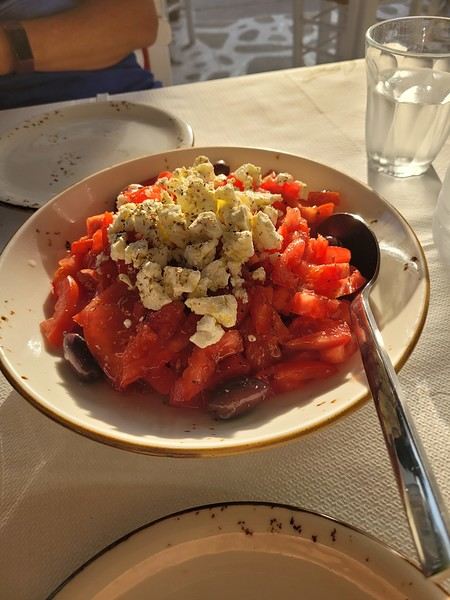 (Okay, this is actually a dakos with Naxos cheese, but I don’t have a photo of a Greek salad 😏).
Blue skies (lots of them), whitewashed villages with steep alleyways, hundreds of churches, and... thousands of stairs? Welcome to the Cyclades! 🙂
We’d been dreaming about this for a while, but in July-August—with the crowds—no way! Now that I can travel outside school holidays, the Cyclades are back on the agenda. And so begins a loooong period of planning and second-guessing, with countless itinerary changes: the Cyclades, yes, but which ones? I was fixated on Folegandros (we won’t be going after all) and really wanted to visit Delos. So, for this first trip, it’ll be: Mykonos (and Delos)-Naxos-Amorgos-Santorini.
Saturday 24/05: Departure from Orly on a Transavia flight, arriving in Mykonos in the late afternoon. We found a hotel that offers free transfers (pretty rare and not insignificant—it’s 25 € each way for just a few kilometers 😠) and at a reasonable price (83 € per night for B&B). Time for dinner already: Greek salad and souvlaki (we’re in Greece, right?)
(Okay, this is actually a dakos with Naxos cheese, but I don’t have a photo of a Greek salad 😏).USA 2022 Road Trip
During our first road trip across the United States, we covered 23,000 km and crossed 28 states in 53 days.
Originally, we had planned to drive Route 66 all the way to Oatman in Arizona and visit various national parks in the American West over a two-month period.
This itinerary was planned before our departure, and all the relevant information had been gathered to stick to the schedule.
Everything went so smoothly that we finished visiting the national parks well ahead of our planned return date.
It helped that having a bed, a portable toilet, and a cooler in our vehicle gave us some autonomy since we didn’t have to worry about accommodation.
So, we decided to extend our road trip to the cities of Nashville and Memphis in Tennessee.
We then headed to Louisiana to visit Baton Rouge and New Orleans.
We crossed Mississippi and Alabama before driving along Florida’s west coast all the way to Key West.
We returned via Florida’s east coast and then crossed the eastern U.S. states to get back to Quebec through the Jackman border crossing in Maine.
So, I invite you to keep reading this long recap, which will let you discover the different attractions we visited throughout this amazing journey.
Videos are included throughout the recap. Click on the image to start the video.
To jump to a specific post, here are the relevant links:
Route 66 - Illinois & Missouri Route 66 - St. Louis (Missouri) - Gateway Arch National Park Route 66 - Cuba (Missouri) - City Murals Route 66 - Springfield (Missouri) - Fantastic Caverns Route 66 - Kansas & Oklahoma Route 66 - Texas & Arizona Route 66 - Texas - The Stations of the Cross in Groom Route 66 - Texas - Panhandle - VW Slug Bug Ranch Texas - Palo Duro Canyon State Park - Juniper Trails Texas - Palo Duro Canyon State Park - The Lighthouse Trail Route 66 - Texas - Amarillo - Cadillac Ranch Route 66 - New Mexico - Santa Rosa Blue Hole New Mexico - Bandelier National Monument - Alcove House Trail via Main Loop Trail New Mexico - Bandelier National Monument - Tsankawi Ruins Trail New Mexico - White Rock Overlook Route 66 - New Mexico - Albuquerque - Old Town New Mexico - White Sands National Park New Mexico - White Sands National Park - Dune Life Nature Trail New Mexico - White Sands National Park - Playa Trail New Mexico - White Sands National Park - Interdune Boardwalk New Mexico - Gila Cliff Dwellings National Monument New Mexico - Grants - Ice Cave & Bandera Volcano New Mexico - Gallup - Pyramide Rock Trail & Church Rock Trail Arizona - Holbrook - Painted Desert Arizona - Petrified Forest National Park - Puerco Pueblo & Newspaper Rock Viewpoint Arizona - Petrified Forest National Park - Blue Mesa Arizona - Petrified Forest National Park - The Teepees, Agate Bridge & Jasper Forest Overlook Arizona - Petrified Forest National Park - Crystal Forest Trail Arizona - Petrified Forest National Park - Giant Logs Trail Arizona - Winslow - Two Guns Ghost Town Arizona - Cameron - Little Colorado River Gorge Overlooks Arizona - Grand Canyon National Park - Shoshone Point Trail Arizona - Grand Canyon National Park - Desert View Drive Arizona - Grand Canyon National Park - Rim Route (Orange) & Village Route (Blue) Arizona - Grand Canyon National Park - Hermit Route (Red Line) Route 66 - Arizona - Historic Town of Oatman Arizona - Bullhead City Community Park Nevada - Red Rock Canyon - Calico I & II & Sandstone Quarry Nevada - Red Rock Canyon - Willow Springs Nevada - Red Rock Canyon Lookouts Nevada - Valley of Fire State Park - White Domes Trail Nevada - Valley of Fire State Park - Seven Wonders Trail, Pink Canyon, Fire Wave Nevada - Valley of Fire State Park - Rainbow Vista Trail Nevada - Valley of Fire State Park - Mouse's Tank Trail Nevada - Valley of Fire State Park - Rock Formations Nevada - Valley of Fire State Park - Scenic Routes Nevada - Cathedral Gorge State Park - Slot Canyons Nevada - Cathedral Gorge State Park - Eagle Point & Miller Point Utah - Bryce Canyon National Park - Mossy Cave & Tropic Ditch Waterfall Trail Utah - Bryce Canyon National Park - Scenic Drive Utah - Zion National Park - Pa'rus Trail Utah - Zion National Park - Sand Bench Trail Utah - Zion National Park - Emerald Pools Trail Utah - Zion National Park - West Rim Trail (Trail connecting to Angels Landing) Utah - Zion National Park - Riverside Walk Utah - Zion National Park - Court of The Patriarchs & Big Bend Utah - Zion National Park - Mount Carmel Highway Scenic Drive Utah - Kanab - Jackson Flat Reservoir Utah - Toadstools Trail in Grand Staircase-Escalante National Monument Arizona - Page - Glen Canyon Dam Overlook Arizona - Page - Glen Canyon National Recreation Area Arizona - Page - Horseshoe Bend Overlook Arizona - Page - Upper Antelope Canyon Arizona - Page - Navajo Canyon Boat Tour at Lake Powell Arizona - Page - Antelope Canyon X Arizona - Canyon de Chelly National Monument - Chelly Canyon Arizona - Canyon de Chelly National Monument - Canyon del Muerto Arizona - Monument Valley Navajo Tribal Park Utah - Mexican Hat Utah - Mexican Hat - Goosenecks State Park Utah - Mexican Hat - Valley of the Gods Utah - The Moki Dugway Scenic Backway Utah - Blanding - Natural Bridges National Monument Utah - Lake Powell - Hite Crossing Bridge Utah - Lake Powell - Glen Canyon National Recreation Area - Hite Overlook Utah - Capitol Reef National Park - Chimney Rock Loop Trail Utah - Capitol Reef National Park - Hickman Bridge Trail Utah - Capitol Reef National Park - Grand Wash Trail Utah - Capitol Reef National Park - Sunset Point Trail Utah - Capitol Reef National Park - Goosenecks Trail Utah - Capitol Reef National Park - Viewpoints - Fruita Area Utah - Capitol Reef National Park - Viewpoints - Scenic Drive Utah - Capitol Reef National Park - Cassidy Arch Trail Utah - Capitol Reef National Park - On the way to Capitol Gorge Trailhead Utah - Capitol Reef National Park - Capitol Gorge Trailhead Utah - Monroe - Mystic Hot Springs Utah - Scenic Overlooks on UT-24, UT-119 & I-70 Utah - Arches National Park - Park Avenue Trail Utah - Arches National Park - Courthouse Towers Section's Viewpoints Utah - Arches National Park - Balanced Rock, Pothole Arch, Ham Rock & Garden of Eden Utah - Arches National Park - Double Arch Trail, Cove Arch, Cove of Caves & Panorama Point Utah - Arches National Park - Windows Loop & Turret Arch Trail Utah - Arches National Park - Delicate Arch Trail Utah - Arches National Park - Upper Delicate Arch Viewpoint Trail Utah - Arches National Park - Fiery Furnace Section - Viewpoints Utah - Arches National Park - Sand Dune Arch Trail Utah - Arches National Park - Skyline Arch Trail Utah - Arches National Park - Devils Garden Trail Utah - Dead Horse Point State Park - West Rim Trail Utah - Dead Horse Point State Park - East Rim Trail Utah - Moab - Utah State Route 279 (Potash Road) Utah - Moab - Shafer Trail - Potash Evaporation Ponds Utah - Moab - Potash Road Dinosaur Tracks and Petroglyphs Utah - Moab - Potash Road - Corona, Bowtie & Pinto Arches Trail Utah - Moab - Potash Road - Wall Street Climbing Area Utah - Moab - Kane Springs Road Utah - Moab - Kane Springs Road - Side By Side Adventure Utah - Moab - Kane Springs Road to Moab Utah - Canyonlands National Park - Island in the Sky - Mesa Arch Trail Utah - Canyonlands National Park - Island in the Sky - Aztec Butte Trail Utah - Canyonlands National Park - Island in the Sky - Whale Rock Trail Utah - Canyonlands National Park - Island in the Sky - Upheaval Dome Trail Utah - Canyonlands National Park - Island in the Sky - Grand View Point Overlook Trail Utah - Canyonlands National Park - Island in the Sky - White Rim Overlook Trail Utah - Canyonlands National Park - Island in the Sky - Overlooks Utah - Moab - Wilson Arch Utah - Monticello - Newspaper Rock State Historical Monument Utah - Canyonlands National Park - The Needles - Road Side Ruin Trail Utah - Canyonlands National Park - The Needles - Cave Spring Trail Utah - Canyonlands National Park - The Needles - Pothole Point Trail Utah - Canyonlands National Park - The Needles - Big Spring Canyon Overlook Trail Utah - Canyonlands National Park - The Needles - Overlooks Colorado - Mesa Verde National Park - Mesa Top Ruins Road Colorado - Mesa Verde National Park - Chapin Mesa Road Colorado - Mesa Verde National Park - Mesa Top Loop Colorado - Mesa Verde National Park - Wetherill Mesa Road Colorado - Great Sand Dunes National Park Colorado - Mosca - Zapata Falls Colorado - Colorado Springs - Garden of the Gods Colorado - Black Canyon of the Gunnison National Park Colorado - Gunnison - Curecanti National Recreation Area Colorado - Gunnison - Blue Mesa Dam & Reservoir Colorado - Lake Pueblo State Park (Pueblo Reservoir) Kentucky - Mayfield, 5 months after an EF4 tornado Tennessee - Nashville - Downtown Walking Tour Tennessee - Graceland Mansion - Home of Elvis Presley Tennessee - Graceland - Lisa Marie & Hound Dog II Jets Tennessee - Graceland - Elvis Presley Automobile Museum & Exhibits Tennessee - Exploring Memphis Louisiana - Exploring Baton Rouge Louisiana - Exploring Lafayette Louisiana - Exploring Houma Louisiana - New Orleans - French Quarter Tour Louisiana - New Orleans - Garden District Tour Louisiana - New Orleans - Creole Queen Mississippi River Cruise Florida - Clearwater Beach Florida - Sanibel Island - Bowman's Beach Florida - Siesta Key Beach Florida - Captiva Island - Turner Beach Florida - Key Largo - Sunset Florida - Key West - Smathers Beach Florida - Miami Beach - Art Deco District Florida - Miami Beach South Carolina - Myrtle Beach Virginia - Virginia Beach Maine - Scarborough - Pine Point Beach
Originally, we had planned to drive Route 66 all the way to Oatman in Arizona and visit various national parks in the American West over a two-month period.
This itinerary was planned before our departure, and all the relevant information had been gathered to stick to the schedule.
Everything went so smoothly that we finished visiting the national parks well ahead of our planned return date.
It helped that having a bed, a portable toilet, and a cooler in our vehicle gave us some autonomy since we didn’t have to worry about accommodation.
So, we decided to extend our road trip to the cities of Nashville and Memphis in Tennessee.
We then headed to Louisiana to visit Baton Rouge and New Orleans.
We crossed Mississippi and Alabama before driving along Florida’s west coast all the way to Key West.
We returned via Florida’s east coast and then crossed the eastern U.S. states to get back to Quebec through the Jackman border crossing in Maine.
So, I invite you to keep reading this long recap, which will let you discover the different attractions we visited throughout this amazing journey.
Videos are included throughout the recap. Click on the image to start the video.
To jump to a specific post, here are the relevant links:
Route 66 - Illinois & Missouri Route 66 - St. Louis (Missouri) - Gateway Arch National Park Route 66 - Cuba (Missouri) - City Murals Route 66 - Springfield (Missouri) - Fantastic Caverns Route 66 - Kansas & Oklahoma Route 66 - Texas & Arizona Route 66 - Texas - The Stations of the Cross in Groom Route 66 - Texas - Panhandle - VW Slug Bug Ranch Texas - Palo Duro Canyon State Park - Juniper Trails Texas - Palo Duro Canyon State Park - The Lighthouse Trail Route 66 - Texas - Amarillo - Cadillac Ranch Route 66 - New Mexico - Santa Rosa Blue Hole New Mexico - Bandelier National Monument - Alcove House Trail via Main Loop Trail New Mexico - Bandelier National Monument - Tsankawi Ruins Trail New Mexico - White Rock Overlook Route 66 - New Mexico - Albuquerque - Old Town New Mexico - White Sands National Park New Mexico - White Sands National Park - Dune Life Nature Trail New Mexico - White Sands National Park - Playa Trail New Mexico - White Sands National Park - Interdune Boardwalk New Mexico - Gila Cliff Dwellings National Monument New Mexico - Grants - Ice Cave & Bandera Volcano New Mexico - Gallup - Pyramide Rock Trail & Church Rock Trail Arizona - Holbrook - Painted Desert Arizona - Petrified Forest National Park - Puerco Pueblo & Newspaper Rock Viewpoint Arizona - Petrified Forest National Park - Blue Mesa Arizona - Petrified Forest National Park - The Teepees, Agate Bridge & Jasper Forest Overlook Arizona - Petrified Forest National Park - Crystal Forest Trail Arizona - Petrified Forest National Park - Giant Logs Trail Arizona - Winslow - Two Guns Ghost Town Arizona - Cameron - Little Colorado River Gorge Overlooks Arizona - Grand Canyon National Park - Shoshone Point Trail Arizona - Grand Canyon National Park - Desert View Drive Arizona - Grand Canyon National Park - Rim Route (Orange) & Village Route (Blue) Arizona - Grand Canyon National Park - Hermit Route (Red Line) Route 66 - Arizona - Historic Town of Oatman Arizona - Bullhead City Community Park Nevada - Red Rock Canyon - Calico I & II & Sandstone Quarry Nevada - Red Rock Canyon - Willow Springs Nevada - Red Rock Canyon Lookouts Nevada - Valley of Fire State Park - White Domes Trail Nevada - Valley of Fire State Park - Seven Wonders Trail, Pink Canyon, Fire Wave Nevada - Valley of Fire State Park - Rainbow Vista Trail Nevada - Valley of Fire State Park - Mouse's Tank Trail Nevada - Valley of Fire State Park - Rock Formations Nevada - Valley of Fire State Park - Scenic Routes Nevada - Cathedral Gorge State Park - Slot Canyons Nevada - Cathedral Gorge State Park - Eagle Point & Miller Point Utah - Bryce Canyon National Park - Mossy Cave & Tropic Ditch Waterfall Trail Utah - Bryce Canyon National Park - Scenic Drive Utah - Zion National Park - Pa'rus Trail Utah - Zion National Park - Sand Bench Trail Utah - Zion National Park - Emerald Pools Trail Utah - Zion National Park - West Rim Trail (Trail connecting to Angels Landing) Utah - Zion National Park - Riverside Walk Utah - Zion National Park - Court of The Patriarchs & Big Bend Utah - Zion National Park - Mount Carmel Highway Scenic Drive Utah - Kanab - Jackson Flat Reservoir Utah - Toadstools Trail in Grand Staircase-Escalante National Monument Arizona - Page - Glen Canyon Dam Overlook Arizona - Page - Glen Canyon National Recreation Area Arizona - Page - Horseshoe Bend Overlook Arizona - Page - Upper Antelope Canyon Arizona - Page - Navajo Canyon Boat Tour at Lake Powell Arizona - Page - Antelope Canyon X Arizona - Canyon de Chelly National Monument - Chelly Canyon Arizona - Canyon de Chelly National Monument - Canyon del Muerto Arizona - Monument Valley Navajo Tribal Park Utah - Mexican Hat Utah - Mexican Hat - Goosenecks State Park Utah - Mexican Hat - Valley of the Gods Utah - The Moki Dugway Scenic Backway Utah - Blanding - Natural Bridges National Monument Utah - Lake Powell - Hite Crossing Bridge Utah - Lake Powell - Glen Canyon National Recreation Area - Hite Overlook Utah - Capitol Reef National Park - Chimney Rock Loop Trail Utah - Capitol Reef National Park - Hickman Bridge Trail Utah - Capitol Reef National Park - Grand Wash Trail Utah - Capitol Reef National Park - Sunset Point Trail Utah - Capitol Reef National Park - Goosenecks Trail Utah - Capitol Reef National Park - Viewpoints - Fruita Area Utah - Capitol Reef National Park - Viewpoints - Scenic Drive Utah - Capitol Reef National Park - Cassidy Arch Trail Utah - Capitol Reef National Park - On the way to Capitol Gorge Trailhead Utah - Capitol Reef National Park - Capitol Gorge Trailhead Utah - Monroe - Mystic Hot Springs Utah - Scenic Overlooks on UT-24, UT-119 & I-70 Utah - Arches National Park - Park Avenue Trail Utah - Arches National Park - Courthouse Towers Section's Viewpoints Utah - Arches National Park - Balanced Rock, Pothole Arch, Ham Rock & Garden of Eden Utah - Arches National Park - Double Arch Trail, Cove Arch, Cove of Caves & Panorama Point Utah - Arches National Park - Windows Loop & Turret Arch Trail Utah - Arches National Park - Delicate Arch Trail Utah - Arches National Park - Upper Delicate Arch Viewpoint Trail Utah - Arches National Park - Fiery Furnace Section - Viewpoints Utah - Arches National Park - Sand Dune Arch Trail Utah - Arches National Park - Skyline Arch Trail Utah - Arches National Park - Devils Garden Trail Utah - Dead Horse Point State Park - West Rim Trail Utah - Dead Horse Point State Park - East Rim Trail Utah - Moab - Utah State Route 279 (Potash Road) Utah - Moab - Shafer Trail - Potash Evaporation Ponds Utah - Moab - Potash Road Dinosaur Tracks and Petroglyphs Utah - Moab - Potash Road - Corona, Bowtie & Pinto Arches Trail Utah - Moab - Potash Road - Wall Street Climbing Area Utah - Moab - Kane Springs Road Utah - Moab - Kane Springs Road - Side By Side Adventure Utah - Moab - Kane Springs Road to Moab Utah - Canyonlands National Park - Island in the Sky - Mesa Arch Trail Utah - Canyonlands National Park - Island in the Sky - Aztec Butte Trail Utah - Canyonlands National Park - Island in the Sky - Whale Rock Trail Utah - Canyonlands National Park - Island in the Sky - Upheaval Dome Trail Utah - Canyonlands National Park - Island in the Sky - Grand View Point Overlook Trail Utah - Canyonlands National Park - Island in the Sky - White Rim Overlook Trail Utah - Canyonlands National Park - Island in the Sky - Overlooks Utah - Moab - Wilson Arch Utah - Monticello - Newspaper Rock State Historical Monument Utah - Canyonlands National Park - The Needles - Road Side Ruin Trail Utah - Canyonlands National Park - The Needles - Cave Spring Trail Utah - Canyonlands National Park - The Needles - Pothole Point Trail Utah - Canyonlands National Park - The Needles - Big Spring Canyon Overlook Trail Utah - Canyonlands National Park - The Needles - Overlooks Colorado - Mesa Verde National Park - Mesa Top Ruins Road Colorado - Mesa Verde National Park - Chapin Mesa Road Colorado - Mesa Verde National Park - Mesa Top Loop Colorado - Mesa Verde National Park - Wetherill Mesa Road Colorado - Great Sand Dunes National Park Colorado - Mosca - Zapata Falls Colorado - Colorado Springs - Garden of the Gods Colorado - Black Canyon of the Gunnison National Park Colorado - Gunnison - Curecanti National Recreation Area Colorado - Gunnison - Blue Mesa Dam & Reservoir Colorado - Lake Pueblo State Park (Pueblo Reservoir) Kentucky - Mayfield, 5 months after an EF4 tornado Tennessee - Nashville - Downtown Walking Tour Tennessee - Graceland Mansion - Home of Elvis Presley Tennessee - Graceland - Lisa Marie & Hound Dog II Jets Tennessee - Graceland - Elvis Presley Automobile Museum & Exhibits Tennessee - Exploring Memphis Louisiana - Exploring Baton Rouge Louisiana - Exploring Lafayette Louisiana - Exploring Houma Louisiana - New Orleans - French Quarter Tour Louisiana - New Orleans - Garden District Tour Louisiana - New Orleans - Creole Queen Mississippi River Cruise Florida - Clearwater Beach Florida - Sanibel Island - Bowman's Beach Florida - Siesta Key Beach Florida - Captiva Island - Turner Beach Florida - Key Largo - Sunset Florida - Key West - Smathers Beach Florida - Miami Beach - Art Deco District Florida - Miami Beach South Carolina - Myrtle Beach Virginia - Virginia Beach Maine - Scarborough - Pine Point Beach
All Over Thailand
You can post your personal photos in the following thread: https://voyageforum.com/forum/quelque-part-en-thailande-d10655574/
This travel journal is therefore intended solely for my photos, to present a consistent style. All the shots were taken with a simple Samsung Galaxy smartphone and with whatever was at hand.
All stays combined, I’ve spent the equivalent of a year at most in Thailand, and I’m no great expert. However, after many trips, lots of reading on VoyageForum and other sites, and conversations with many locals as well as expats, my view of the country is becoming clearer, though it’s constantly evolving. You never stop discovering and learning.
I guess I wanted to deliver a puzzle, mainly for those who want to get an idea of the country here and for those who feel nostalgic about it. I don’t know if this minimalist sharing will interest anyone, but it’ll do me good to put it together. After so many months without traveling and then these other long months with VF closed, there’s plenty of material available.
There’ll be a mix of places, periods, and subjects, but it might well be intentional.

I suspect many Thais have dogs because they make excellent guardians for the home. Nothing better to deter burglars or to signal the presence of a snake. You’ll often see Thais tapping the top of their dog’s head, but don’t be fooled: it’s a sign of affection from them. Judging by the dogs’ reactions, they’re used to it.
Thailand is one of the countries on the planet where rabies is still present, so keep that in mind. It’s not just bites that can be dangerous, so don’t let just any dog lick you. Especially on a wound, of course. Even though dogs often fear humans—this dangerous and unpredictable predator—we still need to stay cautious. Be careful when walking into alleys because the dog will defend its master’s big yard. Be careful at night, and be careful when they’re in packs. It sometimes crosses our minds that Thailand isn’t all that made for walking around, and dogs are one of the reasons. That said, it’s not uncommon to see them chasing bikes or scooters. Cars, though? Much rarer—they’re too big.
It seems Thais prefer to give their dogs freedom by not locking them behind gates. Though sometimes the gate is closed, the little side door is wide open. Oh, and sometimes there’s no gate in front of the property, or it’s been full of holes for years.
You’ll often see dogs sleeping on the roadside, sometimes right on the road. When you approach, they move aside nonchalantly—or not at all. It’s less funny when they suddenly appear from thick vegetation, reminding visitors not to drive too fast. As a result, you’ll notice that dogs with injuries or missing legs aren’t that rare.
Since they believe in reincarnation and respect for all forms of life, they don’t chase dog packs away too much, and they don’t sterilize them enough. When you see a small pack roaming freely in the countryside, you think twice about running into them at the edge of a field. A darker side of this is that euthanasia isn’t often practiced. Twice, we saw dogs at death’s door in temples, enduring terrible suffering with no one to help. The image (and the smell) of one of them, agonizing and exuding the stench of death, still comes back to me sometimes.
Some of you may have seen the YouTube vlog of a French woman living in Phuket who was given a little pig by her Thai friends. The animal, well-fed, quickly became a happy and enormous beast with its own garden. Yet it didn’t take long for it to fall seriously ill and become incurable. In her video, the French woman described how difficult it was to find a vet willing to perform euthanasia.
You’ll often see bowls by the side of the road. Thais leave food and water there for stray cats and dogs. Overall, they have a big heart for animals.
If you ever pop into a shopping mall, you might see people pushing their small dogs in strollers. It’s not just for fun—these strollers are provided for customers to put their pets in, otherwise you can’t bring them inside. It looks a bit odd when you expect to see a baby.
This travel journal is therefore intended solely for my photos, to present a consistent style. All the shots were taken with a simple Samsung Galaxy smartphone and with whatever was at hand.
All stays combined, I’ve spent the equivalent of a year at most in Thailand, and I’m no great expert. However, after many trips, lots of reading on VoyageForum and other sites, and conversations with many locals as well as expats, my view of the country is becoming clearer, though it’s constantly evolving. You never stop discovering and learning.
I guess I wanted to deliver a puzzle, mainly for those who want to get an idea of the country here and for those who feel nostalgic about it. I don’t know if this minimalist sharing will interest anyone, but it’ll do me good to put it together. After so many months without traveling and then these other long months with VF closed, there’s plenty of material available.
There’ll be a mix of places, periods, and subjects, but it might well be intentional.
I suspect many Thais have dogs because they make excellent guardians for the home. Nothing better to deter burglars or to signal the presence of a snake. You’ll often see Thais tapping the top of their dog’s head, but don’t be fooled: it’s a sign of affection from them. Judging by the dogs’ reactions, they’re used to it.
Thailand is one of the countries on the planet where rabies is still present, so keep that in mind. It’s not just bites that can be dangerous, so don’t let just any dog lick you. Especially on a wound, of course. Even though dogs often fear humans—this dangerous and unpredictable predator—we still need to stay cautious. Be careful when walking into alleys because the dog will defend its master’s big yard. Be careful at night, and be careful when they’re in packs. It sometimes crosses our minds that Thailand isn’t all that made for walking around, and dogs are one of the reasons. That said, it’s not uncommon to see them chasing bikes or scooters. Cars, though? Much rarer—they’re too big.
It seems Thais prefer to give their dogs freedom by not locking them behind gates. Though sometimes the gate is closed, the little side door is wide open. Oh, and sometimes there’s no gate in front of the property, or it’s been full of holes for years.
You’ll often see dogs sleeping on the roadside, sometimes right on the road. When you approach, they move aside nonchalantly—or not at all. It’s less funny when they suddenly appear from thick vegetation, reminding visitors not to drive too fast. As a result, you’ll notice that dogs with injuries or missing legs aren’t that rare.
Since they believe in reincarnation and respect for all forms of life, they don’t chase dog packs away too much, and they don’t sterilize them enough. When you see a small pack roaming freely in the countryside, you think twice about running into them at the edge of a field. A darker side of this is that euthanasia isn’t often practiced. Twice, we saw dogs at death’s door in temples, enduring terrible suffering with no one to help. The image (and the smell) of one of them, agonizing and exuding the stench of death, still comes back to me sometimes.
Some of you may have seen the YouTube vlog of a French woman living in Phuket who was given a little pig by her Thai friends. The animal, well-fed, quickly became a happy and enormous beast with its own garden. Yet it didn’t take long for it to fall seriously ill and become incurable. In her video, the French woman described how difficult it was to find a vet willing to perform euthanasia.
You’ll often see bowls by the side of the road. Thais leave food and water there for stray cats and dogs. Overall, they have a big heart for animals.
If you ever pop into a shopping mall, you might see people pushing their small dogs in strollers. It’s not just for fun—these strollers are provided for customers to put their pets in, otherwise you can’t bring them inside. It looks a bit odd when you expect to see a baby.
Voyage 5 mois et 3 semaines en Amérique du Sud
Bonjour,
Il n'est jamais trop tard pour rendre compte de son voyage. Le confinement me laisse enfin du temps pour le faire.
Je suis parti le 17 août 2017 et je suis rentré le 7 février 2018. Entre temps, je suis allé en Argentine par cargo puis une fois sur ce continent, j'ai visité l'Uruguay, l'Argentine et le Chili.
Durant tout ce voyage, j'ai tenu un carnet journalier.
Je me propose de vous le livrer.
On part en vadrouille dans l'ouest américain! Oui, encore...
En ces temps difficiles qui nous obligent à trouver des occupations, je vous soumets ici un carnet que j'avais rédigé il y a quelques années et que je n'ai jamais publié ici... Bonne lecture (pour ceux que ça intéresse...)...
24 juillet - Itinéraire d’une famille gâtée
Envie de t’évader ? Envie de rêver ? Envie de t’amuser ? Oui ? Alors tu as frappé à la bonne adresse... Plus précisément à l’adresse de celui qui a attrapé un virus… En l’occurrence, moi… Et ce virus, pas question de m’en débarrasser en me bourrant d’antibiotiques. Non seulement, les antibiotiques, ce n’est pas automatique, mais ce virus-là, j’en prends grand soin. Je l’entretiens, même… Ce virus, c’est l’étasunite ! Je l’ai contracté le jour où j’ai posé mes arpions chez l’oncle Sam pour la première fois, il y a une décennie de cela. Tout ça ne me rajeunit pas mais depuis ce fameux jour, lui et moi, nous ne nous sommes plus jamais quittés. Un proverbe dit à ce sujet que si tu vas aux Etats-Unis une fois, tu y reviendras un jour… Ben moi, depuis, j’y suis même retourné deux autres fois ! Et figure-toi que si tu lis ces quelques lignes, c’est que je m’apprête à y retourner pour une quatrième vadrouille !... Pour cette fois-ci, je vais accomplir un de mes rêves ! Me faire la route 66 sur mon Harley avec une belle brune accrochée à ma taille... Manque de bol, ma femme est blonde, je n'ai pas le permis moto et nous avons deux louloutes de quatre et sept ans… Va donc falloir que je revoie mes plans...
Bon, si tu es un lecteur assidu de nos précédentes vadrouilles, nous n’avons plus de secret pour toi, si bien que tu sais déjà que nous sommes quatre, juste un an de plus par rapport à la dernière fois… Il y a bien évidemment Sandrine, ma femme alias le portefeuille ; Sasha, notre petite globetrotteuse de quatre ans ; et Anna notre routarde de sept ans et plus toutes ses dents... Ah, et je m’oubliais ! Moi, Franck, la trentaine bien tassée, alias le conducteur, le tour opérateur, le narrateur, le cuisinier, le… Oui, je sais, moi aussi, j’aimerais bien déléguer… Ah, mais j’oublie encore quelqu’un !… Toi… Mais bon, sauf le respect que je te dois, tu ne seras une nouvelle fois que le spectateur du film que nous allons tourner et interpréter… D’ailleurs, quel en sera le titre ?... Et bien après réflexion, on a le choix entre « Voyage entre geysers et déserts », ou alors « Sous le soleil de Beverly Hills »… Pour ce coup-là, en espérant ne pas les vexer, on décide de poser un lapin à Brandon et Brenda… Car oui, c’est décidé, cette nouvelle édition sera composée d'indiens, de geysers, de trappeurs, de pionniers, de bisons, de chercheurs d'or, de hors-la-loi, de ranchs et de cowboys ! A nous les grands espaces… et les gros hamburgers !!! A nous l’ouest américain et ses films qui donnent tant envie : Délivrance, la colline a des yeux, Shining, The Descent, ...
Mais un voyage comme celui-là, ça se prépare un ‘tiot peu. Premièrement, il faut du blé, du flouze, du fric, du pognon, des pépettes, de la caillasse… Ben oui, ça coûte cher tout ça, donc à moins de faire comme le PSG et te faire subventionner par un investisseur qatari, il va falloir que tu en mettes de côté. Deuxièmement, il faut un minimum de travail de préparation. Et je commencerai mon histoire par un retour dans le passé, un bond dans le temps pour revenir pile poil au moment où Sandrine a enfin craqué sous mes coups de butoir et m’a donné son ô combien précieuse approbation… « Allez, ok, c’est bon, fais-toi plaisir ! » Sans avoir réellement conscience de la portée de ces quelques mots, elle venait de me signer un contrat de travail d’un an ! Car moi, ni une, ni deux, j'ai employé toute une équipe de lutins pour m'aider à préparer mon itinéraire. Lecture de carnets de voyage, questions sur des forums, épluchage de guides, visionnage de films, essorage d’internet, … Au final, je dois dire que je suis plus que satisfait de leur boulot ! Ce qui me permet non pas de faire un bilan puisqu'heureusement, le voyage n'est pas commencé, mais plutôt un petit compte-rendu chiffré de ce qui nous attend. Huit états à traverser ou à effleurer, plus de cinq mille kilomètres à parcourir, vingt jours pleins sur place, deux hôtels, quatorze campings différents, huit heures de décalage... Mes trois blondes vont-elles le supporter ? Optimiste que je suis, je mise sur un grand « Oui » ! D’ailleurs, pour les préparer, j’ai mis en place un programme intensif trois mois avant le départ : Marche autour de notre immense propriété, westerns tous les soirs, Coca et hamburgers à volonté à tous les repas !... Et oui, qui ménage sa monture voyage plus souvent !
Avant de tailler la route, je profite de cette intro pour publier une petite annonce à destination des cambrioleurs amateurs de textes de voyage : passez votre route, ma maison est équipée d’une alarme biométrique avec double varifocale et matrice de commutation. De plus, j’ai loué à un pote du neuf trois son gros pitbull pour l’occasion. Sans compter que pendant nos vacances, ma maison va être occupée par mes parents qui sont tous les deux experts en arts martiaux !... D’ailleurs, pourquoi je te raconte ces bobards alors que tu ne connais même pas mon adresse… C'est le 25, avenue des canaris à Triffouillis-sur-Retourne... Euh, merci de ne pas m’envoyer de carte postale à l'adresse ci-dessus... c'est une fausse !
Bon, chut, ça y est, c’est l’heure de l’évaluation… On va savoir si toute la famille est prête pour le grand départ : « Sandrine, donne-moi les huit états dans lesquels nous allons poser les pieds... - Colorado, Wyoming, Nebraska, Dakota du sud, Montana, Idaho, Utah et... euh... mince, oh, je l’ai sur le bout de la langue… Ah oui, l’Arizona !!!… - Mouais… C’était moins une… Encore un peu et tu n’partais pas avec nous ! Et toi, Anna, cite-moi les quatre présidents sculptés sur le Mont Rushmore ? - Abram Licol, Tomasse Washington, George Jeffessonne et Theodore Rousevelle... - Ok, on va dire que c’est bon… Et toi, Sasha, dans quel pays allons-nous cet été ? - Les Jétajuniiiiis de l’Amérique de Mickey ! » Ok, c’est bon, elles sont fin prêtes ! Attention, départ imminent !
24 juillet - Itinéraire d’une famille gâtée
Envie de t’évader ? Envie de rêver ? Envie de t’amuser ? Oui ? Alors tu as frappé à la bonne adresse... Plus précisément à l’adresse de celui qui a attrapé un virus… En l’occurrence, moi… Et ce virus, pas question de m’en débarrasser en me bourrant d’antibiotiques. Non seulement, les antibiotiques, ce n’est pas automatique, mais ce virus-là, j’en prends grand soin. Je l’entretiens, même… Ce virus, c’est l’étasunite ! Je l’ai contracté le jour où j’ai posé mes arpions chez l’oncle Sam pour la première fois, il y a une décennie de cela. Tout ça ne me rajeunit pas mais depuis ce fameux jour, lui et moi, nous ne nous sommes plus jamais quittés. Un proverbe dit à ce sujet que si tu vas aux Etats-Unis une fois, tu y reviendras un jour… Ben moi, depuis, j’y suis même retourné deux autres fois ! Et figure-toi que si tu lis ces quelques lignes, c’est que je m’apprête à y retourner pour une quatrième vadrouille !... Pour cette fois-ci, je vais accomplir un de mes rêves ! Me faire la route 66 sur mon Harley avec une belle brune accrochée à ma taille... Manque de bol, ma femme est blonde, je n'ai pas le permis moto et nous avons deux louloutes de quatre et sept ans… Va donc falloir que je revoie mes plans...
Bon, si tu es un lecteur assidu de nos précédentes vadrouilles, nous n’avons plus de secret pour toi, si bien que tu sais déjà que nous sommes quatre, juste un an de plus par rapport à la dernière fois… Il y a bien évidemment Sandrine, ma femme alias le portefeuille ; Sasha, notre petite globetrotteuse de quatre ans ; et Anna notre routarde de sept ans et plus toutes ses dents... Ah, et je m’oubliais ! Moi, Franck, la trentaine bien tassée, alias le conducteur, le tour opérateur, le narrateur, le cuisinier, le… Oui, je sais, moi aussi, j’aimerais bien déléguer… Ah, mais j’oublie encore quelqu’un !… Toi… Mais bon, sauf le respect que je te dois, tu ne seras une nouvelle fois que le spectateur du film que nous allons tourner et interpréter… D’ailleurs, quel en sera le titre ?... Et bien après réflexion, on a le choix entre « Voyage entre geysers et déserts », ou alors « Sous le soleil de Beverly Hills »… Pour ce coup-là, en espérant ne pas les vexer, on décide de poser un lapin à Brandon et Brenda… Car oui, c’est décidé, cette nouvelle édition sera composée d'indiens, de geysers, de trappeurs, de pionniers, de bisons, de chercheurs d'or, de hors-la-loi, de ranchs et de cowboys ! A nous les grands espaces… et les gros hamburgers !!! A nous l’ouest américain et ses films qui donnent tant envie : Délivrance, la colline a des yeux, Shining, The Descent, ...
Mais un voyage comme celui-là, ça se prépare un ‘tiot peu. Premièrement, il faut du blé, du flouze, du fric, du pognon, des pépettes, de la caillasse… Ben oui, ça coûte cher tout ça, donc à moins de faire comme le PSG et te faire subventionner par un investisseur qatari, il va falloir que tu en mettes de côté. Deuxièmement, il faut un minimum de travail de préparation. Et je commencerai mon histoire par un retour dans le passé, un bond dans le temps pour revenir pile poil au moment où Sandrine a enfin craqué sous mes coups de butoir et m’a donné son ô combien précieuse approbation… « Allez, ok, c’est bon, fais-toi plaisir ! » Sans avoir réellement conscience de la portée de ces quelques mots, elle venait de me signer un contrat de travail d’un an ! Car moi, ni une, ni deux, j'ai employé toute une équipe de lutins pour m'aider à préparer mon itinéraire. Lecture de carnets de voyage, questions sur des forums, épluchage de guides, visionnage de films, essorage d’internet, … Au final, je dois dire que je suis plus que satisfait de leur boulot ! Ce qui me permet non pas de faire un bilan puisqu'heureusement, le voyage n'est pas commencé, mais plutôt un petit compte-rendu chiffré de ce qui nous attend. Huit états à traverser ou à effleurer, plus de cinq mille kilomètres à parcourir, vingt jours pleins sur place, deux hôtels, quatorze campings différents, huit heures de décalage... Mes trois blondes vont-elles le supporter ? Optimiste que je suis, je mise sur un grand « Oui » ! D’ailleurs, pour les préparer, j’ai mis en place un programme intensif trois mois avant le départ : Marche autour de notre immense propriété, westerns tous les soirs, Coca et hamburgers à volonté à tous les repas !... Et oui, qui ménage sa monture voyage plus souvent !
Avant de tailler la route, je profite de cette intro pour publier une petite annonce à destination des cambrioleurs amateurs de textes de voyage : passez votre route, ma maison est équipée d’une alarme biométrique avec double varifocale et matrice de commutation. De plus, j’ai loué à un pote du neuf trois son gros pitbull pour l’occasion. Sans compter que pendant nos vacances, ma maison va être occupée par mes parents qui sont tous les deux experts en arts martiaux !... D’ailleurs, pourquoi je te raconte ces bobards alors que tu ne connais même pas mon adresse… C'est le 25, avenue des canaris à Triffouillis-sur-Retourne... Euh, merci de ne pas m’envoyer de carte postale à l'adresse ci-dessus... c'est une fausse !
Bon, chut, ça y est, c’est l’heure de l’évaluation… On va savoir si toute la famille est prête pour le grand départ : « Sandrine, donne-moi les huit états dans lesquels nous allons poser les pieds... - Colorado, Wyoming, Nebraska, Dakota du sud, Montana, Idaho, Utah et... euh... mince, oh, je l’ai sur le bout de la langue… Ah oui, l’Arizona !!!… - Mouais… C’était moins une… Encore un peu et tu n’partais pas avec nous ! Et toi, Anna, cite-moi les quatre présidents sculptés sur le Mont Rushmore ? - Abram Licol, Tomasse Washington, George Jeffessonne et Theodore Rousevelle... - Ok, on va dire que c’est bon… Et toi, Sasha, dans quel pays allons-nous cet été ? - Les Jétajuniiiiis de l’Amérique de Mickey ! » Ok, c’est bon, elles sont fin prêtes ! Attention, départ imminent !
Oman, le pays des Mille moins Une Merveilles
Bonjour à tous,
Petit clin d'oeil au carnet d'Isabelle (Rouquine 38) quant au choix du titre 😉.
Pourquoi "mille moins une"? Tout simplement parce qu'en 10 jours, on en voit moins qu'en 14 et qu'en berline on en voit (un peu) moins qu'en 4x4. Exit donc le Dhofar et le Jebel Akhdar. Pour ce qui est des 999 autres merveilles, c'est pas faute de ne pas vous avoir prévenus: il va y avoir des redites!
C'est parti.... Muriel
Petit clin d'oeil au carnet d'Isabelle (Rouquine 38) quant au choix du titre 😉.
Pourquoi "mille moins une"? Tout simplement parce qu'en 10 jours, on en voit moins qu'en 14 et qu'en berline on en voit (un peu) moins qu'en 4x4. Exit donc le Dhofar et le Jebel Akhdar. Pour ce qui est des 999 autres merveilles, c'est pas faute de ne pas vous avoir prévenus: il va y avoir des redites!
C'est parti.... Muriel