Results for "ski+|+3+>+99"
8486 results found.
La Grèce à vélo (vos avis et retours d'expériences) English translation pending
Salut,
J'aurais voulu avoir quelques retours d'expériences de cyclistes qui auraient parcouru la Grèce, c'est une destination qui me plaît bien, peut-être l'année prochaine :)
Merci d'avance.
Gilles
Stratégie du backpacker pour la nuit en octobre au Sud Lipez English translation pending
Hello,
J'ai cherché sur le forum et sur le web avant mais c'est pas très claire pour moi.
Je reviens de chez Décathlon et le sac de couchage à -15 degrès pour le confort me rebute, pas vraiment le prix, c'est une question de prix, mais la place que ça prend dans le sac!
Alors j'ai acheté des t shirt thermiques, un sweat thermiques aussi, j'ai un pantalon de ski, et des chaussette aussi pour les nuits froides.
Alors mon agence ( Tupiza Tours ) loue des sac de couchages ( sleeping bags ) donc je suppose que c'est ça..niveau hygiène j'en sais rien mais je compte du coup acheter un sac à viande pour les nuits et louer un sac chez eux.
Pour trois nuits je me vois mal transporter un gros sac de couchage depuis le Pérou.
Autre chose: Comment me conseillez vous d'organiser les nuits, je dors en refuse en fin octobre ( Sud Lipez ) l'idée était de louer un sac de couchage avec l'agence et acheter ceci pour protéger le duvet : www.decathlon.ch/...soie-fr-s107085.html
Pour les nuits faut dormir avec un t shirt thermique sans pantalon de ski, pour éviter de suer et du coup etre humide et etre mal au matin ? J'ai jamais dormi dans ces conditions, j'ai vécu les très chauds mais jamais les très froid la nuit ;)
Merci pour vos retours Nico
J'ai cherché sur le forum et sur le web avant mais c'est pas très claire pour moi.
Je reviens de chez Décathlon et le sac de couchage à -15 degrès pour le confort me rebute, pas vraiment le prix, c'est une question de prix, mais la place que ça prend dans le sac!
Alors j'ai acheté des t shirt thermiques, un sweat thermiques aussi, j'ai un pantalon de ski, et des chaussette aussi pour les nuits froides.
Alors mon agence ( Tupiza Tours ) loue des sac de couchages ( sleeping bags ) donc je suppose que c'est ça..niveau hygiène j'en sais rien mais je compte du coup acheter un sac à viande pour les nuits et louer un sac chez eux.
Pour trois nuits je me vois mal transporter un gros sac de couchage depuis le Pérou.
Autre chose: Comment me conseillez vous d'organiser les nuits, je dors en refuse en fin octobre ( Sud Lipez ) l'idée était de louer un sac de couchage avec l'agence et acheter ceci pour protéger le duvet : www.decathlon.ch/...soie-fr-s107085.html
Pour les nuits faut dormir avec un t shirt thermique sans pantalon de ski, pour éviter de suer et du coup etre humide et etre mal au matin ? J'ai jamais dormi dans ces conditions, j'ai vécu les très chauds mais jamais les très froid la nuit ;)
Merci pour vos retours Nico
Voyage en France en hiver et activités English translation pending
Allo!
Nous aurions l'opportunité de faire le saut vers la France en atterrissant sur Paris en février ou mars 2019, ma femme et moi, pour 10 ou 14 jours. Je sais, c'est un (pas mal) hors saison, mais je me disais qu'il y aurais ici quelque personnes bien intentionnées pour m'aiguiller ou me conseiller sur des activités.
Dans mon cas, c'est ma 1ère fois en France, mais je suis passé en Europe centrale il y a une vingtaine d'années (Allemagne, Autriche, Slovénie, Croatie, Nord-est de l'Italie et Bosnie-Herzégovine). Pour ma conjointe, c'est son baptême européen.
Merci de vos conseils!
Nous aurions l'opportunité de faire le saut vers la France en atterrissant sur Paris en février ou mars 2019, ma femme et moi, pour 10 ou 14 jours. Je sais, c'est un (pas mal) hors saison, mais je me disais qu'il y aurais ici quelque personnes bien intentionnées pour m'aiguiller ou me conseiller sur des activités.
Dans mon cas, c'est ma 1ère fois en France, mais je suis passé en Europe centrale il y a une vingtaine d'années (Allemagne, Autriche, Slovénie, Croatie, Nord-est de l'Italie et Bosnie-Herzégovine). Pour ma conjointe, c'est son baptême européen.
Merci de vos conseils!
Kayaking in Greenland - Disko Bay: Circumnavigation of Arve Princess Island
After two rather rainy kayaking experiences in Alaska at the end of summer in recent years, we chose a slightly drier destination for this late August 2018: the west coast of Greenland. The temperature will certainly be a bit colder, especially at this time of year, but we’re betting on a beautiful end to the season. According to temperature charts, it should be around 5 to 10°C with a few night frosts. The tundra will already have its autumn colors, and by the end of the trip, we might be lucky enough to see the northern lights when the nights get darker.
We’re setting off as a group of three in two inflatable double-seater kayaks (Gumotex) brought from France. The plan is to spend two weeks circumnavigating Arve Princess Island, located north of Ilulissat in Disko Bay, with a possible boat drop-off at the southern tip of the island.
This seems like a fairly classic route in the area—we found several descriptions online (thanks to the authors). With their help and Google Earth, we identified all potential campsites and entered their coordinates into a GPS. The western part of the island, facing the bay, seems ideal for whale watching, while the more rugged eastern side offers access to several glacial walls. We’re somewhat familiar with the area from two winter expeditions on skis and pulkas.
Plus, the commitment is limited due to the island’s proximity to several small villages, including Qeqertaq, Oqaatsut, and even Ilulissat. In fact, we saw fishing boats almost every day. The distance suits us well: 200 kilometers in 16 full days on site, which should leave some leeway in case of bad weather or for hiking.
We booked our flights in June with Air Greenland to Ilulissat for the last week of August and the first week of September. On both the outbound and return trips, we stayed overnight in Copenhagen. The France-Copenhagen flight was with Air France.
We were allowed 3 x 20 kg in the hold. Each kayak with its accessories fits into a 20 kg bag; the last hold bag is for shared gear: tent, stoves, dry bags… We only brought 1.5 kg of semolina for food. In the end, we had 61 kg of gear, and no excess baggage was charged.
Individual gear (clothes and sleeping bags…) was distributed in the cabin luggage.
For the boat transfer, we contacted an agency: Blue Jay, which gave us a number to call upon arrival.
Day 0: Wednesday, August 22 Departure day. After work, I drove from Gap to Marseille’s Marignane Airport for the first leg of the trip to Copenhagen. I enjoyed the rather mild local temperatures: 35°C in the shade. After a layover in Paris, I arrived at the Copenhagen hotel, located two train stops from the airport, where my companions were already settled. No issues—everyone was on time with their luggage.
Day 1 The flight to Greenland was at 9 AM. We had a layover in Kangerlussuaq, where we changed planes, then stopped in Aasiaat before reaching Ilulissat Airport at 3 PM under beautiful sunshine.
We called Blue Jay for the boat transfer: they could take us to the island as early as 6 PM; otherwise, we’d have to wait until the next day. That left us 3 hours to prepare our gear and, most importantly, do our shopping for the two-week trip—it seemed tight, but we gave it a shot.
A quick taxi ride took us to Pisiffik, where we easily found everything we needed: bread, butter, cheese, cold cuts, rice, pasta, jam, muesli… There was no C fuel or methylated spirits for the stoves, but this time we knew the trick: at Stark, a bit uphill from the town, we found the precious liquids. Two hours later, we filled our dry bags and containers with our purchases, and by 5:30 PM, we met Klaus, the Blue Jay manager, directly at the port.
The vacation seemed to truly begin as we sped by boat through the icebergs toward Arve Princess Island. Forty-five minutes later, we spotted a beach lined with rocks where Klaus dropped us off quickly (he had another transfer to make right after).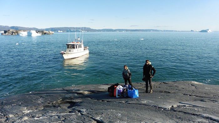
Here we were on the island, in the middle of nowhere, with all our luggage and food to organize, the tent to set up, and the kayaks to inflate—just 10 hours after leaving the Copenhagen hotel. We got to work, bothered by the flies. Despite our head nets, it was barely tolerable—there were so many of them. They swarmed by the dozens into every bag we opened. It was quite mild: 10°C.
Everything was ready by evening, and we were very happy to have completed all these transfers (planes and boat in a single day) as we slipped into our sleeping bags.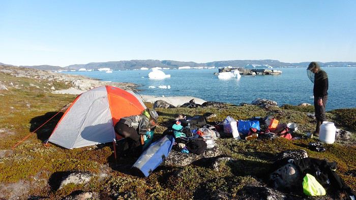
During the night, the wind picked up, and we went out several times to check the tent and kayak anchors. We noticed how bright it was—it was still quite twilight even at 1 AM.
Day 2 5:30 AM wake-up—the south wind was still strong, but since we were heading north, we decided to give it a try anyway.
This was also the moment we loaded the kayaks: since there were only three of us for two double-seater kayaks, we filled the hatch of one kayak, which allowed us to fit all our food. It would have been very difficult if there had been four of us for two kayaks.
Finally, we set off north along the western coast of the island. The conditions were far from ideal—the sea was rough, and the kayaks had a lot of wind resistance. But the main problem was the spray skirt: the gear on deck weighed it down, and the skirt kept coming off… We’d have to deal with it. Barely underway, and whales were already breaking the surface—it was our first time seeing them, and we were very impressed. Too bad the wind didn’t allow for longer contemplation; stopping paddling was impossible with such strong gusts.
We passed a few headlands and even considered stopping due to the conditions. To find some semblance of shelter, we had to hug the coast closely without cutting across the numerous bays, which significantly lengthened the journey. But as the morning went on, the wind died down, and the sea calmed. We spotted several whales and our first seals. It was almost pleasant during the picnic break. By late afternoon, we reached Kangerup Sarqâ Bay, where we had identified a great campsite with a very large beach and a river. But the wind had shifted—it was now coming from the north, making the last hour difficult due to fatigue and headwinds.
The campsite was ideal and beautiful, facing numerous icebergs grounded in the bay.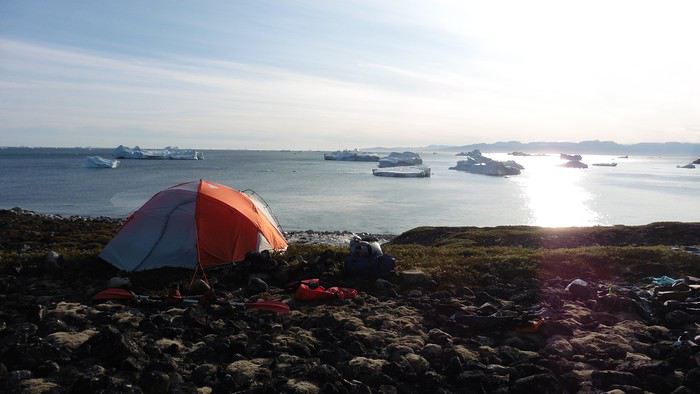
The GPS alerted us to another major drawback of inflatable kayaks: their slowness. It took us 7.5 hours of actual paddling (excluding breaks) to cover 28 km, averaging 3.7 km/h—somewhat disappointing. But we knew this before leaving, and once again, we’d have to make do!
Day 3 Surprise: at 6 AM wake-up, it was raining, foggy, with a south wind, and the sea was choppy even in the bay. It seemed wise to skip paddling, even though stopping on the second day was tough on morale. We went back to sleep, especially since the travel fatigue and the harsh conditions of the previous day had taken their toll.
At 11 AM, the navigation conditions weren’t any better—at the ends of the bay, we saw huge waves crashing onto the rocks, and giving up for the day became obvious. However, the rain had stopped, so we set off for a hike along the large lake bordering the bay. The wind hadn’t let up, and it was quite cold.
The tundra was starting to take on its autumn colors, and the contrast between the white lichens and the red vegetation was stunning. At the lake, we took out the fishing rods and quickly caught two beautiful Arctic char over 50 cm long.
As the afternoon wore on, the sun seemed closer. Along the beach, we gathered driftwood (mostly old planks) to cook our catch in foil over a fire. Eating our own food in such a beautiful place next to a good fire was comforting after the day’s setback.
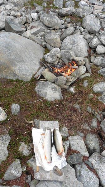
In the middle of the night, an Arctic fox entered the tent’s rear awning. It seemed barely intimidated when we shooed it away with loud shouts and then with stones.
Day 4 6:15 AM wake-up—3°C. We were on the water by 8 AM. The wind had dropped significantly, but the sea was shrouded in fog, and it was very cold in these damp conditions.
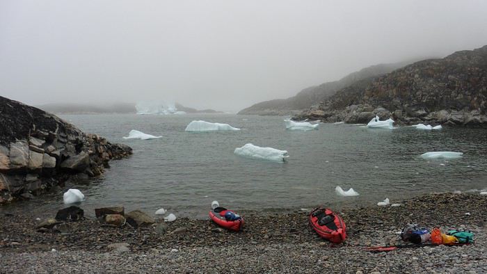
We passed the bay’s headland, Kangea, and headed toward the abandoned village of Agpat. The atmosphere was very austere—we hugged black rocks in fog that limited visibility to 50 meters, revealing large icebergs as we went.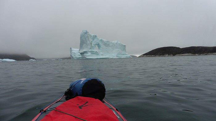
Suddenly, the water’s surface stirred in front of my kayak, and a huge gray back emerged from the sea. The collision was inevitable, but the whale seemed to understand and dove immediately, passing under the kayak and resurfacing a few meters away. I felt the kayak rock in the white foam and quickly paddled to escape the turbulence. What an emotion!
A light wind began to clear the fog, and the sun made beautiful appearances. Despite the cold, we stopped to visit the abandoned village, which left a strange impression. All the houses were still in good condition and wide open—some must have been very spacious in their time. We went back to sea, and in front of the large Kaangerdluk Bay, we hesitated—the headwind was strong, and large waves split the water. The next beach, from the island of Nua where we stopped to think, was over 8 km away. It was barely 2 PM, but caution led us to stop here for the day. We had covered 12 km—exactly the distance needed to stay on schedule. The afternoon was spent hiking on the island’s hills and gathering mussels and wood.
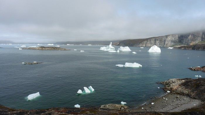
In the evening, we cooked these large Greenlandic mussels over a wood fire and savored them under the beautiful evening light. The weather was now fine, but the thermometer read -5°C in the sun…
Day 5 Bright sunshine, a glassy sea, and -8°C at 6 AM. Everything was green for setting off, even if putting on damp kayaking gear was a bit unpleasant in the cold. It was the first time we’d paddled on a flat sea since the start of the trip, and our average speed increased slightly.
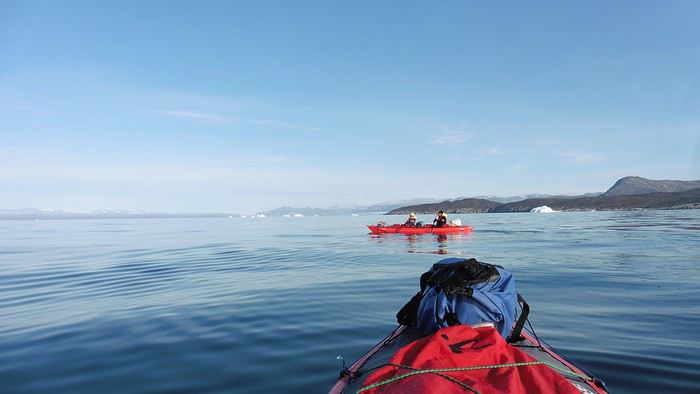
We entered the Smallesund Strait, marking the end of the island’s west coast. We were close to the large Torssukatak Fjord, where two glaciers flow. The access pass to the fjord was very narrow, and numerous ice chunks blocked access to the beaches. The wind had picked up and was now hitting us head-on (again). Just before entering the fjord, we landed on a steep beach made of large pebbles on Oqaitsut Island. It was very cold with the wind, and moving forward became difficult. We decided to stop for the day both because of the conditions and because the next campsite was far away, given how rugged the fjord was.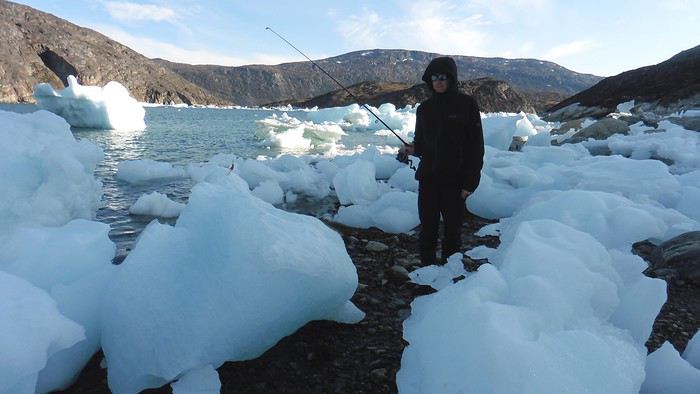
We eventually found a flat spot for the tent despite the steep slope. Even with the wind, the weather was beautiful, and we set off on foot for the northeastern cape of the island, overlooking the fjord. The view was far-reaching and exceptional—up close, the large fjord filled with ice and its steep granite cliffs, and in the distance, the ice cap and glacial walls.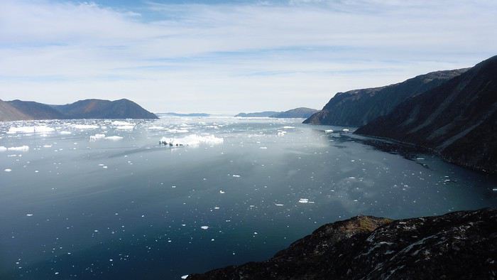
We spotted the village of Qeqertaq, whose network we could pick up, allowing us to check the weather forecast, which was rather good. While securing the kayaks in the evening, I noticed the strange behavior of one kayak at the end of the stage was due to the loss of the skeg—impossible to know where it detached. We’d have to do without it.
Day 6 Still that icy headwind from the northeast. We set off anyway for a long stage to reach the large pass connecting the Torssukatak and Ata Fjords.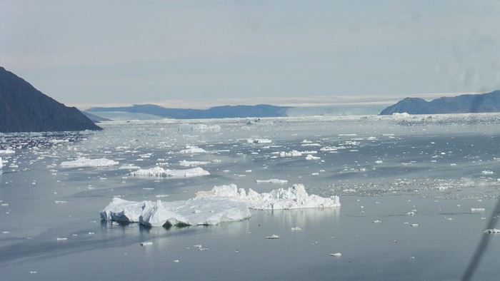
We advanced laboriously along the high cliffs of the fjord’s southern shore. They faced due north and blocked the sun. We felt the cold and dampness of the rock. It was really cold, especially in the extremities. We picnicked on the western cape of Qeqertakavasak Island. The cold didn’t allow us to stop for more than 20 minutes… But the wind dropped, and the sea was now very smooth. It was heavily cluttered with ice between the icebergs and old pack ice. The goal was to reach the large rocky promontory of Anapnuna, wedged between the Kujatdleq and Kangilerngata Glaciers, but the ice made progress difficult. We stopped to gain height on a small island and spot a passage of open water, but all we saw was white—passing seemed impossible. The currents were very complex, and entire sections of ice were being swept in one direction and then another at an impressive speed.
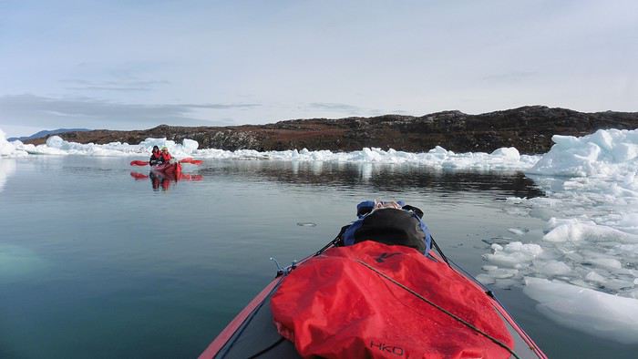
We wandered through this labyrinth until landing on a beach on the small island of Takissut, where we set up camp, exhausted from the 30 km covered and the vigilance required by the abundance of ice. The place was sublime under the evening sun—we were surrounded by ice and mountains, with the Kangilerngata Glacier in the distance. The summer contrasts were striking between the water, icebergs, sky, and flaming tundra—all colors were represented. Absolute calm reigned.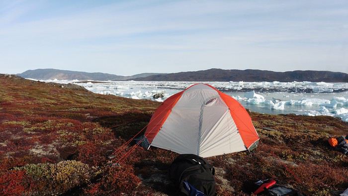
The lack of drinking water at this spot wasn’t too much of a constraint: as soon as we arrived on the beach, we placed containers under the icebergs stranded in the intertidal zone. They were all full by the time we finished setting up.
Day 7 We had to change our plans: we wouldn’t reach the rocky promontory, too well protected by the ice. We set off under the sun for Igdluluarssuit Island. Although we had spotted a passage just before launching, we quickly found ourselves surrounded by ice. It was everywhere, and finding water to paddle became complicated. We tried to force our way in every direction, even retracing our steps. Everything moved at an impressive speed—we were in the middle of a whirlpool of ice.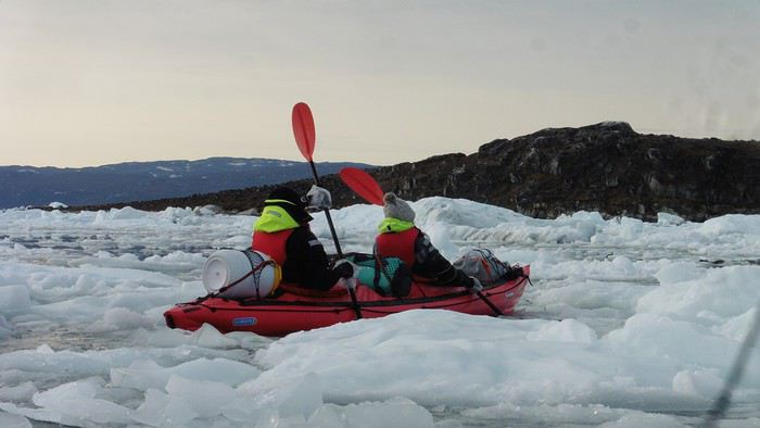
The tension rose, and each boat had its share of big scares. I was trapped against ice floes that dragged me toward an iceberg—the pressure on the kayak was enormous; it was going to capsize or puncture! But with a few strong strokes and paddling against the ice, I managed to free myself from the trap. Barely 10 minutes later, my companions were sandwiched perpendicularly between two icebergs that were closing in. The situation was desperate—the kayak was bending and twisting more and more, but with some strong paddle strokes, it finally freed itself. After these particularly unpleasant moments, we were completely blocked. The drifting ice floes had tightened, and the kayaks were no longer even in the water… The only solution: wait with the kayaks on these floes, which were too thin to walk on (even though we didn’t try). Within minutes, the situation cleared—a waterway opened, and we rushed into it. We paddled with one goal: find a larger pool of water. After going back and forth, our path took shape—we had to force the passage several times, attacking the ice directly with the kayaks, and finally, we escaped the worst of the labyrinth. We reached land on the west side of the island and saw that the rest would be easier. To reach the island, we just had to cross the Arsiviup Ikera Strait, which was lightly cluttered. We reached the eastern cape of the island, ideal for camping, even though we had only paddled for 3 hours. We set up camp and hiked to the island’s summit, which overlooks the entire pass and the glaciers.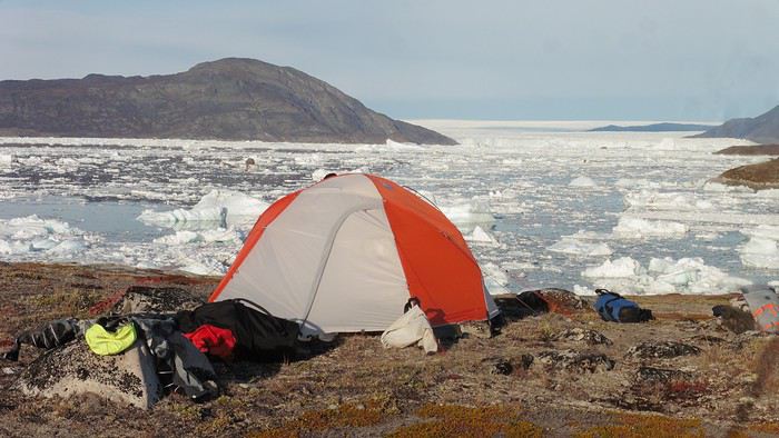
Everything was magnificent, no matter the direction. At 2 PM, we were at the summit—the beauty of the place and the picnic facing the glacier in the sun without wind made us forget the near-disaster from a few hours earlier. It would be impossible to approach the glacier by kayak, but from our summit on foot, it seemed so close, and contemplating it safely on solid ground was a great moment.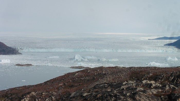
The pass was incredibly complex—everything was in motion, and an impassable passage could become open water within minutes. We were delighted when we returned to camp. A slightly lost whale among the ice accompanied us along the shore. The place was truly beautiful, but the temperature dropped again under the clear sky, preventing us from eating outside.
Day 8 Clear and cold at wake-up: -9°C. The sea had frozen in many places. We hesitated about the rest of the trip—should we start heading back to Ilulissat or linger in the pass, especially to approach the Eqi Glacier? After the incidents of the previous day, we decided to think carefully and paddled to the southern cape of our island to check the ice conditions toward Eqi. The weather had clouded over in the meantime, and the sky was quite gray. At the cape, we spotted the glacier’s wall, still 15 km away.
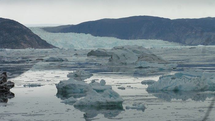
The fjord was quite cluttered, but it seemed passable. However, there was no guarantee the view would be much better 1 km from the glacier than 15 km away, especially since the front was quite active and therefore dangerous. We decided to head south without passing by the glacier. The cold temperatures encountered in the pass also motivated us to move away from the glaciers and the ice cap. We navigated under a threatening sky but without wind. The kayaks cut through the thin layer of ice on the surface with a crinkling paper sound. We reached the Ata campsite in the late afternoon after 5 hours of rowing without a single break…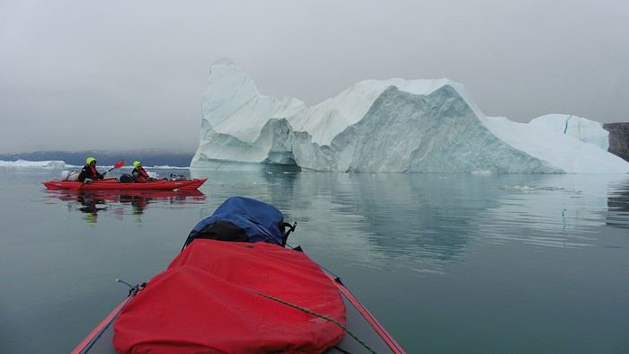
The wind had picked up, and we discovered a nice surprise: a refuge with a table and a comfortable bench lined with mattresses. Facing the worsening weather, we settled in comfortably. The kerosene stove was too complex for our three brains—we couldn’t get it started, too bad, as it was 0°C inside. The rest of the afternoon was spent fishing in the large lake, where we landed a beautiful Arctic char, more than enough for three. A good night’s sleep without the risk of foxes or the sound of a tent shaking in the wind.
Day 9 6 AM wake-up to the sound of rain hitting the cabin. The decision was made looking out the window—wind, rain, and fog obscured the sea: we went back to sleep.
New wake-up, and the rain had stopped—we could go out and stock up on fish. We set off on foot toward the lake, following its western shore. It was very overcast, and the wind encouraged us to keep moving. We made our way to a smaller lake at the end of the large one, where we caught a huge Arctic char. A small clearing brightened the picnic, and we headed back to our cabin.
This 20 km hike kept us busy all day: walking on slippery scree and the micro-relief of the peat bogs took time.
Day 10 The sky was clear, but a light south wind made paddling intense. We set off southeast to reach the opposite shore of the fjord. It was very cold, and it was impossible to stop paddling for even a moment without immediately losing ground due to the wind. We crossed the Kangerluarsuk Fjord. I recognized the cape I had reached on skis in the winter of 2017. We found a nice campsite on the southern shore of the fjord: Uiartag. It wasn’t even noon, but facing this headwind, we preferred to stop here rather than exhaust ourselves for a few extra kilometers. Like the previous ones, this campsite was very comfortable: the ground was covered with a thick layer of lichens and mosses, very pleasant to lie on.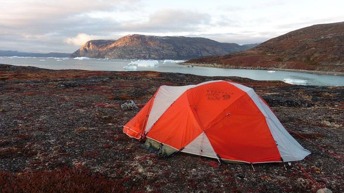
We set off on a hike to the heights of the cape, where the weather alternated between large clearings and snow showers. We noticed the loss of the thermometer, poorly attached to the backpack. On the way back, in the small bay of our beach, a whale swam calmly 10 meters from the shore—a beautiful surprise.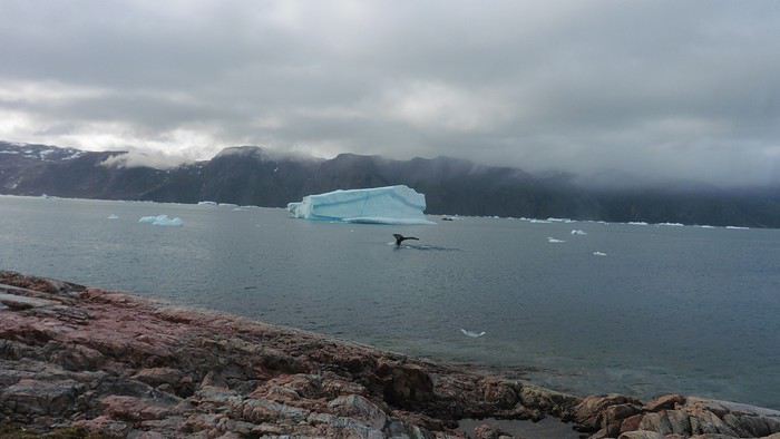
The sky cleared completely, and the temperature dropped as night approached.
We’re setting off as a group of three in two inflatable double-seater kayaks (Gumotex) brought from France. The plan is to spend two weeks circumnavigating Arve Princess Island, located north of Ilulissat in Disko Bay, with a possible boat drop-off at the southern tip of the island.
This seems like a fairly classic route in the area—we found several descriptions online (thanks to the authors). With their help and Google Earth, we identified all potential campsites and entered their coordinates into a GPS. The western part of the island, facing the bay, seems ideal for whale watching, while the more rugged eastern side offers access to several glacial walls. We’re somewhat familiar with the area from two winter expeditions on skis and pulkas.
Plus, the commitment is limited due to the island’s proximity to several small villages, including Qeqertaq, Oqaatsut, and even Ilulissat. In fact, we saw fishing boats almost every day. The distance suits us well: 200 kilometers in 16 full days on site, which should leave some leeway in case of bad weather or for hiking.
We booked our flights in June with Air Greenland to Ilulissat for the last week of August and the first week of September. On both the outbound and return trips, we stayed overnight in Copenhagen. The France-Copenhagen flight was with Air France.
We were allowed 3 x 20 kg in the hold. Each kayak with its accessories fits into a 20 kg bag; the last hold bag is for shared gear: tent, stoves, dry bags… We only brought 1.5 kg of semolina for food. In the end, we had 61 kg of gear, and no excess baggage was charged.
Individual gear (clothes and sleeping bags…) was distributed in the cabin luggage.
For the boat transfer, we contacted an agency: Blue Jay, which gave us a number to call upon arrival.
Day 0: Wednesday, August 22 Departure day. After work, I drove from Gap to Marseille’s Marignane Airport for the first leg of the trip to Copenhagen. I enjoyed the rather mild local temperatures: 35°C in the shade. After a layover in Paris, I arrived at the Copenhagen hotel, located two train stops from the airport, where my companions were already settled. No issues—everyone was on time with their luggage.
Day 1 The flight to Greenland was at 9 AM. We had a layover in Kangerlussuaq, where we changed planes, then stopped in Aasiaat before reaching Ilulissat Airport at 3 PM under beautiful sunshine.
We called Blue Jay for the boat transfer: they could take us to the island as early as 6 PM; otherwise, we’d have to wait until the next day. That left us 3 hours to prepare our gear and, most importantly, do our shopping for the two-week trip—it seemed tight, but we gave it a shot.
A quick taxi ride took us to Pisiffik, where we easily found everything we needed: bread, butter, cheese, cold cuts, rice, pasta, jam, muesli… There was no C fuel or methylated spirits for the stoves, but this time we knew the trick: at Stark, a bit uphill from the town, we found the precious liquids. Two hours later, we filled our dry bags and containers with our purchases, and by 5:30 PM, we met Klaus, the Blue Jay manager, directly at the port.
The vacation seemed to truly begin as we sped by boat through the icebergs toward Arve Princess Island. Forty-five minutes later, we spotted a beach lined with rocks where Klaus dropped us off quickly (he had another transfer to make right after).
Here we were on the island, in the middle of nowhere, with all our luggage and food to organize, the tent to set up, and the kayaks to inflate—just 10 hours after leaving the Copenhagen hotel. We got to work, bothered by the flies. Despite our head nets, it was barely tolerable—there were so many of them. They swarmed by the dozens into every bag we opened. It was quite mild: 10°C.
Everything was ready by evening, and we were very happy to have completed all these transfers (planes and boat in a single day) as we slipped into our sleeping bags.
During the night, the wind picked up, and we went out several times to check the tent and kayak anchors. We noticed how bright it was—it was still quite twilight even at 1 AM.
Day 2 5:30 AM wake-up—the south wind was still strong, but since we were heading north, we decided to give it a try anyway.
This was also the moment we loaded the kayaks: since there were only three of us for two double-seater kayaks, we filled the hatch of one kayak, which allowed us to fit all our food. It would have been very difficult if there had been four of us for two kayaks.
Finally, we set off north along the western coast of the island. The conditions were far from ideal—the sea was rough, and the kayaks had a lot of wind resistance. But the main problem was the spray skirt: the gear on deck weighed it down, and the skirt kept coming off… We’d have to deal with it. Barely underway, and whales were already breaking the surface—it was our first time seeing them, and we were very impressed. Too bad the wind didn’t allow for longer contemplation; stopping paddling was impossible with such strong gusts.
We passed a few headlands and even considered stopping due to the conditions. To find some semblance of shelter, we had to hug the coast closely without cutting across the numerous bays, which significantly lengthened the journey. But as the morning went on, the wind died down, and the sea calmed. We spotted several whales and our first seals. It was almost pleasant during the picnic break. By late afternoon, we reached Kangerup Sarqâ Bay, where we had identified a great campsite with a very large beach and a river. But the wind had shifted—it was now coming from the north, making the last hour difficult due to fatigue and headwinds.
The campsite was ideal and beautiful, facing numerous icebergs grounded in the bay.
The GPS alerted us to another major drawback of inflatable kayaks: their slowness. It took us 7.5 hours of actual paddling (excluding breaks) to cover 28 km, averaging 3.7 km/h—somewhat disappointing. But we knew this before leaving, and once again, we’d have to make do!
Day 3 Surprise: at 6 AM wake-up, it was raining, foggy, with a south wind, and the sea was choppy even in the bay. It seemed wise to skip paddling, even though stopping on the second day was tough on morale. We went back to sleep, especially since the travel fatigue and the harsh conditions of the previous day had taken their toll.
At 11 AM, the navigation conditions weren’t any better—at the ends of the bay, we saw huge waves crashing onto the rocks, and giving up for the day became obvious. However, the rain had stopped, so we set off for a hike along the large lake bordering the bay. The wind hadn’t let up, and it was quite cold.
The tundra was starting to take on its autumn colors, and the contrast between the white lichens and the red vegetation was stunning. At the lake, we took out the fishing rods and quickly caught two beautiful Arctic char over 50 cm long.
As the afternoon wore on, the sun seemed closer. Along the beach, we gathered driftwood (mostly old planks) to cook our catch in foil over a fire. Eating our own food in such a beautiful place next to a good fire was comforting after the day’s setback.
In the middle of the night, an Arctic fox entered the tent’s rear awning. It seemed barely intimidated when we shooed it away with loud shouts and then with stones.
Day 4 6:15 AM wake-up—3°C. We were on the water by 8 AM. The wind had dropped significantly, but the sea was shrouded in fog, and it was very cold in these damp conditions.
We passed the bay’s headland, Kangea, and headed toward the abandoned village of Agpat. The atmosphere was very austere—we hugged black rocks in fog that limited visibility to 50 meters, revealing large icebergs as we went.
Suddenly, the water’s surface stirred in front of my kayak, and a huge gray back emerged from the sea. The collision was inevitable, but the whale seemed to understand and dove immediately, passing under the kayak and resurfacing a few meters away. I felt the kayak rock in the white foam and quickly paddled to escape the turbulence. What an emotion!
A light wind began to clear the fog, and the sun made beautiful appearances. Despite the cold, we stopped to visit the abandoned village, which left a strange impression. All the houses were still in good condition and wide open—some must have been very spacious in their time. We went back to sea, and in front of the large Kaangerdluk Bay, we hesitated—the headwind was strong, and large waves split the water. The next beach, from the island of Nua where we stopped to think, was over 8 km away. It was barely 2 PM, but caution led us to stop here for the day. We had covered 12 km—exactly the distance needed to stay on schedule. The afternoon was spent hiking on the island’s hills and gathering mussels and wood.
In the evening, we cooked these large Greenlandic mussels over a wood fire and savored them under the beautiful evening light. The weather was now fine, but the thermometer read -5°C in the sun…
Day 5 Bright sunshine, a glassy sea, and -8°C at 6 AM. Everything was green for setting off, even if putting on damp kayaking gear was a bit unpleasant in the cold. It was the first time we’d paddled on a flat sea since the start of the trip, and our average speed increased slightly.
We entered the Smallesund Strait, marking the end of the island’s west coast. We were close to the large Torssukatak Fjord, where two glaciers flow. The access pass to the fjord was very narrow, and numerous ice chunks blocked access to the beaches. The wind had picked up and was now hitting us head-on (again). Just before entering the fjord, we landed on a steep beach made of large pebbles on Oqaitsut Island. It was very cold with the wind, and moving forward became difficult. We decided to stop for the day both because of the conditions and because the next campsite was far away, given how rugged the fjord was.
We eventually found a flat spot for the tent despite the steep slope. Even with the wind, the weather was beautiful, and we set off on foot for the northeastern cape of the island, overlooking the fjord. The view was far-reaching and exceptional—up close, the large fjord filled with ice and its steep granite cliffs, and in the distance, the ice cap and glacial walls.
We spotted the village of Qeqertaq, whose network we could pick up, allowing us to check the weather forecast, which was rather good. While securing the kayaks in the evening, I noticed the strange behavior of one kayak at the end of the stage was due to the loss of the skeg—impossible to know where it detached. We’d have to do without it.
Day 6 Still that icy headwind from the northeast. We set off anyway for a long stage to reach the large pass connecting the Torssukatak and Ata Fjords.
We advanced laboriously along the high cliffs of the fjord’s southern shore. They faced due north and blocked the sun. We felt the cold and dampness of the rock. It was really cold, especially in the extremities. We picnicked on the western cape of Qeqertakavasak Island. The cold didn’t allow us to stop for more than 20 minutes… But the wind dropped, and the sea was now very smooth. It was heavily cluttered with ice between the icebergs and old pack ice. The goal was to reach the large rocky promontory of Anapnuna, wedged between the Kujatdleq and Kangilerngata Glaciers, but the ice made progress difficult. We stopped to gain height on a small island and spot a passage of open water, but all we saw was white—passing seemed impossible. The currents were very complex, and entire sections of ice were being swept in one direction and then another at an impressive speed.
We wandered through this labyrinth until landing on a beach on the small island of Takissut, where we set up camp, exhausted from the 30 km covered and the vigilance required by the abundance of ice. The place was sublime under the evening sun—we were surrounded by ice and mountains, with the Kangilerngata Glacier in the distance. The summer contrasts were striking between the water, icebergs, sky, and flaming tundra—all colors were represented. Absolute calm reigned.
The lack of drinking water at this spot wasn’t too much of a constraint: as soon as we arrived on the beach, we placed containers under the icebergs stranded in the intertidal zone. They were all full by the time we finished setting up.
Day 7 We had to change our plans: we wouldn’t reach the rocky promontory, too well protected by the ice. We set off under the sun for Igdluluarssuit Island. Although we had spotted a passage just before launching, we quickly found ourselves surrounded by ice. It was everywhere, and finding water to paddle became complicated. We tried to force our way in every direction, even retracing our steps. Everything moved at an impressive speed—we were in the middle of a whirlpool of ice.
The tension rose, and each boat had its share of big scares. I was trapped against ice floes that dragged me toward an iceberg—the pressure on the kayak was enormous; it was going to capsize or puncture! But with a few strong strokes and paddling against the ice, I managed to free myself from the trap. Barely 10 minutes later, my companions were sandwiched perpendicularly between two icebergs that were closing in. The situation was desperate—the kayak was bending and twisting more and more, but with some strong paddle strokes, it finally freed itself. After these particularly unpleasant moments, we were completely blocked. The drifting ice floes had tightened, and the kayaks were no longer even in the water… The only solution: wait with the kayaks on these floes, which were too thin to walk on (even though we didn’t try). Within minutes, the situation cleared—a waterway opened, and we rushed into it. We paddled with one goal: find a larger pool of water. After going back and forth, our path took shape—we had to force the passage several times, attacking the ice directly with the kayaks, and finally, we escaped the worst of the labyrinth. We reached land on the west side of the island and saw that the rest would be easier. To reach the island, we just had to cross the Arsiviup Ikera Strait, which was lightly cluttered. We reached the eastern cape of the island, ideal for camping, even though we had only paddled for 3 hours. We set up camp and hiked to the island’s summit, which overlooks the entire pass and the glaciers.
Everything was magnificent, no matter the direction. At 2 PM, we were at the summit—the beauty of the place and the picnic facing the glacier in the sun without wind made us forget the near-disaster from a few hours earlier. It would be impossible to approach the glacier by kayak, but from our summit on foot, it seemed so close, and contemplating it safely on solid ground was a great moment.
The pass was incredibly complex—everything was in motion, and an impassable passage could become open water within minutes. We were delighted when we returned to camp. A slightly lost whale among the ice accompanied us along the shore. The place was truly beautiful, but the temperature dropped again under the clear sky, preventing us from eating outside.
Day 8 Clear and cold at wake-up: -9°C. The sea had frozen in many places. We hesitated about the rest of the trip—should we start heading back to Ilulissat or linger in the pass, especially to approach the Eqi Glacier? After the incidents of the previous day, we decided to think carefully and paddled to the southern cape of our island to check the ice conditions toward Eqi. The weather had clouded over in the meantime, and the sky was quite gray. At the cape, we spotted the glacier’s wall, still 15 km away.
The fjord was quite cluttered, but it seemed passable. However, there was no guarantee the view would be much better 1 km from the glacier than 15 km away, especially since the front was quite active and therefore dangerous. We decided to head south without passing by the glacier. The cold temperatures encountered in the pass also motivated us to move away from the glaciers and the ice cap. We navigated under a threatening sky but without wind. The kayaks cut through the thin layer of ice on the surface with a crinkling paper sound. We reached the Ata campsite in the late afternoon after 5 hours of rowing without a single break…
The wind had picked up, and we discovered a nice surprise: a refuge with a table and a comfortable bench lined with mattresses. Facing the worsening weather, we settled in comfortably. The kerosene stove was too complex for our three brains—we couldn’t get it started, too bad, as it was 0°C inside. The rest of the afternoon was spent fishing in the large lake, where we landed a beautiful Arctic char, more than enough for three. A good night’s sleep without the risk of foxes or the sound of a tent shaking in the wind.
Day 9 6 AM wake-up to the sound of rain hitting the cabin. The decision was made looking out the window—wind, rain, and fog obscured the sea: we went back to sleep.
New wake-up, and the rain had stopped—we could go out and stock up on fish. We set off on foot toward the lake, following its western shore. It was very overcast, and the wind encouraged us to keep moving. We made our way to a smaller lake at the end of the large one, where we caught a huge Arctic char. A small clearing brightened the picnic, and we headed back to our cabin.
This 20 km hike kept us busy all day: walking on slippery scree and the micro-relief of the peat bogs took time.
Day 10 The sky was clear, but a light south wind made paddling intense. We set off southeast to reach the opposite shore of the fjord. It was very cold, and it was impossible to stop paddling for even a moment without immediately losing ground due to the wind. We crossed the Kangerluarsuk Fjord. I recognized the cape I had reached on skis in the winter of 2017. We found a nice campsite on the southern shore of the fjord: Uiartag. It wasn’t even noon, but facing this headwind, we preferred to stop here rather than exhaust ourselves for a few extra kilometers. Like the previous ones, this campsite was very comfortable: the ground was covered with a thick layer of lichens and mosses, very pleasant to lie on.
We set off on a hike to the heights of the cape, where the weather alternated between large clearings and snow showers. We noticed the loss of the thermometer, poorly attached to the backpack. On the way back, in the small bay of our beach, a whale swam calmly 10 meters from the shore—a beautiful surprise.
The sky cleared completely, and the temperature dropped as night approached.
Séjour multi-activités à Québec en décembre English translation pending
Bonjour,
je prépare notre séjour à Québec pour Décembre 2018 les billets d'avion sont déjà achetés objectif recherché : trouver un hébergement le plus près possible de la ville de Québec (notre fils y travaille) qui nous proposerait du "tout inclus" c'est à dire : - aller nous chercher à l'aéroport de Montréal et nous ramener pour notre retour (nous ne pensons pas louer de voiture) - nous proposer des activités de chiens de traîneaux, moto-neige, cabane à sucre (je connais en été mais pas en hiver), raquettes, match de hockey, bref toute activité pouvant se proposer en hiver, sauf le ski - nous proposer la formule 1/2 pension ou pension complète. j'oubliais : nous serons 3 ou 4 suivant la présente ou nom de mon fils
j'ai bien sur commencé à chercher mais tout ce que je trouve est du côté de Montréal existe-t-il des gîtes qui ont font ce genre de formule ? cela nous permettrait de rencontrer des gens et partager avec eux, contrairement à la formule hôtel. si vous avez des idées, des contacts, merci d'avance !
je prépare notre séjour à Québec pour Décembre 2018 les billets d'avion sont déjà achetés objectif recherché : trouver un hébergement le plus près possible de la ville de Québec (notre fils y travaille) qui nous proposerait du "tout inclus" c'est à dire : - aller nous chercher à l'aéroport de Montréal et nous ramener pour notre retour (nous ne pensons pas louer de voiture) - nous proposer des activités de chiens de traîneaux, moto-neige, cabane à sucre (je connais en été mais pas en hiver), raquettes, match de hockey, bref toute activité pouvant se proposer en hiver, sauf le ski - nous proposer la formule 1/2 pension ou pension complète. j'oubliais : nous serons 3 ou 4 suivant la présente ou nom de mon fils
j'ai bien sur commencé à chercher mais tout ce que je trouve est du côté de Montréal existe-t-il des gîtes qui ont font ce genre de formule ? cela nous permettrait de rencontrer des gens et partager avec eux, contrairement à la formule hôtel. si vous avez des idées, des contacts, merci d'avance !
Randonnée raquettes entre amis English translation pending
Bonjour,
Nous sommes un petit groupe d'amis (6 pers) et nous recherchons notre prochain séjour hivernal pour une semaine de randonnée à raquettes. Nous souhaitons partir hors-saison fin janvier début février 2019.
Nous avons cherché dans le Jura (Les Rousses/Lamoura) mais cela semble au delà de notre hors budget (500 euros/pers, hébergement en demi-pension).
Nous élargissons nos recherches à l'Auvergne et aux Alpes, mais ne trouvons pas notre bonheur.
Est-ce que vous avez des références de gîtes ou hôtel en demi-pension dans le Jura ou en Auvergne ?
Nous sommes un petit groupe d'amis (6 pers) et nous recherchons notre prochain séjour hivernal pour une semaine de randonnée à raquettes. Nous souhaitons partir hors-saison fin janvier début février 2019.
Nous avons cherché dans le Jura (Les Rousses/Lamoura) mais cela semble au delà de notre hors budget (500 euros/pers, hébergement en demi-pension).
Nous élargissons nos recherches à l'Auvergne et aux Alpes, mais ne trouvons pas notre bonheur.
Est-ce que vous avez des références de gîtes ou hôtel en demi-pension dans le Jura ou en Auvergne ?
PVT Argentine: Bariloche et sa beauté naturelle en 2 minutes 20 (vidéo) English translation pending
Cela fait 6 mois que je voyage en Argentine avec une amie et notre séjour a commencé en début d'année. Après le passage obligé par la capitale Buenos Aires, nous avons pris la direction de la Patagonie et sa nature éblouissante !! Nous avons commencé par le nord de la Patagonie avec San Carlos de Bariloche. Sa nature, ses montagnes et ses lacs nous ont fait succomber.
La ville est connue pour son chocolat, mais aussi pour sa célèbre station de ski en hiver, Cerro Catedral, et pour ses sentiers de randonnées en été. Plusieurs points qui font qu’on la surnomme parfois la petite suisse des Andes. Bariloche est une ville charmante sur les bords du lac Nahuel Huapi, en plein cœur du Parc National Nahuel Huapi. Nous y avons passé une semaine et nous avons beaucoup apprécié notre séjour même si nous y étions en pleine saison touristique. Pour ceux qui aime la nature, les randonnées et la montagne, vous serez servi ! Pour vous donner un avant goût de ce que vous pourriez découvrir à Bariloche, mon amie et moi avons fait une vidéo de 2min20, top chrono, pour vous mettre l'eau à la bouche sans pour autant tout vous dévoiler. 😉 Dites moi ce que vous en pensez. Et si vous avez déjà eu la chance de passer par cette ville, ou même peut être d’y vivre, je serais ravie d'avoir votre ressenti !
https://www.youtube.com/watch?v=-VkrgN4V4GU&t=10s
La ville est connue pour son chocolat, mais aussi pour sa célèbre station de ski en hiver, Cerro Catedral, et pour ses sentiers de randonnées en été. Plusieurs points qui font qu’on la surnomme parfois la petite suisse des Andes. Bariloche est une ville charmante sur les bords du lac Nahuel Huapi, en plein cœur du Parc National Nahuel Huapi. Nous y avons passé une semaine et nous avons beaucoup apprécié notre séjour même si nous y étions en pleine saison touristique. Pour ceux qui aime la nature, les randonnées et la montagne, vous serez servi ! Pour vous donner un avant goût de ce que vous pourriez découvrir à Bariloche, mon amie et moi avons fait une vidéo de 2min20, top chrono, pour vous mettre l'eau à la bouche sans pour autant tout vous dévoiler. 😉 Dites moi ce que vous en pensez. Et si vous avez déjà eu la chance de passer par cette ville, ou même peut être d’y vivre, je serais ravie d'avoir votre ressenti !
https://www.youtube.com/watch?v=-VkrgN4V4GU&t=10s
Skier au Chili English translation pending
Bonjour à tous,
Je viens a la pêche aux informations pour aller skier au Chili.
Je prévois de partir du 14 Juillet au 23 Juillet 2018 pour Santiago du Chili et ensuite louer un véhicule direction Valle Nevado / La Parva / El colorado.
J'ai réservé dans un petit B&B dans les montagnes à 30mn de routes de chacun de ces "domaines".
Voici mes interrogations:
- Je vais réserver un véhicule à l'aéroport de Santiago. L'état des routes est-il correct dans les montagnes? Pour savoir s'il est vraiment nécessaire de prendre les assurances pour pneumatiques et autres.
- Il m'a sembler lire aussi que l'accès aux routes de montagnes était interdit si les véhicules n'avait pas les équipements nécessaire (chaines). mais les locataires de véhicules n'ont pas l'air d'avoir cette option de location est-il possible de s'en procurer autres part?
- Les stationnements pendant la journée ski aux stations citées précédemment, sont-ils accessibles, gratuits ou payants?
- Avez vous des contacts de guide de haute montagne pour des sorties hors des sentiers battus?
- Et je suis preneur si vous avez des bons plans ou autres.
Merci d'avance.
Je viens a la pêche aux informations pour aller skier au Chili.
Je prévois de partir du 14 Juillet au 23 Juillet 2018 pour Santiago du Chili et ensuite louer un véhicule direction Valle Nevado / La Parva / El colorado.
J'ai réservé dans un petit B&B dans les montagnes à 30mn de routes de chacun de ces "domaines".
Voici mes interrogations:
- Je vais réserver un véhicule à l'aéroport de Santiago. L'état des routes est-il correct dans les montagnes? Pour savoir s'il est vraiment nécessaire de prendre les assurances pour pneumatiques et autres.
- Il m'a sembler lire aussi que l'accès aux routes de montagnes était interdit si les véhicules n'avait pas les équipements nécessaire (chaines). mais les locataires de véhicules n'ont pas l'air d'avoir cette option de location est-il possible de s'en procurer autres part?
- Les stationnements pendant la journée ski aux stations citées précédemment, sont-ils accessibles, gratuits ou payants?
- Avez vous des contacts de guide de haute montagne pour des sorties hors des sentiers battus?
- Et je suis preneur si vous avez des bons plans ou autres.
Merci d'avance.
Itinéraire 3 mois Argentine et Chili English translation pending
Bonjour,
Je suis actuellement en Bolivie. Je vais pouvoir voyager au Chili et en Argentine, en partant de la ville de Sucre (Bolivie), pour une durée de 3 mois. Mon billet de retour, pour revenir en France, est à Sucre, en Bolivie. C'est pourquoi je fais appel à vous pour des conseils d'itinéraires au Chili et en Argentine, sur une période de trois mois.
Pour profiter plus longtemps de mon périple, et pour éviter un fastidieux retour en bus pour rejoindre la Bolivie, je songe à prendre un avion à Buenos Aires ou à Santiago, pour revenir à Sucre, pour pouvoir prendre mon billet d'avion vers la France.
Pensez-vous que je peux avoir le temps de descendre en Patagonie et de revenir en Bolivie ensuite ? Quels sont les endroits que vous recommandez de visiter au Chili, en Argentine et même en Uruguay ? Quels sont les itinéraires que vous me suggérez pour une période de 3 mois de voyage ?
Je vous remercie d'avance.
Je vous souhaite de beaux voyages à toutes et tous !
Je suis actuellement en Bolivie. Je vais pouvoir voyager au Chili et en Argentine, en partant de la ville de Sucre (Bolivie), pour une durée de 3 mois. Mon billet de retour, pour revenir en France, est à Sucre, en Bolivie. C'est pourquoi je fais appel à vous pour des conseils d'itinéraires au Chili et en Argentine, sur une période de trois mois.
Pour profiter plus longtemps de mon périple, et pour éviter un fastidieux retour en bus pour rejoindre la Bolivie, je songe à prendre un avion à Buenos Aires ou à Santiago, pour revenir à Sucre, pour pouvoir prendre mon billet d'avion vers la France.
Pensez-vous que je peux avoir le temps de descendre en Patagonie et de revenir en Bolivie ensuite ? Quels sont les endroits que vous recommandez de visiter au Chili, en Argentine et même en Uruguay ? Quels sont les itinéraires que vous me suggérez pour une période de 3 mois de voyage ?
Je vous remercie d'avance.
Je vous souhaite de beaux voyages à toutes et tous !
Aéroport de Lyon, terminal T1B English translation pending
Un an est passé depuis ma première utilisation et je viens a nouveau d'utiliser le terminal T1B ; le constat reste inchangé !
Pour l'aller nous avons du attendre la désignation de la porte d'embarquement dans une sorte de hangar situé au milieu des pistes , accessible par un souterrain et sans aucun service digne de ce nom (un distributeur de boisson et des toilettes) les boutiques existent mais sont toutes fermées.
Au retour, atterrissage 23h10(merci Transavia pour les 10 mn d'avace), il aura fallu plus d'une heure pour délivrer nos bagages ; il faudra 40 minutes pour que la navette parking (à priori unique à cette heure) réussisse à nous emmeer à notre parking.
Je me garderai de rappeler le marathon intérieur à effectuer dans l'aéroport, l'inefficience des contrôles bagages et aux frontières ; je n’évoquerai pas la signalétique désastreuse des départs de navettes, ni la géolocalisation de celles-ci également en panne ; heureusement qu'il existe de la solidarité entre voyageurs et des personnes habituées des lieux.
Stop dans le Vermont + itinéraire au Québec en transport en commun English translation pending
Bonjour
Nous serons 2 adultes et un enfant. Nous souhaiterions passer 2 nuits dans le Vermont.
Nous devrions a priori arriver en voiture depuis Boston sauf s'il est simple de s'y rendre en bus ou train. Si nous arrivons en voiture nous souhaiterions rendre la voiture aux Etats Unis.
Nous aimerions visiter un endroit avec de beaux paysages puis ensuite nous rendre dans la ville de Quebec par train ou bus.
Auriez vous un conseil de stop dans le Vermont et m'indiquer comment on peut se rendre à Quebec? Merci
Nous devrions a priori arriver en voiture depuis Boston sauf s'il est simple de s'y rendre en bus ou train. Si nous arrivons en voiture nous souhaiterions rendre la voiture aux Etats Unis.
Nous aimerions visiter un endroit avec de beaux paysages puis ensuite nous rendre dans la ville de Quebec par train ou bus.
Auriez vous un conseil de stop dans le Vermont et m'indiquer comment on peut se rendre à Quebec? Merci
Road trip Grand Canyon - Lake Powell - Monument Valley - Zion English translation pending
Bonjour à tous :)
J'ai besoin de quelques conseils...
Road trip aux USA en AOUT 2018. Je souhaiterai savoir si il est suffisant et judicieux de consacrer 5 jours ( voir 6 jours max) pour faire GRAND CANYON - MONUMENT VALLEY - LAKE POWELL - ZION ?
1 - Où Dormir ? (Hôtel pour Monument Valley ? - Hôtel pour ZION ?) 2 - Combien de temps consacrer à chaque parc en sachant que nous avons uniquement 5 Jours voir 6 possible ? 3 - Notre Priorité est Grand Canyon - Lake Powell - Monument Valley - Zion, est-ce judicieux ? 4 - Faut-il acheter pass pour parc ? si Oui, que me conseillez-vous ? 5 - Hélicoptère ou Jet Ski Lake Powell ? Avez-vous des infos à me communiquer et conseils ? 6 - Location voiture Las Vegas, pour commencer par Grand Canyon et remonter LAKE POWELL - MONUMENT VALLEY - ZION - LAS VEGAS ? Judicieux ?
Je vous remercie par avance de votre aide :)
J'ai besoin de quelques conseils...
Road trip aux USA en AOUT 2018. Je souhaiterai savoir si il est suffisant et judicieux de consacrer 5 jours ( voir 6 jours max) pour faire GRAND CANYON - MONUMENT VALLEY - LAKE POWELL - ZION ?
1 - Où Dormir ? (Hôtel pour Monument Valley ? - Hôtel pour ZION ?) 2 - Combien de temps consacrer à chaque parc en sachant que nous avons uniquement 5 Jours voir 6 possible ? 3 - Notre Priorité est Grand Canyon - Lake Powell - Monument Valley - Zion, est-ce judicieux ? 4 - Faut-il acheter pass pour parc ? si Oui, que me conseillez-vous ? 5 - Hélicoptère ou Jet Ski Lake Powell ? Avez-vous des infos à me communiquer et conseils ? 6 - Location voiture Las Vegas, pour commencer par Grand Canyon et remonter LAKE POWELL - MONUMENT VALLEY - ZION - LAS VEGAS ? Judicieux ?
Je vous remercie par avance de votre aide :)
Road trip de 22 jours en Californie et dans l'Ouest américain English translation pending
Bonjour, j'avais demandé pas mal d'avis pour préparer mon Road Trip, le voilà bouclé. 🙂
Je vous l'expose et j'attends vos éventuels retours et conseils afin d'optimiser au mieux .
Merci à tous. 😉
J1- arrivée dans la soirée à SFO - J2 libre SFO nuit SFO J3 libre SFO nuit SFO J4 vol pour salt lake city (nuit à thayne) J5 grand téton park + début yellowstone (nuit à Lake yellowstone) J6- yellowstone (nuit à mamoth) J7 Yellowstone (nuit à West yellowstone) J8 yellowstone (nuit à West yellowstone) J9 route jusqu'à provo (via antelope island) (nuit à provo) J10 Bryce canyon (nuit à bryce) J11 ZION - page (nuit à page) J12 jounée lac powell (jet ski) horseshoe bend (nuit page) J13 LOWER antelope canyon + départ pour M. VAlley - valley drive en fin de journée (nuit M. V) J14 petit tour à M. V et le goulding's muséum puis route vers G. CANYON (avec les points de vus) nuit à G. Canyon J15 journée à G. canyon J16- route vers las vegas en empruntant un peu de la route 66 - nuit à LV J17 - las vegas, repos, piscine ... nuit à LV. J18 Départ pour LA J19 visite des studions universal J20- Sortie en mer pour observer les balleines + Santa monica + B. Hills J21- Visite des Studios WB + mme TUSSAUD et bien sur walk of fame J22 libre jusqu'à 14h (vol à 17h)
J1- arrivée dans la soirée à SFO - J2 libre SFO nuit SFO J3 libre SFO nuit SFO J4 vol pour salt lake city (nuit à thayne) J5 grand téton park + début yellowstone (nuit à Lake yellowstone) J6- yellowstone (nuit à mamoth) J7 Yellowstone (nuit à West yellowstone) J8 yellowstone (nuit à West yellowstone) J9 route jusqu'à provo (via antelope island) (nuit à provo) J10 Bryce canyon (nuit à bryce) J11 ZION - page (nuit à page) J12 jounée lac powell (jet ski) horseshoe bend (nuit page) J13 LOWER antelope canyon + départ pour M. VAlley - valley drive en fin de journée (nuit M. V) J14 petit tour à M. V et le goulding's muséum puis route vers G. CANYON (avec les points de vus) nuit à G. Canyon J15 journée à G. canyon J16- route vers las vegas en empruntant un peu de la route 66 - nuit à LV J17 - las vegas, repos, piscine ... nuit à LV. J18 Départ pour LA J19 visite des studions universal J20- Sortie en mer pour observer les balleines + Santa monica + B. Hills J21- Visite des Studios WB + mme TUSSAUD et bien sur walk of fame J22 libre jusqu'à 14h (vol à 17h)
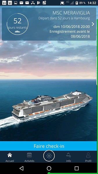
Croisière MSC Meraviglia Hambourg - Spitzberg du 10 juin 2018 English translation pending
Bonjour ,
Bientôt, mais pas beaucoup de Français j'ai l'impression?
Alaska, Laponie ou Groenland pour femme en voyage organisé English translation pending
Partir seule ne me conviendrait pas. Mais je déplore les suppléments chambres individuelles parfois très élevé (ce qui fait renoncer à la destination envisagée) un voyage organisé avec un petit nombre de participants me convient parfaitement. Je reviens d'un circuit de 2400 km au Mexique et cherche où aller du 20 ou 22 décembre jusqu'au 3 ou 4 janvier. Chaud Froid, qui a fait l'Alaska, la Laponie ou le Groenland. Quelques avis s'il vous plait
Petrohué - Lago Todos los Santos - volcan Osorno (Chili) English translation pending
Bonjour à toutes et tous,
Bientôt en visite dans la région des lacs, entre l'Argentine et le Chili, nous suivrons les conseils glanés sur le forum et ne ferons pas le "Cruce de lagos" commercial. Je suis à la recherches d'infos pour profiter au mieux de la région, et plus précisément :
* comment rejoindre Petrohué ? Il y a un bus de Bariloche à Puerto Varas, qui s'arrête je crois à Osorno. S'arrête-t-il aussi à Ensenada ? Et les mini-bus qui vont de Puerto Varas à Petrohué s'arrêtent-ils eux aussi à Ensenada ? Ça nous éviterait d'aller jusqu'à Puerto Varas (nous voyageons avec des enfants, et 2h de gagné c'est toujours ça 🤪!).
* Est-il judicieux de loger à Petrohué ? mon idée est de faire un tour sur le lac (a priori jusqu'à Peulla, mais s'il y a d'autres options ça m'intéresse... j'ai cru voir un plan de bateau de pêcheur vers Marguerita ??), mais aussi peut-être un bout de la balade Paso de la desolacion, voire monter jusqu'à la station de ski du volcan Osorno (je l'ai vu mentionnée mais je ne sais pas vraiment comment on y accède ou son intérêt à l'automne... nous y serons début mai).
Toute info sur la micro-région autour de Petrohué m'intéresse. A priori nous n'irons pas beaucoup plus loin (à moins que vous m'indiquiez qu'il vaut mieux avoir une autre base). Ça sera juste une parenthèse de 4 jours depuis Bariloche (en incluant les trajets).
Un grand merci à vous,
Tilde.
Bientôt en visite dans la région des lacs, entre l'Argentine et le Chili, nous suivrons les conseils glanés sur le forum et ne ferons pas le "Cruce de lagos" commercial. Je suis à la recherches d'infos pour profiter au mieux de la région, et plus précisément :
* comment rejoindre Petrohué ? Il y a un bus de Bariloche à Puerto Varas, qui s'arrête je crois à Osorno. S'arrête-t-il aussi à Ensenada ? Et les mini-bus qui vont de Puerto Varas à Petrohué s'arrêtent-ils eux aussi à Ensenada ? Ça nous éviterait d'aller jusqu'à Puerto Varas (nous voyageons avec des enfants, et 2h de gagné c'est toujours ça 🤪!).
* Est-il judicieux de loger à Petrohué ? mon idée est de faire un tour sur le lac (a priori jusqu'à Peulla, mais s'il y a d'autres options ça m'intéresse... j'ai cru voir un plan de bateau de pêcheur vers Marguerita ??), mais aussi peut-être un bout de la balade Paso de la desolacion, voire monter jusqu'à la station de ski du volcan Osorno (je l'ai vu mentionnée mais je ne sais pas vraiment comment on y accède ou son intérêt à l'automne... nous y serons début mai).
Toute info sur la micro-région autour de Petrohué m'intéresse. A priori nous n'irons pas beaucoup plus loin (à moins que vous m'indiquiez qu'il vaut mieux avoir une autre base). Ça sera juste une parenthèse de 4 jours depuis Bariloche (en incluant les trajets).
Un grand merci à vous,
Tilde.
Randonnées et treks en Patagonie en juillet 2018 English translation pending
bonjour ,
je compte faire des randonnées et trek en patagonie en juillet et début aout ...
je voudrais avoir des conseils sur des endroits ou parcs a visiter a cette période ...
je voudrais notamment faire le parc torres del paine mais il parait que durant l'hiver austral il faut prendre un guide? et comme je voyage seul je ne peux pas me permettre un guide a 150 euros la journée ...dans ce cas de figure est ce que el chalten en argentine ne serait pas plus indiqué ?
derniére chose est ce qu'il y a moyen de faire des randonnée ou trek du coté de puerto williams?
merci a vous ...🙂
Dubai, family vacation
After the wide-open spaces of the American West, we're off to a new destination: Dubai. Not just for a layover, but for a real family vacation!! The question that kept coming up was "why Dubai?" (after why Colorado this summer, people are going to think we're really weird 😅). So, why Dubai? First, because skiing isn’t really our thing anymore—so in winter, we want sunshine 😎. But not just any sunshine—warm enough to swim, which narrows things down a bit 😅. The second constraint this year: Franck can’t take more than a week off (and it’s unpaid), so we’re ruling out destinations with 12-hour flights and jet lag that knocks you out when you get back 😅. The options are getting tighter… So, against all odds, it’s me who ends up suggesting Dubai (my husband’s been nagging me for years about Atlantis and its mega water park—ah, the kids! 😉).
Actually, Dubai only has 2 days of rain a year (you’d have to be *really* unlucky!!), temperatures around 30°C in winter, the sea (oh yeah, I forgot—the sea was something we missed this summer, so it was on our list 😅), a 6/7-hour flight, just 3 hours of jet lag, reasonable family prices, and tons of activities for all tastes. Starting my research with a pretty negative bias, I’m now looking forward to this trip with excitement and impatience… and without spoiling the ending, I won’t be disappointed—our whole family will come back enthusiastic and ready to go back!!
So, I’m taking you along for a week in Dubai at the beginning of March.
Actually, Dubai only has 2 days of rain a year (you’d have to be *really* unlucky!!), temperatures around 30°C in winter, the sea (oh yeah, I forgot—the sea was something we missed this summer, so it was on our list 😅), a 6/7-hour flight, just 3 hours of jet lag, reasonable family prices, and tons of activities for all tastes. Starting my research with a pretty negative bias, I’m now looking forward to this trip with excitement and impatience… and without spoiling the ending, I won’t be disappointed—our whole family will come back enthusiastic and ready to go back!!
So, I’m taking you along for a week in Dubai at the beginning of March.
Itinéraire Vancouver - Victoria - Whistler? English translation pending
Bonjour,
Au début juin 2018, nous partirons pour 9 jours visiter Vancouver, l'Île de Vancouver et Whistler. Je ne sais pas comment organiser mon itinéraire. Combien de jours devrais-je prioriser à Vancouver et Victoria? Devrions-nous dormir une nuit près de Whistler pour explorer ce coin plus en profondeur? Où devrions-nous prioriser nos dodos???
Merci!!!
Séjourner l'hiver au Canada English translation pending
Ma fille devant partir pour plusieurs mois l'hiver prochain à Montréal, j'aimerai avoir des infos sur
- la manière de s'habiller : les différentes couches de vêtements, avec des noms de marque grand froid efficaces pour affronter ces températures.
- Quelles démarches pour passer la frontière Canada vers les USA.
Merci pour vos réponses.
Gravir le Mont Blanc en juin English translation pending
Bonsoir ! On est deux montagnards qui avons l'intention de partir gravir le mont blanc mi juin de cette année et en regardant les réservations du refuge au Goûter tout est déjà complet. On sait qu'on peut réserver également au refuge de tête rousse mais en essayant de réserver ça ne donne rien. Auriez vous des conseils ou informations à fournir à ce sujet ? Est ce qu'on s'y prends vraiment trop tard ? Merci beaucoup par avance dès vos réponses.
Oihana et Olivier
Oihana et Olivier
Antelope Canyon et Lake Powell English translation pending
Bonjour à tous,
Je me pose une question, j'ai prévu une visite d'ANTELOPE CANYON à 9h45 le 31/05, suivie par un tour au LAKE POWELL et après HORSESHOE BEND.
Le lendemain matin (01/06), nous avons prévu la visite de BRYCE CANYON.
Soit, je choisis de dormir à PAGE le soir et de me lever tôt le lendemain matin pour faire la route, soit nous faisons la route dès la fin de la journée pour se rapprocher de BRYCE et aller dormir à GLENDALE par exemple.
Qu'en pensez vous ? Vaut il mieux aller se poser après les visites au camping, ou refaire la route pour se rapprocher de Bryce ? Je n'évalue pas trop le temps que nous prendrons pour le LAKE POWELL et HORSESHOE, sachant que nous n'y ferons pas d'activité aquatique.
Peut être il y a d'autres choses à voir dans le secteur ?
Merci pour vos retours !
Tour du monde avec un enfant diabétique English translation pending
Bonjour,
Petit tour du monde en famille de août 2018 à août 2019 avec 2 enfants de 8 et 10 ans. Oui, c'est pour bientôt et non, on a pas préparé grand chose pour l'instant autre que les billets d'avion... le parcours en détail est en train de se faire d'où mes questions.
On faire: - Australie centre + côte ouest 3 mois (largement suffisant voir trop mais bloqué...) - Nouvelle Calédonie + Vanuatu 2 mois (largement suffisant voir trop mais bloqué...) - Nouvelle Zélande 2 mois (semble trop court) - re Australie côte Est 2 mois (semble correct - Melbourne, Sydney, Cairns) - Chili + ile de Pâques 2 mois semble long surtout si le sud n'est pas nécessaire l'hiver) - Mexique 1 mois (suffisant pour ne faire que le Yucatan)
Jusqu'à l'arrivée en Nouvelle Zélande les vols sont bloqués, après non.
Tout d'abord au Chili on y sera en juin et on partira juste après l'éclipse du 2 juillet 2019 . Question, comme se sera l'hiver, est-ce bien utile de passer du temps au sud du Chili. A part Chiloé tout le reste sera en montagne où le guide que j'ai feuilleté précise à chaque fois "se transforme en station de ski l'hiver" et on ira pas là bas y faire du ski... L'idée est de réduire le Chili pour avoir plus de temps en NZ
Par sud du Chili, j'entends:
PARQUE NACIONAL TOLHUACA SENDERO LAGUNILLAS SENDERO LAGUNA VERDE SENDERO EL SALTO MALLECO
PARQUE NACIONAL CONGUILLIO LAGUNA CAPTREN SENDERO LOS CARPINTEROS – ARAUCARIA MADRE SENDERO SIERRA NEVADA CASCADA TRUFUL TRUFUL RIO DE LAVA
VILLARICA vue sur le volcan (de nuit s'il est en éruption) monter en télésiège pour se rapprocher @~1800m/2847) LOS OJOS DEL CABURGA / SALTOS BELLAVISTA & LOS COPIHUES PLAYA BLANCA & NEGRA @ LAGO CABURGUA SANTUARIO EL CANI
LAS TERMAS LOS POZONES LAS TERMAS GEOMETRICAS
PARQUE NACIONAL HUERQUEHUE SENDERO LOS LAGOS SENDERO QUINCHOL
CANARIPE plage avec vue sur le volcan
VALDIVIA FERIA FLUVIAL FUERTE DE LA BAHIA DE CORAL MUSEO NAVAL SUBMARINO O'BRIEN FUERTE NIEBLA FUERTE SAN SEBASTIAN
PARQUE NACIONAL PUYEHUE
ORSONO CENTRO DE MONTANA SALTOS DE PETROHUE Traversée du lac TODOS LOS SANTOS
CHILOE ANCUD ROUTE ENTRE CONCHI ET CUCAO PARQUE NACIONAL CHILOE QUELLON
Merci
Petit tour du monde en famille de août 2018 à août 2019 avec 2 enfants de 8 et 10 ans. Oui, c'est pour bientôt et non, on a pas préparé grand chose pour l'instant autre que les billets d'avion... le parcours en détail est en train de se faire d'où mes questions.
On faire: - Australie centre + côte ouest 3 mois (largement suffisant voir trop mais bloqué...) - Nouvelle Calédonie + Vanuatu 2 mois (largement suffisant voir trop mais bloqué...) - Nouvelle Zélande 2 mois (semble trop court) - re Australie côte Est 2 mois (semble correct - Melbourne, Sydney, Cairns) - Chili + ile de Pâques 2 mois semble long surtout si le sud n'est pas nécessaire l'hiver) - Mexique 1 mois (suffisant pour ne faire que le Yucatan)
Jusqu'à l'arrivée en Nouvelle Zélande les vols sont bloqués, après non.
Tout d'abord au Chili on y sera en juin et on partira juste après l'éclipse du 2 juillet 2019 . Question, comme se sera l'hiver, est-ce bien utile de passer du temps au sud du Chili. A part Chiloé tout le reste sera en montagne où le guide que j'ai feuilleté précise à chaque fois "se transforme en station de ski l'hiver" et on ira pas là bas y faire du ski... L'idée est de réduire le Chili pour avoir plus de temps en NZ
Par sud du Chili, j'entends:
PARQUE NACIONAL TOLHUACA SENDERO LAGUNILLAS SENDERO LAGUNA VERDE SENDERO EL SALTO MALLECO
PARQUE NACIONAL CONGUILLIO LAGUNA CAPTREN SENDERO LOS CARPINTEROS – ARAUCARIA MADRE SENDERO SIERRA NEVADA CASCADA TRUFUL TRUFUL RIO DE LAVA
VILLARICA vue sur le volcan (de nuit s'il est en éruption) monter en télésiège pour se rapprocher @~1800m/2847) LOS OJOS DEL CABURGA / SALTOS BELLAVISTA & LOS COPIHUES PLAYA BLANCA & NEGRA @ LAGO CABURGUA SANTUARIO EL CANI
LAS TERMAS LOS POZONES LAS TERMAS GEOMETRICAS
PARQUE NACIONAL HUERQUEHUE SENDERO LOS LAGOS SENDERO QUINCHOL
CANARIPE plage avec vue sur le volcan
VALDIVIA FERIA FLUVIAL FUERTE DE LA BAHIA DE CORAL MUSEO NAVAL SUBMARINO O'BRIEN FUERTE NIEBLA FUERTE SAN SEBASTIAN
PARQUE NACIONAL PUYEHUE
ORSONO CENTRO DE MONTANA SALTOS DE PETROHUE Traversée du lac TODOS LOS SANTOS
CHILOE ANCUD ROUTE ENTRE CONCHI ET CUCAO PARQUE NACIONAL CHILOE QUELLON
Merci
Premier raid VTT "Fatbike" côte Nord-Est, bloqué à Maroantsetra English translation pending
Bonjour à toutes et tous
Désolé pour mon blog sur mon raid, problème de mon smartphone, impossible de valider mes pages donc j ai basculé sur Facebook....la famille a pu me suivre en temps reél, c'etait genial !
Cette année je remets le couvert et c'est donc un nouveau raid qui se profile en juillet 2018
Ce raid sera la reprise du premier Tamatave Maroantsetra et la continuité sur Antalaha Sambava vohemar et Ambilobé
Cette fois ce sera avec un fatbike avec kit electrique...qui restera la bas (comme le premier )
Je vous tiens au courant avant mon depart juillet 2018.
Si vous voulez des infos pour la partie Tamatave Maroantsetra, n'hésitez pas!
Banzaï....!!!!
Différentes possibilités sur le lac Powell English translation pending
Bonjour à tous,
Nous serons au lac Powell pour 1 journée au mois d'Août. Nous sommes 3 familles avec 2 ados chacun (12 au total donc ...). Nous voulions passer une belle journée en profitant du Lac Powell.
Nous hésitons entre la location d'un bateau (44ft pour 12) ou la location de jet skis.
Le bateau offre l'avantage d'être tous ensemble, de piqueniquer dessus, éventuellement de tracter une bouée si il est assez puissant (pas sûr pour cette taille de bateau ! pu alors il faudrait en louer 2 plus petits 😕), mais nous avons peur par ailleurs de ne pas pouvoir accéder à certains recoins de la côte qui sont parait-il particulièrement jolis.
Les jet skis, eux, peuvent nous permettre d'y accéder. Nous pourrions être à 2 (voire 3) par jet ski. Mais nous ne savons pas si il est facile d'accéder aux plages avec ces engins pour pouvoir se retrouver pour manger ensemble car une journée entière de jet ski c'est long !!
Enfin le compromis serait de louer un bateau et 2 jet skis que l'on tracterait ... mais je ne sais pas si c'est possible.
Avez-vous des avis ou des conseils pour nous aider dans nos choix ?
Merci Pierre
Nous serons au lac Powell pour 1 journée au mois d'Août. Nous sommes 3 familles avec 2 ados chacun (12 au total donc ...). Nous voulions passer une belle journée en profitant du Lac Powell.
Nous hésitons entre la location d'un bateau (44ft pour 12) ou la location de jet skis.
Le bateau offre l'avantage d'être tous ensemble, de piqueniquer dessus, éventuellement de tracter une bouée si il est assez puissant (pas sûr pour cette taille de bateau ! pu alors il faudrait en louer 2 plus petits 😕), mais nous avons peur par ailleurs de ne pas pouvoir accéder à certains recoins de la côte qui sont parait-il particulièrement jolis.
Les jet skis, eux, peuvent nous permettre d'y accéder. Nous pourrions être à 2 (voire 3) par jet ski. Mais nous ne savons pas si il est facile d'accéder aux plages avec ces engins pour pouvoir se retrouver pour manger ensemble car une journée entière de jet ski c'est long !!
Enfin le compromis serait de louer un bateau et 2 jet skis que l'on tracterait ... mais je ne sais pas si c'est possible.
Avez-vous des avis ou des conseils pour nous aider dans nos choix ?
Merci Pierre
Voyage au Canada aux vacances de février English translation pending
Bonjour à tous,
Organisation de dernière minute ! Vivant en Guadeloupe, nous avons moyen de trouver des billets pas trop chers pour aller à Montréal ou à Toronto (vol moins cher que Montréal) pour les prochaines vacances de février.
De là, nous avons une dizaine de jours et l'idée serait de quitter rapidement la ville pour aller vivre une expérience de Canada en hiver. On voudrait aller dans un coin nature quelque part. Je me doute qu'en cette saison, il doit être difficile de circuler et de faire un road-trip en tant que tel, alors on se dit que si on trouve un bel endroit où séjourner, d'où on pourrait gentiment rayonner, se ballader en raquettes, tester les cabanes à sucre (si c'est faisable en cette saison ?), contempler la nature sans forcément retourner le pays et être hyper actifs, ca nous irait bien. L'idée est d'aller dans un coin plutôt sauvage (où on trouverait néanmoins à se loger et se nourrir) et pas une station touristique de ski hyper à la mode et fréquentée (j'ai entendu parler de Mont Tremblant, ce n'est pas trop notre style), plutôt un endroit comme un village, une petite communauté. Voilà pour notre idée mais nous n'avons aucune idée d'où trouver cela. Si vous avez des idées et des conseils, je suis preneuse ! Avec nos 10 jours, je pense que si on se concentre sur un endroit, celui-ci peut être assez reculé ; et y ajouter peut-être la visite de la ville de Québec ?
Merci pour vos contributions, idées, et conseils
Béa
Organisation de dernière minute ! Vivant en Guadeloupe, nous avons moyen de trouver des billets pas trop chers pour aller à Montréal ou à Toronto (vol moins cher que Montréal) pour les prochaines vacances de février.
De là, nous avons une dizaine de jours et l'idée serait de quitter rapidement la ville pour aller vivre une expérience de Canada en hiver. On voudrait aller dans un coin nature quelque part. Je me doute qu'en cette saison, il doit être difficile de circuler et de faire un road-trip en tant que tel, alors on se dit que si on trouve un bel endroit où séjourner, d'où on pourrait gentiment rayonner, se ballader en raquettes, tester les cabanes à sucre (si c'est faisable en cette saison ?), contempler la nature sans forcément retourner le pays et être hyper actifs, ca nous irait bien. L'idée est d'aller dans un coin plutôt sauvage (où on trouverait néanmoins à se loger et se nourrir) et pas une station touristique de ski hyper à la mode et fréquentée (j'ai entendu parler de Mont Tremblant, ce n'est pas trop notre style), plutôt un endroit comme un village, une petite communauté. Voilà pour notre idée mais nous n'avons aucune idée d'où trouver cela. Si vous avez des idées et des conseils, je suis preneuse ! Avec nos 10 jours, je pense que si on se concentre sur un endroit, celui-ci peut être assez reculé ; et y ajouter peut-être la visite de la ville de Québec ?
Merci pour vos contributions, idées, et conseils
Béa
Trek de la vallée heureuse + ascension du M'Goun English translation pending
Nous allons faire un trek au Maroc au mois de mai .Nous souhaitons trouver une agence locale.
Si quelqu'un connait une agence ou un guide fiable, merci de nous éclairer.
Projet de 4 jours à Tromso en février English translation pending
Salut,
Nous envisageons de passer 4 jours / 3 nuits à Tromso vers le 10 février.
Le but premier est de voir les aurores boréales; nous avons entreprit le voyages en Islande pour une petite semaine en Mars 2017 sans avoir la chance d'en voir mais nous avons quand même adorer notre séjour. J'ai peur que nous revenons beaucoup plus déçu de Tromo si cette fois encore nous n'en voyons pas...
Une location de voiture est t'elle obligatoire à Tromso pour voir des aurores ? Je ne souhaite pas payer de sortie en excursion donc y a t'il un autre moyen de s'éloigner de la ville la nuit sans trop se ruiner ou la voiture est indispensable ? Des chances de voir des aurores sans forcement quitter la ville ?
Nous envisageons de passer 4 jours / 3 nuits à Tromso vers le 10 février.
Le but premier est de voir les aurores boréales; nous avons entreprit le voyages en Islande pour une petite semaine en Mars 2017 sans avoir la chance d'en voir mais nous avons quand même adorer notre séjour. J'ai peur que nous revenons beaucoup plus déçu de Tromo si cette fois encore nous n'en voyons pas...
Une location de voiture est t'elle obligatoire à Tromso pour voir des aurores ? Je ne souhaite pas payer de sortie en excursion donc y a t'il un autre moyen de s'éloigner de la ville la nuit sans trop se ruiner ou la voiture est indispensable ? Des chances de voir des aurores sans forcement quitter la ville ?
Séjour au Québec fin 2017 / début 2018 English translation pending
Bjr . Tout d’abord je remercie
Lescaribous et stratele52 pour leurs infos
Avion —> Air france
Location de voiture —> Carigami avec
Alamo a l’aeroport de montreal
Demande ford escape eu kia Sportage
Lundi 25 arrive a16h a YUL
Pris la navette de l’hotel ( fairfield inn suites by marriott )
Hotel sympa proche de YUL avec un
Resto , personnel sympa, bonne literie,
PT dej copieux sucre et sale
Mardi 26 repris la navette pour aller recuperer la voiture chez Alamo
Puis direction sherbrooke recuperer ma fille qui est en etudes
Visite de l’universite et du mt bellevue
Promenade dans la foret et des pistes de ski puis depart pour trois rivieres
Arrivee au super8 de trois rivieres
Personnel nous renseignant sur les endroits ou se restaurer
Se sera Maman Fournier
Excellent endroit tres convivial
Retour super8 bonne literie, piscine int
Remplie d’enfants , bonne literie,
Bon Pt dej que sucre
Mercredi 27
Depart pour st nicolas ou nous avons RV
A 13h pour faire du chien de traineau
au Chenil La Poursuite
Tres bon accueil, de plus on nous prete
Des vetements et des chaussures chaudes, explications pour la conduite
Super et c’est parti pour 3h de randonnee dans la foret
Attention c’est assez fatiguant
Lorsque l’on conduit le traineau
500$ pour 4 pers avec les taxes et un tip
Le soir super8 a Quebec city
Idem que le super8 de la veille
Avons mange dans un centre commercial proche
Tuscano’s resto italien
A cote du super8 il y a un resto asiatique
Jeudi 28
Dep pour Les chutes De Montmorency
Petit filon pour voir les chutes gratuitement
Adresse GPS
2567 ave royale , ville de quebec
G1C 1S3 c’est une station service
Couche tard , vous vous garez a proximite et vous etes a200m a pied
Du pont qui traverse la chute
C’est magique avec les glaces qui entourent la cascade
Puis direction quebec
Ou l’on a RV au centre d’info touristique pour la visite en bus Chauffe de Quebec pas de monter ni de descente
Je me gare au parking sousterrain de l'hôtel de ville ( 15$) pour une 1/2j
Visite et guide tres interresantes
Retour au super8 en s’arrêtant sur la route aux3 brasseurs
Bonne ambiance mais different de la france au niveau resto
Quelques flammekuches et choucroute
Le reste des plats quebecquois
Mais toujours une bonne biere
Vendredi 29
Visite du marche du vieux port et ensuite direction Lewis en prenant
Le ferry pour voir Quebec sous un autre angle et aussi
Entendre la glace percuter les flancs du bateau
Puis direction Montreal
Rendre la voiture chz alamo
Ave stanley puis retour a l'hôtel par la rue ste Catherine
Hotel les suites labelle que je vous recommande
Situe a200 m de Berri-Uqam
A100m de la rue ste Catherine
Et a 1,3km du vieux port de montreal
Personnel tres sympa vous expliquant
Les endroits a visiter, les supermarches
Etc etc
La chambre —> petit appart avec
2 lits queens size et une kitchenette
Avec tout ce qu’il faut ( meme le produit vaisselle ainsi que torchon et aussi sel& poivre )
Pt dej copieux bref nous avons passe
5 j comme a la maison
Samedi 30
Achat de pass pour les transports
Ensuite direction Centre Bell pour acheter les billets pour le hockey
Puis direction le mt royal
Super panorama sur Montreal
Puis retour a cote du centre bell
Pour diner a la cage sportive
Super ambiance avec dees ecrans geants
Et tres bon repas
Retour a l’hotel
Dimanche 31
Visite du stade olympique
Avons tout fait
Monter en haut de la tour, le biodome,
L’insectarium, jardin botanique
Le soir une pizzeria pas terrible place jacques cartier ( a mon avis c’etait des pizzas surgeles)
Retour a l’hotel pour se reposer
Car les visites + le froid ca tue
22h direction le vieux port pour defoncer 2017 , t* -23 ressenti -33
Super ambiance, super feu d’artifice
Bref geant
Lundi 1
Retour sur le vieux port et ballade dans le vieux montreal , visite de la magnifique basilique et rue ste catherine
Pour les achats souvenirs
Mardi 2
Aller au parc drapeau
Et la stupéfaction on marche sur le circuit Gilles villeneuve totalement
Recouvert de neige incroyable
Retour a la cage au centre bell pour dej
Et aussi pour etre au chaud avant le match de hockey
18h30
Ouverture des portes
Aujourd’hui
Les canadiens de montreal recoivent
Les sharks de san jose
Nous sommes tout en haut de cette arene
Nous voyons assez bien la rondelle ( le palet ) et le spectacle est Geant
Meme si je n’y connais rien au hockey
Je vibre
Retour a la maison pardon a l’hotel
Pour preparer les valises
Mercredi 3
Retour en voiture sur sherbrooke
Pour redeposer la miss et faire ses quelques courses puiis retour a l’aeroport de montreal
Decollage prevu a 22h mais avec les conditions climatiques ( degivrage de l’avion ) nous partons avec 1h de retard
Mais nous atterrissons avec un peu d’avance a CDG
Voila ce petit recit merci a nous cousins
Du quebec de nous avoir accueillis avec beaucoup de gentillesse
J’ai deja reserve mes billets pour fin avril
Ce sera niagara, toronto et aussi ramener ma fille
Petit week-end en famille à Oslo English translation pending
Bonjour,
J'envisage un petit weekend de 3/4 jours à Oslo avec mon mari et mes enfants de 7 et 9 ans...fin mai. Si vous connaissez la destination qu'en pensez-vous ? Est ce que la ville est intéressante pour des enfants (ils marchent bien et s'intéressent facilement aux musées) ? Est ce qu'il est judicieux de louer une voiture et de faire quelques km à l'extérieur de la ville ?
Merci de vos réponses 😊