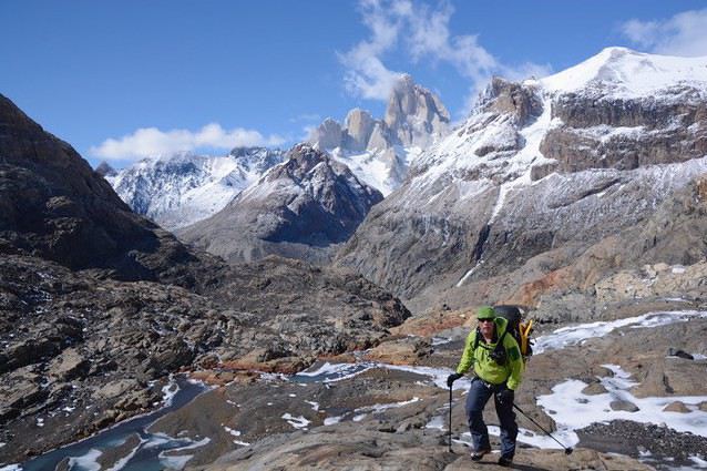
Nous partons à deux du 10 au 28 Janvier prochain à destination de l'Argentine, et plus précisément du massif du Fitz Roy puis de Torres del Paine ! =)
Nous avons prévu plusieurs itinérants (notament en fonction de la météo..! ^^) et nous adapterons sur place...
Un des tours que nous envisageons (si une fenetre météo s'ouvre) est le tour du Fitz Roy par le col Marconi et le col de viento. Pour cela nous serons équipés en terme de camping 4 saison et nous nous louerons sur place pour le matériel de progression sur glacier.
Néanmoins, nous ne savons pas si le passage sous le col Marconi sera en condition d'ici la (ou si les dalles seront seches, car on ne pense pas prendre trop de quincallerie.. =s). Je postais à la base ce message au cas ou il y ai du passage sur place d'ici la, savoir si un retour sur les conditions est possible !
De plus, nous ne seront que deux (avec un différentiel de poids conséquent, je suis bien plus lourd !), donc un mouflage pourrait être compliqué. Du coup, j'informais que si un groupe est présent à cette période et veut tenter le tour avec nous, vous serez les bienvenus =)
Attention toutefois, c'est très crevassé là derrière. J'avais croisé des gens qui en revenait quand je faisait la Vuelta de Huemul. 2 ponts de neiges avait cédés, mouflage impératif pour sortir la personne. Je comprend la problématique à 2, surtout avec un différentiel de poids, quelques entrainements de rappel du mouflage la semaine dernière m'ont rappelé à quel point c'était délicat à deux.
Pour l'état du glacier, je ne sais pas si cela avait été une année particulière, c'était en janvier 2017.
J'avais les infos datant de 2016 pour le Marconi, apparement, le passage devient de plus en plus délicat.
Tu peux aussi poster sur CamptoCamp, tu auras potentiellement plus d'infos qu'ici. ça sort d'un trek ordinaire quand même :)
Bon courage en tout cas et prudence,
Si vous avez plus d'infos après coup, je suis toujours preneur,
Julien
Pour des topos de treks et des informations précises sur les pays que j'ai visités, rendez-vous sur mon blog : https://treketvoyages.com/.
Il fonctionne comme un modeste guide de voyage et non comme un récit de voyage.
J'avais cru voir des retours similaires, ce qui m'inquiète un peu..!
Je vais tenter aussi sur C2C, et sur place à El Chalten ;)
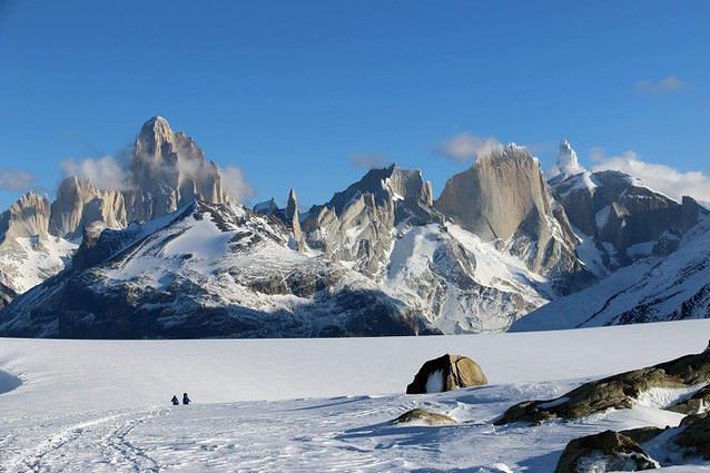
Vuelta de Huemul est un tour qui semble incroyable aussi (L'arrivée au dessus de l'embouchure du glacier dans le lac surtout o.0). C'est le second projet que nous avons envisagé si la fenêtre météo est de 3-4 jours ou si le pas de Marconi ne passe pas.
Je ferai forcément un retour en revenant de mon voyage, quelque soit les itinérant faits ! (A Tores del Paine aussi si j'ai le temps =).
Oui, le bureau des guides à El Chalten c'est une bonne idée. Il m'avait fourni beaucoup d'informations, et sans tenter de me faire la moral "vous savez c'est dangereux, faut un guide etc.". J'avais bien apprécié cette attitude. Peut-être que j'ai eu de la chance avec le ranger sur lequel je suis tombé.
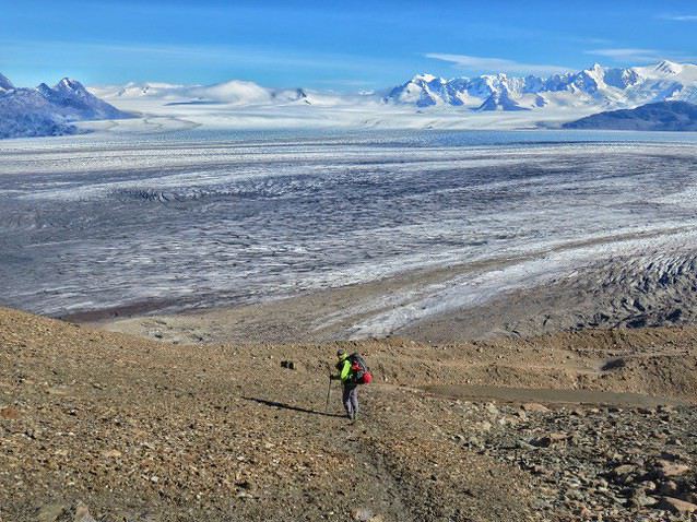
Je confirme, Vuelta de Humul c'est facile et magnifique ! On voit bien la Hielo Sur, c'est magique cette étendue de glace.
Pour les deux treks, il y a un permis (gratuit) à faire sur place avant de partir.
Bon voyage,
Julien
Pour des topos de treks et des informations précises sur les pays que j'ai visités, rendez-vous sur mon blog : https://treketvoyages.com/.
Il fonctionne comme un modeste guide de voyage et non comme un récit de voyage.
Bonsoir
Si ça peut vous aider, nous avons fait cet itinéraire en Novembre 2015.
A l'époque il était quasiment impossible de monter au Col Marconi par la voie classique, a droite les dalles était très sèche et comporter des pas d'escalade de 5 sup, a gauche ça pouvait passer mais terriblement dangereux en étant directement sous les séracs. Nous avons inauguré une nouvelle approche qui est entrain, je crois, de devenir l’access la plus simple meme s’il est pas mal plus longue. Apres « la playita » au bout du lac on prends la direction du nord et on traverse la rivière et on monte en direction de « Laguna de los 14 ». D’ici on peut monter directement pour rejoindre le glacier qui descends du Gorra Blanca. Avec un peu de recul je pense qu’on peut faire un camp le premiere nuit au Laguna, il y a des coins plat et la situation est sensationnel ! Ca permets également de raccourcir la deuxième journée jusqu’au Refuge Garcia Soto.
Si vous avez besoin d’autres infos n’hésitez pas de me contacter. En tout cas « La Vuelta » est une des plus belles treks sur terre, Je suis retourné en avril 2017 pour faire l’Huemul qui est pas mal non plus !
Merci pour vos deux retours !
Je vais garder ce parcours en tête au cas ou la voie "classique" est délicate... Si nous passons par la nous créerons l'itinéraire sur C2C pour les prochains =).
- En combien de jours avez vous fait le tour au final ?
- Etes vous partis et revenus de (à) El Chalten même à pied, ou avez vous pris un transport motorisé sur le début/la fin ? J'ai vu des gens faire cela, ce qui à froid ne me plait qu'à moitié mais permet (peu être ?) de raccourcir d'un jour la sortie si jamais la fenêtre météo est serrée.
Bonsoir
Nous sommes restés 15 jours bloqué a Chalten avec le mauvais temps et nous avons eu une courte fenetre a la fin de notre sejour qui nous a permis de faire "La Vuelta".
Donc, transfer par la route la premiere jour sous la neige jusqu'au pont sur le Rio Electrico, retour a Chalten a pied.
Au total, 6 jours ;
1) Electrico - La Playa
2) La Playa - Garcia Soto
3) Garcia Soto - Los Altares (dans le blizzard, GPS et Boussole indispensable)
4) Los Altares - Laguna Ferrari
5) Ferrari - Lago Toro
6) Toro - El Chalten
A priori l'ancien itineraire ne passe plus, si ca vous interesse j'ai un ami guide, Manuel Quiroga qui habite a Chalten qui pourrait peut etre vous informer
Sinon, nous avions un Inreach qui nous permettez d'avoir la meteo au moins deux fois par jour, sans ca nous aurions certainnement fait demi tour a Garcia Soto.
Bonjour
en février dernier, nous souhaitions faire à deux le tour du Fitz Roy. Le paso Marconi par le passage "classique" ne passait plus. Nous sommes montés juste "voir" (sachant qu'une tempête était annoncée), par la laguna 14. Devant l'approche du mauvais temps, nous nous sommes arrêtés au glacier dont l'accès ne semblait pas aisé en fin de saison (zone raide de glace noire après un mauvais pont de neige au-dessus du torrent glaciaire). Peut-être un accès plus haut (beaucoup plus haut sur la gauche) est-il plus aisé ?? Nous avons bien fait de redescendre à la playita. Un couple (dont un guide local) qui descendait, s'est arrêté en bas du glacier Marconi (pas loin de la tyrolienne) : leur tente a été arrachée et ils ont greloté dehors.
Ce trek fera partie des objectifs d'un nouveau séjour à El Chalten entre le 10 et le 25 février 2019.
Je suis preneur d'infos sur la meilleure manière d'accéder au Marconi (y compris depuis el paso del viento : malgré la remontée de la pente et les vents, ce sens ne donnerait-il pas plus de chances d'atteindre le champ de glace et el circo de los altares ??).
Du monde en même temps que nous ?
Evidemment, nous publierons nos propres informations, à notre retour.
Pierre et Marie-Jo
Bonjour Pierre,
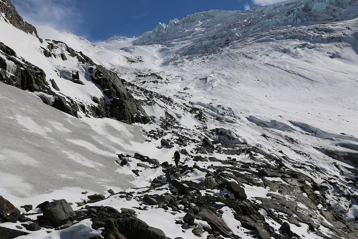
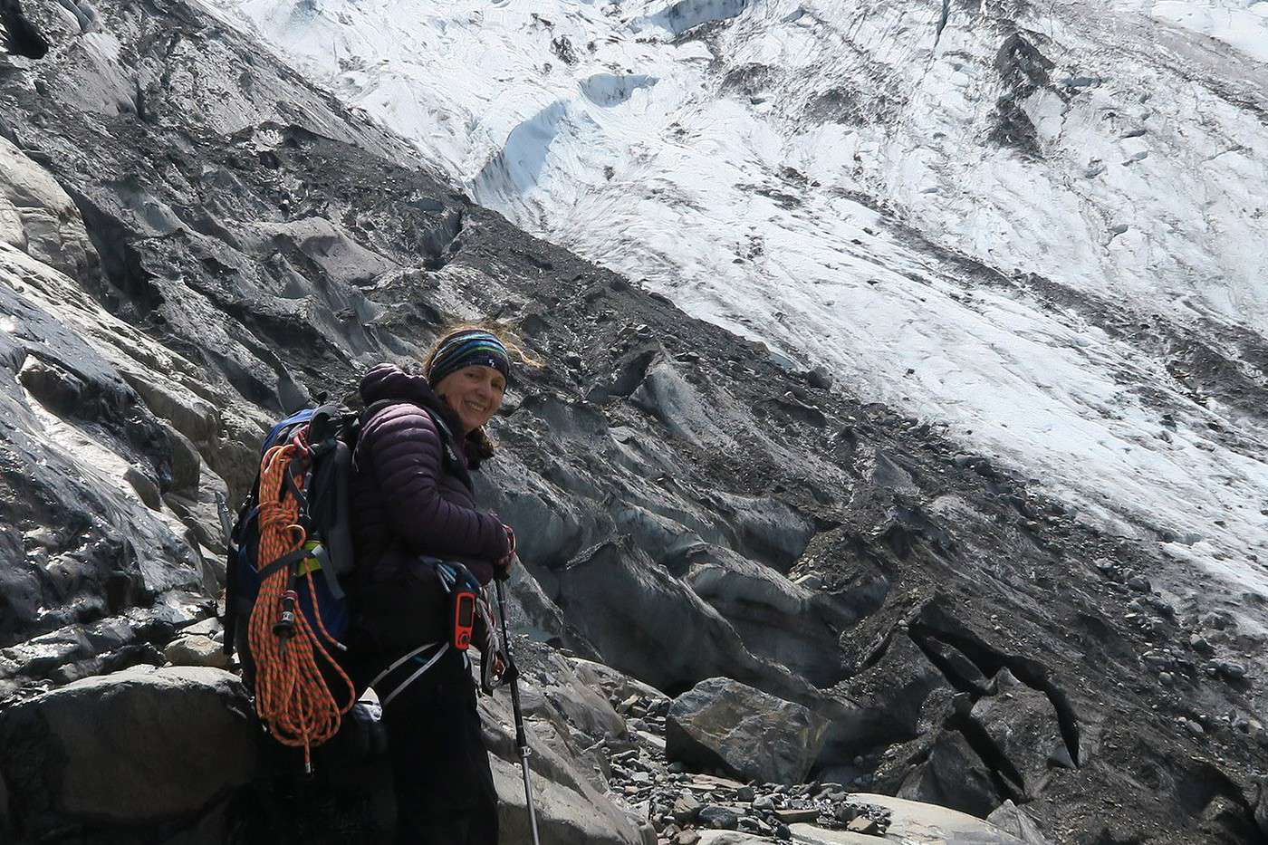
Nous avons pris une voie bien a gauche et a l'époque (mi novembre) ça passait tranquille pour prendre pied sur le glacier, peut être bien plus compliqué en février. J'ai mis une image pour que tu visualise un peu mieux. En tout cas l'accès par Laguna de los 14 me parait aujourd'hui plus simple et beaucoup plus sure que l'accès traditionnel par le glacier Marconi.
En ayant monté plusieurs fois à Paso del Viento, l’accès a l'icecap n'est pas très compliqué mais assez longue en passant par les moraines, par contre, s'il souffle un peu ( ! ) vous êtes continuellement face au vent, pénible, je pense.
En tout cas si vous avez besoin d'infos n'hésite pas a me contacter par message. Bonne journée
Jules
Bonsoir Jules
merci pour cette réponse !
Nous essaierons l'accès par la laguna 14 si le temps est stable. Si la fenêtre de beau temps est trop courte, on mettra le pied sur l'icecap par le paso del viento, pour au moins le voir !
Effectivement, les conditions sont très différentes entre novembre et février... La photo jointe est prise juste au bord du glacier, bien ouvert à cette saison. On ne voit pas le torrent glaciaire juste entre deux, qui n'était pas si simple à traverser.
Hâte d'être en Patagonie !
Pierre
Nous partons dans une semaine maintenant.
A moins de trouver un deuxième groupe pour faire le tour sur place, nous envisageons a posteriori de faire le Viento > Huemul (Ma compagne est beaucoup plus légère, et un mouflage à deux est compliqué...)
A moins d'avoir deux semaines de tempête, nous monterons quand même voir l'accès vers le passo Marconi (du coté du Lago 14 aussi). Nous ferons des retours des conditions tout début Février !
Je vais faire un trek de 16 jours dans le parc Nahuel Huapi. Mais voilà, le plus grand parcours ne fait pas plus de 10 à 13 jours à ce que j'ai trouvé sur le…
Mon amie et moi partons en Argentine en Janvier 2017 et nous voulons faire la Patagonie Argentine à pied car nous n'avons pas de moyens pour louer une voiture.…
Après le Torres del Paine, je voudrais poursuivre ma route vers El Chalten. Je voudrais m'arrêter au Perito Moreno pour le visiter. Combien de temps dois-je…
Lors de notre voyage en Patagonie prévu en novembre 2018, nous souhaiterions faire le big ice trekking sur le Perito Moreno. Toutefois il est indiqué que…
Je souhaiterais savoir si il y a des treks de 10 à 15 jours à faire en Argentine. Je suppose que oui, mais en surfant sur le net, je ne trouve pas grand chose.…
Hi,
We’re planning to do the 4-day trek from Mestia to Ushguli without an agency. The descriptions mention that there are accommodations at each stop, but we can’t find any details about them. Has anyone got info or feedback on this route?
We're planning to trek in Peru and Bolivia and would love to find some local agencies.
If you know any, could you share details on prices and, of course, the names of the agencies?
Which trek would you recommend?
Elocine
Je pars en autonomie totale sur un trek au Maroc (10jrs) Imilchil - Aghbalou.
Trouve t-on des cartouches gaz à vis (Coleman, Primus) à Marrakech (adresse) ou villages entre Imilchil - Aghbalou ?
Si non , trouve-t-on des cartouches Butagaz pour camping-gaz (petit volume 230 gr ...)
Merci d' avance pour vos réponses
Hello, I’d like to embark on a little trip in my home country, Switzerland. I’ll start walking from La Cure, heading toward Le Noirmont first, then I’ll improvise my route—but it’ll probably follow the French border... at least as far as Lac de Joux.
I’ll decide day by day how much farther to go after that. My goal is to stay in nature as much as possible, wander around for as long as I can, and restock food in villages or towns along the way.
I’m thinking of mostly camping, but we’ll see if I end up in a hotel or another campsite depending on my route.
I’d love to reach La Chaux-de-Fonds on foot... maybe even Delémont.
The whole thing should take about a week, give or take.
I’ll be bringing my dog, and I’m preparing for this as soon as I’m ready.
Any tips to make sure everything goes smoothly for us? Things I should know—or avoid? What about shepherds with their flocks of sheep? And isn’t hunting season open right now?
I’m not sure if what I’m planning is even doable, which is why I’m asking around.
This’ll be my first time doing something like this—wandering in nature *and* with a dog. I’m really excited for this adventure... and I need it. Thanks!
We’re really keen on ecosystems and want to hike in "natural" ancient forests—not planted woods or areas heavily degraded by human activity. Travel guides (like Lonely Planet) don’t provide much info on this. Could you point us to the most interesting spots?
Thanks in advance for your tips.
We wish you happy holidays and a fantastic 2026, full of discoveries!
Claire and Albert
Hi, this might not be the right section, but I’d like to know if it’s possible to start mountaineering with another person without necessarily hiring a guide. We’ve done quite a bit of hiking but not mountaineering—we’ll just do a half-day glacier course. After that, we were thinking of starting with La Grande Motte and the Pointe de la Traversière, which were recommended to us. Honestly, for things like roping up and knots, I’ll learn at home with lots of videos and a book.
Hi,
I don’t know Switzerland at all and was wondering if Vallée des Joux and especially Dent de Vaulion are packed early in the morning or late in the afternoon in July and September?
If so, do you have any quieter spots to recommend in the area, or in Luxembourg (yes, I know it’s not the same country 😉)?
Thanks a lot!
Jaimerais savoir si quelqu'un aurait fait des treks sur le Ruwenzori et combien ça coute en moyenne, les infrastructures, les paysages la sécurité sur les lieux, merci beaucoup. J'attends avec impatience vos réponses.
We’re leaving in 9 days for a two-week trip to Madeira, mainly to hike.
From my research, I’ve found that since last year, access to most trails—and systematically for the most popular ones—is now paid. You have to pay an access fee of 4.50 € per person per classified hike in 2026, and even 10.50 € for the most iconic hike: Pico Arieiro to Pico Ruivo. When paying, you also have to choose a day and a 30-minute time slot for your start time. Of course, this reservation is neither changeable nor refundable, even if the weather that day is terrible.
Personally, given the massive influx of tourists to the island in recent years, I don’t mind paying a fee to help maintain the trails. Similarly, setting a limit on the number of people who can hike them per day is certainly preferable to preserve this priceless heritage.
However, what’s much less fair is that in reality, most of the available spots are reserved: 1/ for Madeira residents (which is normal); 2/ for "economic operators" (meaning local tour operators). For example, if you’re a non-resident (independent tourist), no booking is possible for the Pico Arieiro hike for an early morning start before September! So, unfortunately, we’ll have to skip this hike.
It’s the same issue for Ponta de São Lourenço, the 25 Fontes, Pico Ruivo... in short, all the most popular hikes. Oh well, we’ll skip those too!
So my question is: which hikes do you recommend where we won’t face the huge crowds that the others get? And where we can book the day before for the next day, taking the weather into account?
Finally, a quick accommodation question: we’ve booked the first week in Funchal, but I haven’t decided yet for the second week. Do you have any advice on where to stay in the south or north, preferably avoiding overly concrete-heavy and touristy spots?
I’m reposting about the logistics for Samaria Gorge.
I’d love to get recent info, especially about whether it’s possible to park my car in Omalos, do the hike, and then catch a bus back to my vehicle.
In theory, it’s doable, but when you check the KTEL website, there aren’t any feasible schedules listed. If anyone has recently organized this with reliable, verified details, I’d really appreciate it. Thanks in advance!
Hi there,
We’re flying from Montreal to Lyon this August to go hiking in the French Alps. We’ve rented a car and will be staying at campgrounds. We’re planning to do day hikes and want to stay a few days in one spot, do a few hikes, then move on to our next camping spot. Could you share your favorite spots or any recommendations for places to spend a few days with great hikes?
A few details:
We arrive in early August and leave in early September.
We’re looking for day hikes (or shorter), moderate difficulty, with a cumulative elevation gain of no more than 1000m, and of course, beautiful scenery!
We’d prefer not to drive too much—maybe it’s best not to head too far south and deal with unnecessary heat?
Along the same lines, if you know of any great campgrounds where we can start our hike directly without needing the car, we’d love to hear your suggestions!
Bonjour
Souhaitant faire de la randonnée sur cette île, je voudrais d'abord savoir quelle serait la période la plus favorable sachant que j'avais passé quelques jours en novembre 2018 pas pour cette activité mais plus pour une simple découverte de l'île et le temps n'était pas top notamment en montagne. Donc peut on choisir une organisation en étoile sachant que je louerai un véhicule avec éventuellement 2 points d'hébergement.
Je n'envisage pas d'intégrer une structure mais de partir à 2 et de s'organiser sauf si vous me conseillez une agence locale ou un guide local. Enfin même si je compte me procurer les différents supports, carte et topo guide plus gps je vous remercie de bien vouloir me communiquer les randos à faire en priorité
Merci beaucoup pour vos informations
I’m planning to do the Mercantour crossing following the Randoxygène route in mid-July.
I’m used to hiking in the mountains, but I sometimes get vertigo, for example on ridges with drops on both sides. I wanted to check if there are any T4 or T3-T4 sections and find out if there are any very exposed passages—and if so, where—so I can plan an alternative route.
Can anyone give me some info on this?
Thanks!
I’m planning a trip around Cap Corse and the AGRIATES in 2026, from May 8th to 15th (there are still 2 spots left, by the way! Just DM me if you're interested).
I’d love to know which hikes are worth prioritizing in the AGRIATES. We’ll be staying in SALECCIA for two days as our base—what should we focus on from there?
A round trip to IGNHU beach? Any other suggestions?
For Ostricano, I think it’s too far for a round trip...
Thanks for your tips!
Have a great day,
Anie, Toulouse
I’d like to get some info about the GR10 Pyrenees traverse. I need help planning the daily stages and accommodations—my wife isn’t an experienced hiker but walks a lot, so I’d like to schedule shorter walking days and thus a longer overall trip in terms of number of days.
Could anyone give me some help and advice?
Best regards,
New to this forum, I’m planning a pretty big project for 2028.
I’m heading to Nepal to do a trek from Kathmandu all the way to Everest Base Camp (a cool 5,300 m 😄).
This trek is a bit special because even though I’ll be part of a group, I’m going solo (so far, no problem—I’m used to it). But it’s my first real trek, and it’s also a humanitarian one: once I reach base camp, I’ll stay an extra week to help clean up the waste left by tens of thousands of climbers! Since I’m originally from South America, from two countries that share the Andes, I have a deep respect for mountains—they fascinate me. So Everest… it’s kind of the trip of a lifetime!
So, a little question for those who’ve done treks to Everest before… any tips for good mental preparation (I’m already working on the physical side)?
Hi there, I’m planning the Annapurna Circuit for March 2027 and I’m looking for a local agency with a local guide—preferably French-speaking—to arrange this trek for us. Any suggestions? Thanks
Hello!
We’re spending a few days in Toraja country at the end of May. We’d love to do a day trek—taking our time—on a route that’s stunning in terms of scenery, but not a level 5 in difficulty!
Any suggestions you can share, please?
Thanks in advance
I’d like to do the Mare a Mare Sud in May over 4 days. I’ve found quite a few places to stay along the route, but I’m stuck on the start and finish.
I’ll be arriving by plane on Sunday evening and would like to start pretty early on Monday morning. Ideally, accommodation right at the trailhead (Alzu di Gallina) would be amazing, but I can’t find anything. Any tips?
Also, for the transfer from Figari Airport to Porto Vecchio or Alzu di Gallina?
At the end, I’d like to pick up a rental car—any advice on that too?
I’m traveling solo by plane to Catania in May and plan to hike the northern side of Etna, starting from Linguaglossa where I’ll arrive by bus. After that, I’d love some info on how to get up to Piano Provenzana (shuttles or hitchhiking), since it seems there’s no public transport except in the summer. Can you sleep there in a free or cheap refuge, or camp? And how far up can you go without having to hire a guide? Thanks in advance. Bernard.
Bonjour a tous,
je pars en voyage au Maroc en aout et nous allons commencer par nous arrêter a Chefchaouen(nous sommes en voiture).
Ma question: quelqu'un peut il m'indiquer un itinéraire de rando en boucle d'entre 5 et 7 jours aux départ de Chefchaouen dans le parc de Talassemtane passant si possible par le pont de dieux?Ou un guide papier qui en reunis quelques uns?
Nous privilégions le camping sauvage et les gites.
Merci d'avance
Hi there, for those who’ve been recently—is it possible to find other solo travelers in March on the island to share transport or room costs? It doesn’t seem easy to travel on a budget.
If you have any recommendations for simple lodgings or places with dorms, I’d love to hear them.
For those who’ve done multi-day treks while moving around: do you need to bring your own sleeping bag? I’d love to hear about itineraries you’ve done without a guide, just with a map and GPS.
Thanks, and have a great day!
Hi everyone!
We’re planning a 15-day road trip to Scotland this summer, specifically to explore and hike on Lewis and Harris—places we’ve never been before. We’ve visited other islands on previous road trips in Scotland (we usually go in April for a week). This would be our first time in Scotland in the summer and for 15 days. We’re looking at late August to early September.
I’m currently drafting the itinerary. We’d be crossing from Ullapool and were thinking of spending 3 nights on Harris and 4 nights on Lewis.
Does that sound balanced to you? Is it better to keep the same accommodation on Harris and the same on Lewis to explore the area? I’d love to hear about any past experiences you’ve had on these islands.
Thanks!
Hi there, I’m trying to leave for 15 days very soon to São Vicente. I’m either looking to join an agency or figure things out on my own to go hiking on one of these islands or both. From what I’ve seen, it’s not easy to organize with local transport, so it gets expensive. Can I use the services of a small local agency? I’m looking for the simplest way to hike for several days. Also, how do you get from São Vicente to São Nicolau? Thanks in advance and have a great day!
Aichatou
I’ve been wanting to do this for several years, and this year’s the one. Next September, I’ll be trekking in Tusheti (Georgia), from Omalo to Shatili.
Of course, I won’t be renting a vehicle that’d just sit unused. No problem getting to Pshaveli, but from there to Omalo, it’s a dirt road (still the case?)
There must be some form of public transport since there are so many guesthouses, and not all travelers come in a 4x4.
If any of you have been to Omalo, could you confirm that these shared transports exist and how often they run?
we’re planning a trip to Yellowstone and hoping to do a three-day backcountry hike if we get a permit.
if any of you have done this before, could you let me know if it’s possible to find water along the way? And if we can transport it, are we allowed to use a stove?
Hello,
I’ll be in Nepal from March 6th to 29th (we’re flying into Kathmandu via Varanasi and leaving via Delhi).
I’m a bit confused about the regulations requiring a guide.
My wife and I (we’re 63 and 64) aren’t experienced trekkers—we’re more used to walking on terrain with very moderate elevation changes. I’m looking for fairly easy hikes, possibly day trips.
Here are my questions:
- Does the Poon Hill trek from Pokhara require a guide, or is it better to go through a local agency? (I’ve seen a lot of them offering 4-day packages)
- I’d like to do a few multi-day hikes around Jomsom (Kagbeni, Mukitinath, Lupra, Marpha)... Do you need a guide for those, and can you find accommodations easily without booking in advance?
Last question—I’m really hesitant to lug around a sleeping bag or down jacket during our 6 weeks in India. Can you easily find these kinds of items at reasonable prices in Pokhara?
Thanks in advance for any tips you can share!
Yann