Skip to content
What to See in Uruguay

Travel guide · Uruguay

What to See in Uruguay

last edited Dec 11, 2019

UNESCO World Heritage Sites

Uruguay is home to two sites inscribed on the UNESCO World Heritage list:
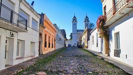
Centre historique de Colonia, Colonia, Uruguay
Historic Centre of Colonia (1995)
It’s a remarkable architectural blend of Portuguese and Spanish colonial styles. This is what earned it UNESCO World Heritage status.
Fray Bentos (2015)
This riverside port facing Argentina, along the Uruguay River, is nationally recognized for its industrial heritage. Its industrial legacy is UNESCO-listed.

Cities and Cultural Heritage

Cabo Polonio, Uruguay
Cabo Polonio
A charming small seaside resort in northern Uruguay, known for its large dunes and seal colonies.
Carmelo
This is the departure point for boats to the Paraná Delta or crossing to Buenos Aires/Tigre.
Chamanga
In the heart of the country, near the city of Durazno, Guarani rock art sites dating from the pre-Columbian era.
Colonia, Uruguay
Colonia
Officially called Colonia del Sacramento. Located on the banks of the Rio de la Plata, it is one of the most beautiful colonial cities in South America.
Fray Bentos
This riverside port facing Argentina, along the Uruguay River, is nationally recognized for its industrial heritage. Its industrial legacy is UNESCO-listed.
La Paloma
A renowned seaside resort on the Atlantic coast, La Paloma is a popular spot for surfing.
Mercedes
It's a port city on the Rio Negro, not far from the mouth of the Rio de la Plata. It's not very touristy, even though its riverside ramblas are well-known.
Montevideo, Uruguay
Montevideo
A pleasant capital city with historic neighbourhoods, Art Deco buildings, museums, and beaches.
Nueva Helvecia
This small town was founded by Swiss emigrants in the late 19th century. A modest tourism industry has developed locally around this theme.
Paysandú
It is the third-largest city in Uruguay. Located in the west of the country on the border with Argentina, it is separated from its neighbor by the Uruguay River.
Piriapolis, Uruguay
Piriápolis
A seaside resort between Montevideo and Punta del Este with some beautiful mansions, a pleasant waterfront, and a lively atmosphere.
Punta del Diablo
A small resort near Brazil, especially popular for surfing.
Punta del Este, Uruguay
Punta del Este
It’s "the" upscale and well-known seaside resort in Uruguay on the Atlantic coast.
Salto
Uruguay’s second-largest city is located in the west of the country. There are plenty of hot springs and thermal baths around Salto.
Tacuarembó
In the north of the country, it's the city of gauchos and (perhaps) of Carlos Gardel.

Natural Heritage

Esteros de Farrapos
National park encompassing several islands on the Rio Uruguay in the west of the country. It is home to a few pumas and wolves, as well as numerous bird species.
Laguna de Rocha
This body of water flowing into the Atlantic is a birdwatching spot. You can explore it by boat.
Rio de la Plata
This is the estuary separating Uruguay and Argentina. Crossing between Carmelo (Uruguay) and Tigre (Argentina) offers a pleasant trip through the many small islands on the Argentine side.
Quebrada de los Cuervos
A rather pretty canyon in the forest in the central-eastern part of the country.

Must-see & highly recommended

★★★★

Historic Centre of Colonia

It’s a remarkable architectural blend of Portuguese and Spanish colonial styles. This is what earned it UNESCO World Heritage status.
★★★★

Colonia

Officially called Colonia del Sacramento. Located on the banks of the Rio de la Plata, it is one of the most beautiful colonial cities in…

Worth a look / Other

★★

Cabo Polonio

A charming small seaside resort in northern Uruguay, known for its large dunes and seal colonies.
★★

Laguna de Rocha

This body of water flowing into the Atlantic is a birdwatching spot. You can explore it by boat.
★★

Montevideo

A pleasant capital city with historic neighbourhoods, Art Deco buildings, museums, and beaches.
★★

Piriápolis

A seaside resort between Montevideo and Punta del Este with some beautiful mansions, a pleasant waterfront, and a lively atmosphere.
★★

Punta del Este

It’s "the" upscale and well-known seaside resort in Uruguay on the Atlantic coast.
★★

Quebrada de los Cuervos

A rather pretty canyon in the forest in the central-eastern part of the country.
★★

Rio de la Plata

This is the estuary separating Uruguay and Argentina. Crossing between Carmelo (Uruguay) and Tigre (Argentina) offers a pleasant trip…
★

Carmelo

This is the departure point for boats to the Paraná Delta or crossing to Buenos Aires/Tigre.
★

Chamanga

In the heart of the country, near the city of Durazno, Guarani rock art sites dating from the pre-Columbian era.
★

Esteros de Farrapos

National park encompassing several islands on the Rio Uruguay in the west of the country. It is home to a few pumas and wolves, as well as…
★

Fray Bentos

This riverside port facing Argentina, along the Uruguay River, is nationally recognized for its industrial heritage. Its industrial legacy…
★

La Paloma

A renowned seaside resort on the Atlantic coast, La Paloma is a popular spot for surfing.
★

Mercedes

It's a port city on the Rio Negro, not far from the mouth of the Rio de la Plata. It's not very touristy, even though its riverside ramblas…
★

Nueva Helvecia

This small town was founded by Swiss emigrants in the late 19th century. A modest tourism industry has developed locally around this theme.
★

Paysandú

It is the third-largest city in Uruguay. Located in the west of the country on the border with Argentina, it is separated from its neighbor…
★

Punta del Diablo

A small resort near Brazil, especially popular for surfing.
★

Salto

Uruguay’s second-largest city is located in the west of the country. There are plenty of hot springs and thermal baths around Salto.
★

Tacuarembó

In the north of the country, it's the city of gauchos and (perhaps) of Carlos Gardel.

Cabo Polonio

A charming small seaside resort in northern Uruguay, known for its large dunes and seal colonies.

Overview of Cabo Polonio

A charming small seaside resort in northern Uruguay, known for its large dunes and seal colonies.

Key Details

  • Type of place: village.
  • Tourist interest: (worth seeing).
  • Location:
  • Distances:
  • Local time: Heure : 10054.
  • Population: 95 inhabitants (2011).
  • Area:
  • Altitude: sea level.

History of Cabo Polonio

What to See and Do in Cabo Polonio

Nearby

Climate and Weather in Cabo Polonio

Transportation

Getting There

Getting Around

Accommodation

Dining

Useful Addresses

  1. == Additional Information
View guide page: Cabo Polonio

Carmelo

This is the departure point for boats to the Paraná Delta or crossing to Buenos Aires/Tigre.

Overview of Carmelo

This is the departure point for boats to the Paraná Delta or crossing to Buenos Aires/Tigre.

Key Facts

  • Type of place: small town.
  • Tourist interest: (worth a stop if you are in the area).
  • Location:
  • Distances:
  • Local time: Heure : 10055.
  • Population: 18,041 inhabitants (2011).
  • Area:
  • Altitude: 23 m.

History of Carmelo

What to See and Do in Carmelo

In the Surrounding Area

Climate and Weather in Carmelo

Transportation

Getting There

Getting Around

Accommodation

Dining

Useful Addresses

  1. == Additional Information
View guide page: Carmelo

Chamanga

In the heart of the country, near the city of Durazno, Guarani rock art sites dating from the pre-Columbian era.

Overview of Chamanga

In the heart of the country, near the city of Durazno, these are Guarani rock art sites dating from the pre-Columbian era.

  • Type of site: petroglyphs.
  • Tourist interest: (worth a stop if you are in the area).
  • Features:
  • Area: over 120 km².
  • Altitude:

History of Chamanga

What to see and do

Practical information

  • Location:
  • Address: Rock art site "Chamangá", Uruguay.
  • Opening hours:
  • Fee:
  • How to get there:

Nearby attractions

  1. == In addition
View guide page: Chamanga

Colonia

Officially called Colonia del Sacramento. Located on the banks of the Rio de la Plata, it is one of the most beautiful colonial cities in South America.

Overview of Colonia

Officially called Colonia del Sacramento, the city is located on the banks of the Rio de la Plata. It is one of the most beautiful colonial cities in South America.

Key Facts

  • Type of place: small town.
  • Tourist interest: (must-see or highly recommended).
  • Location:
  • Distances:
  • Local time: Heure : 10057.
  • Population: 26,231 inhabitants (2011).
  • Area:
  • Altitude: 27 m.

History of Colonia

What to see and do in Colonia

Centre historique de Colonia, Colonia, Uruguay
Historic Centre of Colonia
It’s a remarkable architectural blend of Portuguese and Spanish colonial styles. This is what earned it UNESCO World Heritage status.

In the surrounding area

Climate and weather in Colonia

Transport

Getting there

Getting around

Where to stay

Where to eat

Useful addresses

Further information

View guide page: Colonia

Historic Centre of Colonia

It’s a remarkable architectural blend of Portuguese and Spanish colonial styles. This is what earned it UNESCO World Heritage status.

Overview of the Historic Centre of Colonia

It’s a remarkable architectural blend of Portuguese and Spanish colonial styles. This is what earned it UNESCO World Heritage status.

  • Tourist interest: (must-see or highly recommended).

History of the Historic Centre of Colonia

What to see

What to do

Events and entertainment

Practical information

  • Location:
  • How to get there:
  • How to get around:

Eating

Sleeping

What to see nearby

  1. == For further information
View guide page: Historic Centre of Colonia

La Paloma

A renowned seaside resort on the Atlantic coast, La Paloma is a popular spot for surfing.

Overview of La Paloma

A renowned seaside resort on the Atlantic coast, La Paloma is a popular spot for surfing.

Key Details

  • Type of place: small town.
  • Tourist interest: (worth a stop if you are in the area).
  • Location:
  • Distances:
  • Local time: Heure : 10058.
  • Population: 3,495 inhabitants (2011).
  • Area:
  • Altitude: sea level.

History of La Paloma

What to See and Do in La Paloma

Nearby

Climate and Weather in La Paloma

Transportation

Getting There

Getting Around

Accommodation

Dining

Useful Addresses

Additional Information

View guide page: La Paloma

Mercedes

It's a port city on the Rio Negro, not far from the mouth of the Rio de la Plata. It's not very touristy, even though its riverside ramblas are well-known.

Overview of Mercedes

It's a port city on the Rio Negro, not far from the mouth of the Rio de la Plata. It's not very touristy, even though its riverside ramblas are well-known.

Key Facts

  • Type of place: small town.
  • Tourist interest: (worth a stop if you are in the area).
  • Location:
  • Distances:
  • Local time: Heure : 10059.
  • Population: 41,974 inhabitants (2011).
  • Area:
  • Altitude: 28 m.

History of Mercedes

What to See and Do in Mercedes

In the Surrounding Area

Climate and Weather in Mercedes

Transportation

Getting There

Getting Around

Accommodation

Dining

Useful Addresses

  1. == Additional Information
View guide page: Mercedes

Montevideo

A pleasant capital city with historic neighbourhoods, Art Deco buildings, museums, and beaches. Overview of Montevideo Climate and Weather in Montevideo What to See in Montevideo Things to Do in Montevideo Flying to Montevideo Getting to Montevideo by Land or Sea Getting Around Montevideo Sleeping and Eating in Montevideo Living in Montevideo

Further Information

View guide page: Montevideo

Overview of Montevideo

Overview of Montevideo

It's a pleasant large capital with old neighbourhoods, Art Deco buildings, museums, and beaches.

Landmarks

  • Type of place: large city.
  • Tourist interest: (worth seeing).
  • Location:
  • Distances:
  • Local time: Heure : 10060.
  • Population: 1,305,082 inhabitants (2011).
  • Area: 201 km².
  • Altitude: sea level.

History of Montevideo

Precautions

Useful Addresses

  • Tourist Office:

Services

  • Local agencies:
  • Banks:
  • Hospital:
  • Internet:
  • Laundries:
  • Vehicle rental:
  • Post office:
View guide page: Overview of Montevideo

Climate and Weather in Montevideo

Climate Overview

Best Time to Visit Montevideo

Jan.Feb.Mar.Apr.MayJun.Jul.Aug.Sep.Oct.Nov.Dec.
Climate

Climate and Forecast

Further Information

View guide page: Climate and Weather in Montevideo

Flying to Montevideo

Montevideo Airport

Airport details

  • Name: Aeropuerto Internacional de Carrasco.
  • IATA code: MVD
  • Hub: Amaszonas.
  • Number of terminals: 1.
  • Passenger capacity/year:
  • Passenger traffic: 1,870,853 (2016).
  • Distance from city centre: 20 km northeast of the city.

Services

Sleeping at the airport

Transport to the city centre

Other nearby airports

From the rest of the continent

From Europe

Additional information

View guide page: Flying to Montevideo

Nueva Helvecia

This small town was founded by Swiss emigrants in the late 19th century. A modest tourism industry has developed locally around this theme.

Overview of Nueva Helvecia

This is a small town founded by Swiss emigrants in the late 19th century. A modest tourism industry has developed locally around this theme.

Key Facts

  • Type of place: small town.
  • Tourist interest: (worth a stop if you are in the area).
  • Location:
  • Distances:
  • Local time: Heure : 10061.
  • Population: 10,630 inhabitants (2011).
  • Area:
  • Altitude: 27 m.

History of Nueva Helvecia

What to see and do in Nueva Helvecia

In the surrounding area

Climate and weather in Nueva Helvecia

Transport

Getting there

Getting around

Accommodation

Eating

Useful addresses

  1. == Further information
View guide page: Nueva Helvecia

Paysandú

It is the third-largest city in Uruguay. Located in the west of the country on the border with Argentina, it is separated from its neighbor by the Uruguay River.

Overview of Paysandú

It is the third-largest city in Uruguay. Located in the west of the country on the border with Argentina, it is separated from its neighbor by the Uruguay River.

Key facts

  • Type of place: city.
  • Tourist interest: (worth a stop if you are in the area).
  • Location:
  • Distances:
  • Local time: Heure : 10062.
  • Population: 76,412 inhabitants (2011).
  • Area:
  • Altitude: 34 m.

History of Paysandú

What to see and do in Paysandú

In the surrounding area

Climate and weather in Paysandú

Transport

Getting there

Getting around

Accommodation

Food

Useful addresses

Further information

View guide page: Paysandú

Piriápolis

A seaside resort between Montevideo and Punta del Este with some beautiful mansions, a pleasant waterfront, and a lively atmosphere.

Overview of Piriápolis

It’s a seaside resort between Montevideo and Punta del Este with some beautiful mansions, a pleasant waterfront, and a lively atmosphere.

Key Facts

  • Type of place: small town.
  • Tourist interest: (worth seeing).
  • Location:
  • Distances:
  • Local time: Heure : 10063.
  • Population: 8,830 inhabitants (2011).
  • Area: 25 km².
  • Altitude: sea level.

History of Piriápolis

What to See and Do in Piriápolis

In the Surrounding Area

Climate and Weather in Piriápolis

Transportation

Getting There

Getting Around

Accommodation

Dining

Useful Addresses

  1. == Additional Information
View guide page: Piriápolis

Punta del Diablo

A small resort near Brazil, especially popular for surfing.

Overview of Punta del Diablo

A small beach resort near Brazil, especially popular for surfing.

Key Details

  • Type of place: village.
  • Tourist interest: (worth a stop if you are in the area).
  • Location:
  • Distances:
  • Local time: Heure : 10064.
  • Population: 823 inhabitants (2011).
  • Area:
  • Altitude: sea level.

History of Punta del Diablo

What to See and Do in Punta del Diablo

In the Surrounding Area

Climate and Weather in Punta del Diablo

Transportation

Getting There

Getting Around

Accommodation

Dining

Useful Addresses

Further Information

View guide page: Punta del Diablo

Punta del Este

It’s "the" upscale and well-known seaside resort in Uruguay on the Atlantic coast.

Overview of Punta del Este

It’s "the" seaside resort, rather upscale and well-known, in Uruguay on the Atlantic coast.

Key Facts

  • Type of place: small town.
  • Tourist interest: (worth seeing).
  • Location:
  • Distances:
  • Local time: Heure : 10065.
  • Population: 9,277 inhabitants (2011).
  • Area: 20.35 km².
  • Altitude: sea level.

History of Punta del Este

What to See and Do in Punta del Este

In the Surrounding Area

Climate and Weather in Punta del Este

Transportation

Getting There

Getting Around

Accommodation

Dining

Useful Addresses

Additional Information

View guide page: Punta del Este

Salto

Uruguay’s second-largest city is located in the west of the country. There are plenty of hot springs and thermal baths around Salto.

Overview of Salto

The second-largest city in Uruguay is located in the west of the country. There are plenty of hot springs and thermal baths around Salto.

Key facts

  • Type of place: city.
  • Tourist interest: (worth a stop if you are in the area).
  • Location:
  • Distances:
  • Local time: Heure : 10066.
  • Population: 104,028 inhabitants (2011).
  • Area:
  • Altitude: 51 m.

History of Salto

What to see and do in Salto

In the surrounding area

Climate and weather in Salto

Transport

Getting there

Getting around

Accommodation

Food

Useful addresses

Further information

View guide page: Salto

Tacuarembó

In the north of the country, it's the city of gauchos and (perhaps) of Carlos Gardel.

Overview of Tacuarembó

In the north of Uruguay, it's the city of gauchos and (perhaps) of Carlos Gardel.

Key facts

  • Type of place: city.
  • Tourist interest: (worth a stop if you are in the area).
  • Location:
  • Distances:
  • Local time: Heure : 10067.
  • Population: 54,755 inhabitants (2011).
  • Area:
  • Altitude: 140 m.

History of Tacuarembó

What to see and do in Tacuarembó

In the surrounding area

Climate and weather in Tacuarembó

Transportation

Getting there

Getting around

Accommodation

Eating

Useful addresses

  1. == Additional information
View guide page: Tacuarembó

Esteros de Farrapos

National park encompassing several islands on the Rio Uruguay in the west of the country. It is home to a few pumas and wolves, as well as numerous bird species.

Overview of Esteros de Farrapos

This is a national park encompassing several islands on the Rio Uruguay in the west of the country. It is home to a few pumas and wolves, as well as numerous bird species.

Key Details

  • Type de lieu: national park.
  • Intérêt touristique: (worth a stop if you are in the area).
  • Caractéristiques:
  • Heure locale: Heure : 10068
  • Fréquentation annuelle:
  • Superficie: 202 km².
  • Altitude:

Environment

Landscape of the Park

Wildlife and Flora

Climate

Precautions

What to See

What to Do

Practical Information

  • Localisation:
  • Distances:
  • Période d'ouverture:
  • Tarifs:

Getting There

Getting Around

Accommodation and Dining

Nearby Attractions

  1. == En complément
View guide page: Esteros de Farrapos

Laguna de Rocha

This body of water flowing into the Atlantic is a birdwatching spot. You can explore it by boat.

Overview of Laguna de Rocha

This body of water flowing into the Atlantic is a birdwatching spot. You can explore it by boat.

Key Facts

  • Type of place: birdwatching site.
  • Tourist interest: (worth seeing).
  • Features:
  • Area: 72 km².
  • Altitude: sea level.

Site Environment

Wildlife and Flora

Climate and Weather

Precautions

What to See and Do

Practical Information

  • Location:
  • Distances:

Getting There

Accommodation and Dining

Nearby Attractions

  1. == En complément
View guide page: Laguna de Rocha

Rio de la Plata

This is the estuary separating Uruguay and Argentina. Crossing between Carmelo (Uruguay) and Tigre (Argentina) offers a pleasant trip through the many small islands on the Argentine side.

Overview of the Rio de la Plata

This is the estuary separating Uruguay and Argentina. Crossing between Carmelo (Uruguay) and Tigre (Argentina) offers a pleasant trip through the many small islands on the Argentine side.

Key Details

  • Type of place: sea inlet.
  • Tourist interest: (worth seeing).
  • Features:
  • Length: 290 km.

Environment

What to See and Do

Practical Information

  • Location:
  • Website:

Getting There

Sleeping and Eating

Nearby Attractions

Additional Information

View guide page: Rio de la Plata

Quebrada de los Cuervos

A rather pretty canyon in the forest in the central-eastern part of the country.

Overview of Quebrada de los Cuervos

It’s a rather pretty canyon in the forest in the central-eastern part of Uruguay.

Key details

  • Type of place: canyon.
  • Tourist interest: (worth seeing).
  • Features:
  • Length:
  • Depth:
  • Altitude:

Canyon environment

Wildlife and flora

Climate

Precautions

What to see and do

Practical information

  • Location:
  • Distances:

Getting there

Getting around

Sleeping and eating

What to see nearby

  1. == En complément
View guide page: Quebrada de los Cuervos

Fray Bentos

This riverside port facing Argentina, along the Uruguay River, is nationally recognized for its industrial heritage. Its industrial legacy is UNESCO-listed.

Overview of Fray Bentos

This riverside port facing Argentina, along the Uruguay River, is nationally recognized for its industrial heritage. Its industrial legacy is UNESCO-listed.

Key facts

  • Type of place: small town.
  • Tourist interest: (worth a stop if you are in the area).
  • Location:
  • Distances:
  • Local time: Heure : 10075.
  • Population: 24,406 inhabitants (2011).
  • Area:
  • Altitude: 15 m.

History of Fray Bentos

What to see and do in Fray Bentos

In the surrounding area

Climate and weather in Fray Bentos

Transport

Getting there

Getting around

Accommodation

Eating

Useful addresses

Further reading

View guide page: Fray Bentos

Something wrong or out of date? Report this page