February 2025: The M'semrir-Tamtatoucht link via P7104 is fully paved, allowing you to complete the Dadès-Toghra loop via the pass.
Alas, alas, alas...
This "mythic" route, which offered the bold the crossing of Tizi n'Ouguerd Zegzaoun at 2,639 m in conditions that weren’t always easy—this track that connected not much (Msemrir) to nothing at all (Tamttoucht) while passing through a stunning high-altitude middle of nowhere—this track that served no villages and whose only purpose was to provide Msemrir with an alternative route in case of flooding on the Dadès—this track, I say, has just been completely ruined in its central section, the most beautiful part.
Instead of intelligently adapting the route to the terrain, they chose the opposite approach: the mountain in the way? Let’s "scrape" it. The debris? No problem. In the best case, it’s dumped into the ravine. Otherwise, it’s piled up by the roadside...
Reducing territorial and social disparities in rural areas...
And a budget of 42,290,000 MAD...
Sure, you can now cross the range in a Clio. No need for a 4x4 or a beldi pickup.
But the "rural world" still uses the old track, with donkeys and mules...
A few glimpses of the lovely embankments...
Off you go! It’s all straight now, and there’s nothing left to see...
In conclusion: If you want to "do the loop" Dadès-Todgha, avoid this shortcut.
Take the route via Agoudal instead. It’s paved too...
Boumalne-Msemrir-Tilmi-Agoudal-Aït Hani-Tamttoucht-Todgha Gorge-Tinerhir.
Totally agree. It’s fast, but the environment wasn’t respected at all.
What’s disheartening is seeing that an engineer (I assume there must be someone with that level of technical decision-making leading the project, and that they’ve been on-site...) doesn’t show the slightest concern for the environment.
Just a decade ago, that wasn’t the case—some stunning "impossible roads" (like the 307, the 317, and the Ahançal link to the Aït Abdi) were built.
Now, they’re making them straight, flat, and wildly oversized—roads that often serve no real purpose. But hey, "the standards" are met.
Another disaster is unfolding on the forest track section (gorgeous!) of the Zawiat Ahançal-Cathédrale route.
Endangered landscape...
They’re gonna give you some nice smooth tarmac!
View of the Cathédrale yesterday.
View of the embankment... today...
You can just make out the top of the Cathédrale.
P.S.: I was confronted by the site foreman for taking these photos...
😎
What a shame. I did it in 2015 with a Pajero and kept an unforgettable memory of it, planning to go back that way the next time I was in this magnificent region. So remote. Stunning in its preserved vastness. And nope 😢
I also remember a guy who ran a small café-restaurant in his sheepfold along the track, just before reaching Tamtatoucht. He kept tin cans to build miniature violins. "Barbarian Stradivarius," as he called them. I wonder if he was spared by the heartless bulldozers with no respect for anything 😢🏗️
What a shame. I did it in 2015 with a Pajero and kept an unforgettable memory of it. I was planning to go back that way the next time I was in this magnificent region. So remote. Stunning in its preserved vastness. And nope 😢
That’s exactly the right way to put it.
I also remember a guy who ran a small café-restaurant in his sheepfold along the track, just before arriving at Tamtatoucht. I wonder if he was spared by the heartless bulldozers with no respect for anything 😢... 🤬
Yes and no. He’s still in the same place, but "the road" doesn’t go past there anymore. It starts at the western exit of Tamtatoucht, whereas he’s on the old access to the track, east of Tamtatoucht.
I found a photo from my last trip in 2022.
At that time, the link was divided into 3 sections:
- Near Tamtatoucht: a prepared but unpaved track. Abandoned construction site.
- Near M’semrir: a superb highway and major collateral damage
- Between the two, on the east side of the pass: the old-school track in its original state.
Hence these few photos, In Memoriam...
(De profundis clamavi ad te, Domine, but it’s ruined now...)
The legendary, untouched Dadès-Todgha of yesteryear.
This winding route must be the nightmare of the public works engineer.
Why respect the curve of the oued when you can cut straight through the mountain and make a 6-meter-wide straight line?
A little humor...
Arrival at Tizi n'Ouguerd Zegzaoune, east side.
Here, it’s simple: cut everything to the left and go straight.
And the debris, to the right.
I see with horror that my phone’s autocorrect messed up my message 😨: Berber Stradivarius! We were all in awe of how pure the music sounded. Incredible
Hi, I m looking for recent info about the track between Nkoud and Boumaine du Dadès via Tizi N'Tazazerte. Is it still a dirt track or is it now a paved road?…
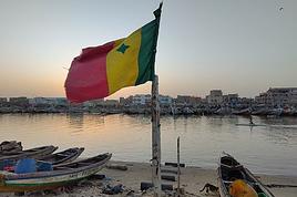
I haven’t been back to Senegal or Mauritania in a good fifteen years, so I imagine a lot has changed.
My trip starts in Dakar. I’ll head up to Saint-Louis, then cross into Mauritania. Drive to Nouakchott, take the track along the beach and Banc d'Arguin, then Nouadhibou and on to Morocco.
I’m looking for some info on administrative formalities, permits, visas, etc., regarding:
- Crossing the Senegal-Mauritania border at Diama (I’m in a car)
- Crossing Banc d'Arguin
- Exiting Mauritania at Guerguerat and entering Morocco
For my 60th birthday (yes, I’m jumping the gun a bit!), I’m starting to plan a self-drive trip to Tanzania (in June).
I also considered Zimbabwe but I’m worried it might be a bit chilly at night in June.
I’ve revisited an itinerary I’d thought about before, tweaking it since I’ll have more days to dedicate to this trip. Still no big northern classics for the same reasons as before (too expensive, too crowded, too many tour operators).
Here’s what I’ve got so far:
(Arrival/departure from Kilimanjaro Airport)
Night 1: Arusha
Night 2: Arusha
Night 3: Lake Manyara
Night 4: On the way to Iringa (any ideas???)
Night 5: Iringa
Nights 6–8: Ruaha NP
Nights 9–10: Mikumi NP
Night 11: Bagamoyo
Nights 12–15: Beach
Nights 16–17: Lushoto
Nights 18–19: Mkomazi NP
Night 20: Toward Marangu – eastern Kilimanjaro
Night 21: Western Kilimanjaro
End of trip
All your ideas, tweaks, info, and suggestions on this route are welcome!
I could move one beach night somewhere else if needed.
Also, if you have a car rental company to recommend or thoughts on the bandas rented in the parks, I’m all ears!
Finally, what are the roads like in Ruaha in June? The rental company I’m looking at seems to allow this park with a small 4x4. (Off-limits: Serengeti and Natron)
Hi,
We're heading to Chile in a month and have rented a 4x4 pickup with a camper cell to travel part of the Carretera.
The Ioverlanders site is really ideal for planning the route, with info on lots of things and especially on spots where you can park for the night.
I found a site about ongoing roadworks on the Carretera, Planifica tu viaje. When I look, it seems there are tons of roadworks, sometimes with roads closed for several hours or at least alternating traffic, which really extends travel times.
Has anyone recently traveled on Ruta 7 and can give us some "real" info?
Thanks in advance!
Céline
I’m in the middle of planning a round-the-world 4x4 trip spread over 2 years, covering around 70 countries. Unfortunately, using a vehicle poses some challenges when it comes to moving between continents (e.g., the Bering Strait). After lots of research, consulting books, maps, and making countless phone calls, I still can’t figure out how to get from Russia to Alaska via the Bering Strait (access via the Road of Bones to Magadan and then continuing above Anadyr).
So, I’m open to any recommendations, tips, or contacts to find out if it’s possible by boat or any other means.
After 40 years of traveling in Morocco, I want to explore a new area by 4x4—the Western Moroccan Sahara, which I don’t know very well.
I have plenty of tracks and itineraries, but I’d love some info to help me decide on the best route:
Part 1:
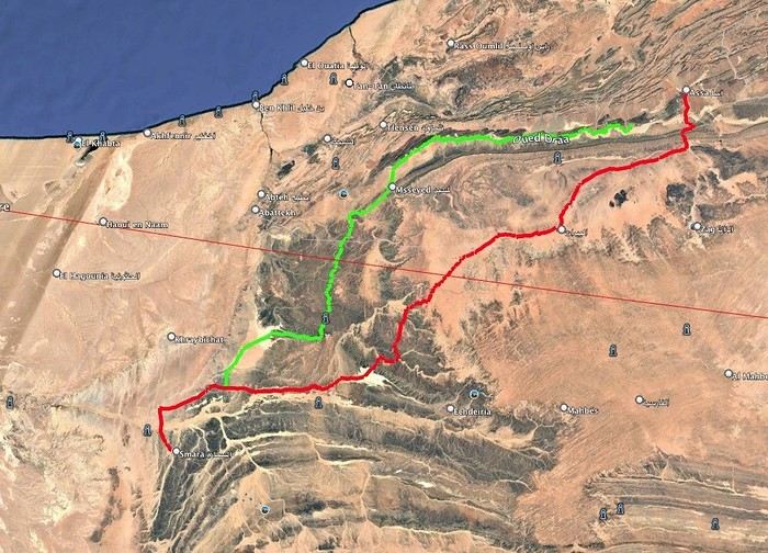
I want to do the ASSA - SMARA crossing. Basically, I have two options: the first follows the Draa River and goes through M’SIED, and the second is much further south, passing through LABOUIRAT and heading straight to SMARA.
If you have any details on road conditions, driving restrictions, etc., I’d really appreciate it.
Part 2:
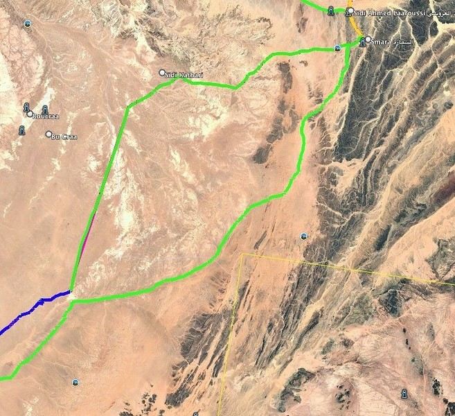
SMARA - BIR ANZERANE - DAKHLA – here, I also have two routes.
The first heads west from Smara toward Sidi Kathari.
The second goes east from SMARA and gets pretty close to the border at one point (about 10 km away).
Both routes meet up about 150 km later and are nearly identical from there to BIR ANZERANE and DAKHLA.
Hi,
For next summer’s vacation, I’m thinking of returning to the Sahara after visiting Tamanrasset and the Hoggar, which was stunning—not to mention the Tuareg hospitality.
I’d like to explore the sandy desert this time since the Hoggar was 80% rocky.
So, I’m wondering which city I should prioritize if I want to go there in late July–early August for the landscapes, extreme heat, and guides offering 4x4 and camel treks. Also, if there are any recommended guides for those in the know and a decent hotel.
I’m torn between Djanet, In Salah, Adrar, Ghardaïa, and Timimoun.
I’m of Algerian origin, so no visa or other formalities to worry about.
Thanks.
Hello, I’m preparing for a Tunisia-Algeria road trip.
I need to know if we can cross the Sahara to reach Djanet and Tamanrasset by road freely,
After that, obviously off-road in the desert with a guide.
What do the authorities say?
My trip: northern and southern Tunisia, a stroll in the desert.
Crossing the Tunisia-Algeria border via the Taleb Larbi customs.
I’ve already done this route through an agency, but this time we want to do it on our own.
Then heading down to Djanet for eight to fifteen days in the desert with Mouloud, a local guide.
Direction Tamanrasset: road and tracks, the mountains of the Assekrem, the Hermitage of Père de Foucauld.
Return via the Trans-Saharan Highway.
Visit to northern Algeria, then back by boat from Oran to Spain.
Dates: late December to mid-February.
We’ve got plenty of time.
If another crew is interested, we’re already two vehicles.
Looking forward to your replies.
Hi there,
I’m planning a trip to Russia and Mongolia, starting from France.
Crossing the border at Poland/Belarus or Georgia/Russia—other borders seem either closed or complicated.
Tourist visas for 3 months with multiple entries.
Do you have any info on Russian companies that cover a 4x4 vehicle for 3 months, and what prices in rubles or euros you’ve paid?
Which bank did you use for expenses? (EuroMastercard and Visa cards no longer work.)
Regarding Russian SIM cards, a new system called "Gosuslugi" has been introduced. How long did it take you to get one, and what steps did you follow?
Hi there,
We’ll be traveling in January 2027 in a 4x4 with a rooftop tent with our three kids, from Johannesburg to Cape Town. We’ve already booked several campsites in national parks (Golden Gate / Mountain Zebra / Addo Elephant / Garden Route).
We still need to reserve the stretch between De Hoop Nature Reserve and Cape Town. Any suggestions?
We’d love to stay around Cape Town for 5 days to explore the wine route, the peninsula, and do some hikes in Table Mountain.
Any camping recommendations? Or, on the contrary, places to avoid?
Also, we have 2 nights left near Wilderness National Park / Knysna. Any recommendations?
Thanks so much for your help!
We’re planning a long-term trip starting in April with our 4x4, beginning in the USA.
We’re still looking for car insurance that covers Canada and the USA.
We’ve read quite a few forums, but we’re hoping for some help (from fellow travelers).
Hi,
we’re planning to visit a park again.
Could you point us toward the camps in Gonarezhou Park?
>We’re traveling completely self-sufficiently.
We love wildlife.
Thanks for any tips you can share!
JP
Hi there, we’ll be in Mozambique in early December 2026 and we’d like to travel from Vilanculos to Beira by car or bus to reach Beira airport. After that, we’re planning to visit Gorongosa National Park before flying back to France from Beira. From what we’ve heard, the road to Beira is tricky, especially at this time of year (start of the rainy season). Could anyone share their thoughts or suggest a solution? Thanks so much for your help!
Anne
Hi there,
I’m heading to Lesotho in a few days and I’m struggling to find info on the best route between Katse Dam and Sehlathebe National Park. There’s a fairly "direct" route from Thaba Tseka, but the roads seem rough, and we’re not exactly 4x4 pros. Anyone have any tips to share? Thanks!
Hi everyone,
We’re heading to Mozambique in October and are looking for either a 4x4 or 4x2 rental in Maputo, or a driver transfer option to reach:
- Ponta Do Ouro
- Tofo
- Vilankulos
The idea is to be self-sufficient for sightseeing and stops while still being able to access certain lodges or beaches that require a 4x2.
Do you have any contacts, addresses, or ideas to share?
Thanks in advance,
Hello,
We're hitting the road again in 2027 to discover new countries and cultures.
Could anyone give me some tips on driving from Ulaanbaatar to Lake Baikal and the route to take?
Thanks, and safe travels to those who are setting off!
We’re planning a 4x4 trip from Belgium to Central Asia, passing through Georgia, Russia, Uzbekistan, Kazakhstan, and Kyrgyzstan.
For these countries, our national insurance obviously doesn’t cover the vehicle, so we’ll need to get local insurance.
Will it be a problem if the vehicle is registered under person A and the national insurance is under person B? Both A and B will be in the vehicle, and both will be listed as drivers on the insurance.
When we get the local insurance, if we again list A and B as drivers, does the order matter? Could we get stuck at the border for this reason?
Hi,
For those who’ve driven on Iceland’s gravel roads in their own or a rented Duster, could you tell me what tires were fitted on the vehicle?
Were they All Terrain tires or more "standard" ones like all-season tires, for example?
Follow-up question: if they were "standard" tires, did that cause any issues on the gravel roads and rough terrain?
Thanks so much for any info you can share.
Best,
Marc
Hi there,
I'm planning a 4x4 road trip from Darwin to Broome with a rooftop tent in July 2026.
I'd like to know if I need to book overnight stops in advance or if I can just wing it and stop wherever I feel like it?
Some evenings, we'd like to stop and make use of campsite facilities (restaurant, shop, showers, toilets).
What do you recommend?
Do I need a permit?
My rough itinerary looks like this:
Darwin - Kakadu
Kakadu - Nitmiluk
Nitmiluk - Kununurra
Kununurra - Purnululu
Purnululu - El Questro
El Questro - Mt Elizabeth - Bell Gorge - Broome
I’m planning a trip to Iceland for next July-August, with a car and tent, and I’m wondering about booking campsites.
From your experience, is it necessary or even essential to book campsites in advance, or do you always manage to find a spot to pitch your tent?
We’ll also have the option to sleep in the car without pitching the tent.
Does that give us the flexibility to stay outside a campsite for a night here and there?
Hi,
I’m planning a road trip in the Middle Atlas, starting and ending in Fez and heading down to the south of Midelt, the Assoul Massif.... We’ll be traveling with two small 4x4s.
I’m looking for detailed maps of this region that include small roads and tracks.
Last year, we had a fantastic road trip in the Anti-Atlas and High Atlas using Erfahren maps, but unfortunately, they don’t cover the area we’re interested in this year.
Thanks for your suggestions!
Dominique
We’re planning a 13-day family road trip in Morocco this July, with six people in a Toyota Prado 4x4 (renting in Marrakech).
We’ll alternate between bivouacking and small hotels/riads depending on the stops.
Here’s the planned route (in this order):
Marrakech
→ Ouarzazate
→ Draa Valley
→ Zagora
→ Erg Chegaga
→ Lake Iriki
→ Foum Zguid
→ Tata
→ Tafraoute
→ Aït Mansour
→ Tiznit
→ Mirleft
→ Taroudant
→ Back to Marrakech
Our goal:
Atlas Mountains + desert + dunes + plateaus + valleys + a bit of coastline.
We’ll cover about 1,700 km in total.
We’re planning:
Bivouacking in the Chegaga/Iriki area
Flexible for the rest (booking the day before or same day)
Sand gear: traction plates, compressor, tow strap, roof rack
Questions:
Is the Zagora → Chegaga → Iriki → Foum Zguid crossing in July doable on our own (single vehicle, no guide)?
Are there any truly technical or risky sections between Chegaga and Iriki?
Does the overall itinerary seem manageable in 13 days without rushing?
Any suggestions for great bivouac spots or particularly interesting stops along this route?
The points on the route are provisional overnight stops. Some spots will include two nights in the same area.
We’re used to off-road driving, but not yet in the Moroccan desert.
Thanks in advance for your feedback and tips! 😊
Good evening
I could use some advice 🙂
Our trip to Namibia is planned for June/July 2026.
We’re struggling a bit with timing and choosing activities for the part of the trip between Sesriem and Brandberg.
Day 1: Sesriem to Mirabib
Day 2: Mirabib to Swakopmund – visit Swakopmund, overnight in Swakopmund
Day 3: Sandwich Harbour – overnight in Swakopmund
Day 4: Kayaking with the seals + the living dunes – overnight in Swakopmund
Day 5: Moon Landscape, Henties Bay + Cape Cross – overnight at White Lady Lodge in Brandberg
Does this itinerary seem realistic to you? Is Cape Cross really worth the trip? If I had to choose between Cape Cross and kayaking with the seals, which would you recommend?
Thanks in advance for your help!
Hélix
My son and I are heading to Georgia this summer to explore the High Caucasus (Svaneti, Kazbek, and Tusheti regions). For this, we’re planning to rent a 4x4.
However, the rental agencies we’ve found prohibit driving on the tracks to Omalo (Tusheti) and/or Ushguli (Svaneti).
Do you know of any agencies in Tbilisi (local and reliable) that allow rented 4x4s to drive on these tracks? If so, which ones?
Hi everyone,
I’m starting to plan an itinerary for September 2027 focused on Zimbabwe and Zambia. I’d love to visit Gonarezhou National Park—I see there are two sectors: the Mwenezi Region in the south and the area around the Runde River in the north. Should I cover both sectors or just focus on the northern region?
For the parks along the Zambezi River, is it better to visit Mana Pools on the Zimbabwe side or Lower Zambezi on the Zambia side?
Thanks in advance for any tips on the parks in these two countries.
Have a great day, everyone.
We’re spending 18 days in New Zealand from 05/04 to 05/21, arriving in QUEENSTOWN and leaving from AUCKLAND.
Any ideas for a road trip that covers the highlights of both islands but only changes hotels every 3–4 nights?
Thanks.
For our trip to Georgia in July, I’d like to rent a 4x4 starting from Tbilisi.
Do you have any rental companies to recommend?
The traditional rentals like Hertz, Avis, etc. seem way overpriced compared to local companies—what do you think? Are they properly insured?
Has anyone here tried Geo Rent Car, Auto 4 Rental, or Sur Price?
Also, I’m looking for info on the condition of the Ushguli–Lentekhi track—is it passable?
Hi everyone,
A well-prepped 4x4, a travel plan across Africa in stages since I’ve got kids to see regularly and work to earn a living.
I’m leaving in November for about a month with the goal of reaching Senegal via Mauritania. I’d love to share this trip with someone who wants to discover Mauritania and a bit of Senegal... and also experience life on board a 4x4 in the desert or bush, sometimes sleeping in the vehicle or in hostels/small hotels for comfort. I want to share this rediscovery because two’s better than one!
Just traveling, exploring, and living! !
 Reducing territorial and social disparities in rural areas...
And a budget of 42,290,000 MAD...
 But the "rural world" still uses the old track, with donkeys and mules...


 Off you go! It’s all straight now, and there’s nothing left to see...


 P.S.: I was confronted by the site foreman for taking these photos...
😎
 At that time, the link was divided into 3 sections:
- Near Tamtatoucht: a prepared but unpaved track. Abandoned construction site.
- Near M’semrir: a superb highway and major collateral damage
- Between the two, on the east side of the pass: the old-school track in its original state.
Hence these few photos, In Memoriam...
(De profundis clamavi ad te, Domine, but it’s ruined now...)


 Here, it’s simple: cut everything to the left and go straight.
And the debris, to the right.

 Your photos of Morocco
 Northern Morocco, the kingdom of kif?
 Spring getaway in search of Moroccan sunshine
 Trip to Morocco in September-October 2025, in our camper van
 18 days of bliss in Morocco!
 Family trip from Marrakech to the desert
 Beautiful stops and sites discovered in Morocco in March
 From Avignon to Casamance Without Flying