Results for "Kirghizistan+hébergement"
About 2,701 results.
More options
Many results are in French, the community’s main language. English translations are added over time.
Search results
Practical aspects spring 2026: border to Murmansk, to Pskov, SIM cards, internet.
I took a few days to get some fresh air outside the Schengen-NATO prison. Between March 18, 2026, and March 25, 2026, as shown by the passport stamps:
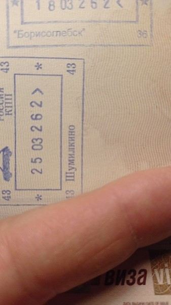
Borisoglebsk is the Russian border checkpoint after Kirkenes, on the road to Murmansk.
Kirkenes is a tiny town with a correspondingly small airport. Nothing has changed there: the minibuses to Murmansk wait on the right as you exit the airport. They’re synchronized with the two daily flights from Oslo—the SAS around 11:00 AM and Norwegian around 11:30 AM. They stop in Kirkenes at the corner of the Scandic for an hour, where other passengers can board, then head straight to the nearby border.
This is the least hassle Frontex/Schengen border. The Norwegian agent quickly scans your passport, and that’s it. No customs, since Norway is Schengen but not in the EU. On the Russian side, there’s a passport check and a quick customs inspection. All in all, crossing both the Norwegian and Russian checkpoints takes about 15 minutes.
A paper visa is required; e-visas aren’t accepted.
Two companies run the route: Avto Ekspress and Borodin: https://ae51.ru/routes/kirkenes-murmansk/ https://borodinbus.com/
The one-way fare is 5,500 ₽. You can either buy it online in rubles with a MIR card or make a formal reservation and pay in NOK cash to the driver. I took Borodin, and the price in NOK was much more expensive than in ₽.
=========================
On March 25, I left from Pskov via the Estonian border post at Luhaama. I spent three days in Murmansk, flew to St. Petersburg (SPB), stayed there for two days, then took an evening train to Pskov.
Since the end of February—and reportedly until the end of May—the Estonians have restricted the opening hours of the two border crossings near Pskov: Koidula (Pechory on the Russian side) and Luhaama (Izborsk on the Russian side). They’re closed at night between 7:00 PM and 7:00 AM. Right now, there’s a bus from Pskov at 7:00 AM to the border. It drops you off at the end of the road where truckers—many Kazakh and Serbian—are parked on the side. You finish the rest on foot to the barrier, where there’s a quick initial check for Ukrainian stamps in passports. Then you walk to the customs building, followed by passport control at the kiosk for motorists. After that, it’s a 500-meter walk to the Estonian checkpoint. At the moment, things seem calmer. Passport control is quick. The usual silly questions in English: "Where were you? Where are you going?" I just gave my most clueless smile: "Sorry, I don’t understand." Yeah, right—I don’t speak English, especially not at an Estonian border with a French passport. If they’re in a mood, though... A very quick bag inspection. Once you exit the Estonian post, walk to the bus stop sign by the road where another coach takes you to Riga.
The catch: in my case, last Wednesday, there were two passengers (Russians) with old Ukrainian stamps in their passports. The bus from the Estonian post to Riga was supposed to leave around 9:30 AM. We ended up leaving around noon after the two were grilled by the FSB. Since it was a weekday outside of holidays, the bus was half-empty. The fuller the bus and the more people with Ukrainian stamps, the worse the nightmare. Don’t book a same-day flight from Riga. I had a flight at 6:00 PM, so it worked out.
=============
The Kirkenes-Murmansk route is still clearly the easiest and fastest. But it’s not the most convenient since it’s way up north.
Next, I’d say the Gdansk-Kaliningrad route in the middle of the week. Avoid weekends and holiday departures/returns.
Avoid the Narva-Ivangorod route during Christmas, Easter, May 9, and *all* summer.
==============
About flights from Murmansk to St. Petersburg: prices are good. I bought my ticket the day before departure on Rossiya for 7,500 ₽, including 10 kg of luggage + a handbag.
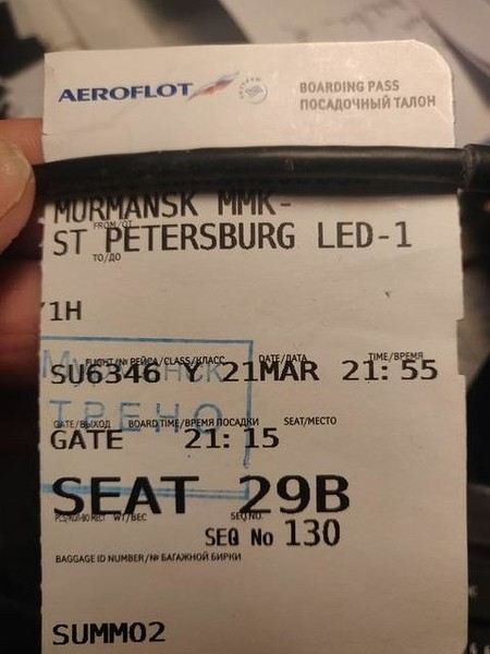
It’s the tail end of the northern lights season, and there were still crowds of Chinese tourists.
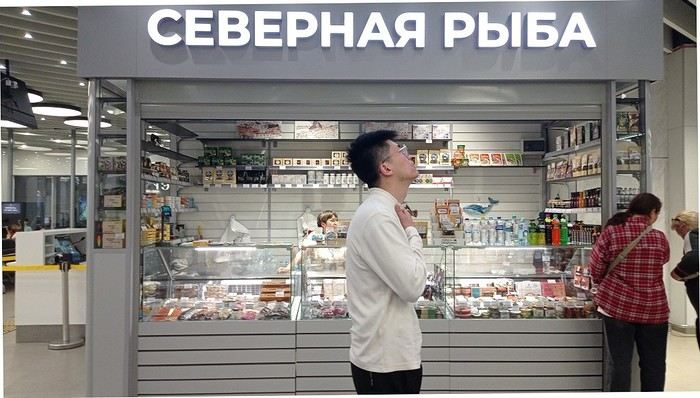
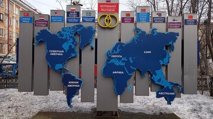
By the way, Murmansk is twinned with Harbin:
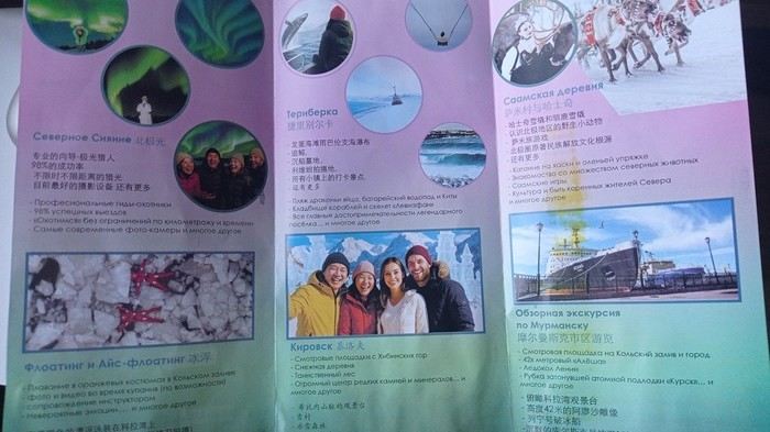
Chinese tourists are the largest foreign group, followed by Indians, then a mix of others from the Far East, Turks, Arabs, etc. Brochures are bilingual—Russian and Chinese:
============================
But let’s talk practical stuff. --
My domestic SIM card was restricted for SMS and internet for 24 hours. After that, if you want to keep using SMS, don’t turn off your phone—restarting triggers another 24-hour purgatory.
My Russian SIM cards (Megafon, MTS, Beeline) were activated as soon as I logged into their respective apps with my credentials.
Internet --
Telegram is heavily slowed down by authorities. To use it, you need to connect through proxy servers, which you load into the latest version of the app. Traffic is then rerouted internally within Telegram to servers outside Russia (Germany, Poland, Sweden, etc.). You can find these proxies on various channels. One is ChatVPN—check their website too.
For general internet use, like browsing the web, VPNs that work right now use the VLESS protocol. You can find several on Telegram by searching "VPN." A few free days, then payment in rubles or crypto.
Rozkomnadzor’s team are experts at this, so things can change. It’s a constant cat-and-mouse game.
Pskov is a special case. The city is near Estonia and has a large military base. Depending on NATO drone swarms launched from the Baltics, Wi-Fi can be completely suspended except for the most essential mobile apps. The drone swarms use the 4G network, and the powerful electronic jamming and drone suppression systems cause periods without Wi-Fi—including in hotels. Wired connections aren’t affected.
Borisoglebsk is the Russian border checkpoint after Kirkenes, on the road to Murmansk.
Kirkenes is a tiny town with a correspondingly small airport. Nothing has changed there: the minibuses to Murmansk wait on the right as you exit the airport. They’re synchronized with the two daily flights from Oslo—the SAS around 11:00 AM and Norwegian around 11:30 AM. They stop in Kirkenes at the corner of the Scandic for an hour, where other passengers can board, then head straight to the nearby border.
This is the least hassle Frontex/Schengen border. The Norwegian agent quickly scans your passport, and that’s it. No customs, since Norway is Schengen but not in the EU. On the Russian side, there’s a passport check and a quick customs inspection. All in all, crossing both the Norwegian and Russian checkpoints takes about 15 minutes.
A paper visa is required; e-visas aren’t accepted.
Two companies run the route: Avto Ekspress and Borodin: https://ae51.ru/routes/kirkenes-murmansk/ https://borodinbus.com/
The one-way fare is 5,500 ₽. You can either buy it online in rubles with a MIR card or make a formal reservation and pay in NOK cash to the driver. I took Borodin, and the price in NOK was much more expensive than in ₽.
=========================
On March 25, I left from Pskov via the Estonian border post at Luhaama. I spent three days in Murmansk, flew to St. Petersburg (SPB), stayed there for two days, then took an evening train to Pskov.
Since the end of February—and reportedly until the end of May—the Estonians have restricted the opening hours of the two border crossings near Pskov: Koidula (Pechory on the Russian side) and Luhaama (Izborsk on the Russian side). They’re closed at night between 7:00 PM and 7:00 AM. Right now, there’s a bus from Pskov at 7:00 AM to the border. It drops you off at the end of the road where truckers—many Kazakh and Serbian—are parked on the side. You finish the rest on foot to the barrier, where there’s a quick initial check for Ukrainian stamps in passports. Then you walk to the customs building, followed by passport control at the kiosk for motorists. After that, it’s a 500-meter walk to the Estonian checkpoint. At the moment, things seem calmer. Passport control is quick. The usual silly questions in English: "Where were you? Where are you going?" I just gave my most clueless smile: "Sorry, I don’t understand." Yeah, right—I don’t speak English, especially not at an Estonian border with a French passport. If they’re in a mood, though... A very quick bag inspection. Once you exit the Estonian post, walk to the bus stop sign by the road where another coach takes you to Riga.
The catch: in my case, last Wednesday, there were two passengers (Russians) with old Ukrainian stamps in their passports. The bus from the Estonian post to Riga was supposed to leave around 9:30 AM. We ended up leaving around noon after the two were grilled by the FSB. Since it was a weekday outside of holidays, the bus was half-empty. The fuller the bus and the more people with Ukrainian stamps, the worse the nightmare. Don’t book a same-day flight from Riga. I had a flight at 6:00 PM, so it worked out.
=============
The Kirkenes-Murmansk route is still clearly the easiest and fastest. But it’s not the most convenient since it’s way up north.
Next, I’d say the Gdansk-Kaliningrad route in the middle of the week. Avoid weekends and holiday departures/returns.
Avoid the Narva-Ivangorod route during Christmas, Easter, May 9, and *all* summer.
==============
About flights from Murmansk to St. Petersburg: prices are good. I bought my ticket the day before departure on Rossiya for 7,500 ₽, including 10 kg of luggage + a handbag.
It’s the tail end of the northern lights season, and there were still crowds of Chinese tourists.
By the way, Murmansk is twinned with Harbin:
Chinese tourists are the largest foreign group, followed by Indians, then a mix of others from the Far East, Turks, Arabs, etc. Brochures are bilingual—Russian and Chinese:
============================
But let’s talk practical stuff. --
My domestic SIM card was restricted for SMS and internet for 24 hours. After that, if you want to keep using SMS, don’t turn off your phone—restarting triggers another 24-hour purgatory.
My Russian SIM cards (Megafon, MTS, Beeline) were activated as soon as I logged into their respective apps with my credentials.
Internet --
Telegram is heavily slowed down by authorities. To use it, you need to connect through proxy servers, which you load into the latest version of the app. Traffic is then rerouted internally within Telegram to servers outside Russia (Germany, Poland, Sweden, etc.). You can find these proxies on various channels. One is ChatVPN—check their website too.
For general internet use, like browsing the web, VPNs that work right now use the VLESS protocol. You can find several on Telegram by searching "VPN." A few free days, then payment in rubles or crypto.
Rozkomnadzor’s team are experts at this, so things can change. It’s a constant cat-and-mouse game.
Pskov is a special case. The city is near Estonia and has a large military base. Depending on NATO drone swarms launched from the Baltics, Wi-Fi can be completely suspended except for the most essential mobile apps. The drone swarms use the 4G network, and the powerful electronic jamming and drone suppression systems cause periods without Wi-Fi—including in hotels. Wired connections aren’t affected.
From Mexico to the Wonderful Chiapas
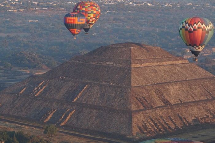
This one-month trip, from January 18 to February 17, 2026, allowed us to visit Mexico City and travel through the states of Puebla, Oaxaca, and Chiapas. We mainly used buses (ADO company) for medium and long distances and colectivos or taxis (or Uber) for shorter trips. Before leaving, I had contacted several people on the ground: Harry, a Vendéan settled in Oaxaca offering, among other things, discoveries of artisan villages or the Monte Albán site, and Oscar in Comitán de Domínguez. I’ll come back to our meeting with Oscar, who runs a local agency (CVL Travel Turismo Alternativo & Corre la voz) and owns a very pleasant hostel, a real highlight of our trip. Our journey took place in 8 stages on a loop starting from Mexico City. The connections between each were made by day or night buses depending on the trip duration. I had booked our seats in advance, either directly on the ADO company’s website or through booking platforms depending on the rates offered. Note that by planning ahead, I was able to benefit from very interesting "Early Booking" rates. There are several comfort classes. For all our trips, I had booked seats in Primera class buses, except for two in GL (Grand Luxe) class. The rates are very reasonable, and the buses turned out to be comfortable or even very comfortable (only the basic seat recline might surprise you).
Our itinerary and number of days per stage: Stage 1 – Mexico City: 4 days Stage 2 – Puebla: 2 days Stage 3 – Oaxaca: 4 days Stage 4 – San Agustinillo: 4 days Stage 5 – San Cristóbal de las Casas: 3 days Stage 6 – Comitán de Domínguez: 6 days Stage 7 – Palenque: 4 days Stage 8 – Mexico City: 2 days If I were to do it again, I’d remove one day from Palenque and add it either to Puebla or San Cristóbal to visit nearby sites or villages, or to San Agustinillo to enjoy one more day by the Pacific Ocean.
Stage 1: Mexico City (2,200 m / 9.2 million inhabitants) We arrived in the Mexican capital around 10:00 PM. The simplified customs process was very quick. After exchanging some money at the airport, we took a taxi to our youth hostel. We got around the capital on foot, of course, but also by metro. Signs are very rare, and we took the train in the wrong direction several times. After a few mistakes, we systematically asked on the platform if we were going the right way. The metro is very affordable. You need to get a rechargeable card (the Tarjeta de Movilidad Integrada) and top it up as needed. This card (less than 1 €) isn’t personal, so there’s no need to get one per person.
Mexico City: Day 1.

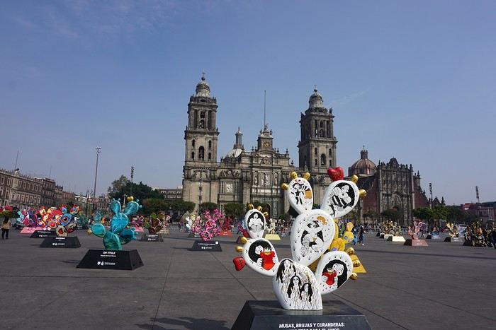
Visits and walks of the day (note: many museums are closed on Mondays): The Zócalo or Constitution Square: it’s one of the most beautiful, largest (195m x 240m), and oldest squares in the world. This is where Cortés decided to build the center of the new Spanish city on the site of the former Tenochtitlan market. Stones from the pyramids were used to pave the esplanade and build the surrounding colonial churches and buildings. During our visit, the huge square was covered with (resin) cacti, the theme of the temporary exhibition at the time. Indeed, temporary events or exhibitions take place here throughout the year. It’s also the endpoint for many protest marches.
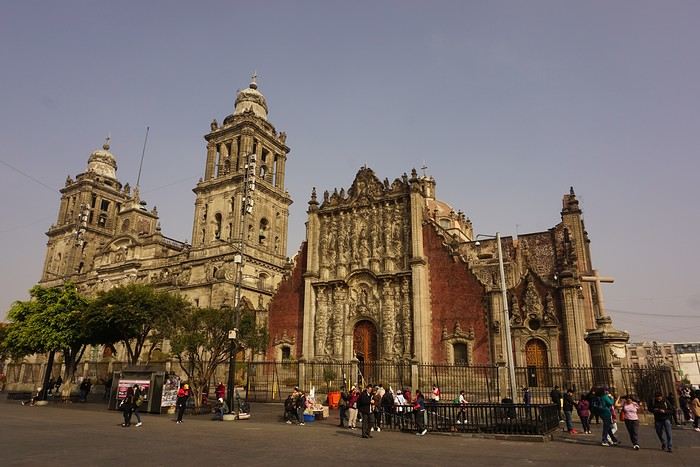
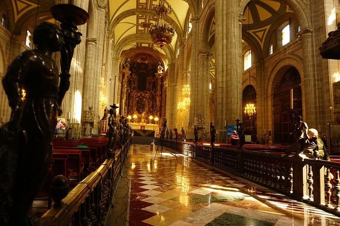


The cathedral: it’s sinking by one centimeter per year despite massive stabilization work (the collapse of many Mexican buildings—30 cm/year—is due to groundwater pumping). It was built starting in 1571 and completed in... 1813. The modest remains of the Templo Mayor (exterior view): they have high symbolic value, as this monument was the most important in the Mexica Empire.
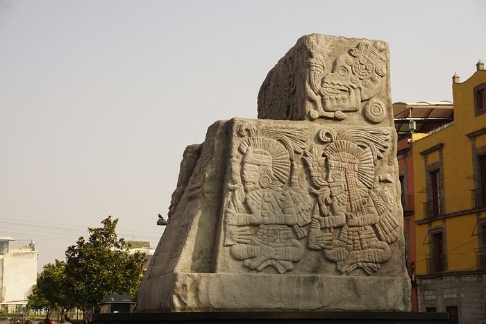 We then walked through the streets of the historic center to the Santísima Church, unfortunately closed for renovation work.
Next, we took the metro to visit one of Mexico’s most important pilgrimage sites: the Insigne y Nacional Basílicas de Santa María de Guadalupe, as well as the Capilla del Cerrito on the hill.
The first, dating from the colonial era, is really leaning a lot.
We then walked through the streets of the historic center to the Santísima Church, unfortunately closed for renovation work.
Next, we took the metro to visit one of Mexico’s most important pilgrimage sites: the Insigne y Nacional Basílicas de Santa María de Guadalupe, as well as the Capilla del Cerrito on the hill.
The first, dating from the colonial era, is really leaning a lot.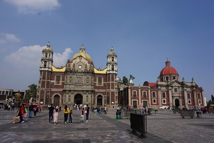
The second, shaped like a rotunda, is very impressive from the inside.
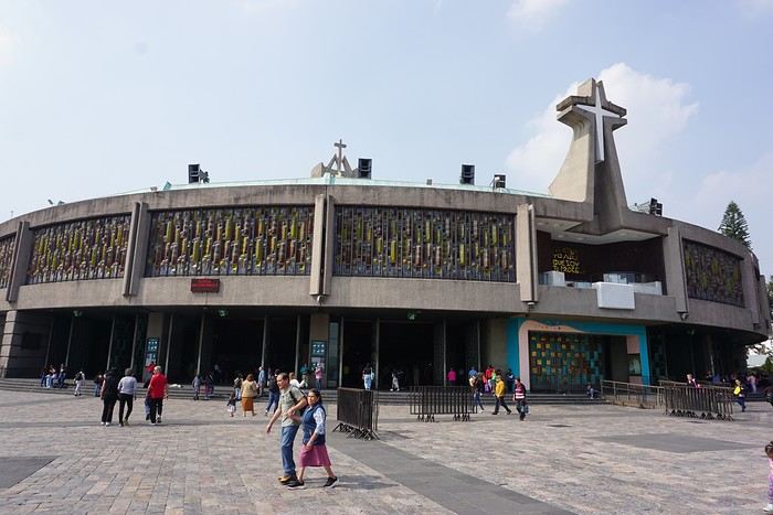
In the basement, there’s a sacred tunic where, in 1531, an image of the Virgin Mary is said to have appeared. A real mystery for scientists, the garment has never deteriorated since that date. Slow-moving conveyor belts allow pilgrims to admire it, preventing crowds from gathering in front of the image for hours. Well thought out!
 From the top of the Capilla del Cerrito, you get beautiful views of huge Mexico City.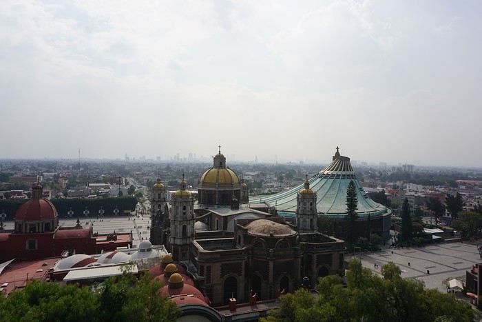
10 Days in Afghanistan with the Taliban
Hi, I’m not sure if this belongs here.
The videos aren’t mine—they’re from a YouTuber.
I find his trip mind-blowing and totally different from what we see on TV!
So far, two 1-hour-12-minute videos have been released, but there’ll be at least one more!
Some French journalists and politicians have been tearing him apart lately. At the same time, the guy put in insane work without any funding...
Personally, I’m really impressed by what he’s done...
Here are the links. Sorry if this feels like an ad, but I genuinely think his trip is great—and most importantly, judgment-free. The only other thing I’d seen from him was his trip to Transnistria.
I Lived 10 Days with the Taliban 🇦🇫
Under Taliban Sharia in Afghanistan 🇦🇫
I find his trip mind-blowing and totally different from what we see on TV!
So far, two 1-hour-12-minute videos have been released, but there’ll be at least one more!
Some French journalists and politicians have been tearing him apart lately. At the same time, the guy put in insane work without any funding...
Personally, I’m really impressed by what he’s done...
Here are the links. Sorry if this feels like an ad, but I genuinely think his trip is great—and most importantly, judgment-free. The only other thing I’d seen from him was his trip to Transnistria.
I Lived 10 Days with the Taliban 🇦🇫
Under Taliban Sharia in Afghanistan 🇦🇫
Texas, Louisiana, and a Touch of Florida
After five trips to the American West, we had planned to switch countries and continents to visit Turkey. However, by the time we made up our minds, flight ticket prices had nearly doubled, reaching 400 € for a round-trip ticket. A bit disappointed, I started looking at transatlantic flight prices and stumbled upon discounted tickets from Basel-Mulhouse to Dallas—at the same price as our tickets to Turkey!
No hesitation needed; we bought the five tickets for a total of 1,860 € excluding baggage!
From Fort Worth Airport, we had two options: - Head west on a loop through Texas, New Mexico, and southern Colorado - Head east to change the scenery and explore East Texas, Louisiana, with a possible detour into Florida.
The latter option won unanimously, so here we are, off to discover new states, mainly Louisiana and Texas.
One of the main post-COVID challenges is finding a reasonably priced car rental. After an initial booking around 1,300 €, we kept an eye on prices a few weeks before departure and managed to snag a better deal at around 900 € for a comfortable sedan.
Yes, this summer will also be a first: no 4x4, no camping, and plenty of restaurants!
As always, I’ve planned a packed itinerary, ready to adjust on the go. A few weeks before departure, we learned we’d be at full capacity—our eldest son, Maxime, got his first-year med school results. By finishing as a top admit, he avoided the mandatory July-August internship that would’ve kept him from joining us. Instead, he wrapped up his internship at the last minute the night before our big departure.
We’ll get to savor these special moments together.
The itinerary: Day 1 - 07/15: Fort Worth Day 2: Dallas Day 3: Jefferson - Caddo Lake Day 4: Black Bayou Lake - Natchez - Stanton Hall and Rosalie Mansion Day 5: St. Francisville - Rosedown Plantation - Cat Island Wildlife Refuge Day 6: Mobile - USS Alabama Battleship Memorial Park Day 7 - 8: Pensacola Beach Day 9: Bellingrath Gardens - New Orleans Day 10 - 11: New Orleans Day 12: Plantation Route Day 13: Jungle Gardens - Tabasco Factory - Vermilionville - Lake Martin Day 14: Baton Rouge - USS Kidd Day 15: Houma - Cajun Man's Swamp Tour Day 16: Galveston, Texas Day 17: Space Center Houston - Painted Churches Day 18: San Antonio Day 19: Texas Hill Country Day 20: Texas Hill Country and evening in San Antonio Day 21: Austin and Waco
Day 0 - 07/14: The departure timing isn’t exactly relaxing. On Thursday late afternoon, we hit the road to Alsace, aiming to drop off our two cockers with family before reaching the airport at 2 AM for a 3-hour power nap. Not exactly fresh, we arrive at the terminal looking for a British Airways counter. None in sight, so we try our luck at a United Airlines counter—who knows, maybe it’ll work out. And bingo! The agent checks us in. We didn’t quite understand why, but maybe there’s some agreement between airlines. For the first time, we’re traveling without checked baggage, so no extra fees. Not a huge feat, given the scorching temperatures awaiting us!
The connecting flight to London goes smoothly.
During the layover, liquid checks get stricter—now requiring small bottles to be in a pre-approved clear bag, with only one bag allowed per passenger. Normally, no big deal, but between deodorant, sunscreen, after-sun lotion, hand sanitizer, contact lens solution, etc., we spend 20 minutes optimizing the arrangement! When we finally succeed, one of the security staff bursts out laughing and congratulates us!
With our stomachs growling, we grab an American breakfast before browsing the airport shops.
We then discover our plane for the long-haul flight and are thrilled to see it’s an A380—a first for Laetitia, though the rest of the family experienced it during our winter getaway. Still just as impressive!
With a hint of uncertainty, we take off for the States—my third trip in barely 12 months. This time, no endless badlands, canyons, slot canyons, hoodoos, or brain rocks, but a journey through five states (Texas, Louisiana, a quick stop in Mississippi, Alabama, and the northwest tip of Florida), where we hope to soak up a unique vibe... with a packed schedule of diverse visits.
Arrival at Fort Worth Airport and customs go smoothly. Since we have no checked baggage, we’re first in line at the Dollar counter. In just 3 minutes, the formalities are done. We decline the Toll Pass, which I don’t think we’ll need based on my "calculations," and head to the Dollar parking lot, where an employee tells us we can pick any car we want!
There are about thirty cars waiting. Too many choices!
After last year’s mishap in Oakland, where our 4x4’s trunk was broken into, we’re looking for a sedan to hide our luggage this time. Unfortunately, there are none—only SUVs. We finally settle on a comfortable 7-seater Ford SUV with a massive trunk when set up for five.
On the road from Fort Worth to Dallas, we accidentally take a toll highway without realizing until it’s too late to exit. Let’s hope Dollar doesn’t charge us a week’s worth of their pricey Toll Pass for a $2 toll. We’ll see... In the meantime, Maxime sets up Google Maps to avoid toll roads.
Since it’s not too late, we stop by the nearest Walmart for groceries before checking into our hotel room for three nights in East Dallas suburb.
No hesitation needed; we bought the five tickets for a total of 1,860 € excluding baggage!
From Fort Worth Airport, we had two options: - Head west on a loop through Texas, New Mexico, and southern Colorado - Head east to change the scenery and explore East Texas, Louisiana, with a possible detour into Florida.
The latter option won unanimously, so here we are, off to discover new states, mainly Louisiana and Texas.
One of the main post-COVID challenges is finding a reasonably priced car rental. After an initial booking around 1,300 €, we kept an eye on prices a few weeks before departure and managed to snag a better deal at around 900 € for a comfortable sedan.
Yes, this summer will also be a first: no 4x4, no camping, and plenty of restaurants!
As always, I’ve planned a packed itinerary, ready to adjust on the go. A few weeks before departure, we learned we’d be at full capacity—our eldest son, Maxime, got his first-year med school results. By finishing as a top admit, he avoided the mandatory July-August internship that would’ve kept him from joining us. Instead, he wrapped up his internship at the last minute the night before our big departure.
We’ll get to savor these special moments together.
The itinerary: Day 1 - 07/15: Fort Worth Day 2: Dallas Day 3: Jefferson - Caddo Lake Day 4: Black Bayou Lake - Natchez - Stanton Hall and Rosalie Mansion Day 5: St. Francisville - Rosedown Plantation - Cat Island Wildlife Refuge Day 6: Mobile - USS Alabama Battleship Memorial Park Day 7 - 8: Pensacola Beach Day 9: Bellingrath Gardens - New Orleans Day 10 - 11: New Orleans Day 12: Plantation Route Day 13: Jungle Gardens - Tabasco Factory - Vermilionville - Lake Martin Day 14: Baton Rouge - USS Kidd Day 15: Houma - Cajun Man's Swamp Tour Day 16: Galveston, Texas Day 17: Space Center Houston - Painted Churches Day 18: San Antonio Day 19: Texas Hill Country Day 20: Texas Hill Country and evening in San Antonio Day 21: Austin and Waco
Day 0 - 07/14: The departure timing isn’t exactly relaxing. On Thursday late afternoon, we hit the road to Alsace, aiming to drop off our two cockers with family before reaching the airport at 2 AM for a 3-hour power nap. Not exactly fresh, we arrive at the terminal looking for a British Airways counter. None in sight, so we try our luck at a United Airlines counter—who knows, maybe it’ll work out. And bingo! The agent checks us in. We didn’t quite understand why, but maybe there’s some agreement between airlines. For the first time, we’re traveling without checked baggage, so no extra fees. Not a huge feat, given the scorching temperatures awaiting us!
The connecting flight to London goes smoothly.
During the layover, liquid checks get stricter—now requiring small bottles to be in a pre-approved clear bag, with only one bag allowed per passenger. Normally, no big deal, but between deodorant, sunscreen, after-sun lotion, hand sanitizer, contact lens solution, etc., we spend 20 minutes optimizing the arrangement! When we finally succeed, one of the security staff bursts out laughing and congratulates us!
With our stomachs growling, we grab an American breakfast before browsing the airport shops.
We then discover our plane for the long-haul flight and are thrilled to see it’s an A380—a first for Laetitia, though the rest of the family experienced it during our winter getaway. Still just as impressive!
With a hint of uncertainty, we take off for the States—my third trip in barely 12 months. This time, no endless badlands, canyons, slot canyons, hoodoos, or brain rocks, but a journey through five states (Texas, Louisiana, a quick stop in Mississippi, Alabama, and the northwest tip of Florida), where we hope to soak up a unique vibe... with a packed schedule of diverse visits.
Arrival at Fort Worth Airport and customs go smoothly. Since we have no checked baggage, we’re first in line at the Dollar counter. In just 3 minutes, the formalities are done. We decline the Toll Pass, which I don’t think we’ll need based on my "calculations," and head to the Dollar parking lot, where an employee tells us we can pick any car we want!
There are about thirty cars waiting. Too many choices!
After last year’s mishap in Oakland, where our 4x4’s trunk was broken into, we’re looking for a sedan to hide our luggage this time. Unfortunately, there are none—only SUVs. We finally settle on a comfortable 7-seater Ford SUV with a massive trunk when set up for five.
On the road from Fort Worth to Dallas, we accidentally take a toll highway without realizing until it’s too late to exit. Let’s hope Dollar doesn’t charge us a week’s worth of their pricey Toll Pass for a $2 toll. We’ll see... In the meantime, Maxime sets up Google Maps to avoid toll roads.
Since it’s not too late, we stop by the nearest Walmart for groceries before checking into our hotel room for three nights in East Dallas suburb.
Botswana avril 2021... faut bien rêver
Hello Tous,
J'hésite entre deux circuits, d'une durée de 14 jours chacun.
L'un faisant Kasane - Nata - Khubu Island - CKGR : Leopard Pan, Piper Pan, Xaxa Camp, Bape Camp - Kutse 5Molose et Moreswe) - Khama Rhino Sanctuary - Francistown - Nata - Kasane.
L'autre: Kasane - Gweta - Ghanzi - Kaa Secteur (Swartpan, Gnus Gnus, Zushwa) - CKGR (Xade - Piper Pan Leopard Pan) - Khubu Island - Kasane
Qu'en pensez-vous ? Ca fait beaucoup de route mais j'aimerais retour dans le Kalahari et la voiture est basée à Kasane.
Dans l'attente de vos commentaires, beaux rêves 🙂
J'hésite entre deux circuits, d'une durée de 14 jours chacun.
L'un faisant Kasane - Nata - Khubu Island - CKGR : Leopard Pan, Piper Pan, Xaxa Camp, Bape Camp - Kutse 5Molose et Moreswe) - Khama Rhino Sanctuary - Francistown - Nata - Kasane.
L'autre: Kasane - Gweta - Ghanzi - Kaa Secteur (Swartpan, Gnus Gnus, Zushwa) - CKGR (Xade - Piper Pan Leopard Pan) - Khubu Island - Kasane
Qu'en pensez-vous ? Ca fait beaucoup de route mais j'aimerais retour dans le Kalahari et la voiture est basée à Kasane.
Dans l'attente de vos commentaires, beaux rêves 🙂
Et si on se montrait nos petits films de voyages?
Hello,
Sur la même idée que claudio de la Faverges dans un autre post, je me disais, dans l'attente de pouvoir reprendre la route et d'effectuer de grandes bambées, et si on se montrait nos films de voyages ?
J'emmène toujours une petite caméra avec moi, je film la route suivant mes envies et quand c'est possible, histoire d'avoir à la fin un souvenir, une trace, chaque périple est une belle histoire personnelle, avec ses bons moments et ses galères.
https://www.youtube.com/watch?v=Qi5ykYxewDQ
https://www.youtube.com/watch?v=DLsrmWhKw5E
https://www.youtube.com/watch?v=xshtkcTyg_g
Gilles
Sur la même idée que claudio de la Faverges dans un autre post, je me disais, dans l'attente de pouvoir reprendre la route et d'effectuer de grandes bambées, et si on se montrait nos films de voyages ?
J'emmène toujours une petite caméra avec moi, je film la route suivant mes envies et quand c'est possible, histoire d'avoir à la fin un souvenir, une trace, chaque périple est une belle histoire personnelle, avec ses bons moments et ses galères.
https://www.youtube.com/watch?v=Qi5ykYxewDQ
https://www.youtube.com/watch?v=DLsrmWhKw5E
https://www.youtube.com/watch?v=xshtkcTyg_g
Gilles
Arriver avec un drone à l'aéroport de Tachkent
Bonjour,
Il est interdit, sauf autorisation, d'apporter ou d'utiliser un drone en Ouzbékistan. Plusieurs voyageurs ont eu leur drone saisit et/ou détruit à la douane, notamment les frontières terrestres. Mais j'ai lu dans quelques forums anglophones qu'en déclarant spontanément son drone à l'arrivée à l'aéroport de Tachkent, il était peut-être possible de le laisser "en consigne" à la douane et de le récupérer en repartant. Quelqu'un a t-il un retour d'expérience sur le sujet ? En effet on va passer d'abord 2 semaines au Kirghisztan où le drone est autorisé et j'aimerais bien trouver une solution pour ne pas avoir de problème en arrivant en Ouzbékistan.
Merci de vos retours.
Il est interdit, sauf autorisation, d'apporter ou d'utiliser un drone en Ouzbékistan. Plusieurs voyageurs ont eu leur drone saisit et/ou détruit à la douane, notamment les frontières terrestres. Mais j'ai lu dans quelques forums anglophones qu'en déclarant spontanément son drone à l'arrivée à l'aéroport de Tachkent, il était peut-être possible de le laisser "en consigne" à la douane et de le récupérer en repartant. Quelqu'un a t-il un retour d'expérience sur le sujet ? En effet on va passer d'abord 2 semaines au Kirghisztan où le drone est autorisé et j'aimerais bien trouver une solution pour ne pas avoir de problème en arrivant en Ouzbékistan.
Merci de vos retours.
Retour du Sud algérien en février 2019
Bonjour à tous,
Cela faisait un moment qu’une envie de découvrir le Sahara nous trottait dans la tête, mais plus le côté dunes avec rochers que désert de cailloux. Malheureusement les conditions sécuritaires n’étaient pas réunies et nous ne voulions pas y aller seuls. A l’origine je « surveillais » plus particulièrement l’Ennedi au Nord du Tchad.
C’est en Ouganda, lors d’une discussion avec Mayrig que le projet a commencé à émerger. Elle aussi voulait retourner dans le Sahara (qu’ils connaissent puisqu’ils ont habité en Algérie). Elle avait même commencé à constituer un petit groupe (avec 2/3 amis à eux) et elle avait jeté son dévolu sur la région de Djanet où se trouve une zone magnifique qu’on nomme la Tadrart Rouge où les dunes rouges partent à l’assaut des rochers noirs. C’est aussi un secteur avec de nombreuses peintures rupestres attestant de la présence d’animaux (éléphant, girafes, lions, etc, ..) .... il y a fort fort longtemps. Va pour le Sud Algérie, nous nous joindrons à eux, d’autant plus que le gouvernement Algérien venait de rouvrir la zone aux touristes.
Après recherches nous avons sélectionné une agence avec laquelle nous avons élaboré notre itinéraire de 9 jours. Nous souhaitions une version avec déplacements en 4x4 et petites balades. Pour le choix de l’agence, ce qui nous avait paru déterminant, c’est que ce soit des Touaregs qui gèrent le voyage sur place. Ils sont chez eux et tant qu’on est avec eux on ne risque rien, c’est ce que j’avais conclu de mes recherches.
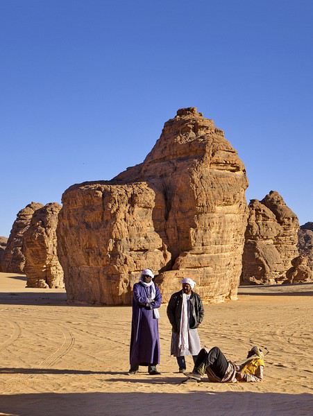
Au niveau démarches ce n’est pas tout simple : Au maximum 3 mois avant le départ, l’agence sur place doit déposer l’itinéraire au ministère (je ne sais pas lequel) avec tous nos papiers. Une fois que notre circuit est accepté, nous recevons une première autorisation (durée de réponse variable, pour nous quasiment un mois). Ensuite il faut aller au consulat pour faire une demande de visa en joignant à la demande cette autorisation (là une semaine a suffi).
La période : février est un bon mois pour découvrir cette région, il ne fait pas encore trop chaud et le ciel est bleu. D’après le guide sur place, la meilleure période va de décembre (après les pluies) à fin février, ensuite le ciel se voile légèrement à cause des vents de sable.
Au niveau vol : Djanet est bien desservie par Air Algérie, ce sera donc Frankfurt – Alger – Djanet (et pour nos amis Nice – Paris – Alger – Djanet).
Au niveau organisation :
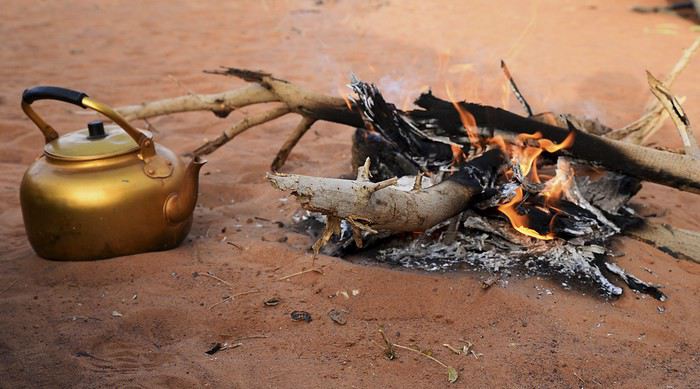
Nous serons accompagnés de 2 chauffeurs (2 véhicules 4x4) et d’un cuisinier. Normalement, on dort à la belle étoile mais comme il faisait assez froid (surtout au début) et il y avait pas mal de vent, nous avons préféré dormir en tente légère (et légèrement cassée également).
Comme d'habitude voici le lien vers le blog avec plus de photos
Cela faisait un moment qu’une envie de découvrir le Sahara nous trottait dans la tête, mais plus le côté dunes avec rochers que désert de cailloux. Malheureusement les conditions sécuritaires n’étaient pas réunies et nous ne voulions pas y aller seuls. A l’origine je « surveillais » plus particulièrement l’Ennedi au Nord du Tchad.
C’est en Ouganda, lors d’une discussion avec Mayrig que le projet a commencé à émerger. Elle aussi voulait retourner dans le Sahara (qu’ils connaissent puisqu’ils ont habité en Algérie). Elle avait même commencé à constituer un petit groupe (avec 2/3 amis à eux) et elle avait jeté son dévolu sur la région de Djanet où se trouve une zone magnifique qu’on nomme la Tadrart Rouge où les dunes rouges partent à l’assaut des rochers noirs. C’est aussi un secteur avec de nombreuses peintures rupestres attestant de la présence d’animaux (éléphant, girafes, lions, etc, ..) .... il y a fort fort longtemps. Va pour le Sud Algérie, nous nous joindrons à eux, d’autant plus que le gouvernement Algérien venait de rouvrir la zone aux touristes.
Après recherches nous avons sélectionné une agence avec laquelle nous avons élaboré notre itinéraire de 9 jours. Nous souhaitions une version avec déplacements en 4x4 et petites balades. Pour le choix de l’agence, ce qui nous avait paru déterminant, c’est que ce soit des Touaregs qui gèrent le voyage sur place. Ils sont chez eux et tant qu’on est avec eux on ne risque rien, c’est ce que j’avais conclu de mes recherches.
Au niveau démarches ce n’est pas tout simple : Au maximum 3 mois avant le départ, l’agence sur place doit déposer l’itinéraire au ministère (je ne sais pas lequel) avec tous nos papiers. Une fois que notre circuit est accepté, nous recevons une première autorisation (durée de réponse variable, pour nous quasiment un mois). Ensuite il faut aller au consulat pour faire une demande de visa en joignant à la demande cette autorisation (là une semaine a suffi).
La période : février est un bon mois pour découvrir cette région, il ne fait pas encore trop chaud et le ciel est bleu. D’après le guide sur place, la meilleure période va de décembre (après les pluies) à fin février, ensuite le ciel se voile légèrement à cause des vents de sable.
Au niveau vol : Djanet est bien desservie par Air Algérie, ce sera donc Frankfurt – Alger – Djanet (et pour nos amis Nice – Paris – Alger – Djanet).
Au niveau organisation :
Nous serons accompagnés de 2 chauffeurs (2 véhicules 4x4) et d’un cuisinier. Normalement, on dort à la belle étoile mais comme il faisait assez froid (surtout au début) et il y avait pas mal de vent, nous avons préféré dormir en tente légère (et légèrement cassée également).
Comme d'habitude voici le lien vers le blog avec plus de photos
Hippie Trail, les chemins de Katmandou
Bonjour à tous,
J'ai lu que le "hippie trail" avait fini avec la révolution iranienne (et l'invasion russe en Afghanistan) en 1979. Mais est-ce que cela veut dire que l'Iran ne fournissait plus de visas aux touristes indépendants dans les années 80 ? Ou juste que les compagnies qui proposaient des trips en bus (cf. Magic Bus) n'étaient plus autorisés à entreprendre ce voyage (ou n'osaient plus, ou n'avaient plus assez de clients courageux) ?
Merci d'avance pour vos réponses, c'est un sujet qui m'intéresse beaucoup, mes parents s'étant rencontrés sur cette route vers cette époque-là... 😛
J'ai lu que le "hippie trail" avait fini avec la révolution iranienne (et l'invasion russe en Afghanistan) en 1979. Mais est-ce que cela veut dire que l'Iran ne fournissait plus de visas aux touristes indépendants dans les années 80 ? Ou juste que les compagnies qui proposaient des trips en bus (cf. Magic Bus) n'étaient plus autorisés à entreprendre ce voyage (ou n'osaient plus, ou n'avaient plus assez de clients courageux) ?
Merci d'avance pour vos réponses, c'est un sujet qui m'intéresse beaucoup, mes parents s'étant rencontrés sur cette route vers cette époque-là... 😛
Discussion autour du thème du mois de mars 2019: "Le ciel dans tous ses états"
Pour toutes discussions etc, c'est bien ici
Pour poster les photos participant au concours, c'est là:
https://voyageforum.com/v.f?post=9342735;live=1;
Augmentation des frais de visa pour l'Inde
Encore une fois l'Inde augmente ses frais de visa. Une demande de visa (toutes catégories confondues) coûte désormais 25 € de plus, soit 130 € pour les touristes et 190 € pour les voyageurs d'affaires.
Lire la suite...
Carnet de route Oman février 2019
Bonjour à tous,
je suis toujours à Oman, mais comme les liaisons sont bonnes, je vais essayer de faire mon carnet au fur et à mesure.
Pas de photos, elles sont sur mon site ICI (euh en fait cela sera un peu plus tard ….. et mieux rédigé surement)
Comme d'habitude dans mes voyages, et comme beaucoup j'adore m'occuper de tout, donc Madame ne sait pas trop, d'ailleurs c'est son cadeau de Noël.
Les hôtels (pas de camping, pas trop notre truc) sont réservés depuis la France, le 4*4 aussi.
J'ai eu la chance d'avoir pu acheter un OOR en France dans le bon coin, de quelqu'un qui rentrait juste. Pratiquement neuf, le pied !
Bon je commence :
Dimanche 17 C’est le départ ! 3h45 on ferme la maison et direction aéroport. Un arrêt au parking extérieur et c’est à 4h45que l’on arrive pour l’embarquement pour un vol à 7h. On pense être cool, mais quelle surprise de voir une queue énorme pour les choses administratives. KLM/Air France sont vraiment spécialistes. Personne ailleurs, ah si en fait beaucoup plus de guichets ouverts ailleurs. Vol Lyon Amsterdam sans soucis avec des prestations low-cost, mais bon on est à l’heure. Deux heures d’attente à Shipol et décollage vers Damman en Arabie Saoudite. Le plan de vol annoncé sur les écrans change ! Au lieu de survoler le Liban, la Syrie et l’Irak, on passe au sud vers l’Egypte puis l’Arabie Saoudite. Curieux, j'aurai tant aimé survolé ces pays accueillants en ce moment !! Une belle vue sur le désert donne envie de voir du désert…. Patience Escale technique à Damman, où les seuls à descendre sont des hommes venant travailler en AS et une famille que j’imagine être saoudienne. Ensuite petit vol vers Mascate, arrivée à l’heure. Après le train train habituel, l’immigration, avec le visa pris par internet, on gagne du temps, récupération des bagages, puis la voiture. Chez Europcar, pas d’attente, on nous propose donc un toyota fortuner. C’est un 4*4, donc l’essentiel. Je branche le GPS et hop c’est parti, euh non pas vraiment car il ne trouve pas mon adresse. Petit moment de panique, je décide d’y aller au nez (j’avais en tête un peu le plan de la ville). Après un arrêt et un reboostage du bébé, hop, il fonctionne et on se trouve à 5 min de l’hôtel. Accueil sympa, douche et dodo car depuis 3h00 ce matin même s’il n’est que 21h en France, ça fait beaucoup !
Le + : On y est !! Le - : KLM/Air France, cela devient du low cost
Dimanche 17 C’est le départ ! 3h45 on ferme la maison et direction aéroport. Un arrêt au parking extérieur et c’est à 4h45que l’on arrive pour l’embarquement pour un vol à 7h. On pense être cool, mais quelle surprise de voir une queue énorme pour les choses administratives. KLM/Air France sont vraiment spécialistes. Personne ailleurs, ah si en fait beaucoup plus de guichets ouverts ailleurs. Vol Lyon Amsterdam sans soucis avec des prestations low-cost, mais bon on est à l’heure. Deux heures d’attente à Shipol et décollage vers Damman en Arabie Saoudite. Le plan de vol annoncé sur les écrans change ! Au lieu de survoler le Liban, la Syrie et l’Irak, on passe au sud vers l’Egypte puis l’Arabie Saoudite. Curieux, j'aurai tant aimé survolé ces pays accueillants en ce moment !! Une belle vue sur le désert donne envie de voir du désert…. Patience Escale technique à Damman, où les seuls à descendre sont des hommes venant travailler en AS et une famille que j’imagine être saoudienne. Ensuite petit vol vers Mascate, arrivée à l’heure. Après le train train habituel, l’immigration, avec le visa pris par internet, on gagne du temps, récupération des bagages, puis la voiture. Chez Europcar, pas d’attente, on nous propose donc un toyota fortuner. C’est un 4*4, donc l’essentiel. Je branche le GPS et hop c’est parti, euh non pas vraiment car il ne trouve pas mon adresse. Petit moment de panique, je décide d’y aller au nez (j’avais en tête un peu le plan de la ville). Après un arrêt et un reboostage du bébé, hop, il fonctionne et on se trouve à 5 min de l’hôtel. Accueil sympa, douche et dodo car depuis 3h00 ce matin même s’il n’est que 21h en France, ça fait beaucoup !
Le + : On y est !! Le - : KLM/Air France, cela devient du low cost
Voyager en hiver à vélo (France)
Bonjour à vous tous.
Lors de mes prochaines vacances, du 10 au 20 février, j'aimerai entreprendre un voyage en vélo en partant de Caen et à destination de Nantes puis continuer en bretagne en fonction de la vitesse à laquelle j'avancerai. J'ai déjà fait un voyage l'été dernier, il s'agissait de mon premier. Or, j'aimerai avoir quelques conseils sur le matériel nécessaire en hiver. J'aimerai utiliser warmshower ainsi que m'arrêter chez des amis pour dormir, mais je vais aussi, très certainement, être dans la nécessité de dormir en extérieur (tente).
Bien évidemment, les températures sont beaucoup moins agréables que l'été ... ihi et pour faire de bonnes nuits j'aimerai avoir quelques conseils pour l'achat de matériel (duvet, vêtements chauds, gants, bonnets etc.) qui soient confortables.
J'aimerai ne pas avoir à dépenser trop d'argent, notamment pour le duvet (même si il semblerait que le prix monte assez vite) et la matelas isolant du sol (ou si vous avez d'autres idées pour le couchage).
Merci pour vos conseils !
Lors de mes prochaines vacances, du 10 au 20 février, j'aimerai entreprendre un voyage en vélo en partant de Caen et à destination de Nantes puis continuer en bretagne en fonction de la vitesse à laquelle j'avancerai. J'ai déjà fait un voyage l'été dernier, il s'agissait de mon premier. Or, j'aimerai avoir quelques conseils sur le matériel nécessaire en hiver. J'aimerai utiliser warmshower ainsi que m'arrêter chez des amis pour dormir, mais je vais aussi, très certainement, être dans la nécessité de dormir en extérieur (tente).
Bien évidemment, les températures sont beaucoup moins agréables que l'été ... ihi et pour faire de bonnes nuits j'aimerai avoir quelques conseils pour l'achat de matériel (duvet, vêtements chauds, gants, bonnets etc.) qui soient confortables.
J'aimerai ne pas avoir à dépenser trop d'argent, notamment pour le duvet (même si il semblerait que le prix monte assez vite) et la matelas isolant du sol (ou si vous avez d'autres idées pour le couchage).
Merci pour vos conseils !
Concours Photo du mois de janvier 2019: "Que la montagne est belle"
Bonjour à tous .
Tout d’abord, pas d’inquiétude, je ne fais pas d’insomnie post réveillon, il est bientôt 10h de la terrasse de la Homestay à Udaipur d’ou je vous écris, le soleil commence à réchauffer la terre et les oiseaux s’en donne à cœur joie .... Bon j’avoue, de la brume il n’y en a pas que dans la plaine, mon crâne l’est encore un peu ....
Permettez-moi de vous souhaiter à tous mes meilleurs vœux pour cette nouvelle année, qu’elle soit remplie de bonnes choses pour tous, et surtout de beaux voyages !
Vous l’avez compris, puisque ma victoire m’octroie l’honneur de démarrer cette nouvelle année par un nouveau concours, j’ai décidé, et j’avoue que la vidéo postée par notre ami obeo de la chanson de Jean Ferrat m’a inspiré, de faire preuve d’un peu de chauvinisme...
Le thème du concours sera donc « Que la montagne est belle » . En hiver ou en été, de chez nous ou d’ailleurs, je veux voir des sommets !! Et pour corser un peu le tout, et comme c’est moi qui décide 😉, il faudra qu’on retrouve, à l’instar du thème de Solene, une présence humaine dans votre photo Essayons d'éviter tout de même la file de votre dernière remontée mécanique à Chamonix, mais il faut que l’humain soit présent sur votre cliché.
Le concours démarre donc right now, et la date limite pour poster vos photos est fixée au vendredi 18 à 23.59 Vote du samedi 19 0h01 jusqu’au samedi 26 janvier 23h59 et j’essaierais d’etre au rendez-vous le 27 ( 28 au plus tard, promis)
Comme d’hab, 3 photos maxi, numérotées et légendés, si possible dans 3 messages .
Pour les discussions, hors sujet et vidéos, c’est là : https://voyageforum.com/discussion/discussion-autour-theme-mois-janvier-2019-que-montagne-est-belle-d9264140/
Et pour le diaporama, si quelq’un peut m’aider ....😕
Voilà, je crois j’ai tout bon, enfin, j’ai essayé... Alors, à vous de nous faire grimper au sommet ! Namaste !
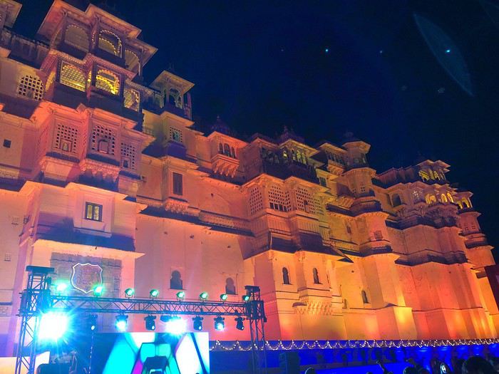
Ça, c’etait mon réveillon et croyez-moi, ça a envoyé du bois ! 😊
Permettez-moi de vous souhaiter à tous mes meilleurs vœux pour cette nouvelle année, qu’elle soit remplie de bonnes choses pour tous, et surtout de beaux voyages !
Vous l’avez compris, puisque ma victoire m’octroie l’honneur de démarrer cette nouvelle année par un nouveau concours, j’ai décidé, et j’avoue que la vidéo postée par notre ami obeo de la chanson de Jean Ferrat m’a inspiré, de faire preuve d’un peu de chauvinisme...
Le thème du concours sera donc « Que la montagne est belle » . En hiver ou en été, de chez nous ou d’ailleurs, je veux voir des sommets !! Et pour corser un peu le tout, et comme c’est moi qui décide 😉, il faudra qu’on retrouve, à l’instar du thème de Solene, une présence humaine dans votre photo Essayons d'éviter tout de même la file de votre dernière remontée mécanique à Chamonix, mais il faut que l’humain soit présent sur votre cliché.
Le concours démarre donc right now, et la date limite pour poster vos photos est fixée au vendredi 18 à 23.59 Vote du samedi 19 0h01 jusqu’au samedi 26 janvier 23h59 et j’essaierais d’etre au rendez-vous le 27 ( 28 au plus tard, promis)
Comme d’hab, 3 photos maxi, numérotées et légendés, si possible dans 3 messages .
Pour les discussions, hors sujet et vidéos, c’est là : https://voyageforum.com/discussion/discussion-autour-theme-mois-janvier-2019-que-montagne-est-belle-d9264140/
Et pour le diaporama, si quelq’un peut m’aider ....😕
Voilà, je crois j’ai tout bon, enfin, j’ai essayé... Alors, à vous de nous faire grimper au sommet ! Namaste !
Ça, c’etait mon réveillon et croyez-moi, ça a envoyé du bois ! 😊
Retour des Marquises... mais pas que...
Hello tous,
Profitant de cette trêve de fin d'année, j'ai écrit le carnet de notre dernier voyage en Polynésie Française.
La version avec photos etoutetout estici 😎
Genèse Une envie de faire un voyage différent de ceux qu’on a l’habitude de faire, plus contemplatif, plus des vacances/voyage, dépaysant tout de même aussi bien sur le plan humain que paysages. Avec de la plongée sous-marine et un peu de randonnée. Bref vous aurez compris qu’il n’y a qu’une île qui puisse correspondre à de tels critères. Naturellement c’est la Polynésie mythique qui m’est venue en premier à l’esprit. Mais avant de me décider j’ai tout de même sillonné « virtuellement » une bonne partie du pacifique. La Nouvelle Calédonie m’a aussi attiré, donc je mets de côté pour un prochain voyage. Lors de ces recherches ce sont les Marquises et les Tuamotu qui m’ont attiré le plus, pour le côté « bout du monde », hors normes.
Comment se déplacer En avion bien sûr ! ... si on compte les vol internationaux et les escales, nous atterrirons et décollerons 11 fois !.
Vol internationaux avec Air Tahiti Nui et vols internes avec Air Tahiti "tout court". En fait ce sont 2 compagnies différentes. Air Tahiti propose des "pass", nous prendrons celui des Marquises.
Entre Papeete et Moorea ce sera un ferry.
Sur les îles: Ua Pou: nous serons pris en charge par la pension. Nuku Hiva: nous louerons un petit Suzuki Jimmy. Hiva Oa: là aussi ce sera un véhicule, un Suzuki Vitara. Moorea: toujours un véhicule, une Twingo. Fakarave: en partie pris en charge par les locaux (pension, snack, club de plongée) et en partie en vélo.
Bref on aura utilisé, avec grand plaisir, à peu près tous les moyens de transports possibles afin de garder une certaine "indépendance".
Tout a été réservé directement par mail.
Les logements C'est les pensions de famille qui nous ont paru être le meilleur moyen de découvrir la Polynésie et les Polynésiens. C'est donc vers elles que nous nous sommes tournés à chaque fois que possible, pour notre plus grand plaisir. Je les ai réservé directement par mail.
Ravitaillement Pour une fois ce n'est pas d'essence que je vais parler, mais de gastronomie. Nous nous sommes régalés, pour ne pas dire "gavé" de poisson cru, du poisson au lait de coco, de mahi mahi, de fruits, que de la nourriture qu'on adore. Le tout arrosé d'une bonne Hinano.
On n'a pas eu de problème pour retirer des Francs Pacifiques sur les îles, en plus les euros sont acceptés quasiment partout, les Polynésiens pouvant sans problème déposer des euros sur leur compte.
L'itinéraire En Polynésie le premier « sport » de tout voyageur est d’essayer de combiner de façon optimale les vols inter îles … et il y a de quoi y passer un bon moment.
Je suis donc parti sur un parcours : Tahiti (Papeete) Marquises avec Ua Pou, Nuku Hiva et Hiva Oa Comme il faut repasser par Papeete, autant rajouter une escale rapide à Mooréa Pour finir par Fakarava dans les Tuamotu.
Les MARQUISES UA POU : 3 nuits NUKU HIVA : 3 nuits HIVA OA : 2 nuits
Iles Sur le VENT MOOREA : 1 nuit PAPEETE : 1 nuit
Les TUAMOTU FAKARAVA : 3 nuits
Profitant de cette trêve de fin d'année, j'ai écrit le carnet de notre dernier voyage en Polynésie Française.
La version avec photos etoutetout estici 😎
Genèse Une envie de faire un voyage différent de ceux qu’on a l’habitude de faire, plus contemplatif, plus des vacances/voyage, dépaysant tout de même aussi bien sur le plan humain que paysages. Avec de la plongée sous-marine et un peu de randonnée. Bref vous aurez compris qu’il n’y a qu’une île qui puisse correspondre à de tels critères. Naturellement c’est la Polynésie mythique qui m’est venue en premier à l’esprit. Mais avant de me décider j’ai tout de même sillonné « virtuellement » une bonne partie du pacifique. La Nouvelle Calédonie m’a aussi attiré, donc je mets de côté pour un prochain voyage. Lors de ces recherches ce sont les Marquises et les Tuamotu qui m’ont attiré le plus, pour le côté « bout du monde », hors normes.
Comment se déplacer En avion bien sûr ! ... si on compte les vol internationaux et les escales, nous atterrirons et décollerons 11 fois !.
Vol internationaux avec Air Tahiti Nui et vols internes avec Air Tahiti "tout court". En fait ce sont 2 compagnies différentes. Air Tahiti propose des "pass", nous prendrons celui des Marquises.
Entre Papeete et Moorea ce sera un ferry.
Sur les îles: Ua Pou: nous serons pris en charge par la pension. Nuku Hiva: nous louerons un petit Suzuki Jimmy. Hiva Oa: là aussi ce sera un véhicule, un Suzuki Vitara. Moorea: toujours un véhicule, une Twingo. Fakarave: en partie pris en charge par les locaux (pension, snack, club de plongée) et en partie en vélo.
Bref on aura utilisé, avec grand plaisir, à peu près tous les moyens de transports possibles afin de garder une certaine "indépendance".
Tout a été réservé directement par mail.
Les logements C'est les pensions de famille qui nous ont paru être le meilleur moyen de découvrir la Polynésie et les Polynésiens. C'est donc vers elles que nous nous sommes tournés à chaque fois que possible, pour notre plus grand plaisir. Je les ai réservé directement par mail.
Ravitaillement Pour une fois ce n'est pas d'essence que je vais parler, mais de gastronomie. Nous nous sommes régalés, pour ne pas dire "gavé" de poisson cru, du poisson au lait de coco, de mahi mahi, de fruits, que de la nourriture qu'on adore. Le tout arrosé d'une bonne Hinano.
On n'a pas eu de problème pour retirer des Francs Pacifiques sur les îles, en plus les euros sont acceptés quasiment partout, les Polynésiens pouvant sans problème déposer des euros sur leur compte.
L'itinéraire En Polynésie le premier « sport » de tout voyageur est d’essayer de combiner de façon optimale les vols inter îles … et il y a de quoi y passer un bon moment.
Je suis donc parti sur un parcours : Tahiti (Papeete) Marquises avec Ua Pou, Nuku Hiva et Hiva Oa Comme il faut repasser par Papeete, autant rajouter une escale rapide à Mooréa Pour finir par Fakarava dans les Tuamotu.
Les MARQUISES UA POU : 3 nuits NUKU HIVA : 3 nuits HIVA OA : 2 nuits
Iles Sur le VENT MOOREA : 1 nuit PAPEETE : 1 nuit
Les TUAMOTU FAKARAVA : 3 nuits
Quelle île thaïlandaise choisir quand on est avec un enfant?
Bonjour à tous,
Nous partons avec mon mari et notre fille de 18 mois en Thailande en février 2019. Nous restons 15 jours sur place. Nous comptons passer 1/2j à Bangkok en arrivant pour voir comment notre fille s'acclimate et on refera 1/2j à la fin de notre voyage avant de reprendre l'avion. Nous allons aller par avion à Chang Maï 4/5j et faire ensuite une île pour se relaxer et plonger. Quelle(s) île(s) nous conseillerez-vous en sachant qu'avec un bébé, on n'est pas en mode grosse teuf ? Des amis nous ont parlé de Koh Tao, Koh Lipe et Koh Chang. On a 7j pour les îles, donc on pourrait aller sur deux îles (Koh Samoui/Koh Tao par ex.) Pour Koh lipe, je crois qu'il y a pas mal de temps de traversée pour rejoindre l'île...
On est un peu perdu avec toutes les choix possibles donc un peu d'aide et de conseils nous faciliterait bien la tâche.
Merci d'avance, Aurore
Nous partons avec mon mari et notre fille de 18 mois en Thailande en février 2019. Nous restons 15 jours sur place. Nous comptons passer 1/2j à Bangkok en arrivant pour voir comment notre fille s'acclimate et on refera 1/2j à la fin de notre voyage avant de reprendre l'avion. Nous allons aller par avion à Chang Maï 4/5j et faire ensuite une île pour se relaxer et plonger. Quelle(s) île(s) nous conseillerez-vous en sachant qu'avec un bébé, on n'est pas en mode grosse teuf ? Des amis nous ont parlé de Koh Tao, Koh Lipe et Koh Chang. On a 7j pour les îles, donc on pourrait aller sur deux îles (Koh Samoui/Koh Tao par ex.) Pour Koh lipe, je crois qu'il y a pas mal de temps de traversée pour rejoindre l'île...
On est un peu perdu avec toutes les choix possibles donc un peu d'aide et de conseils nous faciliterait bien la tâche.
Merci d'avance, Aurore
Voyage camping-car jusqu'à Irkoutsk et croisière sur le lac Baïkal
En 2019 j'envisage de me rendre en camping car jusqu'à Irkoutsk et d'effectuer une croisière de 6 jours sur le lac Baïkal.
Je prévois de suivre le même itinéraire et les mêmes étapes que le Paris Pékin pour la partie Russe.
Je sollicite les camping caristes qui auraient déjà effectué ce parcours pour m'indiquer les sites de bivouac (adresses, coordonnées gps , etc)qu'ils ont utilisés sur le parcours.
Remerciements par avance
moutarin 38
Kayaking in Greenland - Disko Bay: Circumnavigation of Arve Princess Island
After two rather rainy kayaking experiences in Alaska at the end of summer in recent years, we chose a slightly drier destination for this late August 2018: the west coast of Greenland. The temperature will certainly be a bit colder, especially at this time of year, but we’re betting on a beautiful end to the season. According to temperature charts, it should be around 5 to 10°C with a few night frosts. The tundra will already have its autumn colors, and by the end of the trip, we might be lucky enough to see the northern lights when the nights get darker.
We’re setting off as a group of three in two inflatable double-seater kayaks (Gumotex) brought from France. The plan is to spend two weeks circumnavigating Arve Princess Island, located north of Ilulissat in Disko Bay, with a possible boat drop-off at the southern tip of the island.
This seems like a fairly classic route in the area—we found several descriptions online (thanks to the authors). With their help and Google Earth, we identified all potential campsites and entered their coordinates into a GPS. The western part of the island, facing the bay, seems ideal for whale watching, while the more rugged eastern side offers access to several glacial walls. We’re somewhat familiar with the area from two winter expeditions on skis and pulkas.
Plus, the commitment is limited due to the island’s proximity to several small villages, including Qeqertaq, Oqaatsut, and even Ilulissat. In fact, we saw fishing boats almost every day. The distance suits us well: 200 kilometers in 16 full days on site, which should leave some leeway in case of bad weather or for hiking.
We booked our flights in June with Air Greenland to Ilulissat for the last week of August and the first week of September. On both the outbound and return trips, we stayed overnight in Copenhagen. The France-Copenhagen flight was with Air France.
We were allowed 3 x 20 kg in the hold. Each kayak with its accessories fits into a 20 kg bag; the last hold bag is for shared gear: tent, stoves, dry bags… We only brought 1.5 kg of semolina for food. In the end, we had 61 kg of gear, and no excess baggage was charged.
Individual gear (clothes and sleeping bags…) was distributed in the cabin luggage.
For the boat transfer, we contacted an agency: Blue Jay, which gave us a number to call upon arrival.
Day 0: Wednesday, August 22 Departure day. After work, I drove from Gap to Marseille’s Marignane Airport for the first leg of the trip to Copenhagen. I enjoyed the rather mild local temperatures: 35°C in the shade. After a layover in Paris, I arrived at the Copenhagen hotel, located two train stops from the airport, where my companions were already settled. No issues—everyone was on time with their luggage.
Day 1 The flight to Greenland was at 9 AM. We had a layover in Kangerlussuaq, where we changed planes, then stopped in Aasiaat before reaching Ilulissat Airport at 3 PM under beautiful sunshine.
We called Blue Jay for the boat transfer: they could take us to the island as early as 6 PM; otherwise, we’d have to wait until the next day. That left us 3 hours to prepare our gear and, most importantly, do our shopping for the two-week trip—it seemed tight, but we gave it a shot.
A quick taxi ride took us to Pisiffik, where we easily found everything we needed: bread, butter, cheese, cold cuts, rice, pasta, jam, muesli… There was no C fuel or methylated spirits for the stoves, but this time we knew the trick: at Stark, a bit uphill from the town, we found the precious liquids. Two hours later, we filled our dry bags and containers with our purchases, and by 5:30 PM, we met Klaus, the Blue Jay manager, directly at the port.
The vacation seemed to truly begin as we sped by boat through the icebergs toward Arve Princess Island. Forty-five minutes later, we spotted a beach lined with rocks where Klaus dropped us off quickly (he had another transfer to make right after).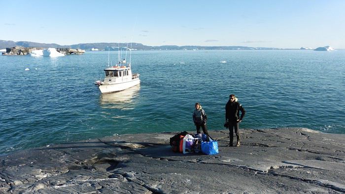
Here we were on the island, in the middle of nowhere, with all our luggage and food to organize, the tent to set up, and the kayaks to inflate—just 10 hours after leaving the Copenhagen hotel. We got to work, bothered by the flies. Despite our head nets, it was barely tolerable—there were so many of them. They swarmed by the dozens into every bag we opened. It was quite mild: 10°C.
Everything was ready by evening, and we were very happy to have completed all these transfers (planes and boat in a single day) as we slipped into our sleeping bags.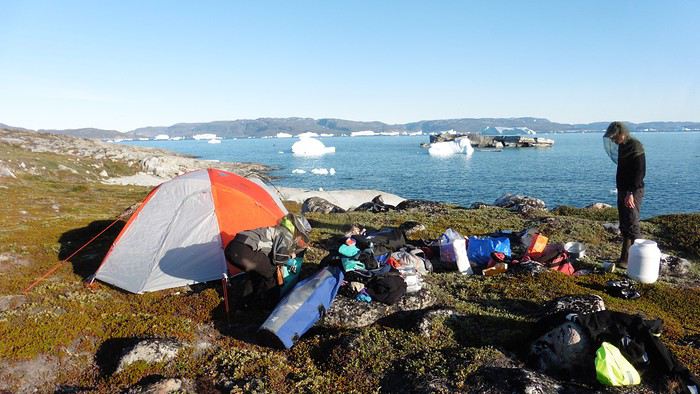
During the night, the wind picked up, and we went out several times to check the tent and kayak anchors. We noticed how bright it was—it was still quite twilight even at 1 AM.
Day 2 5:30 AM wake-up—the south wind was still strong, but since we were heading north, we decided to give it a try anyway.
This was also the moment we loaded the kayaks: since there were only three of us for two double-seater kayaks, we filled the hatch of one kayak, which allowed us to fit all our food. It would have been very difficult if there had been four of us for two kayaks.
Finally, we set off north along the western coast of the island. The conditions were far from ideal—the sea was rough, and the kayaks had a lot of wind resistance. But the main problem was the spray skirt: the gear on deck weighed it down, and the skirt kept coming off… We’d have to deal with it. Barely underway, and whales were already breaking the surface—it was our first time seeing them, and we were very impressed. Too bad the wind didn’t allow for longer contemplation; stopping paddling was impossible with such strong gusts.
We passed a few headlands and even considered stopping due to the conditions. To find some semblance of shelter, we had to hug the coast closely without cutting across the numerous bays, which significantly lengthened the journey. But as the morning went on, the wind died down, and the sea calmed. We spotted several whales and our first seals. It was almost pleasant during the picnic break. By late afternoon, we reached Kangerup Sarqâ Bay, where we had identified a great campsite with a very large beach and a river. But the wind had shifted—it was now coming from the north, making the last hour difficult due to fatigue and headwinds.
The campsite was ideal and beautiful, facing numerous icebergs grounded in the bay.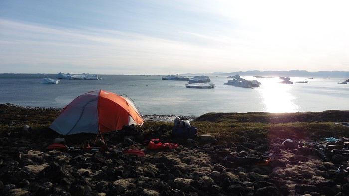
The GPS alerted us to another major drawback of inflatable kayaks: their slowness. It took us 7.5 hours of actual paddling (excluding breaks) to cover 28 km, averaging 3.7 km/h—somewhat disappointing. But we knew this before leaving, and once again, we’d have to make do!
Day 3 Surprise: at 6 AM wake-up, it was raining, foggy, with a south wind, and the sea was choppy even in the bay. It seemed wise to skip paddling, even though stopping on the second day was tough on morale. We went back to sleep, especially since the travel fatigue and the harsh conditions of the previous day had taken their toll.
At 11 AM, the navigation conditions weren’t any better—at the ends of the bay, we saw huge waves crashing onto the rocks, and giving up for the day became obvious. However, the rain had stopped, so we set off for a hike along the large lake bordering the bay. The wind hadn’t let up, and it was quite cold.
The tundra was starting to take on its autumn colors, and the contrast between the white lichens and the red vegetation was stunning. At the lake, we took out the fishing rods and quickly caught two beautiful Arctic char over 50 cm long.
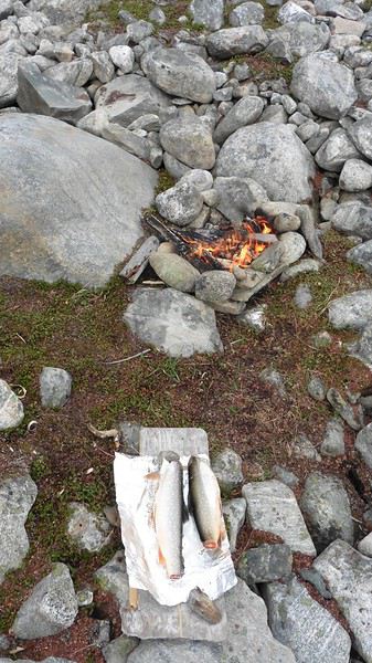
As the afternoon wore on, the sun seemed closer. Along the beach, we gathered driftwood (mostly old planks) to cook our catch in foil over a fire. Eating our own food in such a beautiful place next to a good fire was comforting after the day’s setback.
In the middle of the night, an Arctic fox entered the tent’s rear awning. It seemed barely intimidated when we shooed it away with loud shouts and then with stones.
Day 4 6:15 AM wake-up—3°C. We were on the water by 8 AM. The wind had dropped significantly, but the sea was shrouded in fog, and it was very cold in these damp conditions.
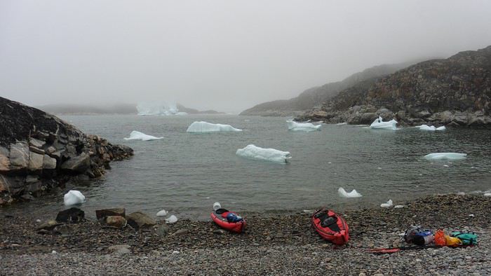
We passed the bay’s headland, Kangea, and headed toward the abandoned village of Agpat. The atmosphere was very austere—we hugged black rocks in fog that limited visibility to 50 meters, revealing large icebergs as we went.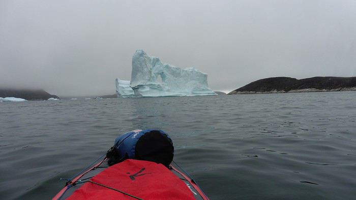
Suddenly, the water’s surface stirred in front of my kayak, and a huge gray back emerged from the sea. The collision was inevitable, but the whale seemed to understand and dove immediately, passing under the kayak and resurfacing a few meters away. I felt the kayak rock in the white foam and quickly paddled to escape the turbulence. What an emotion!
A light wind began to clear the fog, and the sun made beautiful appearances. Despite the cold, we stopped to visit the abandoned village, which left a strange impression. All the houses were still in good condition and wide open—some must have been very spacious in their time. We went back to sea, and in front of the large Kaangerdluk Bay, we hesitated—the headwind was strong, and large waves split the water. The next beach, from the island of Nua where we stopped to think, was over 8 km away. It was barely 2 PM, but caution led us to stop here for the day. We had covered 12 km—exactly the distance needed to stay on schedule. The afternoon was spent hiking on the island’s hills and gathering mussels and wood.
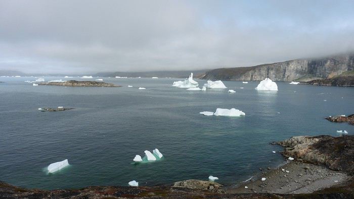
In the evening, we cooked these large Greenlandic mussels over a wood fire and savored them under the beautiful evening light. The weather was now fine, but the thermometer read -5°C in the sun…
Day 5 Bright sunshine, a glassy sea, and -8°C at 6 AM. Everything was green for setting off, even if putting on damp kayaking gear was a bit unpleasant in the cold. It was the first time we’d paddled on a flat sea since the start of the trip, and our average speed increased slightly.
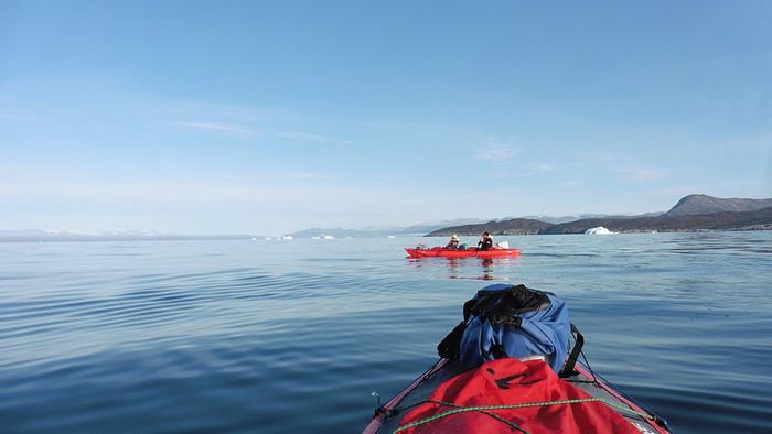
We entered the Smallesund Strait, marking the end of the island’s west coast. We were close to the large Torssukatak Fjord, where two glaciers flow. The access pass to the fjord was very narrow, and numerous ice chunks blocked access to the beaches. The wind had picked up and was now hitting us head-on (again). Just before entering the fjord, we landed on a steep beach made of large pebbles on Oqaitsut Island. It was very cold with the wind, and moving forward became difficult. We decided to stop for the day both because of the conditions and because the next campsite was far away, given how rugged the fjord was.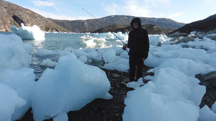
We eventually found a flat spot for the tent despite the steep slope. Even with the wind, the weather was beautiful, and we set off on foot for the northeastern cape of the island, overlooking the fjord. The view was far-reaching and exceptional—up close, the large fjord filled with ice and its steep granite cliffs, and in the distance, the ice cap and glacial walls.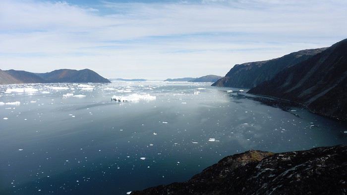
We spotted the village of Qeqertaq, whose network we could pick up, allowing us to check the weather forecast, which was rather good. While securing the kayaks in the evening, I noticed the strange behavior of one kayak at the end of the stage was due to the loss of the skeg—impossible to know where it detached. We’d have to do without it.
Day 6 Still that icy headwind from the northeast. We set off anyway for a long stage to reach the large pass connecting the Torssukatak and Ata Fjords.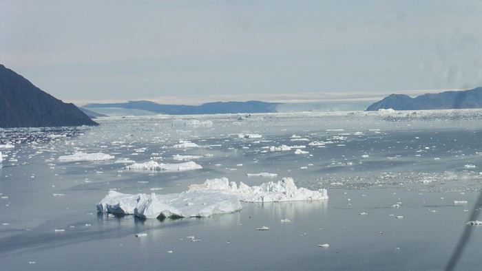
We advanced laboriously along the high cliffs of the fjord’s southern shore. They faced due north and blocked the sun. We felt the cold and dampness of the rock. It was really cold, especially in the extremities. We picnicked on the western cape of Qeqertakavasak Island. The cold didn’t allow us to stop for more than 20 minutes… But the wind dropped, and the sea was now very smooth. It was heavily cluttered with ice between the icebergs and old pack ice. The goal was to reach the large rocky promontory of Anapnuna, wedged between the Kujatdleq and Kangilerngata Glaciers, but the ice made progress difficult. We stopped to gain height on a small island and spot a passage of open water, but all we saw was white—passing seemed impossible. The currents were very complex, and entire sections of ice were being swept in one direction and then another at an impressive speed.
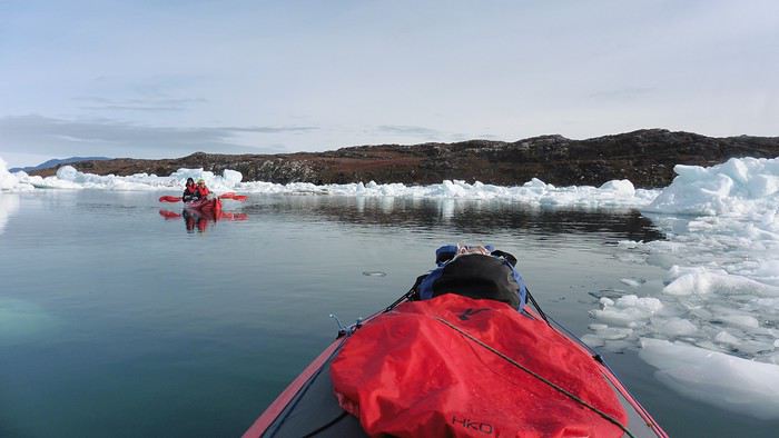
We wandered through this labyrinth until landing on a beach on the small island of Takissut, where we set up camp, exhausted from the 30 km covered and the vigilance required by the abundance of ice. The place was sublime under the evening sun—we were surrounded by ice and mountains, with the Kangilerngata Glacier in the distance. The summer contrasts were striking between the water, icebergs, sky, and flaming tundra—all colors were represented. Absolute calm reigned.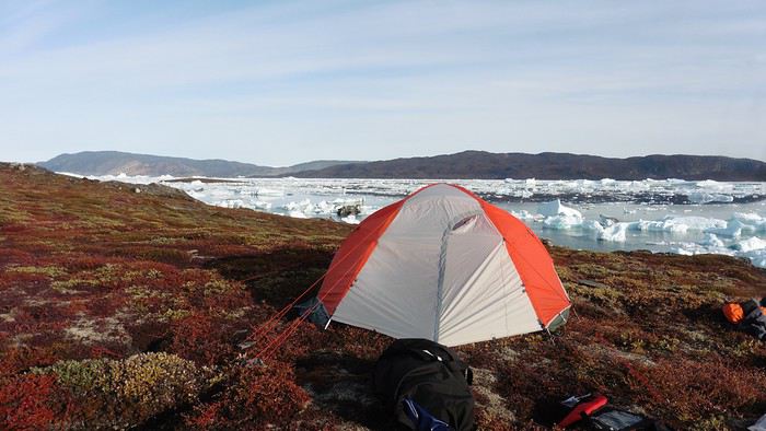
The lack of drinking water at this spot wasn’t too much of a constraint: as soon as we arrived on the beach, we placed containers under the icebergs stranded in the intertidal zone. They were all full by the time we finished setting up.
Day 7 We had to change our plans: we wouldn’t reach the rocky promontory, too well protected by the ice. We set off under the sun for Igdluluarssuit Island. Although we had spotted a passage just before launching, we quickly found ourselves surrounded by ice. It was everywhere, and finding water to paddle became complicated. We tried to force our way in every direction, even retracing our steps. Everything moved at an impressive speed—we were in the middle of a whirlpool of ice.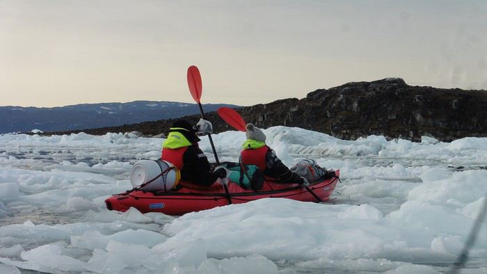
The tension rose, and each boat had its share of big scares. I was trapped against ice floes that dragged me toward an iceberg—the pressure on the kayak was enormous; it was going to capsize or puncture! But with a few strong strokes and paddling against the ice, I managed to free myself from the trap. Barely 10 minutes later, my companions were sandwiched perpendicularly between two icebergs that were closing in. The situation was desperate—the kayak was bending and twisting more and more, but with some strong paddle strokes, it finally freed itself. After these particularly unpleasant moments, we were completely blocked. The drifting ice floes had tightened, and the kayaks were no longer even in the water… The only solution: wait with the kayaks on these floes, which were too thin to walk on (even though we didn’t try). Within minutes, the situation cleared—a waterway opened, and we rushed into it. We paddled with one goal: find a larger pool of water. After going back and forth, our path took shape—we had to force the passage several times, attacking the ice directly with the kayaks, and finally, we escaped the worst of the labyrinth. We reached land on the west side of the island and saw that the rest would be easier. To reach the island, we just had to cross the Arsiviup Ikera Strait, which was lightly cluttered. We reached the eastern cape of the island, ideal for camping, even though we had only paddled for 3 hours. We set up camp and hiked to the island’s summit, which overlooks the entire pass and the glaciers.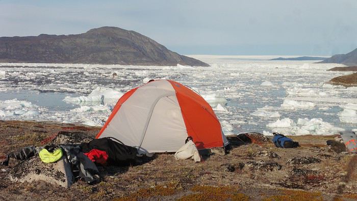
Everything was magnificent, no matter the direction. At 2 PM, we were at the summit—the beauty of the place and the picnic facing the glacier in the sun without wind made us forget the near-disaster from a few hours earlier. It would be impossible to approach the glacier by kayak, but from our summit on foot, it seemed so close, and contemplating it safely on solid ground was a great moment.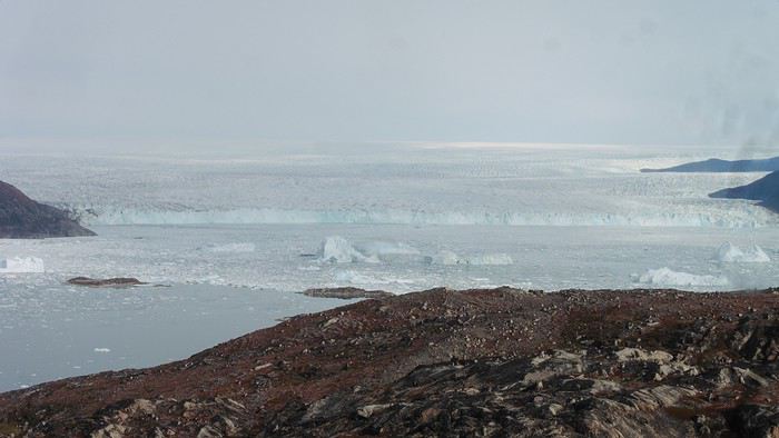
The pass was incredibly complex—everything was in motion, and an impassable passage could become open water within minutes. We were delighted when we returned to camp. A slightly lost whale among the ice accompanied us along the shore. The place was truly beautiful, but the temperature dropped again under the clear sky, preventing us from eating outside.
Day 8 Clear and cold at wake-up: -9°C. The sea had frozen in many places. We hesitated about the rest of the trip—should we start heading back to Ilulissat or linger in the pass, especially to approach the Eqi Glacier? After the incidents of the previous day, we decided to think carefully and paddled to the southern cape of our island to check the ice conditions toward Eqi. The weather had clouded over in the meantime, and the sky was quite gray. At the cape, we spotted the glacier’s wall, still 15 km away.
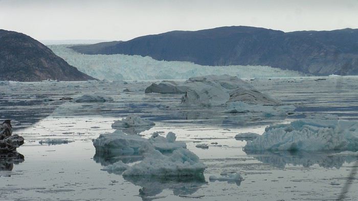
The fjord was quite cluttered, but it seemed passable. However, there was no guarantee the view would be much better 1 km from the glacier than 15 km away, especially since the front was quite active and therefore dangerous. We decided to head south without passing by the glacier. The cold temperatures encountered in the pass also motivated us to move away from the glaciers and the ice cap. We navigated under a threatening sky but without wind. The kayaks cut through the thin layer of ice on the surface with a crinkling paper sound. We reached the Ata campsite in the late afternoon after 5 hours of rowing without a single break…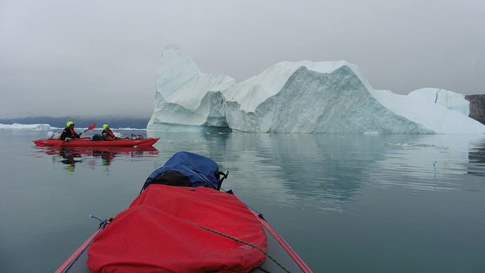
The wind had picked up, and we discovered a nice surprise: a refuge with a table and a comfortable bench lined with mattresses. Facing the worsening weather, we settled in comfortably. The kerosene stove was too complex for our three brains—we couldn’t get it started, too bad, as it was 0°C inside. The rest of the afternoon was spent fishing in the large lake, where we landed a beautiful Arctic char, more than enough for three. A good night’s sleep without the risk of foxes or the sound of a tent shaking in the wind.
Day 9 6 AM wake-up to the sound of rain hitting the cabin. The decision was made looking out the window—wind, rain, and fog obscured the sea: we went back to sleep.
New wake-up, and the rain had stopped—we could go out and stock up on fish. We set off on foot toward the lake, following its western shore. It was very overcast, and the wind encouraged us to keep moving. We made our way to a smaller lake at the end of the large one, where we caught a huge Arctic char. A small clearing brightened the picnic, and we headed back to our cabin.
This 20 km hike kept us busy all day: walking on slippery scree and the micro-relief of the peat bogs took time.
Day 10 The sky was clear, but a light south wind made paddling intense. We set off southeast to reach the opposite shore of the fjord. It was very cold, and it was impossible to stop paddling for even a moment without immediately losing ground due to the wind. We crossed the Kangerluarsuk Fjord. I recognized the cape I had reached on skis in the winter of 2017. We found a nice campsite on the southern shore of the fjord: Uiartag. It wasn’t even noon, but facing this headwind, we preferred to stop here rather than exhaust ourselves for a few extra kilometers. Like the previous ones, this campsite was very comfortable: the ground was covered with a thick layer of lichens and mosses, very pleasant to lie on.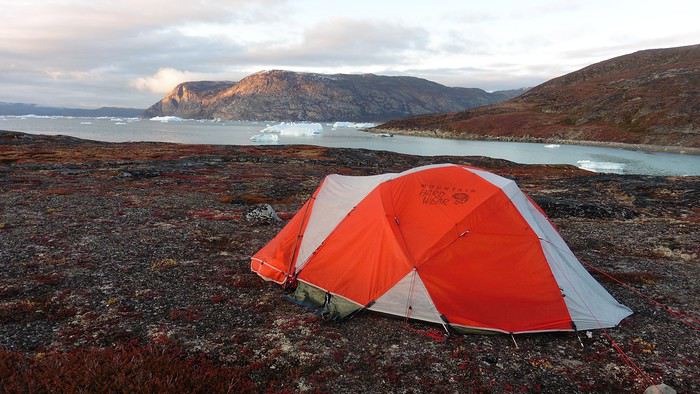
We set off on a hike to the heights of the cape, where the weather alternated between large clearings and snow showers. We noticed the loss of the thermometer, poorly attached to the backpack. On the way back, in the small bay of our beach, a whale swam calmly 10 meters from the shore—a beautiful surprise.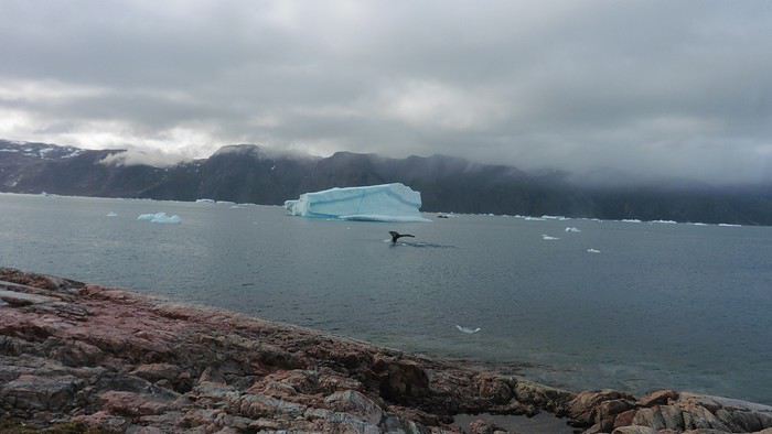
The sky cleared completely, and the temperature dropped as night approached.
We’re setting off as a group of three in two inflatable double-seater kayaks (Gumotex) brought from France. The plan is to spend two weeks circumnavigating Arve Princess Island, located north of Ilulissat in Disko Bay, with a possible boat drop-off at the southern tip of the island.
This seems like a fairly classic route in the area—we found several descriptions online (thanks to the authors). With their help and Google Earth, we identified all potential campsites and entered their coordinates into a GPS. The western part of the island, facing the bay, seems ideal for whale watching, while the more rugged eastern side offers access to several glacial walls. We’re somewhat familiar with the area from two winter expeditions on skis and pulkas.
Plus, the commitment is limited due to the island’s proximity to several small villages, including Qeqertaq, Oqaatsut, and even Ilulissat. In fact, we saw fishing boats almost every day. The distance suits us well: 200 kilometers in 16 full days on site, which should leave some leeway in case of bad weather or for hiking.
We booked our flights in June with Air Greenland to Ilulissat for the last week of August and the first week of September. On both the outbound and return trips, we stayed overnight in Copenhagen. The France-Copenhagen flight was with Air France.
We were allowed 3 x 20 kg in the hold. Each kayak with its accessories fits into a 20 kg bag; the last hold bag is for shared gear: tent, stoves, dry bags… We only brought 1.5 kg of semolina for food. In the end, we had 61 kg of gear, and no excess baggage was charged.
Individual gear (clothes and sleeping bags…) was distributed in the cabin luggage.
For the boat transfer, we contacted an agency: Blue Jay, which gave us a number to call upon arrival.
Day 0: Wednesday, August 22 Departure day. After work, I drove from Gap to Marseille’s Marignane Airport for the first leg of the trip to Copenhagen. I enjoyed the rather mild local temperatures: 35°C in the shade. After a layover in Paris, I arrived at the Copenhagen hotel, located two train stops from the airport, where my companions were already settled. No issues—everyone was on time with their luggage.
Day 1 The flight to Greenland was at 9 AM. We had a layover in Kangerlussuaq, where we changed planes, then stopped in Aasiaat before reaching Ilulissat Airport at 3 PM under beautiful sunshine.
We called Blue Jay for the boat transfer: they could take us to the island as early as 6 PM; otherwise, we’d have to wait until the next day. That left us 3 hours to prepare our gear and, most importantly, do our shopping for the two-week trip—it seemed tight, but we gave it a shot.
A quick taxi ride took us to Pisiffik, where we easily found everything we needed: bread, butter, cheese, cold cuts, rice, pasta, jam, muesli… There was no C fuel or methylated spirits for the stoves, but this time we knew the trick: at Stark, a bit uphill from the town, we found the precious liquids. Two hours later, we filled our dry bags and containers with our purchases, and by 5:30 PM, we met Klaus, the Blue Jay manager, directly at the port.
The vacation seemed to truly begin as we sped by boat through the icebergs toward Arve Princess Island. Forty-five minutes later, we spotted a beach lined with rocks where Klaus dropped us off quickly (he had another transfer to make right after).
Here we were on the island, in the middle of nowhere, with all our luggage and food to organize, the tent to set up, and the kayaks to inflate—just 10 hours after leaving the Copenhagen hotel. We got to work, bothered by the flies. Despite our head nets, it was barely tolerable—there were so many of them. They swarmed by the dozens into every bag we opened. It was quite mild: 10°C.
Everything was ready by evening, and we were very happy to have completed all these transfers (planes and boat in a single day) as we slipped into our sleeping bags.
During the night, the wind picked up, and we went out several times to check the tent and kayak anchors. We noticed how bright it was—it was still quite twilight even at 1 AM.
Day 2 5:30 AM wake-up—the south wind was still strong, but since we were heading north, we decided to give it a try anyway.
This was also the moment we loaded the kayaks: since there were only three of us for two double-seater kayaks, we filled the hatch of one kayak, which allowed us to fit all our food. It would have been very difficult if there had been four of us for two kayaks.
Finally, we set off north along the western coast of the island. The conditions were far from ideal—the sea was rough, and the kayaks had a lot of wind resistance. But the main problem was the spray skirt: the gear on deck weighed it down, and the skirt kept coming off… We’d have to deal with it. Barely underway, and whales were already breaking the surface—it was our first time seeing them, and we were very impressed. Too bad the wind didn’t allow for longer contemplation; stopping paddling was impossible with such strong gusts.
We passed a few headlands and even considered stopping due to the conditions. To find some semblance of shelter, we had to hug the coast closely without cutting across the numerous bays, which significantly lengthened the journey. But as the morning went on, the wind died down, and the sea calmed. We spotted several whales and our first seals. It was almost pleasant during the picnic break. By late afternoon, we reached Kangerup Sarqâ Bay, where we had identified a great campsite with a very large beach and a river. But the wind had shifted—it was now coming from the north, making the last hour difficult due to fatigue and headwinds.
The campsite was ideal and beautiful, facing numerous icebergs grounded in the bay.
The GPS alerted us to another major drawback of inflatable kayaks: their slowness. It took us 7.5 hours of actual paddling (excluding breaks) to cover 28 km, averaging 3.7 km/h—somewhat disappointing. But we knew this before leaving, and once again, we’d have to make do!
Day 3 Surprise: at 6 AM wake-up, it was raining, foggy, with a south wind, and the sea was choppy even in the bay. It seemed wise to skip paddling, even though stopping on the second day was tough on morale. We went back to sleep, especially since the travel fatigue and the harsh conditions of the previous day had taken their toll.
At 11 AM, the navigation conditions weren’t any better—at the ends of the bay, we saw huge waves crashing onto the rocks, and giving up for the day became obvious. However, the rain had stopped, so we set off for a hike along the large lake bordering the bay. The wind hadn’t let up, and it was quite cold.
The tundra was starting to take on its autumn colors, and the contrast between the white lichens and the red vegetation was stunning. At the lake, we took out the fishing rods and quickly caught two beautiful Arctic char over 50 cm long.
As the afternoon wore on, the sun seemed closer. Along the beach, we gathered driftwood (mostly old planks) to cook our catch in foil over a fire. Eating our own food in such a beautiful place next to a good fire was comforting after the day’s setback.
In the middle of the night, an Arctic fox entered the tent’s rear awning. It seemed barely intimidated when we shooed it away with loud shouts and then with stones.
Day 4 6:15 AM wake-up—3°C. We were on the water by 8 AM. The wind had dropped significantly, but the sea was shrouded in fog, and it was very cold in these damp conditions.
We passed the bay’s headland, Kangea, and headed toward the abandoned village of Agpat. The atmosphere was very austere—we hugged black rocks in fog that limited visibility to 50 meters, revealing large icebergs as we went.
Suddenly, the water’s surface stirred in front of my kayak, and a huge gray back emerged from the sea. The collision was inevitable, but the whale seemed to understand and dove immediately, passing under the kayak and resurfacing a few meters away. I felt the kayak rock in the white foam and quickly paddled to escape the turbulence. What an emotion!
A light wind began to clear the fog, and the sun made beautiful appearances. Despite the cold, we stopped to visit the abandoned village, which left a strange impression. All the houses were still in good condition and wide open—some must have been very spacious in their time. We went back to sea, and in front of the large Kaangerdluk Bay, we hesitated—the headwind was strong, and large waves split the water. The next beach, from the island of Nua where we stopped to think, was over 8 km away. It was barely 2 PM, but caution led us to stop here for the day. We had covered 12 km—exactly the distance needed to stay on schedule. The afternoon was spent hiking on the island’s hills and gathering mussels and wood.
In the evening, we cooked these large Greenlandic mussels over a wood fire and savored them under the beautiful evening light. The weather was now fine, but the thermometer read -5°C in the sun…
Day 5 Bright sunshine, a glassy sea, and -8°C at 6 AM. Everything was green for setting off, even if putting on damp kayaking gear was a bit unpleasant in the cold. It was the first time we’d paddled on a flat sea since the start of the trip, and our average speed increased slightly.
We entered the Smallesund Strait, marking the end of the island’s west coast. We were close to the large Torssukatak Fjord, where two glaciers flow. The access pass to the fjord was very narrow, and numerous ice chunks blocked access to the beaches. The wind had picked up and was now hitting us head-on (again). Just before entering the fjord, we landed on a steep beach made of large pebbles on Oqaitsut Island. It was very cold with the wind, and moving forward became difficult. We decided to stop for the day both because of the conditions and because the next campsite was far away, given how rugged the fjord was.
We eventually found a flat spot for the tent despite the steep slope. Even with the wind, the weather was beautiful, and we set off on foot for the northeastern cape of the island, overlooking the fjord. The view was far-reaching and exceptional—up close, the large fjord filled with ice and its steep granite cliffs, and in the distance, the ice cap and glacial walls.
We spotted the village of Qeqertaq, whose network we could pick up, allowing us to check the weather forecast, which was rather good. While securing the kayaks in the evening, I noticed the strange behavior of one kayak at the end of the stage was due to the loss of the skeg—impossible to know where it detached. We’d have to do without it.
Day 6 Still that icy headwind from the northeast. We set off anyway for a long stage to reach the large pass connecting the Torssukatak and Ata Fjords.
We advanced laboriously along the high cliffs of the fjord’s southern shore. They faced due north and blocked the sun. We felt the cold and dampness of the rock. It was really cold, especially in the extremities. We picnicked on the western cape of Qeqertakavasak Island. The cold didn’t allow us to stop for more than 20 minutes… But the wind dropped, and the sea was now very smooth. It was heavily cluttered with ice between the icebergs and old pack ice. The goal was to reach the large rocky promontory of Anapnuna, wedged between the Kujatdleq and Kangilerngata Glaciers, but the ice made progress difficult. We stopped to gain height on a small island and spot a passage of open water, but all we saw was white—passing seemed impossible. The currents were very complex, and entire sections of ice were being swept in one direction and then another at an impressive speed.
We wandered through this labyrinth until landing on a beach on the small island of Takissut, where we set up camp, exhausted from the 30 km covered and the vigilance required by the abundance of ice. The place was sublime under the evening sun—we were surrounded by ice and mountains, with the Kangilerngata Glacier in the distance. The summer contrasts were striking between the water, icebergs, sky, and flaming tundra—all colors were represented. Absolute calm reigned.
The lack of drinking water at this spot wasn’t too much of a constraint: as soon as we arrived on the beach, we placed containers under the icebergs stranded in the intertidal zone. They were all full by the time we finished setting up.
Day 7 We had to change our plans: we wouldn’t reach the rocky promontory, too well protected by the ice. We set off under the sun for Igdluluarssuit Island. Although we had spotted a passage just before launching, we quickly found ourselves surrounded by ice. It was everywhere, and finding water to paddle became complicated. We tried to force our way in every direction, even retracing our steps. Everything moved at an impressive speed—we were in the middle of a whirlpool of ice.
The tension rose, and each boat had its share of big scares. I was trapped against ice floes that dragged me toward an iceberg—the pressure on the kayak was enormous; it was going to capsize or puncture! But with a few strong strokes and paddling against the ice, I managed to free myself from the trap. Barely 10 minutes later, my companions were sandwiched perpendicularly between two icebergs that were closing in. The situation was desperate—the kayak was bending and twisting more and more, but with some strong paddle strokes, it finally freed itself. After these particularly unpleasant moments, we were completely blocked. The drifting ice floes had tightened, and the kayaks were no longer even in the water… The only solution: wait with the kayaks on these floes, which were too thin to walk on (even though we didn’t try). Within minutes, the situation cleared—a waterway opened, and we rushed into it. We paddled with one goal: find a larger pool of water. After going back and forth, our path took shape—we had to force the passage several times, attacking the ice directly with the kayaks, and finally, we escaped the worst of the labyrinth. We reached land on the west side of the island and saw that the rest would be easier. To reach the island, we just had to cross the Arsiviup Ikera Strait, which was lightly cluttered. We reached the eastern cape of the island, ideal for camping, even though we had only paddled for 3 hours. We set up camp and hiked to the island’s summit, which overlooks the entire pass and the glaciers.
Everything was magnificent, no matter the direction. At 2 PM, we were at the summit—the beauty of the place and the picnic facing the glacier in the sun without wind made us forget the near-disaster from a few hours earlier. It would be impossible to approach the glacier by kayak, but from our summit on foot, it seemed so close, and contemplating it safely on solid ground was a great moment.
The pass was incredibly complex—everything was in motion, and an impassable passage could become open water within minutes. We were delighted when we returned to camp. A slightly lost whale among the ice accompanied us along the shore. The place was truly beautiful, but the temperature dropped again under the clear sky, preventing us from eating outside.
Day 8 Clear and cold at wake-up: -9°C. The sea had frozen in many places. We hesitated about the rest of the trip—should we start heading back to Ilulissat or linger in the pass, especially to approach the Eqi Glacier? After the incidents of the previous day, we decided to think carefully and paddled to the southern cape of our island to check the ice conditions toward Eqi. The weather had clouded over in the meantime, and the sky was quite gray. At the cape, we spotted the glacier’s wall, still 15 km away.
The fjord was quite cluttered, but it seemed passable. However, there was no guarantee the view would be much better 1 km from the glacier than 15 km away, especially since the front was quite active and therefore dangerous. We decided to head south without passing by the glacier. The cold temperatures encountered in the pass also motivated us to move away from the glaciers and the ice cap. We navigated under a threatening sky but without wind. The kayaks cut through the thin layer of ice on the surface with a crinkling paper sound. We reached the Ata campsite in the late afternoon after 5 hours of rowing without a single break…
The wind had picked up, and we discovered a nice surprise: a refuge with a table and a comfortable bench lined with mattresses. Facing the worsening weather, we settled in comfortably. The kerosene stove was too complex for our three brains—we couldn’t get it started, too bad, as it was 0°C inside. The rest of the afternoon was spent fishing in the large lake, where we landed a beautiful Arctic char, more than enough for three. A good night’s sleep without the risk of foxes or the sound of a tent shaking in the wind.
Day 9 6 AM wake-up to the sound of rain hitting the cabin. The decision was made looking out the window—wind, rain, and fog obscured the sea: we went back to sleep.
New wake-up, and the rain had stopped—we could go out and stock up on fish. We set off on foot toward the lake, following its western shore. It was very overcast, and the wind encouraged us to keep moving. We made our way to a smaller lake at the end of the large one, where we caught a huge Arctic char. A small clearing brightened the picnic, and we headed back to our cabin.
This 20 km hike kept us busy all day: walking on slippery scree and the micro-relief of the peat bogs took time.
Day 10 The sky was clear, but a light south wind made paddling intense. We set off southeast to reach the opposite shore of the fjord. It was very cold, and it was impossible to stop paddling for even a moment without immediately losing ground due to the wind. We crossed the Kangerluarsuk Fjord. I recognized the cape I had reached on skis in the winter of 2017. We found a nice campsite on the southern shore of the fjord: Uiartag. It wasn’t even noon, but facing this headwind, we preferred to stop here rather than exhaust ourselves for a few extra kilometers. Like the previous ones, this campsite was very comfortable: the ground was covered with a thick layer of lichens and mosses, very pleasant to lie on.
We set off on a hike to the heights of the cape, where the weather alternated between large clearings and snow showers. We noticed the loss of the thermometer, poorly attached to the backpack. On the way back, in the small bay of our beach, a whale swam calmly 10 meters from the shore—a beautiful surprise.
The sky cleared completely, and the temperature dropped as night approached.
Tour Pérou, Bolivie, nord Chili en un mois et demi
Bonjour à Tous,
je suis en train de peaufiner notre itinéraire afin d'avoir une base pour notre départ du 19 Avril 2019 au 31 Mai 2019 soit quasiment un mois et demi (43 jours exactement), voici le détail
1° jour : Calama -> San Pedro de Atacama recherche d'agences pour tour 2° 3° et 4° jour -> Tours pres de SPA comme Valle de la luna, les lagunes, geysers de Tatio, space tour, etc… 5° jour -> Direction Uyuni ou Tupiza et recherche d'agence pour tour de 5 jours 6° jour - 10° jour -> Tour de 5j dans le Sud Lipez + Ascension du Licancabur 11° jour -> Potosi 12° jour -> Sucre 13° jour -> Cochabamba 14/15 jour -> Parc Torotoro 16/17�� jour -> La paz 18/19/20/21/22 -> Trek Cordillère Royale 23° jour -> Tiwanaku 24/25/26° jour -> Isla del sol + Isla de la luna + Copacabana + etc….
27° jour -> Juliaca 28/29° jour -> Arequipa 30/31° jour -> Cuzco 32/33° jour : Trek Montagne Arc -en-ciel 34/35/36/37/38° jour -> Salkantay trek + Machu Pichu 39/40° jour : Lima
Ce qui nous laisse 3j dont 2 qui vont servir a l'aller en avion et au retour et une journée complèete de battement, sachant qu'on pourra peut être supprimer juliaca, et/ou supprimer une journée a la Paz, bref, c'est juste une feuille de route. Qu'en pensez vous ? ai-je oublier des choses essentielles ? sachant que tous les trajets seront faits en bus et si possible de nuit, on cherchera a optimiser tout ça
J'ai trouvé un vol de Bruxelles a Calama avec retour Lima Bruxelles pour 1750e pour deux , bagages compris, trouvez vous ça excessif ?
Merci !
je suis en train de peaufiner notre itinéraire afin d'avoir une base pour notre départ du 19 Avril 2019 au 31 Mai 2019 soit quasiment un mois et demi (43 jours exactement), voici le détail
1° jour : Calama -> San Pedro de Atacama recherche d'agences pour tour 2° 3° et 4° jour -> Tours pres de SPA comme Valle de la luna, les lagunes, geysers de Tatio, space tour, etc… 5° jour -> Direction Uyuni ou Tupiza et recherche d'agence pour tour de 5 jours 6° jour - 10° jour -> Tour de 5j dans le Sud Lipez + Ascension du Licancabur 11° jour -> Potosi 12° jour -> Sucre 13° jour -> Cochabamba 14/15 jour -> Parc Torotoro 16/17�� jour -> La paz 18/19/20/21/22 -> Trek Cordillère Royale 23° jour -> Tiwanaku 24/25/26° jour -> Isla del sol + Isla de la luna + Copacabana + etc….
27° jour -> Juliaca 28/29° jour -> Arequipa 30/31° jour -> Cuzco 32/33° jour : Trek Montagne Arc -en-ciel 34/35/36/37/38° jour -> Salkantay trek + Machu Pichu 39/40° jour : Lima
Ce qui nous laisse 3j dont 2 qui vont servir a l'aller en avion et au retour et une journée complèete de battement, sachant qu'on pourra peut être supprimer juliaca, et/ou supprimer une journée a la Paz, bref, c'est juste une feuille de route. Qu'en pensez vous ? ai-je oublier des choses essentielles ? sachant que tous les trajets seront faits en bus et si possible de nuit, on cherchera a optimiser tout ça
J'ai trouvé un vol de Bruxelles a Calama avec retour Lima Bruxelles pour 1750e pour deux , bagages compris, trouvez vous ça excessif ?
Merci !
How to get to the Aral Sea?
hi
I’ve been in UZBEKISTAN for a few days now, and I really want to get to the Aral Sea. The route is mostly off-road, so I’m told going through an agency is mandatory (or is it??).
Anyone have any feedback on specific agencies, the cost (I’m traveling solo), or whether it’s better to book in advance or just arrange it last-minute when I get to the region?
Thanks in advance! 😛