Good evening Servane,
Thank you.
Yes, you're absolutely right, we're arriving at KLIA1.
I'm looking into it closely.
Have a good evening
What's recommended is to allow a 3-hour gap between your arrival time at KLIA1 and your departure time at KLIA2.
You’ll need to:
- Disembark the plane and enter the airport (5 to 10 minutes)
- Go through immigration (it’s pretty quick, but it can take 10/15 minutes including the tram ride)
- Collect your luggage (sometimes just 5 minutes, sometimes a quarter of an hour)
- Find and take the shuttle to KLIA2. I’ve managed it in 40 minutes, but never in less than 15/20 minutes)
- Check in your luggage again with AirAsia at KLIA2 (10 to 30 minutes)
- Go through police checks
- Walk to the terminal (it’s no small feat: depending on your departure gate, you might have up to 2.5 km to walk!!!). They’ve installed moving walkways because everyone was complaining (there are 42 now), but the minimum time is between 6 and 18 minutes if you walk briskly with luggage that doesn’t slow you down.
All in all, you should plan for about 2 hours if everything goes smoothly, but given the number of "transfers" (that’s the official term, meaning potential bottlenecks), it’s better to add an extra hour, making it 3 hours
 --
Apartment entrances: you have to take off your shoes everywhere in Malaysia before entering a living space. Hence these kinds of "cages":
 --
Western-style toilets seem to be a fairly recent thing. In more remote areas, you’ll find squat toilets (though not necessarily dirty). There are signs to explain how to use these "alien" contraptions properly.


 --
And instructional posters with photos to show what to do with the hoses/showers that replace empty flush tanks (before taking this photo, I tried flushing, then—being a bit clueless—I turned on the tap) (so I left with soaked shoes).
 --
In hotels/guesthouses, an arrow on the ceiling will point toward Mecca for prayer:
 --
Dogs, explosives, and "indecent behavior" are banned on public transport . That’s how we joked for 20 minutes about the fate of a Chinese couple holding hands on the train .
 In the same vein, there are train cars reserved for women and children. And apparently lesbians too .
 --
French (or something like it) is so chic (St. Tropez, its Eiffel Tower, its red buses):

 --
And the cherry on top: in a mall, a shop that’s "neither for nor against, quite the contrary":






Hello,
Following our trip on the Great Divide Mountain Bike Route this summer, we’re sharing our experience in this travel journal.
We’re Richard and Bernadette, both 64 years old, and we’re gravel bike-packing cyclists.
We’ve completed several gravel bike trips in France and neighboring countries, and Richard has also done some in South America.
We left on July 22, 2026, from Geneva to Calgary via Frankfurt with our bikes carefully packed in boxes, and we returned on October 8 from El Paso to Geneva via Chicago and Frankfurt.
The GDMBR is a mountain route that closely follows the Pacific/Atlantic continental divide, starting in Banff, Canada, and ending at the Mexican border in Antelope Wells, New Mexico. This crossing of the American West is one of the longest mountain biking routes in the world, winding through wild valleys, mountain ranges, and desert plateaus. It stretches about 4,400 km with a total elevation gain of around 60,000 m. The average altitude is 2,000 m, and the highest point reaches 3,600 m. The route is 80% off-pavement (gravel roads, dirt, and a few trail segments). It’s also known for the annual Tour Divide race, which brings together the best riders in the discipline every June and follows roughly the same route.
We prepared for this trip over several months, using a few websites and an older guidebook (the 2013 English edition).

With this, we were able to organize our journey with as much information as possible, a GPS track, and gear suited to the weather conditions, terrain, and sparse resupply points in remote areas.
Once we arrived in Banff, we picked up bear spray to handle a particular challenge: the wildlife we weren’t familiar with.

After landing in Calgary, we assembled and equipped our bikes at the airport. That first evening, we were welcomed by Mike, who invited us to his place when we were looking for a spot to pitch our tent. Then we made our way to Banff over two days, taking a fairly quiet road to Canmore and then a bike path.

A visit to Banff, a charming tourist town in the national park. Its famous Fairmont Hotel.

The starting point of the GDMBR at the arch of this hotel complex.

Here we are, immersed in the wilderness—just a few pedal strokes away from the town, the contrast is striking. Powerful rivers, vast landscapes, and our first encounter with a mule deer.

Spray Lake, our first basic campsite: no showers, dry toilets, no water fountain—we filter lake water. Most GDMBR campsites are like this.


We took the west side of the lake—a longer and wilder route. A few fallen trees blocked the path, forcing us to carry our bikes. But the stunning landscapes made it all worth it!

Our first single track through a forest marked by past wildfires.


Most campgrounds have tables and metal fire rings for safe campfires, which makes setting up camp much easier—especially nice after a long, tiring day! During this trip, we mostly slept in our tent, either in established campgrounds or wild bivouacs.
To be continued...
The GDMBR is a mountain route that closely follows the Pacific/Atlantic continental divide, starting in Banff, Canada, and ending at the Mexican border in Antelope Wells, New Mexico. This crossing of the American West is one of the longest mountain biking routes in the world, winding through wild valleys, mountain ranges, and desert plateaus. It stretches about 4,400 km with a total elevation gain of around 60,000 m. The average altitude is 2,000 m, and the highest point reaches 3,600 m. The route is 80% off-pavement (gravel roads, dirt, and a few trail segments). It’s also known for the annual Tour Divide race, which brings together the best riders in the discipline every June and follows roughly the same route.
We prepared for this trip over several months, using a few websites and an older guidebook (the 2013 English edition).
With this, we were able to organize our journey with as much information as possible, a GPS track, and gear suited to the weather conditions, terrain, and sparse resupply points in remote areas.
Once we arrived in Banff, we picked up bear spray to handle a particular challenge: the wildlife we weren’t familiar with.
After landing in Calgary, we assembled and equipped our bikes at the airport. That first evening, we were welcomed by Mike, who invited us to his place when we were looking for a spot to pitch our tent. Then we made our way to Banff over two days, taking a fairly quiet road to Canmore and then a bike path.
A visit to Banff, a charming tourist town in the national park. Its famous Fairmont Hotel.
The starting point of the GDMBR at the arch of this hotel complex.
Here we are, immersed in the wilderness—just a few pedal strokes away from the town, the contrast is striking. Powerful rivers, vast landscapes, and our first encounter with a mule deer.
Spray Lake, our first basic campsite: no showers, dry toilets, no water fountain—we filter lake water. Most GDMBR campsites are like this.
We took the west side of the lake—a longer and wilder route. A few fallen trees blocked the path, forcing us to carry our bikes. But the stunning landscapes made it all worth it!
Our first single track through a forest marked by past wildfires.
Most campgrounds have tables and metal fire rings for safe campfires, which makes setting up camp much easier—especially nice after a long, tiring day! During this trip, we mostly slept in our tent, either in established campgrounds or wild bivouacs.
To be continued...







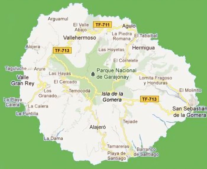 The large solidified magma massifs that shape the heart of the island have created a large depression more protected from the sun at its center, allowing the growth of a vast laurel forest, today grouped within the Garajonay National Park, La Gomera’s green lung, which has earned it the status of a World Biosphere Reserve. Its completely European appearance contrasts sharply with the rocky and tropical landscapes of the rest of the island. Thus, the climate varies greatly from one point to another on the island: in summer, you can quickly go from a dry and sunny valley at 35°C to a humid forest area at altitude at 18°C.

































 Roundabouts are particularly interesting because they feature emblems of Turkmen culture, like the dog, a carpet, the Ahal Teke horse, or Muslim symbols, even though the presence of Islamic artifacts is quite limited.



 Why this country?
After visiting Hungary, Slovenia, Romania, and Poland in recent years, I’ve fallen in love with Eastern European countries. I adore the Slavic soul, its Austro-Hungarian villages, the gentle landscapes, the Carpathian Mountains, and that slightly mysterious atmosphere.
Slovakia evokes a certain imagination with its deep forests, medieval castles, and cobbled villages.
After seeing photos of the High Tatras—especially Lake Štrbské Pleso and Spiš Castle—I thought, "Let’s do it! We’re going!"
So, will Slovakia live up to what I imagine?
We’ll find out together.
We decided to travel as a group of six (five adults and a six-year-old child), by car (we needed two).
Here’s the day-by-day itinerary for this family trip, which started with a 3-day stay in Vienna (see the dedicated travel journal):















 When it comes to the Caribbean island of Saint-Martin, it's customary to praise its coastline and dreamy beaches—and they certainly deserve it.
But in this story, I’d like to highlight other memories, aspects, and impressions for a slightly different change of scenery.
Enjoy the read—some text and, above all, lots of photos.
« Byenveni sou zile Sen Maten! » (Welcome to the island of Saint-Martin)






































 Come along, I'm taking you to this country where it's so nice to wander and slow down...










