Discussions similar to: Été 2025 destinations alternatives toute tranquillité
FR
Australia 2025: Discovering the 5th Continent
Hi everyone. Because that’s also what sparks the desire in every traveler (well, at least for me) to set foot on Australian soil: discovering a new continent.

Right now, I’ve got some time on my hands—those who follow me know that. A nasty muscle tear (which really doesn’t want to heal) is keeping me grounded for another week, so I’ve decided to open a new travel journal, recounting my recent trip from December 14, 2024, to January 12, 2025, in Australia.

The origins of this trip started last May in Crete, an island I chose for a 10-day break. It’s really lovely, by the way, but that’s not the point… It’s around this time every year that we decide on our next winter destination, and Argentina was at the top of the list—Sydney wasn’t even on the radar… I’d been looking at flights to Buenos Aires for a while, and the prices were shocking… But by the pool one lazy afternoon, scrolling on my iPhone, a promo from Geneva to Sydney caught my eye. The deal ticked two boxes on my traveler’s bucket list: a flight to Australia and a flight with Singapore Airlines, often ranked as the world’s best airline. A quick chat with the missus (well, of course!) and the decision was made: off to the land of kangaroos! Now, once you add luggage and Economy Plus, it still comes to 1600 € per person, but that’s a reasonable price. Either way, we already know what we’re in for—Australia is a budget commitment!


Thanks to 123rf for the image loan 😛
Open
So where are they and what are they doing?
This catchy and somewhat mysterious title comes from several questions I’ve been asking myself.

VF has been back open for a reasonable number of weeks and months now. The number of visitors overall matches past averages, but the number of members online in the last 24 hours seems relatively lower than what we used to see.

Yet, to my surprise, I’m seeing fewer travel journals, way fewer messages, and way fewer questions. I don’t see many new registered users online, and I notice a number of members who are logged in but either aren’t participating or have stopped participating.

Something’s not adding up for me because, in my opinion, VF is still appealing, and I don’t see which other sites could really compete.

Was there a real break between pre- and post-Covid? Does it just take more time for some people to discover the site or learn that it’s active again? Do people now prefer quick consumption on sites like FB or others I’m not familiar with? Where have the site’s old-timers gone, and what are they doing with their time now? What’s really going on here?
Open
Dans 10 ans, la Thaïlande, vous la voyez comment?
Ceux qui decouvrent la Thailande aujourd'hui en reviennent emerveilles..Ceux qui l'ont connus dans les annees 80 et 90 a l'epoque ou le portable et internet n'existaient pas ou presque, pourraient temoigner que c'etait quel que soit l'endroit ou on se trouvait un "vrai paradis"..Il est donc naturel que la nostalgie grandisse quand on voit dans quel sens et a quelle vitesse les choses evoluent.😕

Deja 2010🙁, et depuis les choses ont bien changes, que se soit dans les ghettos a touristes ou meme dans la Thailande profonde, celle que certains appellent a tord ou a raison la thailande authentique...

Mais dans 10 ou 20 ans, comment voyez vous la Thailande ??? comment sera t-elle ? ceux qui la decouvriront voudront-ils y retourner ?
Open
Planning a bike trip?
Who are you? Where are you from? Where are you going?

Like last year at this time, a post about bike travel ideas.

How many of us are preparing a trip planned for this year? Probably a lot.

What’s yours—the one you’ve been dying to do for so long, maybe too long? For us, it’s a modest PARIS-MARATHON by bike, followed by MARATHON-ATHENS on foot in June 2010. And you?

May the passion keep growing before, during, and after! Happy planning and safe travels to everyone.
Open
A Month in Laos and Cambodia
Hello everyone,

At the start of November, a bit of rest before winter will be perfect to kick off this travel journal. There aren’t many recent journals about this part of the world, so I’ll take the plunge—my way of celebrating the (unexpected) return of this forum, which has been such a big part of my life for over 15 years.

So, back to Asia at the end of 2023. After Myanmar in 2015 and Vietnam in 2018, we’ve chosen Laos this time. And when talking with friends (you know how it is—everyone asks, "So, where are you going this year?"), a couple of friends asked to join us ("You see, my wife dreams of a trip to Asia, and I dream of traveling like you, independently"). We’ve spent a week with them (and other friends) in Portugal, so we know they’re easygoing and flexible. They’ll only be with us after Christmas (due to lots of grandkids), so deal—we’re bringing them along! A new experience for us.

A new experience that’ll start with tweaking the itinerary. Originally, I planned to stay a month in Laos, but what could be more magical for my friend’s wife than discovering Asia by way of Angkor! Plus, our two daughters asked for some beach time at the end of the trip! So, it’ll be Laos and Cambodia—neither of which we’ve visited before, so no complaints there.

The route will be pretty classic, though a bit scattered to fit our dates and wishes. For us, we’ll arrive in Luang Prabang (LP) to take some time to acclimate, then a few days in the northern Laos mountains, Nong Khiaw and Muang Ngoi. Back to LP for a direct flight to Pakse. Yes, I know—so many amazing places we’ll miss along the way, but as you know, choosing means letting go... From Pakse, I’m leaving a few days open (no bookings), but I’m eyeing Champassak and the 4,000 Islands. That’s where Mariel and Naty (our friends!) will join us on December 30th. I’ve tentatively added the Bolaven Plateau loop to the plan (still no bookings). Their Laos adventure will be short—by January 3rd, we’ll cross the border into Cambodia, heading straight to Siem Reap for 5 days. Then, I’ll fulfill my promise with a magical detour to Koh Rong Sanloem via a night bus (a must-do in Asia!). On to Phnom Penh for 2 days—where our trip ends, while Mariel and Naty will stop in Bangkok for 3 days before flying home.

So, fasten your seatbelts, flight attendants at the doors, and sorry for the long intro—here we go on this Asian adventure!

Open
Some trips are born twice - Peru April - May 2025
Some trips are born twice.

Ours was supposed to happen in 2020. Everything was ready: the itinerary, the flight tickets, hotel reservations and Machu Picchu, the rental car, dreams of high altitudes and wide-open spaces. And then the world stopped.

Like so many other plans, our trip to Peru was put on hold. Disappointment was followed by a more concrete reality: paperwork, endless back-and-forth, and battles to recover some of the costs we’d already paid.

The years went by. Life moved on, with its shifting priorities and unexpected twists. Rescheduling this trip wasn’t possible until 2025.

The itinerary stayed mostly true to what we’d imagined five years earlier. One major difference, though—in 2020, we’d planned to rent a car and explore the roads completely independently. Most importantly, we hadn’t included the three-day Ausangate trek, due to lack of time.

For 2025, our plans evolved. 4x4 rental prices had skyrocketed, and when we looked at our schedule more closely, we realized quite a few days didn’t actually need a vehicle. So we made a different choice and opted for private drivers instead. A decision we never regretted. Always punctual, thoughtful, and available... they were so much more than just drivers.

All our reservations were made in January, except for the trek, which we booked in February.

Finding reliable drivers on our own was tough, so we asked Laurent from Tout Pérou to handle it for us. Going through Tout Pérou also gave us a discount on the train ride to Aguas Calientes, so Laurent booked those tickets too. He also bought our Machu Picchu entrance tickets at the same price we would’ve paid on the official website. When comparing domestic flight prices, we found it was cheaper to book from Peru, so Laurent took care of those as well.

This time, nothing was going to stop us. Peru was waiting. And we were ready. 🙂
Open
In the midst of Kenya's wildlife, October 2025
Hello everyone,

After sharing some safari photos from southern Tanzania, I’d like to show you those from our latest safari in Kenya in October 2025.

First, I’d like to thank Sylvie56, whose previous travel journals about this country inspired our trip choices. Thanks also for the info you sent us via PM. THANK YOU!

The following account is from a simple wildlife enthusiast. You won’t find anything here but images of landscapes, mammals, and birds. The stated purpose of this trip was purely and solely wildlife-focused. (It was in no way a discovery of the country or its people).

This stay/safari began (and ended) in Nairobi, with flights between France and Kenya operated by Qatar Airways departing from Nice.

Over two weeks, we first visited the reserves of Tsavo West and Tsavo East, then after a long road trip, the two reserves of Buffalo Springs and Samburu.

= Please wait until the end of the journal to ask any specific questions (or send them via PM) to keep the story flowing without interruptions or off-topic comments.

Thanks for your understanding.

...

Previous Kenya safari trip in 2017, here:

http://www.image-nature.com/forum/viewtopic.php?f=162&t=61119

...
Open
Masai Mara and Melting Pot Safari... So disappointed!
Hello everyone,

I imagine many of you have been captivated by the Masai Mara park and/or your safari experience with Tony Crocetta/Melting Pot Safari. Still, I’d like to share my perspective. First, I’m an avid traveler, especially in love with Africa, which my partner and I have explored a bit (Zambia, South Africa, Botswana, Kenya, Zimbabwe, Namibia...). That said, I want to express my deep disappointment with both the Masai Mara and Tony Crocetta’s camp, Melting Pot Safari, where we stayed last year.

First, about the park: it’s stunning, no doubt. But what a highly touristy place! I can’t find the words to describe the horror of being among 30 4x4 vehicles lined up in front of a lioness hunt, let alone encircling her right after her kill while her prey is still alive in her jaws... no respect for wildlife. The same goes for surrounding a young leopard playing with its small prey, a moment when I counted over 50 vehicles, most with their engines running... sickening. I turned away, both my gaze and my camera. What a disaster to see this natural wonder of Africa turned into a tourist hotspot.

Yes, I loved this place on Earth, but no, I won’t "promote" it anywhere or to anyone.

Next, I also wanted to share my dissatisfaction with Tony Crocetta’s famous camp, Melting Pot Safari: where to begin? We booked a private vehicle for four with two friends, and I have no complaints about the vehicle itself (though it obviously came at a cost). The windows and the vehicle weren’t very photo-friendly, but let’s move on. The trip between the sisters’ guesthouse (which was fine) and the camp went smoothly, except we arrived a bit too late. Result: "We’ll leave for the safari an hour later today because the driver has to respect his rest hours." Perfect—with park formalities, we only spent about an hour in the park that evening. The safari got off to a great start... During our 12-day stay, we saw some amazing things. Tony wasn’t at the camp—I don’t know what the atmosphere is like when he’s there, but it was rather cold during our trip. Sylvie, his wife, barely looked at us, never asking how our day, night, or game drive went (I think she spoke to us once during the stay, plus the day we arrived, of course). We felt invisible... (if I were mean, I’d say the money had already been deposited into Melting Pot’s bank account.) The evening meals, if I may say so, were a joke: not enough dessert (aside from fruit, but the few elaborate desserts—like 10 for 18 guests) for everyone, barely enough meat or sides. If you were unlucky like us and ended up with a group of 15 people who decided to skip the starter, you’d better hurry to get your main course, or there might not be any left—and no refills... We always ate our fill, but sometimes we had to serve ourselves in advance. Finally, I want to correct something about the quality of the meals: seriously, this buffet was really mediocre and far from the culinary standards I’d read about in my pre-trip research (see their Facebook page). Anyway, let’s move past the food—after all, the avocados were sublime, and we’re not there primarily to eat.

About the tent: the river views were beautiful, and the beds were very comfortable. No running water, individual showers outside the tent, and dry toilets—but it’s Africa, so we weren’t shocked. However, I’m disappointed that for this "modest" price, I wasn’t warned there’d be no soap (and no, I don’t travel with my own soap—and for the price, a little bar in the tent wouldn’t be a luxury). But let’s move on—the hippo views were fantastic. Oh, and to preserve the Masai Mara’s water (which makes sense) and for hygiene reasons, underwear isn’t washed by the camp staff—fair enough. But then what’s that little sign next to the bed? Oh right, for a hefty sum, underwear suddenly becomes "washable"...

Finally, my biggest gripe is about the essential part: the game drives. In France, they sell you a dream with a "photo safari" (what’s the difference, really? A room with a few more electrical outlets?). They promise guides especially suited for photography (not a given, sorry) and vehicles that can get close to animals and go off-road... but here’s the catch: the guides are bound by park laws and hounded by rangers looking to fine rule-breakers. Result: as soon as a white ranger vehicle is spotted, we have to abandon our spot for a wild chase through the grass. Fun once... The next day, we learned that another group’s guide got caught and had to pay $100 for breaking the rules—a sum he casually asked the travelers in his vehicle to cover... because of course, Melting Pot lures tourists with dreams, the poor rangers try to get close, all while breaking park laws... and they break those laws for Crocetta’s company, which, of course, won’t dip into its profits to pay the fines. Basically, it’s "keep the clients happy, but don’t get fined—or the fines are on you or you’ll have to ask the clients directly." Nice boss! Anyway, there were long discussions about this last year, especially among the guests in the fined vehicle. My partner and I found these practices unacceptable, and we were deeply disappointed by this attitude.

I know many people adore this park and/or this company—maybe you were luckier... or maybe you’re less demanding than we are when it comes to respecting rules, nature, and clients. But after traveling through much of southern Africa, I can tell you we personally came back frustrated from this experience and aren’t eager to return... You’ve been warned.
Open
Japan: First Discovery!
Here’s a little story about my first trip to Japan with my partner. We went for our first visit from October 29 to November 13, 2024.

I had planned this entire trip back in November 2020, but given the health situation at the time, I had to cancel...

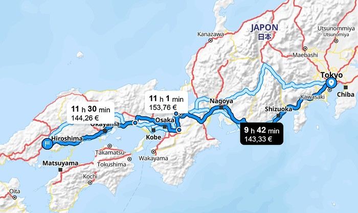
Here’s the classic route we took:

We booked everything ourselves and got a regional pass for the area from Kyoto to Hiroshima. The hotels were reserved 3 months in advance on Book... and Agod... (1030 € for 2 people for 13 nights = 80 €/night). For the flight, we chose a Qatar Airways flight with a layover to break up the long journey (950 € per person). We also got a pass on the same site (Japan-Experience) to take the train connecting Narita Airport to Shibuya Station (the N'EX Narita Express). Since the airport is 75 km from central Tokyo, we opted for this mode of transport, even though there are cheaper alternatives. After reading various posts on VoyageForum, I understood how important it was to have a Welcome Suica card to pay for public transport (subway, tram, bus, boat throughout the country), and we were able to buy one at Narita Airport. It turned out to be super useful! After a long but smooth journey, we found ourselves at Narita Airport in the evening. Even though we had a pass for the Narita Express, we had to go to a counter to make a reservation for the train (mandatory). Then, once we arrived at Shibuya Station, we took the subway for 2 stops and finally reached our hotel, exhausted (Hotel Asia Center of Japan – 270 € for 3 nights with breakfast included).
Open
Northern Chile, Andean impressions.
Alright, this year, we're heading back to South America!

The initial plan was to retrace the route we imagined in the summer of 2020: a trip to northern Argentina starting from Córdoba.

Unfortunately, the flight to Córdoba no longer exists, and airfares to Javier Milei’s country are both outrageously priced and involve multiple layovers.

So, I tweaked Google Flights every which way and finally found a flight within my budget—departing from Clermont-Ferrand!

Not to Argentina, though...

Our transatlantic flight will cross the snow-capped Andes, landing in Santiago, Chile, with a return from Lima!

In between, two domestic flights and a big road trip loop starting from the coastal city of Arica to explore the treasures of northern Chile.

Our mode of transport: a pseudo 4x4 that won’t take us through sand dunes or devilish tracks but will let us tackle the entire secondary network, including unpaved main roads, while still being insured.

Is the suitcase packed with all-season clothes?

Are the driver’s license and passport ready?

Bank cards and a few euros too?

Off we go for just over 3 weeks of southern wanderings!


--/--

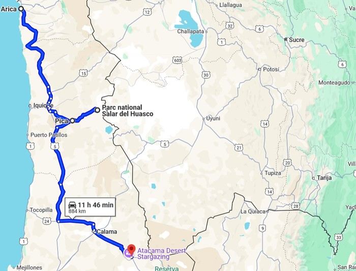
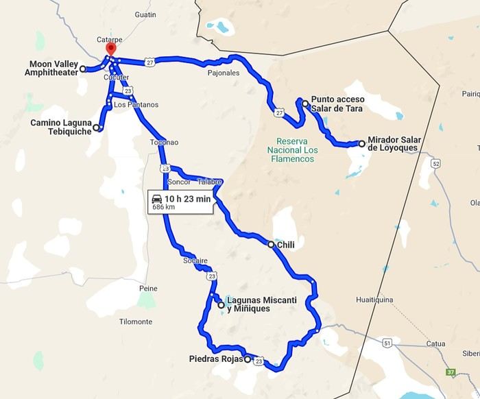
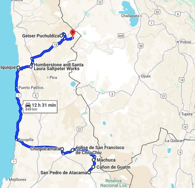
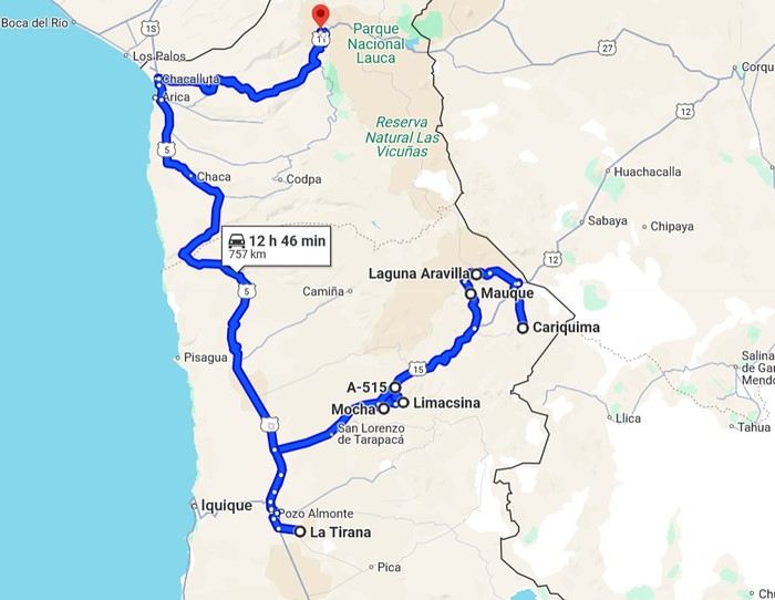
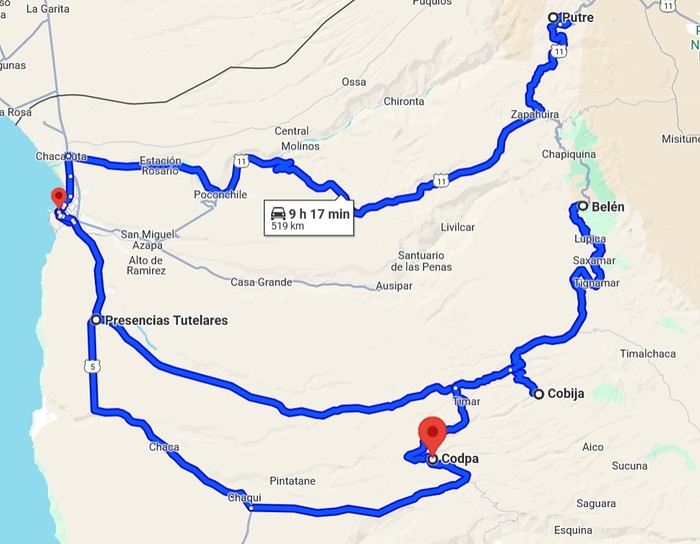
To keep all my esteemed readers on track, here are a few maps outlining the Arica-Arica loop!

1- From Arica to San Pedro de Atacama via Pica and the Salar de Huasco

2- Around San Pedro


3- From San Pedro to Cariquima


4- From Cariquima to Putre


5 - From Putre to Arica


Gas stations in this part of Chile are located in Arica, Iquique, Pozo Almonte, Pica, Calama, and San Pedro de Atacama.
Open
Impression négative de l'Inde
Bonjour a tous,

J ai passe un mois en inde, avec mon petit ami, en janvier dernier.

Avant de partir, j ai largement utilise ce forum afin de preparer un itineraire qui nous a paru bien adapte. Nous voulions voir un maximum de choses. Nous avons donc fait Bombay, vol pour Jaipur, Pushkar, Udaipur, Bundi, Agra, Varanasi, vol pour Delhi, vol pour Bengalore, Ooty, Ernakulam et enfin un trajet sur les backwaters vers Allepey.

L arrivee a Bombay a bien sur ete depaysante, saisissante, mais supportable. Le reste des villes du Nord nous a paru insupportable, dans chaque ville nous etions presses de partir pour voir si c etait moins pire ailleurs. Le Sud nous a paru moins penible. Ce qui nous paraissait si difficile a vivre c est simplement les gens, le regard, les arnaques, on en venait a parler d harcelement quotidien!

Je reviens aujourd hui sur ce forum pour voir si d autres personnes ont ressenti la meme chose, apparement non. Mais je trouve ca vraiment surprenant, en Inde nous avons rencontre plus de touristes qui ne supportaient pas le pays plutot que ceux qui l appreciaient.

Je ne pense pas que j en viendrais a deconseiller de visiter ce pays, puisque chacun a son idee, mais je pense que les gens qui visitent ce forum doivent savoir que l Inde n est vraiment pas un pays facile et "enjoyable" (si quelqu un a un mot en francais pour ca, je prend).

Merci pour vos reactions.
Open
2 weeks in the Cyclades
Hi everyone!

Blue skies (lots of them), whitewashed villages with steep alleyways, hundreds of churches, and... thousands of stairs? Welcome to the Cyclades! 🙂

We’d been dreaming about this for a while, but in July-August—with the crowds—no way! Now that I can travel outside school holidays, the Cyclades are back on the agenda. And so begins a loooong period of planning and second-guessing, with countless itinerary changes: the Cyclades, yes, but which ones? I was fixated on Folegandros (we won’t be going after all) and really wanted to visit Delos. So, for this first trip, it’ll be: Mykonos (and Delos)-Naxos-Amorgos-Santorini.

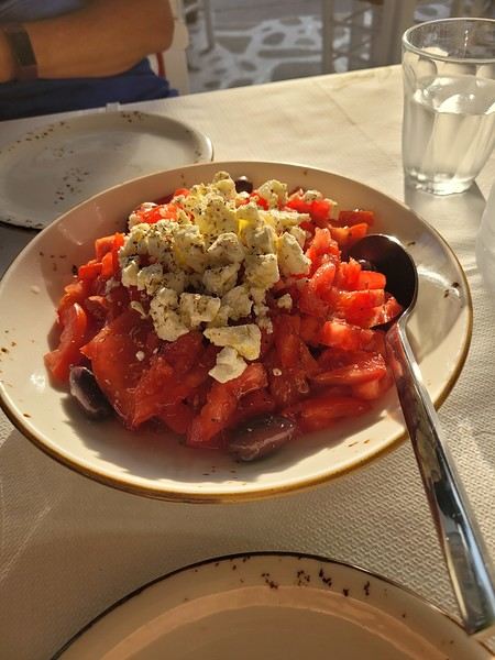
Saturday 24/05: Departure from Orly on a Transavia flight, arriving in Mykonos in the late afternoon. We found a hotel that offers free transfers (pretty rare and not insignificant—it’s 25 € each way for just a few kilometers 😠) and at a reasonable price (83 € per night for B&B). Time for dinner already: Greek salad and souvlaki (we’re in Greece, right?)

(Okay, this is actually a dakos with Naxos cheese, but I don’t have a photo of a Greek salad 😏).
Open
Thailand, Cambodia, or Vietnam?
I really loved Thailand, but it was too touristy for my taste. So I'm hesitating about going back and wondering if Cambodia or Vietnam would be less crowded with tourists...
Open
Currency exchange while traveling: why do some still carry wads of cash?
Hi everyone,

In this age of zero-commission cards and fee-free accounts, I’m curious why some travelers still prefer to set off with a wallet stuffed with bills and exchange money on the spot.

I get it for those whose income comes from undeclared activities, but what about everyone else?

Between the risk of theft, scams at exchange counters, and fees that often end up being higher, I’m really puzzled.

The last time I traveled with a wad of cash was because I had to pay for accommodation in cash only, the local currency was the dollar (easy to exchange at a very low cost), and I was still paying some fees.

I’m still wondering about my next trip to Argentina because the situation there is very specific, but otherwise?

Is it an allergy to modern payment methods?

A budget so tight that an extra 20 € (the fees some local banks charge for withdrawals) on a 2000 € budget would be impossible to manage?

Thanks for shedding some light on this!
Open
Qui va dans l'ouest des États-Unis et quels circuits fin mai-juin 2011?
Hello,

Sur le modèle du "famous" post du Tigre (pour le mois de juin 2009 ou septembre 2011, ou encore ma 1ère copie en mai 2009), je vous propose de poster ici vos dates dans l'Ouest des USA et un petit resumé de votre trip avec les étapes importantes pour des dates entre fin Mai et Juin 2011.

Ce topic est là pour discuter entre voyageurs partant en mai/juin 2011 pour l'Ouest (présentation du circuit, étapes...) et "éventuellement" s'y croiser en cas d'étapes communes, mais pas pour chercher un Compagnon de Voyage 😛

@+ Vnoa
Open
Déçu par la Thaïlande
Bonjour je suis en Thaïlande depuis une semaine et je vais de déception en déception. Peut-être n'ai je pas eu de chance. Mais je trouve ce pays bouffé par le tourisme, il faut réservé les transports une semaine a l'avance, actuellement je suis bloqué a Ayuthya ( pas super beau, les monuments sont au milieu de la ville) pas moyen de sortir d la ville car il n'y a plus de bus. Je dois aller a Chang Mai, mais j'ai peur d'être déçu. Est-il possible de trouvé des endroits préservés dans ce pays? Des amis ont fait des kilomètres depuis la France pour me rejoindre en Thaïlande, ils sont super déçus. J'ai pourtant l'habitude de voyager, je voyage depuis 5 mois en Asie, et ai parcourt le monde, c'est le seul pays qui me déçois comme ça
Open
MSC Fantasia, départ le 20 juillet 2014 de Venise
Bonjour tout le monde !

Nous partons pour notre 1ère croisière MSC cet été. Nous avons déjà fait une transatlantique Costa, pour notre voyage de noce, il y a 2 ans et avons attrapé le virus ! 😛

Cette fois nous partons avec nos 2 filles de 6 et 12 ans et sommes preneurs de tous les conseils que vous pourrez nous donner sur cette destination (Italie, Grèce, croatie), mais aussi sur l'organisation MSC en comparaison de Costa.

N'hésitez pas à échanger avec nous aussi sur ce post si vous partez pour la même croisières, ça nous donnera l'occasion de faire connaissance avant le départ et d'échanger nos bons plans, avant un apéro bien mérité sur le bateau !! 😏

@ vous lire donc !

Isa&Nico
Open
Namibia Travel Journal: May 2025 - Trip Review
NAMIBIA TRIP 2025: April 24 to May 20: Feel free to comment or ask us any questions about this amazing journey.

>> Find all our photos and videos for each day on our website here: www.montagne-aventure.net

**DAY 1: Thursday, April 24, 2025: Outbound Flights from Lyon to Windhoek via Munich - Visit to Munich:**



Off we go on a new adventure. The alarm rings at 6:30 AM, the travel bags are packed, and we head to Lyon Airport. We booked our flight tickets with Lufthansa. The first leg to Munich, Germany, is operated by AirBaltic. Departure at 1:05 PM for a 1-hour and 20-minute flight. We arrive at 2:30 PM.

**We now have a 7-hour layover, so we take the opportunity to get some fresh air and explore Munich.** We quickly exit Terminal 2 of the airport and head towards the subway. We buy a group day ticket "Airport-city Day Zone M-5," valid for 2 to 5 people at a price of 30.50 € (instead of 16.30 € per person). We take the S8 line to **Marienplatz** in 35 minutes. **This is the heart of the city.** The weather is overcast, quite cool, but dry. Perfect for a little city trip between two flights while leaving our large luggage in transit at the airport. **Munich is the third-largest German city after Berlin and Hamburg, in the Bavaria region.** **The center has a lot of charm and brings together several religious buildings, easy to explore on foot.** We are impressed by the number of people enjoying these 100% pedestrian streets, which are very pleasant. After Marienplatz, the most famous square with the town hall, we head to the Cathedral of Our Lady, a Gothic church, then continue to **Karlsplatz** and move on to **the food market offering a wide selection of high-end food products in an atmosphere where a certain art of living prevails.** We also visit St. Peter's Church before grabbing a bite to eat. Two good hours were enough for this 10 km city walk. It's time to take the subway back: by 6:30 PM, we are back at the airport. Now, it's time for a bit of waiting and rest. Our second flight is scheduled for 9:35 PM for a 9-hour and 30-minute journey to our final destination in Namibia: **Windhoek.**

> Round-trip flight tickets with Lufthansa from Lyon: 2029 €, or 1,014.50 € per person.

> Lyon Airport parking: 120 €

> Today's expenses: 7 € for 2 pizzas in France / 14 € for the restaurant in Munich / 30.50 € for the daily subway ticket in Munich.

**DAY 2: Friday, April 25, 2024: Arrival in Windhoek, Visit to the Namibian Capital:**

After a 9-hour and 30-minute overnight flight with Discover Airlines, we finally land on Namibian soil just before 7:30 AM. The day is breaking, and the colors are already stunning. We are eager despite the usual fatigue from the flight. The airline was punctual, with friendly staff and good meals, though a bit light. We are the first flight of the day to land, with no more than 15 flights per day here, from 7 AM to 8 PM. We disembark on the tarmac at this airport located in the middle of nowhere, **I finally set foot on African soil for the first time.** We exit among the first from the aircraft to go through the long formalities at the front of the line, as the wait can quickly become endless. Allow at least 5 minutes per person for e-visas. We still wait 45 minutes despite only about twenty people ahead of us. Phew, it's done. We collect our luggage and then withdraw money from an ATM. We make 4 withdrawals of the maximum amount, 2000 NAD $ per withdrawal, for a total of 380 €, or 95.33 € per withdrawal.

Our driver arrives at the same time, perfect timing, we were quick.

We leave the airport at 8:45 AM. By 9:30 AM, we arrive at the **Gracious Whisp vehicle rental agency**, located at the entrance of Windhoek, small and human-sized with a fleet of recent vehicles. More formalities, then a short wait as our vehicle is not yet ready. Time to decompress, catch our breath, and enjoy the very pleasant morning temperature. Not a cloud in sight. Next, a briefing on the vehicle, always with a bit of apprehension due to our approximate English. Allow 45 minutes of explanations, including setting up the roof tent, camping equipment, technical information in case of a flat tire, driving tips in Namibia, and a tour of the 4x4. We have all the necessary equipment for camping: mattresses, sleeping bags, pillows, table, chairs, gas stove, BBQ grill... as well as 2 spare tires, a compressor, a dual tank, and accessories for removing wheels. Off we go, it's time to muster our courage and get behind the wheel. **Heading to SuperSpar Maerua**, fortunately located less than 10 minutes away. We park with the help of a parking attendant; it's very crowded, the space is narrow, but everything goes well despite the cursed right-hand drive. Today's new mission: stock up on groceries. The store is well-stocked with local and imported products, catering to all tastes. We spend 114 € on groceries, from pasta to meat, BBQ lighters to dishwashing products. Two people load our groceries into two carts and transfer them to our vehicle; we feel compelled to leave a tip, 50 NAD $, as we don't have change yet. Now, we head to the hotel, 15 minutes away. Traffic is difficult at a complicated intersection; this will likely be the only traffic jam in Namibia. **We arrive at Kate's Nest Guesthouse & Backpackers around 1:15 PM, quite tired.** We take some well-deserved rest at this recent establishment, quite calm with secure private parking. After a short nap, we enjoy the quiet by the hotel pool. Night falls between 6:30 PM and 7 PM. We eat quietly in our room tonight before starting this long 4x4 road trip in camping mode in the heart of Namibia.

> Today's grocery expenses: 114 € at Super Spar Marua (2395.21 NAD $).

> Round-trip flight tickets with Lufthansa from Lyon: 2029 €, or 1,014.50 € per person.

> Vehicle rental: 4x4 Toyota with roof tent for 24 days: Gracious Whisp Car Rentals: 2,638 € (N$50,640) or **1,319 €** per person - (https://gwcarrentals.com/)

> Distance driven today: 15 km.

> Accommodation: Kate's Nest Guesthouse & Backpackers - 4 Aristotles Street Academia, 9000 Windhoek - 36 € for two for one night.

> Windhoek International Airport website: (https://www.airports.com.na/)

**DAY 3: Saturday, April 26, 2025: Windhoek to Hardap: Mariental Region - Kalahari Desert:**

After a good, restful night, we wake up leisurely around 7 AM. We enjoy the comfort provided by this first and last hotel before 24 nights under the tent.

**We leave Kate's Nest Guesthouse at 8:30 AM to tackle the Namibian roads.** We quickly leave the capital; in just 30 minutes, we find ourselves almost alone in the world. The landscape is dotted with small domes. We leave the **paved B1** quickly to turn left onto the **C15**. **From there, we won't see more than 10 vehicles all day.** After passing through the few houses of **Lekkerwaterpoort**, we tackle our first gravel road. These road sections are limited to 100 km/h, but even at 70 km/h, I find it already challenging. However, I quickly get used to it and gradually pick up speed to reach my cruising speed of around 80 to 90 km/h. **We are on immense straight lines crossing wild expanses as far as the eye can see.** **We come across two baboons, a few ostriches, and numerous cattle and sheep farms.** We pass through the charming village of **Uhlenhorst** with its typical houses and children with broad smiles waving at us. Life here is already very different from Windhoek. **The thermometer rises quickly from 16°C at 8:30 AM to over 28°C in the early afternoon.**

**We arrive at the Hardap Dam reserve at 2 PM.** We stop at the toll booth at the park entrance to pay the entrance fee: 250 NAD $ for 2 people and 1 vehicle. We continue to the dam and then the camp entrance, located a bit further. We had booked in advance, but this place remains little frequented by foreigners.

We take advantage of the hottest hours to rest by the large pool overlooking the immense lake, a very enjoyable moment. Would this be a bit of a vacation?

Around 4:30 PM, we head to the campsite. We overlook this vast water reserve. We arrive first; we will be only 3 vehicles spending the night here. It's time to get to work and set up our equipment for the first time. It takes us a good 20 minutes to set everything up, with a slight apprehension about unfolding the tent. Once this task is done, which we will have to repeat for almost a month, we will become much more efficient over time. Time for rest and contemplation in total silence. The sun gradually sets, and the heat quickly becomes bearable again. Bliss! **This dam is located 20 km northwest of Mariental in an area dotted with conical hills topped with dolerite buttons (Hardap means "hillock" in Nama). It captures the Fish River, which flows south, creating a large lake in the middle of an arid environment. The contrast is striking.** We enjoy our first sunset facing this 360° otherworldly landscape.

Around 7 PM, we start our first BBQ, or "braai" as it's called here. The temperature is perfect. The sun sets, giving way to a star-filled sky of incredible beauty thanks to the absence of any light pollution. The Milky Way will lull us throughout the evening. After some good sausages and potatoes on the BBQ, we head to our roof tent around 9:30 PM with a complete change of scenery in just 24 hours. France already seems so far away...

This campsite has shared showers and toilets, quite clean and functional, as well as a central area with several BBQs and tables. The sites are arranged in a semicircle, each with an electrical outlet. The sites are close to each other but spacious, some slightly shaded. We are only three vehicles tonight, so it's perfectly comfortable and quiet. Not to mention the large pool near the restaurant. Our trip is off to a great start.

> Today's road itinerary: Windhoek > Head south on the B1 to Rehoboth > Turn left onto the C25 then C15 to Stampriet > C20 to Hardap > Full north on the B1 > Then turn left onto the M93 - 5 hours of driving.

> Distance driven today: 354 km.

> Accommodation: Hardap Recreation Resort - 23.3 € for two - Large pool - GR6W+3M2, Hardap Game Reserve, Mariental, Namibia - (http://www.nwr.com.na/resorts/hardap-resort/)

**DAY 4: Sunday, April 27, 2025: Hardap - Brukkaros Volcano - Keetmanshoop - Quivertree Forest Rest Camp**

Our first night under the tent was very pleasant; the little wind quickly calmed down, giving way to absolute silence. The mattress is decent, more comfortable than some nights in Nepal. The length and width give us enough space for maximum comfort, despite my height (1.91 m). We wake up a little before 7 AM as the sun rises, and the lights dazzle us from the start of the day. We pack up the equipment in 30 minutes, quite easily. Then we enjoy the sun, which warms up quickly while we keep our light fleece on.

At 8:30 AM, **we hit the road again, heading south** to our first stop in **Mariental**. We want to do some shopping at SuperSpar, but once we arrive in the parking lot, a young local is fighting with the supermarket security guards and then threatens to throw stones. We don't want to take any risks right at the start, so despite the baton blows he receives, he doesn't stop. We leave empty-handed but fill up with fuel at the Shell station 1 km further. The price per liter is 21.33 NAD $, we fill our 107-liter tank for 107 €. In Namibia, you get served, and they bring the card machine to the window to pay. It's then customary to leave a tip.

We then take the B1 heading due south on a recently renovated road. Around 11:30 AM, we leave it on our right to take **a wild gravel road, the M98**. Just before **Berseba**, we turn right onto a small track, the **D3904 towards Brukkaros Crater up to a camp at 1588 m altitude**. The track then becomes too bumpy. We stop on the counter-slopes where **a wide panorama unfolds over these immense plains as far as the eye can see**. It's 12:15 PM, time for us to eat a rice and tuna salad facing this landscape.

**We are alone in the world until a vehicle arrives and parks next to us.** A bit of apprehension, 4 men head towards us. It turns out to be 4 shepherds looking for a lost foal. The conversation is pleasant, lost in the middle of nowhere. We find ourselves alone again in this absolute silence. **The heat becomes stifling with a good 30°C**. We get back on the road around 1 PM. Back on the B1, **we continue due south to Keetmanshoop**, which we reach around 3 PM. We stop there to do some shopping for 262 NAD $ (12 eggs, a can of tuna, a can of corn, bread, a soda, and a 5-liter water container), or 12.48 €. Two quite insistent children ask us for money or candy at the store exit, yet we give them a small tip, but they continue to cling to the car. Locals parked next to us tell them to leave us alone. Anyway, we finish the trip to **Quivertree Forest**, 15 km away. We will spend the night in this **pleasant farm run by a German**. Upon arrival, as the day before, and as I suppose in the future, we dive straight into the cool pool to relax after all these kilometers. A bliss. Then we take our 4x4 and choose a spot near these famous trees. After the 33°C this afternoon, once 4 PM passed, the temperature drops again and becomes very pleasant. **We are in the middle of the Kokerboom, one of the most interesting and characteristic plants of hot and arid regions. It's not really a tree but a variant of the aloe plant whose botanical name is Aloe Dichotoma. This Kokerboom has a smooth and thick trunk reaching up to 1 m in thickness and 9 m in height. They bloom for the first time at the age of 20 to 30 years.** The flowers are yellow and reach about thirty centimeters during the season between June and July. **They grow mainly in an environment with a high concentration of black rocks absorbing a large amount of heat (38°C). The rocks also serve to anchor the tree with its tentacle-like roots. It also resists frost. Each is between 200 and 300 years old.**

Around 5 PM, we walk to the farm reception to watch the feeding of **two cheetahs**. Magnificent carnivores taking their time to savor their piece of meat. **Then we return near our campsite to enjoy the sunset among these trees. The colors are sublime, as every evening apparently. A magnificent spectacle with colors evolving from yellow to orange then to pink, before giving way once again to a sky filled with thousands of stars.** Our campsite at Quiver Tree Forest Camp is very comfortable; we have a water supply, a stone table, a small lamp, an electrical outlet, a small tree for shade, and a BBQ that we won't use tonight; we'll cook on gas. The sites are far apart, with some shared facilities scattered around, a very beautiful setting. No reservation possible, no need, just show up directly. **The campsite accommodation for 2 people costs 28 €, including the reserve entrance fee of 5 €**. We finish this second bivouac evening around 9:30 PM, time for some reading and sleep in peaceful silence without wind.

> Today's road itinerary: Mariental > B1 heading south to Brukkaros > At Tses turn right towards Berseba via the M98 > Turn right onto the D3904 > 8 km > Brukkaros Volcano (stop at the lower camp as the track is difficult for 1 hour) > Keetmanshoop > Turn left onto the M29 > Quivertree Forest - 4 hours of driving.

> Distance driven today: 371 km.

> Distance walked today: 6 km.

> Today's expenses: Groceries for 12.48 € (262 NAD $) / Fuel for 107 € (1 liter of diesel for 21.33 NAD $).

> Accommodation: Quivertree Forest Rest Camp, P.O. Box 262, Keetmanshoop, Namibia - BBQ, hot showers, toilets, and electricity - No reservation - Pool - 18 €/Person (N$ 340.00 with park entrance) - (http://www.quivertreeforest.com/)

**DAY 5: Monday, April 28, 2025: Quivertree Forest Rest Camp - Giant's Playground - Keetmanshoop - Fish River Canyon - Canyon Roadhouse:**

After an excellent start to the night, we are woken up by the wind shortly before 6 AM, but the sunrise is not far off. We get up at 6:30 AM to enjoy it. The atmosphere is a bit cooler this morning, but the reward is already here.

The adventure continues. At 7:45 AM, we head towards **Giant's Playground**, 4 km away. We take a 3-kilometer walk through this expanse of blocks and igneous rocks.

We continue south at 8:45 AM, passing through Keetmanshoop again where we do some shopping for 25 €, a big stock-up for a good part of the trip: meats, canned goods, pasta, fruits... At 9:30 AM, we take the B4 to Fish River Canyon.

At 11:30 AM, we arrive at the entrance to the NWR park (350 NAD $ entrance for 2 people and 1 vehicle). The track becomes bumpy immediately upon entering the park. After about ten kilometers, we come upon this landscape carved by nature. In the end, it's well worth the detour. We were at the Grand Canyon in the USA exactly (https://www.montagne-aventure.net/2024/04/29/j21-3-juin-2024-grand-canyon-et-lac-powell/) and can thus confirm that this Fish River Canyon is comparable. We make several stops along the southern flank. **Here, nothing is developed; nature is almost in the wild state.** **With 160 km in length, up to 27 km in width, and a depth of 150 m, it is indeed the second-largest canyon in the world.** The history of the canyon is apparent in its different earth layers and stratification: the antiquity of the place is tangible, and the absence of vegetation is surprising. **It consists of two nested canyons, formed at distinct periods. The first distinct layer of schist, sandstone, and eruptive material surrounding the canyon was formed a few two billion years ago, then transformed due to heat and pressure into more solid rock such as gneiss. The inner canyon, carved more recently by the Fish River, has a depth of 270 m.**

We have a picnic once again alone in the world facing this grand panorama at the **Sulphur Spring View Point**. This is where the hiking trail begins, plunging into this narrow canyon, but it is forbidden to venture there alone without a guide. It's 30°C, but a slight wind makes the atmosphere bearable. At 1 PM, we retrace our steps and continue to the **Main View Point** then to the **Hikers View Point**.

In the south of Namibia, the Fish River Canyon, 160 km long, is a true geological wonder: a canyon nested within another canyon, one of the largest in the world. The first sedimentary layers formed two billion years ago; 500 million years ago, a period of tectonic activity caused these layers to crack and tilt, opening a vast canyon in the Earth's crust. The second canyon, with a depth of 270 m, was carved over time by the passage of the Fish River in this new valley.

At 3 PM, we arrive at our very charming camp for the evening, the **Canyon Road House**. We fill up with fuel right away because tomorrow we have a long day of isolated driving: 55 liters for 1240 NAD $. Then we settle into the campsite we had previously reserved in France. We are assigned site 2, very well set up under a tree with its BBQ and stone table just steps from the pool. We quickly set up the tent and jump straight into the pool for the relaxation moment of the day. As usual, the water is quite cool, but it's a real pleasure. Then we stroll around this Canyon Road House, which recreates the atmosphere of the roadside inns of the 1950s with old car wrecks and vintage gas pumps in a bygone era. **Around 5:45 PM, we start a short walk leading us to the top of a hill overlooking the wide plateau where we are to watch the sunset.**

And finally, to end this beautiful day, it's time for the braai, with grilled sausages and white beans on the evening menu.

> Park entrance: 150 DN/person + 50 DN/vehicle (18 € for two). It is possible to enter at two access points: Hobas in the north and Ai-Ais in the south.

> Today's road itinerary: M29 > Keetmanshoop > B1 > B4 > C12 (track) > After Holoog turn right onto the D601 (C37 track) > Accommodation on our right (stop just to check in before 6 PM) > Continue 30 km (30 minutes of track) to the viewpoints after Hobas where you must pay the entrance fee. Sunset View Point to the left > Return before sunset as the park closes (best lights at sunrise). 3 hours.

> Distance driven today: 228 km.

> Distance walked today: 10 km.

> Today's expenses: 25 € for groceries / 17 € for the Fish River Canyon park entrance / 58 € for fuel.

> Accommodation: Canyon Roadhouse, Gondwana Collection Namibia – 34.4 € for two - Pool - Near Hobas - (http://www.gondwana-collection.com/fr/accommodation/canyon-road-campsite)

**DAY 6: Tuesday, April 29, 2025: Canyon Roadhouse - Orange River - South African Border - Vista Trail - Gondwana Sperrgebiet Park - Aus:**

The night was excellent in this very comfortable campsite. **We wake up to the sound of birds** before the alarm at 6:45 AM. Our little morning routine starts as the sun rises. **A big day of driving awaits us to the South African border. This will be the southernmost point of our journey.** We hit the road at 8 AM via the C37, pass through **Hobas**, then turn onto the D207 to **Aussenkehr.** **We cross a mountainous barrier with some high peaks and perfect cones. The rock varies from orange to pink to black.**

We then cross a lunar desert as far as the eye can see on a giant dome; the track winds through nowhere without meeting anyone for hours. The landscapes are surprising. **We spot several ostriches and a gemsbok.** In the middle of this endless expanse, we come to an improbable intersection and continue right onto the D278.

In the middle of these arid lands, we come across a green zone: a vast vineyard. At 10:30 AM, **we come across a "Road closed" sign, fortunately, a local resident waves us to continue; a bit stressed, we proceed.** We start to follow the beautiful Orange River. On the other side of the bank, just a few meters away, South Africa is there. It is the second-longest river in Southern Africa, after the Zambezi. It flows over 2,000 km to the Atlantic. After passing through narrow gorges, we regain altitude before starting the descent, gently heading back north.

**We now cross and follow the Fish River, which joins the Orange River further south** **along this gorge dating back millennia.** At exactly noon, we take a lunch break by the Fish River, still without meeting a soul in this landscape between greenery and aridity. The temperature here is cooler with a pleasant 23°C on the banks, the perfect spot. **We continue on the track to Rosh Pinah**, where we find a paved road again. **The section along the Orange River and the Fish River was officially closed, but we were able to pass without any issues, avoiding a detour of at least 3 hours.** Phew. We now drive at high speed (limited to 120 km/h) through these vast spaces. We come across many ostriches after the **dozens of monkeys along the Fish River**. Around 3 PM, 3 km after the very small town of **Aus**, we reach **our campsite for the evening at Klein Aus Vista**. A new **small peaceful haven very well set up**. As usual, after checking in at reception, we jump straight into the beautiful pool to get our well-deserved dose of coolness, another good thermal shock that our bodies appreciate. Once this moment of relaxation is over, we take our 4x4 to reach the campsite located a bit higher, set apart at the foot of a hill that overlooks us.

After setting up, **around 5 PM, we head to the Vista Trail to climb to the top of a mountain overlooking the vast plain that surrounds us at 360°**. It takes about 30 minutes to climb. The place is just magical, **the perfect viewpoint to admire the sunset**. **We fully savor the moment. We also spot one of the few wild horses in the world capable of living in the desert.** Their numbers have decreased in recent years due to predation and drought (around 100 to 150). At 7 PM, we return to the camp, time for the braai and preparing the meal in this peaceful little camp.

In the south of Namibia, the Fish River Canyon, 160 km long, is a true geological wonder: a canyon nested within another canyon, one of the largest in the world. The first sedimentary layers formed two billion years ago; 500 million years ago, a period of tectonic activity caused these layers to crack and tilt, opening a vast canyon in the Earth's crust. The second canyon, with a depth of 270 m, was carved over time by the passage of the Fish River in this new valley.

> Today's road itinerary: 5 hours of driving: D324 heading south (track) > turn right onto the C10 (track) > D316 heading south > turn right onto the C13 > In Aus turn left onto the B4 > Campsite via a track on the left.

> Fuel station: Solitaire or Aus.

> Distance driven today: 398 km.

> Distance walked today: 7 km.

> Accommodation: Klein-Aus Vista Desert Horse Campsite - Farm Klein-Aus No 8 on the B4 main road to Luederitz Aus 9000, Aus, Namibia - (http://www.klein-aus-vista.com/accommodation/desert-horse-campsite/) 17908 420 DN - Water + Shared shower (hot water). No electricity.

**DAY 7: Wednesday, April 30, 2025: Aus - Kolmanskop - Diaz Point - Luderitz - Kanaan Desert:**

We wake up around 6:45 AM, with partly cloudy weather for once; we feel the ocean's influence gradually. But the sun isn't far off. At 7 AM, we leave the campsite heading west towards Luderitz via the B4. **First stop of the day: Kolmanskop, the ghost town we reach at 8:30 AM**, entry costs 180 NAD $ per person. We discover this **timeless place** in 1.5 hours, moving from building to building amidst violent sand-laden gusts of wind. There's a lot of charm in these different living spaces. **The sand quickly reclaimed the place after this mining town was abandoned.** This was once the headquarters of Consolidated Diamond Mines. It's hard to believe that this former town, where the diamond industry once flourished, had a hospital, a bowling alley, and a theater. The decline in diamond sales after World War II and the discovery of richer deposits put an end to this golden age. By 1956, the town was already completely deserted, and the sand had reclaimed its rights. **These dilapidated buildings swallowed by shifting dunes have something surreal about them.**

At 10:15 AM, we hit the road again **heading to Luderitz, 22 km away**, and first to **Diaz Point** **facing the Atlantic Ocean**. It's a wind-swept peninsula with its characteristic red and white lighthouse. There's a campsite and a coffee shop on site, but the place doesn't inspire rest without shade or shelter from the wind. We return to the city via the D701 track that runs along the ocean, be careful at low tide. We come across **a few fishermen and a fox as well as flamingos.**

We walk through the few streets of the city, much smaller than I imagined, then climb to the **famous little Lutheran church that overlooks the city, the Felsenkirchr.** **The wind blows very strongly here, and the sand is omnipresent, surrounded by the Namib Desert and the southern Atlantic coast.** **A German colonial relic barely touched by the 21st century, Luderitz seems frozen in the past, giving it both a gloomy and a certain charm. In short, it's certainly one of the most incongruous places in Africa.**

At 1:15 PM, just before leaving Luderitz, we do some shopping for 20.50 € and fill up with fuel: 61.50 €, 1290 NAD $ for 61 liters (21.18 $ per liter).

**We return via the B4 to Aus** (paved), **then via rougher tracks**, the C13 then the D707, magnificent as it runs along a mountain range with multiple colors on our right and an endless flat desert on the other side.

To access our campsite for the evening, we must take a **narrow private track for 7 km** on our right to emerge, in this total vastness, at the **isolated Kanaan Desert Retreat on a small hill**. I don't have time today to jump into the pool near the reception; we arrive at 5 PM at 8 small, isolated, and unique sites with a small kitchen, a shower, and a private toilet under a small tarp shelter. **A crazy charm with a unique view...** **This will be my favorite accommodation of this trip. The photos speak for themselves.** We jump into the outdoor shower while savoring the landscape, then prepare our evening braai while enjoying the colors fading, facing this plateau with bushes turning a vivid orange. **A moment that will remain etched for life.** **Savanna atmosphere under a thin emerging moon. Every minute offers different colors. Facing our meal, we have a natural giant screen.**

We end this day contemplating the stars and admire this thin orange moon setting on the horizon (8:42 PM).

**Ghost town just before Luderitz: Kolmanskop** (open from 8 AM to 3 PM - N$ 180 p.p – 9 €). Once, Kolmanskoppe was organized around diamond mining. After finding new, more prolific spots, the town was abandoned and is now a ghost town. The sand and dunes have reclaimed their rights and buried everything humans had built. Houses, train station, bakery, everything has been covered by sand, which passes through the windows, even though they are 1 meter high.

> Today's road itinerary: 5h30: B4 to Luderitz (paved) > Round trip > Kolmanskop on the left > Return via the previous campsite > Then C13 (track) > Turn left D707 (track) > Then track to the right to the campsite.

> Distance driven today: 438 km.

> Distance walked today: 8 km.

> Today's expenses: Groceries at the Spar in Luderitz for 20.50 € / Fuel fill-up in Luderitz for 61.50 €.

> Official Kolmanskop website: (https://kolmanskuppe.com) (open from 8 AM to 1 PM - N$ 180 p.p – 9 €).

> Accommodation: Night at the south of the Namibrand Nature Reserve: Kanaan Desert Retreat – 26.5 € for two - (http://www.kanaannamibia.com/) - Farm 104 Karas 9000 - Sanitary facilities + BBQ + Water + Pool - No electricity - My favorite accommodation of this trip.

**DAY 8: Thursday, May 1, 2025: Kanaan Desert Retreat - Namib Desert - Crossing the Namibrand Nature Reserve – Sesriem Canyon - Elim Dune - Little Sossus Lodge**

After a cooler night than the previous ones with about 10°C, we wake up around 7 AM. We admire, as usual, the sunrise between the desert and the mountains. **The spot from last night was truly perfect, isolated from the world, in total serenity, with a wake-up call to the sound of birds.**

We hit the road a little after 8 AM, heading north via the D707 to Spes Bona, then the gravel road C27 via Betta to Sesriem. **The landscapes roll by and dazzle us.** **We are right in the heart of the Namibrand reserve**, coming across numerous **zebras**, **impalas**, **ruminants that reproduce in large numbers**, and **gemsboks**. At noon, we stop in the shade of a tree to eat. The spot is so romantic facing orange arid mountains and a vast green plateau. **A landscape full of contrasts, timeless and silent.**

**The Namib Desert is the oldest on the planet; its name means "vast arid plain," and it also gave its name to the entire country: Namibia.** The majority of these arid and semi-arid lands dotted with viewpoints are part of the Namib-Naukluft National Park, which covers 23,000 km².

At 1 PM, we enter the Sossusvlei park. We start with the **Sesriem Canyon**, which is 3 km long and 30 m deep. We enter it with a short 1-hour hike into its depths. **It was carved by the Tsauchab River in an agglomerate of sand and pebbles over 15 million years old.** We retrace our steps back to Sesriem, which means "six belts," referring to the number of leather belts (from ox wagons) needed to draw water from the canyon. This remote locality is mainly the gateway to Sossusvlei but offers a gas station and some accommodations. For our part, we sleep 40 km away tonight.

**We then move on to Elim Dune.** It takes about 45 minutes of walking to reach its summit, and the climb is very breath-taking as we progress in the sand where we almost slide back with each step. **A first grand 360° panorama unfolds. The ochre color of the sand contrasts completely with the yellow plain and the brown and black mountains in the distance.**

At 3:15 PM, we start the descent facing Sesriem. We were completely alone once again on this dune. **These Namib dunes are composed of colored quartzite sand, presenting hues ranging from cream to orange and from red to purple. Unlike the ancient dunes of the Kalahari, these move with the wind and adopt distinct, ever-changing shapes.** Star dunes resemble stars seen from above, while transverse dunes, like those on the coast south of Walvis Bay, stand perpendicular to the prevailing southwest wind. The most stable dunes, which thus have the most vegetation, are parabolic dunes, due to the variability of the winds. Longitudinal (seif) dunes measure up to 100 m in height, while barchan dunes, crescent-shaped and predominant at the extreme north of the Skeleton Coast and south of Luderitz, are the most mobile, created by unidirectional winds.

**We get back on the road for 45 minutes to our campsite for the evening, Little Sossus, which we reach at 5 PM**, via C27 then right onto C19. As often upon our arrival, I jump into the cool pool to relax after all this driving, then we proceed to set up the camp. As the day before, the campsite consists of 10 fairly distant sites, with private sanitary facilities and a small roof. We are delighted with this crazy charm. The hot water for our shower is wood-heated: a Namibian lights it every evening around 5 PM.

For a change, or not, the menu features a small BBQ with pork ribs and pasta, facing another sunset, this time with partial cloud cover giving equally splendid colors. Time for a well-deserved rest after long corrugated tracks covered in our 4x4 today.

> Today's road itinerary: 4h45 of driving: Find the D707 and head north (track) > At Spesbona turn left onto the C27 (track) > At Sesriem after entering the park, turn left following View Point Sesriem > Continue 4.5 km to the Sesriem Canyon Parking > Return then head towards Elim Dune > Exit the park then take the D826 > Turn right onto the C19 heading SE > Turn right facing the D854 to the campsite (campsite closes at 7 PM).

> Distance driven today: 272 km.

> Distance walked today: 8 km.

> Today's expenses: Entry to the Sossusvlei Namib-Naukluft Park: 17 € for two (with one car).

> Accommodation: Little Sossus Lodge – 35 € for two - At the junction of the C19 and D854 roads Maltahohe 9000, Maltahohe, Namibia - (http://www.littlesossus.net/) - Pool + Private bathroom + Hot water + Electricity + BBQ + Grocery store (bread to order the day before).

**DAY 9: Friday, May 2, 2025: Little Sossus Lodge - Namib-Naukluft National Park – Sesriem - Sossusvlei - Big Daddy – Deadvlei - Tsauchab River Camp**

Today we start the day early to tackle **the famous dunes of Sossusvlei at first light**. The alarm goes off at 6 AM to leave the camp at 6:45 AM. The wind is blowing quite strongly in gusts this morning, but it only woke us up a quarter of an hour before sunrise. The park opens at 7:15 AM. We start with a small encounter: a friendly **jackal lounging by the roadside.**

We first have to cover the 40 km of track to Sesriem, pay the entrance fee (350 NAD $), and drive 65 km on a paved road this time to reach the **vast salt pan (a lake whose sediments are made of salts) of Sossusvlei**. **It appears amidst the gigantic red dunes that rise on either side. The wind constantly changes the shape of the dunes, as well as their colors, which vary with the light. The setting is breathtaking, giving an impression of immensity and timeless grandeur.**

The paved road ends; the last 4 kilometers become technical and are reserved for 4x4s. Phew, I pass without any problems, though not without stress, switching to L4 mode. **We start the ascent to Big Daddy at 8:45 AM, 325 m of elevation gain in the sand nonetheless.** We climb at an excellent speed despite the strong wind, in exactly 1 hour. At 9:45 AM, we are at the summit of what will remain etched for a long time. The 360° view is simply unimaginable; you have to experience it to believe it. The wind blows violently up there, **it feels like being in the high mountains, on a snow ridge, with a strong transport of sand. The atmosphere is magical.** We start the descent running barefoot in the steep sand.

**We then move on to its neighbor, Deadvlei.** **Here, petrified trees stand in the "vlei" (basin) with their dried branches casting desolate shadows on the white ground. The juxtaposition of the deep blue sky and the towering dunes is captivating.**

We return to the 4x4 parking at 11 AM, the stress rises again for the sandy track passage. We retrace our steps and stop at **Dune 45**.

At noon, we take the opportunity to picnic at the foot of **the beautiful Dune 40**, where there is already no one left. We enjoy the quiet again, well, almost, as the wind remains omnipresent.

At 1 PM, we return to **Sesriem**, where we fill up with fuel (21.15 NAD $ per liter), totaling 1630 for 77 liters (78 €), and do some shopping for 245 NAD $ (two nice pieces of pork, 2 cans, 2 sandwiches for tomorrow, and 1 soda), which is 12.48 €. It's 27°C. We hit the road again, heading to a new destination at 2 PM. We take the C19 back to Little Sossus where we spent the night, then turn left onto the gravel road D854 for about 40 km to **Tsauchab River camp**. Finally, we won't be sleeping here; we are redirected 7 km downstream to **Naukluft View Camp**, which also belongs to Tsauchab River Camp.

We arrive at 4 PM, and thankfully, the fatigue was starting to set in. **Our campsite is located under a small forest, providing some protection from the wind that blew strongly all day. The calm does us a world of good. Once again, a lot of charm**, with very spaced-out sites without any visibility. We can't wait to take our shower. It will be possible from 5 PM with, as the day before, water heated by a wood fire. Time to prepare the campsite for the night. And on the menu, a braai with two superb pieces of pork bought in Sesriem and fries!!!!

**The Namib Desert**

An impressive coastal desert stretching from the Atlantic to a high plateau inland, the narrow Namib Desert runs along the southwest African coast for about 1,300 km. **Considered one of the oldest deserts in the world**, it is bordered to the north by the Kaokoland Desert, which extends into Angola, and to the south by South Africa's Karoo. The narrow Namib is mostly less than 160 km wide. Despite this, it is considered to consist of three sections: the coastal strip influenced by the Atlantic; the Outer Namib, occupying what remains of the western half; and the Inner Namib, comprising the eastern half of the desert. Generally called the Skeleton Coast, the coastal Namib receives almost no rain and depends on regular marine fogs for moisture. From sea level, the terrain rises to 900 m, where the desert meets the base of the Great Escarpment to the east. In the Inner Namib, average annual rainfall is only about 50 mm.

The dryness is such a characteristic of the Namib that it is thought to have been in this arid state for at least 55 million years. It is all the more surprising to learn that animals such as vipers, geckos, zebras, and elephants live in this desert. Some areas of the Namib are also rich in flora, including Welwitschia mirabilis, which grows near the ground with seemingly exhausted leaves, extracting moisture from marine fogs and can live over 1,000 years. In the southern Namib, some dunes are up to 32 km long and 240 m high.

**The frequent fog of the Skeleton Coast:** Driving north along the coast of Namibia, the cold Benguela Current in the Atlantic cools the moist air above the ocean, which, upon meeting the warm desert air, leads to the formation of thick fog banks that drift up to 100 km into the center of the Namib before evaporating under the sun.

> Today's road itinerary: 4 hours of driving: C19 towards Sesriem (track) > D826 (paved) > Foot of Big Daddy via a technical sandy track > Return via the same route > D854 to Tsauchab.

> Gas station: Sesriem.

> Distance driven today: 254 km.

> Distance walked today: 12 km.

> Today's expenses: Park entry at Sesriem for 2 people: 17 € / Fuel fill-up: 78 € / Groceries at Sesriem gas station: 12 € (245 NAD $).

> Accommodation: Tsauchab River Camp - Naukluft View Camp - D054 & D850 GPS: S24 26' 37" E16 10' 11" Sossusvlei 22007, Maltahohe, Namibia - BBQ + Private sanitary facilities + Water - www.tsauchab.com

**DAY 10: Saturday, May 3, 2025: Tsauchab River Camp - Naukluft National Park - Olive Trail Hike (10 km) - Ababis Guest Farm**

We pack up the camp at 8 AM and continue our road trip north via the D854, a bumpy track with many corrugated sections. It's cool this morning, 12°C.

**We enter the Naukluft massif, discovering landscapes with very different terrain than before.** We first need to check in at the campsite, 13 km from the entrance at the end of the track: 350 NAD $ for 2 people and 1 vehicle, then return 4 km back. **On the agenda is the lovely Olive Trail, a 10 km hiking loop that starts 4 km northwest of the park office**, along the D854 that we follow. At 9:45 AM, the hike begins with a fairly steep ascent (about 45 minutes) among the **wild olive trees** from which the trail gets its name. **At the summit, we enjoy a view that embraces the Naukluft Valley.** We then turn east and gradually descend into a deep valley, passing over sometimes slippery rocks. We have a snack around 11:30 AM in these small gorges. **Further on, to cross the wall of a canyon in front of us, some chains are fixed to the rock to help us pass.** We finish this superb loop clockwise at 1:15 PM, taking 3.5 hours including 30 minutes of breaks. We only crossed a small group of 3 people on this wild adventure far from everything. At 1:45 PM, we exit the park and take the **D854 track north to Bullsport**. From there, we turn left and take the C14, which **runs along the bed of the Tsondab River.**

**We arrive at our campsite for the evening, Ababis Guest Farm, at 3 PM.** Quite early for once, allowing us to rest a bit in this peaceful farm where many sheep wander around us. We also enjoy the pool under a magnificent sun, less hot than the previous days, it's 22°C. The camp has only 4 spaced-out sites around shared sanitary facilities. **We are in the middle of a vast plain facing the Naukluft massif mountains.** We will have another beautiful sunset on these mountains. For the first time on this trip, **we will be completely alone at this campsite.** **We haven't encountered many people today**, just 3 during the hike and fewer than 10 vehicles all day.

> Today's road itinerary: Head north on the D854 (track) > Turn left to enter the Naukfluft National Park > Continue on the track then turn right to the Olive Trail hike parking lot (1 hour for 45 km). Return to the D854 and continue north > At Bullsport turn left onto the C14 to Ababis (still a track) > The camp is located on the left facing the D1261 (1 hour for 60 km from Olive Trail). Total: 2 hours of driving for 100 km.

> Gas station: No gas station on the route, except in Solitaire.

> Distance driven today: 115 km.

> Distance walked today: 13 km.

> Accommodation: Ababis Gaestefarm - Night booked by email – payment on site: (https://www.ababis-gaestefarm.de/) - P.O.Box 1004, Maltahöhe - N$ 300.00 per person

**DAY 11: Sunday, May 4, 2025: Ababis Gaestefarm - Namib-Naukluft National Park – Solitaire - Gaub Pass - Kuiseb Canyon - Moon Landscape - Walvis Bay**

The night was, for the first time since the start of this road trip, quite difficult. A strong wind accompanied us all night, making the tent flap constantly. A racket that drove us crazy. We still managed to sleep a few hours. The morning sun brings back our smiles. We hit the road for this new stage a little before 7:45 AM.

We start the day with a first stop less than 15 km away **on the C14 in Solitaire** at 8:15 AM. **This town is lost in the middle of nowhere with its small gas station with a western atmosphere adorned with rusted and sand-covered car wrecks.** After a quick supply stop: 86 NAD $, or 4 € for 1 water container and a box of cookies, we continue north still on the C14, **crossing the Tropic of Capricorn** then devouring this **magnificent track up to Gaub Pass**. **A succession of narrow gorges, turns, climbs, and descents breaking the monotony of the previous long straight lines.** We are right in the heart of no man's land for 200 km. We then start the descent to the **Kuiseb Canyon. It houses the wide bed of the eponymous river, dry almost all year.** Even when it flows for 2 to 3 weeks during the rainy season, it doesn't go beyond Gobabeb and then seeps into the sand. **The drinking water that supplies Walvis Bay is pumped at Rooibank from this underground water table.** **We now cross the Kuiseb Desert where impressive dunes roll down.** We make a short stop at a **natural rock arch** reminding us of our (https://www.montagne-aventure.net/2024/04/29/j19-1-juin-2024-canyonlands-national-park-et-arches-national-park/). Then we gradually descend towards **Walvis Bay** where we will spend the night. At noon, we enter the **Dorob National Park**. The thermometer drops 10°C in 10 minutes as we get closer to the Atlantic Ocean.

At 12:45 PM, much earlier than initially planned, we arrive at the **Moon Landscape** (View Point 4, free) to have a snack, via a very recent surprising dual carriageway in the middle of nowhere, then via the C28. We are again in the hinterlands, the temperature has soared: 30°C without a bit of shade. Even if the colors and the panorama must be exceptional at sunrise or sunset, the detour for this 360° panorama is still worth it. Extreme aridity as far as the eye can see. The place lives up to its name; it really feels like being on the moon. We get back on the road at 1:30 PM via the D1991, C28, then again the A2, which is very new. The latter runs along the beautiful dunes up to the **Dune 7**, where we make another stop.

Then we head towards our final destination of the day, **Walvis Bay. Its port is sheltered by a sand spit, a natural breakwater that protects the city from the powerful assaults of the ocean. Its port was long a strategic place: claimed by the Cape Colony in 1795, it was officially annexed by the British in 1878 to counter Germany's ambitions in the region. A colony of fur seals, pelicans, flamingos, and whale terns have made it their home.**

We do a big grocery shopping at the Spar located in the center for 66 €; it's very easy to park there. Then we fill up with fuel at an Engen station right across for 1117 NAD $ for 54 liters (20.6 NAD $ per liter), which is 54 €. We then **enjoy the seaside in the Lagoon neighborhood**, where it's also easy to park. After kilometers in the desert, **this cool break is more than welcome. The outside temperature is 22°C. In the distance, we can clearly see the clouds lingering over Swakopmund.**

We take the 4x4 one last time to the **Lagoon Chalets where we will spend the night**. The spot is well set up and surprising in the heart of a residential neighborhood. The sites are quite large, separated by fences around very comfortable shared sanitary facilities. BBQ, electricity, and shaded area. We settle in quietly before going out on foot to watch the **sunset over the Pacific Ocean along Lagoon Promenade Road**. We can still see this impressive persistent mist in the distance. The neighborhood is very peaceful, certainly without much charm, but with a very well-developed seafront that inspires relaxation after kilometers without meeting anyone in inhospitable lands. We end the day with our traditional braai: grilled chicken thighs and sautéed potatoes in the coolness of a starry sky.

> Today's road itinerary: 5h30 of driving (or 3h30 of driving for 250 km without the Moon Landscape): Head north on the C14 > Cross the Tropic of Capricorn > Gaub Pass > Kuiseb Canyon on our left in a round trip > Continue to Green Valley and leave the C14 to the right on the D1984 > Turn right on the C28 > Then left D1991 to Moon Landscape D1991 View Point 4 > Return via the same road and stop at Dune 7 for sunset > Walvis Bay.

> Gas station: Solitaire or Walvis Bay.

> Distance driven today: 372 km.

> Distance walked today: 5 km.

> Today's expenses: Fuel fill-up for 54 € + Groceries for 66 € at Spar.

> Accommodation: Walvis Bay: Lagoon Chalets – 36.6 € for two - (http://www.lagoonchaletswb.com/) - 8th Road West, Meersig Meersig 9000, Walvis Bay, Namibia - BBQ – Electricity – Shared sanitary facilities.



**DAY 12: Monday, May 5, 2025: Walvis Bay - Swakopmund - Round Trip to Cape Cross (seals) - Wreck of the Zeila en route - Henties Bay - Spitzkoppe Tented Camp & Campsite**

After an excellent night, a bit cooler and more humid than usual, we wake up around 7 AM and leave the camp at 7:45 AM to **follow the Atlantic coast heading north**. We thus leave **Walvis Bay**, a very pleasant stopover town, and follow the ocean via the B2. **We enter the mist and Swakopmund** at 8:40 AM, parking **near the lighthouse**. The atmosphere is very quiet, the streets seem dead with large empty parking lots and very little traffic, but the few open shops are filled with expatriates enjoying their breakfasts, French bakeries, cafes, travel agencies... **We are in this Benguela Current, a fast cold ocean current that flows from South Africa, up the coasts of Namibia and Angola, towards the northwest to join a warm equatorial current. Hence the supply of very fish-rich waters and this tenacious mist depending on the seasons. In the northern part of the Namib Desert, fogs are frequent during the southern winter. It's almost the only source of moisture since the city of Swakopmund receives, on average, only 11 liters of water per m² in December and January.**

**Swakopmund is wedged between the dunes and the Atlantic rollers. It is the Namibian capital of adventure activities and has a ghostly colonial remnant. With its German architecture, its seaside promenade, it resembles a seaside town of the North Sea or the Baltic.** It is also a bustling African city. **Nearly two-thirds of Swakopmund's population live in Mondesa, a township created during apartheid, northeast of the city center, a legacy of the South African mandate.** The heart of the city is located in the area of the pier, at the foot of the lighthouse, better known as the Mole. During the South African occupation of Swakopmund, the port took a back seat to Walvis Bay.

Continuing on this C34, sometimes on salt, we come across the famous **wreck of the Zeila, stranded in 2008**, on our left. We can see it through the thick fog, being very close to the beach. It's 10:15 AM. Further on, Henties Bay is a bay that attracts many fishermen; it's teeming with vehicles equipped with fishing rods. Besides its fish-rich waters, it enjoys a relaxed atmosphere and a large beach suitable for walks.

We continue further north, heading to Cape Cross, this time a round trip because we will turn off later here in Henties Bay to reach Spitzkoppe via good gravel roads that are quiet alternatives to the very busy paved B2 further south. **Henties Bay is part of the Dorob National Park, a multi-purpose park protecting coastal ecosystems and hosting the many renowned recreational activities of the region. The part of the coast north of Swakopmund up to the Ugab is particularly popular with fishermen who come in droves to fish for saltwater fish.** The small concrete buildings spaced at regular intervals are actually toilets for fishermen and campers. The coastline is also dotted with world-renowned surf spots.

Even before arriving, we can already smell it before we come across thousands of seals (population in 2021: 1.5 million). **The Cape Cross Seal Reserve, the most renowned on the Namibian coast, is home to the most famous breeding colony of fur seals, which seems to take full advantage of the high concentrations of fish present in the icy waters of the Benguela Current. We are impressed by the sight of these 100,000 pinnipeds lounging on the beach and frolicking in the waves.** We have a picnic a little away from the smells facing the ocean in the sun.

At 12:45 PM, it's time to hit the road again. We retrace our steps back to Henties Bay. We stop there to do another big grocery run before not encountering any big cities for many days. We will only buy fresh items day by day until the end of the trip; we have 23 € worth. **In the space of 30 minutes, we go from 15 to 36°C. The thermal shock with an amplitude of more than 20°C.** At 1:45 PM, we hit the road again via the D1918, then we try a very small track on our left, the D1925. It becomes narrow and rough; I have a bit of apprehension. We arrive at a gate to open in the middle of nowhere, then young children run up to us asking for water or food... We then drive to **Spitzkoppe. The arrival right in front of the mountains is majestic, off the beaten path. This mountain appears in the distance like a mirage above the dusty plains of southern Damaraland.** We come across a second gate held by a guard. We enter the "Community Camp" campsite without realizing it through the west entrance. We are given a small paper, then we go to the reception passing **at the foot of these gigantic, magnificent rocks.** Once at the reception, we are informed that this is not the camp we had booked. Ours is located just a little further, and in the end, it's better because the latter was packed. We were able to cross the park very close to these rocks without paying. We exit through the main entrance; 5 Himba children cling to our doors and trunk asking for bread and food again. We continue despite them staying attached, worried about hurting them. Phew, more fear than harm. We cross the few houses and arrive at the right camp at 4:30 PM, the Spitzkoppe Tented & Campsite. The spot is much quieter and well set up. We have site C12, cozy to perfection with its sink, a private shower and toilet, as well as electricity, under the shade of a tree and facing the mountains. The sunset and sunrise will be perfect. We set up the tent and, without delay, head to the pool for a big dose of coolness. Then it's time to prepare the BBQ and **contemplate the fading lights on the Spitzkoppe massif.**

> Today's road itinerary: 5 hours of driving: Head north on the B2 (paved) along the ocean > Swakopmund > C34 (paved) still heading north > On the left, the wreck of the Zeila before Henties Bay > Cape Cross round trip > Henties Bay > D1916 heading east (track) > Turn left onto D3716 > Turn left to the campsite.

> Gas station: Swakopmund or Henties Bay.

> Distance driven today: 344 km.

> Distance walked today: 6 km.

> Today's expenses: Groceries in Henties Bay: 23 € + Cape Cross park entry: 17 €.

> Accommodation: Spitzkoppe Tented Camp & Campsite - Spitzkoppe River Valley 00000, Spitzkoppe river valley, Namibia - (http://spitzkoppemountaincamp.com/) - 26 € - Pool - BBQ - Shower and toilet.

**DAY 13: Tuesday, May 6, 2025: Spitzkoppe - Rock Pools - Uis**

It's 6:45 AM, **we wake up at the foot of one of the most emblematic landscapes of the country, Spitzkoppe, which towers over the valley at 1,728 m.** **The Spitzkoppe massif, "pointed hat" in Afrikaans, is actually a set of three rock formations: Big Spitzkoppe, the granite domes of the Pontok Mountains that surround it, and Little Spitzkoppe, to the southwest. It was first climbed in 1946 and has never stopped attracting experienced climbers; it remains one of the most challenging ascents in the country. The climate in the region is hot**, so try to visit during the cooler months, as it can quickly reach 36°C in the sun in the afternoon. **Spitzkoppe is particularly striking at dusk, as it was last night, and at dawn this morning when the low light sets the rocks ablaze with red and orange hues. The spectacle is unique.**

We re-enter the park managed by the local community (160 NAD $ per person), then start with the **arch sector**. We quietly enjoy all the viewpoints under perfect orange colors. We leave this magnificent spot, reminding us of (https://www.montagne-aventure.net/2024/04/29/j19-1-juin-2024-canyonlands-national-park-et-arches-national-park/), but with much less crowding here. Around 10 AM, we head closer to these mythical peaks, including the main one nicknamed the Matterhorn of Namibia. Then we finish with the **ascent of the rock above Rock Pool. The 360° view of the park is a must-see. Small natural pools carved into the rock bring a bit of water to this arid and rocky landscape.** The wind blows strongly up there, and during a photo shoot with a tripod, it falls forward right onto the lens glass, cracking it... Frustration and shouts, these will be the last quality photos of this trip, and a new bill to pay when we return to replace it... Disgusted.

We continue to **Bushmans Paradise**, have a lunch break in the shade of a rock before hitting the road again around 12:30 PM after thoroughly exploring the park, feeling weakened and sad about my passion: photography...

We fill up with fuel as soon as we arrive in Uis at the price of 21 NAD $ per liter, a total of 1021 NAD $ for 50 liters (52 € by card). **Uis is a former mining town. Tin mining ceased in the early 1990s, but the high white mountain where the ore was dumped is clearly visible. The region is rich in amethysts, Brandberg crystals, and other semi-precious stones; we come across many vendors on the roadside.**

We then head to our final destination of the day, the **Daureb Isib Restcamp**. We arrive quite early for once at 2:45 PM in the heat, but the camp is just perfectly set up, surely the most upscale we will have during this trip. We are in a fortunately shaded area under palm leaves, with a table, chairs with cushions, a sink, a hot shower, toilets, a beautiful pool, and of course our private BBQ. Perfect for regaining a bit of a smile after the fall of my DSLR camera. **We are facing the Brandberg massif, the "fire mountain" in Afrikaans, dominated by Königstein (2,573 m), the highest peak in Namibia.** **The Brandberg owes its name to the reddish-orange glow that forms on its slopes at dawn and dusk, when the sun's rays awaken its red granite faces studded with crystals. It also hides a real treasure inside, as it contains an exceptional concentration of prehistoric rock art**, mainly paintings and some petroglyphs, including the most famous of them, the **White Lady in the Tsisab Gorge**. There are over 43,000 in total, dating back 2,000 to 4,000 years, scattered in hundreds of crevices around the mountain.

Time for the usual swim, laundry, and evening cooking. On the braai menu, local sausages with cheese pasta and leftovers for a good salad the next day.

> Today's road itinerary: 1h45: Head north on the D3716 > Then D1930 (gravel and sand track) to Uis.

> Gas station: Uis.

> Distance driven today: 113 km.

> Distance walked today: 6 km.

> Today's expenses: Fuel fill-up in Uis for 52 € (1,021 NAD $).



> Accommodation: Daureb Isib Restcamp - Erf 672 C/O 3rd & 4th Avenue Uis 9000, Uis, Namibia - (http://www.daurebisib.com/) – 31 € - Pool. Comfort with private bathroom + electricity + Wi-Fi at the restaurant. Clear sky for a beautiful starry night.

**DAY 14: Wednesday, May 7, 2025: Brandberg (Namibia's Highest Mountain) - Damaraland:**

**The Brandberg massif is an isolated, dome-shaped mountain, an inselberg, that towers over the gravel plains scorched by the sun of the Namib Desert to the northwest. It measures 23 km long and 20 km wide. It is the highest point in Namibia at 2,573 meters.**

This massif formed about 130 million years ago when a gigantic viscous mass of magma from deep within the Earth's crust rose through the surrounding rock layers before solidifying. Later, the granite mass was exposed by the erosion of the surrounding rocks.

**The Brandberg is the highest mountain in Namibia, peaking at an altitude of 2,573 m. The indigenous San people call it the "burning mountain," as it appears to glow with a red light at sunset. With its considerable height and width, this massif influences the local climate, attracting more rain on its slopes than the desert below.** The rain seeps through the springs. Unique animal and plant species thrive in this high-altitude environment, and prehistoric paintings adorn the rock faces hidden in the ravines around the base of the mountain.

The first night was also hot since the start of this trip, the thermometer did not drop below 20°C. We wake up gently around 8 AM, a pleasant sleep-in, the sun is already out. After a quick morning cleanup of the 4x4, we have time today, we hit the road at 9:30 AM, getting lost in the Brandberg massif. We are now in the **Damaraland, which stretches from the majestic rock formations of the Brandberg in the south, where we are today, to the bushy expanses at the foot of the rugged mountains of Sesfontein in the north, where we will be tomorrow. It is the perfect destination for wildlife and flora observation.**

We take the track heading towards the **White Lady**, but we want an alternative to this guided visit only. So, just before arriving, we turn right towards a viewpoint named on Google Maps **Rastplatz**. We come across **small Himba villages, living in extreme poverty with no natural resources; the inhabitants ask for water with every passing vehicle...** A bit further, we encounter about ten **ostriches** in the middle of the track, magnificent, as we get closer to the mountains in the background, and a few meters further, **a herd of Oryx**. Then we approach the **bed of the Ugab River**. We then go back and have a snack in the middle of nowhere, under the shade of our 4x4, facing the mountainous massif. We get back on the road around noon, while the temperature is at its peak in this very hot region, 35°C on the gauge with very dry air. We go up the C35 slightly then turn left onto the small track D2319 until we reach the Ugab bed again. Back to Uis in the mid-afternoon.

We did not book the same campsite as the previous night; today we are at the Brandberg Rest Camp. Unfortunately, the camp is not at the same level as the previous one, which was perfect. But the price is also much lower. The sites are next to each other, separated by small fences behind the main building. But it will do just fine. We have our BBQ and electricity, the shared sanitary facilities are decent. We then lounge in the large pool. We will then buy some water for 10 € at the supermarket located right across.

> Gas station: Uis.

> Distance driven today: 118 km.

> Today's expenses: Groceries in Uis: 10 €.

> Accommodation: Brandberg Rest Camp Uis - No 3 Uis Street Namibia 9000, Damaraland, Namibia - (http://www.brandbergrestcamp.com/) - Large pool – Shower – Electricity

**DAY 15: Thursday, May 8, 2025: Damaraland: Petrified Forest - Ugab Valley - Palmwag**

The night was excellent and slightly cooler than the previous one. We wake up around 7 AM and hit the road just before 7:45 AM heading to a new destination as we continue this Namibian road trip. **We cross Damaraland today from south to north.** First via the C35 to **Khorixas**, then turning left onto the C39. **We come across some villagers walking kilometers under the scorching sun with only a small water container in their hand... What a tough life, light-years away from ours.** About 40 km west of this town, we arrive at the **Petrified Forest National Monument**. It is a vast expanse of veld (open vegetation area), dotted with petrified tree trunks that can reach 34 m in length and 6 m in circumference, estimated to be over 260 million years old. These trees belonged to the Gymnospermae family, conifers among which we find today's cycads and welwitschias. The absence of roots and branches suggests that the trunks were deposited here during a significant flood. The site has about fifty trees, some half-buried in sandstone, others perfectly petrified in silica with their bark and growth rings. A guide is mandatory at the entrance to visit the site.

We then continue on this C39 due west to the junction of the D2612. We make a round trip to the south to **Twyfelfontein, which means "uncertain spring" or "bubbling spring" in Damara**. The site is a UNESCO World Heritage site, located at the entrance of the grassy Aba Huab Valley and houses one of the largest collections of rock art on the continent. More than **2,500 petroglyphs** have been discovered on over 200 stones, as well as some rock paintings. They date back about 6,000 years and others 2,500 years. Many engravings depict species that have since disappeared from the region, such as elephants, rhinoceroses, giraffes, and lions. The presence of a seal attests to the existence of links with the coastline at the time, now over 100 km away. It is here, as well as at Brandberg, that the human history of Namibia began with these testimonies of ritual and economic practices among hunter-gatherer peoples.

We continue a bit further south on the D3214 then D3254 to visit the **Organ Pipes, "organ pipes"**. The entrance is also paid, much to our regret... 500 NAD $ for two. We take a well-marked trail leading to a small gorge containing dolerite (coarse-grained basalt) columns 4 m high and aligned on an astonishing 100 m long wall. We are in a volcanic chain stretching over a dozen kilometers, a pile of scoria that seems to have been exposed to fire, the Burnt Mountain "burnt mountain" stands in a bleak and desolate landscape where almost nothing grows.

We head back north and return to the C39 then the C43 to **Palmwag where we will spend the night**. **This concession, covering an area of 5,500 km², is a region of red hills and plains, remarkable for its rolling landscapes as well as its rich fauna and flora**. The region serves as a **buffer zone between Etosha and the Skeleton Coast**. We have a good chance of encountering black rhinos, desert elephants, and lions, as well as spotted hyenas, giraffes, gemsboks, and other antelopes.

We pass the sanitary control barrier at 4 PM, just before entering Palmwag. In our direction, from south to north, we are simply asked about our future destinations and to present my French driver's license. A few meters further, there is a small gas station, then on our left our final destination of the day: the Palmwag Lodge Campsites. We are happy to arrive after this long journey. The welcome is very pleasant, and the site is very comfortable with a real brick shelter housing our shower and toilet, as well as water and electricity. We always have a BBQ available, but today we unfortunately no longer have meat due to concerns about the sanitary control, but we were not sure if it was rather in the other direction that the transport of fresh meat and dairy products is prohibited. We now cross our fingers to be able to observe some different animals, as the place is renowned for elephants, giraffes, and rhinos. We first take some time to relax in the pool before going for a walk around the reserve, without encountering anything unfortunately this evening, but the wake-up will be up to par... Time for the sunset, which is always one of the highlights of the day.

> Today's road itinerary: 5h30 of driving: C35 heading north > Then turn left onto the C39 > Petrified Forest > Go down on the D3612 in a round trip to Twyfelfontain (rock paintings and Organ Pipes) > Go back up on the C39 then C43 to Palmwag > Round trip on the C40 to Mount Grootberg Pass.

For info on the C43, there is a sanitary control at the entrance and exit (transporting raw meat is prohibited).

Palmwag: black rhinos (guided or free visit? at sunrise or sunset).

> Gas station: Twyfelfontain or Palmwag (07:00 – 19:00) – Tire repair in Palmwag.

> Distance driven today: 349 km.

> Distance walked today: km.

> Accommodation: North of Palmwag Lodge Campsites - GPS Coordinates -19.88556°, 13.93694° - Pool – Water and electricity – 34 € - (https://gondwana-collection.com/accommodation/palmwag-campsite?LodgeName=PALMWAG%20CAMPSITE)

**DAY 16: Friday, May 9, 2025: Palmwag - Sesfontein - Entry into Kaokoland - Opuwo**

This morning, we take our time watching for wildlife. We can finally observe our first **kudus** as the sun begins to illuminate the plain in front of us (see video and time-lapse of the day). A few minutes later, we also spot **a couple of giraffes with their calf**, moving calmly and serenely.

**We leave Palmwag** at 9 AM, heading to the northernmost point of Damaraland via the C43 to Sesfontein.

A few kilometers on the track, and we come across **a herd of zebras**, 11 to be exact, in the middle of green hills. Even further, it's more than twenty that cross right in front of us, a treat for our eyes. Their gait is majestic; they are very sensitive to noise. Some are more curious than others and don't hesitate to stay close if we remain quiet. We then cross numerous rough riverbeds. We must always stay very attentive at the wheel because we can drive at over 80 km/h on straight lines and then suddenly have to brake to cross these small streams, usually already dry at this time of year. Many antelopes are still present by the side of the track; the heat is already rising, and they are often lying on the ground at this hour.

**We arrive in Sesfontein at 11:15 AM**, just as the children are leaving school. Transportation is done by donkey-drawn carts. The villagers spend their time in the shade of the trees and in front of the few small shops. The atmosphere of its streets is dusty with a laid-back pace; this town has the feel of an oasis located **by the Hoanib River**, the town of six springs from which it gets its name. Founded in 1896, it was a military outpost built after a cattle plague epidemic. This page of its history is reflected in Fort Sesfontein, erected in 1905 to fight cattle diseases, arms smuggling, and poaching.

We take a lunch break at the exit of the village around 11:30 AM in the shade of a tree, so peaceful, it's 32°C. We continue further north, away from the usual tourist routes, and **enter the Kunene region, also called Kaokoland**. The track becomes narrower and more winding. **These are now vast solitary spaces largely devoid of roads, simply crossed by sandy tracks opened by the South African army just a few decades ago.** The fauna and flora have managed to adapt to this harsh and dry environment, like the desert elephant, an endangered species whose slender legs are perfectly suited to the long journeys the animal must make to find water, a rare resource. This region is also the territory of the Himba people, emblematic of the country. Its name comes from the Kunene River, which marks a narrow belt of vegetation at the Angolan border.

**We arrive in Opuwo at 3 PM**, **this town is the capital of the Kunene region**. Its name means "the end" in the Herero language, a fitting term for this dusty collection of commercial buildings surrounded by traditional huts with round thatched roofs.

**Opuwo is a strong cultural moment of this trip in Himba territory, this semi-nomadic people traditionally settles in an onganda (small village), moving if necessary to find access to water. Himba women are known for their ochre-colored cream, otjize, a mixture of butterfat and ochre powder, applied to protect and moisturize the skin and hair. Fire and smoke play an important role in their culture.** Smoke, often scented with herbs, is used by women for purification. It can also convey prayers to the supreme being, Muluru. In traditional celebrations, there is always a sacred fire that remains lit between the main hut and the animal enclosure, to maintain ties with the ancestors.

Right upon arrival, we fill up with fuel at the Shell station at the price of 21.48 NAD $ per liter, or 67 liters for 1454 NAD $ (72 €) by card. We then quickly stock up on meat at the Spar **where Himba women with bare breasts mix with us, the only white people shopping in the aisles**. **Since the beginning of this trip, this is where life is most bustling**. There are many people on these dusty streets, after kilometers without seeing anyone, the shock is brutal. There are small markets, poverty but also wealth. The town is quite spread out. There are no white people left, **we finally discover the true, harsh African life.**

We arrive at the **Opuwo Country Lodge at 3:30 PM**, located slightly on the heights. We have site 9 at the end of the property for maximum isolation as we like. Once again, we have private sanitary facilities, a BBQ, and electricity. Once settled, we walk 10 minutes to the reception where the pool is located to cool off. An infinity pool that is just magnificent facing the vast landscape before us. But this contrast between this little comfort and the town below makes us uneasy. The employees walk back down. A guard is present at the entrance of the lodge to ensure security; the park where we are is fenced. We enjoy a good braai, then enjoy the few lights of the town gradually lighting up. The night will be quite noisy for once with very loud music rising from a party below until 2:30 AM... And yet it comes from far away... Maybe a bar? In any case, we rule out what we thought was just a party during our visit here on Friday.

> Today's road itinerary: 4 hours of track: Return via the C43 heading south to Opuwo.

> Gas station: Okangwati or Opuwo

> Distance driven today: 261 km.

> Today's expenses: Fuel fill-up in Opuwo for 72 € + Groceries in Opuwo for 21 €.

> Accommodation: Opuwo Country Hotel - Opuwo Hilltop Opuwo 9000, Opuwo, Namibia - -18.044682 / 13.833861 - (http://www.opuwolodge.com/) - N$600.00 - Pool / Water / Private sanitary facilities / Electricity / BBQ.

**DAY 17: Saturday, May 10, 2025: Opuwo to Epupa Falls:**

We take our time this morning by the **Kunene River**, then we hit the road at 8:45 AM. This is our return trip to Opuwo.

After 4 good hours of driving, **we return to the bustling life of Opuwo**. We refill with fuel at the Shell station (21.48 NAD $ per liter) 820 NAD $ (40 €) for 38 liters and do a quick grocery run at the Spar for 488 NAD $ (24 €). We don't take any meat because we have the **sanitary barrier** to cross tomorrow before entering Etosha Park. We pay for these two expenses in cash for the first time; until now, the credit card was always accepted, so we now have to use the cash we withdrew at the airport. Then we head back to the Opuwo Country Lodge, arriving at the campsite at 2 PM. We are the first to arrive, we rest for a moment before heading to the pool and then end the day around our traditional BBQ with sausages and sautéed potatoes. The full moon accompanies us, perfect for nighttime observations in Etosha starting tomorrow.

The campsite's location should be avoided because we again have infernal music that gets louder from 7 PM to 2:30 AM... And yet it comes from far away... Maybe a bar? In any case, we eliminate what we thought was just a party during our visit here on Friday.

> Today's road itinerary: 4 hours of track: Return via the C43 heading south to Opuwo.

> Gas station: Okangwati or Opuwo

> Distance driven today: 180 km.

> Accommodation: Opuwo Country Hotel - Opuwo Hilltop Opuwo 9000, Opuwo, Namibia - -18.044682 / 13.833861 - (http://www.opuwolodge.com/) - N$600.00 - Pool / Water / Electricity / BBQ

**DAY 18: Sunday, May 11, 2025: Epupa Falls:**

Time for a "vacation" day; we wake up leisurely at 8 AM and take our time this morning. Breakfast and even coffee. The night was good, lulled by the sound of the waterfalls.

In the late morning, we head out on the small path along the banks of the Kunene River, which offers magnificent landscapes. We have a beautiful view of Angola from the opposite bank. The falls extend over about 1.5 km and flow over a series of promontories, the highest of which reaches 37 m.

At noon, we return to our campsite to eat in the shade of the palm trees. On the menu: fried eggs and pasta. We take advantage of this afternoon to rest before the last part of this road trip, with reading, writing, and pool time on the agenda.

In the late afternoon, we return to one of the viewpoints overlooking Epupa Falls to once again enjoy the sunset colors from a different angle. We are over the moon; our thoughts wander in all directions. We discuss future trips, adventures, reminisce about our memories, and think about the world around us... We savor the luck of being here. On the way back, a Himba woman asks if we can give her a ride in our 4x4 to Opuwo tomorrow.

Tonight, we dine on our traditional braai with white beans by the Kunene River. We are lulled by the sound of this powerful river flowing under the song of insects. The coolness sets in, and we fall asleep under the stars.

> Distance driven today: 0 km.

> Distance walked today: 10 km.

> Accommodation: Omarunga Lodge Campsites - 68 € for two nights - Site by the river - (https://gondwana-collection.com/fr/accommodation/omarunga-epupa-falls-campsite?LodgeName=OMARUNGA%20EPUPA-FALLS%20CAMPSITE&hsLang=en)



**DAY 19: Monday, May 12, 2025: Epupa to Opuwo**

We enjoy the morning a bit more by the **Kunene River**, then we hit the road at 8:45 AM. This is our return trip to Opuwo.

After 4 good hours on the road, **we return to the bustling life of Opuwo**. We refill with fuel at the Shell station (21.48 NAD $ per liter) for 820 NAD $ (40 €) for 38 liters and do a quick grocery run at the Spar for 488 NAD $ (24 €). We don't take any meat because we have the **sanitary barrier** to cross tomorrow before entering Etosha Park. We pay in cash for these two expenses for the first time; until now, the credit card was always accepted, so we have to use the cash we withdrew at the airport. Then we head back to the Opuwo Country Lodge, arriving at the campsite at 2:30 PM. We are the first to arrive, rest for a moment before heading to the pool, and then end the day with our traditional BBQ: sausages and sautéed potatoes. The full moon accompanies us, perfect for nighttime observations in Etosha starting tomorrow.

The campsite's location should be avoided, as we again have loud music until 2:30 AM... And it comes from far away... Maybe a bar? In any case, we rule out what we thought was just a party during our visit here on Friday.

> Today's road itinerary: 4 hours of track: Return via the C43 heading south to Opuwo.

> Gas station: Okangwati or Opuwo

> Distance driven today: 180 km.

> Accommodation: Opuwo Country Hotel - Opuwo Hilltop Opuwo 9000, Opuwo, Namibia - -18.044682 / 13.833861 - (http://www.opuwolodge.com/) - N$600.00 - Pool / Water / Private sanitary facilities / Electricity / BBQ

**DAY 20: Tuesday, May 13, 2025: Opuwo – Etosha - Olifantsrus**

We wake up before dawn around 6:30 AM. We pack up the camp at 7:15 AM heading to a first waterhole to watch the sunrise and start our day of observations and discoveries. It's 11°C, and as soon as we leave the campsite, we come across numerous zebras, foxes, and springboks with the sun rising on the horizon. Magnificent images.

**At 8:30 AM, we are still alone**, we witness **one of the most beautiful scenes of this trip: 3 lionesses hunting springboks**. It's thanks to the latter, slowing down, that we manage to spot 4 lionesses' heads barely above the tall grass. They hide, stand up, move slowly... We wait without moving. This is their perfect terrain for camouflage. **We are on the lookout and try to be discreet during this hunting scene**. We leave the area to let them finish their remarkable work and continue the track towards the East. The terrain becomes completely flat. It's now been 3 hours since we left the campsite without noticing the time passing, and especially without meeting anyone. Around 10 AM, near a waterhole, we come across a solitary elephant mixed with zebras, buffaloes, and springboks.

Around 11 AM, we take a lunch break; here, it's us who are enclosed in enclosures. Whether in the campsites or the few small equipped areas, we are fenced in by a gate. The animals are free on their territory. The wind has picked up again, just like the sun. We eat alone in absolute calm in the heart of this incredible, unique park; there are no words to describe what nature offers us here, far from any human activity. We start to see some safari vehicles arriving, but the attendance remains much lower than I had imagined. At most, a total of fifteen throughout the day.

Etosha is also a wonderful reserve of vegetation; you can find multiple mopane groves. But also acacias and other trees appreciated by ruminants. The south and east of the park have the most waterholes, which is where most animals gather. In the West, the vegetation is denser, and the wildlife is harder to spot, but it is well present, especially the black-faced impala and Hartmann's mountain zebra, which are found almost nowhere else. The area being less frequented, the bush feeling is more pronounced.

30 minutes of track after eating, **we come across a solitary male lion. The build compared to the females this morning is noticeable from afar**, even though this one is quite far from us unfortunately, unlike this morning when they were right on top of us.

**Etosha is the preferred habitat of lions in Namibia, with about 330 individuals roaming the park's plains, nearly half of the country's wild lions.** The big cats rest under the trees near waterholes, especially the one at Okaukuejo where we arrive today, but it's also a good spot for elephants and rhinos.

We then enter the territory of buffaloes, which we come across by the dozens now. Wow, the encounters keep coming. Then around 2 PM, we follow this immense **Etosha Pan** for the first time, which we will follow for a good part of tomorrow's day.

We arrive at our campsite at 3:30 PM after more than 8 hours of self-safari filled with discoveries. We sleep tonight at the **Olifantsrus Camp**, which we had previously booked in France. We had to wait and click several times for a spot to open up, as the camp has very few sites, and that's a good thing. It is located in one of the wildest areas of Etosha and has a practical observation tower overlooking a waterhole, offering us great opportunities to spot wildlife after nightfall (see photos). **The sunset is once again memorable.** In the guestbook at the reception, where each visitor can note their observations, 3 lions were seen the day before just a few steps from here (1 male, 1 female, and their cub), on a part of the track we didn't cover today; it will be on tomorrow morning's program. We cross our fingers for these predators.

> Today's road itinerary: 6 hours of driving: Leave Opuwo via the C41 (paved road) > Turn right onto the C35 (paved road) to the Galton Gate > Enter Etosha Park.

> Gas station: Opuwo.

> Distance driven today: 369 km.

> Accommodation: Olifantsrus Camping site - 53.4 € for two – Shared sanitary facilities – Electricity – BBQ – No grocery store - (https://www.etoshanationalpark.org/fr/accommodation/olifantsrus-camp)



**DAY 21: Wednesday, May 14, 2025: Etosha National Park: From Olifantsrus to Okaukuejo:**

We wake up before dawn around 6:30 AM. We pack up the camp at 7:15 AM as the gates open, heading to a first waterhole to watch the sunrise and start our day of observations. It's 11°C, and just outside the campsite, we come across numerous zebras, foxes, and springboks with the sun rising on the horizon. Magnificent scenes.

**At 8:30 AM, we are still alone**, and we witness **one of the most beautiful moments of this trip: three lionesses hunting springboks**. Thanks to the springboks slowing down, we manage to spot four lionesses' heads barely above the tall grass. They hide, stand up, and move slowly... We wait without moving. This is their perfect terrain for camouflage. **We stay alert and try to be discreet during this hunting scene**. We leave the area to let them finish their remarkable work and continue the track towards the east. The terrain becomes completely flat. It's been 3 hours since we left the campsite without noticing the time, and especially without meeting anyone. Around 10 AM, near a waterhole, we come across a solitary elephant mixed with zebras, buffaloes, and springboks.

Around 11 AM, we take a lunch break; here, it's us who are enclosed in enclosures. Whether in the campsites or the few small equipped areas, we are fenced in by a gate. The animals are free on their territory. The wind has picked up again, just like the sun. We eat alone in absolute calm in the heart of this incredible, unique park; there are no words to describe what nature offers us here, far from any human activity. We start to see some safari vehicles arriving, but the attendance remains much lower than I had imagined. At most, a total of fifteen throughout the day.

Etosha is also a wonderful reserve of vegetation; you can find multiple mopane groves. But also acacias and other trees appreciated by ruminants. The south and east of the park have the most waterholes, which is where most animals gather. In the west, the vegetation is denser, and the wildlife is harder to spot, but it is well present, especially the black-faced impala and Hartmann's mountain zebra, which are found almost nowhere else. The area being less frequented, the bush feeling is more pronounced.

Thirty minutes of track after eating, **we come across a solitary male lion. The build compared to the females this morning is noticeable from afar**, even though this one is quite far from us unfortunately, unlike this morning when they were right on top of us.

**Etosha is the preferred habitat of lions in Namibia, with about 330 individuals roaming the park's plains, nearly half of the country's wild lions.** The big cats rest under the trees near waterholes, especially the one at Okaukuejo where we arrive today, but it's also a good spot for elephants and rhinos.

We then enter the territory of buffaloes, which we come across by the dozens now. Wow, the encounters keep coming. Then around 2 PM, we follow this immense **Etosha Pan** for the first time, which we will follow for a good part of tomorrow's day.

We arrive at our campsite at 3:30 PM after more than 8 hours of self-safari filled with discoveries. We sleep tonight at the **Okaukuejo Resort**. Upon arrival, this impression of a small town in the middle of hundreds of kilometers without infrastructure remains shocking. **The atmosphere is quite different from last night in our small wild campsite**. However, even though the attendance is higher, we are lucky to get a site in a corner (number 46). **The lit waterhole will also be a reward**. After checking in, we take advantage of the small grocery store to buy two meats for our next BBQs in the park, 3 pork chops and sausages, as well as a cold drink for 252 NAD $. This locality also offers a gas station, a restaurant, and a nice pool, but our goal during this park stay remains focused on the wildlife, so I won't give in this time. Time to set up, followed by a short rest, then our toilette before heading to the "waterhole" for the sunset around 6 PM. **A new grand spectacle unfolds before us, a hundred zebras come to hydrate right before our eyes at the water reserve facing the sunset in a cloud of dust. Then a couple of lions approach stealthily without managing to fill their stomachs. A third guest arrives, a second male lion also comes to drink. The waterhole now becomes the territory of the lions... We are speechless facing what nature offers us, we savor for over an hour scrutinizing the smallest details. What an intense day, images that will remain forever etched in our minds.** It's our turn to have our meal with three beautiful pork chops on the BBQ accompanied by curry vegetables.

At 9 PM, we decide to return to the waterhole, a wonderful idea because we find **an elephant and two black rhinos courting in the water. The male has a hard time seducing his sweetheart and eventually leaves, but a third rhino appears out of nowhere to join her. The scenes unfold under the spotlights** accompanied by a sky full of stars. We eventually go to bed. Looking forward to the rest of the story tomorrow.

> Today's road itinerary: Camp Olifantsrus > Camp Okaukuejo.

> Gas station: Okaukuejo camp.

> Distance driven today: 229 km. > Today's expenses: Groceries for 12 €.

> Accommodation: Okaukuejo Camping Site - 48.12 € for two - Pool - Gas station - Lit waterhole - Grocery store - (https://www.etoshanationalpark.org/fr/accommodation/okaukuejo)



**DAY 22: Thursday, May 15, 2025: Etosha National Park: From Okaukuejo to Halali:**

We wake up around 5:30 AM to a strange noise getting closer, a few thunderclaps, then heavy rain pours down on us! The first since the start of this trip, we had forgotten its sound and smell. We leave the campsite quickly at 7:13 AM as the gates open, the rain stops just in time!

We are right in the heart of the park today. We arrive at the Etosha Pan, an immense flat salt desert that, a few days a year, transforms into a shallow expanse teeming with flamingos and pelicans. At the end of the dry season, everything, from elephants to grasslands, is covered in the white, chalky dust of Etosha.

Around noon, at the Riedfontein waterhole, we spot two male lions in this picturesque savannah. As we've noticed, the females hunt while the males protect the territory. The males and cubs will benefit first.

The day was less emotional than the previous one. We encounter far fewer animals, often at a greater distance. Is it because of the stormy rain we had at dawn this morning, or is it the area? The tracks were also more exhausting, especially the Rhino Drive without meeting a soul. But the view over the immense salt pan as far as the eye can see is worth seeing. Maybe the waterhole at the campsite will surprise us tonight as it did yesterday?

We arrive at 4 PM at the Halali Resort for our last night in the park. We still have a lit waterhole, more intimate than yesterday's, and we can walk around the park thanks to a hiking trail. The sanitary facilities are shared and quite recent, with each site offering its own BBQ and electrical outlet. After setting up and a quick wash, we head on foot to the Halali waterhole for sunset. Tonight's menu features local sausages (beef and pork) with curry pasta.

> Today's road itinerary: Camp Okaukuejo > Camp Halali.

> Gas station: Halali Camp.

> Distance driven today: 242 km.

> Accommodation: Halali Camping Site - 48.12 € for two - Pool - Gas station - Lit waterhole - Grocery store - (https://www.nwr.com.na/resorts/halali-resort/)



**DAY 23: Friday, May 16, 2025: Etosha National Park: From Halali to Namutoni - Waterberg Park:**

We pack up the camp at 7:15 AM as the gates open. It's 17°C, and the sun is out as usual. **We follow the Etosha Pan, still quite wet at this time of year.** The small track offers different viewpoints under a sun gradually rising higher.

The further east we go, the more we encounter gnus, kudus, and impalas. **We are once again spoiled and delighted by everything we discover this morning.** A majestic **giraffe** appears before our eyes just before arriving at **Namutoni** around 9:45 AM, quickly followed by 4 other companions. From there, we change plans, do the **Fischer's Pan** loop, and then decide to exit through the northern gate, allowing us to cover the entire park. Our last encounters will be with these tallest animals, the giraffes, and what a spectacle to see them spread their legs to hydrate, followed by gnus.

Just before the exit, we take a lunch break at an equipped area at 11:30 AM.

**We leave Etosha National Park with a touch of nostalgia through the King Nehale Iya Mpingana gate** at 12:30 PM. We find the beautiful paved B1 road, which is a great relief. Cows and goats take over; driving at 120 km/h on these single-lane, two-way roads with these animals we brush past requires constant vigilance. We fill up with fuel at 1:30 PM in **Oshivelo** (21.33 $ per liter), 93 liters for 99 € by card. Since we hadn't planned to go so far north out of Etosha, we are surprised to go through a **sanitary check** at the exit of the town, but it turns out to be even quicker than the previous one, a simple glance in the fridge by very smiling women, much more pleasant than the staff at the Etosha entrances and exits.

We pass **near Lake Otjikoto** ("deep hole" in Herero), which is **one of the only two natural lakes in Namibia along with its neighbor Lake Guinas**. In 1851, explorers Charles Andersson and Francis Galton came across this karst lake occupying a limestone cauldron 100 m long, 150 m wide, and 55 m deep. Its steep walls, about 20 m high, are the result of the collapse of the rock roof of the sinkhole under water pressure. This lake is also known for the large quantity of weapons and ammunition found in its depths. Remnants of the region's violent past, they were dumped there in 1915 by the retreating German army, refusing to let South African troops get their hands on them. Unfortunately, it's paid entry, and given the late hour, we continue on our way. To our great surprise, there is a lot of traffic on this B1, including many trucks, the first time we've seen so many people in this country. The landscapes change; we even discover deciduous trees taking on their autumn colors.

We pass through **Tsumeb**, and the road continues to **Otjiwarongo**, which means "pleasant place" in the Herero language, and the town lives up to its name. Prosperous and peaceful, with wide avenues and a relaxed atmosphere, we stop there to do some shopping. We buy some local meat to treat ourselves during these last two remaining camping nights: skewers, pork, and sausages, as well as biscuits, a last water tank, and yogurt for Mimi; 388 NAD $ - 20 €. We get back on the road heading south via the B1 for 15 minutes, then turn left onto the C42, still paved, for 30 minutes and 41 km, then left again onto the D2512, a wavy sandy track for 15 minutes.

**We enter the Waterberg National Park this evening.** The arrival facing this mountainous massif in the middle of the plains under the end-of-day lights of a deep red makes us even more eager to discover it. **Composed of impressive sandstone cliffs, tangles of vines, a canopy teeming with birds, elusive wildlife, and improbable dinosaur footprints. The Waterberg occupies a large sandstone plateau 50 km long and 16 km wide, at an altitude of 150 m above the plain.** It is possible to encounter elands, black wildebeests, roan antelopes, buffaloes, and red hartebeests, and with luck, leopards, as well as 200 identified bird species.

We arrive at the NWR campsite at 6 PM, the first time we arrive so late, just before nightfall. It's from here that various hiking trails start for tomorrow's day, including the **Mountain View Trail** that climbs to the edge of the plateau. We quickly settle into this peaceful camp where calm reigns, no more than 5 vehicles tonight. The place is shaded, with fairly recent shared sanitary facilities, electricity, and a BBQ for each. We savor our second-to-last braai under the stars, hearing our plane that brought us to Frankfurt fly over, every day at the same time over the Waterberg then Etosha. Very rare, as there are very few flights that land or fly over Namibian skies.

> Today's road itinerary: 10 hours of driving: B1 then C42 then D2512.

> Gas station: Exit of Etosha Park, Tsumeb, Otavi, or Waterberg Park.

> Distance driven today: 616 km.

> Accommodation: NWR Waterberg Camping Site - Pool - Water - 45 € for two - (https://www.nwr.com.na/resorts/waterberg-resort/#1577510913112-8f243e49-35a647e7-1997)



**DAY 24: Saturday, May 17, 2025: Waterberg Park - Otjiwa:**

We wake up around 7 AM after a very cool night.

**At sunrise, the cliffs appear even redder, and the cries of baboons echo around us.** We come across about thirty of them. We start the hike around 8:15 AM. **The Mountain View Trail will take us to the Waterberg Plateau.** The temperature is pleasant for walking. **The trail starts in a thick forest where the song of birds resonates.** The path is little frequented, so progress is slow and irregular; we regularly have to duck, step over, and climb rocks. However, in 35 minutes, we reach the top of the plateau. We are once again alone in the world in this Namibian nature. **The 360° panorama extends over a wide plain of green shrubs below, then over these steep red cliffs** giving access to this suspended plateau of the Waterberg. To enter, unfortunately, a special permit is required, and you must be accompanied by a guide. We savor the moment under the already hot sun at 9 AM. After an hour reminiscing about our journey on our rocky promontory, we start the descent at 10 AM, completing a loop back to our starting point. **At 10:30 AM, we pass by the small cemetery of German fighters who died in 1904**, then we hit the road back to the B1. We take a lunch break at noon at one of the tables scattered regularly along the paved roads. We are watched by **baboons** perched in their tree. We then decide to make a **detour through the town of Otjiwarongo**, which we didn't have time to explore properly yesterday. **A quick visit to the train station is a must to see locomotive No. 41, built in 1912 by the German company Henschel. It was transported to Namibia to carry ore between the mines of Tsumeb and the port of Swakopmund before being decommissioned in 1960 when the tracks were modified.**

We return to do some shopping and bring back some souvenirs for 300 NAD $ (14 €). We then take the road south on the B1. I start to feel the end of this immense loop through Namibia. Morale is gradually dropping. But we still have plenty of beautiful things to discover. We arrive at 3 PM at the **Otjiwa Safari Lodge. This will be our last night camping after 22 nights sleeping in the wild to the sound of animals.** The nostalgia is palpable. We enter this high-end private park; we don't really feel at home upon arrival. The reception, the pool, the restaurant, everything is very upscale, unlike anything we've experienced during this road trip. However, the reserve has its charm; we come across our beautiful antelopes again. The 10 sites are very comfortable, spaced apart under some bushes. Each has, of course, its BBQ, electricity, lighting, and sink. Before enjoying our last evening, we need to do a thorough dusting of the 4x4 and a good cleaning and organizing of our belongings. Then it's time for our last perfect braai: chicken and pork skewers, as well as tomato-flavored white beans.

> Today's road itinerary: 1h30 of driving: Waterberg > Otjiwarongo > Okonjima wildlife reserve - D2512 then C22 then B1 then turn right onto a 3 km track.

> Gas station: Waterberg Park.

> Distance driven today: 135 km.

> Distance walked today: 6 km.

> Today's expenses: Souvenirs for 14 €.

> Accommodation: Otjiwa Safari Lodge - B1 main road, west side Otjiwarongo 12001, Otjiwarongo, Namibia - (http://www.otjiwa.com.na/) – 40 € for two – From 3 PM.

**DAY 25: Sunday, May 18, 2025: Otjiwa - Windhoek:**

For this last leg of our Namibian journey, we complete the loop back to our starting point, Windhoek. We leave our last campsite at Otjiwa, later than usual, at 10 AM. We head due south on the B1 in less than 3 hours to the country's capital, not without a touch of nostalgia after all these kilometers traveled through Namibia. The landscapes roll by with a lot of melancholy. We make a stop 60 km north, in Okahandja. We take the opportunity to fill up with fuel (21.10 $ per liter), 500 NAD $ for 23 liters; the card machine wasn't working, so we had to withdraw from an ATM at the next gas station. A local was quite insistent at my window, asking for food or money. Anyway, after 15 minutes, we get back on the road.

From here, we take the new A1, a 2x2 lane highway limited, like the previous roads, to 120 km/h. Then we gradually see some of the country's industries before entering the capital in the blink of an eye. We arrive at 1:45 PM at Chameleon Backpackers. It's a small hostel-style hotel with a central pool, a shared kitchen, secure indoor parking, and a restaurant. They also organize tours (3 Day Express, 3 Day Link, 4 Days Etosha, 7 Day Norbert Adventure), very different from everything we've encountered so far, a kind of atmosphere like in Thailand. There are dormitories, rooms with shared bathrooms, and our little cocoon, the Love Bird, a room located alone on the upper floor with its small balcony, a swing, its bathroom, and its large bed with a thatched roof. A lot of charm while overlooking the pool. We eat before setting off to explore the capital.

Windhoek is a modern and well-maintained city, contrasting completely with the rest of the country. It is heavily influenced by its German colonial heritage, still very present in some streets of the capital. The architecture is colorful and surprising. The skyline is shared between the spires of a neo-baroque cathedral, the unusual silhouette of three castles from the German colonial era, and glass and steel skyscrapers. Office workers head to Zoo Park at lunchtime.

We enjoy the smell of grills at some street corners lined with small single-story houses with zinc roofs.

We first head to Windhoek's emblematic monument, its unofficial symbol: Christuskirche, just a 10-minute walk away. This German Lutheran church rises above the traffic at the center of an intersection. Built in 1907 with local sandstone. The roof and other elements were imported from Europe. The result evokes a gingerbread house.

We then walk along the pedestrian shopping street of **Post Street Mall** to admire African crafts, but on this Sunday, most shops are closed; we'll come back tomorrow. We return via the Wernhil shopping center.

> Today's road itinerary: Return to Windhoek in 3 hours via the B1 then the A1. In the capital, turn left onto Florence Nightingale, then right onto Beethoven Street then C28 then B6, then Bismarck Street. Take Church Street and Trift Street towards Voight Street.

> Gas station: Okahandja or Windhoek.

> Distance driven today: 245 km.

> Accommodation: Chameleon Backpackers & Guesthouse – 49 € for two - 5-7 Voigt St, North Windhoek Central, 9000 Windhoek

**DAY 26: Monday, May 19, 2025: Windhoek, Visit to the Namibian Capital:**

Our last sleep in Namibia... The wake-up is a bit sad; we still enjoy this return to comfort in a real bed. After a hearty breakfast, we check out of our little cocoon at 10 AM. We leave our vehicle in the secure parking lot and return for a walk in the center of Windhoek. On this Monday, the center is immediately livelier while still remaining extremely calm for a capital. The pace of life is slow; employees move slowly without rushing, each task is performed with a slowness that is almost surprising. A few skyscrapers further on, we quickly leave the hyper-center. We retrace our steps to the shopping gallery where we linger for a while. We eat around noon with African music in the background, making us even more nostalgic. Then the trip will gradually come to an end, unfortunately, until the moment when we will have to, not without regret, return our rental vehicle around 3 PM... We stop by the hotel again and then head to the rental agency and then to the airport by shuttle, included in our contract.

At 4:20 PM, we are back at the airport. We see ourselves upon arrival as if it were yesterday... Tears are not far off; we wait, the formalities are much quicker than upon arrival. **We board by walking across the tarmac on foot, escorted by about fifteen Namibians, facing the sunset. It will be there until the end, beautifully drawn on the horizon, to say goodbye to Namibia...**

> Round-trip flight tickets with Lufthansa from Lyon: 2029 €, or **1,014.50 €** per person.

> Vehicle rental: 4x4 Toyota with roof tent for 24 days: Gracious Whisp Car Rentals: 2,638 € (N$50,640) or **1,319 €** per person - (https://gwcarrentals.com/)

**DAY 27: Tuesday, May 20, 2025:** Flight FRA 8:15 AM -> 9:35 AM LYS (Air Dolomite No. 1074)

Total expenses including flight tickets + vehicle rental + visa + Lyon parking + food + fuel:

Cost per person: 3467 € Cost for two: 6935 €

>> All our photos and videos for each day on our website here: (https://www.montagne-aventure.net/voyages-découvertes/namibie-2025/)

Open
Off on an adventure to Java (and a bit of Bali)
Hey there, community! Back this weekend, below is my travel journal from my adventure in Indonesia. Enjoy the read!!!

Day 1 - August 10, 2025 New life downloading for three weeks! And for that, Flo and I launched a public tender... A public tender? What’s that got to do with a travel journal???... Well, when you think about it, few destinations tick all the boxes for an August adventure: Meaning, finding a place that’s exotic in the middle of August, not too expensive, not too packed with tourists, warm but not *too* warm, with postcard-perfect landscapes, dreamy beaches, tasty cuisine with a hint of exoticism, friendly and welcoming locals, where you’re free to sleep under the stars among the mosquitos, take transport surrounded by chickens, and even eat from a pig trough if you feel like it—well, turns out it’s not that easy to find! I’d even say, given how thick the list of requirements is, there’s a big risk the tender could be declared unsuccessful for failing to meet just one criterion. Let’s just say the candidates better submit a rock-solid proposal!

After reviewing all the responses and presentations from the candidates, the obvious choice for us is... Indonesia! Except that trying to explore a country as vast as Indonesia and its 17,504 islands in less than five years is a bit like reading the summary of a Proust novel without taking the time to savor each of its 950 pages! Don’t worry, I won’t name them all here. Besides, do they even all have names? No! Only 7,870 have been named—their parents clearly ran out of ideas for the rest. Anyway, our society, which worships the "work more to earn more" mantra, unfortunately limits our adventure time. So we’ll only get to see a small part of Indonesia, and we’ll have to make a tough choice to head for the best of the best in this archipelago of over seventeen thousand islands. Each one has its own selling points: Sumatra, Sulawesi, Java, the Celebes, Bali, Borneo, Papua, Timor, the Moluccas... So many names that smell of adventure... Another tender, another list of requirements, another review of proposals... Drumroll... Splash splash... And the lucky winner is... Ta-da... Java, Bali’s big sister, where I’ve already been eight years ago... Java the programming language. The Java of Broadway. We’re gonna *do* the Java. Java the coffee. And yes, Java is also an island!

This island, four times smaller than France, is home to 136 million people, making it the most populated island in the world! Fun fact: Indonesia, with its 260 million inhabitants, is just shy of the podium for the world’s most populated countries, after the winning trio of India, China, and the United States. And it’s on this island of Java that you’ll find Jakarta, the (soon-to-be-former) capital and main airport of the country, where we’ll soon land after our nineteen-hour flight! Yep, nineteen hours! I mean, Indonesia in general—and Java in particular—is a *tad* farther than going on vacation to Grandma Yoyo’s! Not sure where it is? Easy. Grab a map. Plant your finger on the big island at the bottom right—aka Australia for those who struggle with geography—move it up two centimeters, and bam, welcome to Indonesia!


Nice transition, right? Because "Welcome to Indonesia" is exactly what the friendly flight attendant just said to me as we got off the plane! That’s it, our chakras are open, we’ve arrived at our (air)port. Time for rest, pool, cocktails, and a beach with our toes spread out... Wait, if you bought that, you clearly don’t know us yet! Since we still have energy to burn and need to adjust to the flight and time difference, we tackle the long administrative formalities to enter Indonesia, just to earn the right to hop in a 45-minute Grab taxi to the train station. The train station? What train station?... What do you usually do at a train station? Take a train, of course! Off we go for a three-hour train ride to Bandung, where we’ll officially start our adventure tomorrow after our first Indonesian night...

Unfortunately, we were a bit slow off the mark, which meant we missed the 6:25 PM train by two minutes. Oh well, we’ll have to wait until 11 PM. We take the opportunity to stretch our legs in Jakarta, soak up the atmosphere, and enjoy the delicious smells wafting from the *warungs*—those little typical street restaurants. A quick stop at the National Monument, a detour to a night market to devour our first *kwetiaw goreng* and *teh manis* for 60,000 rupiahs (that’s 3 € for two), and just like that, our penalty is lifted, and we’re allowed to hit the road again. Off to Bandung, where we arrive at 2 AM for... a *very* short night...


Open
Brelan d'as dans les Stans: Kirghizistan, Tadjikistan et Ouzbekistan
Hello tous, C'est avec plaisir que je vous fait partager notre voyage de l'été 2019 dans les pays en stan.🙂 La version complète est ici, elle se construit au même rythme que je fais paraitre mes posts

GENESE Mais quelle idée d’aller dans les stan ! En fait, à l’origine cela devait être le Ladakh (joliment raconté par Diamina et Ticapi que je salue). Mais la crainte de ne pas arriver à tenir sur des treks de longues durées et le fait de ne pas pouvoir conduire moi-même m’ont incité à chercher une alternative. C’est là que Marie(Mlefevre) a eu le bon goût de publier un carnet sur le Kirghizistan et Perju de relater son voyage dans les stans, les deux en self drive …. C’est bon on tient notre destination 2019 ! Au niveau pays, ambiance, c’est d‘abord le corridor de Wakham et le Pamir qui m’ont séduit et ce sera le « centre » du voyage. En revanche je n’ai pas trouvé grand-chose au niveau véhicule de location au Tadjikistan. Comme ce voyage se faisait avec des amis de longues dates (avec qui on a déjà sillonné la Bolivie et le nord-ouest de la Namibie) j’ai trouvé intéressant d’y adjoindre un petit bout de Kirghizistan qui leur permettait de voir un autre type de paysage et en plus il est beaucoup plus facile de louer un véhicule à Bishkek. Lorsque ma chère et tendre a vu que nous n’étions pas loin de Samarcande (qu’on avait admiré en 2007) elle a souhaité y retourner. Du coup cela nous a fait un voyage avec 3 ambiances différentes, ce qui est génial pour nous. Niveau durée il a fallu rajouter un petit bout aux 3 semaines initialement prévues pour arriver à tout faire tenir.


PREPARATION

A partir de là j’ai commencé à construire notre parcours. En parallèle j’ai fait des recherches (et demandes) pour le véhicule. Au final, j’ai retenu une agence Ouzbek francophone qui a tout de suite compris nos problématiques d’Européens (véhicule récent, avec matériel de camping, avec les différents transferts et qui prend en charge les quelques réservations d’hôtels, guides, etc, ..). Le véhicule sera donc un Toyota Prado de 2012. ​ La compagnie aérienne sera Turkish Airline qui dessert très bien les pays en Stan (même un vol Samarcande - Istanbul) ​ Visas: pour le Kirghizistan il est délivré directement à l'aéroport, en revanche pour le Tadjikistan il faut le demander à l'avance. ATTENTION, le Pamir nécessite un permis particulier (comme c'est une région semi-autonome), il faut le demander en même temps que le visa en cochant la case permit GBAO (région autonome duHaut-Badakhchan).

OUTILS Comme c'est une destination encore peu couru en self drive je vais développer un peu plus que d'hab. Au niveau guide papier: Je n'ai pas mis de "S" car il n’y en a eu quasiment qu’un, mais qui pour le coup est parfait pour qui veut voyager comme nous : le nouveau guide de Cecile Miramont et Laurent Bendel : KIRGHIZISTAN TADJIKISTAN, qui a été écrit à destination des self-drivers et qui propose différents itinéraires commentés. Mon conseil, après le voyage : le guide n’enjolive pas les choses et s’adresse plutôt aux personnes ayant déjà des notions de « off road » ou de voyage « solitaire », donc quand ils écrivent "difficile" ça l’est vraiment, même "moyen" c’est déjà costaud. Par forcément au niveau difficulté de la piste elle-même mais par la dangerosité liée à la solitude, le peu de traces et le risque de croiser des gués plus ou moins remplis. ​ Au niveau carte: il y en a une très belle et complète pour le Pamir, il s'agit de celle de Markus Hauser édité par Gekco Maps.

Comme je suis très GPS j'ai fait pas mal de recherches. Pour Garmin je n'ai pas été plus séduit que ça. Du coup je me suis penché sur les applications Android. Je connaissais déjà MAPS.ME qui est très bien mais sans courbe de niveaux, j'ai donc aussi testé GAIA, OSMAND, TERRA MAP et SOVIET MILITARY MAPS. Cette dernière est celle qui offre le plus de possibilités de cartographie plus ou moins détaillée, dont les fameuses cartes militaires Russes ultra détaillées. Mais au final c'est OSMAND que j'ai utilisé le plus pendant le voyage, je pense même que cette application remplacera GARMIN dans mon véhicule. MAPS.ME est très bien, mais au niveau topographie elle est un cran en dessous et je l'ai trouvé moins pratique pour gérer les itinéraires. Ce qui est dommage, c'est que toutes ces applications n'ont pas leur pendant sur PC, ce qui aurait été pratique pour préparer le voyage. Du coup je fais tout sur Mapsource et je transfers ensuite les waypoints sur les applications. J'ai aussi utilisé une application où les voyageurs indiquent les lieux de bivouac (ou autre) qui leur ont plu. Il s'agit de IOVERLANDER, très bonne application également. ​ Dernier outil et non des moindres: les CBT, ce sont les offices de tourisme version Kirghize, il y en a dans les principales villes touristiques. Ils sont du grande aide et ont bien souvent un site internet, par exemple sur celui de Nryn on peut acheter, à l'avance, les permis pour la zone frontalière. Ils peuvent aussi vous indiquer des randonnées, en organiser avec des guides, gérer les hébergements, ... Pour le Pamir vous avez l'équivalent qui se nomme PECTA, nous y achèterons les permis pour circuler dans le parc de Zorgul. Il y a aussi le site visitpamirs.com qui regroupe un certain nombre d'informations​.

RAVITAILLEMENT et EQUIPEMENT : au Kirghizistan aucun problème, en revanche au Tadjikistan c’est une autre histoire, sur les hauts plateaux très peu de choses disponibles, mais comme on s’y attendait on avait amené des « sachets de graines ». Au niveau vestimentaire il faut de quoi résister au froid (polaire, doudoune, bonnet) mais sans que ce soit extrême non plus (je crois que nous n'avons jamais eu des températures négatives). EN revanche pour la nuit vaut mieux avoir de bon duvets, il a fait entre 0° et 15° suivant l'altitude et la localisation.

Compagnie Turkish Airline qui dessert très bien les pays en Stan (même un vol Samarcande - Istanbul)
Open
From Avignon to Casamance Without Flying
Hi there,

Last February, I made a trip using "public transport" from France to southern Senegal via Spain, Morocco, Western Sahara, and Mauritania.

It’s a journey of about 5,000 km, where I took trains (as far as Marrakech), ferries (to cross Gibraltar and then to reach Casamance from Dakar), and mostly buses on the long desert straightaways. I hadn’t planned any stops in advance or booked any hotels, except for the very first train to Spain, which left plenty of room for the unexpected. Why travel by land and sea? In recent years, flight-free travel has been gaining popularity. On social media, posts explaining how to cross Europe by train as quickly as possible go viral. Traveling without flying—and making sure people know about it—has become a great way to earn a badge of eco-responsibility: an essential totem for anyone wanting to prove both their dedication to the ecological cause and the wisdom of slow travel. I haven’t flown in years, and this journey to West Africa could easily be filed under "responsible travel." But it wouldn’t be honest to say that: in reality, it wasn’t really my aversion to flying that motivated this long trek. I see overland travel primarily as a way to experience the world’s geography at a grounded, earthly pace—the pace of the locals. Besides, I’ll be flying back, which disqualifies any claim to being a model of sustainability. So no eco-badge, and no adventurer’s badge either: you won’t find any heroic tales of camel rides in lost lands or mineral train wagons in this account (popular with influencers, the Mauritania iron ore train now attracts tourists from all over the world, turning "the experience" into something you "have to do at least once in your life"). This five-part story, written on the road, has no other ambition than to recount a journey through places and people, and to share the thoughts they inspire in me. As simply and, I hope, as humbly as possible.

I’m posting the episodes here, which you can also find on my blog (with more photos) at the following links:

Episode 1: Spain, from Avignon to Algeciras

Episode 2: Morocco, from Tangier to Tarfaya

Episode 3: Western Sahara, from Tarfaya to Guerguerat

Episode 4: Mauritania, from Guerguerat to Nouakchott

Episode 5: Senegal, from Rosso to Saloulou

To help those who might want to make the same trip, I’ve also put together a summary of the route with recommendations—you can read it at the end of the story and on the blog: From France to Senegal Without Flying: Route and Itinerary Recommendations

Happy reading, and safe travels!
Open
Tahiti la méconnue
Je vous propose une série de carnets dans lesquels vous trouverez des suggestions, des conseils et des astuces destinées à faciliter l' organisation de votre voyage et de votre séjour ou vos séjours en Polynésie Française. Elle commence, en forme de clin d'oeil, par un carnet sur Tahiti la belle et s'adresse à tous ceux qui affirment - un peu vite parce qu'ils visitent souvent au pas de charge- qu'il n' y a rien à voir à Tahiti, que la ville est sale et trop urbanisée et la circulation démentielle. Les mêmes se précipitent vers Moorea ou Bora-Bora, les Marquises ou les Tuamotu sans avoir eu la curiosité de faire le tour de la plus grande île du Territoire et d'apprécier ses beautés cachées : musées, sentiers de randonnée, cascades, sites sacrés, activités sportives dans un cadre somptueux, etc..

UN PEU D'HISTOIRE Tahiti est associée au mythe du paradis depuis la visite de Louis Antoine de Bougainville et de son équipage, le 6 avril 1768, sur les deux navires la Boudeuse et l' Etoile. Tout commence en baie de Hitiaa. beaucoup ont nourri le mythe, de Loti à Segalen et à Gauguin bien sur. UN PEU DE GEOGRAPHIE Tahiti - avec sa soeur Moorea - fait partie des Iles du Vent dans l' archipel de la Société. c'est la plus grande île de Polynésie Française avec ses 1042 km2 et ses 190 kms de périmètre. Elle culmine à 2241 m au mont Orohena. Elle compte environ 185000 habitants. C'est au départ une île éminemment volcanique. Le premier volcan, jailli des profondeurs il y a 3 million d'années, a crée Tahiti Nui, la grande partie de l' île. Le second volcan, âgé de 500.000 ans a crée Tahiti Iti, la petite partie de l'île. Ces volcans sont éteints depuis longtemps et sont reliés par l'isthme de Taravao.

Je suis résident en PF depuis 30 ans et le circuit que je vais vous indiquer ici est incontournable, que ce soit le premier jour de votre arrivée, ou en fin de séjour quand vous aurez visité un ou deux autres archipels. Quand on débarque d'un aussi long vol de presque 24 heures d'avion, deux nuits à Papeete permettent de se reposer, retrouver de l' énergie et visiter une île qui réserve de belles surprises. L' aéroport de Tahiti Faa'a est l' entrée officielle par les airs sur le Territoire de Polynésie Française et sur l'île de Tahiti, la première et la dernière étape d'un voyage en Polynésie. Quand on arrive par le vol d' Air France - ou celui d'ATN ou encore celui de French Bee- vers 5 ou 6 heures du matin, on peut conseiller d'aller faire un tour au grand marché sans tarder, en particulier le dimanche ( uniquement Air France ce jour-là ) et s'imprégner d'une ambiance toute polynésienne : couleurs, senteurs et odeurs de cuisine sont au rendez-vous. Mais attention, à 8 h 30, tout est fini ou presque. Papeete n' est pas une ville inoubliable, même s'il est agréable d'y habiter, en particulier sur les hauteurs où il fait moins chaud. On fera le tour de ville en 2 heures : front de mer, temple, cathédrale, petites rues et échoppes autour du marché. La ville est haute en couleur et l' atmosphère générale est très tahitienne. Disons que la ville est typée et est une bonne introduction au voyage qui va suivre.

Excursion d' 1 jour : environ 140 kms Location de voiture à l' aéroport à l' arrivée L' itinéraire que je vous propose est un tour de l'île classique qui commence le matin, pas trop tard, par les côtes est et nord, à savoir Pirae, Arue et puis Mahina où l'on fera la première halte côté pointe Vénus, plage de sable noir et phare historique. L' endroit a été récemment joliment réaménagé et est très plaisant et ombragé. Peu de monde le matin, sauf le week-end, on flâne et on photographie à loisir. Le phare est l'un des rares monuments un peu anciens qui ont résisté sur l' île ( avec la cathédrale de Papeete et la Mairie d'Arue (banlieue de PPT traversée précédemment ), ancienne maison coloniale restaurée superbement comme il y en avait des dizaines dans des parcs immenses le long de la côte. L'histoire de la Pointe Venus, c'est l' arrivée officielle des missionnaires venus évangéliser les populations locales au 19ème siècle. Pas de trace de mission à cet endroit précis, mais il reste le phare qui date de cette époque. On quitte la Pointe Venus pour rejoindre la route de côte, et l'on s'éloigne doucement de Papeete le long d' une jolie route en bord de mer. Pas de lagon de ce côté-ci de Tahiti, la mer se fait entendre et écume sur les rochers. Le week-end surtout, on y voit surfeurs, planchistes et autres amateurs de sensations car les vagues peuvent devenir grosses par temps agité. Et nous voici déjà ( km 22 ) au site de Teruaporea, aussi appelé Trou du Souffleur de Tiarei et anciennement Arahoho ( qui en tahitien veut dire ' la grotte qui hurle ' ). Quand la mer est formée et que les vagues viennent s'écraser sur la muraille, le souffle d'eau vaporisée est puissant. C'est un bel endroit bien ventilé, face à l'océan, proche d'une petite plage sauvage, remuée par les vagues, fréquenté par les bodyboarders qui y trouvent de beaux trains de vagues à surfer. Ensuite, on va rouler tranquillement sur cette même route circulaire, en traversant de petits villages et en admirant les points de vue sur la mer, la montagne et les îlots proches du rivage..

Peu de circulation. On est loin de Papeete. Au bout d'environ une heure, on rejoint la presqu'île de Taiarapu, aussi appelée Tahiti Iti ( ' iti ' en tahitien veut dire ' petit ' ) rattachée au reste de l'île par un isthme au ras de l'eau, avec le lagon d'un côté et la mangrove ( encore visible dans cette partie de île ) de l' autre. La ville principale est Taravao où l'on pourra, le moment venu, venir ou revenir pour déjeuner d'un poisson cru à la tahitienne ou d'un steak frites... Taravao en tant que petite ville n' a pas un interêt majeur, et on filera directement vers le Plateau de Taravao par une route ( qu'il faut trouver... ) très panoramique qui serpente vers les hauteurs et permet d'avoir un point de vue unique sur la grande île, le lagon et la pleine mer. Beaucoup de fermes sur le Plateau se consacrent à l'élevage, et le lait frais que l'on trouve dans les supermarchés de l'île vient de cette partie de l'île. On peut s'arrêter un peu plus longuement pour randonner. Si l'on est randonneur chevronné, la presqu'île est l' endroit rêvé pour des balades un peu plus professionnelles dans ce qu'on appelle le Pari, la partie sauvage ( pas de route d'accès ) de la presqu'île où l'on randonne entre mer et terre. Et si l'on est en plus plongeur, les spots dans cette partie de l'île sont réputés. Se renseigner à Papeete ou à Taravao. Après un déjeuner rapide, on prend la route de Teahupoo, site de la ' vague ' mythique de Tahiti, point de rencontre une fois l'an des surfeurs professionnels du monde entier. La vague peut par gros temps être la plus énorme au monde. Teahupoo, c'est aussi un petit village traditionnel auquel on a accès via un petit pont suspendu. On ira jusqu'au bout du chemin en longeant les modestes ' fare ' et on admirera la rivière de Vaipoiri, claire sous ses nénuphars. Tout cela à 1 km de ' la vague '. On peut pique-niquer ou se livrer à la contemplation dans cet endroit retiré et si tranquille au bord de l' eau.

C'est le bout de la route et il faut revenir par le même chemin vers Taravao ;on se retrouve alors sur la route circulaire mais côte sud, qui va nous ramener tranquillement vers Papeete. Arrêt suivant, 5 mn après avoir quitté le rond-point d'entrée de Taravao : le Musée des îles qui est modeste, mais expose des objets anciens polynésiens et tapas, une rétrospective de l' oeuvre de Paul Gauguin, et des expositions au fil de l' année. Dans le jardin botanique, un arboretum intéressant. On continue notre circuit pour arriver au Jardin d'eau de Vaipahi ( PK 49 à Mataeia / randonnée possible sous les pins jusqu'à un point de vue sur presqu'île et lagon ) ) puis aux grottes de Maraa, le long de la route : des endroits bien indiqués, fleuris et frais. Puis, il convient de faire de nouveau halte au Marae Arahurahu, facile d'accès ( panneau indicateur sur la gauche de la route, côté montagne ) pour y admirer les vestiges ( restaurés et remontés tout de même ) d'un grand ensemble cérémoniel. On continue vers la plage de Vaiava, au km 18, la plus belle plage de Tahiti , sur la commune de Punauauia : sable blanc, eau claire et courante, aucun danger, la barrière de corail accessible à la nage. Je vous conseille donc de ne pas oublier vos maillots de bain, serviettes et crème solaire ( pas d'ombre l' après-midi ). Des douches sont disponibles à la sortie de la plage. Parking aménagé. Un endroit vraiment rêvé après une journée de marche et de voiture. Enfin, on rejoint la ville de Papeete où je vous propose un dernier arrêt en ville, derrière les bâtiments de l' Assemblée Territoriale, aux Jardins de la Reine. C'était là - sur le site actuel de l' Assemblée - que se trouvait autrefois le Palais de la reine Pomaré, dernière reine de Tahiti. Il était entouré d'un parc boisé et de jardins fleuris et ombragés et agrémenté d' une source d' eau douce et fraîche en forme de piscine naturelle où se baignait la Reine. On retrouve tout cela dans cet endroit magiquement calme malgré la circulation urbaine proche. Nous voici en ville, donc revenus au point de départ mais ce circuit peut être agrémenté - à l' aller par exemple - d' un autre détour, par exemple au Belvédère, pour lequel il faut aussi une voiture. L' embranchement se trouve à Arué. La route est étroite et sinueuse et monte à travers les bois. Il faut s'attendre à devoir croiser au moins un véhicule descendant et donc à manoeuvrer comme sur les routes des îles écossaises. Une fois au sommet, on se retrouve sur les grandes hauteurs de Tahiti et la vue est magnifique. Excursion facile et rapide.

L' excursion est terminée, mais le séjour à Tahiti peut se prolonger à loisir et avec plaisir. Les plongeurs - souvent obsédés par Rangiroa ou Fakarava- trouveront pourtant ici, à Tahiti, des spots de rêve et des clubs de plongée professionnels à la hauteur. Je ne plonge pas moi-même mais des amis plongent régulièrement et rapportent des mini-vidéos absolument fabuleuses ( de 15 à 35 m de profondeur, poissons, requins bien sur, raies manta et gorgones fabuleuses ). Utiliser une Go Pro avec flash.

Autre excursion possible : Moorea, l'île soeur que l'on peut rejoindre en catamaran. Partir tôt le matin au premier bateau pour la lumière ( 7h 30 ). On peut louer une Vespa ou une moto ou une voiture bien sur, sur place. On peut aussi passer une voiture de location réservée à Tahiti à la journée ( pour une voiture moyenne, compter environ 8000 FCP AR, à savoir 60 euros ). Les prix ont bien baissé, et la voiture donne de l' autonomie et de la flexibilité. Possibilité aussi, à Moorea, de réserver une journée au Coco Beach, sur un motu en face de l' Intercontinental. C' est un restaurant qui a son propre embarcadère. Le motu est superbe, la nourriture de qualité, les prix très compétitifs, le site exceptionnel. Pour se relaxer, nager, bronzer et faire du snorkeling en toute sécurité. La Polynésie, c'est cela aussi ! Réserver le passage à l' avance de préférence, surtout le we, généralement très chargé, par exemple sur le site www.aremiti.pf.

Encore une excursion à la journée, plutôt le we , sauf en période de vacances scolaires sur le Territoire : l' atoll de Tetiaroa, dit atoll de Marlon Brando ( sur lequel on a construit le Brando, un hôtel de luxe hyper-écologique et très cher), qui était autrefois la résidence d'été de la dernière reine de Tahiti, la reine Pomaré. Journée exceptionnelle, surtout quand le temps est de la partie, le bateau ancre derrière la barrière ( pas de passe ) et l'on franchit le récif sur la vague montante dans un canot pneumatique. Même chose au retour. On peut se baigner à loisir, et marcher le long de la plage dans la partie publique de l'atoll vers l' Île aux Oiseaux où nichent des centaines de sternes et fous de Bassan. Les oeufs sont à même le sol, on se retrouve au contact des bébés fous tout blancs et ahuris dans la végétation basse, avec des plumes dressées sur la tête. Les oiseaux sont en confiance et n' ont pas appris à se méfier de l' homme. Une expérience rare ! Certains touristes se conduisant très mal et sans respect pour ce site de vie et de nidification fragile, il se pourrait que dans un avenir proche, on ne puisse plus - comme autrefois- profiter de cet endroit merveilleux.

On peut aussi consacrer une journée à la Traversière, une route / piste facilement inondable et submersible au creux de la caldeira de la vallée de la Vaihiria à la vallée de la Papenoo et qu'il vaut mieux faire en visite guidée avec 4X4. Via le refuge de la Maroto et le village Fare Hape ( et ses sites archéologiques ) et enfin le tunnel qui permet de passer de l' autre côté. On parle ici de 40 kms de découverte. Toutes infos à Papeete et sur Internet bien sur. A / Vaihiria Quad Tahiti . Tel : 87744639 Email : vaihiriaquad@gmail.com B / Tahiti Discovery. Tel : 87771594 Email : teiva.tahitidiscovery@gmail.com C / Tahiti Safari Expedition. tel : 40421415 Email : tahiti.safari@mail.pf D / Ia Ora Na Tahiti Expeditions. tel : 87758807 Email : iaoranaexpeditions@gmail.com

Autre excursion possible à la journée aux ' lava tubes ' ( des tunnels de lave sauvages et préservés sur les hauteurs de Hitiaa ).

Toujours sur la commune de Hitiaa, on pourra randonner le long d'un magnifique ligne de cascades, la Faraura. Chaussures en plastique, genre crocs avec chaussettes conseillées.

Pour les randonneurs aguerris, il y a la longue et sportive ascension de l' Aorai, troisième sommet de l'île. Pour des randonneurs plus ordinaires mais toujours sportifs, on conseillera la randonnée vers le mont Marau ( environ 20 kms AR ). il ne faut pas avoir le vertige car certains passages sont difficiles et possibles uniquement avec cordes. ( Sentier accessible depuis le haut de St Hilaire à Faa'a ou du Lotus à Punaauia )

A / Tahiti Reva Trek. Contacter Angelina Bordas : Tel : 87747720 Email : pirimato@mail.pf B / Aito Rando : Contacter Pierre et Jimmy Leyral : Tel : 87762025 Email : aitorando987@gmail.com C / Vertical Limit : Contacter François Pratique : Tel : 87321549 Email : francoispratique@yahoo.fr

On peut aussi choisir la voie des airs et survoler Tahiti, grâce à une nouvelle compagnie, Tahiti Nui Helicopters. Vols touristiques entre 10 et 30 minutes : vallée de la Fautaua, col de Tiara à 1050 m d'altitude et port de Papeete pour le premier, plateau des orangers, Papenoo, caldeira, cascades et sommets vertigineux pour la seconde, vol entre mer et terre pour la dernière. Tarifs à partir de 16250 FCP. Quatre passagers minimum. Tous les jours de 7 h 00 à 19 h 00. A l' aéroport ( zone nord ). Site Internet : www.tahitinuihelicopers.com Email : commercial@tnh.pf

Trois mara'e sont visibles à Tahiti : le mara'e Ta'ata à Pa'ea ( rattaché au monde marin ), le mara'e Arahurahu déjà cité, rénové et servant d'écrin à des spectacles traditionnels, le mara'e Mahaiatea situé à Papara, moins intéressant car écroulé mais en voie d'aménagement.

Trois musées enfin : celui de la Perle à Papeete ( sur le front de mer ), le Musée de Tahiti et ses Îles au pk 15, à la pointe des Pêcheurs à Punaauia, et le Musée James Norman Hall ( auteur, entre autres du livre ' les révoltés de la Bounty ' -au PK 5 de Arue.

Pour les amateurs de golf : Golf Olivier Bréaud à Atimaono ( 41 kms de Papeete ) Tel : 40574052 Email : egat@egat.pf

Pour les fans de parapente Tahiti Parapente : tel : 87779017 Site Internet : www.tahiti-parapente.com

Pour les fans de mer et de sport ( en particulier le subwing ) Tahiti by Boat . Tel : 87291510

On ne peut quitter Tahiti sans aller voir un spectacle de danse dans un hôtel, principalement l' L'Intercontinental et le Sofitel. Le mercredi soir pour assister à un spectacle de danses marquisiennes à l' Intercontinental, les vendredi et samedi soirs dans ces deux hôtels, avec ou sans dîner. Certains restaurants ont aussi leur propre spectacle de danses, mais les hôtels offrent une scène plus impressionnante et où l'on peut rassembler davantage de danseurs.

Je recommande donc de quitter la France le jeudi pour une arrivée le vendredi matin et -au moins- un week end sur place pour profiter de tout, la plage, le marché, les plages à surf, la presqu'île, les soirées avec danses traditionnelles. Tout est une question de choix et d'équilibre, mais louper Tahiti serait, vous l' avez désormais compris, une erreur monumentale... ! A bientôt

Moana
Open
Un mois de voyage au Guatemala
Bonjour à tous,

Voici le récit de notre voyage. Il comprend des liens vers une sélection de photos. J'espère qu'il incitera d'autres à visiter ce pays si attachant.

Ponor

Carnet de voyage au Guatemala

En résumé : un voyage de un mois du 5 janvier au 4 fèvrier 2015 avec des séjours de chaque fois 4 jours dans 4 différentes zones, entrecoupés de déplacements ou de périodes de repos à notre base : Antigua

Intérêt des différentes zones :

Antigua : très jolie ville historique très homogène, monuments extraordinaires, culture, paysages, volcans, environs intéressants

Quetzaltenango et hautes terres occidentales= : départ d'excursions, monuments et ville ancienne, volcans, phénomènes volcanique, villages typiques des hauts plateaux

San Juan de la Laguna et lac Atitlan : cadre naturel spectaculaire, excursions en montagne ou autour du lac, visite des villages, vie traditionnelle Maya

El Remate et Tikal (région du Petén) : beau lac naturel avec nombreuses observations d'oiseaux, flore, papillons, excursions en forêt vierge, visite de l'exceptionnel site de Tikal avec son ensemble de temples très spectaculaire au milieu de la forêt et l'observation de la faune et de la végétation tropicale

Rio Dulce et Livingston (côte Caraïbe) : excursions sur le Rio Dulce, dans la mangrove, dans la forêt vierge et sur la côte caraïbe avec observation de la flore et de la faune abondantes et spectaculaires

Nous avons organisé tout nous-mêmes en nous basant sur les guides et les avis des internautes sur les différents forums de voyage ou des sites de réservation d'hôtels.

Nous avons pris la précaution d'apprendre les termes et expressions usuels en espagnol et cela a été utile . C'est assez facile pour des francophones.

Budget : en moyenne 35€ par personne par jour incluant les transports, logement, nourriture et excursions

S'y ajoute le vol Bruxelles-Madrid-Guatemala City : 1100€ par personne (IBERIA)

Matériel photo :

-1 Lumix LF1 compact avec viseur plus discret pour les photos de rue et dans les monuments -1 Lumix FZ200 pour les photos nature, apprécié pour sa légèreté, sa robustesse et sa polyvalence

Change : 10 quetzales(Q) = environ 1€

Timing :

Jour 1 : départ de Bruxelles à 7h55, arrivée à GUA à 16h30 et à Antigua par taxi à 19h (240Q) hôtel Las Piletas Jour2 : visite de Antigua Jour 3 : idem Jour 4 : idem Jour 5 : départ vers Flores par shuttle puis le bus de nuit Linea Dorada de 21h, Jour 6 : arrivée à Flores à 5h et départ vers El Remate par shuttle à 9h Hôtel Las Gardenas Jour 7 : promenades au bord du lac à El Remate Jour 8 : excursion au Biotopo Cerro Cahui, 6km de sentier balisé dans la jungle Jour 9 : visite de Tikal par shutlle Jour 10 : promenades le long du lac à El Remate Jour 11 : départ par transport privé vers Flores puis par bus Linea Dorada vers Rio Dulce et enfin par Lancha vers la Finca Tatin, le long du Rio Dulce près de Livingston Jour 12 : marche 5h dans la jungle de la Finca Tatin à Livingstonavec guide local et retour en Lancha Jour 13 : excursion en kayak dans la mangrove avec guide indigène et visite d'un village indigène Jour 14 : journée à Livingston avec promenade le long de la côte, aller et retour en Lancha Jour 15 : départ pour Rio Dulce en lancha puis par bus pullmann Litegua vers Antigua Jour 16 : repos et visites à Antigua Jour 17 : idem Jour 18 : départ en shuttle vers San Pedro de la Laguna puis en tuk-tuk vers San Juan de la Laguna au lac Atitlan. Logement dans une famille Maya. Jour 19 : promenade dans la montagne par sentier balisé et pêche en kayuko avec un pêcheur traditionnel Jour 20 : fiesta au village de San Pablo en tuk-tuk avec marché et danses traditionnelles Maya Jour 21 : visite du village de Santiago Atitlan en lancha depuis San Pedro Jour 22 : départ pour Quetzaltenango en chicken bus, hôtel Casa de Dona Mercedes Jour 23 : excursion avec guide au belvédère du volcan Santiagutio et observation des éruptions, départ en transport privé et retour en chicken bus Jour 24 : excursion avec chauffeur aux sources chaudes de Fuentes Georginas Jour 25 : repos à Quetzaltenango et achats Jour 26 : retour à Antigua par shuttle Jour 27 : repos à Antigua Jour 28 : visite de San Juan del Obispo en chicken bus et excursion sur les flancs du volcan Agua, visite du monastère baroque Jour 29 : visite de Jocotenango en chicken bus Jour 30 : départ vers Guatemala City aeroport en shutlle, décolage à 18h Jour 31 : arrivée à Madrid à 14h , transfert et arrivée à Bruxelles à 18h

Le voyage s'est déroulé comme sur des roulettes. Nos notions d'espagnols nous ont permis de comprendre les indications lors des déplacements, de communiquer avec la population et de négocier à l'occasion. Les gens ne parlent pas trop vite. C'est donc plus facile.

Nous n'avons pas eu de désagréments sérieux. Tout au plus un prix un peu gonflé pour un taxi à Flores et un tuk-tuk à San Pedro mais c'est notre faute : il fallait ne pas se dépècher et les faire un peu attendre d'autant plus que nous avions le temps. Pour le reste les gens ont toujours été très corrects, aimables, patients et serviables, toujours prêts à nous diriger ou à nous donner un renseignement. N'hésitez pas à leur demander des indications sur les moyens de transport, les prix , les choses intéressantes à voir.

La nourriture est bonne et bien équilibrée et les portions plus raisonnables qu'en Europe. Cela permet de perdre quelques kilos. Les fruits sont abondants et délicieux. Les jus de fruit frais coûtent la moitié de la bière. Le vin est cher et pas bon. On mange surtout du poulet (pollo) mais à Xela c'est plus varié et à Livingston il y a du bon poisson.

Le mois de janvier est favorable : il y a relativement peu de touristes et les températures sont agréables. Aucune pluie. Nous n'avons eu quasi aucune piqure d'insecte même en région tropicale mais nous avions mis du répulsif.

Il faut prévoir un peu de marge sur l'heure des shuttle : cela peut varier de 15 min avant s'il n'ont personne d'autre à 1/2h après s'ils ont beaucoup de passagers à prendre à différents endroits. Ils vous prennent toujours à votre hôtel mais ne vous déposent pas toujours exactement à l'endroit souhaité mais dans ce cas ce sera à proximité quand même. On a eu un cas où le shuttle faisait aussi bus local et alors il était bien rempli à certains moments. Même chose pour les lanchas : ils ne se déplacent pas que pour vous mais aussi pour faire des courses ou pour d'autres passagers. Soyez compréhensifs pour leurs contraintes : vous n'êtes pas pressés. Vous êtes en vacances.

On a beaucoup exagéré sur l'inconfort des chicken bus . Sur les grandes distances si vous êtes au départ vous avez une bonne place et vous la gardez. Sur les petites distances pareil. Par contre si vous devez monter au milieu du parcours vous risquez d'être un peu serré ou debout.

Les bus pullmann sont très confortables et comportent des toilettes. Les chicken bus pour les longues distances ne s'arrêtent pas . Il faut avoir une bonne vessie mais il y a toujours des servicios sanitarios à l'arrivée.

Les hôtels coûtent en moyenne 200 Q par nuit en chambre double. Pour ce prix à Antigua ou à Quetzaltenango ce sera simple mais correct, ailleurs plus grand et plus confortable.

Détail :

Antigua est une très jolie ville avec ses anciennes maisons basses, colorées et fleuries comportant souvent un agréable patio et de nombreux monuments baroques assez remarquables soit à l'état de ruine , suite à de graves tremblements de terre, soit en partie restaurés. Le marché est très pittoresque. On peut observer les éruptions du volcan Fuego depuis la ville .Il ne faut pas négliger les localités environnantes qu'on atteint facilement et à un prix dérisoire par chicken bus: San Juan del Obispo possède une magnifique église ancienne et un monastère attenant que l'on visite et on peut randonner sur les flancs du vocan Agua. Jocotenango n'est pas touristique mais a une belle église et de jolies maison. On peut y manger très bien à prix doux dans des comedor (le pepian, plat traditionnel, est excellent ) . On y voit plus la vie de tous les jours. La température est assez stable dans la région : un peu frais le matin puis 20-25°C.

Liens vers les photos :

https://picasaweb.google.com/102974482856632411540/GUAAntigua?authuser=0&authkey=Gv1sRgCNiz1ZDcqtSKswE&feat=directlink

https://picasaweb.google.com/102974482856632411540/GUASanJuanDO?authuser=0&authkey=Gv1sRgCMyNlKqMsMrBIQ&feat=directlink

https://picasaweb.google.com/102974482856632411540/GUAJocotenango?authuser=0&authkey=Gv1sRgCK6is97HoKOhswE&feat=directlink

La region du Peten est en zone tropicale. Il y fait chaud et humide mais les températures en janvier ne sont pas exagérées (25-30°C). Le grand lac est assez sain ce qui se traduit par la présence de très nombreux oiseaux aquatiques, d'autres oiseaux et de beaux papillons que l'on peut observer aisément. El Remate est une localité jolie et tranquille, bien située au bord du lac. Elle comprend une réserve naturelle (Biotopo : entrée 5Q) que l'on peut parcourir par un sentier balisé de 6km : la végétation est luxuriante mais les oiseaux et les animaux sont assez difficiles à voir tant les arbres sont hauts. Nous avons entendus des singes hurleurs d'assez près mais sans pouvoir les observer.

El Remate est à mi-chemin entre Flores et Tikal et on arrive donc aisément à cette zone de temples Mayas absolument impressionnante située au milieu de la forêt tropicale. Des sentiers permettent de visiter l'ensemble ainsi que d'observer assez facilement des singes araignée, des singes hurleurs , des perroquets et autres oiseaux exotiques qui se montrent assez peu farouches .

Liens vers les photos :

https://picasaweb.google.com/102974482856632411540/GUAElRemate?authuser=0&authkey=Gv1sRgCOihvu-GypyV9AE&feat=directlink

https://picasaweb.google.com/102974482856632411540/GUATikal?authuser=0&authkey=Gv1sRgCIGc2b_iptWNkAE&feat=directlink

Après un trajet en transport privé puis en bus Linea Dorada depuis El Remate jusqu'à Rio Dulce (4h) nous avons logé dans une finca située sur le Rio Dulce à proximité de Livingstone. On n'y arrive qu'en Lancha qui viendra vous chercher soit à Rio Dulce soit à Livingston. Elle se compose de bungalows individuels dispersés dans la jungle mais équipés de douches , cuvettes et toilettes et d'un espace convivial très agréable où les repas sont pris en commun. Elle propose des excursions guidées variées . Nous avons traversé la jungle avec un guide pendant 5h de la Finca à Livingston. Nous avons fait aussi une excursion guidée en kayak dans des petits canaux de la mangrove et vu beaucoup d'oiseaux, des iguanes et un énorme serpent. Nous avons aussi vu un village indigène traditionnel. Il y a quelques restrictions dues à la localisation comme l'électricité limitée mais c'est parfaitement acceptable.L'organisation des transports et des excursions est très souple et impeccable.

Le dernier jour nous nous sommes promenés le long de la côte caraïbe à Livingston. On y observe de près une multitude d'oiseaux . Les pélicans viennent presque vous manger dans la main. Les restaurants de Livingston servent d'excellents plats de poisson.

Liens vers les photos :

https://picasaweb.google.com/102974482856632411540/GUAFincaTatin?authuser=0&authkey=Gv1sRgCIKopK7Di7WT3gE&feat=directlink

https://picasaweb.google.com/102974482856632411540/GUALivingston?authuser=0&authkey=Gv1sRgCK2Lj7f3zp_dPA&feat=directlink

Quand vous êtes dans les zones tropicales n'espèrez pas faire une lessive car rien ne sèche si ce n'est le linge exposé en plein soleil aux heures de midi.

San Juan de la Laguna est une localité calme et authentique située au bord du lac Atitlan avec une population quasi exclusivement Maya qui maintient ses traditions et son identité. La communauté locale organise des activités pour les visiteurs. Nous avons logé dans une famille Maya et ce fut une expérience extraordinaire. Santos, le père de famille est guide ornithologique et peut vous emmener en excursion dans les montagnes environnantes.Nous avons fait en solo une excursion sur un belvédère dans la montagne par un sentier balisé par la communauté, fait de la pêche traditionnelle en kayuko avec un pêcheur, visité la fiesta du village voisin de San Pablo (sans un touriste en vue ) avec des danses traditionnelles très originales et impressionantes et visité le village de Santiago Atitlan sur une autre rive, avec son marché et son église remarquable. Températures comme à Antigua. Un des fils, Gaspard, nous accompagnait dans les villages ce qui nous permettait de visiter autrement qu'en touriste. Il apprenait le français. Donc nous l'aidions à réviser et lui nous corrigeait notre espagnol. Nous avons même appris quelques mots en Maya. Le lac Atitlan est malheureusement pollué par les pesticides des plantations de café qui l'entourent. La population piscicole et les oiseaux aquatiques sont en forte diminution et des plantes aquatiques envahissantes prolifèrent et doivent être évacuées régulièrement.

Liens vers les photos :

https://picasaweb.google.com/102974482856632411540/GUASanJuanAtitlan?authuser=0&authkey=Gv1sRgCPP_me3ps9bs6gE&feat=directlink

https://picasaweb.google.com/102974482856632411540/GUASanPabloAtitlan?authuser=0&authkey=Gv1sRgCLev1sCqwe3W4gE&feat=directlink

https://picasaweb.google.com/102974482856632411540/GUASantiagoAtitlan?authuser=0&authkey=Gv1sRgCIrg_M_X1eyHxAE&feat=directlink

Quetzaltenango (se dit localement Xela en prononçant Chela ) est une ville située dans les hautes terres à une altitude de 2333m. Ville universitaire elle possède une centre ancien assez joli. Elle est assez peu touristique et c'est un bon endroit pour appréhender la vie de tous les jours et pour acheter des souvenirs car les prix peuvent être la moitié de ceux d'Antigua. La gastronomie est assez variée, savoureuse et abordable. C'est le point de départ d'excursions plus ou moins sportives. Celle du belvédère du Santiagutio est assez accessible et permet d'observer d'une distance assez courte les éruptions du volcan qui a une activité très soutenue et assez spectaculaire. Nous avons été également aux Fuentes Georginas qui sont des bassins d'eau chaude volcanique dans lesquels on peut se baigner. Il y a de nombreuses localités intéressantes autour de Xela mais le temps nous a manqué. Températures fraiches la nuit et 20-25°C le jour. Soleil très fort en journée.

Liens vers les photos :

https://picasaweb.google.com/102974482856632411540/GUAXela?authuser=0&authkey=Gv1sRgCNi6huDZg9bUGg&feat=directlink

https://picasaweb.google.com/102974482856632411540/GUASantiaguito?authuser=0&authkey=Gv1sRgCN7J-o6J6fWIfQ&feat=directlink

https://picasaweb.google.com/102974482856632411540/GUAFuentesGeorginas?authuser=0&authkey=Gv1sRgCMv276_Tn6PG6gE&feat=directlink
Open
Ko Payam: trop peu connue? (Thailande)
Dilemne majeur : dois je faire partager cette ile encore heureusement assez peu connue de la faune des touristes ?

Me reviennent les sempiternelles questions de posts concernant "une ile sans trop de touristes, encore préservée et disposant de belles plages"...... OUI Ko Payam dans une certaine mesure ! Petites routes destinées aux seules scooters et motos et 3 tracteurs, des km de plages ou vous poser sans craintes du voisinage, calme absolu et des resorts SUR les plages. Une quiétude propice au repos et au calme baignée d'une authenticité palpaple.

Pour y aller ce sera soit directement depuis Bangkok en prenant le bus Bangkok-Ranong (9h) soit train jusqu'à Chumpon puis 2h de minivan jusqu'a Ranong. Une autre solution est de prendre un bus à la gare routière de Phuket (200 bahts + 6h de trajet). Reste à joindre l'embarcadère pour Payam (ou Ko Chang qui disposerait des mêmes privilèges que la 1ere en terme de qualité). Ca n'est pas toujours facile car la population locale est encore très limitée en anglais alors quelques mots de thais faciliteront grandement la tache. Perso je suis arrivé en bus vers 16h alors j'ai résidé sur Ranong dans une très confortable GH (Palmy Home : chambre neuve, grand lit, frigo AC pour 390 bahts et wifi gratuit ! Plus intéressant c'est pas possible). Pour les tarifs de l'embarcadère les phots sont explicites. Sur tout le trajet du ferry (2h) vous constaterez que l'Ile est très proche de la frontière avec la Birmanie.... Ceci expliquant peut être sa relative tranquilité...


Je suis allé au resort de Gilles et Phatchara (bien connus sur l'Ile) mais c'est de l'autre coté de l'Ile (Aow Yai Bungalows sur la plage du même nom) donc j'ai loué un scooter en débarquant du ferry : simple et facile pour l'instant. Prenez une photo des motos avant car au retour les petites tentatives d'arnaques commencent à voir le jour (eh oui 🤪 !!). Resort très intégré à la végétation, wi- fi gratuit et tarifs de 300 à 600 bahts (selon taille et confort du bungalow bien sûr) : à vous de juger. Il existe au moins une 10aine d'autres resorts. J'ai constaté un confort similaire voire plus rustique pour les routards...


Pour les plages il y a de la place et de quoi faire son footing le matin sans rencontrer grand monde. Vu la proximité des bungalows, la 1ere chose à faire en se levant sera d'aller se baigner dans la mer !!


Quant aux routes de l'Ile elles sont assez facilles et vous ne croiserez que des scooters ou motos. Mais rouler sous les arbres et les hévéas procure un charme certain 😉 : matez les photos c'est sans commentaire !


Vous découvrirez quelques temples et des personnages encore authentiques dans une ile fortement marquée par la présence birmane. Ce charme est destiné à perdurer encore quelques (petites) années mais la pression touristique commence à se faire sentir ! A noter que compte tenu de son éloignement de la capitale l'ile avait pris quelques largesses avec la Loi en général (pas de permis de construire, "petits roulés et ya-ba très présents, Police trop corrompue) mais il y a quelques mois les "autorités" ont débarqué avec fracas pour permettre de l'ordre PARTOUT et notamment dans la protection de la faune qui allait être décimée : on rencontre en effet couramment des serpents (protégés) dans l'Ile ! Bref les habitants ont été visiblement assez traumatisés de cette remise en ordre (certains jeunes consommateurs sont encore en prison...) mais le message est visiblement passé et désormais suivi à la lettre 😛!!


Pour le reste : c'est à vous de voir. Vous ne pourrez pas dire que vous ne saviez pas concernant KO PAYAM !! 😉 😉
Open
Compte rendu "Retour en Terre Sainte" Costa Pacifica du 12 au 23 septembre 2011
Oyé du bateau, Bonjour,

Je vais essayer de faire un récit circonstancier de cette belle croisière «Retour en Terre Sainte » bien sûr se sera notre propre ressenti et évidemment il peut être différent pour d’autres passagers ; nous avons choisie cette croisière pour les 2 escales en Israël (Ashdod et Haïfa) puisque toutes les autres nous les connaissons déjà , en plus, 1 mois avant le départ, il y avait une promotion très intéressante pour cette date ; comme à chaque fois pour nous la 1ère destination c’est déjà le bateau !!!

Dimanche 11 septembre : arrivé la veille à Nice, par TGV, nous avions réservé une chambre à l’hôtel Trocadéro proche de la gare (simple pas cher et bien).

Lundi 12 septembre : jour du départ nous étions devant la gare à 10h10 et le 1er bus (47 passagers), pour le Pacifica, part à 10h30 (il y en avait d’autres pour le Concordia) trajet jusqu'à Savone 3h (au lieu de 2) bouchon à cause de travaux sur l’autoroute Italienne ; dans le Palacrocière, au comptoir clients, on change notre ticket n°17 contre un n°1 (privilège carte Gold Pearl) file indépendante du reste de l’embarquement qui avait déjà commencé, formalités rapides…, photos…, dépose des passeports dans l’atrium, nous prenons possession de notre cabine avec balcon 7422, à l’arrière bâbord du bateau, bouteille de prosecco sur la table, documents sur le lit mais manque les invitations pour le restaurant Club, récupérons nos cartes Costa et allons déjeuner au self service « La Paloma », commandons pack eaux et boys & girls ; au retour les valises sont déjà là puisque marquées prioritaires, déballage rangement dans les placards, notre cabinier Elmer (Honduras) se présente parle un peu français, ouvre le frigo, petit pourboire pour qu’il nous change un peignoir trop étroit pour moi ! arrive la livraison des roses rouges (bonne qualité, elles dureront tout le voyage) que j’avais commandé, par internet, pour madame, très surprise et enchantée !!! 16h45 exercice d’abandon du navire, comme toujours un peu dans la pagaille, assez long puisque explications en 5 langues et en même temps le bateau quitte le port, ensuite Marion notre hôtesse francophone fait la réunion d’information (700 francophones sur une totalité de 3200 passagers) beaucoup de primocroisièristes : rien de nouveau on sait déjà tout ! 21h diner au restaurant « New York. New York » table 321 à la poupe du bateau, tranquille moins bruyant, table de 8 nous ne seront que tout les 2 pour ce soir, notre serveur José (Pérou) parle un français impeccable, il fini cette croisière en même temps que nous pour aller se marié dans son pays, fait extraordinaire pendant toute la croisière nous y avons vu quelques messieurs en shorts !!! 23h spectacle unique pour les 2 services « Varièty Show » par la troupe du bateau « Afro Arimba », 7 danseuses, 4 danseurs, 1 chanteuse et 1 chanteur toujours en anglais, ça n’est pas le Lido mais ça reste agréable à regarder. 23h50 dodo sous la couette dans cet immense et confortable lit, sur celui-ci : billets d’excursions pour Jérusalem & Bethléem, to day pour le lendemain, fiche pour le petit dèj. que l’on remplie immédiatement et accroche à la poignée de porte (prévu pour 8h30/9h) le service est encore gratuit !!! invitation VIP pour demain 10h30 au bar « Wien Wien » mais toujours pas celles pour le resto Club ! (Amanda la responsable du Costa club n’a jamais été à la hauteur de sa tâche pendant toute la croisière)

@+ pour la suite
Open
Uganda: 20 days discovering authenticity
Preamble:

For summer 2019, the idea was to return to Africa. We had already been to Namibia in 2017 (+ a few days in Botswana and the end of the trip at Victoria Falls), which we loved, and a trip to Asia in 2018 (Borneo, Perhentian, and Singapore), a nature-focused trip but a bit disappointing due to environmental destruction. The desire to return to Africa was very strong. We wanted a change of scenery, nature, discoveries, to step out of our little comfort zone (a bit, anyway!) and experience travel differently. In short, we dreamed of authenticity, and we weren’t disappointed.

We traveled as a family of four with our daughters, aged 19 and 17. When the urge for Africa hit, Uganda quickly stood out, especially for the chance to see rare animals, particularly the famous mountain gorillas. When I looked into the budget, I was quickly disheartened. It’s really expensive. Too expensive… Then, after reading a few trip reports on "VoyageForum" (thanks Muriel J!), I decided to ask a local agency for a quote. The first contact was very friendly and responsive, and the initial offer for two weeks fit our budget :). A few images gathered from the internet (especially Sipi Falls) finally convinced us all. I asked for an adapted offer with a few more sites to extend the trip to three weeks and cover a fairly complete visit to the country (which, of course, increased the budget! To stay within an acceptable range, we prioritized activities over accommodations and regularly chose the cheapest options, with 2-3 nice lodges in between). It’s booked! We were in October 2018, and the first thing to do was reserve permits to see the gorillas and chimpanzees. Then, the agency took care of all the bookings except for the international flights, which we booked with Ethiopian Airlines. A few months of waiting to look forward to… and a little worry too! Two events didn’t reassure us: the kidnapping of an American tourist by four men at the DRC border and the Ebola outbreak in Congo, with confirmed cases in Uganda by mid-June…

Here we are in July, and departure is approaching. The suitcases are packed (warm clothes, long, short, dark, light, practical, sun, rain, hiking/trekking shoes, flip-flops—clothes for every situation! Don’t forget: headlamp (essential!), binoculars, cameras), and we’re ready.

One day before departure, our agency Mpolampola, through its manager Paul, informs us that he won’t be the one taking care of us during the trip but another guide named Moses. He has a big problem with a vehicle and can’t do otherwise. For us, as long as everything is okay, no worries, especially since I had read glowing reviews about Moses, who turned out to be a very pleasant guide, cautious (most important) on the road, clear about all the activities, and an expert on birds, his specialty. We briefly met Paul in the middle of the trip, who is also very friendly. In short, we 100% recommend this agency. Flights to Entebbe went smoothly; we arrived around 10:30 AM, filled out health forms (Ebola information signs everywhere), visas, baggage claim, and met Moses, who took us directly to the vehicle. It was in pretty good condition with huge tires (we’d understand why later!), but it had quite a few miles (400,000 on the odometer!). Just missing a seatbelt… Okay, it’s Africa!

Now, here’s our day-by-day itinerary, which I’ll summarize briefly with ratings for each activity: ****TOPISSIME (Amazing) ***Very good **Good *Meh

Day 1) Departure from the airport at 11:45 AM for some currency exchange. Stop along the way at the equator for a meal and souvenir photo! Arrival at Lake Mburo Park *** around 5:00 PM. Even before entering the park, we saw lots of antelopes, zebras, elks, etc.—it’s magnificent. On the way, we had already encountered many goats and cows, and we were impressed by their enormous horns. We enjoyed a nice game drive until about 7:00 PM, when we reached our lodge, one of the nicest of the trip, Eagle’s Nest ****, with a magnificent view, a tent with a nice bathroom/shower, and a very good meal.

Day 2) Departure at 7:00 AM for a game drive; we encountered many animals again, especially antelopes, zebras, and birds. There are no giraffes, lions, or cheetahs in this park. We didn’t get lucky enough to see a leopard… :-) Then, we continued to Lake Bunyonyi ***, where the road and views are very beautiful, but we were shocked to see locals (mostly women and children) breaking stones by hand on the mountainside in very precarious safety conditions. There are regularly dramatic accidents because, over time, entire sections detach and cause landslides. These stones are then used for road construction… Another world… This was the only place we saw this. Lake Bunyonyi is a nice stop (but less exotic in our opinion since we have many lakes back home too!). We took a boat to our accommodation, Byoona Amagara ***, which has a lot of charm. We stayed in huts called "geodomes," completely open to nature, so it was very cool at night. To reach the toilets located below, you had to be brave! The meal consisted of lake shrimp—good but a bit bland.

Day 3) After a good breakfast, departure at 9:00 AM to visit three islands. We took several nice walks with beautiful views of the lake and islands. A local meal was served on the last island. At 1:00 PM, we met Moses for the rest of the program and headed to Ruhija in Bwindi Forest****. The landscapes are breathtaking. After two hours of driving and many photo stops, we arrived at our accommodation near the trekking starting point, Ruhija Gorilla Friends Resort **. We stayed in a room instead of the initially planned tents, which was just as well because there was a lot of wind during the night. We still had time for an activity and decided to meet the Bwata pygmies despite the bad reviews in the guide… The first part of the visit was quite nice, with a visit to a school where the children gave us a very joyful welcome. We had a great time listening to them sing and dance! Then we met the Bwata pygmies who live on the edge of the forest. When Bwindi Forest was declared a national park, they had to leave their habitat because their activities weren’t compatible with nature and wildlife protection. We left on a somewhat sad note… The visit ended with a local doctor explaining different medicinal plants, and we watched the making of local beer from sorghum. Good meal. We had butterflies in our stomachs—tomorrow was a big day! I admit I was a bit stressed, not entirely confident in my physical abilities…

Day 4) After a short night due to excitement, breakfast, and departure at 7:30 AM. First, it started calmly with singing and dancing. Then, a 15-minute briefing and group assignments. No one asked if we had any physical problems or anything (when booking, I had inquired a bit, and they told me groups were assigned based on physical abilities). We were assigned to the Mukiza group. At first, I was pretty happy—it was a fairly large group with babies :). The ranger explained that for now, they didn’t know where the gorillas were… the trackers couldn’t find them… Oh… (that’s not a good sign!!!) We set off at a good pace, first on a reasonably sloped path. We were accompanied by a family of four Italians and five porters (four for us!). After an hour, the ranger stopped us and informed us they still couldn’t find them—they had fought with another group the day before and scattered throughout the forest, so they were very far away, and we needed to move faster… Hmm… we picked up the pace (we weren’t going slowly before!!!) and walked for another good hour—down, up, down again, up again, we kept going, but always more or less on paths. Then another stop. A 10-minute break waiting for news. The news wasn’t very precise, it seemed! The ranger decided to cut through the forest—machetes were used to clear the path. We descended unimaginable slopes, then climbed back up. Our stick kept getting stuck; luckily, our porter helped us, held our hands, and the terrain was vertical! An hour later, another stop: we heard gorilla cries (yay!!!). False hope—we waited again for news from the trackers, who informed our ranger that it was a non-habituated family, so we couldn’t see them. Cold shower—we had to go all the way back up and return to the starting point to maybe see another group. But time was running out… We arrived around 1:30 PM; all the other groups had already left long ago. Our guide was worried because we still had a long drive ahead. We quickly ate a banana, and off we went for another trek (I was exhausted!). Luckily, this group was close—about 45 minutes of steep descent (I was already thinking about the climb back and considering being adopted by a gorilla ). The forest was sublime, with magnificent tree ferns—the place was truly splendid. Finally, we were there. The porters stayed behind, we grabbed our cameras, and followed the ranger. The progress wasn’t easy, but suddenly, a female was in front of us, curled up in a little ball, eating—so cute. The emotion overwhelmed us. But she moved away—it’s hard to observe them; they move constantly, and the terrain is very steep and uneven. We saw a female descending from a tree with a baby on her back—too adorable. Then, here was the silverback, enormous, incredible, yet so calm and peaceful. He ate quietly and gave us a nice demonstration of nostril exploration! We could observe them for a good hour, but photographing them wasn’t easy because they kept moving, and we could barely stand! Toward the end, a large male (black back) suddenly stood up and decided to pass right where I was! I ended up in the bushes, and the male passed in front of me just a few centimeters away (he stepped on one of my daughters’ feet!) followed by the whole family. Just an exceptional moment. It was time to leave; we had to climb back up. I dreaded it because, I admit, I was exhausted. We finished the hike after 4:00 PM, exhausted but happy. The ranger gave us diplomas, and we didn’t linger because we still had a long drive—we needed to reach Ishasha before nightfall. Our guide was a bit stressed. If we were to do it again, we’d spend an extra night in Bwindi. However, it seems finishing so late is exceptional—it never happens, according to our guide! The road between Bwindi and Ishasha is sublime, with extraordinary landscapes, and despite the late hour, we regularly asked our guide to stop for photos. We arrived at Enjojo *** Lodge around 6:00 PM. The huts are located quite far from the reception and the bathrooms, a bit far from the huts, but otherwise, it was very nice.

Day 5) Departure at 8:00 AM after a good breakfast with the hope of seeing tree-climbing lions (no luck!). Overall, there weren’t many animals, and we arrived around 12:45 PM at our next stop, Parkview Safari Lodge ****, with a magnificent view, a beautiful family bungalow, and a good meal. We enjoyed a short relaxation by the lovely pool. At 4:00 PM, we left to see Kyambura Gorge *** and hike there. Unfortunately, this activity is no longer available, so we walked around the area—it was very beautiful. Back at the hotel, a little rest after the previous day wasn’t a bad idea! Reading, swimming, meals, and dances made the end of the day enjoyable.

Day 6) Departure at 6:30 AM—one of our daughters was sick (stomachache, cold sweats…). Safari in Queen Elizabeth ** (Kaseny Plains)—a bit disappointing. Stop by the salt lake with a nice view. A small market, but we weren’t thrilled by the crafts (overall, apart from some beautiful baskets/plates, there wasn’t much, and the wooden objects were, in our opinion, much less pretty than in Namibia). Then we took the crater road (27 km long) **** with magnificent landscapes. However, you absolutely must close the windows because it’s infested with tsetse flies. At noon, we arrived at Mweya, where we stayed in basic rooms, but the restaurant was well-placed with a beautiful view of the Kazinga Channel. At 2:00 PM, we enjoyed a magnificent cruise **** on the channel. Elephants, antelopes, crocodiles, hippos (including adorable babies), buffaloes, all kinds of birds. Wow!!! Two hours of pure bliss. Quiet end of the day playing cards with a view of the channel and elephants.

Day 7) Departure at 6:00 AM—still sick, we weren’t sure if it was due to the preventive treatment (Malarone) or something else… Another game drive in Queen Elizabeth (Kaseny Plains) and breakfast by the salt lake. Overall, we were a bit disappointed by this park. Then we took the road to Crater Lakes***, again with very beautiful landscapes. A hike of about an hour and a half allowed us to discover these beautiful crater lakes (the water mainly comes from the Rwenzoris). We crossed pretty villages and had nice encounters. End of the day at Tinka’s Home ****, with a family. We loved this place—very welcoming, where we took a cooking class with our hosts. A really great time. After the meal, we enjoyed African stories and dances. Really awesome.

Day 8) Departure at 7:30 AM for another highly anticipated discovery—the chimpanzees in Kibale Forest ****. We went to the meeting point and were split into groups of six, each with a guide. We saw three different groups, and for the last group, we followed a chimpanzee (slightly more comfortable running in the forest than we were!) that led us to the group. Their cries are very impressive, and we could observe them well, even though they were often high up in the trees. We were lucky enough to see two on the ground, very close to us. It was magnificent. End of the encounter and return to the starting point—it was noon. We went back to Tinka’s Home for the meal (delicious!). At 2:00 PM, we hiked in Bigodi Swamp ***, a marsh surrounded by beautiful vegetation, especially huge papyrus, and inhabited by many birds and monkeys. We saw, among others, black-and-white colobus monkeys, red colobus monkeys, and vervet monkeys. We also visited a basket-weaving workshop where we bought two beautiful baskets. Then a short stop in Fort Portal, where we stayed for two nights at Ruwenzori View Guesthouse ***, a nice place with a family room and very good communal meals.

Day 9) Departure at 8:00 AM for a hike in the Rwenzori****—it was a bit chaotic today. First, we had to exchange shillings because we wouldn’t have another chance in the following days. At the bank, employees went to get the bills by motorcycle from other buildings—it was quite surreal! And it took time! Then there was a misunderstanding between the organizer and me… I really wanted to see the region where chameleons are found in the Rwenzori—this region is south of the mountain range, and we were in the north! Anyway, the program included an ascent in the northern part with a positive elevation gain of over 1,500 meters… Talking to the guide scheduled for this hike (Noah), we explained that we really wanted to discover the vegetation and these famous chameleons, not necessarily achieve a physical feat… (we’d had enough!). The decision was made to go south, which meant quite a bit of driving. The hike was really enjoyable, with magnificent vegetation by the river. We saw three of the four chameleon species present, including the famous three-horned chameleon. The region is superb. We ended with a drink at Ruboni Camp, which has a magnificent view of the region (ideally, we should have stayed there). Two hours of driving to finish, and a good meal :).

Day 10) Departure at 8:00 AM—we had a long drive to Ziwa Rhino Ranch****. We passed through Hoima, had lunch in Masindi, and arrived in time for the rhino tracking walk. We could approach them closely on foot—it was impressive. We saw eight. Since we were staying on-site in the guesthouse **, we received precise safety instructions for moving between the rooms and the restaurant. And we quickly understood why!

Day 11) Departure at 6:00 AM for breakfast—surprise, in front of our room, several large rhinos were sleeping (we had also heard a lot of animal noises during the night—rhinos but also what seemed to be predators). So we had to take a detour to reach the restaurant! Second surprise—next to the restaurant, just three meters away at most, two mothers and their baby were also sleeping! Memorable! Then we had an appointment for the shoebill trek and canoe ride **** (package with the previous day’s walk). So there we were, in our boots, splashing through 30 cm of water in search of the shoebill (I really wanted to see one :))! It was really fun, and luck was on our side—a shoebill had just landed in the distance! We approached as best we could and observed it from afar. What a strange bird! There are very few left, and Uganda is one of the countries where the chances of seeing one are quite good. The tour continued with a canoe cruise where we saw a herd of cows (the famous ones with enormous horns) being swum as a dowry to the father of the future bride! A funny spectacle. This stop wasn’t the most anticipated, but we all thought it was really worth the detour. Road to Murchison Falls Park, and arrival around noon at Red Chili Rest Camp **, where we stayed for two nights (family banda). Good meal. Then a cruise to Murchison Falls*** where we disembarked and continued on foot. It was pretty. Back to Red Chili.

Day 12) This morning, early departure for a cruise in search of the shoebill*** (booked in case we didn’t see one at Ziwa). The landscapes were pretty, but there weren’t many birds in the end. We spotted the chosen one from afar after the first 10 minutes—so the suspense didn’t last long :-) It was a nice activity but quite long—5 hours. In the afternoon, safari in Murchison Park****—this park is sublime, the landscapes fabulous. Really one of our favorite parts of the trip. Lots of animals and even a leopard spotted with binoculars because it was far away! Night at Red Chili.

Day 13) Departure for the first morning ferry—it was drizzling, the sky was threatening at first, so the landscape was spectacular! Beautiful contrasts. In the middle of the morning, we were lucky to observe a whole group of lions, first from afar, then with a little patience, the whole group approached until they passed beside and in front of our vehicle. What emotion and excitement! We could then observe large groups of giraffes. They were magnificent. The morning was incredible. Then we headed to our lodge, Fort Murchison ****, and on the way, we saw a whole group of elephants—the view was magnificent. We had a very good meal and enjoyed the pool a bit. We also met Paul, the organizer of our trip. Very nice :). In the late afternoon, off for a short safari in the park. We slept in very well-equipped tents.

Day 14) Today, we had a long drive to Kidepo Park. It was raining, which didn’t help our guide—according to him, the tracks near Kidepo turn to mud with rain and become difficult to navigate. We saw, among other things, a bus in a bad situation in the ditch. Some sections were really tricky, and we were glad to have a driver. The end of the trip—the landscape was spectacular and original, and we saw some traditional villages. We arrived at Kidepo quite late. Short safari in the park before reaching the accommodation. We booked two simple bandas in the park camp**. It was clean but didn’t hold up well in the rain . The restaurant was very nice, though.

Day 15) The day was dedicated to discovering Kidepo Park **** where the landscapes were again superb. First encounter with a lioness resting on a rock. We saw other lions later and observed them for a long time. There were almost no other tourists in the park. Our daughter wasn’t feeling well, and by the time we arrived at the lodge, she had a temperature of 39.5°C (103.1°F)… A nap was necessary. In the late afternoon, we returned to the spot where we had seen the lions that morning, and they were still there—they weren’t happy because rain was threatening! It was a great photo opportunity. Then came the downpour, and our driver urged us to return quickly because the tracks were becoming impassable. Indeed, a jeep was in the ditch… The return was eventful, and several times we slid without being able to do anything… Wow, what a day!

Day 16) No safari this morning because of impassable tracks—the road to Kotido*** was longer than expected as we had to take a detour. The landscapes along the way were surprising. We finally arrived around 1:00 PM at the accommodation and left at 3:00 PM to visit the largest manyatta in East Africa with two translators. It was incredible—a very beautiful experience. The manyatta is immense and has 28,000 inhabitants. Night at Karamojaarts guesthouse*—very average meal.

Day 17) Departure for Moroto****—on the way, we saw many bird species. Moroto doesn’t look like other Ugandan cities. Life there seems very pleasant. We arrived at Kara-Tunga and had a bite to eat. At 4:00 PM, we left to visit a Karamojong village. We enjoyed beautiful dances and watched communal games—it was fun and so authentic. Then we headed to a kraal (where shepherds and herds are) to set up our camp. Moses had to get used to the idea of sleeping in the tribe in a tent! It was incredible to find ourselves in this universe. The place was beautiful, and we had a great time with the Karamojong. Some had never seen white people… had never been in a car… Their culture is incredible. During the evening, around the fire, to our guide’s dismay (a bird enthusiast), they grilled hornbills! On our side, we ate a meal prepared by Kara-Tunga for our sensitive stomachs! Night in a tent.

Day 18) Dawn wake-up in the fog—the atmosphere was quite strange. Our daughter was attacked by a cow—fortunately, more fear than harm, but she ended up with a lot of thorns in her buttocks and thighs ! Then we left for the Mount Elgon region, specifically Sipi Falls****. Lacam Lodge****, perched on the edge of the cliff with a direct view of one of the falls, was just magnificent. The view and landscapes were fabulous. Big favorite. We had dinner and then went for a hike to visit the three falls in the region, partly in the rain. The landscapes were breathtaking! Sunset at Lacam Lodge with the sun setting over the waterfall. We couldn’t get enough and stayed to admire until nightfall!

Day 19) Visit to coffee plantations*** where we were given all the useful explanations to understand the culture and the incredible work required for this product, which is ultimately not very glorified. The visit was very interesting, and we drank very good coffee with the owners. Last photos at Lacam Lodge, and then departure for Jinja, where we arrived in the middle of the afternoon. We took a small cruise to see the source of the Nile*. Very touristy and not at all to our taste… Then a meal at Jinja Base Camp** where we enjoyed guacamole. Our guide Moses left us because another group was waiting for him!

Day 20) Road to Kampala***, the market, the Gaddafi Mosque. Short but interesting visit. Last meal in Entebbe by Lake Victoria, where we almost felt like we were by the sea. Transfer to the airport and return to Switzerland…

Epilogue: All four of us were enchanted by this trip, which will undoubtedly remain one of the most beautiful we’ve ever taken. Talking about it gives me chills and brings tears to my eyes. It was simply a magnificent experience. However, I wouldn’t recommend this trip to everyone because you often have to overlook small inconveniences like toilets (the worst of my life) and certain comfort details that, for us, remain details but could be important to others.

Our favorites: - The gorilla trek - The cruise on Kazinga Channel - The Fort Portal region - The Rwenzori Mountains - The chimpanzee trek - Murchison Falls - Kidepo - Spending time with the Karamojong tribe - The Sipi Falls region - The accommodations: Eagle’s Nest, Byonna Amagara, Parkview Lodge, Tinka’s Home, Rwenzori Guesthouse, Fort Murchison, Night in the kraal, and Lacam Lodge

What we liked less: - Queen Elizabeth Park - Jinja - The accommodations: Ziwa Rhino Ranch, Karamojaarts Guesthouse

I’ll try to post some photos later. If you have any questions about a future trip, I’d be happy to answer them.
Open
Yet Another Travel Journal in this (Too) Familiar Rajasthan, But with Family and Kids
Prologue

This journal recounts a trip to Rajasthan that’s already over a year old and that I’ve only now found the chance to write about. The summer of 2024 marked my return to India—my tenth trip—after six long years away since my last solo wanderings in Tamil Nadu in 2018 (the journal of which is published on this site). That absence was partly (but not only) due to the long COVID and post-COVID period, which saw a complete halt and then a major slowdown in global tourism. To top it off, Voyage Forum announced its closure in an end-of-the-world atmosphere. A sad time for our favorite social activity…

A few weeks after returning from Rajasthan, I tried to motivate myself to start writing a journal to publish on a forum claiming to be VF’s successor, which I’d eventually signed up for out of desperation. But I kept hesitating and putting the project off because, for one, I no longer have the time I used to. For another, the vibe wasn’t really taking off on that forum—it was overrun with ads and not very active, contrary to what its host’s name suggested. Despite its good intentions and commendable role as a stopgap, it also turned out to be very impractical to use, especially when you don’t have much time like me. I’ll admit I’d occasionally check back on VF to see if anything was happening. But all the discussions remained frozen in time, stuck in that fateful year, 2020. Then, rumors swirled online about shady reasons behind its closure, leaving little room for hope.

And then, one fine morning, I got a message at work from Marien informing me that VF had reopened. What a huge surprise! Even though the forum’s “end” had played out in a somewhat apocalyptic atmosphere, the memories of passionate and heated discussions, the frank debates, and the useful exchanges that made this site a traveler’s goldmine and a unique hub of conviviality all came rushing back to me like a breath of fresh air. I finally saw a sign and tried to motivate myself to find the time to publish the journal of this tenth trip to India and fifth to Rajasthan. But in the end, I got bogged down in professional and family obligations and never managed to find the time to get started. That’s now fixed, though, because I had two reasons for wanting to do it: I find that looking back on a trip to tell others about it is a highly beneficial introspective exercise. Also, I thought this journal could be useful to other travelers on a few points.

Because, “do we really need yet another journal about Rajasthan?” you might rightly ask! Especially in a time when so many journals about the “Land of Kings” have been published since VF’s return, not to mention the countless stories you can already find online about this region, one of India’s most touristy. And I’d add, why go back to Rajasthan for a fifth time, where I’ve already dragged my feet more than enough—through its forts, deserts, temples, cities, villages, bumpy roads, train stations, tasty street food stalls, cheap guesthouses, and more? Where some might see just another overhyped tourist destination full of the same old *Arabian Nights* clichés, worn to a thread, that I mentioned earlier, when there’s so much else to see in India? Well, first because it’s a magnificent country I never tire of, where I started an academic study and made so many connections. It’s also packed with places where you won’t find a single tourist (right, Marie-Jo?), even in the heart of well-trodden paths and classic itineraries. And most importantly, as I said earlier, things have changed in recent years. First, after six years without traveling far, the urge to go back to India was getting stronger. But this time, no more solo trips (often) or duo adventures (sometimes)—now it’s a team of four that has to come along! And even if you can argue with that, what better place than Rajasthan to introduce India to people who’ve never seen it? To kids you want to amaze? Plus, traveling with your new little family to your favorite country isn’t the same as going solo in often spartan conditions that only affect you. It’s a different challenge, but ultimately probably much harder. So, is it really reasonable to take two kids to India, including a two-year-old baby? That’s one of the main goals of this journal (but not the only one)—to try to answer that question.

As you can tell, it’s not so much the destination but the slightly unusual setup of this trip that, in my opinion, will make this journal interesting. Despite my experience and expertise (yes, I dare say it) in India, there were plenty of questions before we finalized the plan and said, “Alright, let’s go!” The questions were flying for us parents. Is it wise to travel to India with a two-year-old? What would we do (it happened) if the kids got very sick? Would they be able to handle a road trip on Rajasthan’s bumpy, dusty roads using public transport? Could they handle the shock of such a different world—the dirt, poverty, pollution, noise (…and the smell, as they say), the spicy food, monkeys, mosquitoes, snakes, tigers, leopards, and so on? In short, all the clichés that I usually joke about suddenly became potential realities. Another concern: as a mixed Franco-African family (not me, but my partner and her oldest), wouldn’t we risk not always being well received, given what you sometimes hear about that in India? How would Indians react to seeing a mixed-race family, the ultimate taboo in a country of purity and social segregation, which would undoubtedly raise many questions for them? Of course, not everything went as expected… Because, as you know, with India—and what makes it charming for some—there are always complications: sometimes where you don’t expect them… and sometimes where you do. I’ll go into detail about that in the journal to come (not right away) and in the final review (even later). These experiences could be useful to travelers who find themselves in similar situations and have the same questions we did before embarking on such a journey. And maybe it’ll spark the curiosity of those who aren’t concerned and will read yet another Rajasthan journal, but with its own unique twists.

Despite my unchanged constraints, which mean I have little time to write this, I don’t want to rush the story, so I’ll take my time. There will probably be lulls. I hope that won’t stop people from coming to react, debate, share their impressions, or ask for information.
Open
Avez-vous déjà été déçu d'un voyage?
Bonjour,

J'aimerais savoir si vous avez déjà été déçu(e) d'un voyage, par rapport à ce que vous en attiendiez, ce que vous aviez lu ou de ce qu'on vous avait dit avant de partir ?

Je veux parler uniquement de la destination et non pas déçu parce qu'il a plu, parce qu'on a volé vos papiers, parce que vous avez malade... ou autre question "pratique".
Open

You might also like