Results for "Paris+-+Île+de+France+sécurité"
About 260,490 results.
More options
Many results are in French, the community’s main language. English translations are added over time.
Search results
Air France: les pilotes obligés de repasser au simulateur de vol (31 août 2009)
Les pilotes d'Air France se verront dispenser une séance spéciale d'entraînement en haute altitude sur simulateur, afin de reconstituer des circonstances semblables aux défaillances des sondes Pitot lors du crash du Rio-Paris, a rapporté lundi 31 août le site du Point. L'information a été confirmée par le Syndicat national des pilotes de ligne (SNPL), majoritaire chez Air France.
"Entre la mi-septembre et la mi-décembre, tous les pilotes de famille Airbus assisteront, au-delà des quatre séances de simulateurs habituelles, à une séance supplémentaire dont je ne connais pas la durée", a expliqué Erick Derivry, porte-parole du SNPL. Cette séance spéciale d'entraînement non prévue au programme de maintien habituel des compétences concerne quelque trois mille personnes.
Selon le SNPL, la séance supplémentaire servira à "reproduire les conditions de perte d'informations de vitesse en haute altitude, situation à laquelle a été confronté l'équipage du vol AF 447", qui s'est abîmé le 1er juin dans l'océan Atlantique, faisant deux cent vingt-huit morts. "C'est une demande forte du SNPL de faire de la formation auprès des pilotes pour augmenter leur niveau de réactivité face à une problématique de perte d'information de vitesse", a-t-il ajouté.
Le directeur du Bureau d'enquêtes et d'analyses (BEA), chargé de l'enquête technique sur l'accident du Rio-Paris, Paul-Louis Arslanian, a par ailleurs annoncé lundi que les recherches des boîtes noires de l'AF 447 devaient "reprendre à l'automne". Le 2 juillet, il avait estimé qu'une défaillance des sondes Pitot, qui mesurent la vitesse de l'appareil, était "un élément, mais pas la cause" de l'accident. M. Arslanian a par ailleurs annoncé pour "dans quelques semaines" un nouveau rapport d'étape, tout en précisant que le BEA "n'avait toujours pas compris la cause de l'accident". Il espère pouvoir dans un an, un an et demi, être capable de fournir des explications du crash.
LEMONDE.FR avec AFP | 31.08.09 | 20h58 • Mis à jour le 31.08.09 | 21h10
"Entre la mi-septembre et la mi-décembre, tous les pilotes de famille Airbus assisteront, au-delà des quatre séances de simulateurs habituelles, à une séance supplémentaire dont je ne connais pas la durée", a expliqué Erick Derivry, porte-parole du SNPL. Cette séance spéciale d'entraînement non prévue au programme de maintien habituel des compétences concerne quelque trois mille personnes.
Selon le SNPL, la séance supplémentaire servira à "reproduire les conditions de perte d'informations de vitesse en haute altitude, situation à laquelle a été confronté l'équipage du vol AF 447", qui s'est abîmé le 1er juin dans l'océan Atlantique, faisant deux cent vingt-huit morts. "C'est une demande forte du SNPL de faire de la formation auprès des pilotes pour augmenter leur niveau de réactivité face à une problématique de perte d'information de vitesse", a-t-il ajouté.
Le directeur du Bureau d'enquêtes et d'analyses (BEA), chargé de l'enquête technique sur l'accident du Rio-Paris, Paul-Louis Arslanian, a par ailleurs annoncé lundi que les recherches des boîtes noires de l'AF 447 devaient "reprendre à l'automne". Le 2 juillet, il avait estimé qu'une défaillance des sondes Pitot, qui mesurent la vitesse de l'appareil, était "un élément, mais pas la cause" de l'accident. M. Arslanian a par ailleurs annoncé pour "dans quelques semaines" un nouveau rapport d'étape, tout en précisant que le BEA "n'avait toujours pas compris la cause de l'accident". Il espère pouvoir dans un an, un an et demi, être capable de fournir des explications du crash.
LEMONDE.FR avec AFP | 31.08.09 | 20h58 • Mis à jour le 31.08.09 | 21h10
Itinéraire d'un mois et demi à travers la France: moyen de transport?
Bonjour,
Je suis québécois et je compte faire un voyage d'une durée approximative de 1 mois et demi avec mon sac à dos. 🙂
Mon itinéraire consiste à faire en quelque sorte le tour de la France en visant les plus grandes et plus belles villes de France. Par exemple : Paris -> Caen -> Rennes -> Poitiers -> Bordeaux -> Toulouse -> etc. Toutefois vous le comprendrez, j'aimerais effectuer mes déplacements entre ces villes par train. Premièrement, j'ai consulté le site du RER sur lequel j'ai vu que des lignes d'une région définie se poursuivaient dans la région voisine, ce qui pourrait me permettre justement de faire un voyage entre 2 grandes villes (exemple Paris-Reims). Mais un ami m'a dit que le coût du billet du RER variait selon la gare de destination. Toutefois, je pense bien que si je me rend à Amiens de Paris en RER, la facture sera naturellement très grosse et je ne veux pas voyager d'une ville à l'autre pour 50 euros chaque fois...
Autre solution, le TGV... Mais je trouve que c'est encore trop chère et je voulais savoir s'il existe un moyen autre que ces deux derniers.
Merci beaucoup !
Je suis québécois et je compte faire un voyage d'une durée approximative de 1 mois et demi avec mon sac à dos. 🙂
Mon itinéraire consiste à faire en quelque sorte le tour de la France en visant les plus grandes et plus belles villes de France. Par exemple : Paris -> Caen -> Rennes -> Poitiers -> Bordeaux -> Toulouse -> etc. Toutefois vous le comprendrez, j'aimerais effectuer mes déplacements entre ces villes par train. Premièrement, j'ai consulté le site du RER sur lequel j'ai vu que des lignes d'une région définie se poursuivaient dans la région voisine, ce qui pourrait me permettre justement de faire un voyage entre 2 grandes villes (exemple Paris-Reims). Mais un ami m'a dit que le coût du billet du RER variait selon la gare de destination. Toutefois, je pense bien que si je me rend à Amiens de Paris en RER, la facture sera naturellement très grosse et je ne veux pas voyager d'une ville à l'autre pour 50 euros chaque fois...
Autre solution, le TGV... Mais je trouve que c'est encore trop chère et je voulais savoir s'il existe un moyen autre que ces deux derniers.
Merci beaucoup !
Seule sur l'île de Margarita en août (Vénézuela)
Bonjour à tous,
Je vais partir au venezuela cet ete, en aout, et notamment, je pense sur l'Ile de Margarita. J ai donc qqles questions.... une fille seule à Margarita, ça va niveau securité ? quels sont les meilleurs coins pour se loger ? j ai notamment vu Juangriego (ex : hotel Patrick). je cherche un village plutôt cool, avec des jeunes qd même ;-) billet d'avion de caracas ? la meilleure companie et le prix a peu pres ?
Merci pour vos reponses, je suis preneuse de tout autres bons plans !!!!
Merci pour vos reponses, je suis preneuse de tout autres bons plans !!!!
La France pantouflarde en matière de voyages?
lu aujourd'hui dans Le Monde :
"Que sont les globe-trotteurs devenus ?
Qu'il est loin le temps où l'on pouvait partir le nez au vent sur les pistes du Sahara, dans la cordillère des Andes ou sur les bords du Mékong ! Désormais, qui prétend voyager hors des sentiers battus passe pour une tête brûlée ou un irresponsable. Le monde est dangereux, dit l'air du temps. Enigmatique et inamical. Le Rallye Paris-Dakar 2008 a été annulé. Des pays entiers sont marqués au fer rouge par le Quai d'Orsay, qui déconseille aux voyageurs de s'y risquer. Message reçu : les Français partent de moins en moins à l'étranger.
Indice de ce repli sur soi, les figures du coopérant et du routard ne font plus rêver. Dans le rôle du coureur de continents qui suscitait les vocations, il restait le "French Doctor", l'humanitaire intrépide et altruiste. Les mésaventures de L'Arche de Zoé au Tchad l'ont à son tour dévalorisé. Echaudé par cette affaire et par d'autres, le ministère des affaires étrangères se montre de plus en plus précautionneux. Dans leurs "conseils aux voyageurs", les services de Bernard Kouchner égrènent, pays après pays, les bonnes raisons de rester chez soi : "Le Bénin subit actuellement des coupures d'électricité fréquentes, inopinées, et parfois prolongées, y compris en ville, cause possible d'insécurité. (...) Il est en conséquence recommandé (...) d'éviter les trajets à pied." L'Afrique noire vue de mon 4 × 4... Thaïlande : "Durant les périodes pré- et post-électorales, il est recommandé de se tenir (...) à l'écart des rassemblements (...). Les violences se poursuivent au sud du pays. Un risque d'extension à Bangkok n'est pas exclu." Argentine : "Buenos Aires, parce qu'elle ressemble sous bien des aspects à Paris ou à Madrid, peut susciter un sentiment relatif de sécurité. Pour éviter tout désagrément, cette première impression doit être dépassée. L'insécurité est bien réelle en Argentine." Egypte, où Nicolas Sarkozy s'est aventuré en vacances, sous bonne escorte, il est vrai : "Comme l'ensemble des pays de la région, l'Egypte est exposée au risque terroriste, en particulier les stations balnéaires du sud du Sinaï." Le plus étonnant, c'est que cette suspicion généralisée, cette frousse officielle, englobe des pays que l'on croyait sans danger. Monaco, par exemple : "Quelle que soit la qualité du maintien de l'ordre mis en place par les autorités, il est toutefois exclu d'imaginer que ce pays soit à l'abri de tout acte terroriste, compte tenu de ses activités diplomatiques et des personnalités du monde de la finance, du sport et de la politique internationale qui y passent." Effroi sans frontières. Prétention, en même temps, de la France à l'universalité. Cette contradiction émousse, à force, notre expérience de l'autre, qui ne repose plus que sur des archétypes : damnés de l'Afrique subsaharienne, Asiatiques dopés à la mondialisation, Latinos aimantés par le Nord... A l'heure, justement, où il faudrait nuancer. L'excuse est toute trouvée : la planète serait un guêpier, sinon un coupe-gorge. Plus qu'hier ? Une tradition en tout cas s'est perdue, qu'illustraient pour le meilleur et pour le pire le colon et l'explorateur, le missionnaire et l'aventurier. Aujourd'hui, la plus bénigne épidémie de grippe aviaire, le moindre tremblement de terre survenus à des milliers de kilomètres de l'Hexagone mettent le "20 heures" de TF1 en émoi. Informés en temps réel des drames petits et grands surgis à l'autre bout du monde, les Français surréagissent. Ils sont de plus en plus casaniers. Ils voyagent moins. Selon la direction du tourisme, 11, 979 millions de Français sont partis à l'étranger en 2004 et seulement 11, 682 millions en 2005. En 2006 - derniers chiffres connus -, ils n'étaient plus que 11, 385 millions. Près de 600 000 Français ont ainsi renoncé à visiter un pays tiers en trois ans. En plus, ceux qui franchissent les frontières s'aventurent rarement très loin. Deux tiers de ces voyages (66 %) ont pour destination un pays européen ; 15, 5 % l'Afrique, le Maroc et la Tunisie surtout ; 7 % les Amériques ; et 5, 1 % l'Asie ou l'Océanie. CHACUN CHEZ SOI, CHACUN POUR SOI Ces chiffres le montrent : la France a de moins en moins le goût de l'ailleurs. On la savait hostile à l'immigration, sinon xénophobe. On la découvre pantouflarde. C'est que les deux sont liés, rejet de l'autre et repli sur soi. Alors que tombent les barrières douanières, l'incompréhension s'installe entre les peuples. Chacun chez soi. Chacun pour soi. Clash des civilisations en vue. Le principe de précaution, l'excès de précautions plutôt, donne corps à cette menace, tandis que la liste des pays à éviter s'allonge. Celle que le Quai d'Orsay tient minutieusement à jour en témoigne. Victimes expiatoires de cet ostracisme, les Mauritaniens et les Sénégalais s'alarment de l'annulation du Rallye Paris-Dakar pour cause d'attaque terroriste. Cette annulation - cet arrêt définitif peut-être - n'a guère ému les "bobos", qui se font, de loin, une idée moins pétaradante de l'Afrique. Blessé par tant d'indifférence, le cinéaste mauritanien Abderrahmane Sissako, auteur du film Bamako, a eu ce cri du coeur dans Libération : "Je vous invite à venir en Mauritanie comme nous avons continué à aller (...) à Madrid, à Londres, à New York après des attentats autrement meurtriers." Qui l'entendra ? Qui se risquera demain sur les rives du fleuve Sénégal d'où viennent les Soninké qui peuplent nos banlieues ? Que sont les globe-trotteurs devenus ? Les Rimbaud, les Ella Maillart, les Bruce Chatwin... Les élites de demain ne se reconnaissent plus dans ces icônes d'hier. Elles sont beaucoup plus popotes. Elles voyagent, bien sûr. Elles partent en vacances dans les Cyclades avec papa-maman ou émigrent à Barcelone pour une année Erasmus, façon L'Auberge espagnole du cinéaste Cédric Klapisch. Elles sont en stage HEC à la City ou font la plonge dans un pub de Dublin pour payer leurs études. Mais, comme leurs parents, elles connaissent mal le vaste monde, celui de demain, excepté la vieille Europe, miroir d'elles-mêmes. Il y a des exceptions, bien entendu, même si un indice ne trompe pas : ces clichés ont supplanté dans l'inconscient collectif l'image du soixante-huitard qui filait en 2CV Citroën jusqu'à Katmandou, ou celle du coopérant idéaliste, tout heureux d'échapper, à Tunis ou à Madagascar, au service militaire. Si ces stéréotypes sont à ce point répandus, s'ils ont pris tant de consistance, c'est pour nous inviter à nous interroger sur notre époque." Bertrand Le Gendre
Qu'en pensez-vous? Témoignages intergénérationnels, tentatives d'explication, réaction à chaud, à froid... Dialogue. Sur une question qui transpire régulièrement sur VF (jeunes contre vieux, "routards" contre "tout compris", "moi je" contre "vous vous"...)
Indice de ce repli sur soi, les figures du coopérant et du routard ne font plus rêver. Dans le rôle du coureur de continents qui suscitait les vocations, il restait le "French Doctor", l'humanitaire intrépide et altruiste. Les mésaventures de L'Arche de Zoé au Tchad l'ont à son tour dévalorisé. Echaudé par cette affaire et par d'autres, le ministère des affaires étrangères se montre de plus en plus précautionneux. Dans leurs "conseils aux voyageurs", les services de Bernard Kouchner égrènent, pays après pays, les bonnes raisons de rester chez soi : "Le Bénin subit actuellement des coupures d'électricité fréquentes, inopinées, et parfois prolongées, y compris en ville, cause possible d'insécurité. (...) Il est en conséquence recommandé (...) d'éviter les trajets à pied." L'Afrique noire vue de mon 4 × 4... Thaïlande : "Durant les périodes pré- et post-électorales, il est recommandé de se tenir (...) à l'écart des rassemblements (...). Les violences se poursuivent au sud du pays. Un risque d'extension à Bangkok n'est pas exclu." Argentine : "Buenos Aires, parce qu'elle ressemble sous bien des aspects à Paris ou à Madrid, peut susciter un sentiment relatif de sécurité. Pour éviter tout désagrément, cette première impression doit être dépassée. L'insécurité est bien réelle en Argentine." Egypte, où Nicolas Sarkozy s'est aventuré en vacances, sous bonne escorte, il est vrai : "Comme l'ensemble des pays de la région, l'Egypte est exposée au risque terroriste, en particulier les stations balnéaires du sud du Sinaï." Le plus étonnant, c'est que cette suspicion généralisée, cette frousse officielle, englobe des pays que l'on croyait sans danger. Monaco, par exemple : "Quelle que soit la qualité du maintien de l'ordre mis en place par les autorités, il est toutefois exclu d'imaginer que ce pays soit à l'abri de tout acte terroriste, compte tenu de ses activités diplomatiques et des personnalités du monde de la finance, du sport et de la politique internationale qui y passent." Effroi sans frontières. Prétention, en même temps, de la France à l'universalité. Cette contradiction émousse, à force, notre expérience de l'autre, qui ne repose plus que sur des archétypes : damnés de l'Afrique subsaharienne, Asiatiques dopés à la mondialisation, Latinos aimantés par le Nord... A l'heure, justement, où il faudrait nuancer. L'excuse est toute trouvée : la planète serait un guêpier, sinon un coupe-gorge. Plus qu'hier ? Une tradition en tout cas s'est perdue, qu'illustraient pour le meilleur et pour le pire le colon et l'explorateur, le missionnaire et l'aventurier. Aujourd'hui, la plus bénigne épidémie de grippe aviaire, le moindre tremblement de terre survenus à des milliers de kilomètres de l'Hexagone mettent le "20 heures" de TF1 en émoi. Informés en temps réel des drames petits et grands surgis à l'autre bout du monde, les Français surréagissent. Ils sont de plus en plus casaniers. Ils voyagent moins. Selon la direction du tourisme, 11, 979 millions de Français sont partis à l'étranger en 2004 et seulement 11, 682 millions en 2005. En 2006 - derniers chiffres connus -, ils n'étaient plus que 11, 385 millions. Près de 600 000 Français ont ainsi renoncé à visiter un pays tiers en trois ans. En plus, ceux qui franchissent les frontières s'aventurent rarement très loin. Deux tiers de ces voyages (66 %) ont pour destination un pays européen ; 15, 5 % l'Afrique, le Maroc et la Tunisie surtout ; 7 % les Amériques ; et 5, 1 % l'Asie ou l'Océanie. CHACUN CHEZ SOI, CHACUN POUR SOI Ces chiffres le montrent : la France a de moins en moins le goût de l'ailleurs. On la savait hostile à l'immigration, sinon xénophobe. On la découvre pantouflarde. C'est que les deux sont liés, rejet de l'autre et repli sur soi. Alors que tombent les barrières douanières, l'incompréhension s'installe entre les peuples. Chacun chez soi. Chacun pour soi. Clash des civilisations en vue. Le principe de précaution, l'excès de précautions plutôt, donne corps à cette menace, tandis que la liste des pays à éviter s'allonge. Celle que le Quai d'Orsay tient minutieusement à jour en témoigne. Victimes expiatoires de cet ostracisme, les Mauritaniens et les Sénégalais s'alarment de l'annulation du Rallye Paris-Dakar pour cause d'attaque terroriste. Cette annulation - cet arrêt définitif peut-être - n'a guère ému les "bobos", qui se font, de loin, une idée moins pétaradante de l'Afrique. Blessé par tant d'indifférence, le cinéaste mauritanien Abderrahmane Sissako, auteur du film Bamako, a eu ce cri du coeur dans Libération : "Je vous invite à venir en Mauritanie comme nous avons continué à aller (...) à Madrid, à Londres, à New York après des attentats autrement meurtriers." Qui l'entendra ? Qui se risquera demain sur les rives du fleuve Sénégal d'où viennent les Soninké qui peuplent nos banlieues ? Que sont les globe-trotteurs devenus ? Les Rimbaud, les Ella Maillart, les Bruce Chatwin... Les élites de demain ne se reconnaissent plus dans ces icônes d'hier. Elles sont beaucoup plus popotes. Elles voyagent, bien sûr. Elles partent en vacances dans les Cyclades avec papa-maman ou émigrent à Barcelone pour une année Erasmus, façon L'Auberge espagnole du cinéaste Cédric Klapisch. Elles sont en stage HEC à la City ou font la plonge dans un pub de Dublin pour payer leurs études. Mais, comme leurs parents, elles connaissent mal le vaste monde, celui de demain, excepté la vieille Europe, miroir d'elles-mêmes. Il y a des exceptions, bien entendu, même si un indice ne trompe pas : ces clichés ont supplanté dans l'inconscient collectif l'image du soixante-huitard qui filait en 2CV Citroën jusqu'à Katmandou, ou celle du coopérant idéaliste, tout heureux d'échapper, à Tunis ou à Madagascar, au service militaire. Si ces stéréotypes sont à ce point répandus, s'ils ont pris tant de consistance, c'est pour nous inviter à nous interroger sur notre époque." Bertrand Le Gendre
Qu'en pensez-vous? Témoignages intergénérationnels, tentatives d'explication, réaction à chaud, à froid... Dialogue. Sur une question qui transpire régulièrement sur VF (jeunes contre vieux, "routards" contre "tout compris", "moi je" contre "vous vous"...)
Biking (MTB) along the Canal between the Two Seas (France)
Why bike (MTB) along the canal between the Two Seas: the lateral canal of the Garonne from Bordeaux to Toulouse, and the Midi Canal from Toulouse to the Mediterranean?
This canal was created to connect the Mediterranean to the Atlantic without going around Spain, and along its entire length, there’s an old towpath (used to pull barges). Since this path is closed to traffic (except for service vehicles from Voies Navigables de France), no cars drive on it—it’s dangerous, noisy, and polluting. The Canal between the Two Seas was built for transporting goods, so it passes through many towns you can explore without dealing with traffic. You can stock up on supplies or spend the night. You’ll discover the varied landscapes of the countryside, always in the serenity brought by the calm and slow flow of the canal’s water. Most of the time, you’ll be in the shade of trees planted to stabilize the banks with their roots. All you have to do is follow this blue—or rather green—ribbon without needing to consult a map. But the biggest advantage is that it’s flat! Of course, on the Canal du Midi, water flows from the watershed divide at Naurouze eastward to the Mediterranean and westward to Toulouse. On the lateral canal of the Garonne, water flows toward Bordeaux. But this slope is almost imperceptible, which is a huge plus when you want to travel by bike for several days with luggage.
When I say "bike," I really mean MTB because, while the towpath has been replaced in some places by a paved bike path, it mostly resembles a dirt trail—sometimes smooth, sometimes rocky, and often cluttered with roots from the magnificent trees lining it. Since the canal was classified as a UNESCO World Heritage site, improvements have been underway, but it won’t be tomorrow that you’ll be able to ride from Bordeaux to Sète on a road bike. And I’m afraid the first sections of the path will be worn out before the rest is finished. You might even run into construction work for this bike path. That’s what happened to me during the spring of 2007.
Sunday, 03/11 – Valence d'Agen 08:15 to Toulouse (Rangueil) 16:30 97 km in 8h15 (6h on the bike) I started on the recently paved path along the lateral canal of the Garonne. The first locks appeared, and as I approached Moissac, the path turned into a billiard table until Castelsarrasin. After the Cousteau port, I was back on the classic dirt towpath with its rocks, roots, and nutria holes. But not for long—soon, I hit ruts left by backhoes and bulldozers, which, fortunately, were resting for the Sunday. A pile of rubble taller than me blocked the entire width of the path. I didn’t want to turn back to find the previous bridge and ride on the other bank, which was just as impassable (dense grass). It wasn’t easy to carry a bike with full panniers, so I lifted it over several mounds. I kept going, sometimes on foot, unsure how far the construction extended. Another bulldozer—luckily, the ground was dry. The work went all the way to Montech, making the path impassable. I recommend taking the N113, which runs parallel (that’s what I did on the way back). In Montech, the famous water slope was at rest, waiting for tourists. For many kilometers, I was back on the traditional towpath. The closer I got to Toulouse, the better the surface became, and the more cyclists and pedestrians I saw—until the city center, where there was nonstop bike traffic, especially students heading to Rangueil.
Monday, 03/12 – Rangueil 09:10 to Revel 16:30 86 km in 7h20 (5h30 on the bike) As soon as you reach Toulouse, you make a 90° turn to follow the connection between the lateral canal and the Canal du Midi. Heading east, you pass the barge selling the famous Toulouse violet souvenirs. A real bike path has been built for 50 km to Port Lauragais. It’s a true joy for Toulousains and travelers. Restrooms have been installed or shared with highway rest areas, allowing you to refill water (of course, bikes are banned from ASF rest areas, but cleverly placed racks let you secure your bike and walk in). At Port Lauragais, it’s another rest area shared by highway users, cyclists, and boaters. You’ll find a cafeteria, restaurant, hotel, and a shop selling regional souvenirs. But the real pleasure is reaching the watershed divide at Naurouze, where water flows toward the Mediterranean on one side and the Atlantic on the other. There, I decided to leave the Canal du Midi, which continues toward Castelnaudary with a much rougher towpath, to follow the *Rigole* that feeds the canal with water from the Saint-Ferréol basin. For me, it was like returning to the source—a bit like a pilgrimage in honor of the brilliant Pierre-Paul Riquet, the designer of this magnificent work. I followed the service trail along the *Rigole*. It’s actually a variant of the GR 653, leading to Revel alongside this artificial waterway. It’s fed by water from the Montagne Noire, and I was worried about a steep climb. But that wasn’t the case—the *Rigole* winds for 40 km, flowing gently under the trees. It was better than a dream: a smooth dirt path with the crunch of pine needles under the wheels, where I only crossed paths with a few fishermen... And to soothe sore buns, the last kilometers were on packed earth—a paradise (ATVs, stay away!). More walkers and cyclists appeared there.
Tuesday, 03/13 After a restful night in Revel, I started the morning with a walk around Lake Saint-Ferréol. A very pleasant 10 km hike, but I don’t recommend it for mountain bikers unless you’re used to mountain terrain and have strong calves. Otherwise, you can take the road—there are at least two hotels near the lake. In the afternoon, I began the return trip to Tarn-et-Garonne via the same path, with the same pleasure.
Total: 378 km of suffering and bliss, for which I must thank the departmental and regional councils for their funding, Voies Navigables de France for maintenance, and the volunteers who mark the hiking trails. And don’t you think you’re exaggerating a bit with your 378 km of bliss and the paradise of the *Rigole*?
Okay, fine—it wasn’t always idyllic. Sometimes the path was downright *pierrique*... but I had great weather, and the landscapes were so beautiful (water, sun, vegetation). In the rain or mud, it would’ve been less fun. What does *pierrique* even mean?
*Pierrique* is worse than rocky. I know a Pierrick, and he’s tough. And why *Facteur4*?
It’s France’s goal to reduce greenhouse gas emissions by a factor of 4 by 2050. I’m doing my part by biking to work 3 out of 4 times. And your cassoulet?
Guilty as charged. I ate the best cassoulet of my life at the Hôtel du Midi in Revel. But it was very productive in methane. My stomach hurt so much I couldn’t sleep and ended up writing my postcards between 3 and 4 AM. So many great memories!
This canal was created to connect the Mediterranean to the Atlantic without going around Spain, and along its entire length, there’s an old towpath (used to pull barges). Since this path is closed to traffic (except for service vehicles from Voies Navigables de France), no cars drive on it—it’s dangerous, noisy, and polluting. The Canal between the Two Seas was built for transporting goods, so it passes through many towns you can explore without dealing with traffic. You can stock up on supplies or spend the night. You’ll discover the varied landscapes of the countryside, always in the serenity brought by the calm and slow flow of the canal’s water. Most of the time, you’ll be in the shade of trees planted to stabilize the banks with their roots. All you have to do is follow this blue—or rather green—ribbon without needing to consult a map. But the biggest advantage is that it’s flat! Of course, on the Canal du Midi, water flows from the watershed divide at Naurouze eastward to the Mediterranean and westward to Toulouse. On the lateral canal of the Garonne, water flows toward Bordeaux. But this slope is almost imperceptible, which is a huge plus when you want to travel by bike for several days with luggage.
When I say "bike," I really mean MTB because, while the towpath has been replaced in some places by a paved bike path, it mostly resembles a dirt trail—sometimes smooth, sometimes rocky, and often cluttered with roots from the magnificent trees lining it. Since the canal was classified as a UNESCO World Heritage site, improvements have been underway, but it won’t be tomorrow that you’ll be able to ride from Bordeaux to Sète on a road bike. And I’m afraid the first sections of the path will be worn out before the rest is finished. You might even run into construction work for this bike path. That’s what happened to me during the spring of 2007.
Sunday, 03/11 – Valence d'Agen 08:15 to Toulouse (Rangueil) 16:30 97 km in 8h15 (6h on the bike) I started on the recently paved path along the lateral canal of the Garonne. The first locks appeared, and as I approached Moissac, the path turned into a billiard table until Castelsarrasin. After the Cousteau port, I was back on the classic dirt towpath with its rocks, roots, and nutria holes. But not for long—soon, I hit ruts left by backhoes and bulldozers, which, fortunately, were resting for the Sunday. A pile of rubble taller than me blocked the entire width of the path. I didn’t want to turn back to find the previous bridge and ride on the other bank, which was just as impassable (dense grass). It wasn’t easy to carry a bike with full panniers, so I lifted it over several mounds. I kept going, sometimes on foot, unsure how far the construction extended. Another bulldozer—luckily, the ground was dry. The work went all the way to Montech, making the path impassable. I recommend taking the N113, which runs parallel (that’s what I did on the way back). In Montech, the famous water slope was at rest, waiting for tourists. For many kilometers, I was back on the traditional towpath. The closer I got to Toulouse, the better the surface became, and the more cyclists and pedestrians I saw—until the city center, where there was nonstop bike traffic, especially students heading to Rangueil.
Monday, 03/12 – Rangueil 09:10 to Revel 16:30 86 km in 7h20 (5h30 on the bike) As soon as you reach Toulouse, you make a 90° turn to follow the connection between the lateral canal and the Canal du Midi. Heading east, you pass the barge selling the famous Toulouse violet souvenirs. A real bike path has been built for 50 km to Port Lauragais. It’s a true joy for Toulousains and travelers. Restrooms have been installed or shared with highway rest areas, allowing you to refill water (of course, bikes are banned from ASF rest areas, but cleverly placed racks let you secure your bike and walk in). At Port Lauragais, it’s another rest area shared by highway users, cyclists, and boaters. You’ll find a cafeteria, restaurant, hotel, and a shop selling regional souvenirs. But the real pleasure is reaching the watershed divide at Naurouze, where water flows toward the Mediterranean on one side and the Atlantic on the other. There, I decided to leave the Canal du Midi, which continues toward Castelnaudary with a much rougher towpath, to follow the *Rigole* that feeds the canal with water from the Saint-Ferréol basin. For me, it was like returning to the source—a bit like a pilgrimage in honor of the brilliant Pierre-Paul Riquet, the designer of this magnificent work. I followed the service trail along the *Rigole*. It’s actually a variant of the GR 653, leading to Revel alongside this artificial waterway. It’s fed by water from the Montagne Noire, and I was worried about a steep climb. But that wasn’t the case—the *Rigole* winds for 40 km, flowing gently under the trees. It was better than a dream: a smooth dirt path with the crunch of pine needles under the wheels, where I only crossed paths with a few fishermen... And to soothe sore buns, the last kilometers were on packed earth—a paradise (ATVs, stay away!). More walkers and cyclists appeared there.
Tuesday, 03/13 After a restful night in Revel, I started the morning with a walk around Lake Saint-Ferréol. A very pleasant 10 km hike, but I don’t recommend it for mountain bikers unless you’re used to mountain terrain and have strong calves. Otherwise, you can take the road—there are at least two hotels near the lake. In the afternoon, I began the return trip to Tarn-et-Garonne via the same path, with the same pleasure.
Total: 378 km of suffering and bliss, for which I must thank the departmental and regional councils for their funding, Voies Navigables de France for maintenance, and the volunteers who mark the hiking trails. And don’t you think you’re exaggerating a bit with your 378 km of bliss and the paradise of the *Rigole*?
Okay, fine—it wasn’t always idyllic. Sometimes the path was downright *pierrique*... but I had great weather, and the landscapes were so beautiful (water, sun, vegetation). In the rain or mud, it would’ve been less fun. What does *pierrique* even mean?
*Pierrique* is worse than rocky. I know a Pierrick, and he’s tough. And why *Facteur4*?
It’s France’s goal to reduce greenhouse gas emissions by a factor of 4 by 2050. I’m doing my part by biking to work 3 out of 4 times. And your cassoulet?
Guilty as charged. I ate the best cassoulet of my life at the Hôtel du Midi in Revel. But it was very productive in methane. My stomach hurt so much I couldn’t sleep and ended up writing my postcards between 3 and 4 AM. So many great memories!
Votre avis sur la France
La France (j'allais dire notre pays , c'était oublier que le site VF est canadien, enfin c'est pas loin concernant les francophones, il s'agit de nos cousins😎), donc voilà ma réflexion: que vous ayez beaucoup voyagé ou pas, loin ou pas, à vélo, avec sac à dos (certains diraient bagpacker), en solo, en bivouac sauvage, en fréquentant les hôtels deux ou quatre étoiles, avec agence ou autrement, vous situez la France à quel niveau en matière d’intérêt touristique ou de voyage, car selon son point de vue j'ai constaté que l'on peut faire la différence entre touriste et voyageur?
Je vous livre en matière de préambule mon sentiment, la France c'est le top du top et de plus en France il y a un paradis sur Terre (certains diront que c'est un pays indépendant) la Corse. Je précise je ne suis pas corse, mais lyonnais qui ne jure que par les Vosges.
Au plaisir de vous lire Luc
Retour croisière Fort Lauderdale à Sydney via Canal Panama, Guayaquil, île de Pâques, Tahiti, NZ....
Cette croisière de 34 jours - 1er segment du «World Cruises 2013» de Princess Cruises - nous a permis après une escale au Costa Rica, de faire le transit complet du Canal de Panama et de découvrir de belles villes de l'Équateur, du Pérou, de Nouvelle-Zélande et les îles de Pâques, Pitcairn, Tahiti et Tasmanie.
Notre itinéraire :

A) Embarquement sur le Pacific Princess à Port Everglades, Fort Lauderdale (Floride) B) Escale à Puerto Limon, Costa Rica (côte Caraïbes) C) Transit complet du Canal de Panama D) Escale à Guayaquil, Équateur – coup de cœur pour nous ! E) Port de Callao (escale pour Lima), Pérou («overnight») F) Ile de Pâques, Chili G) Pitcairn Island, RU («scenic cruising») - agréable visite sur le bateau des habitants de l'île H) Escale à Papeete, Tahiti, France / -- Longitude 180oW : Passage de la ligne internationale de changement de date - on passe du jeudi au samedi I) Escale à Auckland, Nouvelle-Zélande J) Escale à Burnie, Tasmania, Australie K) Débarquement à Sydney, Australie
- L’élément déclencheur dans le choix de cette croisière a été pour nous l'escale prévue à l’île de Pâques... Nous rêvions depuis longtemps de visiter cette île isolée, Rapa Nui de son nom indigène, inscrite au patrimoine mondial UNESCO. Peu de croisières y font escale; on tente notre chance...

C'est un plaisir pour moi de partager et d'échanger ces souvenirs !
Notre itinéraire :
A) Embarquement sur le Pacific Princess à Port Everglades, Fort Lauderdale (Floride) B) Escale à Puerto Limon, Costa Rica (côte Caraïbes) C) Transit complet du Canal de Panama D) Escale à Guayaquil, Équateur – coup de cœur pour nous ! E) Port de Callao (escale pour Lima), Pérou («overnight») F) Ile de Pâques, Chili G) Pitcairn Island, RU («scenic cruising») - agréable visite sur le bateau des habitants de l'île H) Escale à Papeete, Tahiti, France / -- Longitude 180oW : Passage de la ligne internationale de changement de date - on passe du jeudi au samedi I) Escale à Auckland, Nouvelle-Zélande J) Escale à Burnie, Tasmania, Australie K) Débarquement à Sydney, Australie
- L’élément déclencheur dans le choix de cette croisière a été pour nous l'escale prévue à l’île de Pâques... Nous rêvions depuis longtemps de visiter cette île isolée, Rapa Nui de son nom indigène, inscrite au patrimoine mondial UNESCO. Peu de croisières y font escale; on tente notre chance...
C'est un plaisir pour moi de partager et d'échanger ces souvenirs !
Réussir ses vacances à l'île Maurice avec un bébé de 7 mois?
Bonjour les passionnés de voyages !!!😉
Tout d'abord je m'excuse si le sujet a déjà été évoqué😊 J'ai quand même fait des recherches ici, avant d'ouvrir une nouvelle discussion.
Nous partons fin Mai à Grand Baie pour 1 semaine avec mon mari et notre petite fille qui aura 7 mois lors du départ.
Nous aimerions avoir des conseils pour des vacances réussies avec bébé ! Les endroits à faire absolument et ceux à éviter ?? (comme ça on fait le tri😛) Devrions nous prendre un taxi ou plutot louer une voiture si on veut faire le tour de l'île ? Ca vaut le coup de prendre un moustiquaire ou un anti-moustique suffirait pour bébé ?
Si vous avez des trucs & astuces, je suis preneuse !! Merci d'avançe !😛
Tout d'abord je m'excuse si le sujet a déjà été évoqué😊 J'ai quand même fait des recherches ici, avant d'ouvrir une nouvelle discussion.
Nous partons fin Mai à Grand Baie pour 1 semaine avec mon mari et notre petite fille qui aura 7 mois lors du départ.
Nous aimerions avoir des conseils pour des vacances réussies avec bébé ! Les endroits à faire absolument et ceux à éviter ?? (comme ça on fait le tri😛) Devrions nous prendre un taxi ou plutot louer une voiture si on veut faire le tour de l'île ? Ca vaut le coup de prendre un moustiquaire ou un anti-moustique suffirait pour bébé ?
Si vous avez des trucs & astuces, je suis preneuse !! Merci d'avançe !😛
Retour de croisière sur le Bleu de France (6 au 13 juillet)
comme promis mes impressions suite à la croisiére sur le BDF du 6 au 13 juillet
tout d'abord, c'était notre 1ére croisiére et nous en sommes revenus ravis
en effet, veaux souvenirs, belle prestations
point négatif: nos toilettes ne fonctionnaient pas à notre arrivée et ce pendant 2 jours, un peu génant quand même
mauvaise odeur au pont 9 au niveau du zanzibar
malheureusement, n'tant pas habituée à la mer, 1ére nuit passée dans les toilettes à être malade mais la réception m'a fourni des cachets tous les autres soirs et aprés j'ai dormi comme un bébé
le reste que du positif:
le personnel est à vos petits soins pendant toute la semaine
équipement bébé super, lit, baignoire, chaise haute, rien à redire
restauration de qualité au restaurant le flamboyant, variée, également au buffet panorama
buffet du petit déjeuner pour tous les gouts
avons testé le casino, bon moment
le all inclusive est complet, cocktails à gogo, bcp de choix
l'eu de la piscine était un peu froide mais de quoi en profiter et nous n'étions pas montés les uns sur les autres
notre cabine au pont 8, nickel, bcp de place et une cabiniére super sympa ( mais qui ne parle pas français)
les excursions sont parfois honéreuses mais pratiques, pas besoin de chercher un taxi ou un bus pour aller en ville surtout que les centres ne sont pas tout prés des ports
contrairement à l'avis d'une personne ayant navigué en même temps que nous, à l'olive bistrot, nous avons rencontrés 2 serveurs de nationalités étrangéres et franchement super sympa et ils choyés ma fille à chaque fois
le personnel se veut rassurant, ca m'a beaucoup aidé. On m'a conseillé le pont 9, pont de promenade, le soir, pour calmer mes angoisses et regarder à l'horizon, ca a marché à chaque fois
mon mari a testé le millésime cigars, tous les soirs il en fumé un, les prix sont raisonnables
un conseil, ne partez pas chargé de serviettes de toilettes, shampooing et gel douche, tout est fourni et changé 2 fois par jour
prévoyez de bonnes batteries pour les photos, il y a des choses à ne pas rater
les couchers de soleil au pont 9 sont magnifiques
pas d'informations sur les soirées auxquelles nous n'avons pu assister car bébé ne tenait pas le coup
nous étions au service de 19h15, trés bien car quand on rentre d'excursion, il fait faim
voili voilou pour les 1éres impressions qui me viennent à l'esprit
je reste à votre disposition
en tous cas, en 2 mot, ravis et de beaux moments à savourer
Bleu de France avec croisière de France
Bonsoir
Nous partons pour une croisière d'une semaine avec mon mari. C'est une nouvelle compagnie de croisière 100% française et tout inclus qui s'appelle Croisière de france.
Le premier départ se fait le 25 mai. Quelqu'un connait il cette compagnie? Y a t il des personnes qui partent aussi par ce croisièriste.
Merci a bientôt
Nous partons pour une croisière d'une semaine avec mon mari. C'est une nouvelle compagnie de croisière 100% française et tout inclus qui s'appelle Croisière de france.
Le premier départ se fait le 25 mai. Quelqu'un connait il cette compagnie? Y a t il des personnes qui partent aussi par ce croisièriste.
Merci a bientôt
Kayaking in Greenland - Disko Bay: Circumnavigation of Arve Princess Island
After two rather rainy kayaking experiences in Alaska at the end of summer in recent years, we chose a slightly drier destination for this late August 2018: the west coast of Greenland. The temperature will certainly be a bit colder, especially at this time of year, but we’re betting on a beautiful end to the season. According to temperature charts, it should be around 5 to 10°C with a few night frosts. The tundra will already have its autumn colors, and by the end of the trip, we might be lucky enough to see the northern lights when the nights get darker.
We’re setting off as a group of three in two inflatable double-seater kayaks (Gumotex) brought from France. The plan is to spend two weeks circumnavigating Arve Princess Island, located north of Ilulissat in Disko Bay, with a possible boat drop-off at the southern tip of the island.
This seems like a fairly classic route in the area—we found several descriptions online (thanks to the authors). With their help and Google Earth, we identified all potential campsites and entered their coordinates into a GPS. The western part of the island, facing the bay, seems ideal for whale watching, while the more rugged eastern side offers access to several glacial walls. We’re somewhat familiar with the area from two winter expeditions on skis and pulkas.
Plus, the commitment is limited due to the island’s proximity to several small villages, including Qeqertaq, Oqaatsut, and even Ilulissat. In fact, we saw fishing boats almost every day. The distance suits us well: 200 kilometers in 16 full days on site, which should leave some leeway in case of bad weather or for hiking.
We booked our flights in June with Air Greenland to Ilulissat for the last week of August and the first week of September. On both the outbound and return trips, we stayed overnight in Copenhagen. The France-Copenhagen flight was with Air France.
We were allowed 3 x 20 kg in the hold. Each kayak with its accessories fits into a 20 kg bag; the last hold bag is for shared gear: tent, stoves, dry bags… We only brought 1.5 kg of semolina for food. In the end, we had 61 kg of gear, and no excess baggage was charged.
Individual gear (clothes and sleeping bags…) was distributed in the cabin luggage.
For the boat transfer, we contacted an agency: Blue Jay, which gave us a number to call upon arrival.
Day 0: Wednesday, August 22 Departure day. After work, I drove from Gap to Marseille’s Marignane Airport for the first leg of the trip to Copenhagen. I enjoyed the rather mild local temperatures: 35°C in the shade. After a layover in Paris, I arrived at the Copenhagen hotel, located two train stops from the airport, where my companions were already settled. No issues—everyone was on time with their luggage.
Day 1 The flight to Greenland was at 9 AM. We had a layover in Kangerlussuaq, where we changed planes, then stopped in Aasiaat before reaching Ilulissat Airport at 3 PM under beautiful sunshine.
We called Blue Jay for the boat transfer: they could take us to the island as early as 6 PM; otherwise, we’d have to wait until the next day. That left us 3 hours to prepare our gear and, most importantly, do our shopping for the two-week trip—it seemed tight, but we gave it a shot.
A quick taxi ride took us to Pisiffik, where we easily found everything we needed: bread, butter, cheese, cold cuts, rice, pasta, jam, muesli… There was no C fuel or methylated spirits for the stoves, but this time we knew the trick: at Stark, a bit uphill from the town, we found the precious liquids. Two hours later, we filled our dry bags and containers with our purchases, and by 5:30 PM, we met Klaus, the Blue Jay manager, directly at the port.
The vacation seemed to truly begin as we sped by boat through the icebergs toward Arve Princess Island. Forty-five minutes later, we spotted a beach lined with rocks where Klaus dropped us off quickly (he had another transfer to make right after).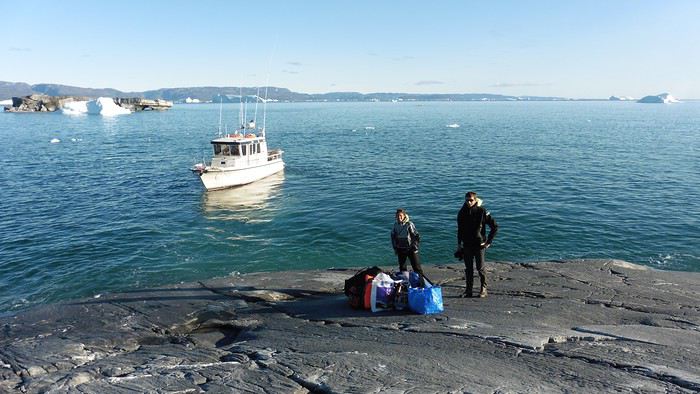
Here we were on the island, in the middle of nowhere, with all our luggage and food to organize, the tent to set up, and the kayaks to inflate—just 10 hours after leaving the Copenhagen hotel. We got to work, bothered by the flies. Despite our head nets, it was barely tolerable—there were so many of them. They swarmed by the dozens into every bag we opened. It was quite mild: 10°C.
Everything was ready by evening, and we were very happy to have completed all these transfers (planes and boat in a single day) as we slipped into our sleeping bags.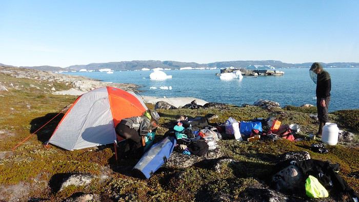
During the night, the wind picked up, and we went out several times to check the tent and kayak anchors. We noticed how bright it was—it was still quite twilight even at 1 AM.
Day 2 5:30 AM wake-up—the south wind was still strong, but since we were heading north, we decided to give it a try anyway.
This was also the moment we loaded the kayaks: since there were only three of us for two double-seater kayaks, we filled the hatch of one kayak, which allowed us to fit all our food. It would have been very difficult if there had been four of us for two kayaks.
Finally, we set off north along the western coast of the island. The conditions were far from ideal—the sea was rough, and the kayaks had a lot of wind resistance. But the main problem was the spray skirt: the gear on deck weighed it down, and the skirt kept coming off… We’d have to deal with it. Barely underway, and whales were already breaking the surface—it was our first time seeing them, and we were very impressed. Too bad the wind didn’t allow for longer contemplation; stopping paddling was impossible with such strong gusts.
We passed a few headlands and even considered stopping due to the conditions. To find some semblance of shelter, we had to hug the coast closely without cutting across the numerous bays, which significantly lengthened the journey. But as the morning went on, the wind died down, and the sea calmed. We spotted several whales and our first seals. It was almost pleasant during the picnic break. By late afternoon, we reached Kangerup Sarqâ Bay, where we had identified a great campsite with a very large beach and a river. But the wind had shifted—it was now coming from the north, making the last hour difficult due to fatigue and headwinds.
The campsite was ideal and beautiful, facing numerous icebergs grounded in the bay.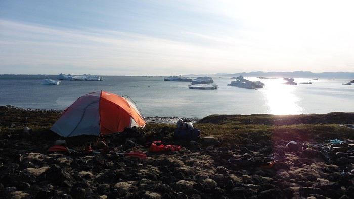
The GPS alerted us to another major drawback of inflatable kayaks: their slowness. It took us 7.5 hours of actual paddling (excluding breaks) to cover 28 km, averaging 3.7 km/h—somewhat disappointing. But we knew this before leaving, and once again, we’d have to make do!
Day 3 Surprise: at 6 AM wake-up, it was raining, foggy, with a south wind, and the sea was choppy even in the bay. It seemed wise to skip paddling, even though stopping on the second day was tough on morale. We went back to sleep, especially since the travel fatigue and the harsh conditions of the previous day had taken their toll.
At 11 AM, the navigation conditions weren’t any better—at the ends of the bay, we saw huge waves crashing onto the rocks, and giving up for the day became obvious. However, the rain had stopped, so we set off for a hike along the large lake bordering the bay. The wind hadn’t let up, and it was quite cold.
The tundra was starting to take on its autumn colors, and the contrast between the white lichens and the red vegetation was stunning. At the lake, we took out the fishing rods and quickly caught two beautiful Arctic char over 50 cm long.
As the afternoon wore on, the sun seemed closer. Along the beach, we gathered driftwood (mostly old planks) to cook our catch in foil over a fire. Eating our own food in such a beautiful place next to a good fire was comforting after the day’s setback.
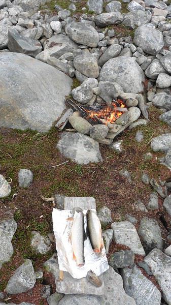
In the middle of the night, an Arctic fox entered the tent’s rear awning. It seemed barely intimidated when we shooed it away with loud shouts and then with stones.
Day 4 6:15 AM wake-up—3°C. We were on the water by 8 AM. The wind had dropped significantly, but the sea was shrouded in fog, and it was very cold in these damp conditions.
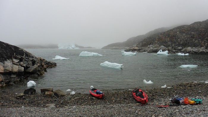
We passed the bay’s headland, Kangea, and headed toward the abandoned village of Agpat. The atmosphere was very austere—we hugged black rocks in fog that limited visibility to 50 meters, revealing large icebergs as we went.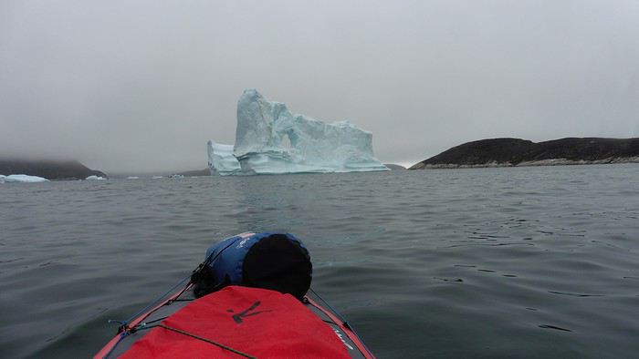
Suddenly, the water’s surface stirred in front of my kayak, and a huge gray back emerged from the sea. The collision was inevitable, but the whale seemed to understand and dove immediately, passing under the kayak and resurfacing a few meters away. I felt the kayak rock in the white foam and quickly paddled to escape the turbulence. What an emotion!
A light wind began to clear the fog, and the sun made beautiful appearances. Despite the cold, we stopped to visit the abandoned village, which left a strange impression. All the houses were still in good condition and wide open—some must have been very spacious in their time. We went back to sea, and in front of the large Kaangerdluk Bay, we hesitated—the headwind was strong, and large waves split the water. The next beach, from the island of Nua where we stopped to think, was over 8 km away. It was barely 2 PM, but caution led us to stop here for the day. We had covered 12 km—exactly the distance needed to stay on schedule. The afternoon was spent hiking on the island’s hills and gathering mussels and wood.
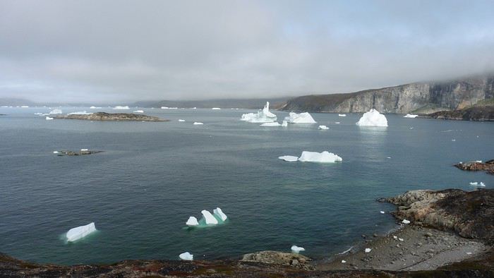
In the evening, we cooked these large Greenlandic mussels over a wood fire and savored them under the beautiful evening light. The weather was now fine, but the thermometer read -5°C in the sun…
Day 5 Bright sunshine, a glassy sea, and -8°C at 6 AM. Everything was green for setting off, even if putting on damp kayaking gear was a bit unpleasant in the cold. It was the first time we’d paddled on a flat sea since the start of the trip, and our average speed increased slightly.
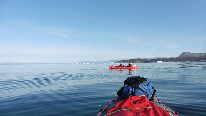
We entered the Smallesund Strait, marking the end of the island’s west coast. We were close to the large Torssukatak Fjord, where two glaciers flow. The access pass to the fjord was very narrow, and numerous ice chunks blocked access to the beaches. The wind had picked up and was now hitting us head-on (again). Just before entering the fjord, we landed on a steep beach made of large pebbles on Oqaitsut Island. It was very cold with the wind, and moving forward became difficult. We decided to stop for the day both because of the conditions and because the next campsite was far away, given how rugged the fjord was.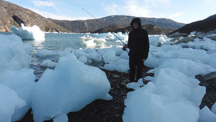
We eventually found a flat spot for the tent despite the steep slope. Even with the wind, the weather was beautiful, and we set off on foot for the northeastern cape of the island, overlooking the fjord. The view was far-reaching and exceptional—up close, the large fjord filled with ice and its steep granite cliffs, and in the distance, the ice cap and glacial walls.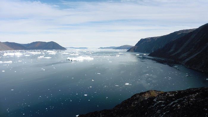
We spotted the village of Qeqertaq, whose network we could pick up, allowing us to check the weather forecast, which was rather good. While securing the kayaks in the evening, I noticed the strange behavior of one kayak at the end of the stage was due to the loss of the skeg—impossible to know where it detached. We’d have to do without it.
Day 6 Still that icy headwind from the northeast. We set off anyway for a long stage to reach the large pass connecting the Torssukatak and Ata Fjords.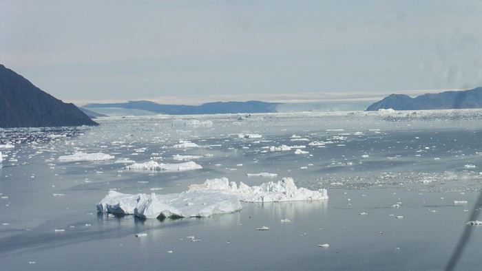
We advanced laboriously along the high cliffs of the fjord’s southern shore. They faced due north and blocked the sun. We felt the cold and dampness of the rock. It was really cold, especially in the extremities. We picnicked on the western cape of Qeqertakavasak Island. The cold didn’t allow us to stop for more than 20 minutes… But the wind dropped, and the sea was now very smooth. It was heavily cluttered with ice between the icebergs and old pack ice. The goal was to reach the large rocky promontory of Anapnuna, wedged between the Kujatdleq and Kangilerngata Glaciers, but the ice made progress difficult. We stopped to gain height on a small island and spot a passage of open water, but all we saw was white—passing seemed impossible. The currents were very complex, and entire sections of ice were being swept in one direction and then another at an impressive speed.
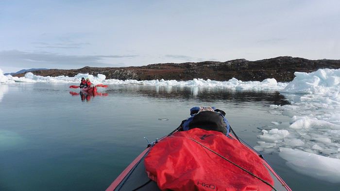
We wandered through this labyrinth until landing on a beach on the small island of Takissut, where we set up camp, exhausted from the 30 km covered and the vigilance required by the abundance of ice. The place was sublime under the evening sun—we were surrounded by ice and mountains, with the Kangilerngata Glacier in the distance. The summer contrasts were striking between the water, icebergs, sky, and flaming tundra—all colors were represented. Absolute calm reigned.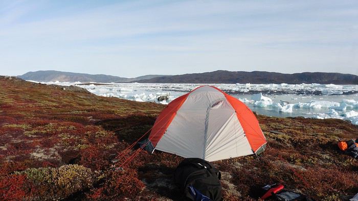
The lack of drinking water at this spot wasn’t too much of a constraint: as soon as we arrived on the beach, we placed containers under the icebergs stranded in the intertidal zone. They were all full by the time we finished setting up.
Day 7 We had to change our plans: we wouldn’t reach the rocky promontory, too well protected by the ice. We set off under the sun for Igdluluarssuit Island. Although we had spotted a passage just before launching, we quickly found ourselves surrounded by ice. It was everywhere, and finding water to paddle became complicated. We tried to force our way in every direction, even retracing our steps. Everything moved at an impressive speed—we were in the middle of a whirlpool of ice.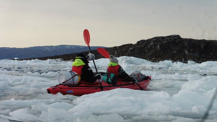
The tension rose, and each boat had its share of big scares. I was trapped against ice floes that dragged me toward an iceberg—the pressure on the kayak was enormous; it was going to capsize or puncture! But with a few strong strokes and paddling against the ice, I managed to free myself from the trap. Barely 10 minutes later, my companions were sandwiched perpendicularly between two icebergs that were closing in. The situation was desperate—the kayak was bending and twisting more and more, but with some strong paddle strokes, it finally freed itself. After these particularly unpleasant moments, we were completely blocked. The drifting ice floes had tightened, and the kayaks were no longer even in the water… The only solution: wait with the kayaks on these floes, which were too thin to walk on (even though we didn’t try). Within minutes, the situation cleared—a waterway opened, and we rushed into it. We paddled with one goal: find a larger pool of water. After going back and forth, our path took shape—we had to force the passage several times, attacking the ice directly with the kayaks, and finally, we escaped the worst of the labyrinth. We reached land on the west side of the island and saw that the rest would be easier. To reach the island, we just had to cross the Arsiviup Ikera Strait, which was lightly cluttered. We reached the eastern cape of the island, ideal for camping, even though we had only paddled for 3 hours. We set up camp and hiked to the island’s summit, which overlooks the entire pass and the glaciers.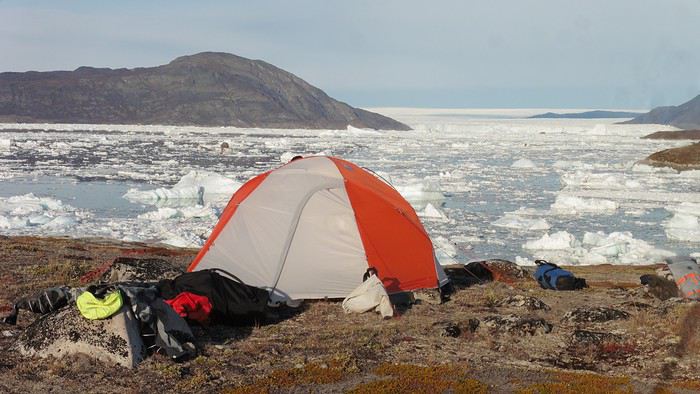
Everything was magnificent, no matter the direction. At 2 PM, we were at the summit—the beauty of the place and the picnic facing the glacier in the sun without wind made us forget the near-disaster from a few hours earlier. It would be impossible to approach the glacier by kayak, but from our summit on foot, it seemed so close, and contemplating it safely on solid ground was a great moment.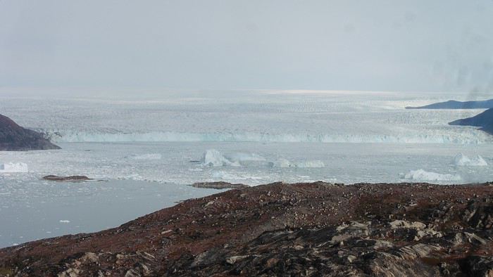
The pass was incredibly complex—everything was in motion, and an impassable passage could become open water within minutes. We were delighted when we returned to camp. A slightly lost whale among the ice accompanied us along the shore. The place was truly beautiful, but the temperature dropped again under the clear sky, preventing us from eating outside.
Day 8 Clear and cold at wake-up: -9°C. The sea had frozen in many places. We hesitated about the rest of the trip—should we start heading back to Ilulissat or linger in the pass, especially to approach the Eqi Glacier? After the incidents of the previous day, we decided to think carefully and paddled to the southern cape of our island to check the ice conditions toward Eqi. The weather had clouded over in the meantime, and the sky was quite gray. At the cape, we spotted the glacier’s wall, still 15 km away.
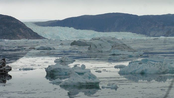
The fjord was quite cluttered, but it seemed passable. However, there was no guarantee the view would be much better 1 km from the glacier than 15 km away, especially since the front was quite active and therefore dangerous. We decided to head south without passing by the glacier. The cold temperatures encountered in the pass also motivated us to move away from the glaciers and the ice cap. We navigated under a threatening sky but without wind. The kayaks cut through the thin layer of ice on the surface with a crinkling paper sound. We reached the Ata campsite in the late afternoon after 5 hours of rowing without a single break…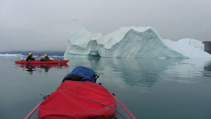
The wind had picked up, and we discovered a nice surprise: a refuge with a table and a comfortable bench lined with mattresses. Facing the worsening weather, we settled in comfortably. The kerosene stove was too complex for our three brains—we couldn’t get it started, too bad, as it was 0°C inside. The rest of the afternoon was spent fishing in the large lake, where we landed a beautiful Arctic char, more than enough for three. A good night’s sleep without the risk of foxes or the sound of a tent shaking in the wind.
Day 9 6 AM wake-up to the sound of rain hitting the cabin. The decision was made looking out the window—wind, rain, and fog obscured the sea: we went back to sleep.
New wake-up, and the rain had stopped—we could go out and stock up on fish. We set off on foot toward the lake, following its western shore. It was very overcast, and the wind encouraged us to keep moving. We made our way to a smaller lake at the end of the large one, where we caught a huge Arctic char. A small clearing brightened the picnic, and we headed back to our cabin.
This 20 km hike kept us busy all day: walking on slippery scree and the micro-relief of the peat bogs took time.
Day 10 The sky was clear, but a light south wind made paddling intense. We set off southeast to reach the opposite shore of the fjord. It was very cold, and it was impossible to stop paddling for even a moment without immediately losing ground due to the wind. We crossed the Kangerluarsuk Fjord. I recognized the cape I had reached on skis in the winter of 2017. We found a nice campsite on the southern shore of the fjord: Uiartag. It wasn’t even noon, but facing this headwind, we preferred to stop here rather than exhaust ourselves for a few extra kilometers. Like the previous ones, this campsite was very comfortable: the ground was covered with a thick layer of lichens and mosses, very pleasant to lie on.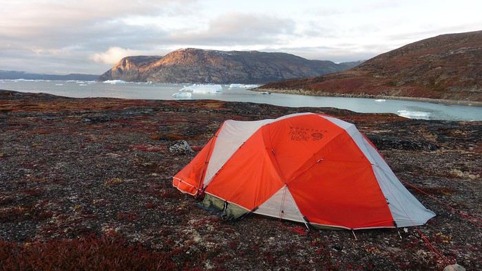
We set off on a hike to the heights of the cape, where the weather alternated between large clearings and snow showers. We noticed the loss of the thermometer, poorly attached to the backpack. On the way back, in the small bay of our beach, a whale swam calmly 10 meters from the shore—a beautiful surprise.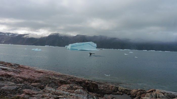
The sky cleared completely, and the temperature dropped as night approached.
We’re setting off as a group of three in two inflatable double-seater kayaks (Gumotex) brought from France. The plan is to spend two weeks circumnavigating Arve Princess Island, located north of Ilulissat in Disko Bay, with a possible boat drop-off at the southern tip of the island.
This seems like a fairly classic route in the area—we found several descriptions online (thanks to the authors). With their help and Google Earth, we identified all potential campsites and entered their coordinates into a GPS. The western part of the island, facing the bay, seems ideal for whale watching, while the more rugged eastern side offers access to several glacial walls. We’re somewhat familiar with the area from two winter expeditions on skis and pulkas.
Plus, the commitment is limited due to the island’s proximity to several small villages, including Qeqertaq, Oqaatsut, and even Ilulissat. In fact, we saw fishing boats almost every day. The distance suits us well: 200 kilometers in 16 full days on site, which should leave some leeway in case of bad weather or for hiking.
We booked our flights in June with Air Greenland to Ilulissat for the last week of August and the first week of September. On both the outbound and return trips, we stayed overnight in Copenhagen. The France-Copenhagen flight was with Air France.
We were allowed 3 x 20 kg in the hold. Each kayak with its accessories fits into a 20 kg bag; the last hold bag is for shared gear: tent, stoves, dry bags… We only brought 1.5 kg of semolina for food. In the end, we had 61 kg of gear, and no excess baggage was charged.
Individual gear (clothes and sleeping bags…) was distributed in the cabin luggage.
For the boat transfer, we contacted an agency: Blue Jay, which gave us a number to call upon arrival.
Day 0: Wednesday, August 22 Departure day. After work, I drove from Gap to Marseille’s Marignane Airport for the first leg of the trip to Copenhagen. I enjoyed the rather mild local temperatures: 35°C in the shade. After a layover in Paris, I arrived at the Copenhagen hotel, located two train stops from the airport, where my companions were already settled. No issues—everyone was on time with their luggage.
Day 1 The flight to Greenland was at 9 AM. We had a layover in Kangerlussuaq, where we changed planes, then stopped in Aasiaat before reaching Ilulissat Airport at 3 PM under beautiful sunshine.
We called Blue Jay for the boat transfer: they could take us to the island as early as 6 PM; otherwise, we’d have to wait until the next day. That left us 3 hours to prepare our gear and, most importantly, do our shopping for the two-week trip—it seemed tight, but we gave it a shot.
A quick taxi ride took us to Pisiffik, where we easily found everything we needed: bread, butter, cheese, cold cuts, rice, pasta, jam, muesli… There was no C fuel or methylated spirits for the stoves, but this time we knew the trick: at Stark, a bit uphill from the town, we found the precious liquids. Two hours later, we filled our dry bags and containers with our purchases, and by 5:30 PM, we met Klaus, the Blue Jay manager, directly at the port.
The vacation seemed to truly begin as we sped by boat through the icebergs toward Arve Princess Island. Forty-five minutes later, we spotted a beach lined with rocks where Klaus dropped us off quickly (he had another transfer to make right after).
Here we were on the island, in the middle of nowhere, with all our luggage and food to organize, the tent to set up, and the kayaks to inflate—just 10 hours after leaving the Copenhagen hotel. We got to work, bothered by the flies. Despite our head nets, it was barely tolerable—there were so many of them. They swarmed by the dozens into every bag we opened. It was quite mild: 10°C.
Everything was ready by evening, and we were very happy to have completed all these transfers (planes and boat in a single day) as we slipped into our sleeping bags.
During the night, the wind picked up, and we went out several times to check the tent and kayak anchors. We noticed how bright it was—it was still quite twilight even at 1 AM.
Day 2 5:30 AM wake-up—the south wind was still strong, but since we were heading north, we decided to give it a try anyway.
This was also the moment we loaded the kayaks: since there were only three of us for two double-seater kayaks, we filled the hatch of one kayak, which allowed us to fit all our food. It would have been very difficult if there had been four of us for two kayaks.
Finally, we set off north along the western coast of the island. The conditions were far from ideal—the sea was rough, and the kayaks had a lot of wind resistance. But the main problem was the spray skirt: the gear on deck weighed it down, and the skirt kept coming off… We’d have to deal with it. Barely underway, and whales were already breaking the surface—it was our first time seeing them, and we were very impressed. Too bad the wind didn’t allow for longer contemplation; stopping paddling was impossible with such strong gusts.
We passed a few headlands and even considered stopping due to the conditions. To find some semblance of shelter, we had to hug the coast closely without cutting across the numerous bays, which significantly lengthened the journey. But as the morning went on, the wind died down, and the sea calmed. We spotted several whales and our first seals. It was almost pleasant during the picnic break. By late afternoon, we reached Kangerup Sarqâ Bay, where we had identified a great campsite with a very large beach and a river. But the wind had shifted—it was now coming from the north, making the last hour difficult due to fatigue and headwinds.
The campsite was ideal and beautiful, facing numerous icebergs grounded in the bay.
The GPS alerted us to another major drawback of inflatable kayaks: their slowness. It took us 7.5 hours of actual paddling (excluding breaks) to cover 28 km, averaging 3.7 km/h—somewhat disappointing. But we knew this before leaving, and once again, we’d have to make do!
Day 3 Surprise: at 6 AM wake-up, it was raining, foggy, with a south wind, and the sea was choppy even in the bay. It seemed wise to skip paddling, even though stopping on the second day was tough on morale. We went back to sleep, especially since the travel fatigue and the harsh conditions of the previous day had taken their toll.
At 11 AM, the navigation conditions weren’t any better—at the ends of the bay, we saw huge waves crashing onto the rocks, and giving up for the day became obvious. However, the rain had stopped, so we set off for a hike along the large lake bordering the bay. The wind hadn’t let up, and it was quite cold.
The tundra was starting to take on its autumn colors, and the contrast between the white lichens and the red vegetation was stunning. At the lake, we took out the fishing rods and quickly caught two beautiful Arctic char over 50 cm long.
As the afternoon wore on, the sun seemed closer. Along the beach, we gathered driftwood (mostly old planks) to cook our catch in foil over a fire. Eating our own food in such a beautiful place next to a good fire was comforting after the day’s setback.
In the middle of the night, an Arctic fox entered the tent’s rear awning. It seemed barely intimidated when we shooed it away with loud shouts and then with stones.
Day 4 6:15 AM wake-up—3°C. We were on the water by 8 AM. The wind had dropped significantly, but the sea was shrouded in fog, and it was very cold in these damp conditions.
We passed the bay’s headland, Kangea, and headed toward the abandoned village of Agpat. The atmosphere was very austere—we hugged black rocks in fog that limited visibility to 50 meters, revealing large icebergs as we went.
Suddenly, the water’s surface stirred in front of my kayak, and a huge gray back emerged from the sea. The collision was inevitable, but the whale seemed to understand and dove immediately, passing under the kayak and resurfacing a few meters away. I felt the kayak rock in the white foam and quickly paddled to escape the turbulence. What an emotion!
A light wind began to clear the fog, and the sun made beautiful appearances. Despite the cold, we stopped to visit the abandoned village, which left a strange impression. All the houses were still in good condition and wide open—some must have been very spacious in their time. We went back to sea, and in front of the large Kaangerdluk Bay, we hesitated—the headwind was strong, and large waves split the water. The next beach, from the island of Nua where we stopped to think, was over 8 km away. It was barely 2 PM, but caution led us to stop here for the day. We had covered 12 km—exactly the distance needed to stay on schedule. The afternoon was spent hiking on the island’s hills and gathering mussels and wood.
In the evening, we cooked these large Greenlandic mussels over a wood fire and savored them under the beautiful evening light. The weather was now fine, but the thermometer read -5°C in the sun…
Day 5 Bright sunshine, a glassy sea, and -8°C at 6 AM. Everything was green for setting off, even if putting on damp kayaking gear was a bit unpleasant in the cold. It was the first time we’d paddled on a flat sea since the start of the trip, and our average speed increased slightly.
We entered the Smallesund Strait, marking the end of the island’s west coast. We were close to the large Torssukatak Fjord, where two glaciers flow. The access pass to the fjord was very narrow, and numerous ice chunks blocked access to the beaches. The wind had picked up and was now hitting us head-on (again). Just before entering the fjord, we landed on a steep beach made of large pebbles on Oqaitsut Island. It was very cold with the wind, and moving forward became difficult. We decided to stop for the day both because of the conditions and because the next campsite was far away, given how rugged the fjord was.
We eventually found a flat spot for the tent despite the steep slope. Even with the wind, the weather was beautiful, and we set off on foot for the northeastern cape of the island, overlooking the fjord. The view was far-reaching and exceptional—up close, the large fjord filled with ice and its steep granite cliffs, and in the distance, the ice cap and glacial walls.
We spotted the village of Qeqertaq, whose network we could pick up, allowing us to check the weather forecast, which was rather good. While securing the kayaks in the evening, I noticed the strange behavior of one kayak at the end of the stage was due to the loss of the skeg—impossible to know where it detached. We’d have to do without it.
Day 6 Still that icy headwind from the northeast. We set off anyway for a long stage to reach the large pass connecting the Torssukatak and Ata Fjords.
We advanced laboriously along the high cliffs of the fjord’s southern shore. They faced due north and blocked the sun. We felt the cold and dampness of the rock. It was really cold, especially in the extremities. We picnicked on the western cape of Qeqertakavasak Island. The cold didn’t allow us to stop for more than 20 minutes… But the wind dropped, and the sea was now very smooth. It was heavily cluttered with ice between the icebergs and old pack ice. The goal was to reach the large rocky promontory of Anapnuna, wedged between the Kujatdleq and Kangilerngata Glaciers, but the ice made progress difficult. We stopped to gain height on a small island and spot a passage of open water, but all we saw was white—passing seemed impossible. The currents were very complex, and entire sections of ice were being swept in one direction and then another at an impressive speed.
We wandered through this labyrinth until landing on a beach on the small island of Takissut, where we set up camp, exhausted from the 30 km covered and the vigilance required by the abundance of ice. The place was sublime under the evening sun—we were surrounded by ice and mountains, with the Kangilerngata Glacier in the distance. The summer contrasts were striking between the water, icebergs, sky, and flaming tundra—all colors were represented. Absolute calm reigned.
The lack of drinking water at this spot wasn’t too much of a constraint: as soon as we arrived on the beach, we placed containers under the icebergs stranded in the intertidal zone. They were all full by the time we finished setting up.
Day 7 We had to change our plans: we wouldn’t reach the rocky promontory, too well protected by the ice. We set off under the sun for Igdluluarssuit Island. Although we had spotted a passage just before launching, we quickly found ourselves surrounded by ice. It was everywhere, and finding water to paddle became complicated. We tried to force our way in every direction, even retracing our steps. Everything moved at an impressive speed—we were in the middle of a whirlpool of ice.
The tension rose, and each boat had its share of big scares. I was trapped against ice floes that dragged me toward an iceberg—the pressure on the kayak was enormous; it was going to capsize or puncture! But with a few strong strokes and paddling against the ice, I managed to free myself from the trap. Barely 10 minutes later, my companions were sandwiched perpendicularly between two icebergs that were closing in. The situation was desperate—the kayak was bending and twisting more and more, but with some strong paddle strokes, it finally freed itself. After these particularly unpleasant moments, we were completely blocked. The drifting ice floes had tightened, and the kayaks were no longer even in the water… The only solution: wait with the kayaks on these floes, which were too thin to walk on (even though we didn’t try). Within minutes, the situation cleared—a waterway opened, and we rushed into it. We paddled with one goal: find a larger pool of water. After going back and forth, our path took shape—we had to force the passage several times, attacking the ice directly with the kayaks, and finally, we escaped the worst of the labyrinth. We reached land on the west side of the island and saw that the rest would be easier. To reach the island, we just had to cross the Arsiviup Ikera Strait, which was lightly cluttered. We reached the eastern cape of the island, ideal for camping, even though we had only paddled for 3 hours. We set up camp and hiked to the island’s summit, which overlooks the entire pass and the glaciers.
Everything was magnificent, no matter the direction. At 2 PM, we were at the summit—the beauty of the place and the picnic facing the glacier in the sun without wind made us forget the near-disaster from a few hours earlier. It would be impossible to approach the glacier by kayak, but from our summit on foot, it seemed so close, and contemplating it safely on solid ground was a great moment.
The pass was incredibly complex—everything was in motion, and an impassable passage could become open water within minutes. We were delighted when we returned to camp. A slightly lost whale among the ice accompanied us along the shore. The place was truly beautiful, but the temperature dropped again under the clear sky, preventing us from eating outside.
Day 8 Clear and cold at wake-up: -9°C. The sea had frozen in many places. We hesitated about the rest of the trip—should we start heading back to Ilulissat or linger in the pass, especially to approach the Eqi Glacier? After the incidents of the previous day, we decided to think carefully and paddled to the southern cape of our island to check the ice conditions toward Eqi. The weather had clouded over in the meantime, and the sky was quite gray. At the cape, we spotted the glacier’s wall, still 15 km away.
The fjord was quite cluttered, but it seemed passable. However, there was no guarantee the view would be much better 1 km from the glacier than 15 km away, especially since the front was quite active and therefore dangerous. We decided to head south without passing by the glacier. The cold temperatures encountered in the pass also motivated us to move away from the glaciers and the ice cap. We navigated under a threatening sky but without wind. The kayaks cut through the thin layer of ice on the surface with a crinkling paper sound. We reached the Ata campsite in the late afternoon after 5 hours of rowing without a single break…
The wind had picked up, and we discovered a nice surprise: a refuge with a table and a comfortable bench lined with mattresses. Facing the worsening weather, we settled in comfortably. The kerosene stove was too complex for our three brains—we couldn’t get it started, too bad, as it was 0°C inside. The rest of the afternoon was spent fishing in the large lake, where we landed a beautiful Arctic char, more than enough for three. A good night’s sleep without the risk of foxes or the sound of a tent shaking in the wind.
Day 9 6 AM wake-up to the sound of rain hitting the cabin. The decision was made looking out the window—wind, rain, and fog obscured the sea: we went back to sleep.
New wake-up, and the rain had stopped—we could go out and stock up on fish. We set off on foot toward the lake, following its western shore. It was very overcast, and the wind encouraged us to keep moving. We made our way to a smaller lake at the end of the large one, where we caught a huge Arctic char. A small clearing brightened the picnic, and we headed back to our cabin.
This 20 km hike kept us busy all day: walking on slippery scree and the micro-relief of the peat bogs took time.
Day 10 The sky was clear, but a light south wind made paddling intense. We set off southeast to reach the opposite shore of the fjord. It was very cold, and it was impossible to stop paddling for even a moment without immediately losing ground due to the wind. We crossed the Kangerluarsuk Fjord. I recognized the cape I had reached on skis in the winter of 2017. We found a nice campsite on the southern shore of the fjord: Uiartag. It wasn’t even noon, but facing this headwind, we preferred to stop here rather than exhaust ourselves for a few extra kilometers. Like the previous ones, this campsite was very comfortable: the ground was covered with a thick layer of lichens and mosses, very pleasant to lie on.
We set off on a hike to the heights of the cape, where the weather alternated between large clearings and snow showers. We noticed the loss of the thermometer, poorly attached to the backpack. On the way back, in the small bay of our beach, a whale swam calmly 10 meters from the shore—a beautiful surprise.
The sky cleared completely, and the temperature dropped as night approached.
Tourist Trophy sur l'île de Man en 2014
Je désire aller avec des amis motards sur l'île de Man en 2014 car je m'y prends trop tard pour 2013.
Au vu des différentes discussions sur le forum, il est vraiment nécessaire de s'y prendre quasiment 1 an à l’avance.
C'est pourquoi je suis d'ores et déjà preneur de toute info concernant le ou les bateaux, le modèle d'hébergement, la durée du séjour sur place, la météo, etc, etc....
Merci à tous ceux qui peuvent m'apporter des infos.
Cordialement
Voyage en France: emploi, logement, coût de la vie, etc?
Bonjour à vous tous,
alors je vous explique le genre d'aventure que moi et mon copain aimerions faire l'an prochain. Nous aurons tous les deux terminés nos études, donc souhaitons aller travailler à l'étranger (France). Moi je chercherai un emploi en éducation spécialisé et mon copain comme maçon. Donc, nous devons trouver une ville qui nous permettra de se trouver un travail dans notre domaine.
Je ne sais aucunement vers quel région/ville m'orienter; plusieurs semblent être assez belles !!! Par contre, nous cherchons une région où le coût de la vie n'est pas trop cher (pour se trouver un logement au prix raisonnable, bouffe raisonnable), transport en commun, sécuritaire, facile à traverser dans d'autres pays pour visiter (critère moins important).
Si vous avez vécu une expérience du genre (j'habite au Québec, sois dit en passant), ne vous gênez pas pour en faire part. En espérant avoir quelques conseils. Merci à l'avance 🙂
alors je vous explique le genre d'aventure que moi et mon copain aimerions faire l'an prochain. Nous aurons tous les deux terminés nos études, donc souhaitons aller travailler à l'étranger (France). Moi je chercherai un emploi en éducation spécialisé et mon copain comme maçon. Donc, nous devons trouver une ville qui nous permettra de se trouver un travail dans notre domaine.
Je ne sais aucunement vers quel région/ville m'orienter; plusieurs semblent être assez belles !!! Par contre, nous cherchons une région où le coût de la vie n'est pas trop cher (pour se trouver un logement au prix raisonnable, bouffe raisonnable), transport en commun, sécuritaire, facile à traverser dans d'autres pays pour visiter (critère moins important).
Si vous avez vécu une expérience du genre (j'habite au Québec, sois dit en passant), ne vous gênez pas pour en faire part. En espérant avoir quelques conseils. Merci à l'avance 🙂
Avis des Nord-Américains sur l'île de Madagascar?
Bonjour,
Je veux voyager à Madagascar bientôt, soit en juillet ou en décembre. J'aimerais avoir les avis des nords américains qui sont déjà allés là-bas tout d'abord sur la meilleure période pour les vols puisque ce n'est pas donné en partance du Canada ou des États-Unis 😛. Je n'ai pas vraiment trouver d'informations qui viennent des gens d'ici. Est-ce que c'est quand même une bonne destination pour voyager (découverte, détente, vacances, etc.) et non pas venir en tant qu'humanitaire ou en travailleur etc? Est-ce que c'est genre Haiti ou La République?
Ensuite, avez-vous des conseils ou des opinions sur ce qui est bien et moins bien pour le voyage dans ce pays?
Voilà pour commencer mais je poserais plein de questions au fur et à mesure.
Merci!😉
Première croisière du Bleu de France aux Caraïbes: qui en revient?
Bonjour
La 1ére croisière sur le Bleu de France aux Caraîbes a eu lieu la semaine dernière,
qui revient de cette croisière et peut nous donner des informations ?
merci
Aimez-vous la France et les Francais?
Voyager pourquoi?
1- Pour quitter ce pays
Pour ma part, je commence vraiment à prendre la France et les francais en grippe.....En effet, ce pays me gonfle de part ce conformisme, ce conservatisme et cet immobilisme qui l'habite, cette impossibilité de se renouveler et de changer les choses.....on baigne dans une consommation outrancière et une société d'apparat ou les gens te jugent en fonction de ta catégorie socio professionnelle....dans qu'elle case vont-ils pouvoir te mettre !!!! Donc tu n'existes pas pour ce que tu es mais bien plus pour ce que tu représente.... Alors moi j'ai décidé de ne faire partie d'aucune case..... Les francais m'emmerdent, je les trouve BOF...je n'ai plus rien à voir avec mes potes (de longues date pourtant..) qui ne me parlent que de leurs gamins, des couches, des bib, et leur SACRO SAINT boulot!!!! PASSIONANT!!!! D'ailleurs il suffit de voir la réputation que l'on a à l'étranger.....de gens désagréables, jamais contents, agréssifs qui font toujours la geule.....il faudra écrire un post là dessus!!! Je m'emmerde royal ici. Je part m'expatrier l'année prochaine en amérique centrale, ou je trouve les gens nettement plus ouverts, tolérants, AGREABLE..... Les voyages, c'est tellement passionant...une vraie quète intérieure pour ma part, c'est ma raison de vivre. Sans voyage, je meurt. On découvre tellement de choses, de gens, on fait des rencontres extraordinaires, ca nous remet en place quelques fois et ca fait du bien, c'est ce que je veux...être remise à ma place. Apprendre à relativiser, apprendre à comprendre les différences, la nature humaine dans toute sa complexité, diversité....expériences humaines qui te mènent vers une autre dimension: celle où tu es à la source, à l'essentiel. Un voyage c'est avant tout quelque chose de vrai ou tu es tout nu face au monde...tu es toi et non pas le directeur d'entreprise, la secrétaire, le commercial.....En voyage tu ne peux pas te mentir à toi même, tu ne peux pas mentir non plus. C'est toi face au monde. Et lorsque les rencontres sont là au rendez vous, alors là tu sais que ces moments magiques sont d'une intense vérité car tu auras était toi même et tu auras été apprécié pour ce que tu es réellement au plus profond de toi....et ca n'a pas de prix.
Et vous aimez vous votre pays?????????????????????????????????????????????????????????
1- Pour quitter ce pays
Pour ma part, je commence vraiment à prendre la France et les francais en grippe.....En effet, ce pays me gonfle de part ce conformisme, ce conservatisme et cet immobilisme qui l'habite, cette impossibilité de se renouveler et de changer les choses.....on baigne dans une consommation outrancière et une société d'apparat ou les gens te jugent en fonction de ta catégorie socio professionnelle....dans qu'elle case vont-ils pouvoir te mettre !!!! Donc tu n'existes pas pour ce que tu es mais bien plus pour ce que tu représente.... Alors moi j'ai décidé de ne faire partie d'aucune case..... Les francais m'emmerdent, je les trouve BOF...je n'ai plus rien à voir avec mes potes (de longues date pourtant..) qui ne me parlent que de leurs gamins, des couches, des bib, et leur SACRO SAINT boulot!!!! PASSIONANT!!!! D'ailleurs il suffit de voir la réputation que l'on a à l'étranger.....de gens désagréables, jamais contents, agréssifs qui font toujours la geule.....il faudra écrire un post là dessus!!! Je m'emmerde royal ici. Je part m'expatrier l'année prochaine en amérique centrale, ou je trouve les gens nettement plus ouverts, tolérants, AGREABLE..... Les voyages, c'est tellement passionant...une vraie quète intérieure pour ma part, c'est ma raison de vivre. Sans voyage, je meurt. On découvre tellement de choses, de gens, on fait des rencontres extraordinaires, ca nous remet en place quelques fois et ca fait du bien, c'est ce que je veux...être remise à ma place. Apprendre à relativiser, apprendre à comprendre les différences, la nature humaine dans toute sa complexité, diversité....expériences humaines qui te mènent vers une autre dimension: celle où tu es à la source, à l'essentiel. Un voyage c'est avant tout quelque chose de vrai ou tu es tout nu face au monde...tu es toi et non pas le directeur d'entreprise, la secrétaire, le commercial.....En voyage tu ne peux pas te mentir à toi même, tu ne peux pas mentir non plus. C'est toi face au monde. Et lorsque les rencontres sont là au rendez vous, alors là tu sais que ces moments magiques sont d'une intense vérité car tu auras était toi même et tu auras été apprécié pour ce que tu es réellement au plus profond de toi....et ca n'a pas de prix.
Et vous aimez vous votre pays?????????????????????????????????????????????????????????
MSC Orchestra: transatlantique du 2 avril Fort-de-France - Marseille
Bonjour tout le monde. 😎
Il y aurait il des participants dans le groupe à la Transat retour du MSC
Orchestra du 02 au 18 avril 2016
Martinique / Marseille?
Ce serait vraiment sympa d'échanger ensemble sur le sujet, et pourquoi pas se rencontrer pour apero et autres sur le bateau 🙂
De plus, merci d'avance à tous pour vos avis et conseils, car ce sera une premiere transat pour nous
Itinéraire de 3 semaines dans le sud de la France
Bonjour! J'aimerais avoir votre avis sur la planification de notre voyage de 3 semaines dans le sud de la France. Je voudrais m'assurer que ce n'est pas trop surchargé. Merci de me donner votre avis ou tout autre suggestion!
11 septembre : départ de Québec 12 septembre : arrivée à Nice + visite de Nice 13 septembre : Monaco 14 septembre : Nice + Menton 15 septembre : Cannes + Grasse 16 septembre : Fréjus + Saint-Tropez 17 septembre : Marseille (Port + Calanques) 18 septembre : Aix-en-Provence 19 septembre : Arles 20 septembre : Parc naturel régional de Camargue 21 septembre : Avignon 22 septembre : Nîmes + Pont du Gard 23 septembre : Montpellier 24 septembre : Narbonne 25 septembre : Carcassonne 26 septembre : Parc national de Cévènnes 27 septembre : Quelque chose entre le parc et Lyon 28 septembre : Lyon 29 septembre : Chamonix 30 septembre : Grenoble 1er octobre : Parc du Verdon 2 octobre : Nice 3 octobre : retour au Québec
11 septembre : départ de Québec 12 septembre : arrivée à Nice + visite de Nice 13 septembre : Monaco 14 septembre : Nice + Menton 15 septembre : Cannes + Grasse 16 septembre : Fréjus + Saint-Tropez 17 septembre : Marseille (Port + Calanques) 18 septembre : Aix-en-Provence 19 septembre : Arles 20 septembre : Parc naturel régional de Camargue 21 septembre : Avignon 22 septembre : Nîmes + Pont du Gard 23 septembre : Montpellier 24 septembre : Narbonne 25 septembre : Carcassonne 26 septembre : Parc national de Cévènnes 27 septembre : Quelque chose entre le parc et Lyon 28 septembre : Lyon 29 septembre : Chamonix 30 septembre : Grenoble 1er octobre : Parc du Verdon 2 octobre : Nice 3 octobre : retour au Québec
La France qui souffre...
Sanary sur Mer, un samedi maussade de Novembre...
Une pâtisserie à la vitrine alléchante...
Deux femmes, la quarantaine bien maquillée... Un soupçon de parfum, une silhouette raffinée... Des lunettes et sacs discrètement griffés...
- Tiens des macarons ! Tu savais que Ladurée avait ouvert une boutique à Saint Tropez ? - Ah non ! Elle est où ? - Tu vois la boutique de parfum sur le port ? Ils se sont installés là. - Pfff ! De toutes les façons, il n'y a de macarons que ceux d'Hermé... Alors...
Morale : Jean-François, arrête avec tes pains au chocolat ! T'es vraiment trop ringard...
Morale bis : Merci d'adresser vos dons aux "Macarons du coeur, rue Sainte Geneviève, 11111 Les Champs Catalauniques " (J'avoue un faible pour le parfum Fraise des bois bien que le goût Paprika soit de nouveau tendance...)
Deux femmes, la quarantaine bien maquillée... Un soupçon de parfum, une silhouette raffinée... Des lunettes et sacs discrètement griffés...
- Tiens des macarons ! Tu savais que Ladurée avait ouvert une boutique à Saint Tropez ? - Ah non ! Elle est où ? - Tu vois la boutique de parfum sur le port ? Ils se sont installés là. - Pfff ! De toutes les façons, il n'y a de macarons que ceux d'Hermé... Alors...
Morale : Jean-François, arrête avec tes pains au chocolat ! T'es vraiment trop ringard...
Morale bis : Merci d'adresser vos dons aux "Macarons du coeur, rue Sainte Geneviève, 11111 Les Champs Catalauniques " (J'avoue un faible pour le parfum Fraise des bois bien que le goût Paprika soit de nouveau tendance...)
Le Costa Concordia s'échoue près de l'île Giglio au sud de la Toscane (13 janvier 2012)
Semble-t-il que le Costa Corcordia s'est échoué près de l'Ile Giglio au sud de la Toscane, les passagers et l'équipage ont été évacués.