

Travel guide · Ecuador
Ecuador
One of the smallest countries in Latin America, yet a complete "summary" of what the continent has to offer: the Pacific coast, the Andes with high plateaus and volcanoes, the Amazon rainforest, and a unique archipelago—the Galápagos Islands.
Introduction to Ecuador
Ecuador is the smallest of the Andean countries, which allows you to travel from the level of the Pacific Ocean to the Amazon basin in less than 300 kilometres via mountain ranges sometimes exceeding 6,000 m. The country is made up of three distinct regions:…
Regions of Ecuador
Pacific Coast

The Costa (the coast) is this vast fertile coastal plain that runs along the Pacific. It is also one of Ecuador's wealthiest regions and the most populated, with one in two Ecuadorians living here, particularly around Guayaquil, the country's largest urban area with nearly 3 million inhabitants. However, this part of the country is visited far less than the rest of the territory.
The Andes

The Sierra is the central part of the country, at high altitude with numerous volcanoes exceeding 5,000 m, arranged in two parallel cordilleras between which lies a high plateau around 2,500 m. This is where Quito was built, along with other cities like Cuenca. Rich in heritage, nature, landscapes, and all kinds of activities, the Andean part of Ecuador remains the most visited region.
Ecuadorian Amazon
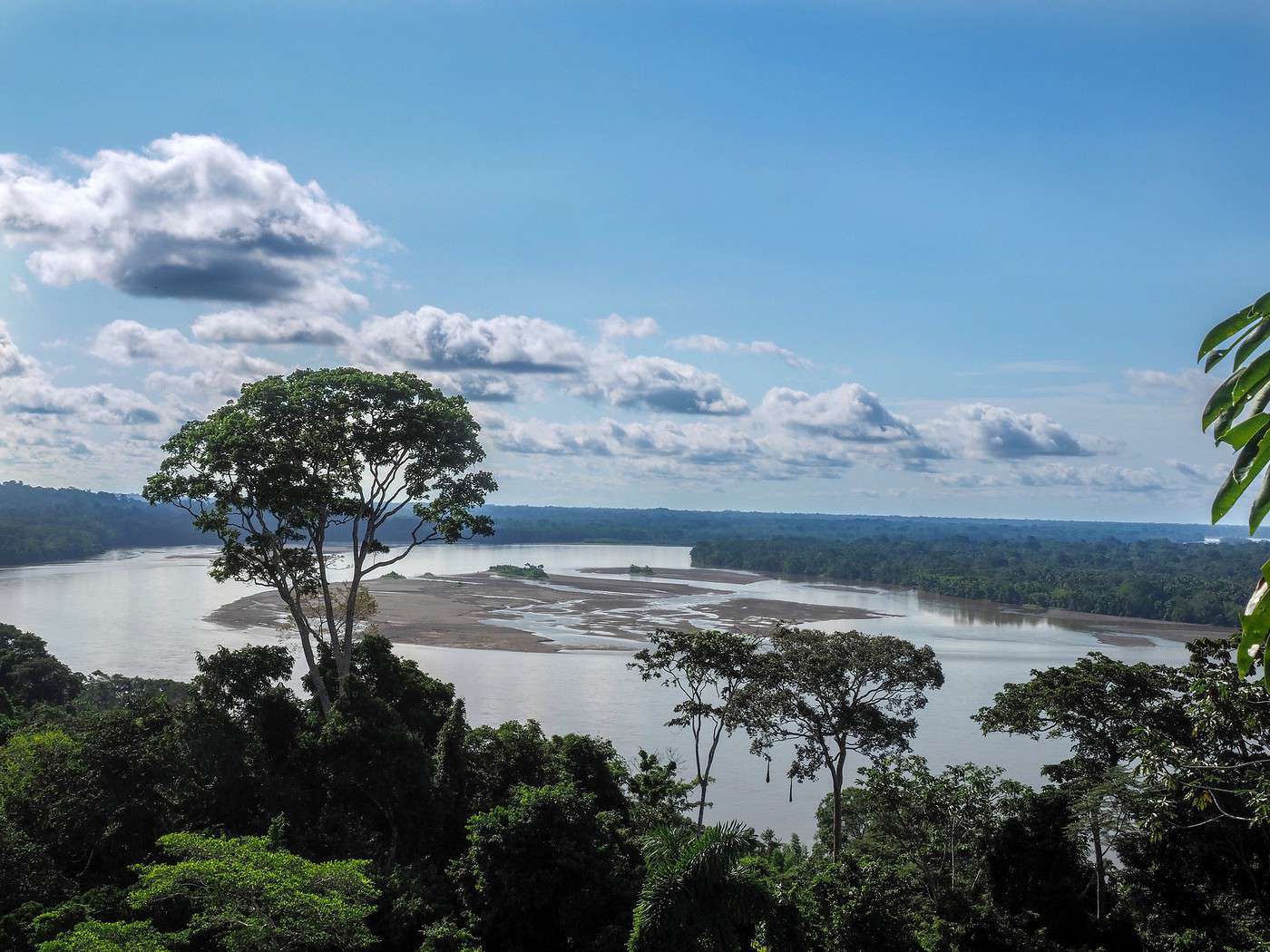
The Ecuadorian Amazon (el Oriente) covers about half of the country's surface area. A major advantage is that, since Ecuador is small, access to the jungle—at least in the north—is easier and quicker than elsewhere. A simple day's bus ride from Quito is enough to reach it, and from there, you can organize a stay with a guide or even independently at times.
Galapagos

A UNESCO World Heritage site, the Galapagos archipelago is a unique destination in terms of the marine and terrestrial wildlife it offers visitors. Located nearly a thousand kilometers off the Ecuadorian coast, this separate world bears no resemblance to the rest of the country, including in terms of tourism and especially the budget required to explore it...
Galapagos
A UNESCO World Heritage site, the Galapagos archipelago is a unique destination for its marine and terrestrial wildlife. Located nearly a thousand kilometers off the coast of Ecuador, this separate world bears no resemblance to the rest of the country—especially in terms of tourism and the budget required to explore it...
Overview of the Galapagos
Geography, Climate, and Environment of the Galapagos
Society, Culture and Customs of the Galapagos
Getting to the Galapagos
Getting Around the Galapagos
Things to See and Do in the Galápagos
Choosing Your Galapagos Cruise
Accommodation and Food in the Galapagos
Entry Requirements, Money and Budget for the Galapagos
Other practical information for the Galápagos
View guide page: GalapagosAdditional Resources on VoyageForum
Baltra
This is where the main airport of the Galapagos is located.
View guide page: BaltraOverview
Baltra is an uninhabited island near Santa Cruz, which is the most populated in the archipelago. It is the only one not part of the Galapagos National Park. Its sole purpose is to host the main airport of the Galapagos Islands, Seymour Airport, which means there is nothing else (accommodations or otherwise) on the island.
Key Facts
- Type of place: island.
- Tourist interest: (worth a stop if you are in the area).
- Location: north of Santa Cruz.
- Local time: .
- Distances: Puerto Ayora (47 km to the south).
- Population: no permanent population.
- Area: 27 km².
- Highest point:
- Website:
Seymour Airport
This is the main air access point to the archipelago, with nearly 1 million passengers per year. Its origins date back to World War II, when it was used by the U.S. Air Force.
- Name: Seymour
- IATA code: GPS
- Hub: no
- Number of terminals: 1
- Annual passenger capacity:
- Passenger traffic: 956,000 (2013)
- Distance to town: about forty kilometers from Puerto Ayora
- Website:
Services
Transportation
To get from the airport to Santa Cruz and Puerto Ayora, you first take a public bus to the "Muelle," which is the dock on Baltra Island. From there, a boat takes you to Santa Cruz in 10 minutes, then a bus to Puerto Ayora in 45 minutes. Everything is synchronized, and the total journey takes roughly 1 hour and 15 minutes for $3.
What to See and Do
There is nothing in particular to see or do on Baltra, as the island’s sole purpose is to host the airport.
Additional Information
Bartolome
It's a small but well-visited island where you can see penguins and tortoises among other wildlife, set in a striking, barren landscape. You can also swim and go diving here.
View guide page: BartolomeOverview of Bartolome
It's a small but well-visited island where you can see penguins and tortoises among other wildlife, set in a striking, barren landscape. You can also swim and go diving here.
Key Facts
- Type of place: island.
- Tourist interest: (recommended).
- Location:
- Local time:
- Population:
- Area: 1.2 km².
- Highest point: 114 m.
- Coastline:
History of Bartolome
Island Environment
Wildlife and Vegetation
Precautions
What to See and Do in Bartolome
Nearby Attractions
Climate and Weather in Bartolome
Transportation
Getting There
Getting Around
Accommodation
Dining
Useful Addresses
- == Additional Information
Española
A fairly remote spot in the archipelago, but it offers incredibly rich wildlife, especially for birdwatching. Diving is also popular here.
View guide page: EspañolaOverview of Española
This is a fairly remote spot in the archipelago, but it offers incredibly rich wildlife, especially for birdwatching. Diving is also popular here.
Key Facts
- Type of place: island.
- Tourist interest: (worth seeing).
- Location:
- Local time:
- Population:
- Area: 60 km².
- Highest point: 206 m.
- Coastline:
History of Española
Island Environment
Wildlife and Flora
Precautions
What to See and Do in Española
Nearby
Climate and Weather in Española
Transportation
Getting There
Getting Around
Accommodation
Dining
Useful Addresses
- == Additional Information
Fernandina
The westernmost island in the archipelago. Iguanas among lava fields and colonies of penguins, sea lions, and seals.
View guide page: FernandinaOverview of Fernandina
This is the westernmost island in the Galapagos archipelago. You can see iguanas among the lava fields and colonies of penguins, sea lions, and seals.
Key Facts
- Type of place: island.
- Tourist interest: (worth seeing).
- Location:
- Local time:
- Population:
- Area: 642 km².
- Highest point: 1,476 m.
- Coastline:
History of Fernandina
Island Environment
Wildlife and Flora
Precautions
What to See and Do on Fernandina
Nearby
Climate and Weather on Fernandina
Transportation
Getting There
Getting Around
Accommodation
Food
Useful Addresses
- == Additional Information
Genovesa
This partly forested island in the northeast of the Galapagos archipelago is home to many bird species.
View guide page: GenovesaOverview of Genovesa
This partly forested island in the northeast of the Galapagos archipelago is home to many bird species.
Key Facts
- Type of place: island.
- Tourist interest: (worth a stop if you are in the area).
- Location:
- Local time:
- Population:
- Area: 14 km².
- Highest point: 64 m.
- Coastline:
History of Genovesa
Island Environment
Wildlife and Flora
Precautions
What to See and Do in Genovesa
In the Surrounding Area
Climate and Weather in Genovesa
Transportation
Getting There
Getting Around
Accommodation
Dining
Useful Addresses
- == Additional Information
Isabela
It is the largest island, with Puerto Villamil as its main town. It is home to half a dozen volcanoes. You can take several excursions on Isabela without needing to join a boat tour.
View guide page: IsabelaOverview of Isabela
It is the largest island in the Galapagos, with Puerto Villamil as its main town. It is home to half a dozen volcanoes. You can take several excursions on Isabela without needing to join a boat tour.
Key Facts
- Type of place: island.
- Tourist interest: (worth seeing).
- Location:
- Local time:
- Main town: Puerto Villamil.
- Population: 2,200 inhabitants (2012).
- Area: 4,588 km².
- Highest point: 1,707 m.
- Coastline:
History of Isabela
Island Environment
Wildlife and Flora
Precautions
What to See and Do on Isabela
In the Surrounding Area
Climate and Weather on Isabela
Transportation
Getting There
Getting Around
Accommodation
Food
Useful Addresses
Additional Information
San Cristobal (Galapagos)
This is the easternmost island, home to Puerto Baquerizo Moreno, the "capital" of the Galapagos. Part of the island can be explored independently, and diving is possible here.
View guide page: San Cristobal (Galapagos)Overview of San Cristobal
This is the easternmost island in the Galapagos. It is home to Puerto Baquerizo Moreno, the "capital" of the archipelago. Part of the island can be explored independently, and diving is possible here.
Key Facts
- Type of place: island.
- Tourist interest: (worth seeing).
- Location:
- Local time:
- Main town: Puerto Baquerizo Moreno (4,900 inhabitants).
- Population: 5,600 inhabitants (2012).
- Area: 558 km².
- Highest point: 730 m.
- Coastline:
History of San Cristobal
Island Environment
Wildlife and Flora
Precautions
What to See and Do in San Cristobal
In the Area
Climate and Weather in San Cristobal
Transportation
Getting There
Getting Around
Accommodation
Dining
Useful Addresses
Additional Information
San Salvador (Galápagos)
This land—also called Santiago—is home to a wide variety of wildlife (birds, seals, tortoises, etc.).
View guide page: San Salvador (Galápagos)Overview of San Salvador
This land—also called Santiago—is home to a wide variety of wildlife (birds, seals, tortoises, etc.).
Key facts
- Type of place: island.
- Tourist interest: (worth a stop if you are in the area).
- Location:
- Local time:
- Population:
- Area: 585 km².
- Highest point: 907 m.
- Coastline:
History of San Salvador
Island environment
Wildlife and flora
Precautions
What to see and do in San Salvador
In the surrounding area
Climate and weather in San Salvador
Transportation
Getting there
Getting around
Accommodation
Food
Useful addresses
- == Additional information
Santa Cruz (Galapagos)
This is the most populated island, with Puerto Ayora as its tourist hub and the main base for organizing excursions. Diving and hiking are popular here, offering opportunities to discover the local wildlife and volcanic landscapes.
View guide page: Santa Cruz (Galapagos)Overview of Santa Cruz
This is the most populated island in the Galapagos, with Puerto Ayora as its tourist hub and the main base for organizing excursions. Diving and hiking are popular here, offering opportunities to discover the local wildlife and volcanic landscapes.
Key Facts
- Type of place: island.
- Tourist interest: (worth seeing).
- Location:
- Local time:
- Main locality: Puerto Ayora (12,000 inhabitants)
- Population: 15,701 inhabitants (2017).
- Area: 986 km².
- Highest point: 864 m.
- Coastline:
- Website: https://www.galapagos.org/santa-cruz
History of Santa Cruz
Island Environment
Wildlife and Flora
Precautions
What to See and Do on Santa Cruz
In the Surroundings
Climate and Weather on Santa Cruz
Transportation
Getting There
Getting Around
Accommodation
Food
Useful Addresses
Further Information
Santa Fé (Galapagos)
Cactus forests, cliffs, birds, iguanas, and sea lions on this small island between Santa Cruz and San Cristóbal.
View guide page: Santa Fé (Galapagos)Overview of Santa Fé
Cactus forests, cliffs, birds, iguanas, and sea lions on this small island between Santa Cruz and San Cristóbal.
Key facts
- Type of place: island.
- Tourist interest: (worth seeing).
- Location: between Santa Cruz and San Cristóbal islands.
- Local time:
- Population: uninhabited.
- Area: 24 km².
- Highest point: 259 m.
- Coastline:
- Website: https://www.galapagos.org/santa-fe
History of Santa Fé
Island environment
Wildlife and flora
Precautions
What to see and do on Santa Fé
In the surrounding area
Climate and weather on Santa Fé
Getting around
How to get there
Getting around
Where to stay
Where to eat
Useful addresses
- == Additional information
Wolf
A tiny mountainous island home to numerous birds, iguanas, seals, sharks, and whales.
View guide page: WolfOverview of Wolf
It's a tiny mountainous island home to numerous birds, iguanas, seals, sharks, and whales.
Key Facts
- Type of place: island.
- Tourist interest: (worth a stop if you are in the area).
- Location:
- Local time:
- Population: uninhabited.
- Area: 1.3 km².
- Highest point: 253 m.
- Coastline:
- Website: https://www.galapagos.org/wolf
History of Wolf
Island Environment
Wildlife and Flora
Precautions
What to See and Do on Wolf
In the Surrounding Area
Climate and Weather on Wolf
Transportation
Getting There
Getting Around
Accommodation
Food
Useful Addresses
- == Additional Information
Overview of the Galapagos
A UNESCO World Heritage site, the Galapagos Archipelago is a unique destination for its marine and terrestrial wildlife. Located nearly a thousand kilometres off the Ecuadorian coast, this separate world bears no resemblance to the rest of the country,…
Geography, Climate, and Environment of the Galapagos
Environment
Physical Geography of the Region
Wildlife and Flora
Natural Zones
Climate
The Galapagos have a highly variable climate influenced by different marine currents. From January to May, the coasts experience showers, while the interior sees very little rain. For the rest of the year, there is no rain, but coastal fog (garúa) occurs, while the highlands, also misty, receive rainfall. Overall, the beginning of the year remains the best time to visit.
Best Climate Period
| Jan. | Feb. | Mar. | Apr. | May | Jun. | Jul. | Aug. | Sep. | Oct. | Nov. | Dec. | |
|---|---|---|---|---|---|---|---|---|---|---|---|---|
| Climate |
: very favorable | : favorable | : moderately favorable | : unfavorable.
Sea Temperature Throughout the Year
| Jan. | Feb. | Mar. | Apr. | May | Jun. | Jul. | Aug. | Sep. | Oct. | Nov. | Dec. | |
|---|---|---|---|---|---|---|---|---|---|---|---|---|
| Puerto Baquerizo | 25 | 26 | 27 | 27 | 26 | 25 | 24 | 23 | 23 | 23 | 23 | 24 |
Climate Data
Society, Culture and Customs of the Galapagos
Key Historical Dates
- 1535: The uninhabited archipelago, though known to indigenous peoples of the continent, is discovered by the Spanish.
- 16th–17th century: The islands serve as a stopover for pirates and privateers of the era.
- 1822: Ecuador gains independence from Spain.
- 1832: The Ecuadorian government officially takes possession of the Galapagos, naming them the "Archipelago of Ecuador." Gradual arrival of migrants from the mainland.
- 1835: Naturalist Charles Darwin visits, studying the fauna and flora following other scientists who had been interested in the archipelago since the late 18th century.
- Mid-19th century: The Galapagos become a mooring point for whalers and oil tankers.
- Late 19th century: Part of the archipelago serves as a penal colony until 1959.
- 1930s–1960s: To address the small population, Quito’s government begins a settlement policy for the archipelago.
- 1959: A biological research station is established on Santa Cruz. Shortly after, the archipelago becomes a national park.
- 1970s: Tourism begins, and the first air links with the mainland are opened.
- 1973: The archipelago is granted provincial status by decree.
- 1978: The entire Galapagos archipelago is inscribed as a UNESCO World Heritage Site.
- 2000: As in the rest of the country, the US dollar becomes the new currency.
- 2001: At the start of the year, five islands are threatened by an oil spill following the grounding of a tanker off San Cristobal.
- 2007: UNESCO places the Galapagos on the list of World Heritage in Danger to enhance its protection.
Society
Population
Economy
Customs and Traditions
Local Traditions
Regional Languages
Festivals and Celebrations
Books, Films and Music
Getting to the Galapagos
By air
The Galapagos, or rather the islands Baltra and San Cristobal, are only accessible from continental Ecuador with flights from Quito or Guayaquil operated by the three airlines: Avianca Ecuador, Lan Ecuador, and TAME.
While domestic flights in the country are generally not very expensive, the same cannot be said for access to the Galapagos, which is quite costly for foreign visitors who face a surcharge compared to nationals. For this route, expect at least $200 one way (for a 1.5 to 2-hour flight), especially since local travel agencies regularly block seat allocations for their clients, making it difficult for individual travelers to find good deals. Note that students may be eligible for a discount.
Seymour Airport
On Baltra. This is the main air access point to the archipelago, handling nearly 1 million passengers per year. Its origins date back to World War II when it was used by the U.S. Air Force. The airport is located on the uninhabited island of Baltra, adjacent to Santa Cruz (the most populated island), which is the only one not part of the Galapagos National Park.
San Cristobal Airport
On the island San Cristobal. This is the second airport in the archipelago, opened in 1986 for convenience, as it is directly near Puerto Baquerizo Moreno, the "capital" of the Galapagos.
By sea
There are no ferry routes between the Galapagos and the mainland. As for supply boats departing from Guayaquil or elsewhere, they are not authorized to carry passengers.
Sailing
For sailors wishing to visit the archipelago with their yacht, be aware that maritime access and movement within the marine park are highly regulated. It is essential to gather information beforehand, starting with the official Galapagos Park website.
Getting Around the Galapagos
About Getting Around
Across the archipelago, it’s important to know that only five islands are inhabited and many others or sites are regulated or off-limits without supervision. The populated islands are Baltra (uninhabited but home to Seymour Airport), Floreana (100 residents), Isabela (2,200 residents), San Cristobal (5,600 residents), and Santa Cruz (15,000 residents). In short, since people can’t travel outside these, the options for getting around on your own in the Galapagos remain quite limited.
On the (Inhabited) Islands
You can choose between the bus (Santa Cruz, Isabela, San Cristobal), taxi (Santa Cruz, San Cristobal), or walking. Note that you can also rent bikes (or even a horse) on Santa Cruz for around $10 a day.
Between the Islands
Inhabited Islands
There are sea and air links between the islands;
By air: Small airlines Emetebe and Saero operate flights with planes seating fewer than 10 passengers. They connect Baltra to Isabela or San Cristobal, plus San Cristobal to Isabela—three routes they run daily. Fares are steep, starting at $130 per flight (foreign rate) with a 9 kg baggage allowance.
By boat: Small regular boats also serve San Cristobal, Santa Cruz, Isla Isabela, and occasionally Floreana. Prices are high here too, with even the shortest trips costing at least $30. Note that you can also charter a boat for these same routes at negotiable rates.
Other Islands
Visits are regulated and require organized boat tours. So, the question of transport doesn’t arise for these.
Accommodation and Food in the Galapagos
Accommodation
For accommodation, the archipelago offers homestays (including if you just want to pitch a tent) and small hotels on the islands of Isabela, San Cristobal, Floreana, and Santa Cruz (especially in Puerto Ayora). Of all these, Santa Cruz has the most capacity. Budget around $20 for a double room at the lower end. In peak season (July-August or Christmas), it may be useful to book ahead. Also note that many cruises include nights on board in their rates, which can be a good solution for both accommodation and savings.
Food
No problem finding food—you can find small eateries and eat for around $4 or $5. It’s also worth noting that many cruises include meals in their rates.
Other practical information for the Galápagos
Precautions
There are no risks in the archipelago, including health-related ones, except for basic precautions if you venture alone into nature in the few (rare) permitted areas.
Luggage and equipment to bring
Pack light clothing for all seasons, plus something warmer for evenings, as well as rain and sun protection. Bring binoculars for wildlife observation. Since prices are higher in the Galápagos than on the mainland, you might also consider buying some items before arriving.
Communications
Telephone
International dialling code: (00 +) 593.
Internet
Post
Time difference
Local time: for the Galápagos.
In terms of "local time," the archipelago is separate from the mainland part of the country. The Galápagos are on GMT-6, meaning 7 hours behind France in winter and 8 hours behind in summer. The rest of Ecuador is on GMT-5, which is one hour ahead of the Galápagos.
Electricity
120 V (60 Hz), like the rest of the country, with "American" plugs (officially types A and B), so you’ll need an adapter for French plugs.
Opening hours
Laundries
French language use
When it comes to foreign languages spoken in the archipelago, English dominates as usual, while French is almost unheard of. In short, it’s best to have at least a basic grasp of Spanish, or English as a backup.
Entry Requirements, Money and Budget for the Galapagos
Entry Requirements
People
For a leisure trip, the entry requirements are the same as for the rest of Ecuador. For French, Canadian, and many other nationalities, this means no visa is required, but you must have a passport valid for six months after your planned return date. The only difference is the obligation to pay a $100 entry fee in cash upon arrival in the archipelago.
Boats
For sailors planning to visit the Galapagos with their own yacht, be aware that maritime access and movement within the marine park are highly regulated. It is essential to gather information beforehand, starting with the official Galapagos Park website.
Money and Budget
As in the rest of the country, the US dollar is the currency used in the Galapagos.
Exchange and Payment Methods
Budget
The budget for a trip to the Galapagos is nothing like that for a trip to mainland Ecuador. Many products and services are more expensive, and exploring most of the archipelago requires an organised framework. In short, it can be a costly trip, but it is also unforgettable.
Specifically, for flights, you can expect to pay around $300 to $400 for a round-trip ticket from Quito or Guayaquil at best. Once there, add the $100 entry fee. For discovery cruises, budget roughly $100 per day for a "classic" service with "decent" comfort. For days spent in the archipelago outside of a cruise, plan for an average of $30 to $40 per day.
In summary, for a ten-day trip including 5 or 6 days of cruising, you should budget around $1,200 to $1,400 per person, all included.
Things to See and Do in the Galápagos
The Galápagos are a rather unique tourist destination in the sense that what you can or cannot do is highly regulated. It’s also a place where exploration largely relies on organized cruise packages, with little way around it. Across the archipelago, the…
Floreana
Home to just a hundred or so people, the island (also called Santa Maria) offers some great diving and wildlife-watching opportunities on one of its beaches.
View guide page: FloreanaOverview of Floreana
Home to just a hundred or so people, the island (also called Santa Maria) offers some great diving and wildlife-watching opportunities on one of its beaches.
Key facts
- Type of place: island.
- Tourist interest: (worth a stop if you are in the area).
- Location:
- Local time:
- Main locality:
- Population: around 100 inhabitants.
- Area: 173 km².
- Highest point: Cerro Pajas (640 m).
- Coastline:
History of Floreana
Island environment
Wildlife and flora
Precautions
What to see and do in Floreana
In the area
Climate and weather in Floreana
Transport
Getting there
Getting around
Accommodation
Food
Useful addresses
Further information
Choosing Your Galapagos Cruise
The appeal of the Galapagos lies in discovery cruises focused on the archipelago's remarkable wildlife (including the famous giant tortoises ) and flora. Since nearly all public-access sites across the islands are only reachable through organised tours, these…
Ecuador's Pacific Coast
The Costa (the coast) is a vast, fertile coastal plain bordering the Pacific. It is one of Ecuador’s wealthiest and most populous regions, home to half the country’s population, particularly around Guayaquil, the nation’s largest urban area with nearly 3…
Ecuadorian Andes
The Sierra is the central part of the country, a high-altitude region with numerous volcanoes exceeding 5,000 m, arranged in two parallel cordilleras between which lies a high plateau at around 2,500 m. This is where Quito and other cities like Cuenca were…
Ecuadorian Amazon
The Ecuadorian Amazon (the Oriente) covers about half the country's area. A major advantage is its small size, making access to the jungle—at least in the north—easier and quicker than elsewhere. A single day's bus ride from Quito is enough to reach it, where…
Geography and Environment of Ecuador
Country Overview
Natural Zones
Volcanoes, Andean highlands, Amazon rainforest, Pacific coastline, plus the unique Galapagos archipelago—Ecuador boasts immense natural diversity. Beyond the Galapagos or Amazon Rainforest themselves, several sites, parks, and reserves hold particular interest for visitors:
- Avenue of Volcanoes: Known by this name, the stunning region stretching from Quito to Riobamba is home to numerous volcanoes, including Cotopaxi, Chimborazo, and Sangay.
- Cotopaxi National Park: With its active volcano of the same name, this park has become a must-visit for trekking and nature enthusiasts.
- Machalilla National Park: This coastal park northwest of Guayaquil offers beautiful landscapes, beaches, and various archaeological sites. Hiking is possible here.
- Podocarpus National Park: A lovely site not far from Vilcabamba, ideal for treks.
- Sangay National Park: A UNESCO-listed Andean park with volcanoes (including Sangay) and stunning landscapes, it’s a prime hiking destination.
- Yasuni National Park: A beautiful Amazonian park in Napo province, though threatened by deforestation and oil extraction.
- Cayambe Coca Reserve: This reserve near Quito offers scenic landscapes and hiking opportunities.
- Cotacachi Cayapas Ecological Reserve: A picturesque park with waterfalls and rivers, where you can hike or climb the Cotacachi volcano.
- Cuyabeno Reserve: A breathtaking network of rivers, lagoons, mangroves, and forests, best explored by boat or on foot. The reserve is home to numerous birds, monkeys, and caimans.
- Pululahua Reserve: North of Quito, this beautiful nature reserve offers hiking, cycling, and horseback riding.
Wildlife and Flora
Climate and Weather in Ecuador
Ecuador has three distinct climate zones: the coast (Costa), the highlands (Sierra), and the Amazon (Oriente), with the Galapagos Islands as an additional region. The Pacific coast enjoys nearly constant temperatures year-round, around 30°C during the day and…
History of Ecuador
Centre historique de Cuenca, Cuenca, Équateur · © VoyageForum 6th century: Although the region already had populations, it was around the year 500 that the first organised Amerindian "settlements/states" were created. 15th century: The Incas…
Ecuadorian Society
Population
Ecuador’s population is largely mixed-race: 65% have both European and Indigenous ancestry. The rest of the country is made up of 25% Indigenous people, 7% White, 3% Black, plus a few Chinese and Middle Eastern communities who settled locally in the late 19th century.
Political Institutions
Economy
Religion
Ecuador is traditionally a Catholic country, with 95% of the population identifying as such, though many are non-practicing. Indigenous groups often blend Christian rites with ancestral beliefs. The remaining population identifies as Protestant.
Culture and customs of Ecuador
Arts, artisanat et architecture
Arts
Artisanat
Architecture
Musées
Coutumes et traditions
Traditions locales
Savoir-vivre
Tenue et attitude
Les sujets délicats ou tabous
Langues
L'espagnol est la langue officielle de l'Équateur parlée par 95% de la population. Néanmoins, avec la constitution de 2008, le kichwa et le shuar qui sont des idiomes autochtones sont reconnus aussi comme langues semi-officielles ou plus exactement comme "langues de communication interculturelle". Quant aux langues étrangères, c'est comme toujours l'anglais qui domine dans les lieux touristiques ou auprès des jeunes urbains, alors que le français est inconnu.
Lexique
Quelques mots ou expressions locales utiles à connaître en voyage:
- Chiva: minibus typiques de Colombie et d'Équateur aux couleurs bariolées circulant en campagne. Mais ils ont cependant tendance à disparaître au profit de véhicules plus "classiques".
- Costa: la costa est le littoral Pacifique de l'Équateur.
- Oriente: un autre terme pour désigner l'Amazonie.
- Quinoa: la céréale traditionnelle du pays depuis l'époque Inca. Elle est toujours présente dans la gastronomie locale, notamment dans les Andes.
- Rancheras: ce sont des camions ou pickup transformés en autobus que l'on retrouve essentiellement en campagne.
- Shuars: un des peuples autochtones plus connu sous le nom (considéré comme assez péjoratif) de Jivaros.
- Sierra: une autre appellation pour désigner la partie andine de l'Équateur.
- Soroche: c'est le nom donné au mal des montagnes.
Fêtes et festivals
Principaux événements et jours fériés
Livres, films et musiques
Ecuadorian Gastronomy
Local Cuisine
Other Cuisines
It’s mainly in the capital that you can find establishments offering cuisine from other countries. You’ll come across Italian, Chinese, Japanese, Indian, Mexican, and Argentine restaurants, as well as vegetarian options. Most charge more or less "reasonable" prices, averaging around $10–15. Outside Quito, Guayaquil and, to a lesser extent, Baños offer international cuisine. As for fast food (of all kinds), it’s available in most cities.
Specialties
Starters
Dishes
Desserts
Drinks
Where to Eat
Depending on your cravings, budget, and stomach’s resilience, you can choose to eat at markets, small local spots, or more "classic" restaurants—touristy or not. Generally, restaurant prices include service (10%), though that doesn’t stop people from leaving a small tip.
Markets, street vendors, and "takeaway shops" are the most budget-friendly options, where you can eat for under $2. The food is simple and very local, but hygiene can be a concern for sensitive stomachs. For just a bit more, local eateries typically offer a hearty "daily special" or a "basic" menu. To enjoy a restaurant more accustomed to tourists, expect to pay around $10 for a full meal, and more for higher-end dining.
Additional Information
What to See in Ecuador
Ecuador has 5 sites listed as UNESCO World Heritage Sites: Inca Trails of the Andes ★★★ (2014) Also known as Qhapaq Ñan. These are the remains of the roads (23,000 km) built by the Incas over several centuries to consolidate their economic and political power…
Things to Do in Ecuador
Bahia de Caraquez, Équateur · © VoyageForum Although the country’s image isn’t strongly associated with beaches and seaside holidays, Ecuador’s Pacific coast has several locally renowned resorts. The best-known include Atacames , Manta ,…
Types of Travel in Ecuador
Interests (rated ★★★★ ) : Nature ★★★★ ; Adventure ★★★★ ; Culture ★★★ ; Relaxation-holidays ★ . Volcanoes, high Andean plateaus, Amazon rainforest, Pacific coastline, plus the unique Galápagos archipelago—Ecuador has all the assets of a nature destination…
When and Where to Go in Ecuador
Best Times to Visit Ecuador
Finding the best time to visit means balancing climate constraints with crowd levels and the most attractive prices, both on the ground and for travel.
Given the country's diverse climate, the best time to visit Ecuador is quite relative. It all depends on the places you want to see, though the sierra's climate will most often dictate the visitor's choice. That said, late May to early October is often a good compromise for those looking to explore the whole country. Keep in mind that summer months bring more visitors to the cordillera (though it’s not packed), along with higher prices, just like Christmas and the start of the year on the Pacific coast.
In short, considering all this, the best time is roughly from May to October, though July and August can be a bit busy. You’ll need to adjust based on the specific places you plan to visit or the activities you want to do.
| Jan. | Feb. | Mar. | Apr. | May | Jun. | Jul. | Aug. | Sep. | Oct. | Nov. | Dec. | |
|---|---|---|---|---|---|---|---|---|---|---|---|---|
| Coast climate | ||||||||||||
| Cordillera climate | ||||||||||||
| Amazon climate | ||||||||||||
| Galapagos climate | ||||||||||||
| Avoid crowds | ||||||||||||
| Low prices |
: very favorable | : favorable | : moderately favorable | : unfavorable.
Where to Go Based on Travel Style and Interests
Flying to Ecuador
While the country has a good number of airfields and a few secondary airports offering at best a regular connection to the capital, it also has two major international airports: Guayaquil (4.3 million passengers per year) and Quito (around 6 million). Though…
Getting to Ecuador by Land or Sea
By Land
Borders
Colombia (708 km), Peru (1,529 km).
From Neighboring Countries
It is entirely possible to reach Ecuador by land from neighboring countries. There are two official border crossings with Colombia and two with Peru. Note that while it is theoretically possible to cross elsewhere, in more "random" spots, it is best to avoid these for safety reasons, particularly in the Colombia-Ecuador border zone.
For public transport, several bus companies offer international routes (see networks, schedules, and fares). You can easily travel from Quito to Bogotá or Lima in around thirty hours for roughly $100 per trip.
To/From Colombia
Tulcán - Ipiales (Colombia) is the main crossing on the "Panamericana." The border is open daily from 6:00 AM to 9:00 PM. Another, less conventional crossing on the Amazon side is Lago Agrio - San Miguel (Colombia), which combines a land journey with a river trip.
To/From Peru
Huaquillas - Tumbes (Peru) via the Pan-American Highway on the Pacific coast and Macará - Suyo (Peru) further east are the main crossing points. The border is open daily from 8:00 AM to 6:00 PM (sometimes earlier on Sundays), with a break between noon and 2:00 PM.
Another option is to travel from Ecuador via the various rivers to the Iquitos region in Peru, then continue along the Amazon River to its mouth in Brazil.
By Sea
Ferries
There are no ferry routes to Ecuador. The same applies to Galapagos and the continent.
Cargo
Cruises
Sailboats
Getting Around Ecuador
As in many regions, while Ecuador’s road network is far from fully paved, it has been steadily improving for several years. The Pan-American Highway crossing the country and the routes between major cities are in fairly good condition (and locally tolled,…
Accommodation in Ecuador
Accommodation in Ecuador largely revolves around small hotels and guesthouses, with occasional options for camping or lodges in natural settings. In Amazon Rainforest , choices are more limited (and thus often more expensive), so it may be useful to bring…
Entry Requirements and Visa for Ecuador
For tourist travel, no visa is required for stays of less than 3 months. A passport valid for 6 months after the entry date is sufficient. The same applies to Canadians, Swiss nationals, citizens of the European Union, and a few other nationalities. For those…
Money, Budget, and Shopping in Ecuador
Currency: US dollar (100 cents). Banknotes: $1, $5, $10, $20, $50, and $100. Coins: 1, 5, 10, 25, and 50 cents + $1. Exchange: It was in 2000 that the US dollar replaced Ecuador’s former currency, the Sucre (named after a 19th-century South American general).…
Health and Safety in Ecuador
In France, both for individuals and professionals, the "travel advice" from the Ministry of Foreign Affairs regarding precautions for each country has legal value. A similar online travel advice system exists in several countries: Foreign Affairs Belgium…
Other Practical Information for Ecuador
For the coast and the Amazon, plan for both lightweight clothing and a light sweater for evenings and air conditioning in all seasons. For the Andes, warm clothing is of course recommended. In all cases, everywhere, also think about sun protection and…
Living in Ecuador
Living in the country
Work
Studies
Like other Latin American countries, particularly Guatemala, which sets the standard, Ecuador has also (to some extent) developed a system of language schools for foreign visitors. These schools, mostly located in the capital and in Cuenca, welcome young people every year—many of them North American—who come to learn Spanish for a few days or weeks at one of the institutions in these cities. Several programs are typically available, making it possible to combine studies, homestays, activities, and exploration of the area and the country.
Although the number of agencies in Europe and Canada offering Ecuador is smaller than for other destinations, it’s still possible to find a few providers specializing in language-study trips to the country.
Retirement
Humanitarian aid and volunteering
Something wrong or out of date? Report this page