Skip to content
Reunion Island Coastline

Travel guide · Réunion

Reunion Island Coastline

★ 2 · last edited Dec 11, 2019

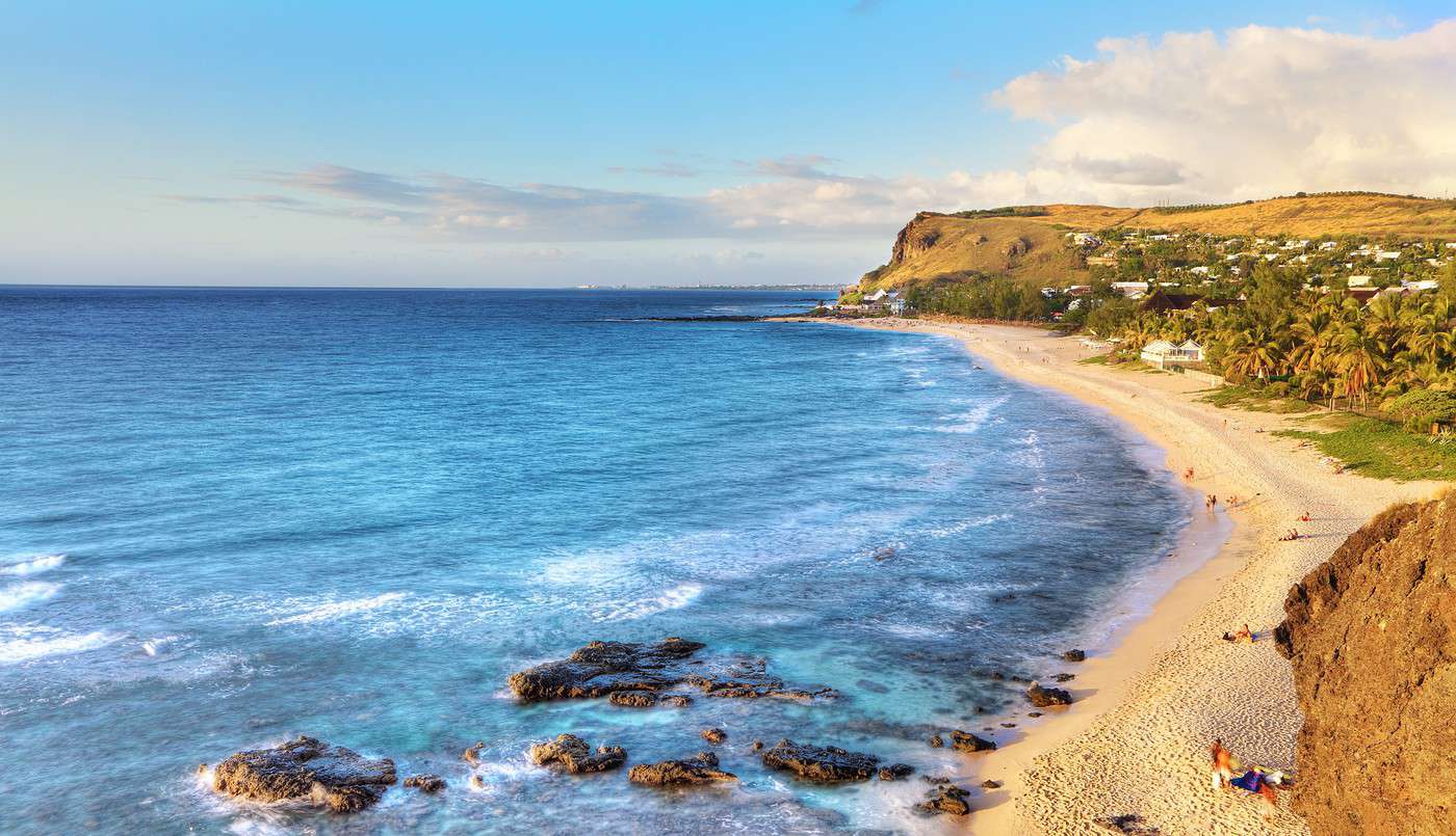
The "coastline" is the narrow coastal strip that encircles the island. This is where 80% of Reunion’s population lives and where the department’s major towns, including Saint-Denis, are located. A road following the sea loops around the island, offering a chance to discover its varied landscapes and the striking contrasts between the West Coast and the wilder East.

Overview

Boucan Canot, Réunion
Boucan Canot, Réunion · © VoyageForum

The "coastline" is the narrow coastal strip that encircles the island. This is where 80% of Reunion’s population lives and where the department’s major towns, including Saint-Denis, are located. A road following the sea loops around the island, offering a chance to discover its varied landscapes and the striking contrasts between the West Coast and the wilder East.

Main towns

Four-fifths of Reunion’s population lives along the coast. Logically, this is where all the island’s towns are found, including the largest ones: Saint-Denis, Saint-Paul, Saint-Louis and Saint-Pierre on the west coast, and Saint-André in the east.

Tourist attractions

Towns and their heritage

Reunion is primarily a "nature" destination, and its towns and villages hold relatively little architectural or historical heritage by comparison.

Beaches and seaside

Reunion is not Mauritius, and its beach and seaside resort scene is far less developed despite the nearly 500 km of coastline. The majority of swimming and water-based activities are concentrated along the west coast, stretching from Saint-Paul to Saint-Pierre. The rest of the coast is largely unsuitable due to its configuration and currents in certain areas.

Nature and activities

Reunion’s coastline is remarkably diverse. Beyond the beaches and resorts of the northwest, the south and east reveal wilder landscapes, even "ravaged" ones, as seen in the ancient lava fields flowing into the sea between Saint-Philippe and Sainte-Rose. Throughout, the island’s interior reliefs loom in the background, hinting at another side of Reunion. To fully appreciate these landscapes, the best way is still to drive around the island—200 kilometers that will easily fill a day.

Climate and weather

Boucan Canot

A well-frequented and pleasant beach resort officially located in the municipality of Saint-Paul.

Overview of Boucan Canot

A well-frequented and pleasant beach resort officially located in the municipality of Saint-Paul.

Key Details

  • Type de lieu: beach.
  • Intérêt touristique: (worth seeing).
  • Caractéristiques: white sand beach.
  • Localisation:
  • Longueur:

Environment

Precautions

What to See and Do

Climate and Weather

The area has a tropical climate that influences its temperature, sunshine, and rainfall, which remains one of the lowest on Réunion. The "dry season," from May to November, is the best time to visit.

Sea Temperature Throughout the Year

Jan.Feb.Mar.Apr.MayJun.Jul.Aug.Sep.Oct.Nov.Dec.
Boucan Canot262727262524232223232426

Practical Information

Getting There

Accommodation and Dining

Nearby Attractions

Additional Resources

View guide page: Boucan Canot

Bras Panon

A small town in the northeast of Réunion, about thirty kilometres from Saint-Denis.

Overview of Bras Panon

It's a small town in the northeast of Réunion, about thirty kilometres from Saint-Denis.

Key facts

  • Type of place: small town.
  • Tourist interest: (worth a stop if you are in the area).
  • Location:
  • Distances:
  • Local time: Heure : 2513.
  • Population: 12,735 inhabitants (2015).
  • Area: 88.55 km².
  • Altitude: sea level.

History of Bras Panon

What to see and do in Bras Panon

In the surrounding area

Climate and weather in Bras Panon

Transport

Getting there

Getting around

Accommodation

Food

Useful addresses

Further information

View guide page: Bras Panon

Étang Salé

A seaside locality with a black sand beach just before Saint-Louis when coming from the north. The town is home to a crocodile farm.

Overview of Étang Salé

It’s a seaside locality with a black sand beach just before Saint-Louis when coming from the north. The town is home to a crocodile farm.

Key details

  • Type de lieu: small town.
  • Intérêt touristique: (worth seeing).
  • Localisation:
  • Distances:
  • Heure locale: Heure : 2514.
  • Population: 14,330 inhabitants (2015).
  • Superficie: 38.65 km².
  • Altitude: from sea level to 1,781 m.

History of Étang Salé

What to see and do in Étang Salé

In the surrounding area

Climate and weather

Sea temperature throughout the year

Jan.Feb.Mar.Apr.MayJun.Jul.Aug.Sep.Oct.Nov.Dec.
Étang Salé262727262524232223232426

Getting around

How to get there

Getting around

Accommodation

Eating out

Useful addresses

Further information

View guide page: Étang Salé

L'Ermitage Beach

In the shade of the casuarina trees, this is the island's longest beach. Like Boucan and Saint-Gilles, it is part of the Saint-Paul municipality.

Overview of L'Ermitage Beach

In the shade of the casuarina trees, this is the island's longest beach. Like Boucan and Saint-Gilles, it is part of the Saint-Paul municipality.

Key Details

  • Type of place: beach.
  • Tourist interest: (worth seeing).
  • Features: white sand beach.
  • Location:
  • Length:

Environment

Precautions

What to See and Do

Climate and Weather

Sea Temperature Throughout the Year

Jan.Feb.Mar.Apr.MayJun.Jul.Aug.Sep.Oct.Nov.Dec.
L'Ermitage262727262524232223232426

Practical Information

Getting There

Accommodation and Dining

Nearby Attractions

  1. == Additional Information
View guide page: L'Ermitage Beach

Grande Anse

A very pretty little beach south of Saint-Pierre. It’s particularly busy on weekends.

Overview of Grande Anse

A very pretty little beach south of Saint-Pierre. It’s particularly busy on weekends.

Key Details

  • Type of place: beach.
  • Tourist interest: (worth seeing).
  • Features:
  • Location:
  • Length:

Surroundings

Precautions

What to see and do

Climate and weather in Grande Anse

Practical information

Getting there

Accommodation and dining

Nearby attractions

  1. == In addition
View guide page: Grande Anse

Sainte-Suzanne River

This small river in the northeast of Réunion is fed by beautiful waterfalls (including Niagara Falls). You can also go canyoning here.

Overview of the Sainte-Suzanne River

This small river in the northeast of Réunion is fed by beautiful waterfalls (including Niagara Falls). You can also go canyoning here.

Key details

  • Type of place: river.
  • Tourist interest: (worth seeing).
  • Features:
  • Length: 18.9 km.
  • Altitude:

Environment

What to see and do

Practical information

  • Location:

Getting there

Sleeping and eating

What to see nearby

  1. == In addition
View guide page: Sainte-Suzanne River

Lava Route

This section of the RN2, running from Saint-Philippe to Sainte-Rose in the south of the island, is one of the most beautiful on Réunion. Skirting the rugged coastline, it crosses the Grand Brûlé, a vast area where lava flows from the Piton de la Fournaise’s numerous eruptions have solidified.

Overview of the Lava Route

This section of the RN2, running from Saint-Philippe to Sainte-Rose in the south of the island, is one of the most beautiful on Réunion. Skirting the rugged coastline, it crosses the Grand Brûlé, a vast area where lava flows from the Piton de la Fournaise’s numerous eruptions have solidified.

Landmarks

  • Type of place: scenic route.
  • Tourist interest: (recommended).
  • Theme: scenic route.
  • Location:
  • Local time: Heure : 2530
  • Main towns:
  • Length: approximately 30 km.
  • Altitude: sea level.

The route

What to see and do

Itinerary

Nearby

Climate and weather

Transport

Getting there

Getting around

Accommodation

Food

  1. == Additional information
View guide page: Lava Route

Tamarins Scenic Route

This is the former coastal road linking Saint-Paul to L'Étang-Salé, now paralleled by a faster route. The original road runs along the coastline, offering some beautiful marine landscapes.

Overview of the Tamarins Route

This is the former coastal road linking Saint-Paul to Étang Salé, now paralleled by a faster route. The original road runs along the coastline, offering some beautiful marine landscapes.

Key Details

  • Type of place: scenic route.
  • Tourist interest: (worth a stop if you are in the area).
  • Theme: scenic route.
  • Location:
  • Local time: Heure : 2531
  • Main towns:
  • Length: 34 km.
  • Altitude:

The Route

What to See and Do

Itinerary

Nearby

Climate and Weather

Transportation

Getting There

Getting Around

Accommodation

Dining

  1. == Additional Information
View guide page: Tamarins Scenic Route

The Blowhole

A powerful spray of sea water shooting several metres high. This natural wonder is located on the coastline of the municipality of Saint-Leu.

Overview of the Blowhole

A powerful spray of sea water shooting several metres high. This natural wonder is located on the coastline of the municipality of Saint-Leu.

Key Details

  • Type of place: geyser.
  • Tourist interest: (worth a stop if you are in the area).
  • Features:
  • Location:
  • Altitude: sea level.
  • Maximum height:

Site Environment

Wildlife and Flora

What to See and Do

Nearby Attractions

Climate and Weather

Precautions

Getting There

Accommodation and Dining

  1. == Further Information
View guide page: The Blowhole

Coastal Road

This is the national road that circles the island along the coast. For visitors, it’s essentially a scenic route that reveals the island’s diverse landscapes and the striking contrasts between the developed west coast and the wilder east.

Overview of the Coastal Road

This is the national road (N1/N2) that circles the island along the sea. For visitors, it’s essentially a scenic route that reveals the island’s diverse landscapes and striking contrasts between the developed west coast and the wilder east coast.

Key Details

  • Type of place: scenic route.
  • Tourist interest: (recommended).
  • Theme: scenic route.
  • Location:
  • Local time: Heure : 2556
  • Main towns:
  • Length:
  • Altitude: sea level.
  • Website:

The Road

Sights and Activities

Itinerary

Nearby Attractions

Climate and Weather

Transport

Getting There

Getting Around

Accommodation

Food

  1. == Additional Information
View guide page: Coastal Road

Saint-André (974)

It's the largest city in the northeast of Réunion. It has Tamil temples and a small amusement park.

Overview of Saint-André

It's the largest city in the northeast of Réunion. It has Tamil temples and a small amusement park.

Key Facts

  • Type of place: city.
  • Tourist interest: (worth a stop if you are in the area).
  • Location:
  • Distances:
  • Local time: Heure : 10249.
  • Population: 55,730 inhabitants (2015).
  • Area: 53.07 km².
  • Altitude: from sea level to 1,084 m.

History of Saint-André

What to See and Do in Saint-André

In the Surrounding Area

Climate and Weather in Saint-André

Transportation

Getting There

Getting Around

Accommodation

Dining

Useful Addresses

Additional Information

View guide page: Saint-André (974)

Saint-Benoît (974)

It’s the last town on the east coast when coming from Saint-Denis.

Overview of Saint-Benoît

It’s the last town on the east coast when coming from Saint-Denis.

Key Facts

  • Type of place: small town.
  • Tourist interest: (worth a stop if you are in the area).
  • Location:
  • Distances:
  • Local time: Heure : 10250.
  • Population: 37,940 inhabitants (2015).
  • Area: 229.61 km²
  • Altitude: from sea level to 2,478 m.

History of Saint-Benoît

What to see and do in Saint-Benoît

In the surrounding area

Climate and weather in Saint-Benoît

Transport

Getting there

Getting around

Accommodation

Eating

Useful addresses

Further information

View guide page: Saint-Benoît (974)

Saint-Denis (974)

The prefecture of Réunion has only a few old buildings and two museums. For tourism, the city mainly serves as the arrival point on the island. Introduction to Saint-Denis Climate and Weather in Saint-Denis What to See in Saint-Denis Things to Do in Saint-Denis Flying to Saint-Denis Getting to Saint-Denis by Land or Sea Getting Around in Saint-Denis Sleeping and Eating in Saint-Denis Living in Saint-Denis

Further information

View guide page: Saint-Denis (974)

Introduction to Saint-Denis

Overview of Saint-Denis

The capital of Réunion has just a few historic buildings and two museums. For tourism, the city mainly serves as the arrival point on the island.

Key Facts

  • Type of place: large city.
  • Tourist interest: (worth a stop if you are in the area).
  • Location:
  • Distances:
  • Local time: Heure : 10251.
  • Population: 146,985 inhabitants (2015).
  • Area: 142.79 km².
  • Altitude: from sea level to 2,276 m.

History of Saint-Denis

Precautions

Useful Addresses

  • Tourist Office:

Services

  • Local agencies:
  • Banks:
  • Hospital:
  • Internet:
  • Laundries:
  • Vehicle rental:
  • Post office:
View guide page: Introduction to Saint-Denis

Climate and Weather in Saint-Denis

Climate Overview

The city has a humid tropical climate that influences its temperature, sunshine, and rainfall. While temperatures are fairly pleasant year-round, it’s the precipitation that defines the best times to visit. The "dry season," from May to November, is the most favorable.

Best Climate Period for Saint-Denis

Jan.Feb.Mar.Apr.MayJun.Jul.Aug.Sep.Oct.Nov.Dec.
Saint-Denis /

: very favorable | : favorable | : moderately favorable | : unfavorable.

Sea Temperature Throughout the Year

Jan.Feb.Mar.Apr.MayJun.Jul.Aug.Sep.Oct.Nov.Dec.
Réunion262727262524232223232426

Climate and Forecast

Additional Information

View guide page: Climate and Weather in Saint-Denis

What to See in Saint-Denis

Léon Dierx Museum ★ The venue houses a collection of modern and contemporary paintings, including works by Réunionese artists. Réunion Natural History Museum ★ Housed in a nearly two-century-old building in the Jardin de l'État, this museum showcases the…

Read the full guide: What to See in Saint-Denis

Flying to Saint-Denis

Airport in Saint-Denis

Airport details

  • Name: Réunion-Roland Garros Airport (sometimes also called Gillot).
  • IATA code: RUN
  • Hub:
  • Number of terminals: 1.
  • Annual passenger capacity:
  • Passenger traffic: 2,293,042 (2017).
  • Distance from city centre: 7 km east of the city.

Services

Sleeping at the airport

Transport to the city centre

Other nearby airports

From mainland France and Europe

From Africa and the Indian Ocean

From Asia

Additional information

View guide page: Flying to Saint-Denis

Saint-Gilles (974)

Located on the northwest coast and officially part of the Saint-Paul municipality, it is the main seaside resort of Réunion, with its share of (large) hotels and its marina. You can surf or go diving here. Saint-Gilles is also home to the Réunion aquarium and a lovely landscaped garden ("Eden Garden").

Overview of Saint-Gilles

Located on the northwest coast and officially part of the Saint-Paul municipality, it is the main seaside resort of Réunion with its share of (large) hotels and its marina. You can surf or go diving here. Saint-Gilles (officially Saint-Gilles-les-Bains) is also home to the Réunion aquarium and a lovely landscaped garden ("Eden Garden").

Key Details

  • Type de lieu: small town.
  • Intérêt touristique: (worth seeing).
  • Localisation:
  • Distances:
  • Heure locale: Heure : 10252.
  • Population:
  • Superficie:
  • Altitude: sea level.

History of Saint-Gilles

What to See and Do in Saint-Gilles

In the Area

Climate and Weather

The locality, considered one of the hottest on the island, has a tropical climate that influences its temperature, sunshine, and rainfall, which remains among the lowest on Réunion. The "dry season", from May to November, is the best time to visit.

Sea Temperature Throughout the Year

Jan.Feb.Mar.Apr.MayJun.Jul.Aug.Sep.Oct.Nov.Dec.
Saint-Gilles262727262524232223232426

Transport

Getting There

Getting Around

Accommodation

Food

Useful Addresses

Further Information

View guide page: Saint-Gilles (974)

Saint-Joseph (974)

This is the southernmost municipality in the department. On its outskirts, you’ll find several beaches, including Manapany, a favorite among surfers, as well as the beautiful Langevin River with its small waterfalls.

Overview of Saint-Joseph

This is the southernmost municipality in the department. On its outskirts, you’ll find several beaches, including Manapany, a favorite among surfers, as well as the beautiful Langevin River with its small waterfalls.

Key Details

  • Type of place: small town.
  • Tourist interest: (worth a stop if you are in the area).
  • Location:
  • Distances:
  • Local time: Heure : 10253.
  • Population: 37,608 inhabitants (2015).
  • Area: 178.50 km².
  • Altitude: from sea level to 2,448 m.

History of Saint-Joseph

What to See and Do in Saint-Joseph

In the Surrounding Area

Climate and Weather in Saint-Joseph

Transportation

Getting There

Getting Around

Accommodation

Dining

Useful Addresses

Additional Information

View guide page: Saint-Joseph (974)

Saint-Leu (974)

A seaside resort between Saint-Pierre and Saint-Denis with great surfing, diving, and paragliding spots. In the town, you can visit several museums (salt museum, Stella Matutina sugar cane museum, Mascarin botanical conservatory) as well as a sea turtle observation centre ("Kelonia").

Overview of Saint-Leu

It's a seaside resort between Saint-Pierre and Saint-Denis with a great surfing spot, diving, and, in a different vein, paragliding. In the town, you can visit several museums (salt museum, Stella Matutina sugar cane museum, Mascarin botanical conservatory) as well as a sea turtle observation centre ("Kelonia").

Key Facts

  • Type of place: small town.
  • Tourist interest: (worth seeing).
  • Location:
  • Distances:
  • Local time: Heure : 10254.
  • Population: 33,701 inhabitants (2015).
  • Area: 118.37 km².
  • Altitude: from sea level to 2,782 m.

History of Saint-Leu

What to See and Do in Saint-Leu

In the Surrounding Area

Climate and Weather in Saint-Leu

Sea Temperature Throughout the Year

Jan.Feb.Mar.Apr.MayJun.Jul.Aug.Sep.Oct.Nov.Dec.
Saint-Leu262727262524232223232426

Transport

Getting There

Getting Around

Accommodation

Food

Useful Addresses

Further Information

View guide page: Saint-Leu (974)

Saint-Louis (974)

One of Réunion’s "major towns" with over 50,000 inhabitants, though not necessarily one of the most tourist-focused.

Overview of Saint-Louis

It's one of the "major towns" of Réunion with over 50,000 inhabitants, though not necessarily one of the most tourist-focused.

Key facts

  • Type of place: city.
  • Tourist interest: (worth a stop if you are in the area).
  • Location:
  • Distances:
  • Local time: Heure : 10255.
  • Population: 53,524 inhabitants (2015).
  • Area: 98.90 km².
  • Altitude: from sea level to 2,543 m.

History of Saint-Louis

What to see and do in Saint-Louis

In the surrounding area

Climate and weather in Saint-Louis

Sea temperature throughout the year

Jan.Feb.Mar.Apr.MayJun.Jul.Aug.Sep.Oct.Nov.Dec.
Saint-Louis262727262524232223232426

Transport

Getting there

Getting around

Accommodation

Food

Useful addresses

Further information

View guide page: Saint-Louis (974)

Saint-Paul (974)

This large municipality is best known for its "localities"; including Saint-Gilles, Boucan Canot beaches, and Maïdo Peak. In Saint-Paul itself, however, you can visit the Marine Cemetery, where many pirates are buried, and the Cave of the First French.

Overview of Saint-Paul

This large municipality is best known for its "localities"; including Saint-Gilles, the beaches of Boucan Canot, and the Maïdo Peak. In Saint-Paul itself, however, you can visit the Marine Cemetery, where many pirates are buried, and the Cave of the First French.

Key Facts

  • Type of place: city.
  • Tourist interest: (worth seeing).
  • Location:
  • Distances:
  • Local time: Heure : 10256.
  • Population: 105,967 inhabitants (2015).
  • Area: 241.28 km².
  • Altitude: sea level to 2,955 m.

History of Saint-Paul

What to See and Do in Saint-Paul

In the Surrounding Area

Climate and Weather in Saint-Paul

The town, considered one of the hottest on the island, has a tropical climate that influences its temperature, sunshine, and rainfall, which remains among the lowest on Réunion. The "dry season", from May to November, is the best time to visit.

Sea Temperature Throughout the Year

Jan.Feb.Mar.Apr.MayJun.Jul.Aug.Sep.Oct.Nov.Dec.
Saint-Paul262727262524232223232426

Transportation

Getting There

Getting Around

Accommodation

Dining

Useful Addresses

Further Information

View guide page: Saint-Paul (974)

Saint-Philippe (974)

This large village in the south of Réunion marks the start of the stunning Lava Route. Here you can visit the garden of perfumes and spices.

Overview of Saint-Philippe

This large village in the south of Réunion marks the start of the stunning Lava Route. Here you can visit the garden of perfumes and spices.

Key facts

  • Type of place: small town.
  • Tourist interest: (worth a stop if you are in the area).
  • Location:
  • Distances:
  • Local time: Heure : 10257.
  • Population: 5,115 inhabitants (2015).
  • Area: 153.94 km²
  • Altitude: from sea level to 2,630 m.

History of Saint-Philippe

What to see and do in Saint-Philippe

In the surrounding area

Climate and weather

Transport

Getting there

Getting around

Accommodation

Eating

Useful addresses

  1. == Further information
View guide page: Saint-Philippe (974)

Saint-Pierre (974)

It is the third-largest urban area in Réunion. A lively seaside resort with its waterfront and marina. It is the third-largest urban area in Réunion . A lively seaside resort with its waterfront and marina. Type of place: city. Tourist interest : ★★ (worth…

Read the full guide: Saint-Pierre (974)

Sainte-Marie (974)

East of Saint-Denis, the town is home to Roland Garros Airport and houses several religious sites (Black Virgin, Jesuit cemetery, etc.).

Overview of Sainte-Marie

East of Saint-Denis, the town is home to Roland Garros Airport and houses several religious sites (Black Virgin, Jesuit cemetery, etc.).

Key Facts

  • Type of place: small town.
  • Tourist interest: (worth a stop if you are in the area).
  • Location:
  • Distances:
  • Population: 32,940 inhabitants (2015).
  • Area: 87.21 km².
  • Altitude: from sea level to 1,800 m.

History of Sainte-Marie

What to See and Do in Sainte-Marie

In the Surrounding Area

Climate and Weather in Sainte-Marie

Transportation

Getting There

Getting Around

Accommodation

Dining

Useful Addresses

  1. == Additional Information
View guide page: Sainte-Marie (974)

Sainte-Rose (974)

A locality in the southeast of Réunion, at the end of the Lava Road. The village is famous for its church, Notre Dame des Laves, encircled by a lava flow (now solidified) in 1977.

Overview of Sainte-Rose

A locality in the southeast of Réunion, at the end of the Lava Route. The village is known for its church, Notre Dame des Laves, encircled by a lava flow (now solidified) in 1977.

Key details

  • Type of place: small town.
  • Tourist interest: (worth seeing).
  • Location:
  • Distances:
  • Local time: Heure : 10260.
  • Population: 6,621 inhabitants (2015).
  • Area: 177.6 km².
  • Altitude: from sea level to 2,623 m.

History of Sainte-Rose

What to see and do in Sainte-Rose

In the surrounding area

Climate and weather in Sainte-Rose

Transport

Getting there

Getting around

Accommodation

Food

Useful addresses

Further information

View guide page: Sainte-Rose (974)

Langevin River

In the south of the island, a small road follows the river to the Grand-Galet waterfall. You can hike in the surrounding area.

Overview of the Langevin River

In the south of the island, a small road follows the river to the Grand-Galet waterfall. You can hike in the surrounding area.

Key details

  • Type of place: river.
  • Tourist interest: (worth a stop if you are in the area).
  • Features:
  • Length: 18.3 km.
  • Altitude:

Environment

What to see and do

Practical information

  • Location:

Getting there

Sleeping and eating

What to see nearby

  1. == En complément
View guide page: Langevin River

Anse des Cascades

The sea, a small landing stage for fishermen's boats, an expanse planted with palm trees, and waterfalls cascading down the surrounding basalt cliffs.

Overview of Anse des Cascades

The sea, a small landing stage for fishermen's boats, an expanse planted with palm trees, and waterfalls cascading down the surrounding basalt cliffs.

Key Details

  • Type of place: waterfall.
  • Tourist interest: (worth seeing).
  • Features:
  • Height:
  • Altitude: sea level.

Site Environment

Climate and Weather

Precautions

What to See and Do

Practical Information

  • Location:
  • Distances:

Getting There

Accommodation and Dining

Nearby Attractions

  1. == En complément
View guide page: Anse des Cascades

Something wrong or out of date? Report this page