A summer in the sun in... Iceland!!

Translated into English.

Original post
MA
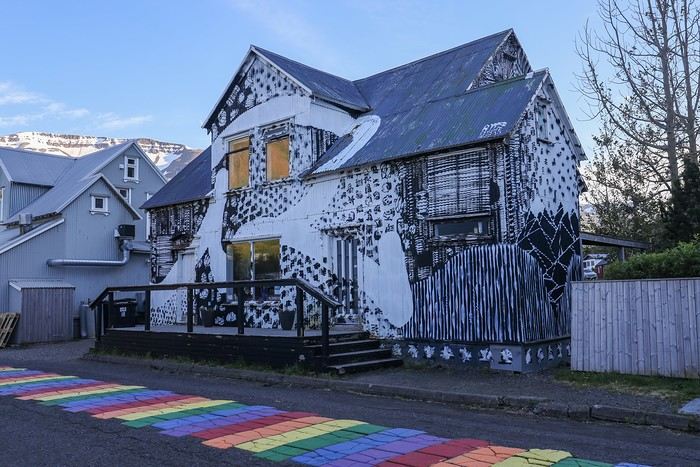
Ah, Iceland and us—it’s quite the story, or rather, a long wait... The first time we considered going was already 7-8 years ago, after reading travel journals describing breathtaking landscapes, countless active and dormant volcanoes, glaciers, and waterfalls with extraordinary flows. In short, this island, made of fire and ice, right at Europe’s doorstep with its own unique culture, had nothing but advantages, and it was urgent to visit without delay

My *Routard* guidebook is actually from 2016. So why did Iceland make us wait so long before we finally gave in to its charms? Yes, why indeed?

Simply because reading other travel journals revealed the cost of living there—and especially the harsh climate, even in the middle of July ! Some journals described entire weeks of rain and foggy weather, making it tricky to explore the island. The budget wasn’t spared either, because in the most touristy areas, especially in the south and around Myvatn, accommodation prices are downright indecent—even outright robbery. [:/]

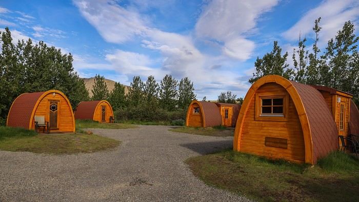
Plus, in the Highlands, there’s literally no permanent lodging, and the only way to spend several nights there is to camp. And camping in winter conditions wasn’t exactly part of our plans...

So, year after year, this trip kept getting postponed...

until August 2023, when prices for Southern Africa, North or South America, or even Asia were all way too high for summer 2024!

That’s when I turned my attention back to the Land of Fire and Ice and scoured all the comparison sites for the best accommodation deals across the country. Planning for 20 nights, I found 13 nights in "proper" lodging for 5 people at an average cost of under 200 €! A miracle, considering that in the southern glacier region, around Vik or Myvatn, prices range from 300 to 1000 € per night !

Still, that means we’ll have to camp for 7 nights, mostly in the Highlands, near Askja or Landmannalaugar.

For once, I built the daily itinerary entirely around the decently priced lodgings I found 11 months in advance! The shortage of places to stay in some areas forced me to plan a few long transition days and make some tough choices. No big deal, though—there’s so much to do on this island [:)]!

Once the main itinerary was set, everyone agreed to the plan: 2/3 in proper lodging and 1/3 camping, even the most camping-averse among us! *Follow my gaze...*

By the time we bought the flight tickets, I had to tweak the itinerary a bit because one or two places were already booked! Plus, it was impossible to wait for a more refined plan to adjust reservations, since almost all bookings are non-refundable!! The harsh law of supply and demand...

For the car rental, we booked a Hyundai Tucson, approved for the Highlands, from Lava Car Rental—a company I’d read good reviews about in a Facebook group—for a cool 2500 € with full insurance. A real 4x4, like a Defender, would’ve been more than double...! Welcome to Iceland [:/]...

Activities and excursions also required some tough choices. We had two must-dos: whale watching in Húsavík (60 € pp on Getyourguide) and a Glacier and Summer Treasure Glacier Walk with BlueIceland (165 € pp with discount codes on Getyourguide).

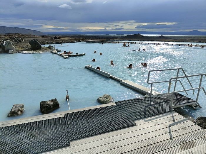
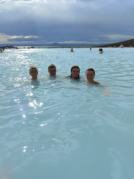
For the baths, we skipped the Blue Lagoon—too expensive—in favor of the Secret Lagoon and the Myvatn Baths, the Blue Lagoon’s equivalent but half the price.

Two baths for the price of one... and even more, since I spotted several free hot-water swimming spots.

Itinerary: 
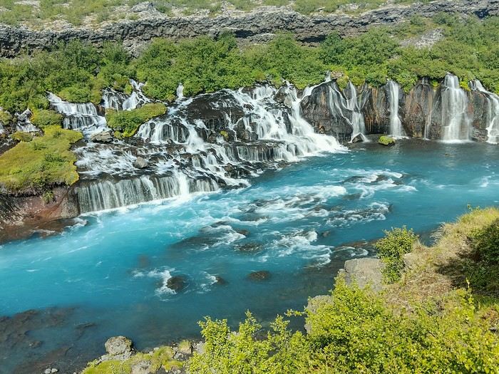
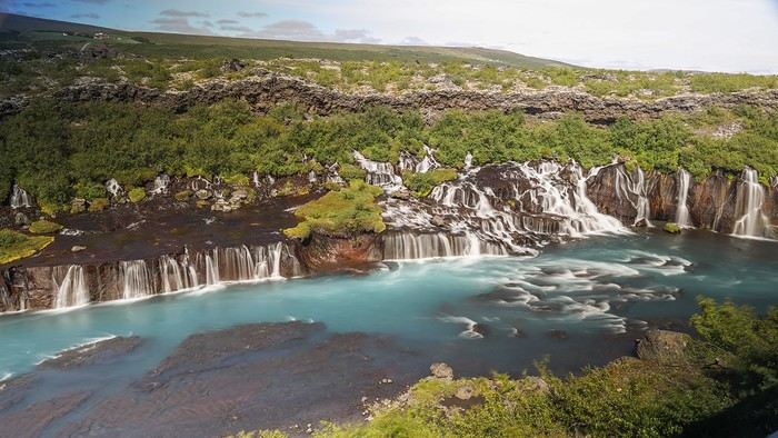
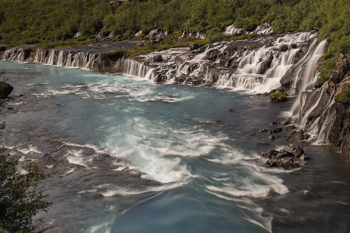
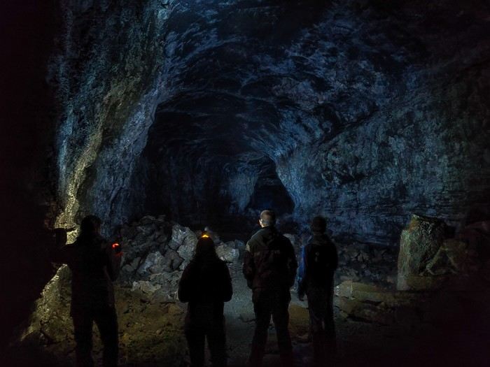
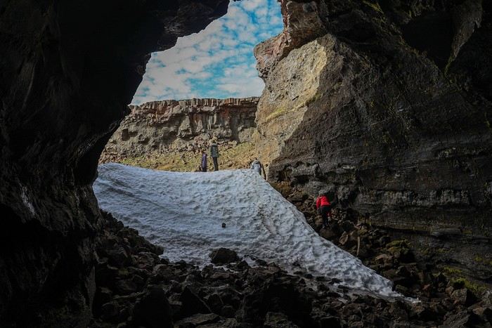
Day 1: Arrival in Reykjavik - Hraunfossar Waterfall - Surtshellir Cave 
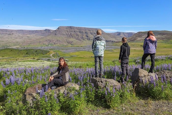
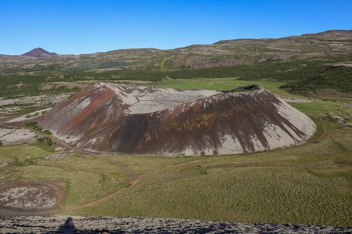
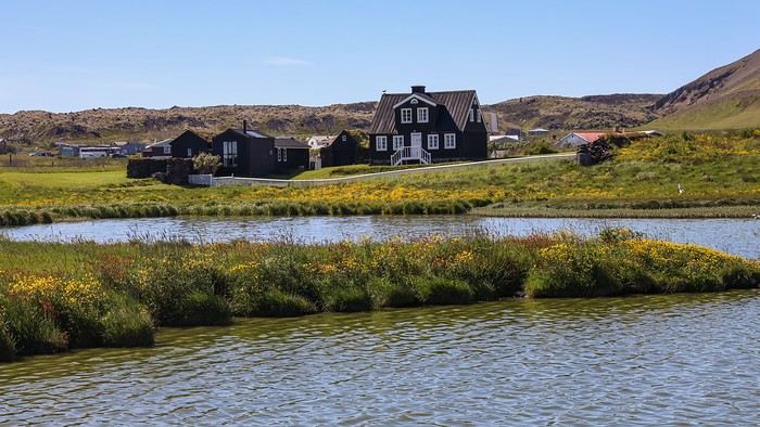
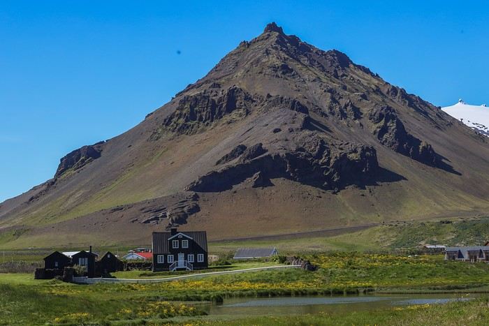
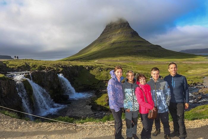
Day 2: Grábrók Crater - Snæfellsnes Peninsula 
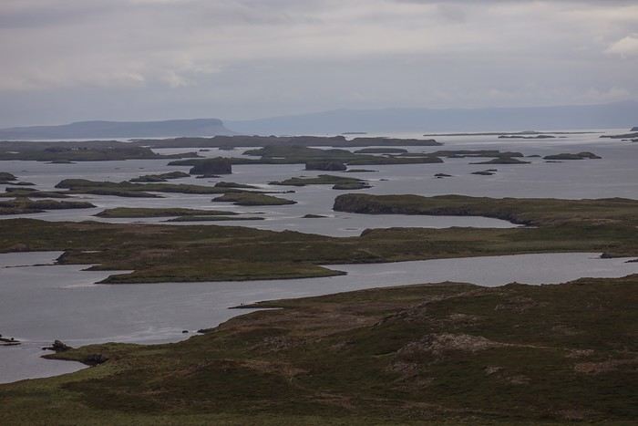
Day 3: Stykkishólmur - Sturlungalaug Hot Springs 
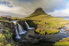
Day 4: Northwest Coast - Akureyri - Goðafoss
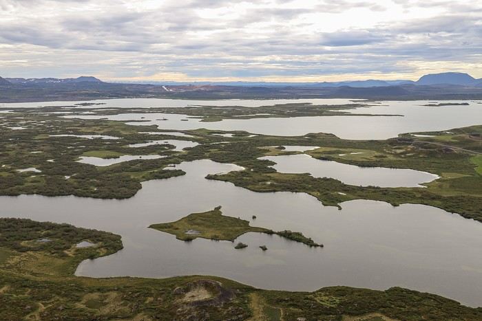
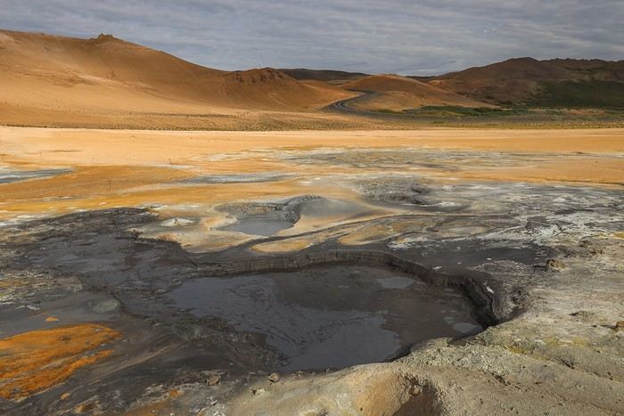
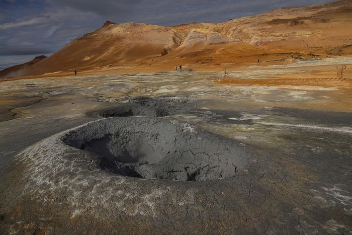
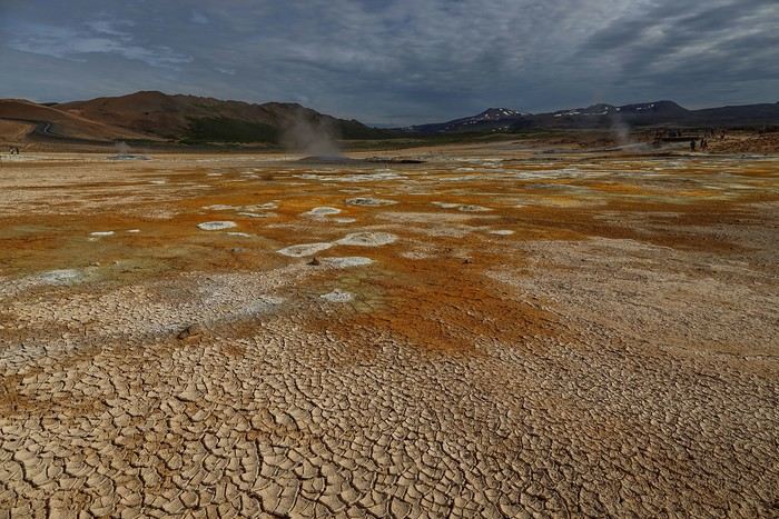
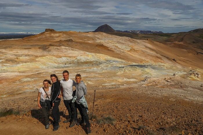
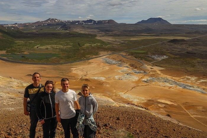
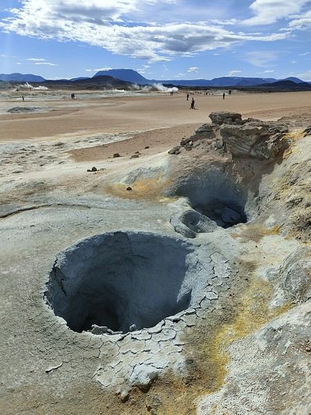
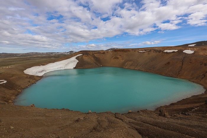
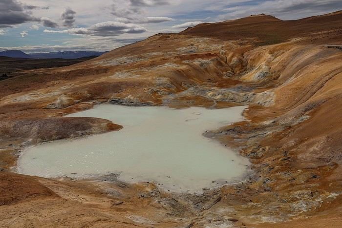
 Day 5: Myvatn 
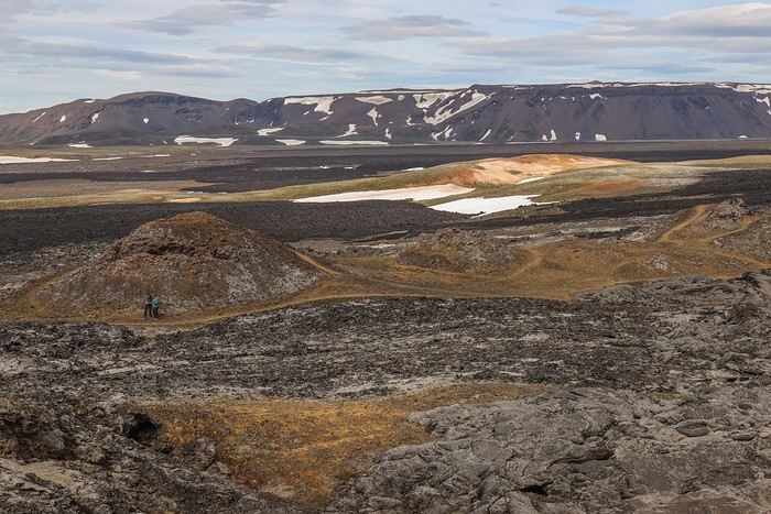
Day 6: Myvatn - Dettifoss - Selfoss - Rauðhólar Day 7: Húsavík Whale Watching - Dettifoss - Selfoss Day 8: Stuðlagil Canyon - Seyðisfjörður Day 9: Puffin colony - Störurð Hike Day 10: Hengifoss - East Fjords, Mjóifjörður Day 11: Viking Village - Jökulsárlón - Fjallsárlón Day 12: Glacier Excursion - Svartifoss Day 13: Fjaðrárgljúfur Canyon - Vík Day 14: Þakgil - Lava Show Vík Day 15: Southern Waterfalls Day Day 16: Landmannalaugar - Skalli Hike Day 17: Landmannalaugar - Bláhnjúkur - Brennisteinsalda Day 18: Secret Lagoon, Kerlingarfjöll, and Gullfoss Day 19: Geysir - Reykjavik 
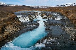
Day 20: Bruarfoss - Þingvellir - Kerid Crater - Krýsuvík Geothermal Area Day 21: Reykjanes Peninsula

Friday, July 5, 2024, is our last workday before driving up to Alsace overnight to leave the cockers at Grandpa’s for boarding. Then, at 1:30 AM, we’ll head to Frankfurt, where a direct flight to Iceland awaits.

We arrive at 4 AM. Since we leave at 7 AM, the "night" will only last the equivalent of a 30-minute nap ... just enough to get us in the road-trip mood !!
MA
Day 1 - 07/06: Arrival in Reykjavik - Hraunfossar Waterfall - Surtshellir Cave The Icelandair flight from Frankfurt to Keflavik only took 2.5 hours—quite a change from our usual long-haul flights. During the flight, we got the bare minimum service: a bottle of water and that’s it. No screens, no snacks, no other drinks.

As soon as we step out of the terminal, we’re greeted by bright sunshine but a very cold wind. We quickly realize our ski jackets won’t be leaving our sides often!

After a quick call and a 10-minute wait, a Lava Car shuttle picks us up to drop us off at their office. The employee is friendly, and we get the keys quickly. No insurance is pushed on us—and for good reason, we already took care of all that to be on the safe side!

It actually takes us longer to find the Tucson, and we have to play Tetris to fit all our luggage—even though we only packed one big clothes suitcase for five of us!

The rest of the luggage is for camping gear (tent, sleeping pads, sleeping bags), a second pair of shoes, food, etc.

So focused on optimizing luggage space, we didn’t even think to check where the spare tire and jack were—something we *always* do in the U.S.


After a quick grocery run at a Netto in the Reykjavik suburbs, we head into the countryside and meet the lupines in full bloom across vast fields.


We head toward Akranes because I’d spotted the Guðlaug baths at a good price. But when we arrive, we understand why...

The baths look more like a crowded concrete pool by the beach. The setting is far from the idyllic scenes some photos online suggest.

There isn’t even a proper changing room—it seems people come already wearing their swimsuits!

We decide to skip it and continue along Route 1 until we find a nice spot for a picnic. The view is stunning, but the wind is *brutal*—and freezing!

After lunch, we set off to explore Hraunfossar, one of Iceland’s most beautiful waterfalls! Unlike the country’s more famous falls, Hraunfossar—or "lava waterfalls"—gets its name from a series of streams and cascades flowing over lava rock lined with lichen.

What makes it special isn’t its height or water volume, but the fact that countless streams spill over nearly a kilometer into turquoise-blue water!


A well-maintained trail lets you see it from different angles.


A little farther away, Barnarfoss—or "children’s waterfall"—is said to be named after an accident where two farm children fell from the natural stone bridge above the water.

This waterfall is pretty ordinary compared to its neighbor (not worth one of the 300 photos we took).

A bit more driving to reach the end of Route 578, and we park in a huge, empty lot—the starting point for the Surtshellir cave. Why this cave? Because it’s one of the few you can visit without a guide *and* it’s free! Elsewhere, you’d pay 50 € per person just to walk through a lava tunnel. We thought that was way too expensive for what it is...

We each grab our headlamps and quickly dive into the cave to explore.

The temperature inside is cool and damp, as expected.

The walk is fun, with alternating flat sections and big rocks. Some of the lava stones have a really unique texture.

The cave must be about 500–600 meters long, and we all love the feeling of being completely alone, navigating only by our headlamps!


At the other end, we find a huge pile of snow we have to go around to reach a stone mound that’s supposed to help us exit... Except there’s a 2-meter climb up the cave wall above the pile of rocks !!


One wrong move, and we’re looking at serious scrapes—or worse.

No way we’re taking that risk, especially with my knee still recovering from ACL surgery just three months ago. So we turn back.

Too bad, because right near that exit, there’s supposed to be a way to connect to another cave, Stefanshellir, according to maps.me.

Time’s getting on—it’s nearly 6 PM—so no more dawdling on the way back. Well, *they* move quickly; my knee’s acting up, and I’m limping despite my brace...

Back in the open air, we’re almost at the parking lot. Even though the sun’s still high, it’s too late to try Stefanshellir by the surface route. We’ll have to get used to planning our days by the clock, not the sun—since it barely sets at these latitudes this time of year.

Before heading to Fossatun, where we’ve booked a cabin, we stop at the Stalrid Food Truck, right next to a geothermal site, Deildartunguhver.

The menu? A choice between a *normal* Fish & Chips and a... *small* Fish & Chips.

After 20 minutes of deliberation, everyone goes for... Fish & Chips, which you can eat in a greenhouse where mostly tomatoes are grown.


Some of us like the meal, others find it too greasy!

We’ll have to get used to this kind of food—it seems Icelanders aren’t big on refined cuisine, at least not in our budget range...

Because let’s be real: 120 € for five boxes of Fish & Chips and five sodas *hurts* a little !

The worst part? I scoured Google to find all the restaurants, diners, and food trucks with "reasonable" prices along our route.

Just before arriving at Fossatun:


For our first night, I booked two cabins at a great price (2 x 86 €) at Fossatun Camping Pods & Cottages.


At this unusually low price for Iceland, bed linens aren’t provided, so we use our sleeping bags.

The shared bathrooms are right next to the two hot tubs, where we rush to soak after a mandatory shower as soon as one frees up. The water quality is a bit questionable, so we all prefer to shower again afterward.

Drying our stuff is easy—it’s nearly 30°C inside the (over)heated cabins thanks to geothermal energy ! This’ll be a constant in all our lodgings, and we’ll often have to open the windows because there’s no way to adjust the heating !
AT
I layered on 3 fleeces, a raincoat, fur-lined boots, a pair of gloves, and a beanie. Ready for the rest of the trip! [;)]

I loved the Surtshellir area even though descending into the lava tunnels wasn’t possible (too much snow). After that, it was pretty much the only place I saw the sun in Iceland...
Un si beau paysage : concours de photos amical de juin 2026 Rubrique Jeux Voyages C'est le moment de poster vos meilleurs clichés !
MA
It was after reading your travel journal that everyone got cold feet about going to Iceland, even in summer !!

You can put away your winter gear—we’ll be in T-shirts, or nearly, for two-thirds of the trip !
AT
Ugh! 😇 It's true I really didn't have any luck! 🏴‍☠️ A couple I met at the start of my trip had 3 weeks of almost non-stop sunshine. 😡
Un si beau paysage : concours de photos amical de juin 2026 Rubrique Jeux Voyages C'est le moment de poster vos meilleurs clichés !
MA
Day 2 - 07/07: Grábrók Crater - Snæfellsnes Peninsula

A quick check on the Vedur app gives us bad weather forecasts for tomorrow. So, we decide to cancel the R50 "Baejarfell" hike from the Rother guide and postpone tomorrow’s dip in the Landbrotalaug hot springs. This way, we’ll have the whole day to explore the Snæfellsnes Peninsula.

This peninsula, often called "Iceland in miniature," is famous for offering a concentration of all the natural wonders Iceland has to offer: waterfalls, beaches, cliffs, canyons, caves, volcanoes, glaciers, and seal colonies.

In short, if the guides live up to their promises, we might just experience one of the best days of our trip! So, it’s best to have the weather on our side...

Since we’ll be driving a lot in sometimes remote areas, I prefer to fill up the gas tank. The little detour takes us through a field of lupins stretching as far as the eye can see and past the Reykholt church, which has an unusual architecture.


The first highlight of the day is the Grábrók crater. It’s a 3,000-year-old volcano that’s easy to climb, with only 170 meters of elevation gain, thanks to well-maintained walkways and stairs.

Sure, the site lacks a bit of authenticity, but at least it helps contain the wanderings of bipeds and protects the natural flora.

From the top of the crater, the view of the lava fields covered in moss is stunning,


as is the view of Grábrókarfell, the other imposing crater right next to it, also covered in moss! What a striking contrast!

The inside of the Grábrók crater is a bit marred by the walkway, so we’re not too impressed.


At the southern entrance of the Snæfellsnes Peninsula, I’d spotted an unusual site, Gerðuberg. It’s a wall of large hexagonal basalt columns stretching over a kilometer long.


A few clouds give us some nice contrasts on the mountains lining the road.

The peninsula is home to a seal colony on Ytri Tunga beach. When we see the number of cars parked in the paid parking lot, we think we made the right call stopping... but as we get closer to the end of the beach, we don’t see any seals...

Following other people to the tip, jumping from rock to rock, we finally spot about ten seals.


There really aren’t many! At least, not on the seal side—because on the human side, it’s a different story!

After a few satisfying shots, we don’t linger.

Our next stop, about twenty kilometers further west, is the Bjarnafoss waterfall.


Right next to it is the village of Búðir, which is worth the detour for its beautiful black church nestled in an idyllic setting!

MA
As we leave the village, we come across a few sheep with really thick fleece. You need it to handle the Icelandic climate!


It’s almost lunchtime when we reach the Rauðfeldsgjá gorges. As soon as we get out of the car, there’s a terrible wind that doesn’t let up as we approach the canyon.


From a distance, we see people staying by the edge of a mini-waterfall coming from deep within the earth. Instead of walking the last 300 meters to the canyon’s edge, we suddenly feel lazy and prefer to settle for the overall view of the cliff.

On the way back, I realize we could’ve walked inside the gorges, through the slot canyon. A bit annoyed afterward at our laziness, even though the river’s flow might not have let us go very far...

So, around 1 PM, we arrive in Arnarstapi for lunch—not at that cute little restaurant (way over budget)


but at a street food truck serving excellent quesadillas!

Before taking a walk along the Arnarstapi coast, we backtrack to take Route 570 leading to the Snaefellsjokull glacier. But the road is in bad shape, and we struggle just to reach the Sönghellir cave.

Actually, there are even two caves, and they make for some cool photos!


Back in Arnarstapi, we leave our car near the harbor to start the seaside walk.

The setting is idyllic, the cove gorgeous—though we can’t imagine swimming here...


One house in particular catches our eye...


Birds have made their home in the hollows of some cliffs. Clearly, they don’t bother flying away to do their business...


The walk leads us to this viewpoint, offering a glimpse of the entire coast. We see a few more people gathered at the other parking lot, but no matter—the view from there is probably about the same.

Since my knee is acting up again, I figure it’s not worth the detour just to change the angle...

Oh no...! It’s only on the way back, when I look up Arnarstapi on Google, that I find out we missed the circular rock arch of Gatklettur that was right there !

Oh well.
MA
The next viewpoint is Londrangar, two massive rocky pinnacles standing by the sea. One rises to 75 m and the second to 61 m! With wind strong enough to blow the horns off a bull, I try to keep my DSLR steady to capture the scene.


We then reach the western tip of the peninsula.

There would have been the option to take a guided tour of the Vatnshellir cave, but since we’d already visited one, we skip it and head to Djúpalón’s black sand beach instead.

The small loop trail takes us through a lava field, complete with a bonus arch!


After a stop at the Saxholl crater—which, luckily, was on our route but wasn’t a must-see—

we make another beach stop at Skarðsvík Beach. This time, the sand is a mix of all colors, with a yellowish hue dominating.


The weather takes a turn for the worse by the end of the day, and it’s forecasted that clouds will cover the sky until tomorrow evening.

Then, suddenly, just a few minutes from Grundarfjörður, a break in the clouds appears—one that might not last long.


As it happens, we arrive just in time at Kirkjufellsfoss, one of Iceland’s most photographed sites.

We hurry to find a parking spot—paid, as is so often the case in Iceland—to snap our own souvenir photo.


That’s when we realize how lucky we are to catch this little window of opportunity. Looking back, I think the two hiccups of the day—which ended up saving us a good hour in our schedule—turned out to be a blessing in disguise...

For a packed day, it was *very* packed... but absolutely stunning , with one incredible site after another, and a grand finale at Kirkjufellsfoss . Half a day extra wouldn’t have been too much to explore the whole peninsula, but we’ll take what the weather gives us!

We spend the night at Grundarfjordur Stöð Guesthouse (168 €), a guesthouse with rooms that can accommodate 2 to 6 people. It’s clean and welcoming. Like in other guesthouses or motels to come, there’s a space at the entrance to leave your shoes, and everyone walks around in socks—or even barefoot.
GI
Oh, Iceland, what a magnificent country!

I threw on my merino clothes to follow your adventure! 😄
Nathalie

Photos et carnets de voyage : http://www.girardinphoto.net
MU
Hello Guillaume

Iceland is gorgeous under the sun (even a single ray of sunshine [;)]). I’d been tempted by the landscapes for years, but always ended up choosing warmer destinations instead . I knew prices were high... but I didn’t realize they were *that* bad I’m still heading there though, after layering up some extra clothes (even with the sun, your sheep look pretty windswept ).
Si tu diffères de moi, mon frère, loin de me léser, tu m'enrichis (Saint Exupéry)
MA
Hi Nathalie and Muriel, there’s plenty of room to hop in!

Muriel, you’re absolutely right about the wind—it’s often up there at the top of the hills... where I took the sheep photos !!

Weather-wise, I think we picked the right year—this summer, people seemed pretty fed up with all the rainy days in a row !
MA
Day 3 - 08/07: Around Stykkisholmur - Sturlungalaug Hotsprings

After a restful night without having to wake up at dawn, we enjoy a leisurely breakfast at the guesthouse.

A quick drive to Grundarfjördur, where nothing tempts us to get out of the car...

So we try our luck again in Stykkisholmur, supposedly the most beautiful town in Snaefellsnes.

Not much to see here either—we suspect the *Routard* writer might be a bit biased!

Leaving Stykkisholmur, we stop for a walk that’s popular with locals: the climb to the top of Helgafell. When we arrive, we suspect the land is private—there’s a parking lot and a small booth in the middle of nowhere, ready to take a few Icelandic krona from us!

The climb is quick, offering a panoramic view of the surroundings.

Now, time for a hot-water soak—one of Iceland’s treasures!

I’d planned to swim at Landbrotalaug Hotsprings, but the only "hole" big enough barely fits two people. A couple had just gotten in, so we weren’t about to wait our turn. A little further on, we find another spot, but it’s not exactly inviting!

The water isn’t deep at all, and the bottom is covered in mud just waiting to stick to our bodies. No thanks—we’ll look elsewhere!

Last night, while searching for hot springs on the Icelandic Google, I stumbled upon a spot I hadn’t heard of before: Sturlungalaug Hotsprings. It turns out to be just a few kilometers away—why not give it a try?

We take Route 55 and turn west at (N64.84746; W22.21203).

The track is smooth and deserted. We even have to open and close gates to keep the animals from wandering off. We leave the car at the end of the track—nothing suggests there’s a hot spring here! After a 100-meter walk on a half-swampy, grassy path, we discover a natural pool in the middle of nowhere (N64.86953; W22.2838)!

After a quick temperature check, we hurry to change into swimsuits and take the plunge.


In some spots, you can clearly feel the hot water rising—even scalding in places—so we move carefully. Depending on where you stand, the water temperature varies between 37°C and over 45°C!

The setting is stunning, and we enjoy this little spot for nearly an hour before an Icelandic family joins us. We politely make room so they can enjoy the same tranquility we did!

As they say, swimming makes you hungry! So we get back in the car to find a nice spot for a picnic. This place, right on the access track to the baths, seems perfect!


Hats are obviously a must to avoid catching a cold...

We hit the road again toward our next stop, a BnB in Bordeyri.


Bordeyri is a coastal village on the edge of Hrútafjörður fjord.

Walking along the beach, we’re literally attacked by birds flying just above our heads, deliberately brushing past us! Luckily, they don’t decide to drop anything on us...

Day 4 - 09/07: North Coast - Akureyri - Godafoss

A long transition day awaits us—the longest in terms of distance, with 470 km planned to reach Myvatn, including a few small detours.

We set off early on Route 711 along the coast, aiming to spot seal colonies at several possible locations.

The first stop is Illugastadir, but no seals in sight... Instead, those same birds go wild on Tim, who’d lagged a few dozen meters behind. He even ends up falling!


We hurry back to the car and continue the loop to Hvitserkur, a massive rock with a double arch suspended over the ocean.


The view from the top of the cliff is pretty cool too!


On the way back to the parking lot, Tim realizes his phone is missing from his winter jacket . We turn around and rush back to Illugastadir, half an hour away on the track, hoping to find the phone he thinks he lost when the birds attacked and his jacket was tossed around.

Unfortunately, there’s no trace of it—neither on the beach nor on the trail. Tim is gutted! No smartphone with all his games on day 4 of the trip... Some moments are going to feel long for him...

With nearly 1.5 hours lost searching on an already packed day, it’s clear we’ll have to cut some visits. Since I’d already planned the Myvatn baths for tomorrow evening, we decide to skip Fosslaug, whose basic setup would’ve reminded us of Sturlungalaug Hotsprings from the day before.

We still check out the points of interest I’d found along the way, starting with the church at Viðimyri near Sauðárkrókur—a charming little traditional church covered in turf and grass. There’s nothing special inside; its charm is all on the outside!


Then, in Glaumbaer, there’s a church with a colorful interior, but the real highlight is the Glaumbaer farm. The 19th-century traditional houses are recognizable by their turf and grass roofs. The farm has been turned into a museum to showcase typical Icelandic living.

MA
The next stop is the town of Akureyri, the "capital of the North" and the country's 4th largest city with only 18,000 inhabitants!

It's lovely to stroll around the very pleasant town center, and we take the time to enjoy a milkshake in one of the many cafés on the pedestrian street.


Then, we wander over to the town's botanical garden, which is home to thousands of types of flowers and plants from all over the world, including 430 species typical of Iceland.


We leave Akureyri with regret to continue east.

Just outside the town, there’s the option to take an expensive tunnel, whose main advantage—especially in the middle of winter—is avoiding having to cross a pass exposed to bad weather.

We choose the free option, making a 20-minute detour that lets us gain some altitude and rewards us with a beautiful view of Akureyri. At the top, the pass is still partially snow-covered!

Halfway between Akureyri and Myvatn, we make one last stop to admire the Godafoss waterfall, the "waterfall of the gods," one of Iceland’s most majestic waterfalls!

The spectacle is breathtaking on both sides of the river!!


The second waterfall on the site, Geitafoss, is much less pretty. And yet, both waterfalls have the same water flow.

As we head toward Myvatn and the Guesthouse Stöng chalet (280 €/night) booked for two nights, we listen to French radio commentary about France’s defeat against Spain at Euro 2024.
BL
Thanks for this travel journal—it takes me back over 10 years! We loved Iceland, no doubt helped by the mostly pleasant weather. It wasn’t exactly a budget destination even back then, but I see prices have really gone up since.

Soaking in the hot springs is definitely one of Iceland’s greatest pleasures. Beyond the most famous ones, there are plenty of more hidden—and smaller—spots. I remember one in particular that our host recommended.

As for the birds that attack, it’s because they’re nesting and protecting their young. The best thing to do is turn back to avoid stressing them. If you *have* to pass through, since nests can be just about anywhere, the trick is to grab a stick (a piece of wood, a hiking pole, etc.) and hold it above your head—the birds go for the highest point, so at least you won’t get pecked in the head.

Bummer about the phone! Hope Tim still enjoyed the trip anyway.
Bluequark

Carnets : Namibie, Laos-Perhentias-BKK, Ouest US, Lanzarote, New-York, Berlin, Cuba, Bardenas Reales, AFS -Lesotho-Swaziland, Japon et le dernier né Colombie: https://voyageforum.com/discussion/ete-2017-trois-semaines-en-colmobie-en-famille-d10108246/
MA
Hey Bluequark, thanks for following me!

The hot baths are indeed moments of relaxation and a guarantee of staying nice and warm! We ended up doing far fewer than planned due to unexpected events, and I kinda regret it.

Thanks for the info and the tip about bird attacks—I had no idea [;)].
MA
J5 - 07/10: Myvatn

The Myvatn region is one of Iceland’s geologically richest areas—the pearl of the North—with an extraordinary concentration of sites to visit.

The steep cost of accommodations, which explains this, led us to spend only two nights there. In other words, we won’t be sleeping in today!

After waking up at 5:45 AM, we were already on the road by 6:30 AM to reach the trailhead for the first adventure of what promises to be a very long day!

The goal, to warm up our legs (much to Laetitia’s delight), was the summit of Vindbelgjarfjall, the panoramic mountain.

This is hike #31 in the Rother guide, listed as 5 km, 1.5 hours, and 270 m of elevation gain.


Despite a few morning groans and grumbles, we made it up quickly, and the panoramic view of Lake Myvatn and its many islets was worth the detour!


It was barely 9 AM when we parked at the most visited site in the area: the Hverir solfatara.

The Hverir site showcases nearly every volcanic phenomenon: solfataras, mud pots, fumaroles...

From the start, we were struck by the stunning panoramic view, even in the shade!

The place is impressive, with the slopes of Námafjäll displaying colors ranging from ochre to sulfur yellow, lava black, and clay gray.

The Námafjäll mountain, with its vibrant upper hues, invites exploration—but all in good time.


A small marked trail, which you must not stray from, allows you to circle the site and walk between the bubbling mud pots. Smoke is everywhere, and so is the smell of sulfur!

These mud pots form when rainwater seeps into the ground, heats up, and becomes charged with gas and sulfuric acid.


Other pots appear dry, barely smoking. The contrasts between shades of gray, yellow, and ochre, with fumaroles here and there, are striking!

In some areas, it’s strongly advised not to leave the marked path, as doing so could damage the site. This is especially true in sectors where dried clay forms a fragile, cracked-puzzle-like surface.


The steam from some fumaroles reaches 100°C, and the ground temperature exceeds 80°C in places.

We then begin climbing Námafjäll, alongside other French travelers.


At the summit, we’re rewarded with an extraordinary panoramic view of the Hverir site and the entire plain!

In some spots, the ground is so hot that it’s best to avoid placing your palm on it!

After descending, we cross back through the geothermal area, passing by other empty or full mud pots.


We then take Route 863 for a few kilometers, passing by a geothermal energy plant with its massive above-ground pipelines.


Two major sites await us up ahead.

First, Lake Viti, a crater formed during the 1724 eruptions, now filled with turquoise water that contrasts beautifully with the site’s colors.

MA
The second site is Leirhnjúkur, an active volcano in the Krafla volcanic system that saw major eruptions between 1724–1729 and much more recently, in 1975 and 1984.

You explore this site by following a trail or even boardwalks.

Right from the start, the scenery is breathtaking with the contrast between lava flows and ochre mountains! In some spots, moss adds a touch of green to the landscape.


After a few hundred meters, you reach the actual lava flow where the scenery is stunning, resembling the solfatara at Hverir.

There are solfataras and other fumaroles with sulfur smells, as well as bubbling mud pools!


After a pause by the main pool, you continue along the boardwalk.

The different shades of gray likely correspond to different eruptions. No photo can capture the vastness of the site or the alignment of the various eruption cones.

The loop continues through still-smoking areas, with warm ground and alternating patches of moss and lava fields.


To remind us that Iceland is the Land of Fire AND Ice, you cross an area still clearly covered in snow!

What a sight, what a magical atmosphere!


That’s all well and good, but it’s already 1 PM, and we’ve been doing physical activities for 6 hours straight, so we head back to the village to grab the only meal offered by the only restaurant: Fish & Chips!

Four out of five of us are already wiped out!!

Thinking we haven’t consumed enough calories yet, we buy 1 kg of ice cream to share for dessert.

Once our stomachs are full, we head to Grjótagjá cave, which was used as a filming location in *Game of Thrones*.

The water there is very hot, and of course, swimming is forbidden to preserve its purity!


Our reservation for a relaxing session at the Myvatn Baths isn’t until 5 PM, so we still have 2 long hours to "wait."

But there’s no way we’re doing nothing under this gorgeous sky! A little further south, we still have two spots left on the itinerary. Even with heavy legs, we head to Dimmuborgir, an amazing lava field made up of column formations and lava sculptures.

There’s even a large arch!


After exploring the lava field created by the Hverfjall volcano eruption, we *have* to go check out the crater that shaped the Dimmuborgir site. We *want* to, sure! But do we still have the legs for it? Not really!

Luckily, the climb isn’t too long, though our calves do feel it. We’ll recover tomorrow...

The view from the top is just incredible!!


The crater is 200 meters deep and 1,200 meters in diameter. If you multiply that diameter by Pi, we’re not sure how many extra steps the circular walk that many people do would add, but we skip it and settle for this viewpoint—lower than the opposite rim—which still offers a great perspective!

Aren’t the views from the South Rim of the Grand Canyon (lower in altitude) prettier than those from the North Rim?!

So we wrap up this incredible marathon day with a relaxing moment at the Myvatn Baths!!

An extension is under construction, and temporary fences have been put up to avoid spoiling the view.

The water’s color and characteristics are similar to the Blue Lagoon in Reykjavik, but the entry price is less steep. The scenery is on point this partially sunny evening!


We treat ourselves to a cocktail aperitif, which I risk drinking even though Iceland has a zero-tolerance policy for drinking and driving. The odds of getting pulled over in this area—especially after covering just 10 km without seeing a single police patrol—must be close to zero...!

Back at our cottage, we whip up a hearty plate of pasta with sauce and chicken to recharge properly after this endless, unforgettable day!!

It’s once again 30°C inside, so we crack open the windows to make the temperature bearable.
BL
What a day! Exhausted just reading about it. The landscapes are stunning. I remember thinking how great it was to be able to walk around without worrying about protection and stuff—just being careful not to step off the path.
Bluequark

Carnets : Namibie, Laos-Perhentias-BKK, Ouest US, Lanzarote, New-York, Berlin, Cuba, Bardenas Reales, AFS -Lesotho-Swaziland, Japon et le dernier né Colombie: https://voyageforum.com/discussion/ete-2017-trois-semaines-en-colmobie-en-famille-d10108246/
GI
Hello Nathalie and Muriel, there’s plenty of room to join us!

Muriel, you’re absolutely right about the wind—it’s often there at the top of the hills... where I took the sheep photos !!

Weather-wise, I think we picked a good year because this summer, people seemed pretty fed up with all the rainy days!

Yes, in early August 2024, we had several days of nice weather. Okay, the wind was still around, but snow already appeared on August 18th in the north of the country, so several trails were closed. But Iceland gave us other amazing surprises, like the volcano erupting (see my avatar photo) and the northern lights!

I can’t wait to read the rest of the travel journal!
Nathalie

Photos et carnets de voyage : http://www.girardinphoto.net
MA
What a day! Exhausted just reading about it. The landscapes are stunning. I remember thinking it was great to be able to walk around without protection and all... just watch your step.

We really adapted our schedule to make the most of the good weather, since we’re super sensitive to the sun when it comes to how we experience the sites we visit! Even though it’s less and less the case, it’s true there aren’t many barriers—the authorities rely on tourists’ good sense.

This summer, we were more relaxed in Chile’s Atacama region, though we felt suffocated by how infantilizing and oppressive the authorities’ pressure was! But it’s precisely because of overtourism that they’ve gone to such extremes!
MA
We weren’t so lucky with the volcanic eruptions—just three weeks after we got back, another one happened! We would’ve given anything for a photo like your avatar !! More to come...
MA
J6 - 07/11: Dettifoss - Selfoss - Rauðholar

Today, we're heading north towards the port of Húsavík.

But to get there, we're taking the scenic route.

Before leaving the area around Lake Mývatn, we stop at Skútustaðir, a unique site by the lake made up of pseudo-craters. These aren’t real craters since there’s simply no lava chimney underneath.

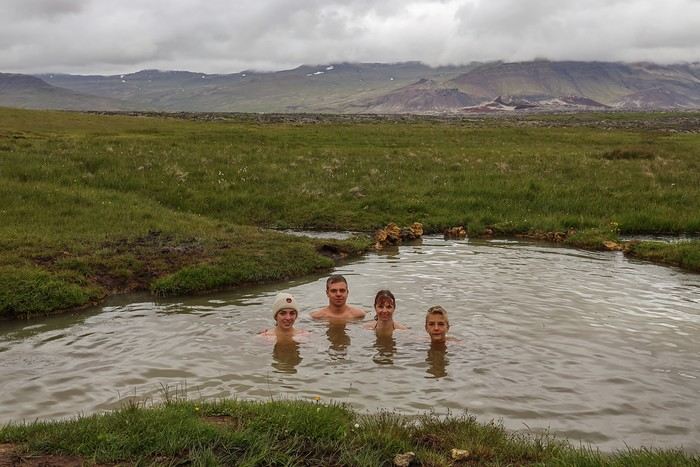
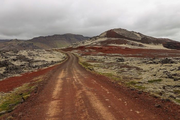
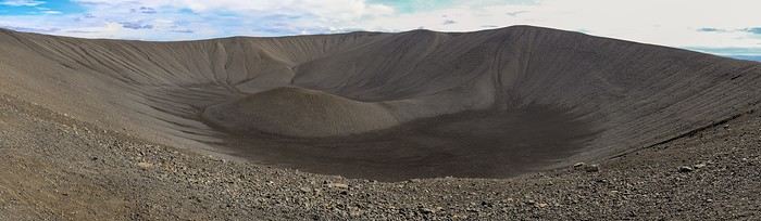
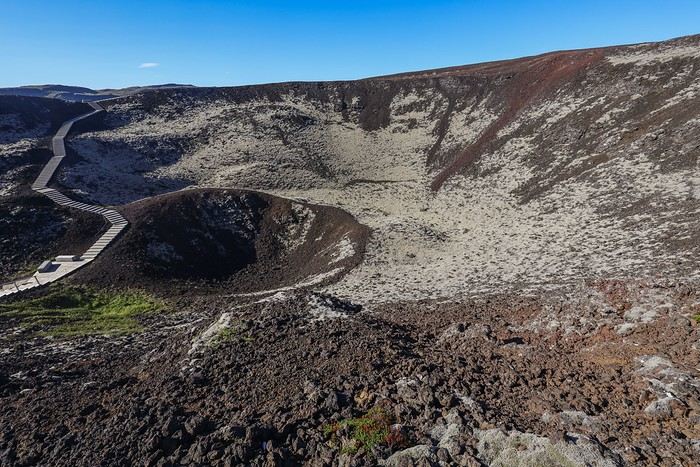
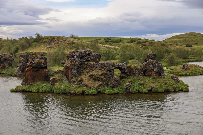
You could have fun climbing up and down these pseudo-craters covered in moss, but the wind blowing so hard it could knock the horns off a bull doesn’t exactly encourage us to linger!

We continue our loop around the lake. A short distance away, we stop at Höfði, another interesting site by Lake Mývatn, located on a peninsula with strange lava formations and plenty of trees.


In one of the lake’s coves along the park, you can admire lava pillars covered in orange lichen rising out of the water, called Kálfastrandavogar. 
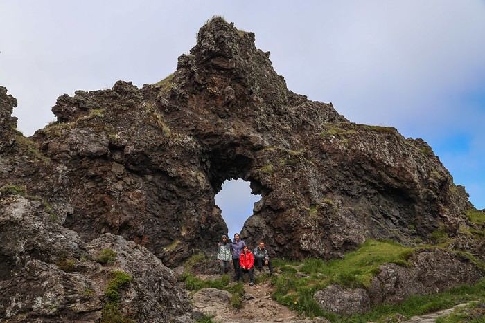
It’s possible to walk around the peninsula via a small hiking trail. Even though this might seem common in Europe, seeing trees in Iceland is actually pretty rare!

After leaving Mývatn, we take Route 1 for about twenty kilometers before turning onto Route 862, which will lead us to Iceland’s most powerful waterfall duo: Dettifoss and Selfoss!

Once there, the parking is free—something that’s been pretty rare since the start of the trip! However, one thing that hasn’t changed since this morning is the wind, blowing extremely hard from inland. As soon as we step outside, we get blasted with dust and sand in our eyes!!

The approach hike becomes really tough.

A view to the north and the sprawling Selfoss waterfall... You can see all the sand being carried by the gusts!

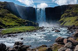
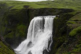
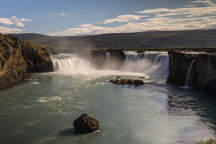
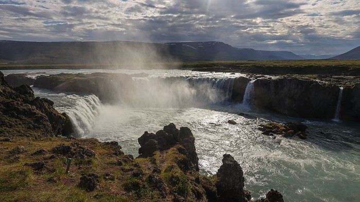
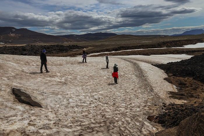
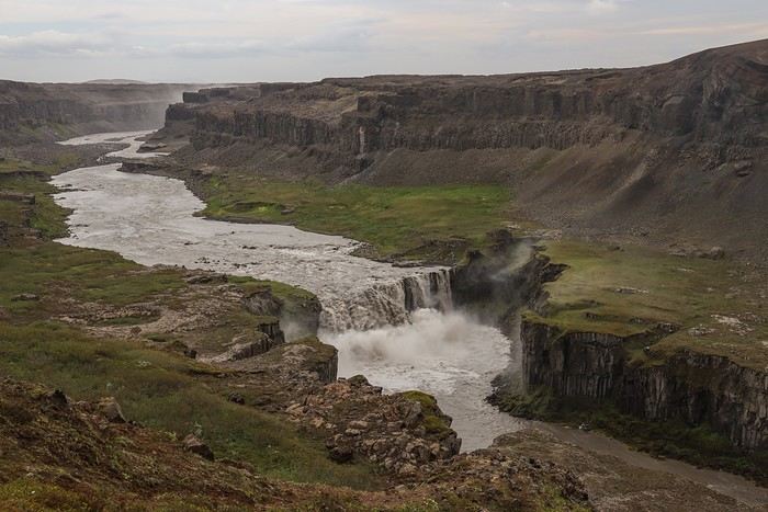
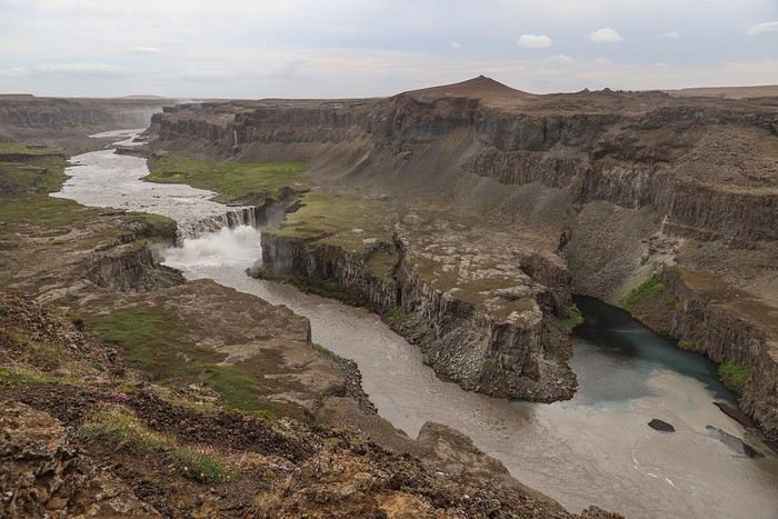
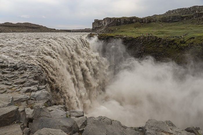
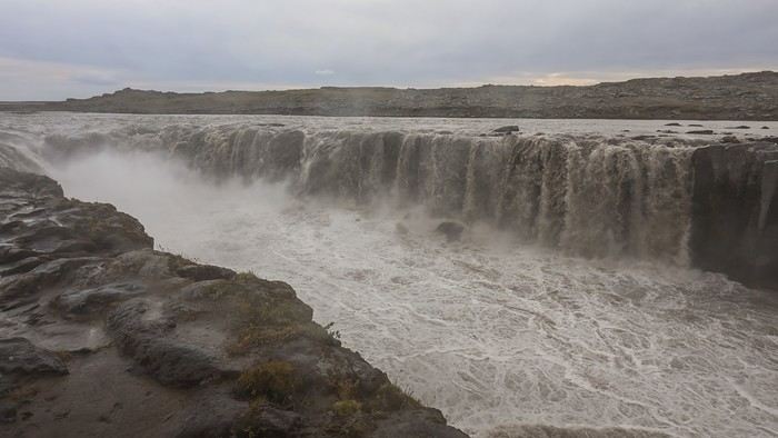
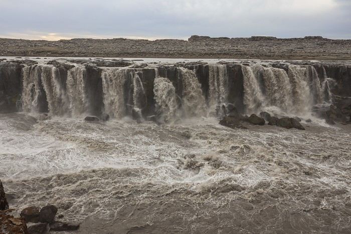
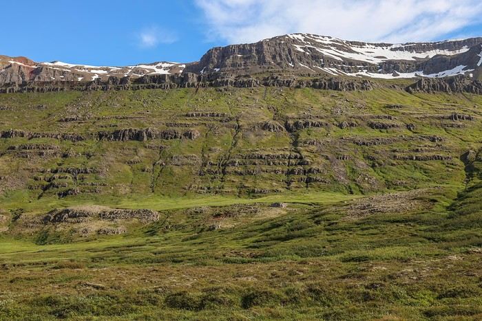
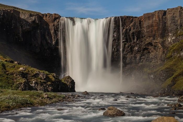
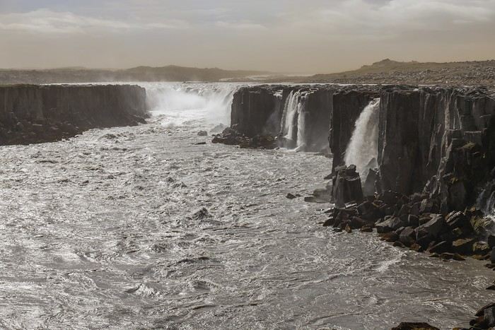
We’re all tempted to head straight to the majestic Dettifoss, known as Iceland’s—and even Europe’s—most powerful waterfall. At 44 meters high and 100 meters wide, the falls have a flow rate of 500 m³ per second in summer, when the flow is at its strongest.

We’re here at just the right time to take it all in, and we feel tiny next to it!

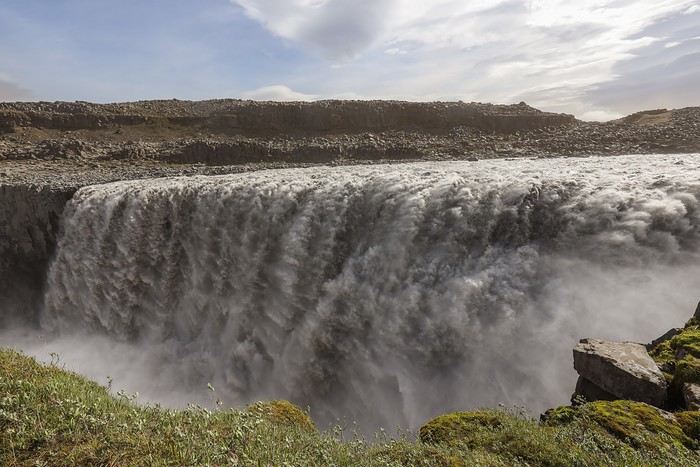
Following the trail south towards Selfoss, the wind doesn’t let up... we’re eating sand over and over, and woe to those without sunglasses. Even squinting, the poor souls end up in tears...

The return from Dettifoss is so unpleasant that we all agree a distant view of Selfoss is enough. Anyway, we’re planning to come back very soon via the opposite bank, and we figure the view from there should be even better!

So we cut the visit short and head, still along Route 862, towards the Hljóðaklettar parking lot.

A "two-in-one" hike awaits us there. Even though the main goal is Rauðholar, a mountain with red and black slopes, we’ll reach it by crossing remarkable basalt formations.


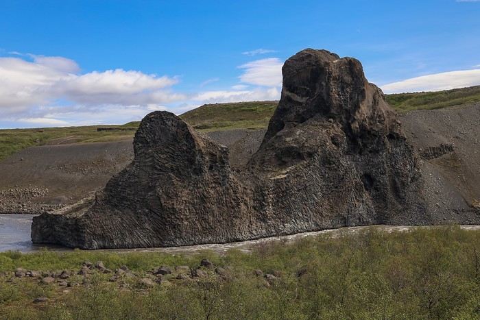
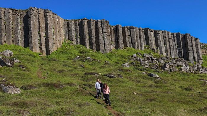
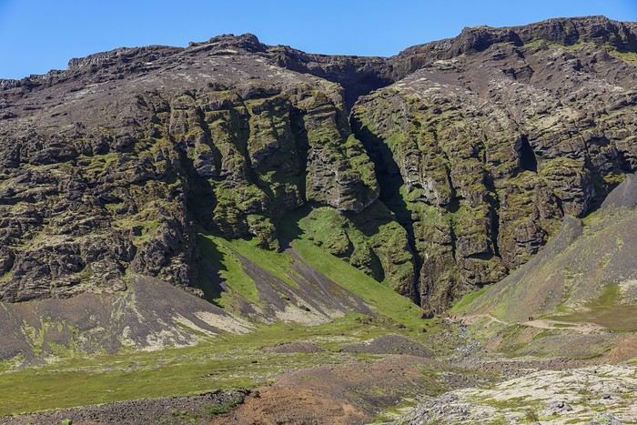
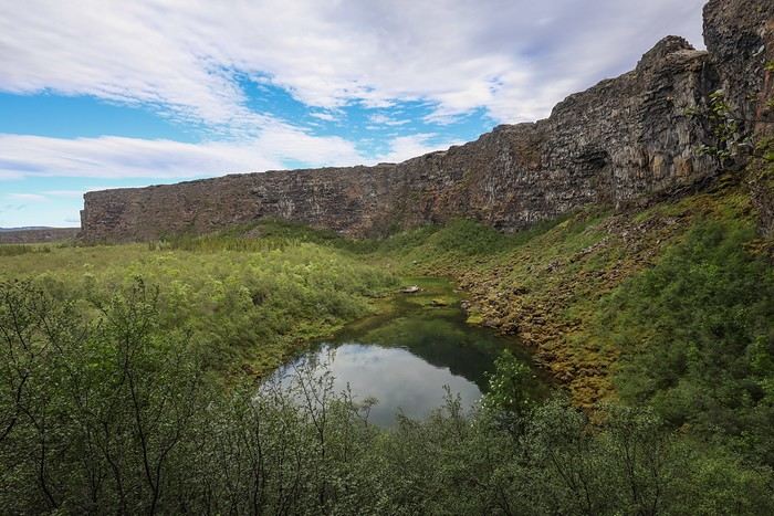
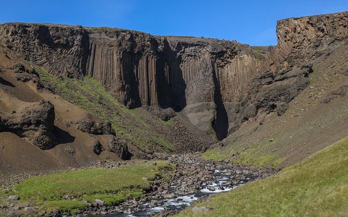
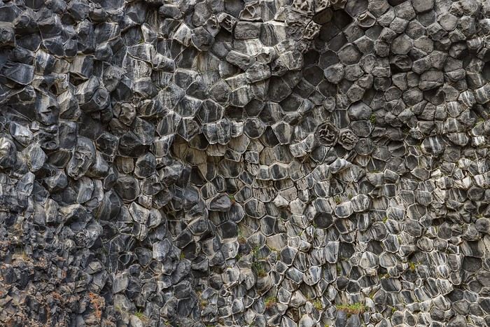
Volcanic chimneys and other basalt columns follow one after another

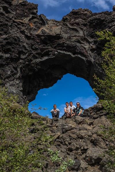
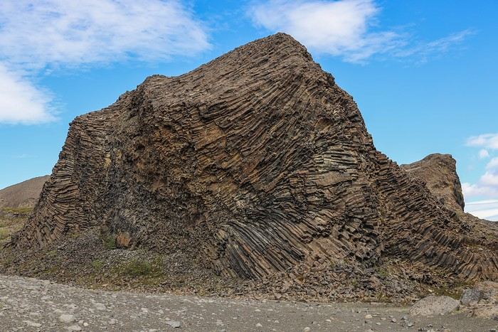
until we reach Kirkjan in Hljóðaklettar, a cave-like formation and the main highlight of the hike. You can just imagine the pressure that caused this lava flow to lift...


The trail takes us higher, and we reach the viewpoint over Rauðholar, offering a panorama of the Jökulsá gorge and the forests surrounding Ásbyrgi.

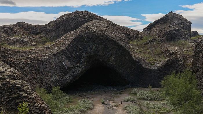
It’s now forbidden to venture further to avoid damaging the site and keep the slopes free of footprints. The return is via another path, much less steep and quicker.
MA
The days are definitely very long in July, which lets us make a detour to the Ásbyrgi canyon. You can access this natural amphitheater from the top or the bottom. Since the bottom access is much easier, that’s the option we go for.

A short 15-minute walk takes us to the little Botnstjörn pond.


You can also get a nice view of the pond from a platform under the western cliff of the canyon. A stone staircase leads to a small hill where the view of the canyon is stunning.


The scenery changes when we arrive in Húsavík, the capital of the North, located at the very edge of the Arctic Circle.

After pitching our tent for the first time at the municipal campsite, we hurry to the harbor, the starting point for so many activities!


A few typical buildings... This restaurant catches our eye, but a quick look at the menu cools us down—even the most basic dishes start at 30-35 €...


We decide to head a bit farther out and eventually find our spot at a pizzeria with more reasonable prices, though dinner ends up being just... pizza.

Yep, the prices for more elaborate dishes are mind-blowing and way out of our budget, especially for five of us. [:/]
MA
J7 - 07/12: Whale Watching - Dettifoss - Selfoss

Ten years... Ten years already since I first promised the family we’d go see whales.

And yet, we came up empty in Scotland in 2014. Same in South Africa in 2016. In 2021, in Mexico, it was Maxime’s health issues that kept him from swimming. So there was no way we were going to swim with whale sharks and leave him behind...

So here we are, setting off on this whale-watching excursion, ready to break the bad luck!


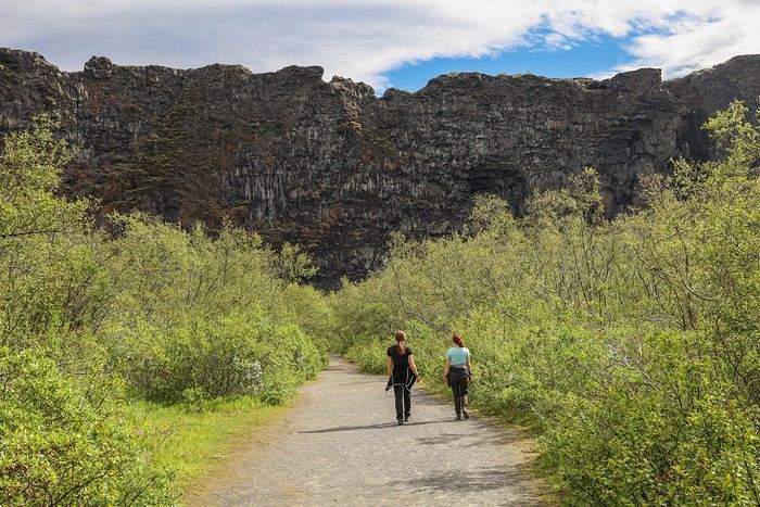
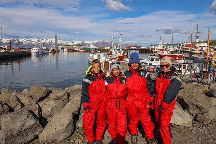
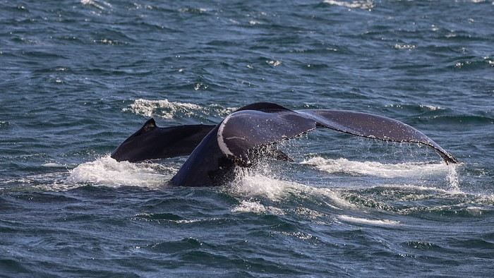
As the boat’s name suggests, we chose the tour operator "Friends of Moby Dick."

Off we go for a 3-hour ride. The weather is perfect, just like almost every day since the start of the trip. A glassy sea... our stomachs are grateful. I’d read quite a few accounts of people getting sick depending on the weather conditions.

Facing us, the impressive Kinnarfjöll mountains on the other side of the bay.

After half an hour, we’re rewarded with the sight of a humpback whale and her calf—!

The guide doesn’t hold back on the superlatives and tells us we’re *extremely* lucky to see a mom with her baby! We don’t *have* to believe her, knowing that Húsavík is famous for being the whale-watching capital of Europe...

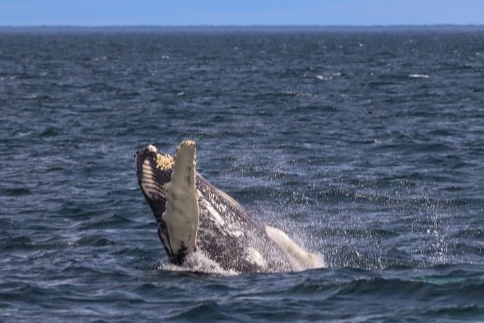
The whale treats us to several jumps out of the water. I just manage to capture it— !


We stay with this pair for a while. A few playful moments that let us see their pectoral fins as they pivot...


Sometimes, the whale and her calf pop their heads out of the water at the same time.


And a fluke shot—not as easy to get as you’d think...

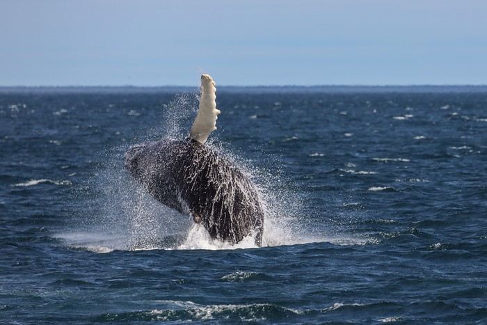
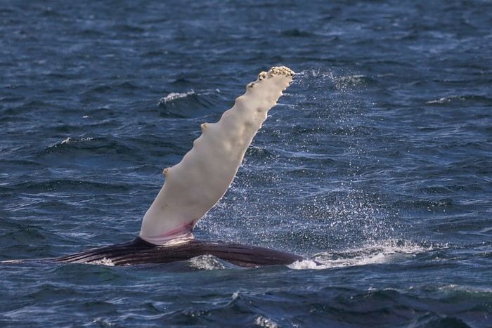
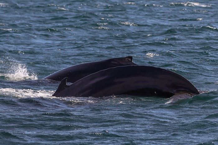
After about an hour spent with this pair, with the guide’s excited exclamations keeping everyone’s attention, we think we spot a huge shape in the distance. The boat’s captain hurries to approach another boat.

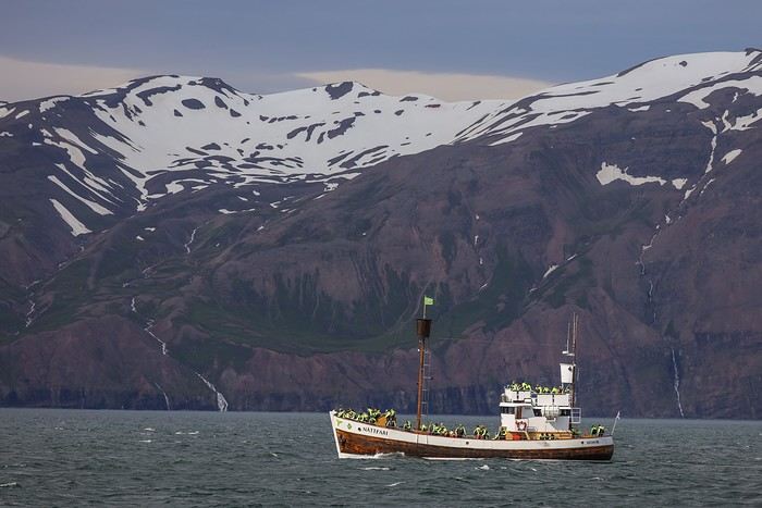
A few minutes later, we see a massive blue-gray shape emerge from the water. No doubt about it—it’s a blue whale, the largest mammal on the planet!

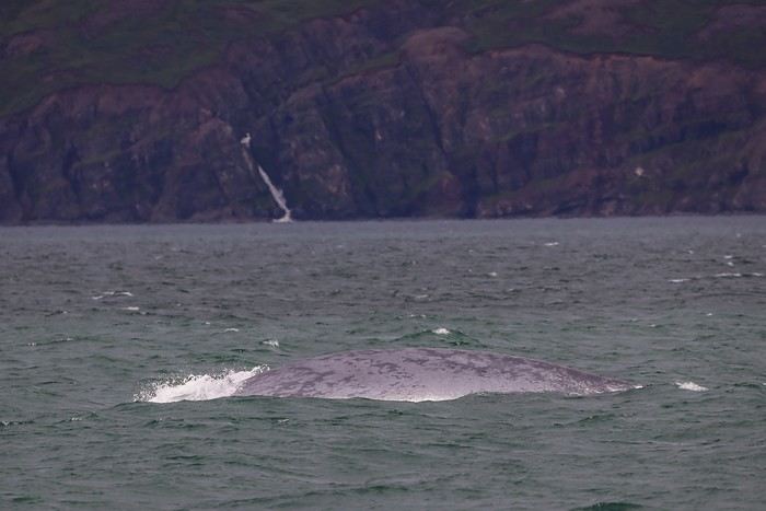
The big challenge with blue whales is that they stay underwater for a good 15 minutes without coming up for air. So it’s a bit of a lottery to be near the spot where they’ll resurface. Every time they come up, there’s a big cheer from the crowd, the captain guns the engine to get closer, a few mediocre zoom shots are taken from too far away, and then another 10-15 minute wait...

MA
At this little game, another hour quickly passed, and we had to hit the road back to the port of Húsavík.

In one of the few clothing stores in town, we took the opportunity to buy Maxime a third pair of shoes—sneakers this time. He’d had the bright idea of not wanting to break in his two pairs of high-top Gore-Tex hiking shoes before the trip, insisting everything would be fine, and ended up with sore Achilles tendons in both pairs 😠.

Given the hikes we’ve got coming up in the next few days, it’s better to plan ahead...

Instead of continuing along the north coast toward Raufarhöfn as originally planned, we decided to take it a bit easier by cutting down on travel time. So, we headed straight toward the center of the island, taking Route 864.

Along the way, we were set for another encounter with the famous Dettifoss and Selfoss waterfalls—but from the other bank.

From this side, you can easily access a third waterfall, Hafragilsfoss, downstream from the two better-known ones.

We didn’t pass up the chance, and found ourselves all alone, far from the crowds gathered in front of its two sisters!


You can see the thick mist from Dettifoss in the distance.


We parked a bit farther away to take the walk to Dettifoss, which wasn’t showing its best side.


On the other hand, the angle was perfect for the multiple cascades of Selfoss.

I was the only one brave enough to get that close—my clothes and DSLR were getting soaked fast from all the water and mist spraying everywhere! The rest of the family wisely waited about a hundred meters away...


For the night, we stopped at the Fjalladyrd campsite, in the middle of nowhere. No hot water in the little hut for cooking or doing dishes, but at least the showers were nice and hot...
MU
This latest waterfall is incredible! And how lucky we were to see a blue whale! 🤩
Si tu diffères de moi, mon frère, loin de me léser, tu m'enrichis (Saint Exupéry)
MA
Muriel, We were actually lucky with the whale watching this time, after all these years of trying [;)] !
MA
Day 8 - 07/13: Studlagil Canyon - Seyðisfjörður

For our first foray into the Highlands, what better than the Askja volcano and its famous milky-blue lake in the middle of a lava desert! Askja is completely isolated in the center of Iceland, far from any town and main roads, and we’ll need to take dirt tracks for over 2 hours.

Today is the first day the F910 track opens, so we’re not going to miss out! There are even one or two cars ahead of us at the campsite, heading into the heart of the island.

We leave the small hamlet and its typical houses behind,

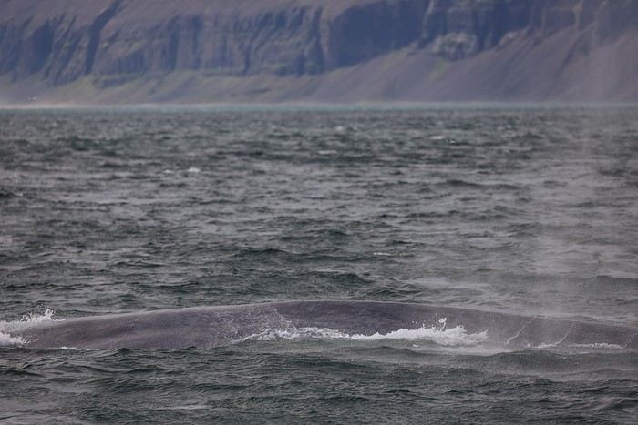
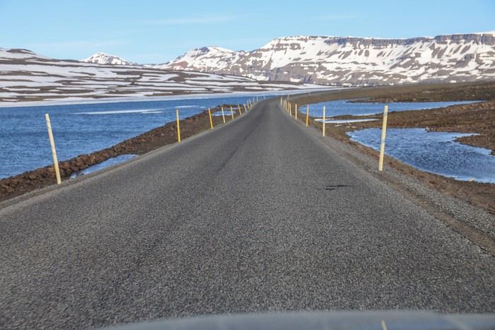
to take the F910. We drive at a reasonable distance behind a Landcruiser that lets us pass to snap a few photos.

It’s true that, despite the prevailing gray, a special atmosphere emerges

The first river crossing is a simple formality. However, the second one, about 30 km from the campsite at the start of the track, is deeper.


We proceed slowly but steadily. The riverbed isn’t smooth—there are a few rocks. It’s bumpy, really bumpy. As we exit the water, we hear a hissing sound...

Quick, I roll down the window, and unfortunately, there’s no doubt—we’re getting a flat! And not just a little one...

We pull over to the side to look for the puncture. No need to search long—the tire’s sidewall is torn. Ouch, ouch... Looking back, I think the motorcyclists who crossed the river just before us might have moved some big rocks while accelerating in the riverbed.

A quick glance at my smartphone—no network coverage. No way to call our rental company, so we’ll have to figure it out on our own!

All that’s left is to empty the trunk, searching for the spare tire. And when we lift the trunk floor, in the space meant for the spare, we find... the battery of our hybrid SUV, with just some kind of canister we have no idea what to do with !!!

We really look like newbies! Even though we’re used to off-road trips, I didn’t think to check if the SUV had a spare tire when we picked it up! Newbies, I said ...

Knowing the vehicle is approved by our rental company, Lava Car (I’m repeating the name for anyone listening...), I never would’ve imagined it wouldn’t come with a spare tire!!

The people in the Landcruiser following us closely—French tourists—stop to offer help. Not much use, since they can’t lend us their spare tire. They just seem relieved they spent 5000 € on renting a real 4x4. Yeah, that’s the astronomical price you pay to drive stress-free in the Icelandic Highlands [:/]!

Since we always have a plug kit in our luggage, I insert one into the hole. Not enough... I add a second, being careful not to push the first one inside the tire. Still not enough—there’s some play. Finally, with a third plug, it seems to hold, but we wonder how long it’ll last once we’re driving and the tire is inflated.

I then pull out our compressor, which we always carry, to slowly inflate the tire. At 1 bar, it holds... 1.4 bar, still holding. Not wanting to push our luck, I stop at 1.7 bar, as if we were driving on sand.

We turn back—it’s clear we’re not risking the adventure to Askja anymore. Our goal is simple: cross the river again without losing our plugs, then reach civilization.

This second crossing is even slower, but luckily, we don’t hit any new rocks. As we exit the water, we stop immediately—happy surprise, the plugs held, no hissing!!

We drive at a max of 30 km/h on the F905 track heading north, then turn right onto Austurleid, aiming to reach Studlagil Canyon calmly.

This detour means more off-roading, but if the plugs held for 10 km, why wouldn’t they hold for 50 km? Luck is on our side, and we reach Studlagil without any other issues—plus, there’s network coverage here.

We’ll call the rental company later. We park in the paid lot closest to the canyon, on the south bank. To park for free, you’d have to add a 4.5 km round-trip walk. Between a 1-hour walk and 1000 ISK (7 €) for parking, my knee made the choice quick. Laetitia too, for that matter!

Almost unknown 5 years ago when I planned the first version of this road trip, Studlagil Canyon is now super famous thanks to its Instagram-worthy vibe! They’re even paving the access track!

After a quick picnic in a meadow, we start the 2 km walk along the canyon—pretty nice, with several waterfalls to keep us entertained.

No surprise, we’re far from alone on the trail!

At the end, we start to understand why

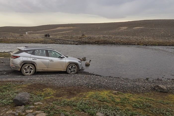
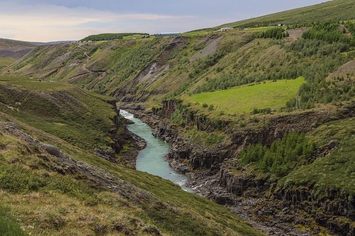
Here are the first basalt columns lining the turquoise-blue waters of the Jökla River!

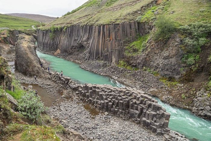
The most incredible part? This canyon was completely unknown in 2017... It was only after the 2009 construction of the Hálslón reservoir and the massive Kárahnjúkar hydroelectric plant further south that the basalt columns, previously underwater, were revealed!

What makes this canyon special is also the stunning, ever-changing color of the waters flowing through it. On some summer days, the Jökla’s water is crystal clear, taking on a turquoise-blue hue that leans toward emerald green. Other days, the color tends more toward a dark brown-green, less photogenic.

Looks like we hit a good day...!

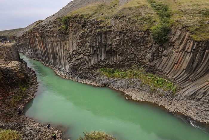
We can’t get enough of these basalt columns from every possible angle!

Across the way, the view from the north bank—way less photogenic, as you can imagine from what those tourists are seeing from the esplanade.

Back at the car, we head toward Egilsstaðir, the area’s biggest town. On the way, we call Lava Car to explain our flat and ask which garage in Egilsstaðir we should go to for a tire change.

After another hour of driving at 60 km/h on a road where everyone happily passes us, we finally find the garage. Once there, we have to call the rental company again—they want the mechanic to confirm the tire change is really necessary...

Since a picture’s worth a thousand words, here’s one for you!


I’ll let you imagine the mechanic’s face when he saw the makeshift repair!! He then found the right words to get the rental company’s approval to change the tire... Good thing we took the Full Protection option—it didn’t cost us anything. Then again, since we always have car troubles, we cover ourselves as much as possible.

After hanging up, he asked how many kilometers we’d driven with those plugs. When I told him 170 km, he was impressed, almost shocked !!!

While waiting for the repair, I suggest the family take advantage of the mild coastal weather and camp in Seyðisfjörður, the prettiest town in the Eastfjords.

Everyone’s on board, especially with this amazing weather we’ve had since arriving in Iceland 8 days ago!

Around 5 PM, we take the pass on Route 93 with the setting sun. At the top of the pass, the landscapes are just stunning!!

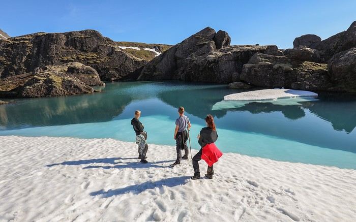
While most drivers speed along the road, we prefer to wander near a lake still partially frozen and covered in ice sheets. What a country!!

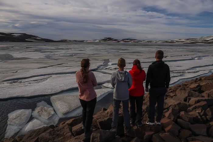
A little further, another lake, another scene!

MA
As we descended the pass, our eyes were drawn to the mountains covered in moss and grass,

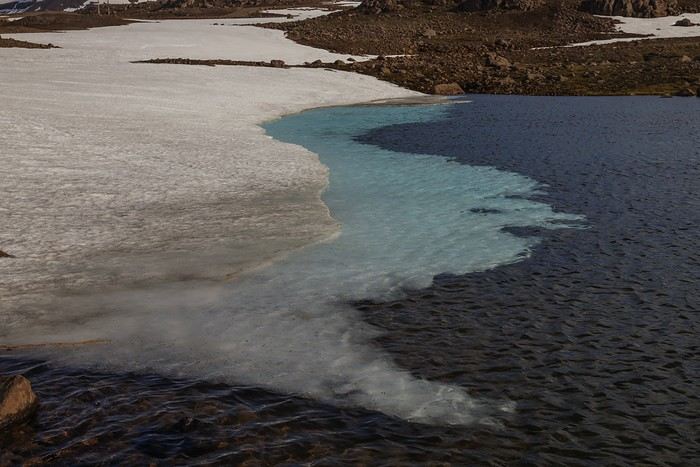
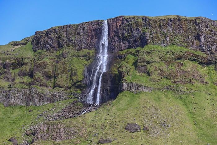
but especially to the stunning Gufufoss waterfall, sending up its plume of mist amid the greenery!


Our first mission in Seyðisfjörður was to find the municipal campsite, included with the Camping Card, which means it’s free for all annual cardholders (at 170 €). As expected, it was packed, and we had to skillfully maneuver the car to find a makeshift parking spot and pitch our tent on a pseudo-campsite.

Once the tent was up, we headed to the reception to pay for our night and the showers.

Then, we wandered into town.

Seyðisfjörður is a charming little fishing port with colorful houses nestled at the end of one of the Eastfjords, giving off a real "end of the world" vibe! We instantly fell in love with this idyllic setting...

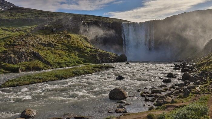
Tourists were sitting at outdoor terraces enjoying a drink, kids were playing in the green spaces, and Icelanders were having fun canoeing on the Lónið, a small lake that connects the river to the ocean...

At the end of the rainbow-colored main street stands the village’s quaint church, built with sky-blue corrugated metal walls.


What to say about this end of the day... We were supposed to camp by Lake Askja and would have likely slept under a gray, overcast sky. But Iceland’s incredible variety in scenery, atmosphere, and landscapes made this backup evening in such a charming spot so enjoyable—almost making us forget the missed rendezvous with the volcano...
MA
J9 - 14/07: Puffins at Borgarfjarðarhöfn - Stórurð hike

Since the Askja trip was canceled, we already covered the long road to Egilsstadir yesterday, and now we can explore more of the area north of Egilsstadir, including a last-minute discovery hike that’s an absolute must...

Before leaving Seyðisfjörður, we head down the Skalanes road along the south side of the fjord.

A few friendly encounters,


Then we decide not to risk crossing a ford just a short distance from the end of the track, and turn back promptly—today, we’re hoping to spot our first puffins of the trip!

Another stop at Gufufoss waterfalls, which look even more magical in the early morning light


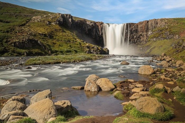
One last glance at the fjord,

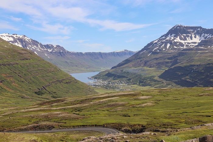
and we head back to Egilsstadir, pass the garage again, and take the road north.

I’d noted two stops along the way: the first is Geirsstaðakirkja, a traditional chapel with a thatched roof guarded by a few sheep,

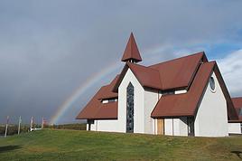
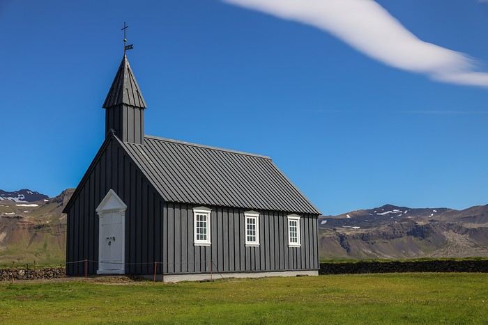
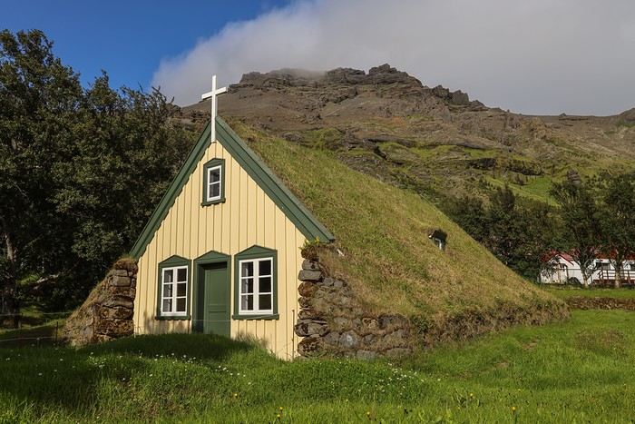
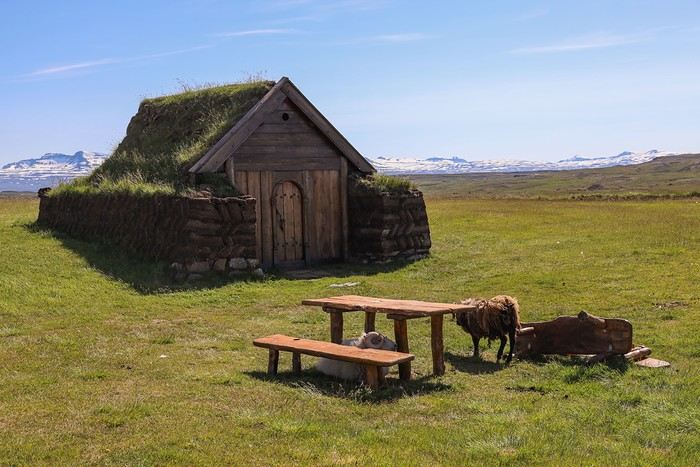
The second is Kirkjubæjarkirkja, a black-painted church with a red tin roof, completely isolated in the middle of nowhere. There’s not a soul for miles around.


We make one last stop on Route 94 in the small village of Bakkagerdi for a photo of a traditional turf-roofed house that’s been my desktop background on one of my PCs for months!

Its name is Lindarbakki—you can’t miss it, as it’s right by the main road!

In my opinion, the most beautiful house we’ve seen in Iceland... What charm, a real postcard !

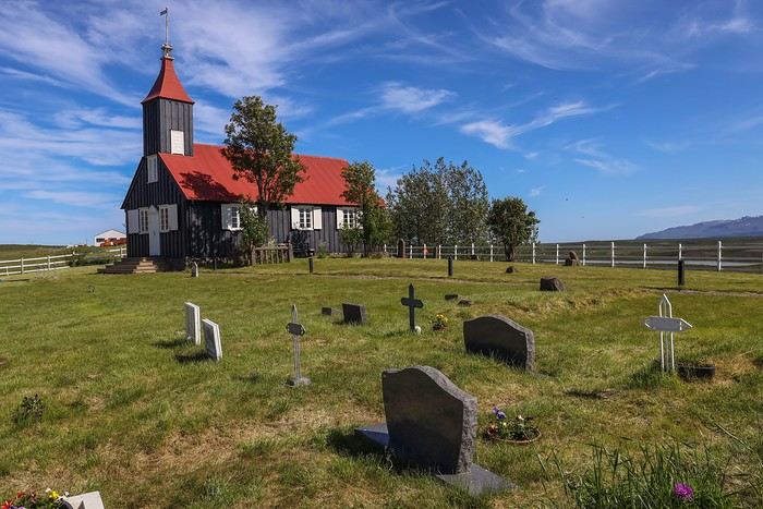
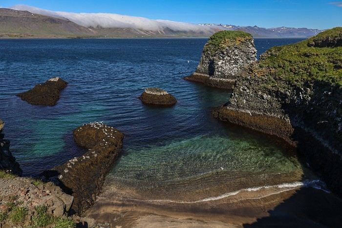
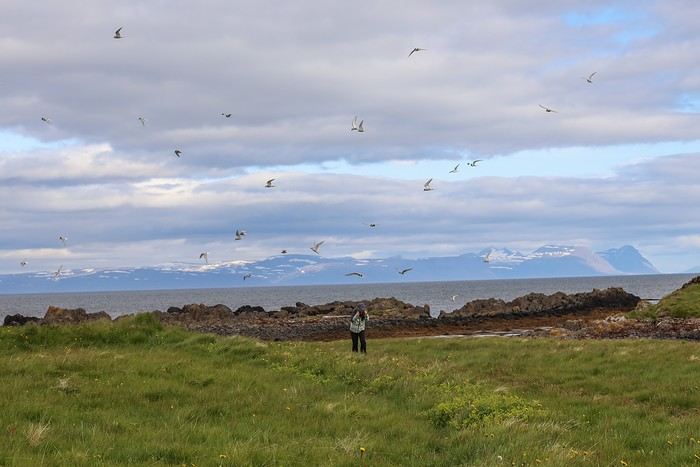
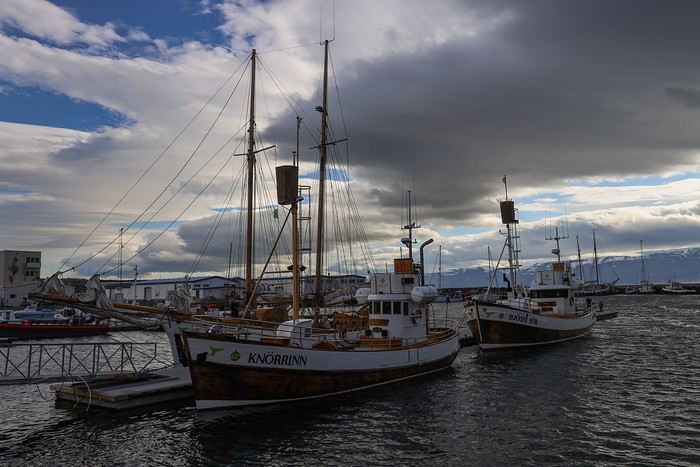
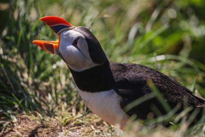
And here we are at Borgarfjarðarhöfn harbor,


where, after a quick picnic, we take the short trail leading to the peninsula famous for hosting one of Iceland’s largest puffin colonies!
MA
Going to Iceland without seeing puffins is a bit like going to Peru without visiting Machu Picchu ! Okay, fine, I’m exaggerating a little...

The area is well laid out: wooden stairs and paths, railings to avoid disturbing the puffins in their natural space, and even an isolated observation post with openings to better watch the birds and set up your zoom lens.

The puffins were out in full force for our delight. We were lucky—even in broad daylight, they were very active.


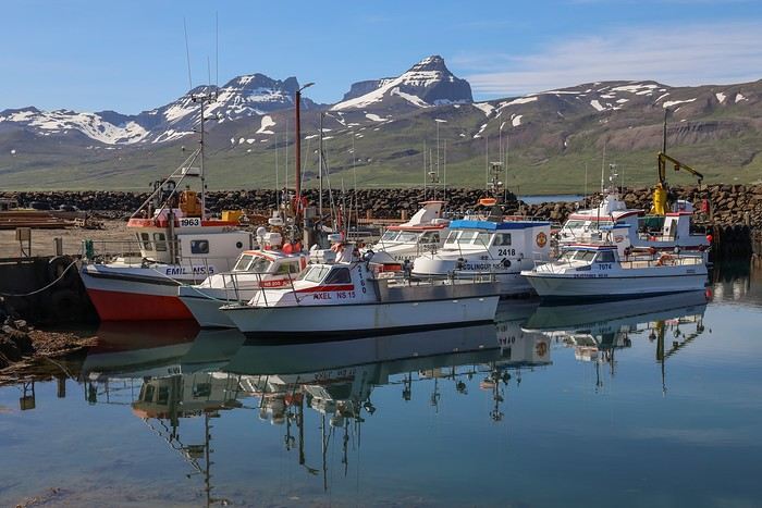
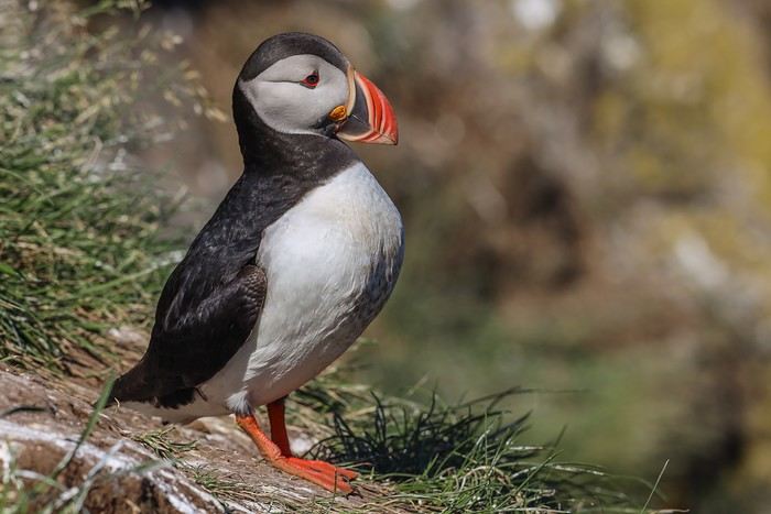
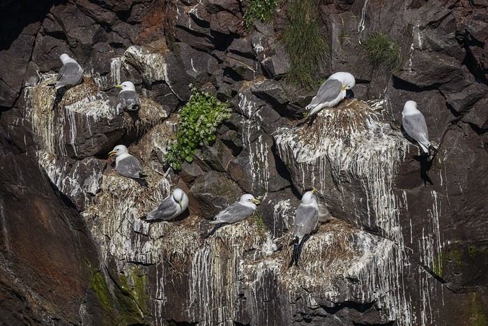
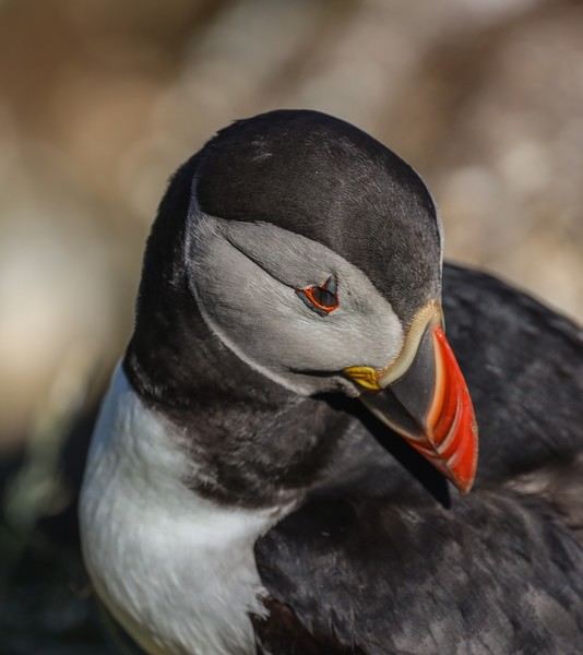
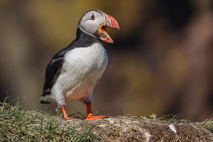
These birds are hilarious and not at all shy—some even come within a few dozen centimeters of us without fear.

Their routine is always the same: take off, dive into the water, go catch a few fish, then bring them back to their pantry.

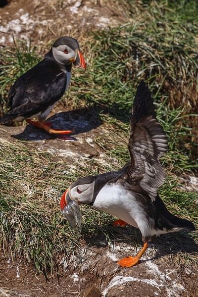
This was the first time I realized how limited my camera is. I don’t know if it’s the body or the speed of the lens’s autofocus, but I could barely get a sharp shot. Oh well, let’s just say the puffins are too hyper...

Some specimens are deep in meditation or just resting.


Others are singing, scratching, or busy fishing.


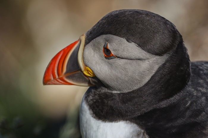
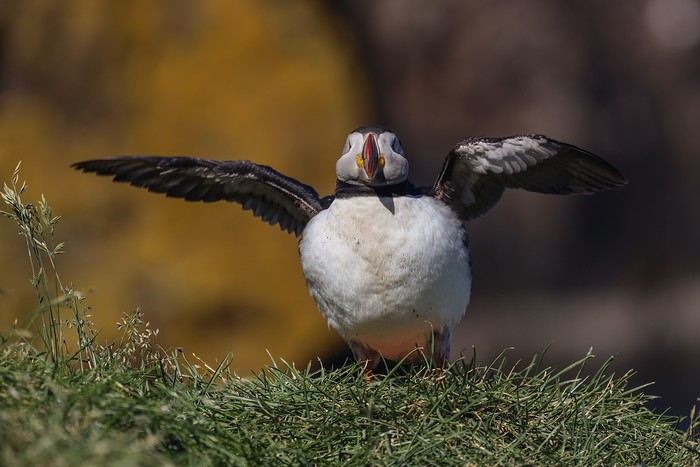
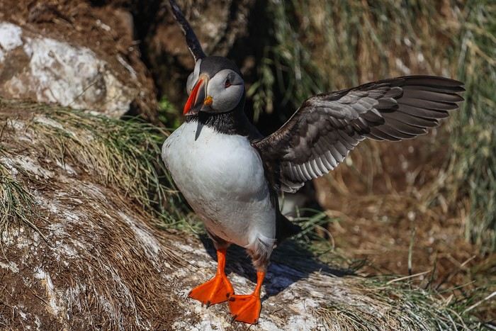
After an hour and a half of observation, we tear ourselves away from this magical place—definitely one of our best travel memories! !
MA
Heading to the trailhead for the Stórurð hike, or "Giant Rocks," some photos of which I came across just days before our departure and really got my mouth watering. Actually, the difficulty of access was as much of a draw as the photos of the turquoise lake at the summit, but I’m keeping that quiet from the family...

There are three possible routes: hikes #9 and #10 are around 5-6 km one way with a steep elevation gain and technical sections, while #8 is 7.5 km one way but with a constant gentle incline, making it easier on my knee despite the extra distance. At the trailhead, we learn that the hike is discouraged in favor of #9 and #10 to protect the vegetation, but it’s not forbidden.

We decide to go for it anyway, even though it’s already 3:30 PM and we’ve got at least 16 km of hiking ahead! Is this really a good idea? Probably not, but since we won’t be back in the area for years, we might as well be adventurous!

The approach walk, which was supposed to be less scenic, is still pleasant with great views all along, plus several streams and marshy areas to cross.

What a view of the coast!

Some waterfalls have a stronger flow and are trickier to cross.

As we get closer to the stunning, rugged mountains of Dyrfjöll, the ground becomes increasingly damp, even spongy, and our sneakers take a beating...

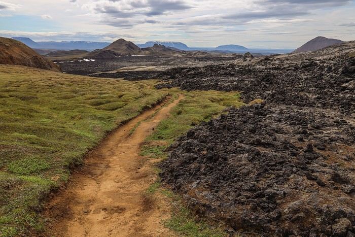
Once there, the loop winding around the lakes and mountain rivers with its meanders is just breathtaking!

The scenery looks like it was specially designed, even though it’s completely wild...

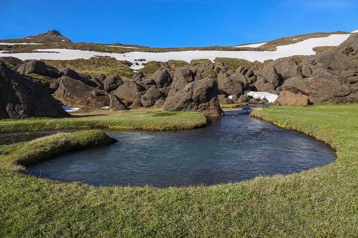
The last few hundred meters to reach Stórurð Lake feel really long—our legs are already tired. Some areas are still quite snowy. The huge rock formations become more and more frequent; we’re almost there [:)]


And around a bend, we reach our goal after 8 km of effort.

Stórurð, an oasis of turquoise pools surrounded by enormous boulders, whose origins date back to the last glacial period—these massive rocks were likely left here as the glaciers receded.

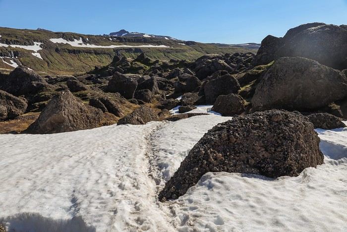
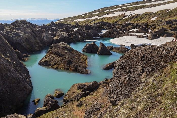
The view is stunning , leaving us speechless. Stórurð is undoubtedly one of the hidden gems of the Eastfjords, and we know we’re incredibly lucky to enjoy it under a clear blue sky and in T-shirts !!

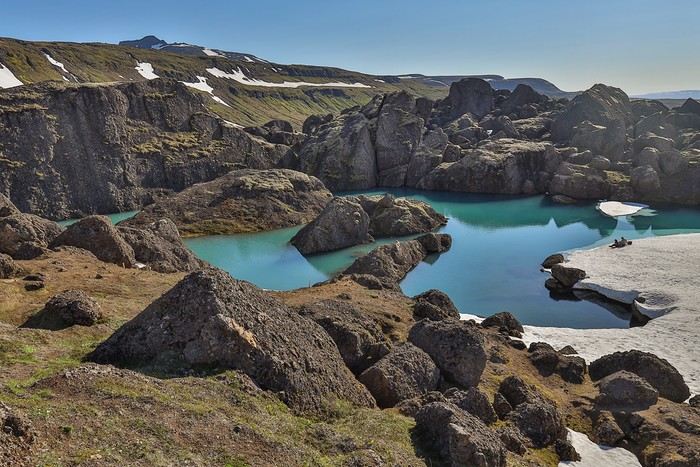
The light and color of the lake change as we get closer.

At the edge of the lake, thanks to the low water level over the ice blocks, the mix of white, sky blue, turquoise, and deeper blue gives the site an otherworldly feel.


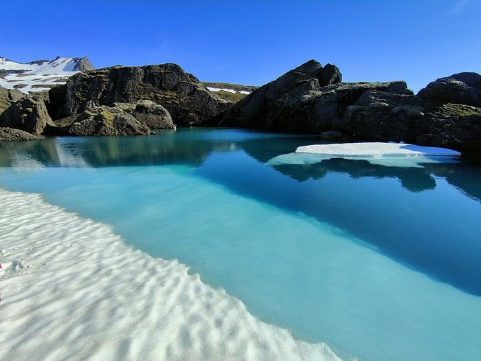
We could easily spend hours just gazing, but it’s 6:10 PM, and if we want to have dinner at a pizzeria in Egilsstaðir, we’d better get moving on the way back...

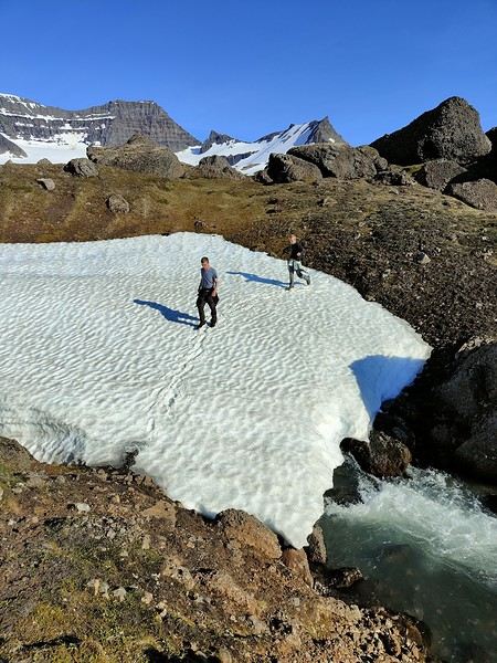
On the way down, the same green meadows, marshy areas, small ponds, and waterfalls, but we don’t take much time to stop—our stomachs are growling.

It was so warm in the late afternoon that our water supplies are empty. No problem refilling with crystal-clear water from one of the mountain streams [;)]!

At 8 PM sharp, after 1 hour and 45 minutes of hiking, we complete our 8 km of gentle downhill.

No time to waste—we quickly head back to Egilsstaðir and have dinner at Askur Tapromm and Pizzeria, which offers very reasonable prices for Iceland! Plus, the pizzas and beer are excellent, the perfect way to cap off one of our best days!!
MU
It's truly magnificent under the sun! (and probably even more so "in person")
Si tu diffères de moi, mon frère, loin de me léser, tu m'enrichis (Saint Exupéry)
DE
Hi Guillaume, Thanks for sharing your trip! Your story is captivating, especially with those amazing photos. I’m totally into it—it really makes me want to go!
RO
Oh! Glad your travel journal popped up in my reading suggestions... you didn’t even announce it 😅. I’ll read it when I’ve got a clear head because I can see I’m way behind, so I’m jumping in mid-journey with you all 😊. Iceland—what a stunning country! I never wanted to set foot there because of the cold, the rain... everything I *hate* 😂, but we ended up visiting twice in one year. I’ll share more once I’ve sorted through my photos 📸
"Voyager est un triple plaisir : l'attente, l'éblouissement et le souvenir." Ilka Chase
MA
It's truly magnificent in the sunshine! (and probably even more so "in person")

We were so lucky to do this hike in T-shirts under a radiant sky! Our French guide during our day at the glacier was simply amazed... and whispered that Stórurð was the best hike you could do in Iceland.

We were happy to believe him, until we reached Landmannalaugar or Pakgil...
MA
Hi Guillaume, Thanks for sharing your trip! Your story is captivating, especially with those fabulous photos. I’m totally into it—it really makes me want to go!

Hey Daniel, Welcome to this travel journal, a nice change from the ochre rocks of the West ;) ! I see you had to tweak your username a bit—first post and all... See ya!
MA
Oh! Good thing your travel journal popped up in my reading suggestions... you didn’t even announce it 😲. I’ll read it when I’m more relaxed because I see I’m way behind, so I’m jumping in mid-journey with you 😊. Iceland, a stunning country I never wanted to set foot in because of the cold, the rain... everything I love 😂, but we’ve traveled there twice in one year—I’ll tell you all about it once I’ve sorted through my photos 📸

Hi Isabelle, Thanks for joining in! I really should’ve posted something on my FB wall because it feels like fewer of us are automatically and regularly checking out VF. It’s too bad, really. I’ll happily read your future travel journal about this destination we loved, despite a few flops in the Highlands...
MA
Re: A sunny summer in... Iceland!!
Day 10 - 15/07: Hengifoss Waterfall - Mjóifjörður Fjord

This morning, we had breakfast on the terrace of our BnB "Hof," which offered a stunning view of Lake Lagarfljót. Who would’ve thought we’d be having breakfast in T-shirts in Iceland!? We’ve been traveling for 10 days, and it’s been sunny almost every single one!

We’re not getting too cocky, though—the forecast for the next few days is taking a turn for the worse just as we’re heading into the "must-see" spots... Pakgil, Jökulsárlón, Landmannalaugar, and more.

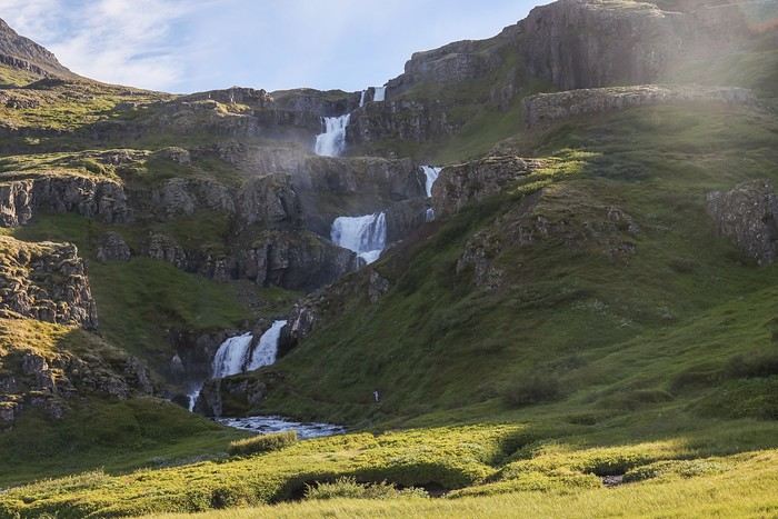
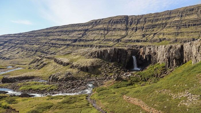
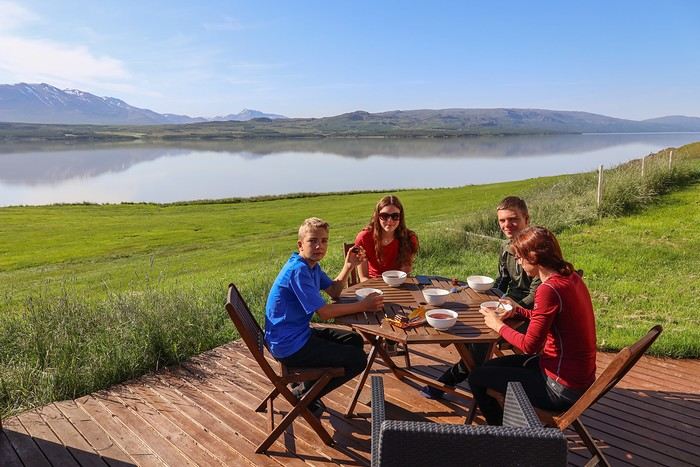
In the area, there are two remarkable waterfalls: Hengifoss, which faces east (so best in the morning), and Strutsfoss, which faces west (planned for this evening if we feel like it).

To get to the Hengifoss trailhead, we drove along Lake Lögurinn. When we arrived, the parking lot was packed.

No surprise—it was past 10 a.m., the hike is relatively short, and it’s the third-tallest waterfall in the country on the classic tourist route.

Halfway there, we stopped for a photo at Litlanesfoss, nestled at the base of a cliff adorned with basalt columns!

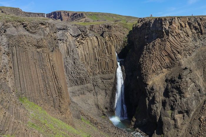
Then, after a steady and easy climb, Hengifoss revealed itself—a 120-meter waterfall set in an amphitheater of red and black rock strata!

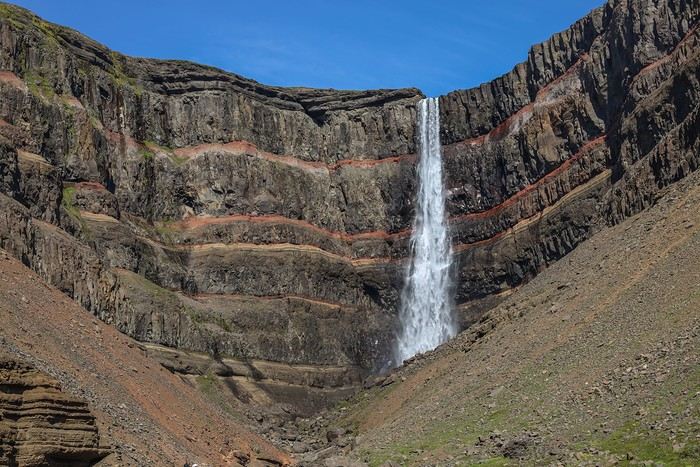
The descent gave us a chance to enjoy some gorgeous views!


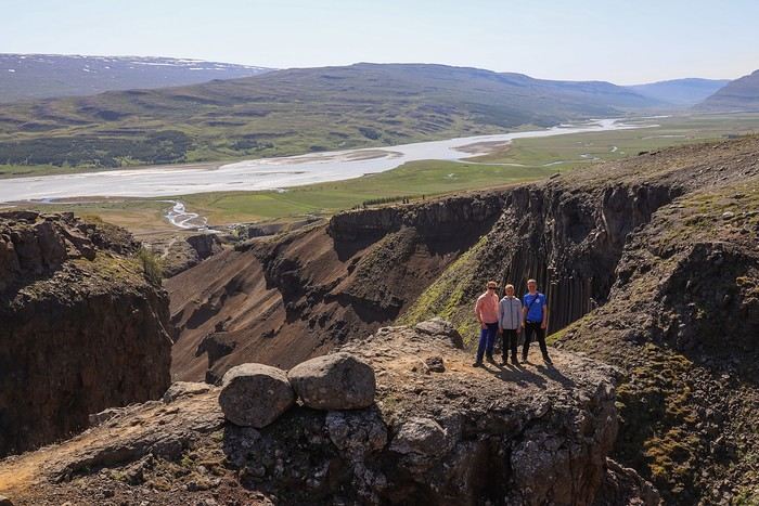
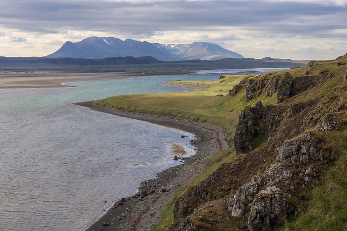
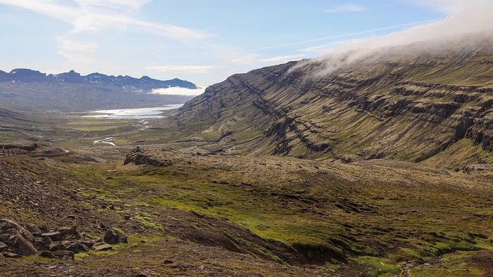
After Seyðisfjörður Fjord, the second fjord I absolutely wanted to visit was Mjóifjörður—a remote, little-known, and therefore barely visited spot!

We had to take a small unpaved road and cross a mountain pass.

The access road was stunning! At the top of the pass, there were still patches of snow on the ground and ice.

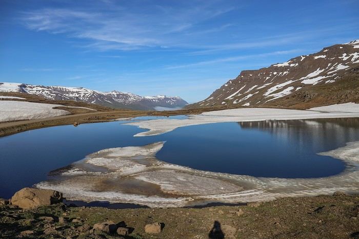
As soon as we crossed to the other side, we were treated to an absolutely breathtaking panorama of the fjord!!

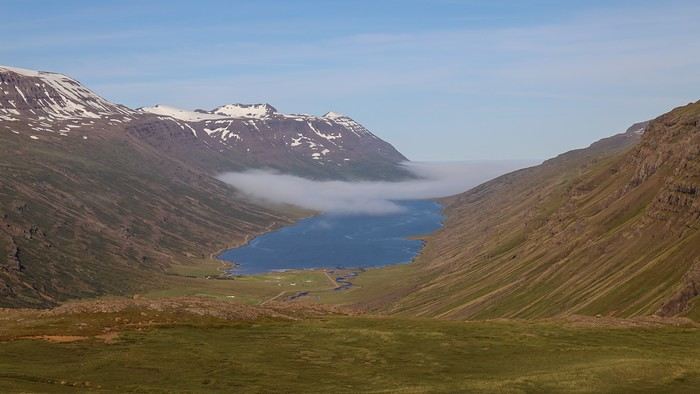
We drove through beautiful meadows, with lingering snow patches and several waterfalls cascading down the mountains. The narrow dirt road wound down the pass into the fjord after an impressive number of switchbacks.

Halfway down the fjord, we couldn’t miss the stunning Klifbrekkufossar. With at least 6-7 visible cascades from the roadside, the waterfall tumbled down the cliffs in a lush green setting. Everyone was enchanted!


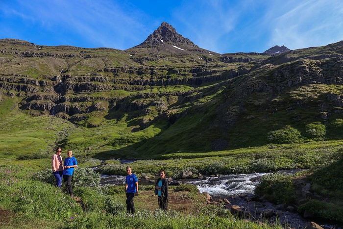
Once we reached the edge of the fjord, we easily spotted the wreck of an old boat that’s been stranded since 1966 and rusting ever since.


For once, we’re going to bend the rules—no one’s really up for visiting another waterfall, Strutsfoss, which is *supposedly* a little less impressive than Hengifoss... The rest of the day will be relaxed, with no other activities planned besides dinner at our BnB.
MA
Re: A Sunny Summer in... Iceland!!
Day 11 - 07/16: Viking Village - Jökulsárlón - Fjallsárlón

Today, we’re heading into the southern region, the most touristy part of the island, and strangely, the accommodation options are really limited. Supply and demand have done the rest, and it’s super tricky to find places to stay for less than 400-500 € per night...

So, I built the itinerary backward, starting by searching—often for a long time—for budget-friendly stays, still around 200-300 € per night , then planning the day’s schedule around them!

Our next stop is Svinafell, so a long day of driving awaits. For once, to leave the Eastfjords, we’re cheating on the Ring Road (Route 1) by taking a shortcut via Route 95 and then Route 939.

The latter, more of a gravel road, is famous for its landscapes, with several waterfalls.

Its reputation isn’t overrated—the descent toward the coast is absolutely stunning!


Route 1, which runs along the ocean, offers beautiful views. We stop at Hvalnes Nature Reserve without really knowing what there is to do there. Not much, apparently, except for a walk along the strip of land...

Our next stop is a reconstructed Viking village nestled at the foot of Vestrahorn Mountain, which is 10 million years old—one of the few mountains in Iceland made of gabbro, the main component of the lower oceanic crust. The oldest evidence of human life in Iceland was found here.

The light and the color of the rock are almost surreal—we love it...


Fun fact: this village is artificial and was created in 2010 for a film with Mel Gibson that was never actually made.

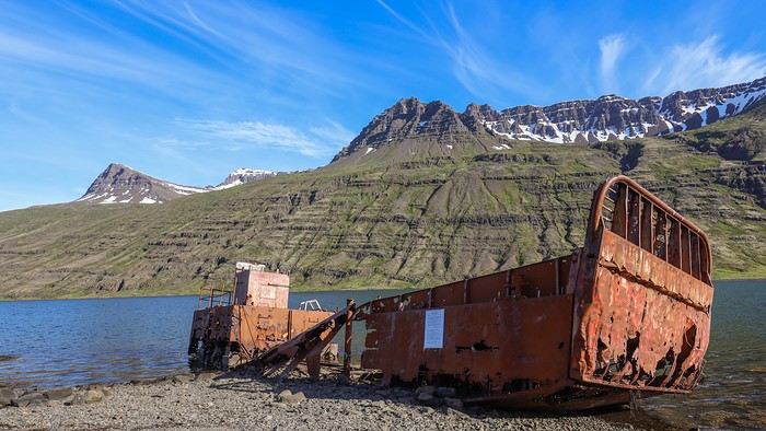
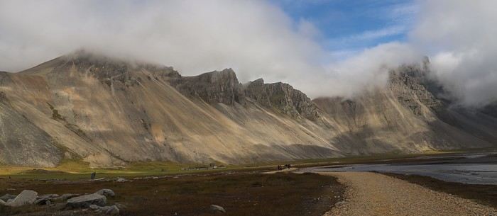
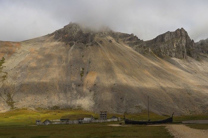
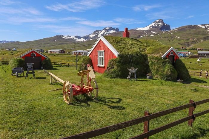
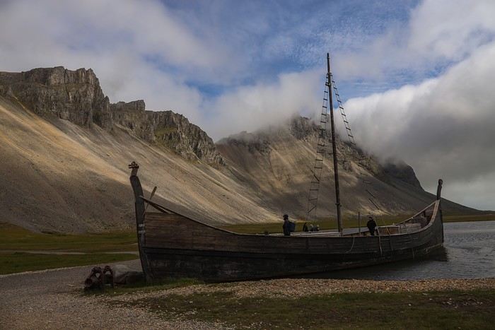
The visit is pretty quick—all the Viking village buildings are, logically, still in great condition.


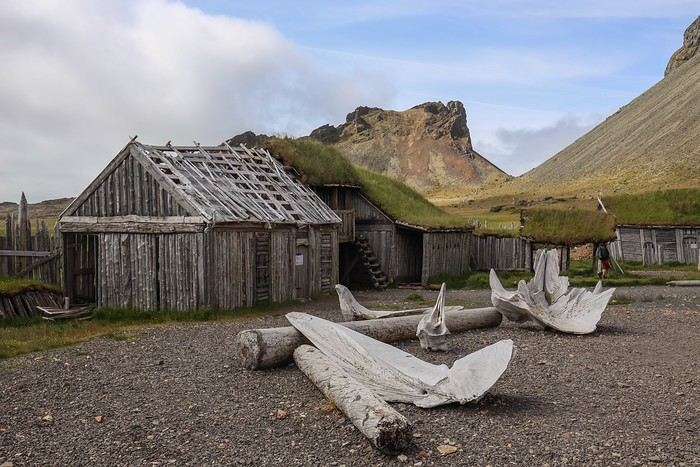
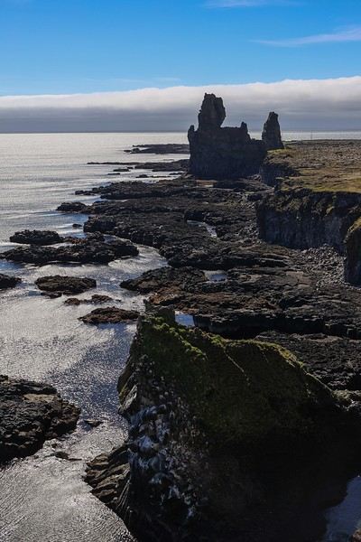
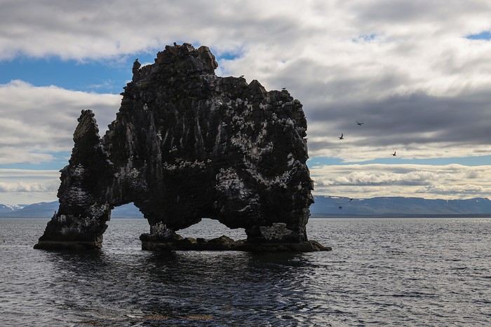
Next, we head toward Stokksnes Beach, one of Iceland’s most beautiful, with its black sand dunes.


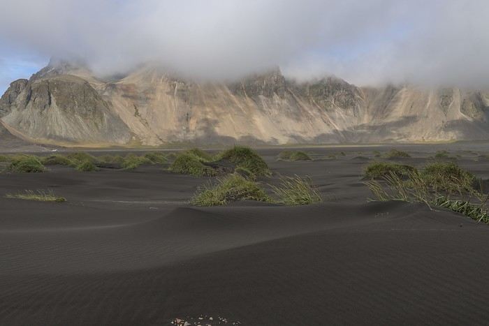
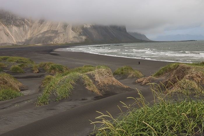
There are several hiking trails that offer different angles of Stokksnes with Vestrahorn Mountain in the background. But the wind is strong and cold, making the walk less enjoyable.
MA
So we continue our journey, always further west, and have a picnic at the foot of the Hoffellsjökull glacier tongue.

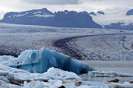
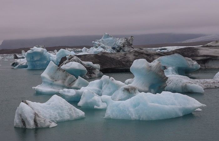
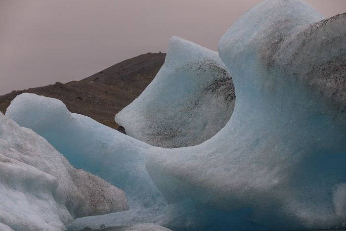
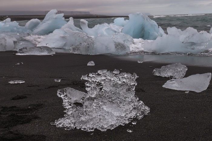
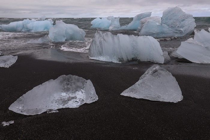
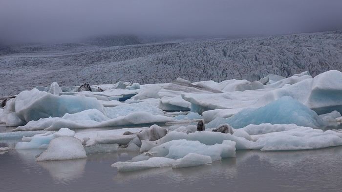
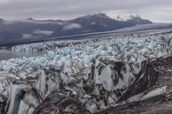
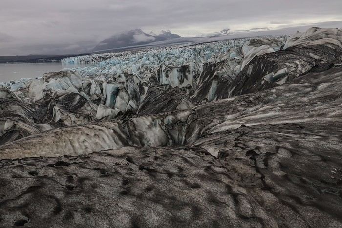
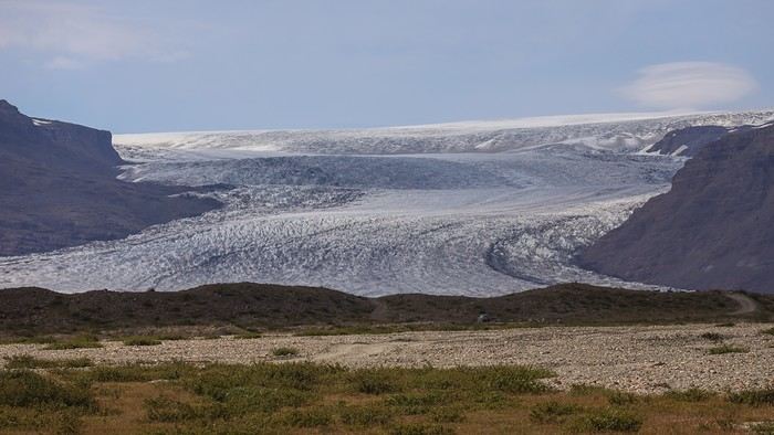
Then, the highlight of the day is Jökulsárlón, a lagoon filled with ice blocks that come from the immense ice cap of the Vatnajökull glacier, moving very slowly in the lagoon.

After 10 days of almost constant sunshine, unfortunately, our luck runs out—the sky is overcast, and the colors aren’t great. After seeing so many photos of Jökulsárlón, I was imagining an incredible number of icebergs, which is far from the case. That’s the downside of spending too much time online preparing the road book. [:/]


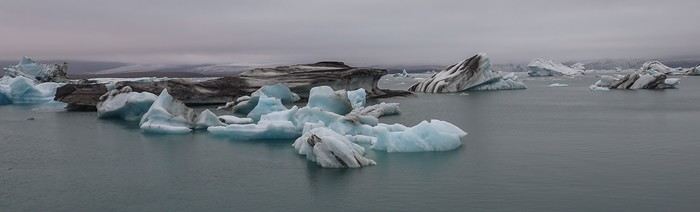
On the other hand, the rest of the family, who’s discovering the site both virtually and in person, is loving it!!

Jökulsárlón is one of the most touristy spots in Iceland and is widely considered the most picturesque landscape in the south of the country. That said, you don’t really feel the crowd once you move a little away from the parking lot.

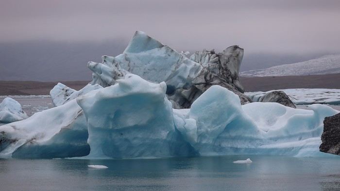
It’s chilly, hats are out, and so is the zoom lens to capture the details of the icebergs floating and inexorably heading toward the sea.


MA
We take the car again to drive 1 km further to the parking lot right next to Diamond Beach.

It's on the right bank of the estuary where large blocks of ice wash ashore, slowly melting and eventually looking (from a distance) like diamonds.

The ice chunks are especially photogenic on the black sand beach.


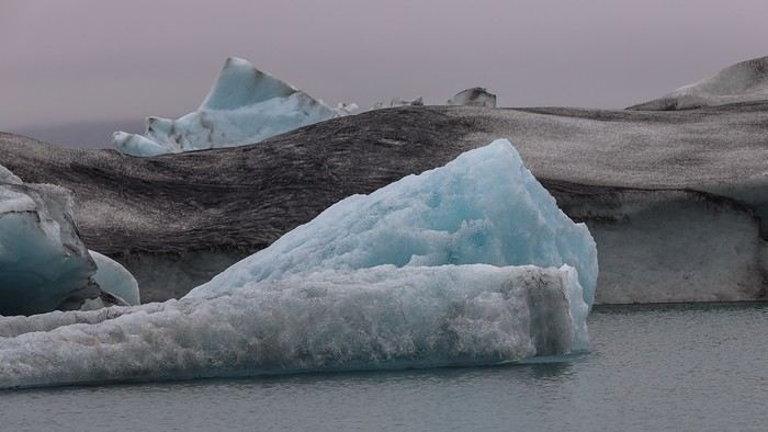
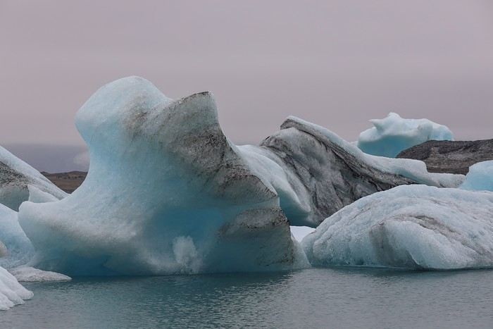
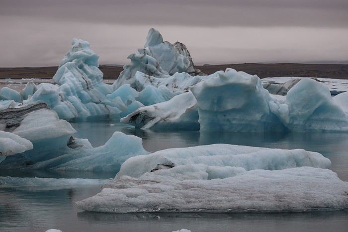
The last stop of the day is Fjallsárlón, another glacial lake about ten kilometers west of Jökulsárlón, and much less crowded than its famous neighbor!

The walk along the lake and its icebergs is a must, as the site exudes tranquility.


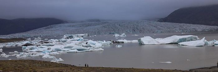
We hit the Ring Road 1 again until we reach the Svinafell campsite, with a complete change in atmosphere and lighting!

We rented a cabin for 4 there, and by letting them know in advance, you can stay with 5 people, provided one of you sacrifices by sleeping on a camping mattress... Since we were too lazy to set up the tent, the main thing for us was to sleep in a solid shelter!


To wrap up this marathon transition day, what better than an excellent burger at Veitingasala, a place that doubles as a gas station, fast-food joint, café, mini-market, and souvenir shop...!
MA
Day 12 - 07/17: Glacier excursion and Svartifoss

Today was the day everyone had been looking forward to, with a glacier excursion on Vatnajökull planned. It’s not cheap, so we decided to use the money Rachel earned from her last internship and Maxime from giving lessons at his stable. No reason they should travel for free...

Joking aside, the day trip costs 165 € per person, with no discount for teens. It might seem like a lot—it *is* expensive—but the excursion lasts 6 hours with Blue Iceland, compared to just 3 hours with the competition for barely less. My math-loving brain tells me that’s an excellent value for money! At least, we’re all hoping so... [:P]

Since the excursion was scheduled from 10 AM to 4 PM, leaving from Jökulsárlón, and we’re always early risers, we had time to visit a glacial tongue, Svinafellsjón, 5 km from the campsite where we rented a cabin.

The scenery is enchanting despite the morning gloom

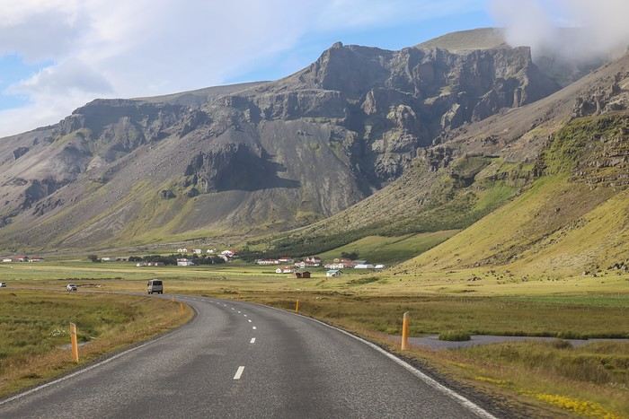
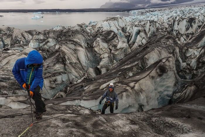
Then, we headed back to Jökulsárlón, the meeting point for our excursion, where the icebergs had shifted quite a bit since the day before.

Definitely worth another photo shoot [;)]!!


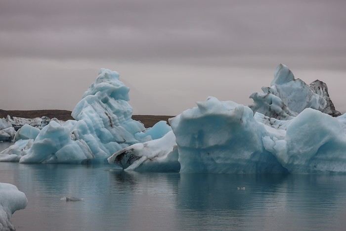
At 9:45 AM, we returned to the parking lot and started looking for a sign from the Blue Iceland tour operator: a truck, a stall, a logo, etc. But we came up empty. We finally asked the other tour operators set up there, and none of them knew who we were talking about...

Eventually, a guy in a huge lifted van asked who we were looking for. When we mentioned our tour operator, he pointed us to a Land Cruiser with a small Blue Iceland logo!

We’d been searching for one of those big lifted minibuses with wheels as tall as Tim, but ended up with a short-chassis Land Cruiser that was barely lifted!!

When our guide arrived, we discovered he was French, and we were the only clients that day. Basically, we got a private tour at the price of a group one—score !!

On the way to the foot of the glacier, Yann, who works for 66°North, taught us all sorts of things about tourism in Iceland... and, of course, how the glacier works.

At the end of the track, he equipped us with helmets, headlamps, and had us test the crampons we’d be wearing later.

After a fifteen-minute walk, Yann stopped at the foot of a crevice and had us descend, roped together, into the ice cave. So much fun!!

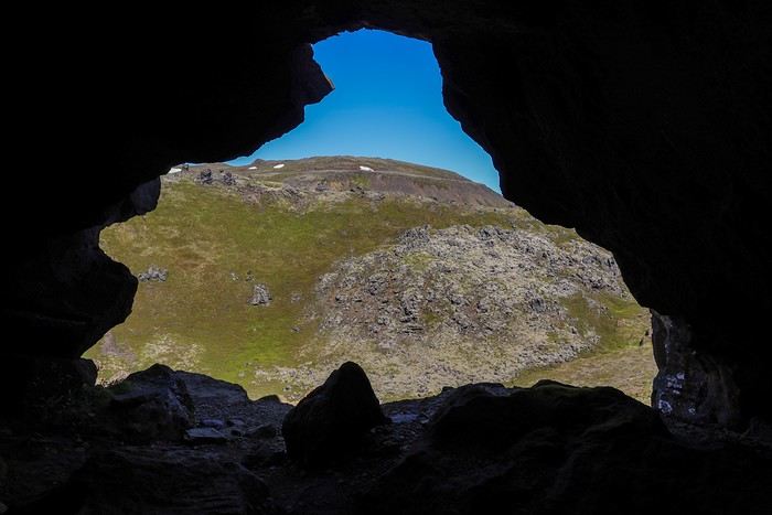
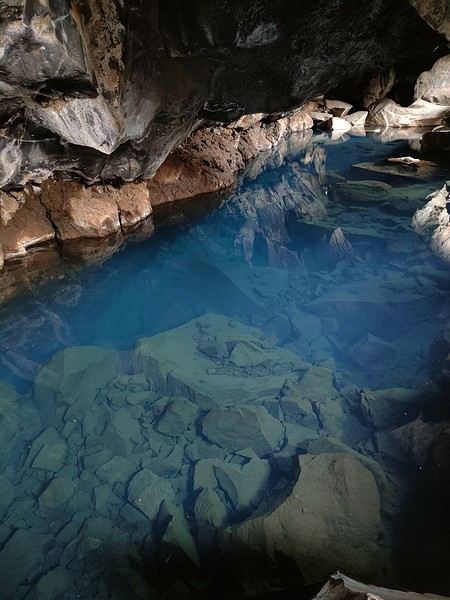
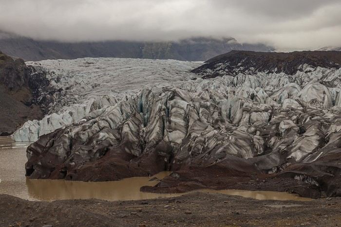
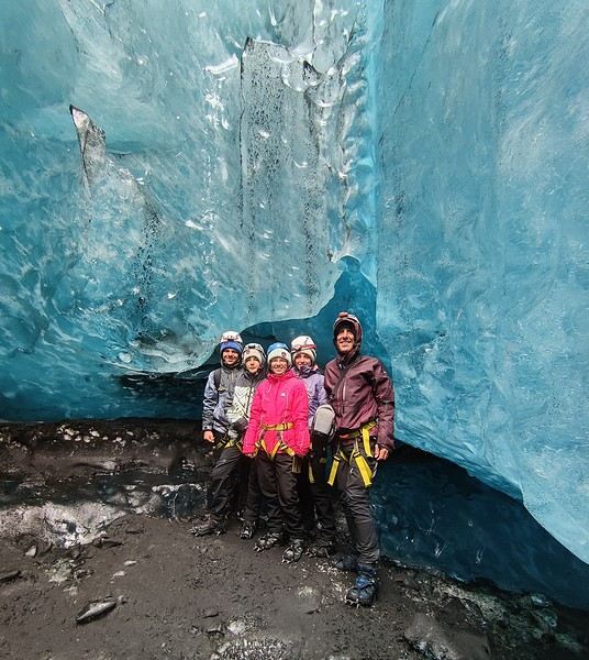
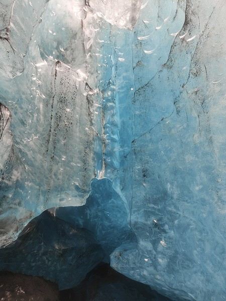
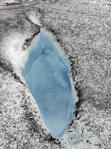
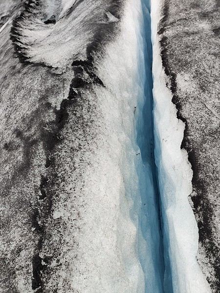
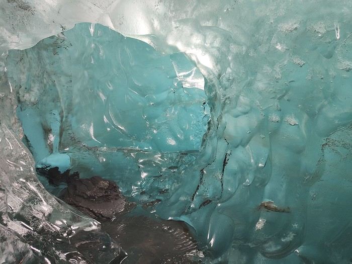
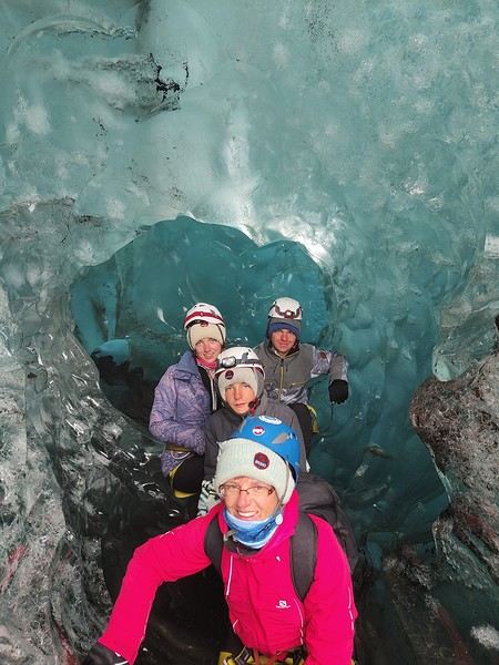
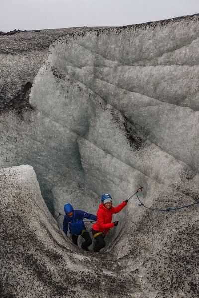
Even though it wasn’t really on the program, we were lucky enough to get to explore an ice cave. It’s melting, of course, but it’s amazing!


Since a big block is likely to fall in the coming days, the guide asked us to steer clear of it and said he wouldn’t take anyone else there for the rest of the summer.

The colors are just magical!!


Yann then led us onto the glacier.

Even though it was raining at first, the colors—a mix of white and basalt—were absolutely stunning, and the atmosphere was mystical!

The movie *Interstellar* was actually filmed on the Svinafellsjökull glacier. It’s easy to imagine being on another planet, and we totally get why this location was chosen...

We learned about how the glacier works—it’s a living, constantly evolving system—and saw moulins


and a little further on, runoff water and small crevasses.

MA
Crevasses and pools


I’m always lagging behind the group—can’t help stopping to capture this experience...


At the very end of the hike, we reach the most spectacular section, just a few hundred meters from where the ice blocks break off. The glacier takes shape with numerous peaks, the crevasses are plentiful and deep, and we have to follow Yann’s path meticulously without straying.

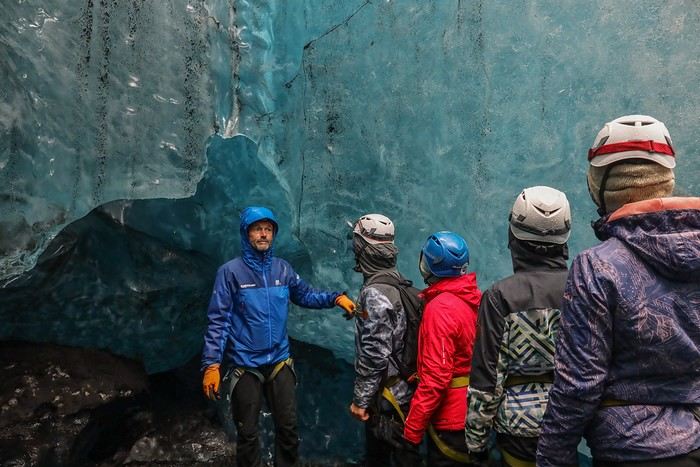
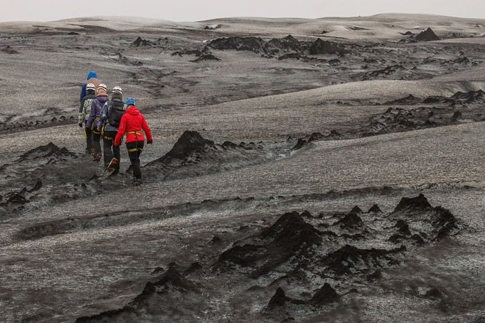
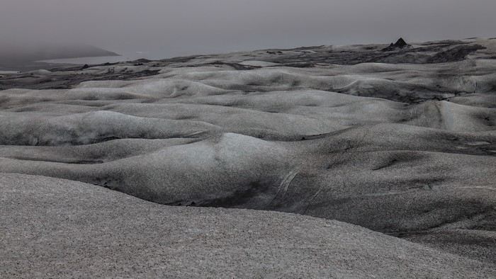
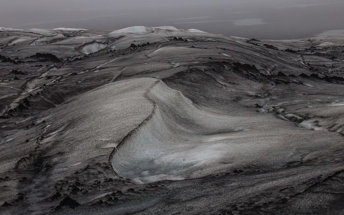
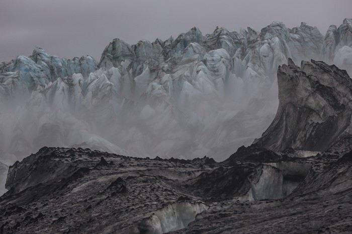
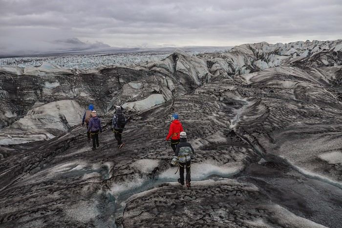
We’re almost at the end with a breathtaking view of the glacier and the ice blocks breaking off into the glacial lagoon of Jökulsárlón. Yann always goes ahead to test the path, validate the route, then comes back to lead us along his tracks...

Afterward, we have a picnic with a five-star view of the glacial lake while Yann prepares the equipment for us to descend and get a closer look at a crevasse.

The sky even clears up for a few minutes, just long enough to capture the magic of a day that will certainly be the highlight of the trip.


Here we go—time to descend while roped up, and each of us gives it a try!


MA
On the way back, since we're walking well, Yann wants to take us to the best viewpoint over the glacier and stumbles upon another improvised ice cave. A little free bonus, as he says.


Then the fog rolls in, adding to the mystical vibe of the place!!

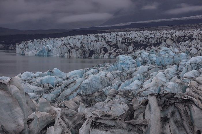
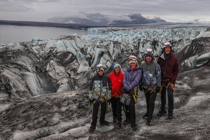
and we make a quick return to the 4x4.

Along the way, we pass several groups of 10-15 people who won’t make it to where we went in just one hour. So, choosing the right excursion makes all the difference... Summer Treasure was ours ;).

Back at the campsite at 5 PM, we split into two groups: the first, with 3 people, chills at the campsite, while the second, with 2 people, decides to do another 4 km hike (200 m elevation gain) to Svartifoss. Since I’m not a snitch, I won’t name names.


To wrap up this unforgettable day, we grab another burger at the same fast-food place as the night before and crash hard at the Svinafell campsite !
BL
This glacier walk was absolutely stunning! And the photos are amazing.
Bluequark

Carnets : Namibie, Laos-Perhentias-BKK, Ouest US, Lanzarote, New-York, Berlin, Cuba, Bardenas Reales, AFS -Lesotho-Swaziland, Japon et le dernier né Colombie: https://voyageforum.com/discussion/ete-2017-trois-semaines-en-colmobie-en-famille-d10108246/
RO
Wow! That day on the glacier was amazing, I’ll keep it in mind for next time 😄 and your photos are awesome 👍
"Voyager est un triple plaisir : l'attente, l'éblouissement et le souvenir." Ilka Chase
KA
I’m freezing but loving all these photos—pretty unusual for travel journals! [;)]

Great job, Marati / Guilhaume! !
Mes photos sur Flickr: https://www.flickr.com/photos/153304262@N05/albums "Le Temps nous égare. Le Temps nous étreint. Le Temps nous est gare. Le Temps nous est train".
GI
Hi Guillaume, The glacier excursion is really nice! I also wanted to congratulate you on the gorgeous photos in your travel journal—they’re absolutely stunning! 😎
Nathalie

Photos et carnets de voyage : http://www.girardinphoto.net
MA
Thanks Bluequark, Isabelle, and Nathalie for your compliments and encouragement [:)]!

Welcome Kate, Thank you for your kind words [:)]

You’ve got to admit, it’s hard to take a bad photo with a backdrop as stunning as this glacier gave us [;)] !

You might also like