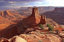
UTAH - BRYCE CANYON NATIONAL PARK - SCENIC DRIVE
GPS Coordinates: 37.64037, -112.16963 Visitor Center
Highway 63 is a scenic road that runs through Bryce Canyon National Park from north to south. It provides access to 14 viewpoints, each more stunning than the last.
A brochure is actually handed out when you enter the park. It lists the locations of all the viewpoints along this road.
It’s safe to say that Bryce Canyon is truly unique and unlike any other park in the American West. In fact, it’s one of the most beautiful parks we’ve visited in the United States.
The drive along this road takes you to the most photogenic viewpoints and gives you a sense of what Bryce Canyon has to offer without having to tackle hikes that can be tough due to the high altitude and semi-arid climate.
https://youtu.be/M7W6CrW0ss8
USA 2022 Road Trip
by Pinacoladada
Translated into English.
Anne
Blogue: https://deuxnomades.blogspot.com/
YouTube: https://www.youtube.com/c/SouthAngelVideo?sub_confirmation=1
UTAH - ZION NATIONAL PARK - PA'RUS TRAIL
GPS coordinates: 37.20183, -112.98678 Start of the trail GPS coordinates: 37.21830, -112.97401 End of the trail
This 2.8 km (one-way) paved trail starts at the South Campground, just north of the Visitor Center. It runs along the Virgin River in the lower part of the canyon and ends at Canyon Junction.
It’s the only trail in Zion National Park that allows pets (on a leash), bikes, and is also one of the few trails in the park accessible by wheelchair.
The trail is easy to walk and the scenery is really pleasant. The towering cliffs around us are beautifully colored, and the vegetation is lush.
We crossed several bridges overlooking the river, which is quite pretty.
We even had the surprise of encountering a snake that quickly crossed the trail. We took the time to observe it from a safe distance.
We also spotted a mule deer wandering near the campground.
https://youtu.be/WRRP29qS00o
Anne
Blogue: https://deuxnomades.blogspot.com/
YouTube: https://www.youtube.com/c/SouthAngelVideo?sub_confirmation=1
UTAH - ZION NATIONAL PARK - SAND BENCH TRAIL
GPS Coordinates: 37.23700, -112.96110 Trailhead GPS Coordinates: 37.23738, -112.96348 Waterfalls GPS Coordinates: 37.23869, -112.96406 End of the hike
Sand Bench Trail is a loop trail of about 6 kilometers (3.7 miles) that starts near the Court of the Patriarchs stop. Just take the access road leading to a large water reservoir and the pedestrian bridge over the Virgin River.
The trail first heads west to offer a great view of the Court of the Patriarchs, then turns south, crosses a small stream, and climbs to the top of the rockslide. The total elevation gain to the summit is about 150 meters (490 feet).
For our part, we decided to only do a very short section of this trail. In fact, we covered a total distance of 1.2 km (0.75 miles) round-trip, which still allowed us to see some pretty little waterfalls cascading into the Virgin River and stunning rock formations that Zion is famous for.
The trail is sandy and quite hot and exposed. It’s best to hike it during the cooler months or on a cloudy day to avoid heat exhaustion.
https://youtu.be/Dv1kK_ADkpM
Anne
Blogue: https://deuxnomades.blogspot.com/
YouTube: https://www.youtube.com/c/SouthAngelVideo?sub_confirmation=1
UTAH - ZION NATIONAL PARK - EMERALD POOLS TRAIL
GPS coordinates: 37.25096, -112.95806 Trailhead GPS coordinates: 37.25096, -112.95806 Lower Emerald Pool GPS coordinates: 37.25734, -112.96630 Upper Emerald Pool GPS coordinates: 37.25713, -112.96299 Middle Emerald Pool
Emerald Pools Trail is one of Zion National Park’s iconic hikes. This trail forms a 4-kilometer loop and is packed with incredible viewpoints and breathtaking landscapes along the way.
The main highlights of this hike include water pools and waterfalls.
The trailhead is located in front of Zion Lodge, across the main road. The trail is easy to navigate. However, there’s a 60-meter elevation gain to reach Middle Emerald Pool and another 60-meter gain to reach Upper Emerald Pool.
Keep this in mind if you’re hiking during the summer months, as it can get very hot, making the hike more challenging and exhausting.
Lower Emerald Pool
Lower Emerald Pool is about 1 km from the trailhead. This section of the trail is very easy to walk.
In this area, the vegetation is lush, and the trail leads to a large alcove from the top of which two waterfalls flow into small pools.
When we passed through, the water flow was low. However, the natural scenery is really pretty in this section.
Upper Emerald Pool
Once past the alcove, the trail climbs and becomes more difficult. Steps carved into the rock lead us to the top of the cliff, offering nice viewpoints of the surrounding cliffs.
Upper Emerald Pool is surrounded by the walls of a tall red sandstone cliff, partially covered in ivy. It’s also shaded, allowing us to relax and enjoy a break while admiring the truly enchanting scenery.
The temptation to swim is strong after hiking under the hot sun, but swimming is strictly prohibited here.
Middle Emerald Pool
After taking a break at Upper Emerald Pool, we backtracked and turned right onto the trail leading to Middle Emerald Pool.
This section is also very beautiful, and hikers take the opportunity to rest on the rocks along the stream.
The Return
The trail is steep in some places, and there are no protective barriers. So, be careful with children.
The views are truly stunning, including the one overlooking Lower Emerald Pool below the trail.
The viewpoints of the Virgin River and the surrounding cliffs are also amazing.
https://youtu.be/7-3qcWwJxkc
Anne
Blogue: https://deuxnomades.blogspot.com/
YouTube: https://www.youtube.com/c/SouthAngelVideo?sub_confirmation=1
UTAH - ZION NATIONAL PARK - WEST RIM TRAIL (TRAIL CONNECTING TO ANGELS LANDING)
GPS coordinates: 37.25927, -112.95139 Trailhead GPS coordinates: 37.26110, -112.95070 Scenic viewpoint and turnaround (+/- 500 m round trip)
Angels Landing is one of Zion’s summits and one of the park’s most popular hikes. It rises over 450 meters above the canyon floor and offers a stunning 360-degree view of the canyon.
A permit is now required to hike this trail, which is rated difficult due to its steep elevation gain and very narrow sections.
Since we didn’t have a permit for this hike, we only covered a tiny section of the trail to get a glimpse of the scenery in this area.
The trail starts on the other side of the main road at stop #6, The Grotto. You’ll need to cross the pedestrian bridge over the Virgin River and then turn right onto the West Rim Trail, which leads to the Angels Landing trail.
The beginning of the trail is easy to walk and offers lovely views of the Virgin River winding through the valley at the base of this magnificent canyon.
https://youtu.be/VCRwqKs68GE
Anne
Blogue: https://deuxnomades.blogspot.com/
YouTube: https://www.youtube.com/c/SouthAngelVideo?sub_confirmation=1
UTAH - ZION NATIONAL PARK - RIVERSIDE WALK
GPS coordinates: 37.28521, -112.94774 Trailhead GPS coordinates: 37.29675, -112.94828 End of the trail
The last stop in Zion National Park is the Temple of Sinawava. It's one of the most popular spots in the park because this is where the Riverside Walk begins—a 3-kilometer (round-trip) hiking trail that leads to The Narrows, a narrow canyon with towering sandstone walls through which the Virgin River flows.
Riverside Walk is a really pretty, easy, and family-friendly stroll that follows the Virgin River. The farther you go, the closer the canyon walls get. The scenery is absolutely stunning.
Along the way, you can see hanging gardens, desert wetlands, wildlife by the river, and small waterfalls.
There are also several spots along the river to take a break if you need one.
Riverside Walk ends at a patio with stone steps leading down to the river.
This is where The Narrows hike begins. You’ll need to be well-prepared because most of the hike takes place in the Virgin River’s riverbed. The rocks can be slippery, and the water is very cold. Sometimes, the water level can be quite high.
It’s essential to check the weather and the risk of flash flooding before heading into the depths of this canyon.
https://youtu.be/rzybGpehWT4
Anne
Blogue: https://deuxnomades.blogspot.com/
YouTube: https://www.youtube.com/c/SouthAngelVideo?sub_confirmation=1
UTAH - ZION NATIONAL PARK - COURT OF THE PATRIARCHS & BIG BEND
GPS Coordinates: 37.23729, -112.96064 Court of the Patriarchs GPS Coordinates: 37.27270, -112.94655 Big Bend
Court of the Patriarchs is considered the shortest trail in Zion National Park. To get there, just take the shuttle and get off at the 4th stop.
The trail starts at the shuttle stop. It’s paved and quickly leads to a small viewpoint overlooking a cluster of sandstone cliffs named Court of the Patriarchs.
The three peaks you see are named after the biblical figures Abraham, Isaac, and Jacob. You can also spot two other rock formations known as Mount Moroni and The Sentinel.
Big Bend is the seventh shuttle stop. There’s no trail here, but it’s a super popular spot for photos since you get an amazing view of the canyon, especially Great White Throne with Angels Landing in the foreground.
You might even spot condors in this area.
https://youtu.be/lv8ZT-57TfQ
Anne
Blogue: https://deuxnomades.blogspot.com/
YouTube: https://www.youtube.com/c/SouthAngelVideo?sub_confirmation=1
UTAH - ZION NATIONAL PARK - MOUNT CARMEL HIGHWAY SCENIC DRIVE
The Zion-Mount Carmel Highway, also known as Utah State Route 9, is a scenic road that connects the east entrance of Zion National Park to the village of Springdale.
Unlike the Zion Scenic Drive, it’s open year-round, and personal vehicles are allowed.
This road is a series of switchbacks winding through the canyon at elevations ranging from 1,130 to 2,700 meters. Several overlooks along the way offer stunning views of the canyon.
Over millions of years, water, wind, and ice have shaped this canyon, creating an extraordinary landscape.
https://youtu.be/POwCUSWpnqA
Anne
Blogue: https://deuxnomades.blogspot.com/
YouTube: https://www.youtube.com/c/SouthAngelVideo?sub_confirmation=1
UTAH - KANAB - JACKSON FLAT RESERVOIR
GPS coordinates: 37.007388, -112.516543
While in the Kanab area, we were looking for a spot to relax by the water, and after some searching, we found Jackson Flat Reservoir.
This desert oasis, located about 6 km from downtown Kanab, is the perfect spot for outdoor enthusiasts—and it’s free!
You’ll find a boat ramp, a lovely sandy beach, a volleyball court, and workout stations.
The facilities include restrooms and an outdoor shower.
There are plenty of activities to enjoy here. The calm, clear waters of the reservoir are ideal for water sports like canoeing, kayaking, or paddleboarding.
There’s a paved trail, the Sherry Belle Trail, which loops 5 km around the reservoir. You can walk, run, bike, or even rollerblade on it.
It’s also a great spot for birdwatching—you’ll see waterfowl and many other bird species, as well as frogs, lizards, and even snakes.
https://youtu.be/Y66gmPryOyE
Anne
Blogue: https://deuxnomades.blogspot.com/
YouTube: https://www.youtube.com/c/SouthAngelVideo?sub_confirmation=1
UTAH - TOADSTOOLS TRAIL IN GRAND STAIRCASE-ESCALANTE NATIONAL MONUMENT
GPS Coordinates: 37.10125, -111.87330 Parking and trailhead
Located in the Grand Staircase-Escalante National Monument in Utah, the Toadstools Trail, a 2.9-kilometer (1.8-mile) round-trip hike, is perfect for exploration. It’s found along Highway 89 between Page and Kanab.
Actually, the Toadstools are rock formations that strangely resemble mushrooms, and several can be found in this area.
The cap on top of these formations is what sets them apart from other, more common chimney-shaped rocks.
These unique formations are created by Dakota sandstone rocks perched atop Entrada sandstone bases. As the softer Entrada sandstone erodes, the Dakota sandstone forms a cap, like a mushroom, on top.
We can also see Wahweap Hoodoos, which are very similar but have different colors. Their bodies are white while their caps are brown, unlike the Toadstools, which have reddish hues.
To get up close to these famous rock formations, just take the trail starting near the parking area and head north, following a dry riverbed (wash) that winds through a beautiful little canyon.
After leaving the canyon, you enter a valley where these famous rock formations are located. You can even see them up close—they come in different shapes, sizes, and colors.
You might even spot some perched atop the cliffs.
While exploring the park, we discovered a slot canyon passage in the cliff. We ventured inside and felt so small surrounded by walls towering to dizzying heights.
https://youtu.be/4ByrIaB1QUI
Anne
Blogue: https://deuxnomades.blogspot.com/
YouTube: https://www.youtube.com/c/SouthAngelVideo?sub_confirmation=1
UTAH - PAGE - GLEN CANYON DAM OVERLOOK
GPS coordinates: 36.92385, -111.47716 Glen Canyon Dam Overlook GPS coordinates: 36.93570, -111.48552 Glen Canyon Dam Visitor Center
This very short trail (+/- 300 meters round trip) starts near the parking lot. It consists largely of uneven rocky steps. However, a metal handrail is in place to make getting around easier.
It leads to a viewpoint located at the edge of the canyon above the Colorado River, offering a stunning view of the river, the canyon, and the Glen Canyon Dam.
Afterward, we headed to the Glen Canyon Visitor Center and took a walk in the area, as well as on the pedestrian section of the bridge that spans the Colorado River, to get other magnificent views of the canyon.
The Glen Canyon Dam, completed in 1964, was built to hold back the waters of the Colorado River to generate electricity, store water for the arid southwestern United States, and create the vast Lake Powell, a popular recreational area along the Utah-Arizona border.
It took 17 years for Lake Powell to fill completely. It is the second-largest artificial reservoir in the United States.
https://youtu.be/B885idLo1NQ
Anne
Blogue: https://deuxnomades.blogspot.com/
YouTube: https://www.youtube.com/c/SouthAngelVideo?sub_confirmation=1
UTAH - PAGE - GLEN CANYON NATIONAL RECREATION AREA
GPS coordinates: 36.93561, -111.48584 Carl Hayden Visitor Center GPS coordinates: 36.94299, -111.49347 Entrance via Lake Shore Dr GPS coordinates: 36.98900, -111.51600 Entrance via Wahweap Blvd GPS coordinates: 36.96890, -111.49900 Wahweap Overlook
Glen Canyon is located in southern Utah, with a small part of the park also extending into northern Arizona. Its main entrance in Arizona is in Page.
Here you’ll find Lake Powell, which was created by the Glen Canyon Dam on the Colorado River.
Wahweap Bay, accessible by car, is the first bay of Lake Powell and the most visited bay on the lake—not only because of its proximity to the Glen Canyon Dam, but also due to its facilities and its location near the town of Page.
The road through this part of the park offers several viewpoints over Lake Powell, as well as the colorful landscape and majestic rock formations surrounding it.
Lake Powell is a true oasis of coolness in this vast rocky desert. The lake’s waters are very calm, perfect for swimming and water sports.
The Wahweap Marina is a year-round complex that includes a hotel, the Lake Powell Resort, campgrounds, and a variety of restaurants.
You can also rent jet skis and pleasure boats or book a guided boat tour.
Lone Rock is another area of Wahweap Bay. It’s accessible via a road called Lone Rock Rd.
The name refers to the solitary rock that rises to 1,230 meters in the bay. The scenery here is truly stunning.
There are also campgrounds that don’t require reservations, though there are additional fees on top of the entrance fees.
Wild camping is done on a sandy beach or in the dunes. There are no designated sites.
Caution is advised when driving in this area, as the road is sandy. We even saw a car get stuck in the sand.
Additionally, during our visit, we experienced strong winds that blew sand around, significantly reducing visibility. The road was difficult to follow in those conditions.
We also went to Wahweap Overlook. You can drive there. This viewpoint, located at the top of a hill, offers a beautiful panoramic view of the bay and the marina on the stunning Lake Powell.
If you’d like more information about this park, I invite you to visit this website: https://www.nps.gov/glca/index.htm
https://youtu.be/DxZkXAqeE6k
Anne
Blogue: https://deuxnomades.blogspot.com/
YouTube: https://www.youtube.com/c/SouthAngelVideo?sub_confirmation=1
ARIZONA - PAGE - HORSESHOE BEND OVERLOOK
GPS Coordinates: 36.87646, -111.50283 Parking
Horseshoe Bend is a horseshoe-shaped incised meander of the Colorado River. A short and easy walk of about 1.5 miles (2.4 km) round-trip from the parking lot leads to the stunning overlook that towers above the canyon.
This viewpoint lets you admire the Colorado River, with its crystal-clear emerald-green waters, surrounded by towering cliffs in warm orange hues. The scenery is simply enchanting.
If you're visiting Page, this is a must-see!
However, keep in mind that this trail offers almost no shade. There are only two shaded structures along the path, but none at the overlook itself.
Even over such a short distance, the heat can be exhausting. Please come prepared.
The overlook is fenced for safety reasons. You can move to the edge of the cliff on either side of the fenced area to get different views of Horseshoe Bend. That said, be cautious—the sandstone cliffs can be unstable, and the wind can be very strong.
The tiny boats you see on the water really put into perspective just how deep this incredible canyon is.
This popular site has a well-maintained, secure parking area, including spaces for larger RVs.
https://youtu.be/l3z_vVEH0dg
Anne
Blogue: https://deuxnomades.blogspot.com/
YouTube: https://www.youtube.com/c/SouthAngelVideo?sub_confirmation=1
ARIZONA - PAGE - UPPER ANTELOPE CANYON
GPS Coordinates: 36.91807, -111.45952 Check-in at Chief Tsosie Trading Post
Antelope Canyon consists of two slot canyons: Upper Antelope, which is easy to access, and Lower Antelope, which I’d describe as a bit more adventurous.
It’s not possible to visit Antelope Canyon without a guided tour. The tour lasts about 1 hour. Additionally, during our visit, masks were mandatory on the Navajo Reservation.
We booked the guided tour to Upper Antelope Canyon online and checked in at the Chief Tsosie Trading Post located on Lake Powell Blvd in Page.
From there, we boarded a very comfortable, air-conditioned van and headed toward the canyon. The ride took about 20 minutes.
Once we arrived, we followed our guide through the slot canyon, and she showed us the different points of interest. Some rock formations, depending on the light, resemble a rose, a flame, or even a bear.
She even offered to take several photos of each group member and helped us capture great shots of the site. We were really happy with her service.
Upper Antelope Canyon is truly a unique place, especially when the sun’s rays filter into the canyon and illuminate the smooth sandstone walls with their spectacular ripples.
From the outside, nothing suggests that stepping into a narrow opening in the cliff would lead to a deep, winding corridor taking us through several large sandstone chambers. The height of the sandstone walls is truly impressive.
When you see photos of Upper Antelope Canyon, you appreciate the site’s incredible beauty, but when you get the chance to experience it in person, you also feel the serenity it exudes. It’s a pure moment of happiness.
After the tour, we exited the slot canyon and had to climb ramps and stairs to return to our starting point where the van was parked.
The temperature inside the slot canyon is comfortable, but outside, the heat can be overwhelming. That’s why it’s important to bring plenty of water.
https://youtu.be/aMn-NpN2z1I
Anne
Blogue: https://deuxnomades.blogspot.com/
YouTube: https://www.youtube.com/c/SouthAngelVideo?sub_confirmation=1
ARIZONA - PAGE - NAVAJO CANYON BOAT TOUR AT LAKE POWELL
GPS coordinates: 36.96183, -111.43249 Antelope Point Marina
After a few unsuccessful attempts, we finally managed to book a boat tour on Lake Powell in Navajo Canyon.
The tour departs from Antelope Point Marina, located in the Glen Canyon National Recreation Area. There’s a fee to enter the park.
We left our vehicle in the Visitor Center parking lot and took a golf cart to the marina.
From there, we boarded a houseboat and set off for a two-hour cruise on the calm waters of Lake Powell in the Navajo Canyon area.
The sandstone cliffs, rising 183 meters around us, are truly impressive. They have different shapes and layers of color. Erosion has created a stunning landscape.
It’s great to see these rocks from water level.
Some of the cliff walls are covered with a black layer due to manganese oxides. This layer is called desert varnish or Navajo tapestry.
https://youtu.be/aZXwXnGkewc
Anne
Blogue: https://deuxnomades.blogspot.com/
YouTube: https://www.youtube.com/c/SouthAngelVideo?sub_confirmation=1
ARIZONA - PAGE - ANTELOPE CANYON X
GPS coordinates: 36.82016, -111.30767
Canyon X consists of two slot canyons and is located about 19 kilometers east of the town of Page, Arizona, specifically on Highway 98 at mile marker 307.8.
It’s actually in the same canyon as the famous Upper Antelope Canyon and Lower Antelope Canyon.
Tours are only offered by one operator, Taadidiin Tours, which specializes in small groups to provide an exclusive and memorable experience.
Booking isn’t mandatory, but it’s recommended due to limited spots, and we need to arrive 30 minutes before our tour time.
We use our own vehicle to get to the canyon. The vehicles, lined up in a convoy, follow a lead vehicle along a dusty dirt road.
Once there, we have to descend several staircases to reach the entrance of the first slot canyon.
By definition, a slot canyon starts as a narrow crack in the rock. Over millions of years, rainwater and floods have widened and deepened this opening, creating a tall, narrow passage between the plateau’s rocks, sometimes stretching for several kilometers.
With our guide, we enter the first section of Canyon X and discover the same towering walls as those in Upper Antelope Canyon, which we visited the day before.
Erosion has shaped stunning rock formations whose colors shift with the light. It’s truly breathtaking. Canyon X is every bit as impressive as Upper and Lower Antelope Canyon.
We retrace our steps along the same trail, with the guide sharing details about the different rock formations.
Afterward, we take a short hike through a dry riverbed to reach the entrance of the second slot canyon. This one has an X-shaped opening at the top, which is how it got its name.
The rock formations are just as spectacular in this second part of the canyon, and the light filtering in makes them even more striking. The scenery is mesmerizing.
The orange sand underfoot is incredibly fine. We saw this when our guide tossed some sand against the cliff walls, and it cascaded down slowly like a waterfall. It was a beautiful sight.
After the tour, we took the same route back to the parking lot. Bring water—the heat can be overwhelming here.
We really enjoyed the visit and had an excellent guide who didn’t hesitate to share valuable tips for taking photos in this stunning canyon.
https://youtu.be/OohQdshGoWA
Anne
Blogue: https://deuxnomades.blogspot.com/
YouTube: https://www.youtube.com/c/SouthAngelVideo?sub_confirmation=1
ARIZONA - CANYON DE CHELLY NATIONAL MONUMENT - CHELLY CANYON
Chelly Canyon - South Rim
The scenic drive (South Rim Dr Hwy, also known as Indian Route 7) starts at the Visitor Center and ends at Spider Rock, covering a total of about 59 km round trip.
Here are the various viewpoints you can see along the way.
Tunnel Overlook
This first viewpoint is a small side canyon filled with rocks, offering a partial view of the main gorge, which is shallow at this spot.
The trail to get there is very short and starts on the right side of the parking lot. When we were there, the wind was so strong that we stayed near the parking lot to admire the scenery.
If you want to go beyond this viewpoint to explore the canyon, you’ll need to hire a certified guide.
Tseyi (Tsegi) Overlook
Tseyi Overlook offers a stunning view of the canyon, the Navajo farmlands, and the rock formation called Blade Rock, at the base of which lies Chinle Wash.
Junction Overlook
Junction Overlook lives up to its name as it overlooks the confluence of Canyon del Muerto and Canyon de Chelly, providing beautiful views of the Chinle Valley.
Here, with binoculars or the powerful zoom on your camera, you can spot Anasazi ruins.
White House Overlook
White House Overlook, located 100 meters from the parking lot, is a viewpoint where you can see the ruins of the White House, which date back over 1,000 years. With its 80 rooms, it’s one of the largest ruins in the canyon.
The black streaks on the sandstone walls above the White House ruins are called desert varnish. These streaks are formed by water seeping in and reacting with the iron in the sandstone.
A 4-kilometer round-trip trail starts at this viewpoint, descending into the canyon and leading right below the White House ruins.
This is the only trail allowed to be hiked in this park. When we visited, it was closed for safety reasons.
The viewpoint also offers a great view of the canyon and some large buttes upstream.
Sliding House Overlook
Sliding House Overlook is located on a side road. From the parking lot, you’ll need to walk 200 meters to reach the viewpoint. Signs point the way.
Actually, there are two different viewpoints here. The first offers a view of the canyon toward Antelope Point. The rock formations are spectacular at this spot.
The second viewpoint is a short distance from the first. You can see the ruins of a dwelling (Sliding House) built on a precarious slope, which caused much of the cliffside to slide.
The ruin gets its name from the unstable slope it was built on, which eventually caused most of the cliffside to slide. If you zoom in on the photo, you can see pictographs painted on the cliff, likely made from the roofs of rooms that are no longer there.
Face Rock Overlook
Face Rock Overlook is located on the access road leading to Spider Rock Overlook.
The trail to this viewpoint is paved and wheelchair-accessible. It offers a beautiful view of the canyon.
Observation tubes have been installed to help spot certain attractions.
You can see ruins located in different spots, some of which were built in hard-to-reach places.
Spider Rock Overlook
A 7.2-kilometer access road leads to Spider Rock Overlook.
The trail starts near the parking lot and is paved up to the first viewpoint, which overlooks Canyon de Chelly and the monolith called Spider Rock.
According to Navajo mythology, Spider Rock is the home of Spider Woman, a deity who taught the people how to weave.
There are also a few spotting tubes at the start of the trail to help locate the ruins in the canyon.
There’s another viewpoint 125 meters from the first, but it’s not paved, and the terrain is quite rough. From here, you can see other ruins tucked into small alcoves.
https://youtu.be/KrKc4I_179g
Anne
Blogue: https://deuxnomades.blogspot.com/
YouTube: https://www.youtube.com/c/SouthAngelVideo?sub_confirmation=1
ARIZONA - CANYON DE CHELLY NATIONAL MONUMENT - CANYON DEL MUERTO
* North Rim - Canyon del Muerto
The north rim is accessible via Indian Route 64, which stretches about thirty kilometers from the Visitor Center to Massacre Cave Overlook.
This part of the canyon is much less crowded than the south rim. However, the various overlooks along this route offer breathtaking views of the canyon.
Here are the different viewpoints you can see on the north rim of the canyon.
** Ledge Ruin Overlook
GPS Coordinates: 36.16260, -109.46550
The first overlook on the north rim was once Ledge Ruin, but it has been closed for many years due to safety reasons.
** Antelope House Overlook
GPS Coordinates: 36.15841, -109.44022 Parking GPS Coordinates: 36.15593, -109.44075 Antelope House Overlook
From the parking area, the trail loops around for about 700 meters, offering a wide viewpoint where the ruins of Antelope House, built by the Ancestral Puebloans (Anasazis), and other smaller sites can be seen in the canyon below.
Antelope House gets its name from the antelope paintings found on a nearby cliff wall, which date back to the 1830s.
As you continue toward the second overlook, you’ll see a large sandstone island at the junction of Del Muerto and Black Rock Canyons, known as the Navajo Fortress.
This short hike in the area reveals a grand and colorful landscape. Erosion has created numerous alcoves and stunning arches in the cliffs.
** Mummy Cave Overlook
GPS Coordinates: 36.22859, -109.36123
Mummy Cave, with over 80 rooms and three kivas, is the largest Ancestral Puebloan village preserved in Canyon de Chelly.
Located more than 90 meters above the valley floor, it looks like a miniature village clinging to the cliffs.
The Navajo call this place "Tseyaa Kini," meaning "the house under the rock."
Below the ruins, two mummies were reportedly found in funeral urns in 1880, which led archaeologists to name the site "Mummy Cave."
Archaeological evidence indicates that this giant amphitheater, made up of two caves, was occupied from 300 to 1300 AD. The central structure between the two caves includes a three-story building.
** Massacre Cave Overlook
There are three overlooks at this spot. The first two are wheelchair-accessible, while the third is more primitive.
The first overlook, Massacre Cave Overlook, is the site of a cave where, in 1805, a Navajo tribe took refuge during a battle against a Spanish military expedition led by Lieutenant Antonio Narbona.
The location was difficult to access from below but highly visible from the canyon rim. As a result, after just one day of fighting, over 110 people from the tribe were killed.
The second overlook overlooks Canyon del Muerto, and you can also see the third overlook along the rim below.
The third overlook offers a nice viewpoint of alcoves that house the ruins of Yucca Cave and a granary.
https://youtu.be/8fM9uA01MKA
Anne
Blogue: https://deuxnomades.blogspot.com/
YouTube: https://www.youtube.com/c/SouthAngelVideo?sub_confirmation=1
ARIZONA - MONUMENT VALLEY NAVAJO TRIBAL PARK
GPS coordinates: 36.98216, -110.11186 Visitor Center
Monument Valley is a legendary natural site located on the border between Arizona and Utah in the United States. It’s home to the Navajo people, who live off agriculture, sheep farming, and selling handmade crafts.
The Valley Drive, a 27-kilometer dirt road, loops through the park and lets you see many truly spectacular rock formations.
* The Mittens and Merrick Butte
GPS coordinates: 36.98045, -110.10374 East & West Mitten Overlook GPS coordinates: 36.97667, -110.09706 Merrick Butte
These are the most famous rocks in Monument Valley. The best viewpoint for these formations is from the Visitor Center terrace.
* Elephant Butte
GPS coordinates: 36.9685, -110.0896
Elephant Butte, as the name suggests, looks like an elephant.
* Three Sisters
GPS coordinates: 36.96038, -110.08722
On the way to John Ford's Point, you’ll see three tall rock spires called the Three Sisters.
* Camel Butte
GPS coordinates: 36.95145, -110.08272 Parking GPS coordinates: 36.95282, -110.07654 Camel
Camel Butte, as the name suggests, looks like a camel.
* John Ford's Point
GPS coordinates: 36.95350, -110.08747 Parking GPS coordinates: 36.95441, -110.08737 John Ford Point
This spot is dedicated to the work of John Ford, who used Monument Valley as a backdrop for several of his Western films. Many other directors, including Sergio Leone, have also filmed here.
* The Hub Point
GPS coordinates: 36.93590, -110.07834
The Hub is a unique 45-meter-high rock formation. At its base, you’ll find Navajo dwellings.
* Bird Spring
GPS coordinates: 36.93644, -110.06139
Bird Spring Overlook, near Sand Springs, offers a panoramic view of the Totem Pole and Yei Bi Chei rock formations.
* Sand Springs
GPS coordinates: 36.9398, -110.0630
Sand Springs is an area of the park where the orange hue of the desert’s sandy soil can be seen in every direction.
* Totem Pole and Yei Bi Chei
GPS coordinates: 36.9384, -110.0592
Totem Pole is a tall, narrow rock spire next to a cluster of thicker spires called Yei Bi Chei.
* Spearhead Mesa
GPS coordinates: 36.94154, -110.06302
This imposing mesa-type rock formation lines the road leading to Artist's Point.
* Artist's Point
GPS coordinates: 36.9573, -110.0593
Artist's Point is a viewpoint in Monument Valley that offers a stunning view of the desert and several rock formations you’ve seen along the way.
* North Window
GPS coordinates: 36.95712, -110.07279
North Window is a spot where you can get a clear view of East Mitten Butte, between Elephant Butte and a smaller formation called Cly Butte.
* Cly Butte Overlook
GPS coordinates: 36.95137, -110.06657
Cly Butte is a monolith near North Window Overlook and The Thumb Overlook.
* The Thumb
GPS coordinates: 36.95235, -110.07272
This rock looks quite different from the others. Its rounded shape gives it the appearance of a thumb. The Thumb is also the last officially marked rock on the Monument Valley tour.
https://youtu.be/QkxPICLOpao
Anne
Blogue: https://deuxnomades.blogspot.com/
YouTube: https://www.youtube.com/c/SouthAngelVideo?sub_confirmation=1
UTAH - MEXICAN HAT
GPS coordinates: 37.14727, -109.85408 Access to the San Juan River GPS coordinates: 37.17644, -109.84892 First viewpoint GPS coordinates: 37.17107, -109.84899 Second viewpoint
Mexican Hat gets its name from a geological formation near the village that resembles a sombrero (a hat originating from Mexico).
In the small town of Mexican Hat, we first took a dirt road of about 650 meters to reach the edge of the lovely San Juan River, with its emerald waters, which is also ideal for water activities.
We then went to see the rock formation shaped like a sombrero, located on the northeast outskirts of the town.
Two dirt roads accessible by regular car allow us to get different views of this natural monument, which is 3.7 meters high and 18 meters wide.
On the way to Goosenecks State Park, we stopped at the intersection of routes 163 and 261 to admire mountains of exceptional beauty. Erosion has created unique geometric shapes on these mountains—it looks like they’ve been painted.
We also saw a dust devil form at the foot of a cliff. These form in fair weather when dry, unstable air starts rotating and lifts sand from the ground.
https://youtu.be/MJEHbe3zWcc
Anne
Blogue: https://deuxnomades.blogspot.com/
YouTube: https://www.youtube.com/c/SouthAngelVideo?sub_confirmation=1
UTAH - MEXICAN HAT - GOOSENECKS STATE PARK
GPS coordinates: 37.17417, -109.92740
Located in Mexican Hat, Utah, Goosenecks State Park offers a spectacular view of amazing rock formations created by erosion over more than 300 million years.
The San Juan River has carved its way through a deep canyon in the desert, creating impressive meanders through a series of cliffs and terraces.
The landscape here is truly exceptional. The site reminds me of Horseshoe Bend, but with multiple examples.
The viewpoint is easily accessible since you can park just a few meters from the edge of the cliff.
When we visited, the entrance fee for Goosenecks State Park was $5 per vehicle.
There are also eight campsites available for $10 per night. No reservations accepted—first come, first served. There are no services, except for pit toilets.
https://youtu.be/o9yzTWFXVRA
Anne
Blogue: https://deuxnomades.blogspot.com/
YouTube: https://www.youtube.com/c/SouthAngelVideo?sub_confirmation=1
UTAH - MEXICAN HAT - VALLEY OF THE GODS
GPS coordinates: 37.23500, -109.81450 Start of the scenic road
Valley of the Gods isn’t a park, but rather public land managed by the Bureau of Land Management (BLM). Entry is free.
A leveled gravel and clay road forms a 17-mile loop. It has a few tight turns and crosses several washes (often dry riverbeds).
This scenic drive lets you discover stunning Cedar Mesa sandstone monoliths, spires, and other geological formations. It’s like Monument Valley, but on a smaller scale.
Several rock formations have been named for their resemblance to things, like Seven Sailors, Setting Hen Butte, Rooster Butte, Franklin Butte, Battleship Rock, De Gaulle and His Troops, Castle Butte, Rudolph and Santa Claus, and Lady in the Bathtub.
It’s a paradise for photography lovers.
Plan for about two hours to explore. The road is suitable for regular cars when dry, so it’s essential to check weather conditions and road status before heading out.
Due to its remote location, it’s important to be self-sufficient and carry emergency supplies—there are no services, shops, or gas stations.
When we visited, we only came across a few other travelers. If you love wide-open spaces and quiet spots, this is the perfect place.
https://youtu.be/CDj9veD8S1g
Anne
Blogue: https://deuxnomades.blogspot.com/
YouTube: https://www.youtube.com/c/SouthAngelVideo?sub_confirmation=1
UTAH - THE MOKI DUGWAY SCENIC BACKWAY
GPS Coordinates: 37.27248, -109.94428 Start of Moki Dugway (at the base of the cliff) GPS Coordinates: 37.27396, -109.93956 Muley Point Overlook
Moki Dugway is a 3-mile stretch of steep, unpaved switchbacks on UT-261 in Utah, climbing to the top of Cedar Mesa plateau.
It was built in 1958 as a haul road for transporting materials extracted from Fry Canyon to a processing plant in Mexican Hat, Utah.
This stretch is also part of the "Trail of the Ancients," a national scenic byway where travelers can see multiple archaeological sites and truly unique geological formations that played an important role in the history of the Native Americans of the Southwest who once inhabited this region.
It’s a fairly easy road to navigate if you drive slowly and carefully and the weather conditions are favorable.
Additionally, the state of Utah recommends that only vehicles under 28 feet in length and weighing less than 10,000 lbs attempt this road.
If you’re afraid of heights, it might be best to plan an alternate route. There are no guardrails on this road.
Muley Point Overlook is a viewpoint located at the very top of this road. It offers one of the most stunning panoramas in the American West!
From this spot, you can see The Valley of Gods in Utah, Monument Valley in Arizona, Sleeping Ute in Colorado, and the canyons of the San Juan River and Shiprock in New Mexico.
https://youtu.be/i2Bs6meWnkE
Anne
Blogue: https://deuxnomades.blogspot.com/
YouTube: https://www.youtube.com/c/SouthAngelVideo?sub_confirmation=1
UTAH - BLANDING - NATURAL BRIDGES NATIONAL MONUMENT
GPS Coordinates: 37.60938, -109.97709 Visitor Center
Natural Bridges National Monument is located in southeastern Utah. The park features three natural bridges named Kachina, Owachomo, and Sipapu in honor of Native Americans, as well as numerous Native American ruins.
Sipapu and Kachina are actually considered the second and third largest natural bridges in the world, behind Rainbow Bridge located in Glen Canyon National Recreation Area in Utah.
These natural bridges were carved by a riverbed in very ancient rocks, unlike arches which result from rock erosion caused by weather.
A 14-kilometer scenic drive, Bridge View Drive, provides access to all the attractions in this park.
* White Canyon
GPS Coordinates: 37.61404, -110.00450
Natural Bridges National Monument is situated at the confluence of White Canyon and Armstrong Canyon. Over time, water has sculpted swan necks in the sandstone.
Natural bridges formed when floodwaters broke through the rock walls of the canyon’s horseshoe bends.
The landscape is breathtaking in this area. You can even see Sipapu Bridge when you're at the top of White Canyon.
* Sipapu Bridge Trailhead
GPS Coordinates: 37.61324, -110.00926 Trailhead GPS Coordinates: 37.61494, -110.01322 Overlook
Sipapu Bridge Trailhead is a 1.9-kilometer round-trip trail that leads to the base of this natural bridge. We only did a section of this trail to reach the overlook above it.
Sipapu Bridge is the largest and most spectacular of the three bridges in the park. Sipapu is a Hopi term meaning "door" or "opening between worlds." It’s older than Kachina Bridge but younger than Owachomo Bridge, having taken thousands of years to form.
* Horsecollar Ruin
GPS Coordinates: 37.61140, -110.02018
A hike (1 kilometer round-trip) leads to an overlook that offers a view of one of the best-preserved Anasazi sites in the region.
This site was abandoned over 700 years ago. The ancestral Pueblo structures are remarkably well-preserved and include, among other things, a kiva with its original roof and two rounded structures.
* Kachina Bridge
GPS Coordinates: 37.59738, -110.02843
A 400-meter round-trip hike leads to the overlook above Kachina Bridge. It’s larger than Owachomo Bridge but smaller than Sipapu Bridge.
In June 1992, approximately 4,000 tons of sandstone fell from the inside of the bridge’s opening, widening it.
There are petroglyphs and pictographs at the base of this bridge depicting Kachina dancers.
* Owachomo Bridge
GPS Coordinates: 37.58443, -110.01369 Owachomo Bridge Overlook GPS Coordinates: 37.58235, -110.01406 Owachomo Bridge 400 m round-trip GPS Coordinates: 37.58147, -110.01297 Owachomo Bridge Photo Point 600 m round-trip
Owachomo Bridge is the smallest and thinnest of the three natural bridges and is considered the oldest.
Owachomo means "rock mound" in Hopi and was named after the rock formation at the top of the bridge’s east end.
You can observe it from the overlook near the parking lot or take a short hike to get closer.
We did this hike to get near the bridge, but we were on our guard because there was a sign warning that a rattlesnake had been spotted in the area. Fortunately, it didn’t make an appearance during our visit.
https://youtu.be/hAhkJ8rXl5s
Anne
Blogue: https://deuxnomades.blogspot.com/
YouTube: https://www.youtube.com/c/SouthAngelVideo?sub_confirmation=1
UTAH - LAKE POWELL - HITE CROSSING BRIDGE
GPS Coordinates: 37.888941, -110.368365 Overlook
The Hite Crossing Bridge is an arch bridge that carries Utah State Route 95 across the Colorado River northwest of Blanding, Utah, United States. The bridge informally marks the upstream limit of Lake Powell and the end of the Colorado River’s Cataract Canyon, but when the lake is at normal elevation, water can back up more than 30 miles upstream into Cataract Canyon.
The bridge is the only road bridge spanning the Colorado River between the Glen Canyon Bridge, 185 miles downstream near the Glen Canyon Dam, and the US Route 191 bridge, 112 miles upstream near Moab.
The bridge is located near Hite Marina on Lake Powell, and a small airstrip is immediately adjacent to the north side of the bridge.
The Colorado River served as a major barrier to early settlers and explorers in the region. In 1880, a prospector named Cass Hite established a ford near the mouth of the Dirty Devil River, about 2 miles downstream from the bridge’s current location. This ford, called "Dandy Crossing," was one of the few places in the area where travelers could cross the Colorado River. The settlement that formed at the crossing took its founder’s name, Hite.
In 1946, a settler named Arthur Chaffin built a car ferry using an old car engine and a thick steel cable to keep it in place. The ferry operated for 20 years before rising waters from Lake Powell flooded the Hite settlement.
The bridge was completed as part of the realignment of State Route 95, which was approved in 1962 due to the construction of the Glen Canyon Dam and the subsequent flooding of Lake Powell, submerging the original road alignment and the original river crossing at Hite. The bridge was inaugurated on June 3, 1966.
Source: Wikipedia Page: https://en.wikipedia.org/wiki/Hite_Crossing_Bridge
https://youtu.be/aFErVxiDqH8
Anne
Blogue: https://deuxnomades.blogspot.com/
YouTube: https://www.youtube.com/c/SouthAngelVideo?sub_confirmation=1
UTAH - LAKE POWELL - GLEN CANYON NATIONAL RECREATION AREA - HITE OVERLOOK
GPS coordinates: 37.8815, -110.4081
Hite is a remote district located at the top of Lake Powell, near the confluence of the Colorado and Dirty Devil rivers in Utah.
Jeep trails, hiking, canyoning, mountain biking, cycling, canoeing, kayaking, boating, and fishing are just a few of the many recreational opportunities available. Rafting on the famous Cataract Canyon from Moab to Hite (permit required) is also a favorite.
Hite Overlook is a short hiking trail that follows the edge of Glen Canyon and offers stunning panoramic views of Glen Canyon, the Colorado River, Lake Powell, and Hite.
When Lake Powell’s water level is high, the reservoir extends beneath the overlook and further north into Cataract Canyon. The Hite Marina and boat ramp are visible on the east side of the canyon.
When the water level is low, the Colorado River flows freely below, leaving the marina and boat ramp unusable.
Before Lake Powell existed, this spot was the site of the small town of Hite, originally settled by a man named Cass Hite.
https://youtu.be/-ODyiRp1Cic
Anne
Blogue: https://deuxnomades.blogspot.com/
YouTube: https://www.youtube.com/c/SouthAngelVideo?sub_confirmation=1
UTAH - CAPITOL REEF NATIONAL PARK - CHIMNEY ROCK LOOP TRAIL
GPS Coordinates: 38.29143, -111.26194 Visitor Center
Capitol Reef is located in south-central Utah. The park encompasses the Waterpocket Fold, a geological uplift of the Earth's crust that dates back over 65 million years and stretches nearly 100 miles.
* Fruita Area
This park has three sectors. However, Fruita Area is the most accessible and most visited. In this area, you’ll find a desert dotted with red rocks, lush mountains, colorful canyons, domes, monoliths, arches, and natural bridges.
Two roads cross this area. UT-24 (free access) is the main road that runs east-west through the park and allows for a quick visit to the Waterpocket Fold.
The Scenic Drive (paid access) is a 10-mile scenic route heading south into Capitol Reef.
The historic Fruita district lets visitors learn more about the people who have called this green valley home for thousands of years.
** Chimney Rock Loop Trail
GPS Coordinates: 38.31564, -111.30401 Parking
The Chimney Rock Loop Trail is a 3.3-mile loop hike leading to a memorable viewpoint over the valley. Considered moderate, it can be more challenging due to the lack of shade and the steady, fairly steep climb.
The trail starts on sandy ground, winds through colorful mounds, and climbs to a plateau offering a great view of Chimney Rock—a tall, eroded red sandstone pillar—as well as a stunning panoramic view of the surrounding area.
The trail then heads east, featuring several short ascents and descents. This section provides lovely views of Capitol Reef and the Waterpocket Fold.
It then curves northeast, offering a view of Mummy Cliffs—beautifully colorful rock formations—and descends into Chimney Rock Canyon toward Spring Canyon.
The trail reaches a junction where you turn left (west). It gradually climbs for about 1 mile and brings you back to the trail intersection at the top of the hill.
From there, just descend the steep switchbacks back to the trailhead.
https://youtu.be/Y_Xpq-GqSvs
Anne
Blogue: https://deuxnomades.blogspot.com/
YouTube: https://www.youtube.com/c/SouthAngelVideo?sub_confirmation=1
UTAH - CAPITOL REEF NATIONAL PARK - HICKMAN BRIDGE TRAIL
GPS Coordinates: 38.28870, -111.22773 Parking and trailhead
A 2.7 km trail that ends with a loop around a natural bridge. Challenging at first, then moderate.
Here are some highlights you can see along the way:
Fremont River
GPS Coordinates: 38.28825, -111.22581
The Fremont River was and remains at the heart of the topography and human history preserved in the park. The erosive action of the river and its tributaries continues today, especially during floods. For nearly 2,000 years, the river supported agricultural communities on the arable lands near its confluence with Sulphur Creek.
Capitol Dome
GPS Coordinates: 38.28896, -111.22535
Just ahead is Capitol Dome, which resembles the U.S. Capitol building in Washington, DC. The other part of Capitol Reef’s name comes from a regional use of the nautical term "reef" to describe steep ridges that act as obstacles to transportation.
Pithouse Foundation
GPS Coordinates: 38.28888, -111.22571
Walk about 30 paces northeast on the side trail. You can spot the remains of a pithouse foundation by the ring of black rocks. The prehistoric Fremont people inhabited the Capitol Reef area, settling in these pit structures between 300 and 1400 CE. The Fremont people left many of these sites and other cultural traces of their life here.
Wash
GPS Coordinates: 38.29083, -111.22980
You’re walking through a wash, so named because water flows through here during storms. Between rains, the sand acts as insulation to limit evaporation, and enough moisture is retained below the surface to support large trees and shrubs. Near the post, you’ll find sturdy examples of piñon pine, Fremont cottonwood, skunkbush, juniper, and Utah serviceberry. Washes and narrow canyons are prone to flash floods, especially during thunderstorms.
Fremont Granary
GPS Coordinates: 38.29063, -111.23048
Look at the base of the cliff to the north. The remains of a granary built by the Fremont people are nestled in the layers of the Kayenta Formation. Here, they stored their food and had a view of their crops of corn, beans, and squash, which they grew in the rich soil of the floodplain below.
Nels Johnson Natural Bridge
GPS Coordinates: 38.29056, -111.23116
A small natural bridge below the trail showcases the erosive power of water. Floodwaters, loaded with sand and pebbles acting as grit, do most of the work. Erosion has widened the canyons carved by flowing water. The small bumps on the trail ahead are erosion-resistant iron deposits.
Solution Cavities
GPS Coordinates: 38.29043, -111.23176
The rock wall across the canyon is dotted with many holes called solution cavities, which form as slightly acidic groundwater dissolves the calcite that cemented the sandstone grains together.
Hickman Natural Bridge
GPS Coordinates: 38.29116, -111.23321
Hickman Natural Bridge stands ahead. It’s 40 m long and 37 m high. It was named after Joseph Hickman, a local school administrator and Utah legislator. Hickman was an early advocate for this area, which he called "Wayne Wonderland."
Kayenta Formation
GPS Coordinates: 38.29131, -111.23406
This is a good spot to observe how the natural bridge formed. The Kayenta Formation consists of hard beds alternating with much softer layers. The bridge is made of firm sandstone, while next to the trail is crumbly red shale that erodes easily.
During wetter periods, water flowed behind the fin where the bridge was cut and eroded the soft shale until it broke through. Later erosion widened the span.
The trail then passes under the bridge and turns left to form a small loop that brings you back to the main trail, which you’ll follow in reverse to return to the parking lot.
https://youtu.be/wq6eBYt6bLo
Anne
Blogue: https://deuxnomades.blogspot.com/
YouTube: https://www.youtube.com/c/SouthAngelVideo?sub_confirmation=1
UTAH - CAPITOL REEF NATIONAL PARK - GRAND WASH TRAIL
GPS coordinates: 38.27825, -111.19244 Parking and trailhead GPS coordinates: 38.27105, -111.20885 End of the hike at 2.5 km
Grand Wash Trail is a 3.6 km linear trail that crosses a wash (dry riverbed) from Scenic Highway 24 to Scenic Drive. You can start at either end.
We started our hike from Scenic Highway 24, walked 2.5 km, and then turned back.
It’s a gorgeous, super easy hike that’s family-friendly and offers great exploration opportunities.
The trail winds through a sandstone canyon with cliffs up to 240 meters high. There’s even a narrow section where the walls are only 4.5 meters apart.
Make sure to check the weather before heading out to avoid flash floods.
https://youtu.be/_kWG4kZaCDc
Anne
Blogue: https://deuxnomades.blogspot.com/
YouTube: https://www.youtube.com/c/SouthAngelVideo?sub_confirmation=1
UTAH - CAPITOL REEF NATIONAL PARK - SUNSET POINT TRAIL
GPS Coordinates: 38.29897, -111.29782 Trailhead GPS Coordinates: 38.29696, -111.29427 Sunset Point Overlook
To get to the trailhead, you’ll need to drive just under a kilometer on a gravel road. While it’s definitely doable with any vehicle, there are sections that are pretty rough and bumpy.
Once you’ve parked, look for the sign marked "Sunset Point Trail 1/3 Mile" to find the start of the trail.
The trail is easy to hike and gains a little elevation as it climbs up to Sunset Point.
There are benches along the way where you can take a break and enjoy some nice views.
The overlook at the end of the trail offers spectacular views of the park and is indeed a perfect spot to watch the sunset.
One side of the overlook gives you a sweeping view of Sulphur Creek Canyon. On the other side, you’ll find an outcrop of large, flat rocks that are fun to climb.
https://youtu.be/CbLGk8EE5dU
Anne
Blogue: https://deuxnomades.blogspot.com/
YouTube: https://www.youtube.com/c/SouthAngelVideo?sub_confirmation=1
UTAH - CAPITOL REEF NATIONAL PARK - GOOSENECKS TRAIL
GPS Coordinates: 38.29895, -111.29786 Parking GPS Coordinates: 38.29865, -111.29894 Goosenecks Overlook
From Panorama Point, just take the unpaved road leading to Goosenecks Overlook.
This viewpoint, accessible via a trail of about 130 meters (one way), offers a stunning panoramic view of the winding bends of Sulphur Creek Canyon.
The stream has carved a deep and colorful gorge that includes three distinct rock layers: the Moenkopi formation and the Kaibab limestone from the Permian era, and the white sandstone, the oldest strata represented in the park.
https://youtu.be/ml1dzyxHPQE
Anne
Blogue: https://deuxnomades.blogspot.com/
YouTube: https://www.youtube.com/c/SouthAngelVideo?sub_confirmation=1
UTAH - CAPITOL REEF NATIONAL PARK - VIEWPOINTS - FRUITA AREA
Twin Rocks GPS Coordinates: 38.32235, -111.33763
Twin Rocks is an amazing rock formation shaped like mushrooms.
Panorama Point GPS Coordinates: 38.30620, -111.29593
Panorama Point offers a breathtaking view of the massive sandstone cliffs. This viewpoint is easily accessible from Highway 24, just 4 km west of the visitor center.
From the parking lot, a very short walk leads visitors to a 360-degree view.
The stunning landscape can be seen at any time of day, though the colorful cliffs become especially vibrant as sunset approaches.
This high point also provides astronomers with an excellent view of the night sky.
The Castle GPS Coordinates: 38.2984, -111.2640
This rock formation is located near the Visitor Center. It’s named for its resemblance to a castle.
Fruita Historic District GPS Coordinates: 38.28811, -111.24818
The Fruita Historic District was once home to an old Mormon farming settlement that was active from 1895 to 1947. The Fruita School, built in 1896, still stands on the site. You can’t go inside the school, but you can peek through the window panes.
Fremont Petroglyphs GPS Coordinates: 38.28811, -111.24244
The Fremont culture lived in what is now Utah for about a thousand years, from 300 to 1300 AD. The petroglyphs (images carved or pecked into stone) are one of the most visible remnants of their culture. They’re accessible via two wooden boardwalks.
Capitol Dome GPS Coordinates: 38.28750, -111.22173
Capitol Dome, the park’s iconic landmark, is an 1,870-meter peak located 4 kilometers from the visitor center.
It’s a majestic white sandstone formation that strangely resembles the United States Capitol building. The park was partly named after this landmark.
Behunin Cabin GPS Coordinates: 38.28219, -111.17061
This small red sandstone house was built in 1882 by Elijah Cutler Behunin and his family. Behunin was one of the first settlers in the area.
Despite the tiny size of the house (4 m x 5 m), Elijah, his wife, and their 13 children all lived here.
They only stayed for a year because rising river waters unfortunately washed away their crops.
The house was restored in the 1960s by the National Park Service and was listed on the National Register of Historic Places in 1999.
Fremont River GPS Coordinates: 38.28807, -111.16296 Parking GPS Coordinates: 38.28895, -111.16331 Waterfall
Less than 1 kilometer from Behunin Cabin, a parking area on the left side of the road provides access to a unique and beautiful section of the Fremont River.
https://youtu.be/wGc3XqQGJbk
Anne
Blogue: https://deuxnomades.blogspot.com/
YouTube: https://www.youtube.com/c/SouthAngelVideo?sub_confirmation=1
UTAH - CAPITOL REEF NATIONAL PARK - VIEWPOINTS - SCENIC DRIVE
This 13-kilometer scenic road starts near the Visitor Center. It's paved, but it ends in a dead end, so you'll have to backtrack the same way.
It lets visitors see many of the park's famous formations and also provides access to the most popular trails like Grand Wash and Capitol Gorge, which are reached via two dirt roads.
Danish Hill
GPS Coordinates: 38.26679, -111.24496
This viewpoint offers stunning views to the north and south of the Wingate Cliffs and the Chinle slopes.
Slickrock Divide
GPS Coordinates: 38.22441, -111.22043
Slickrock Divide separates two large watersheds. On either side of this hill, stream beds channel runoff and debris toward Grand Wash to the north and Capitol Gorge to the south.
When it rains in Capitol Reef, it often pours. Large expanses of bare rock and thin layers of soil can't do much to absorb and retain the water.
Eph Hanks Tower
GPS Coordinates: 38.20833, -111.19443
Eph Hanks Tower is a peak with an elevation of 1,990 meters located at the mouth of Capitol Gorge where the Scenic Drive ends.
It’s named after Ephraim Knowlton Hanks, a Mormon pioneer and the first permanent settler in the Capitol Reef area. Along with his family, he settled in the Pleasant Creek area of Capitol Reef in 1881.
On the Road
The end of this video lets you see the colorful landscapes of the Scenic Drive, as well as a bighorn sheep we spotted along the way.
https://youtu.be/JG4uer6AqOg
Anne
Blogue: https://deuxnomades.blogspot.com/
YouTube: https://www.youtube.com/c/SouthAngelVideo?sub_confirmation=1
UTAH - CAPITOL REEF NATIONAL PARK - CASSIDY ARCH TRAIL
GPS Coordinates: 38.26374, -111.21590 Parking GPS Coordinates: 38.26376, -111.21568 Start of the hike GPS Coordinates: 38.26591, -111.21332 Left junction GPS Coordinates: 38.26095, -111.22597 Arch
From the scenic road, a 2 km dirt road leads into the Grand Wash. Cassidy Arch Trail starts near the parking lot at the end of this road.
The arch was named after the famous Butch Cassidy, who hid multiple times in the Grand Wash in the late 1880s.
The trail to Cassidy Arch is 5 km round trip. You first take the Grand Wash Trail, which is bordered by the impressive Wingate and Navajo sandstone walls of the Grand Wash Canyon.
After covering about 1.2 km, you turn left to follow the Cassidy Arch Trail.
The trail climbs up the cliffs to the arch, which sits on a slickrock plateau about 150 meters above the wash.
The hike along the cliffs offers breathtaking views, but the elevation gain is very quick, and the trail includes steep slopes, switchbacks, rough terrain, and areas that aren’t clearly marked.
Cassidy Arch Trail ends above the arch itself, providing great photo opportunities.
https://youtu.be/1AgD31P36UE
Anne
Blogue: https://deuxnomades.blogspot.com/
YouTube: https://www.youtube.com/c/SouthAngelVideo?sub_confirmation=1
UTAH - CAPITOL REEF NATIONAL PARK - ON THE WAY TO CAPITOL GORGE TRAILHEAD
GPS coordinates: 38.20884, -111.19421 Start GPS coordinates: 38.20956, -111.16941 End
The end of the paved road marks the official end of Scenic Drive, but a dirt road continues for 2.3 miles, providing access to Capitol Gorge.
This road can be driven by any type of vehicle. However, it’s best to avoid it on rainy days.
This very narrow road winds through a stunning canyon with towering cliffs.
Large rocks line the roadside, showing the significant and constant erosion of these cliffs.
https://youtu.be/I1FEgOcy_o8
Anne
Blogue: https://deuxnomades.blogspot.com/
YouTube: https://www.youtube.com/c/SouthAngelVideo?sub_confirmation=1
UTAH - CAPITOL REEF NATIONAL PARK - CAPITOL GORGE TRAILHEAD
GPS Coordinates: 38.20957, -111.16938 Parking GPS Coordinates: 38.20977, -111.16646 Petroglyphs GPS Coordinates: 38.21145, -111.16072 Pioneer Register GPS Coordinates: 38.21417, -111.15618 Junction for Tanks Trail GPS Coordinates: 38.21394, -111.15783 Tanks
To start this hike, you’ll need to take Scenic Drive, which leads to Capitol Gorge, and then follow a 3.7 km (2.3 mi) dirt road to the parking area where the hiking trail begins.
This is a 3.6 km (2.2 mi) round-trip trail that winds through impressive canyon gorges.
Right at the start of the hike, you’ll spot petroglyphs along the canyon walls, including handprints and a petroglyph panel that, unfortunately, has been vandalized.
A little further on, at the top of the right canyon wall, you’ll see inscriptions left by surveyors working in the gorge in 1911.
As you continue, you’ll reach Pioneer Register, marked by a sign. These are carvings left on the rock walls by pioneers who traveled through the valley. The oldest inscription appears to date back to 1870.
A bit further, you’ll turn left toward the formations called Tanks. These are natural reservoirs carved into the rock by erosion, filled with water that allows local wildlife to drink.
Avoid touching the water to prevent contamination.
This section of the trail has a steep slope and is much rougher. You’ll also need a good sense of direction to reach these reservoirs.
Pay attention to the cairns along the trail—they’ll help guide you to them.
I’ve marked their locations to make it easier for you to find them.
The scenery in this area is stunning, and you’ll also spot a small natural bridge below one of the reservoirs.
https://youtu.be/NXu-uyYc0LU
Anne
Blogue: https://deuxnomades.blogspot.com/
YouTube: https://www.youtube.com/c/SouthAngelVideo?sub_confirmation=1
UTAH - MONROE - MYSTIC HOT SPRINGS
GPS coordinates: 38.63384, -112.108474
When we visited, access was set at 25 $ per person for a 2-hour slot, and reservations were required.
The site features two concrete pools and six vintage cast-iron bathtubs filled with water from the hot springs.
The first pool is 2 feet deep and has a waterfall created by minerals cascading down the side of the pool.
The second pool is 4 feet deep and provides the perfect spot to float on the surface.
The water temperature in these different bathing areas ranges between 37 and 43°C, making it pleasantly warm.
The bathtubs are drained and cleaned several times a day, while the pools are drained and cleaned every two weeks.
With a constant flow, the water stays clean and hygienic. Its cloudy appearance is natural due to the minerals in the water, and there’s no sulfur present.
If you’d like to enjoy a breathtaking sunset view while soaking in these warm, relaxing waters, just book a reservation for that time slot.
https://youtu.be/SYaCE-W1X8c
Anne
Blogue: https://deuxnomades.blogspot.com/
YouTube: https://www.youtube.com/c/SouthAngelVideo?sub_confirmation=1
UTAH - SCENIC VIEWPOINTS ALONG UT-24, UT-119 & I-70
Here are a few spots where we stopped along the way as we left Capitol Reef and headed toward Arches National Park.
Koosharem Reservoir - State Route 24 GPS Coordinates: 38.60069, -111.84141
Koosharem Reservoir is a small, shallow lake formed by the Otter Creek Dam above Grass Valley. It’s located on State Route 24 near Venice, Utah.
We decided to take a short break here and enjoy the pretty view of the lake, with snow-capped mountains in the background.
The reservoir’s facilities are limited to daytime use only, but there are restrooms, picnic tables, and a barbecue available.
It’s also a great spot for trout fishing.
Rainbow Hills - Glenwood GPS Coordinates: 38.77823, -111.94188
Just before reaching Glenwood, a viewpoint on State Route 119 offers spectacular views of Rainbow Hills, a series of colorful hills on the east side of the Sevier Valley.
I-70 West - San Rafael Swell Area
West of Green River, Interstate 70 cuts through the San Rafael Swell, which features mesas, buttes, petrified sand dunes, and canyons—much of it carved into Navajo sandstone and dotted with juniper and sagebrush.
Aside from the highway, very few roads access this remote area, and those that do are unpaved.
There are several rest areas on both sides of the highway, allowing you to take a break and enjoy incredible views of the region.
We traveled westbound on this highway, so below are the locations of these rest areas.
Sand Bench View Area GPS Coordinates: 38.82921, -111.11521
Devil's Canyon View Area GPS Coordinates: 38.84911, -110.92570
Ghost Rock View Area GPS Coordinates: 38.86154, -110.81161
Spotted Wolf Canyon View Area GPS Coordinates: 38.93250, -110.47219 Parking GPS Coordinates: 38.93089, -110.46924 Viewpoint +/- 484 m round trip
I-70 East - San Rafael Swell Area
San Rafael Reef View Area GPS Coordinates: 38.92124, -110.43091 Climb the small hill to the right of the parking area
We also stopped at this rest area on the opposite side of the highway. The view is stunning, but we had to take a long detour afterward to head back west since crossovers are rare on this highway.
https://youtu.be/Q4YViFmUjTE
Anne
Blogue: https://deuxnomades.blogspot.com/
YouTube: https://www.youtube.com/c/SouthAngelVideo?sub_confirmation=1
UTAH - MOAB - ARCHES NATIONAL PARK - PARK AVENUE TRAIL
GPS Coordinates: 38.61654, -109.61992 Visitor Center GPS Coordinates: 38.62443, -109.59952 Parking lot and trailhead GPS Coordinates: 38.63645, -109.60009 End of the trail
Reservations are required depending on the time of year. A limited number of tickets is available for purchase one day before entry at 6:00 PM MT/8:00 PM ET via Recreation.gov. Since these tend to sell out quickly, it’s best to make a reservation in advance.
Located 8 kilometers northwest of Moab, Utah, this park features a wide variety of geological formations, including over 2,000 arches, which you can explore from scenic viewpoints along the park road or by hiking the park’s trails.
Courthouse Towers is the first section of the park, just past the Visitor Center. The massive, isolated monoliths in this area were sculpted by wind and water.
From the Park Avenue parking lot, a paved path leads to a viewpoint offering a stunning view of the canyon.
You then descend stone steps to the canyon floor and continue along a dirt trail that eventually gives way to slickrock and sand.
This 1-mile (1.6 km) linear trail lets you admire many photogenic rock formations.
At the start of the trail, you’ll spot a formation called Queen Nefertiti because it truly resembles the profile of an Egyptian queen.
Since this is a linear trail ending at the Courthouse Towers viewpoint along Scenic Drive, you can start at one point and get picked up at the other. Otherwise, you’ll need to hike round-trip, doubling the distance.
Don’t forget to bring water—it gets hot in the canyon!
https://youtu.be/MzFhlUvuCj0
Anne
Blogue: https://deuxnomades.blogspot.com/
YouTube: https://www.youtube.com/c/SouthAngelVideo?sub_confirmation=1
UTAH - MOAB - ARCHES NATIONAL PARK - COURTHOUSE TOWERS SECTION VIEWPOINTS
*** Moab Fault
GPS coordinates: 38.61807, -109.61062
This roadside viewpoint offers a spectacular view of the Moab Fault, created by intense upward pressure that caused the Earth's crust to shift about 240 million years ago.
*** Park Avenue
GPS coordinates: 38.62523, -109.59979
From the parking area, a paved path leads to this viewpoint overlooking a stunning canyon with impressive sandstone rock formations.
*** La Sal Mountains
GPS coordinates: 38.6263, -109.5912
This viewpoint offers a 360-degree view, including the La Sal Mountains—the second-highest mountain range in Utah—as well as the magnificent rock formations in the Courthouse Towers area.
*** Courthouse Towers
GPS coordinates: 38.63689, -109.60006 Parking GPS coordinates: 38.63645, -109.59852 The Organ GPS coordinates: 38.63578, -109.60377 Three Gossips GPS coordinates: 38.63957, -109.60656 Sheep Rock GPS coordinates: 38.64120, -109.60190 Tower of Babel
This viewpoint provides a grand view of four rock formations: The Organ, Three Gossips, Sheep Rock, and Tower of Babel.
*** Petrified Dunes
GPS coordinates: 38.63648, -109.60005
Over 200 million years ago, northwest winds carried tons of fine sand into this region, creating a vast desert. After a long process, the sand was cemented into rock.
This viewpoint also offers a breathtaking view of the La Sal Mountains.
https://youtu.be/9KBNFhZ0l4k
Anne
Blogue: https://deuxnomades.blogspot.com/
YouTube: https://www.youtube.com/c/SouthAngelVideo?sub_confirmation=1
UTAH - MOAB - ARCHES NATIONAL PARK - BALANCED ROCK, POTHOLE ARCH, HAM ROCK & GARDEN OF EDEN
The Windows Section is the second part of Arches National Park. A 4-kilometer road winds through this area, which contains a high concentration of arches and stunning rock formations.
**Balanced Rock**
GPS Coordinates: 38.70168, -109.56632 Parking
This rock formation is one of the park’s iconic landmarks. A large boulder perched atop a narrow stone pedestal defies gravity.
A trail about 490 meters long loops around it, offering a close-up view of this phenomenon.
**Pothole Arch**
GPS Coordinates: 38.69754, -109.55122 Roadside parking GPS Coordinates: 38.69968, -109.55303 Arch
This natural arch is located at the top of Ham Rock. It can be seen from a distance from the road.
**Ham Rock and Garden of Eden**
GPS Coordinates: 38.69800, -109.55030 Parking GPS Coordinates: 38.69964, -109.55371 Ham Rock GPS Coordinates: 38.69849, -109.54749 Garden of Eden
Ham Rock is a rock formation that resembles a canned ham. It’s a climbing spot, but you’ll need to get a permit from the visitor center.
Garden of Eden is the perfect place to see numerous spectacular rock formations. There’s no designated trail—it’s more of a hiking area where visitors can explore the different geological structures at their own pace.
https://youtu.be/BTNa-mMZBm0
Anne
Blogue: https://deuxnomades.blogspot.com/
YouTube: https://www.youtube.com/c/SouthAngelVideo?sub_confirmation=1
UTAH - ARCHES NATIONAL PARK - DOUBLE ARCH TRAIL, COVE ARCH, COVE OF CAVES & PANORAMA POINT
** Double Arch Trail **
GPS coordinates: 38.68832, -109.53837 Parking and trailhead GPS coordinates: 38.69156, -109.54033 Double Arch
An easy 800-meter round-trip hike leading to a truly spectacular double arch. You can climb the rocks for a bit of elevation and get a nice viewpoint over the valley.
Fun fact: you can see this arch in *Indiana Jones and the Last Crusade*!
** Cove Arch **
GPS coordinates: 38.69340, -109.54267
Cove Arch is a small arch, 10 meters high, embedded in a cliff.
** Cove of Caves Viewpoint **
GPS coordinates: 38.68790, -109.54254 Parking GPS coordinates: 38.68820, -109.54302 Viewpoint
This lookout offers a view of a series of caves that will likely become future arches as erosion does its work.
** Panorama Point **
GPS coordinates: 38.71930, -109.55410 Photo stop
This lookout provides a stunning panoramic view of the park and the La Sal Mountains.
It’s also mentioned as an excellent spot for stargazing and admiring the night sky.
https://youtu.be/kl78FKQjYl0
Anne
Blogue: https://deuxnomades.blogspot.com/
YouTube: https://www.youtube.com/c/SouthAngelVideo?sub_confirmation=1
UTAH - ARCHES NATIONAL PARK - WINDOWS LOOP & TURRET ARCH TRAIL
GPS Coordinates: 38.68720, -109.53677 Parking GPS Coordinates: 38.68437, -109.53492 Turret Arch GPS Coordinates: 38.68581, -109.53286 North Window GPS Coordinates: 38.68497, -109.53235 South Window
A 1.1-mile loop hike that’s a must-do if you’re visiting this park, as you’ll get the chance to admire the stunning beauty of three incredible arches.
The dirt trail is wide and easy to follow.
We first headed toward Turret Arch while enjoying amazing views of North and South Windows.
Turret Arch is the smallest of the three, but it’s part of a rock formation that looks like a castle with a turret (hence the name).
There are two holes in this formation—one you can walk through and another higher up on the rock face.
North and South Window are arches in the same sandstone fin. South Window is the larger of the two, standing 65 feet tall, and it’s the third-largest arch in the park.
These two arches are also known as "the spectacles" because the formations resemble a face wearing glasses.
https://youtu.be/AwTsybBn9cU
Anne
Blogue: https://deuxnomades.blogspot.com/
YouTube: https://www.youtube.com/c/SouthAngelVideo?sub_confirmation=1
UTAH - ARCHES NATIONAL PARK - DELICATE ARCH TRAIL
GPS coordinates: 38.73567, -109.52057 Parking and trailhead GPS coordinates: 38.73747, -109.51868 Petroglyphs GPS coordinates: 38.74351, -109.49928 Delicate Arch
Delicate Arch Trail, located in Arches National Park, is a 3.1-mile round-trip hike that’s super popular. The trail starts at Wolfe Ranch parking lot.
The path steadily climbs and passes by the Wolfe Ranch cabin and a wall of petroglyphs depicting riders, bighorn sheep, and small animals. These are believed to have been carved between 1650 and 1850.
The trail then winds through massive sandstone domes. Cairns are placed along the path to mark the way.
The trail climbs to the top of a cliff. It’s narrow and follows the edge of a rock wall.
Just before reaching Delicate Arch, you’ll spot another arch on your right known as Twisted Doughnut Arch. By carefully climbing onto its ledges, you get an amazing view of Delicate Arch.
Delicate Arch, at the end of the trail, is a widely recognized symbol of Utah and is also famous worldwide.
The opening under the arch is 46 feet high and nearly 33 feet wide, making it the largest freestanding arch in the park. It’s stunning, and the surrounding landscape is absolutely breathtaking.
You can walk under the arch to take photos, but since it’s such a popular spot, you’ll want to do it quickly to allow other hikers access.
Check the weather conditions before starting this hike, as summer heat can be overwhelming since there’s almost no shade along the way.
https://youtu.be/6aedY0KNWVY
Anne
Blogue: https://deuxnomades.blogspot.com/
YouTube: https://www.youtube.com/c/SouthAngelVideo?sub_confirmation=1
UTAH - ARCHES NATIONAL PARK - UPPER DELICATE ARCH VIEWPOINT TRAIL
GPS Coordinates: 38.73390, -109.50215 Parking GPS Coordinates: 38.73411, -109.50123 Trailhead GPS Coordinates: 38.73419, -109.50020 Lower Delicate Arch Viewpoint GPS Coordinates: 38.73770, -109.50183 Upper Delicate Arch Viewpoint
Delicate Arch is the park’s most famous arch and a must-see for many visitors.
This trail lets you enjoy some great views of Delicate Arch without having to hike the full trail to the arch itself.
The Lower Delicate Arch Viewpoint is the first overlook on this trail. At just 61 meters round-trip, it’s very easy to walk and wheelchair-accessible.
From here, the arch is clearly visible. It’s about 1 kilometer away from this spot. With a zoom lens, you can get a decent shot of the arch perched on a distant rock wall.
The trail to the second viewpoint, Upper Delicate Arch Viewpoint, is 800 meters round-trip.
Considered moderate, it climbs a rocky outcrop using stairs and rock slabs, ending at the edge of a steep canyon.
It obviously offers a better view than the previous overlook, even though the arch is still far away.
It’s important to note that there’s no way to reach the base of Delicate Arch from this trail. To get to the base, you’ll need to take the Delicate Arch Trail from Wolfe Ranch.
https://youtu.be/g3uTLRIUhHo
Anne
Blogue: https://deuxnomades.blogspot.com/
YouTube: https://www.youtube.com/c/SouthAngelVideo?sub_confirmation=1
UTAH - ARCHES NATIONAL PARK - FIERY FURNACE SECTION - VIEWPOINTS
Viewpoints - Fiery Furnace Section - Arches National Park - Moab - Utah
Fiery Furnace is a maze of very narrow sandstone canyons. This section of Arches National Park, located between Delicate Arch and Devils Garden, is a popular hiking destination named for the reddish hue it takes on at sunset.
A permit is required to visit this area, either an individual permit or one with a ranger.
However, a few roadside viewpoints let you take in the stunning landscapes that make up this region.
*** Salt Valley Overlook
GPS Coordinates: 38.74022, -109.57104
A short drive on this side road leads to a breathtaking view of the lower Salt Valley.
*** Fiery Furnace Viewpoint
GPS Coordinates: 38.74273, -109.56600 Parking and trailhead GPS Coordinates: 38.74228, -109.56471 Viewpoint (130 m round trip)
This viewpoint offers a stunning panorama of the many incredible rock formations found in this area, as well as the La Sal Mountains visible in the background.
*** Skyline Arch Viewpoint
GPS Coordinates: 38.77200, -109.59098
A quick stop by the roadside gives you a lovely view of Skyline Arch. It’s named that way because it can be seen from many spots in the park.
https://youtu.be/YMg0xCByZ9o
Anne
Blogue: https://deuxnomades.blogspot.com/
YouTube: https://www.youtube.com/c/SouthAngelVideo?sub_confirmation=1
UTAH - ARCHES NATIONAL PARK - SAND DUNE ARCH TRAIL
GPS coordinates: 38.76475, -109.58341 Parking and trailhead GPS coordinates: 38.76430, -109.58110 Sand Dune Arch
Sand Dune Arch is located in the northern part of Fiery Furnace. This arch can't be seen from the road. Its name comes from the sand dune found in this spot.
The trail, about 500 meters round-trip, leads to a narrow passage in a canyon that takes you to this secluded arch surrounded by sandstone fins.
When we were there, the wind was blowing really hard in the canyon. The pretty orange sand, swept up by the wind, was blinding us, and we even had to cover our mouths and noses to keep the sand out.
But it was totally worth the trip because the area is really beautiful.
https://youtu.be/IvcCWsnIoRQ
Anne
Blogue: https://deuxnomades.blogspot.com/
YouTube: https://www.youtube.com/c/SouthAngelVideo?sub_confirmation=1
UTAH - ARCHES NATIONAL PARK - SKYLINE ARCH TRAIL
GPS coordinates: 38.77202, -109.59094 Parking and trailhead GPS coordinates: 38.77440, -109.59012 Skyline Arch GPS coordinates: 38.77629, -109.58934 Also accessible via the amphitheater
A short 600-meter round-trip hike on a well-defined trail leads to this arch perched atop a high cliff.
This area also features many beautiful rock formations.
Please note that you can't access the base of the arch from this trail.
However, if you head to the amphitheater, you'll get a completely different perspective of the arch, and you can also take a trail that leads to its base.
Be cautious, as the rocky surfaces can be slippery, and a fall could be fatal.
https://youtu.be/iLElS3WwtgE
Anne
Blogue: https://deuxnomades.blogspot.com/
YouTube: https://www.youtube.com/c/SouthAngelVideo?sub_confirmation=1
UTAH - ARCHES NATIONAL PARK - DEVILS GARDEN TRAIL
Devils Garden is the second most visited section of Arches National Park, after Delicate Arch. It also features the park’s longest trail, which is actually a 12-kilometer loop that includes several spectacular arches.
** Devils Garden Trail (partial)
GPS Coordinates: 38.78290, -109.59480 Parking GPS Coordinates: 38.78288, -109.59497 Trailhead GPS Coordinates: 38.78550, -109.59640 Tunnel Arch Viewpoint GPS Coordinates: 38.78742, -109.59873 Pine Tree Arch Viewpoint GPS Coordinates: 38.79080, -109.60590 Landscape Arch Viewpoint 1 GPS Coordinates: 38.79114, -109.60697 Landscape Arch Viewpoint 2
We only hiked part of the Devils Garden Trail. Actually, we covered a distance of 3.9 km round-trip to see the following arches: Tunnel Arch, Pine Tree Arch, and Landscape Arch.
Tunnel Arch and Pine Tree Arch are located on a small side trail about 400 meters from the start of the main trail. This path is easy to walk.
Tunnel Arch is a double arch with a larger hole toward the center of the fin and a smaller one on the upper left corner. It can only be seen from a distance, but it’s worth the look.
Pine Tree Arch is more accessible, and you can see it up close since it’s possible to reach the base of the arch.
To get to Landscape Arch, you need to return to the main trail, which is relatively flat with hard surfaces to walk on.
There’s no significant elevation gain, just moderate hills up and down. The trail winds through tall rock formations until you reach a spectacular view of Landscape Arch.
Landscape Arch is the longest natural arch in the world. It spans 89 meters and stands 32 meters tall. At its thinnest point, it’s only 3.35 meters wide and 1.80 meters thick. It’s truly breathtaking.
https://youtu.be/3RJeV4GC5C0
Anne
Blogue: https://deuxnomades.blogspot.com/
YouTube: https://www.youtube.com/c/SouthAngelVideo?sub_confirmation=1
UTAH - DEAD HORSE POINT STATE PARK - WEST RIM TRAIL
GPS Coordinates: 38.48765, -109.73555 Visitor Center
Dead Horse Point State Park, located in southern Utah, is crossed by the Colorado River and features stunning landscapes.
This park has several viewpoints and a network of trails for mountain biking. Most of the viewpoints are only accessible by hiking the East Rim and West Rim trails.
However, Dead Horse Point Overlook and the viewpoint from the Visitor Center are accessible by car.
* West Rim Trail
GPS Coordinates: 38.47037, -109.73982 Trailhead GPS Coordinates: 38.47859, -109.74585 Meander Overlook GPS Coordinates: 38.47942, -109.75052 Shafer Canyon Overlook GPS Coordinates: 38.48726, -109.74718 Rim Overlook GPS Coordinates: 38.48765, -109.73555 Visitor Center
The West Rim Trail is the longest hiking trail in Dead Horse Point State Park.
We parked our vehicle at the Dead Horse Point Overlook parking lot and hiked this trail all the way to the visitor center, covering a total distance of 5.2 km when visiting the three viewpoints mentioned above.
This trail is easy to hike. It runs along the edge of the cliffs that form the western boundary of the park and is generally less crowded than the East side. It’s marked by cairns placed on the exposed sections of sandstone and smooth rock.
It offers beautiful views of the canyon and the Colorado River.
** Meander Overlook
Meander Overlook is located about 50 meters off the main trail. From there, you can see the meanders of the Colorado River.
** Shafer Canyon Overlook
Shafer Canyon Overlook is about 370 meters off the main trail. The views are similar to Meander Overlook. You can see the Colorado River, which is 610 meters below the viewpoint, and enjoy lovely views of the canyon.
** Rim Overlook
Rim Overlook is about 435 meters off the main trail and also offers great views of Shafer Canyon.
https://youtu.be/w0q4TFC3Q-E
Anne
Blogue: https://deuxnomades.blogspot.com/
YouTube: https://www.youtube.com/c/SouthAngelVideo?sub_confirmation=1
Log in first, then come back to this page.