Phir milenge for the rest of the adventures...
3 semaines au paradis - Hawaï - avril 2017
by Smartrippers
This discussion is in French, the community’s main language.
Bonjour à tous,
j'avais indiqué dans mon carnet de voyage une info que je n'avais vu nul part ailleurs : nous nous sommes levés tôt pour aller à hanauma bay et nous avions eu la bonne surprise de découvrir que le site était gratuit pendant la 1ère heure d'ouverture! Du coup pas de pb de parking, ni de dépense, et peu de touristes!
C'était vraiment un bon moyen de profiter du lieu, mais il est vrai que ce n'est pas le meilleur site de snorkeling de Hawaï (peut-être de Big Island quand même).
Bon séjour
Camille
Ah ça confirme bien ce que j'en pensais ^^
Pour Big Island, nous avons écrit quelques articles bien plus détaillés sur notre site. Après, tu as des questions plus précises, n'hésite pas :)
Je m'attèle à la vidéo suivante qui marquera la fin du Volcanoes et de l'aller jusqu'à Kona.
Retrouvez-nous sur --> https://www.smartrippers.com
USA/Hawaii: 2000, 2012, 2013, 2014, 2017, 2018, 2019
Islande: 2016, 2018, 2020
Japon: 2010, 2015, 2018
1er tour du monde 2019: Polynésie, Hawaii, Nouvelle-Zélande, Singapour et Bali
Bonjour Camille,
Justement, j'avais vu ton message mais effectivement je n'ai vu nulle part l'information sur un site officiel. Mais après avoir bien regardé leur site, ils indiquent en tout petit que si on prend la navette de 6h, l'entrée au parc est gratuite! Donc ça confirmerai bien que le parc serait gratuit de 6h à 7h! Mais l'information n'est pas marquée ailleurs.
Retrouvez-nous sur --> https://www.smartrippers.com
USA/Hawaii: 2000, 2012, 2013, 2014, 2017, 2018, 2019
Islande: 2016, 2018, 2020
Japon: 2010, 2015, 2018
1er tour du monde 2019: Polynésie, Hawaii, Nouvelle-Zélande, Singapour et Bali
Pour nous la vue était bonne et pas de pluie. Parking lot full mais finalement cela nous a coûté moins cher puisque le piéton doit payer 1 $ et voiture 5$ ( nous sommes trois) .
Si Vous prenez hawaiian airlines , les bagages en soutes sont moins cher si vous êtes dans leurs programme de fidélité. Pour ma fille , on a enregistré sa valise comme deuxième valises car ç est moins cher pour un membre que non membre.
Le pass est aussi valable pour Mauna Kea et valable un an. Je L ai donné à mon amie de Waikiki chez qui nous logeons comme cela cela pourra servir à d'autres visiteurs.
Bonne continuation ..on part dimanche très tot .comme dit mon amie , another day in pardise
Le pass est aussi valable pour Mauna Kea et valable un an. Je L ai donné à mon amie de Waikiki chez qui nous logeons comme cela cela pourra servir à d'autres visiteurs.
Bonne continuation ..on part dimanche très tot .comme dit mon amie , another day in pardise
En effet, c'est une superbe info qui n'est pas indiqué au Park, nous en revenons et avons dû revoir le documentaire et payer de nouveau l'entrée.🙁
Apparement, il aurait fallu hier nous inscrire pour ne pas devoir refaire le parcours !!! Je n'ai pas tout compris, ce n'est pas clair du tout 🙁
Par contre, ce matin, nous avions choisi d'aller à Diamond Head à 6h, superbe vue.
Nous avons ensuite fait la crête au dessus de Hanauma Bay, magnifique vue sur la baie d'un côté et sur Diamond Head et Honolulu de l'autre côté 🙂, c'est vraiment à faire 😎
"Voyager est un triple plaisir : l'attente, l'éblouissement et le souvenir." Ilka Chase
Ah! Vous avez sûrement dû y aller après nous, par contre ce matin au lever du soleil superbe 😎
Oui, nous prenons Hawaiian Airlines et nous sommes enregistré à leur programme fidélité, j'avais déjà eu l'info avant de partir, merci 😉
Profitez bien de vos deux derniers jours
"Voyager est un triple plaisir : l'attente, l'éblouissement et le souvenir." Ilka Chase
Nous partons demain pour Big Island, je vais relire ton blog ainsi que ce carnet pour les très bonnes infos que tu donnes 😉
"Voyager est un triple plaisir : l'attente, l'éblouissement et le souvenir." Ilka Chase
Hello !
Superbe carnet, merci de partager votre voyage ! L'idée de nous montrer vos journées en vidéo est top. Je viens de tout regarder d'une traite ! 😄
Nous pensons partir bientôt nous aussi, et nous hésitions sur les îles à visiter sur 15 jours. Après réflexion, nous penchons pour Kauai et Big Island, et votre carnet me conforte dans cette idée !!!
Une petite question technique cependant : l'entrée dans les parcs nationaux ou d'état est-elle payante ? Je n'ai pas vraiment vu d'infos à ce sujet, et cela m'étonne sachant que la plupart des parcs, dans l'Ouest américain par exemple, sont payants.
Autre question : où avez-vous réservé vos hébergements ? Nous aimerions limiter les frais de ce côté là. Nous sommes plutôt habitués aux réservations sur Booking ou Airbnb, mais pour Hawaii, nous avons entendu parler du site entre particuliers VRBO.
En tout cas, je garde précieusement l'adresse de votre site et je prends note de toutes vos infos. 😉
Superbe carnet, merci de partager votre voyage ! L'idée de nous montrer vos journées en vidéo est top. Je viens de tout regarder d'une traite ! 😄
Nous pensons partir bientôt nous aussi, et nous hésitions sur les îles à visiter sur 15 jours. Après réflexion, nous penchons pour Kauai et Big Island, et votre carnet me conforte dans cette idée !!!
Une petite question technique cependant : l'entrée dans les parcs nationaux ou d'état est-elle payante ? Je n'ai pas vraiment vu d'infos à ce sujet, et cela m'étonne sachant que la plupart des parcs, dans l'Ouest américain par exemple, sont payants.
Autre question : où avez-vous réservé vos hébergements ? Nous aimerions limiter les frais de ce côté là. Nous sommes plutôt habitués aux réservations sur Booking ou Airbnb, mais pour Hawaii, nous avons entendu parler du site entre particuliers VRBO.
En tout cas, je garde précieusement l'adresse de votre site et je prends note de toutes vos infos. 😉
Chloé
https://lespilpous.fr
Ah j'imagine que Diamond Head doit être superbe avec les couleurs du matin! Il y a tellement de monde la journée, ça vaut vraiment le coup de se lever tôt.
Alors, tout se passe bien à Big Island?
Retrouvez-nous sur --> https://www.smartrippers.com
USA/Hawaii: 2000, 2012, 2013, 2014, 2017, 2018, 2019
Islande: 2016, 2018, 2020
Japon: 2010, 2015, 2018
1er tour du monde 2019: Polynésie, Hawaii, Nouvelle-Zélande, Singapour et Bali
Merci! Ca nous fait plaisir de voir que nos vidéos plaisent 🙂
Effectivement, pour un séjour de 15 jours, ce sont les 2 îles que je sélectionnerai aussi. Kauai pour son côté de petit paradis fleuri et ses beaux paysages et Big Island pour ses contrastes et ses volcans, en passant un petit peu plus de temps sur Big Island car l'île est plus grande.
Pour les parcs, les parcs Nationaux sont payants, vous en aurez 2 sur Big Island, soit 30$ à débourser. Pour les State Park, la très grande majorité sont gratuits, mais il y a quelques exceptions. Sur Kauai, de tête il me semble que tout est gratuit. Sur Big Island, seuls les Akaka Falls State Park (5$ par voiture ou 1$ par pieton) et le Hapuna Beach Recreation Area (5$ par adulte) sont payants.
Pour les logements, pour Kauai, nous avons séjourné au Kauai Palm Hotel. Un peu bruyant et petit mais lit confortable et bien situé pour rayonner dans l'île. Nous l'avons réservé via Expedia en bénéficiant de 10% de reduc membre + 10% d'un coupon que nous avions suite à un avis laissé, résultat, l'addition était imbattable!
Pour Big Island, nous avons réservé 3 nuits à Kona avec Air B&B, un petit studio sur les hauteurs, super sympa. A Hilo nous avons trouvé une chambre dans un B&B depuis Expédia. Enfin nous avons aussi réservé un Condo depuis VRBO. Nous l'avons réservé depuis TripAdvisor, après avoir été mis en relation avec le proprio. Par contre il faut généralement laisser un accompte. Très bonne expérience pour nous. Les particuliers sont notés, donc si vous en choisissez un avec une bonne note, cela devrait bien se passer. N'oubliez pas aussi les taxes car elles ne sont généralement pas indiquées dans les prix affichées dans le listing.
En vous souhaitant une bonne préparation! Sandrine
Pour les parcs, les parcs Nationaux sont payants, vous en aurez 2 sur Big Island, soit 30$ à débourser. Pour les State Park, la très grande majorité sont gratuits, mais il y a quelques exceptions. Sur Kauai, de tête il me semble que tout est gratuit. Sur Big Island, seuls les Akaka Falls State Park (5$ par voiture ou 1$ par pieton) et le Hapuna Beach Recreation Area (5$ par adulte) sont payants.
Pour les logements, pour Kauai, nous avons séjourné au Kauai Palm Hotel. Un peu bruyant et petit mais lit confortable et bien situé pour rayonner dans l'île. Nous l'avons réservé via Expedia en bénéficiant de 10% de reduc membre + 10% d'un coupon que nous avions suite à un avis laissé, résultat, l'addition était imbattable!
Pour Big Island, nous avons réservé 3 nuits à Kona avec Air B&B, un petit studio sur les hauteurs, super sympa. A Hilo nous avons trouvé une chambre dans un B&B depuis Expédia. Enfin nous avons aussi réservé un Condo depuis VRBO. Nous l'avons réservé depuis TripAdvisor, après avoir été mis en relation avec le proprio. Par contre il faut généralement laisser un accompte. Très bonne expérience pour nous. Les particuliers sont notés, donc si vous en choisissez un avec une bonne note, cela devrait bien se passer. N'oubliez pas aussi les taxes car elles ne sont généralement pas indiquées dans les prix affichées dans le listing.
En vous souhaitant une bonne préparation! Sandrine
Retrouvez-nous sur --> https://www.smartrippers.com
USA/Hawaii: 2000, 2012, 2013, 2014, 2017, 2018, 2019
Islande: 2016, 2018, 2020
Japon: 2010, 2015, 2018
1er tour du monde 2019: Polynésie, Hawaii, Nouvelle-Zélande, Singapour et Bali
Oui, lorsque le soleil se lève, il éclaire petit à petit Honolulu car il se leve derrière Diamond Head mais détrompe toi, nous n'étions pas seul, il y avait déjà la queue devant les portes à 5h45 🙁
Big Island, super, nous sommes allés voir le coucher de soleil au Maunea Kea hier soir, c'était magnifique 🙂
Aujourd'hui, nous partons pour Kona, il nous aurait fallu plus de jour à Hilo car nous aurions voulu retourner au Volcano la nuit, il pleuvait quand nous y sommes allés 🙁
Encore merci pour toutes les informations recueillies sur ce carnet et le blog 🙂
"Voyager est un triple plaisir : l'attente, l'éblouissement et le souvenir." Ilka Chase
Oh mon dieu, à 5h45? C'est de la folie! Après finalement, ça n'est pas tellement étonnant pour Oahu qui est de loin l'île la plus touristique!
Quel dommage pour le Volcanoes la nuit :( J'ai l'impression que la météo a été assez capricieuse ces derniers jours, mais en général elle est meilleure sur Kona.
Profitez bien de la suite :) et avec plaisir pour toutes les infos. Ca nous plait de partager sur cette destination dont nous sommes tombés sous le charme!
Quel dommage pour le Volcanoes la nuit :( J'ai l'impression que la météo a été assez capricieuse ces derniers jours, mais en général elle est meilleure sur Kona.
Profitez bien de la suite :) et avec plaisir pour toutes les infos. Ca nous plait de partager sur cette destination dont nous sommes tombés sous le charme!
Retrouvez-nous sur --> https://www.smartrippers.com
USA/Hawaii: 2000, 2012, 2013, 2014, 2017, 2018, 2019
Islande: 2016, 2018, 2020
Japon: 2010, 2015, 2018
1er tour du monde 2019: Polynésie, Hawaii, Nouvelle-Zélande, Singapour et Bali
Jour 13
Aujourd'hui nous quittons le Volcanoes NP pour nous rendre à Kona où nous sommes attendus le soir pour aller voir les raies Manta.
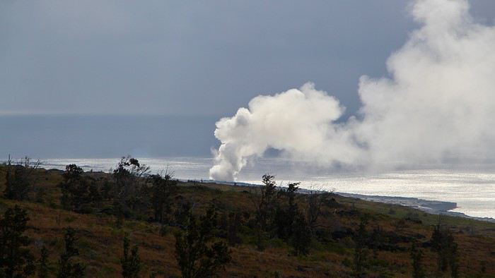
Nous commençons cette journée de bonne heure. A 7h, nous arrivons au Volcanoes NP pour terminer la visite que nous avons commencé la veille. Nous prenons directement la Chain of Craters Road afin de descendre jusqu'à la mer, et nous arrêter aux points de vue sur le chemin.
Nous sommes les seuls, comme c'est agréable! Alors nous profitons d'un point de vue aménagé avec des tables de pique nique pour prendre notre petit déjeuner en plein air. Il fait doux, et cette solitude... on en profite pleinement!

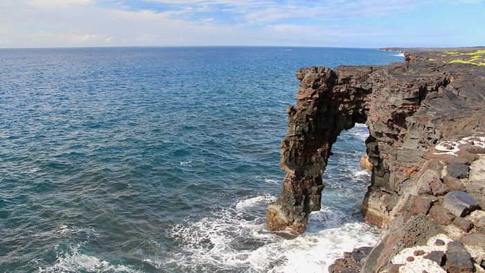
Ensuite, nous poursuivons jusqu'à l'océan. Malheureusement nous n'aurons pas le temps de faire le trail des pietroglyphs, nous avons peur que la journée soit trop courte. Nous passons quelques longues minutes à contempler toujours seuls Holei Arch. Le temps est assez menaçant, alors nous ne tardons pas.

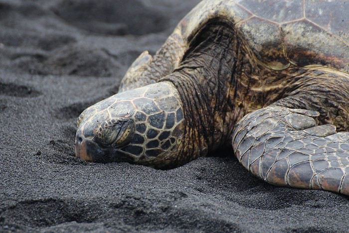
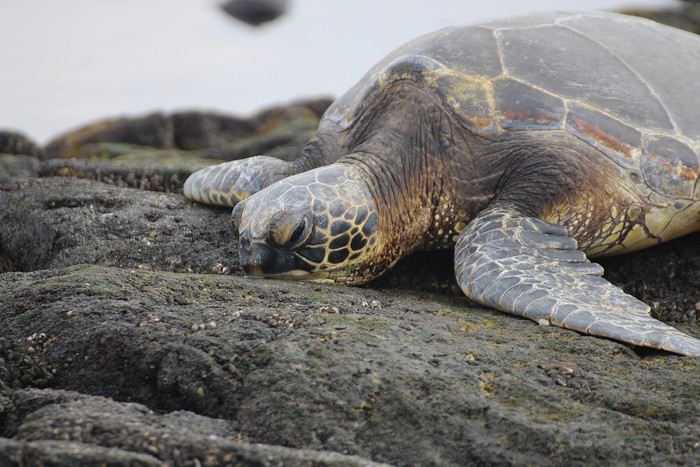
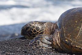
Nous reprenons la route direction le sud de Big Island. La route est assez longue. Au loin on voit très bien l'imposant Mauna Loa. Puis nous arrivons enfin à Punalu'u Beach, réputée pour ses tortues qui viennent régulièrement s'y reposer. Mais aujourd'hui, elles n'ont pas décidé de venir pointer le bout de leur nez, hormis un gros spécimen qui semblait se reposer à quelques mètres du bord de l'eau. La zone a d'ailleurs été protégée par 4 plots pour qu'on ne la dérange pas.

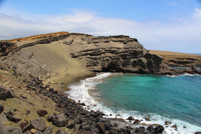
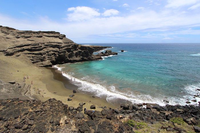
Notre arrêt suivant se fait tout au sud de l'île. Nous déposons notre 4x4 sur le parking de Green Sand beach, appelée aussi Papakolea beach. Nous jetons un oeil à la piste et effectivement, nous ne passerons pas avec notre Jeep Compass. Et puis c'était interdit par le loueur... Du coup nous commençons les 8 km de marche, laissant sur le parking les nombreux démarcheurs vendant un aller-retour à la plage pour 15$ par personne.
En chemin, un 4x4 nous dépasse et le conducteur nous invite à nous emmener à la plage. Un peu surpris, nous lui demandons si la course est gratuite, il nous indique que oui et que ça lui fait plaisir d'amener les touristes à la plage. Un peu interloqués tout de même, nous décidons de monter, accompagnés par 2 autres touristes allemandes.
Après une balade plus que mouvementée, nous arrivons à la plage de sable vert. C'est à ce moment que notre chauffeur nous indique "Si vous souhaitez, je peux vous ramener pour 10$ par personne au parking.". 😏 Sérieusement??? Et bé non, tu n'auras pas nos 20$, nous rentrerons à pied, comme ce qui était prévu, mais au final, merci de l'aller gratuit ^^
Par chance, le ciel qui était couvert se dégage, et un rayon de soleil vient illuminer la plage. C'est superbe! Le sable n'est pas très vert, mais avec le contraste de l'eau c'est très beau. Nous sommes tout de même contents d'être arrivés jusqu'ici même si ce détour est relativement long et nous semble optionnel pour un séjour "court".


Finalement, nous profiterons que de la vue sur la plage, n'ayant pas l'envie de descendre nous y baigner. Nous y resterons qu'une quinzaine de minutes le temps d'admirer l'endroit et d'y faire quelques clichés.
Nous voilà maintenant repartis sur le sentier du retour où des dizaines de chemins partent dans tous les sens. Certains sont plutôt roulant, d'autres très cabossés. Nous comprenons maintenant la supercherie. Notre chauffeur a fait exprès d'emprunter les pires pistes pour nous convaincre de rentrer avec lui, tant l'aller paraissait long! Mais quand on marche tout droit en suivant le chemin le plus court, on se rend compte que ça n'est pas si long. Enfin, tout dépend de ce que "long" signifie pour nous ;) Après 40 minutes d'efforts intensifs à une bonne allure, nous arrivons au parking. Nous sommes assoiffés et trempés de sueur. La balade se fait en plein cagnard et il devait être 13h... pas vraiment la bonne heure pour se lancer dans une rando sans ombre. Mais heureusement, nous y avons survécu.
Nous reprenons la route pour nous rendre à quelques mètres de là, au south point, le point le plus au sud de l'île où serait venu accoster les premiers hawaiien. L'endroit est bondé! C'est étrange, car il y a beaucoup plus de monde qu'au parking de Green Sand Beach. Il y a un ponton en haut d'une falaise d'où sautent les plus aventureux. En bas, il y a une échelle en corde qui permet de remonter, mais pas très évident. Flo hésite longuement à aller piquer une tête mais finalement, il a la flemme de galérer à remonter ;)
Voilà qui sera notre dernier arrêt de cette journée. Le soir arrive et nous sommes enfin à Kona. Le temps est pluvieux, pourvu que ça arrange quand nous irons voir les raies Manta! Mais ça, ça sera l'objet d'une vidéo spéciale, donc à venir dans quelques jours :)
Et comme toujours, la vidéo du jour: youtu.be/FxCxliS-9ME
Aujourd'hui nous quittons le Volcanoes NP pour nous rendre à Kona où nous sommes attendus le soir pour aller voir les raies Manta.
Nous commençons cette journée de bonne heure. A 7h, nous arrivons au Volcanoes NP pour terminer la visite que nous avons commencé la veille. Nous prenons directement la Chain of Craters Road afin de descendre jusqu'à la mer, et nous arrêter aux points de vue sur le chemin.
Nous sommes les seuls, comme c'est agréable! Alors nous profitons d'un point de vue aménagé avec des tables de pique nique pour prendre notre petit déjeuner en plein air. Il fait doux, et cette solitude... on en profite pleinement!

Ensuite, nous poursuivons jusqu'à l'océan. Malheureusement nous n'aurons pas le temps de faire le trail des pietroglyphs, nous avons peur que la journée soit trop courte. Nous passons quelques longues minutes à contempler toujours seuls Holei Arch. Le temps est assez menaçant, alors nous ne tardons pas.

Nous reprenons la route direction le sud de Big Island. La route est assez longue. Au loin on voit très bien l'imposant Mauna Loa. Puis nous arrivons enfin à Punalu'u Beach, réputée pour ses tortues qui viennent régulièrement s'y reposer. Mais aujourd'hui, elles n'ont pas décidé de venir pointer le bout de leur nez, hormis un gros spécimen qui semblait se reposer à quelques mètres du bord de l'eau. La zone a d'ailleurs été protégée par 4 plots pour qu'on ne la dérange pas.

Notre arrêt suivant se fait tout au sud de l'île. Nous déposons notre 4x4 sur le parking de Green Sand beach, appelée aussi Papakolea beach. Nous jetons un oeil à la piste et effectivement, nous ne passerons pas avec notre Jeep Compass. Et puis c'était interdit par le loueur... Du coup nous commençons les 8 km de marche, laissant sur le parking les nombreux démarcheurs vendant un aller-retour à la plage pour 15$ par personne.
En chemin, un 4x4 nous dépasse et le conducteur nous invite à nous emmener à la plage. Un peu surpris, nous lui demandons si la course est gratuite, il nous indique que oui et que ça lui fait plaisir d'amener les touristes à la plage. Un peu interloqués tout de même, nous décidons de monter, accompagnés par 2 autres touristes allemandes.
Après une balade plus que mouvementée, nous arrivons à la plage de sable vert. C'est à ce moment que notre chauffeur nous indique "Si vous souhaitez, je peux vous ramener pour 10$ par personne au parking.". 😏 Sérieusement??? Et bé non, tu n'auras pas nos 20$, nous rentrerons à pied, comme ce qui était prévu, mais au final, merci de l'aller gratuit ^^
Par chance, le ciel qui était couvert se dégage, et un rayon de soleil vient illuminer la plage. C'est superbe! Le sable n'est pas très vert, mais avec le contraste de l'eau c'est très beau. Nous sommes tout de même contents d'être arrivés jusqu'ici même si ce détour est relativement long et nous semble optionnel pour un séjour "court".


Finalement, nous profiterons que de la vue sur la plage, n'ayant pas l'envie de descendre nous y baigner. Nous y resterons qu'une quinzaine de minutes le temps d'admirer l'endroit et d'y faire quelques clichés.
Nous voilà maintenant repartis sur le sentier du retour où des dizaines de chemins partent dans tous les sens. Certains sont plutôt roulant, d'autres très cabossés. Nous comprenons maintenant la supercherie. Notre chauffeur a fait exprès d'emprunter les pires pistes pour nous convaincre de rentrer avec lui, tant l'aller paraissait long! Mais quand on marche tout droit en suivant le chemin le plus court, on se rend compte que ça n'est pas si long. Enfin, tout dépend de ce que "long" signifie pour nous ;) Après 40 minutes d'efforts intensifs à une bonne allure, nous arrivons au parking. Nous sommes assoiffés et trempés de sueur. La balade se fait en plein cagnard et il devait être 13h... pas vraiment la bonne heure pour se lancer dans une rando sans ombre. Mais heureusement, nous y avons survécu.
Nous reprenons la route pour nous rendre à quelques mètres de là, au south point, le point le plus au sud de l'île où serait venu accoster les premiers hawaiien. L'endroit est bondé! C'est étrange, car il y a beaucoup plus de monde qu'au parking de Green Sand Beach. Il y a un ponton en haut d'une falaise d'où sautent les plus aventureux. En bas, il y a une échelle en corde qui permet de remonter, mais pas très évident. Flo hésite longuement à aller piquer une tête mais finalement, il a la flemme de galérer à remonter ;)
Voilà qui sera notre dernier arrêt de cette journée. Le soir arrive et nous sommes enfin à Kona. Le temps est pluvieux, pourvu que ça arrange quand nous irons voir les raies Manta! Mais ça, ça sera l'objet d'une vidéo spéciale, donc à venir dans quelques jours :)
Et comme toujours, la vidéo du jour: youtu.be/FxCxliS-9ME
Retrouvez-nous sur --> https://www.smartrippers.com
USA/Hawaii: 2000, 2012, 2013, 2014, 2017, 2018, 2019
Islande: 2016, 2018, 2020
Japon: 2010, 2015, 2018
1er tour du monde 2019: Polynésie, Hawaii, Nouvelle-Zélande, Singapour et Bali
Ah! C'est trop drôle, nous rentrons de notre journée et je lis ici pratiquement la même que celle que l'on vient de faire car c'est aussi notre journee de transition 😉.
Ce matin nous sommes passé au Volcano mais juste pour quelques photos au Jaggar Museum, avons fait comme vous les plages de sable noire et verte puis filé à Kona oú ce soir il pleut 🙁.
Nous ne ferons probablement pas les raies Manta, demain les plages du sud si il fait beau 😎
"Voyager est un triple plaisir : l'attente, l'éblouissement et le souvenir." Ilka Chase
C'est marrant ça! Et la même météo presque ^^
Le temps n'avait pas été top durant tout notre séjour à Kona, j'espère que pour vous ça sera plus sympa! Two Steps Beach est chouette pour le snorkeling, juste galère pour remonter ;) Sinon ya de jolies plages au nord de Kona aussi.
Retrouvez-nous sur --> https://www.smartrippers.com
USA/Hawaii: 2000, 2012, 2013, 2014, 2017, 2018, 2019
Islande: 2016, 2018, 2020
Japon: 2010, 2015, 2018
1er tour du monde 2019: Polynésie, Hawaii, Nouvelle-Zélande, Singapour et Bali
Bonjour Sandrine,
Merci d'avoir pris le temps de répondre à toutes ces questions ! 😉 Je m'en vais de ce pas poursuivre mes préparatifs ! 😎
Chloé
https://lespilpous.fr
Jour 13 - soirée
Le soleil commence à décliner, et nous n'avons que le temps de rentrer rapidement nous changer à notre Air B&B sur les hauteurs de Kona. Nous prenons notre matériel de snorkeling, nos maillots et serviettes et direction la marina de Kona.
Il y a 2 jours, nous avions réservé sur internet une excursions pour voir les raies Manta. Nous sommes tous excités car nous attendons ce moment avec impatience 😊 Pour cela, nous avons sélectionné Kona Ocean Adventures, que nous avons repéré grâce à leurs bons avis et au fait qu'ils n'embarquent qu'un petit nombre de passagers.
Nous arrivons au parking à l'heure indiqué. Tout le monde est là et ce soir, nous ne serons que 6 passagers par bateau (il y aura 2 bateaux), c'est top! Les bateaux sont rapidement mis à l'eau, on n'a même pas à attendre (ça c'est chouette) et on démarre.
Après quelques bonnes minutes de navigation, nous arrivons au point de snorkeling où il y a déjà de nombreux bateaux ainsi que des personnes dans l'eau. Nous nous équipons, puis nous descendons dans l'eau où nous attend une planche qui nous servira de flotteur pour pouvoir nous accrocher, mais qui éclaire également l'océan, afin d'attirer le plancton dont raffole les raies.
Les raies ne tardent pas à arriver, c'est un vrai spectacle! Pendant près de 40 minutes elles vont réaliser de grands loopings juste sous notre ventre, elles ne passent qu'à quelques centimètres, c'est magique! Elles sont gracieuses et nous arrivons à voir jusqu'à 10 simultanément!
C'est notre grand coup de coeur de ce voyage! Nous ne regrettons vraiment pas d'avoir investit dans cette activité tant le spectacle était incroyable. On s'en souviendra toute notre vie!!
Je ne peux malheureusement pas mettre de photos car n'ayant pas pris le reflex, je n'ai que des images dont la dimension est trop petite pour pouvoir être postées ici. Néanmoins la vidéo de notre excursion résume très bien notre expérience.
https://youtu.be/IhahNrv2jWw
Enfin je conclue avec notre avis sur Kona Ocean Adventures que nous recommandons fortement! Ils ont été top du début à la fin, un bateau spacieux, boissons fraiches à aller, boissons chaudes au retour, douche chaude en sortant de l'eau et plateau de fruits (ananas, pastèque), en plus des explications très précises sur les raies. Ils sont plus chers que la moyenne mais le service est largement à la hauteur du prix!
Le soleil commence à décliner, et nous n'avons que le temps de rentrer rapidement nous changer à notre Air B&B sur les hauteurs de Kona. Nous prenons notre matériel de snorkeling, nos maillots et serviettes et direction la marina de Kona.
Il y a 2 jours, nous avions réservé sur internet une excursions pour voir les raies Manta. Nous sommes tous excités car nous attendons ce moment avec impatience 😊 Pour cela, nous avons sélectionné Kona Ocean Adventures, que nous avons repéré grâce à leurs bons avis et au fait qu'ils n'embarquent qu'un petit nombre de passagers.
Nous arrivons au parking à l'heure indiqué. Tout le monde est là et ce soir, nous ne serons que 6 passagers par bateau (il y aura 2 bateaux), c'est top! Les bateaux sont rapidement mis à l'eau, on n'a même pas à attendre (ça c'est chouette) et on démarre.
Après quelques bonnes minutes de navigation, nous arrivons au point de snorkeling où il y a déjà de nombreux bateaux ainsi que des personnes dans l'eau. Nous nous équipons, puis nous descendons dans l'eau où nous attend une planche qui nous servira de flotteur pour pouvoir nous accrocher, mais qui éclaire également l'océan, afin d'attirer le plancton dont raffole les raies.
Les raies ne tardent pas à arriver, c'est un vrai spectacle! Pendant près de 40 minutes elles vont réaliser de grands loopings juste sous notre ventre, elles ne passent qu'à quelques centimètres, c'est magique! Elles sont gracieuses et nous arrivons à voir jusqu'à 10 simultanément!
C'est notre grand coup de coeur de ce voyage! Nous ne regrettons vraiment pas d'avoir investit dans cette activité tant le spectacle était incroyable. On s'en souviendra toute notre vie!!
Je ne peux malheureusement pas mettre de photos car n'ayant pas pris le reflex, je n'ai que des images dont la dimension est trop petite pour pouvoir être postées ici. Néanmoins la vidéo de notre excursion résume très bien notre expérience.
https://youtu.be/IhahNrv2jWw
Enfin je conclue avec notre avis sur Kona Ocean Adventures que nous recommandons fortement! Ils ont été top du début à la fin, un bateau spacieux, boissons fraiches à aller, boissons chaudes au retour, douche chaude en sortant de l'eau et plateau de fruits (ananas, pastèque), en plus des explications très précises sur les raies. Ils sont plus chers que la moyenne mais le service est largement à la hauteur du prix!
Retrouvez-nous sur --> https://www.smartrippers.com
USA/Hawaii: 2000, 2012, 2013, 2014, 2017, 2018, 2019
Islande: 2016, 2018, 2020
Japon: 2010, 2015, 2018
1er tour du monde 2019: Polynésie, Hawaii, Nouvelle-Zélande, Singapour et Bali
Waouh! C'est magnifique, mon mari est déçu de ne pas l'avoir fait 🙁, nous n'avions pas beaucoup de temps et avions peur de trop de monde. Cette vidéo est arrivée trop tard, je t'avais bien dit de te dépêcher de faire ce carnet avant notre départ 😉. Bonne excuse pour y revenir un jour 😛
"Voyager est un triple plaisir : l'attente, l'éblouissement et le souvenir." Ilka Chase
Oh je suis trop déçue pour vous 😕
Mais toutes les raisons sont bonnes pour retourner à Hawaii! D'ailleurs c'est déjà dans nos projets loingtain 😉
Après malheureusement on essaie de faire les vidéos dès qu'on a un peu de temps mais c'est à chaque fois environ 10h pour chacune. On espère tout finir d'ici notre prochain voyage fin septembre. Sinon c'était la dernière activité de notre séjour, mais on avait écris partout sur notre site que c'était génial 😉 Si tu te pose d'autres questions, n'hésite pas 🙂
Retrouvez-nous sur --> https://www.smartrippers.com
USA/Hawaii: 2000, 2012, 2013, 2014, 2017, 2018, 2019
Islande: 2016, 2018, 2020
Japon: 2010, 2015, 2018
1er tour du monde 2019: Polynésie, Hawaii, Nouvelle-Zélande, Singapour et Bali
Waouh! 10h par vidéo, chapeau bas à tous les deux, c'est un superbe travail 🙂
Pour les raies Manta, ce n'est pas faute d'avoir insisté pour qu'il y aille, mais il n'était pas emballé et moi je ne fais pas de snorkeling et ne vais que très peu dans l'eau 😛
Il s'est consolé aujourd'hui en nageant avec une vingtaine de tortue à Ko'opika Beach, le top 🙂.
"Voyager est un triple plaisir : l'attente, l'éblouissement et le souvenir." Ilka Chase
20 tortues!! 😮 Ohhh le chanceux 😎 Effectivement c'est un superbe lot de consolation, ça a dû être incroyable!!
Retrouvez-nous sur --> https://www.smartrippers.com
USA/Hawaii: 2000, 2012, 2013, 2014, 2017, 2018, 2019
Islande: 2016, 2018, 2020
Japon: 2010, 2015, 2018
1er tour du monde 2019: Polynésie, Hawaii, Nouvelle-Zélande, Singapour et Bali
Merci Sandrine pour la suite de vos aventures..Super les raies manta...cela me permet de voir ce que j'ai raté et de rajouter une raison d'y retourner même si la liste est déjà plus que suffisante 😉
on est rentré dans la grisaille et les 15c de la Belgique...
on n'a pas fait green sand beach parce que on a estimé que cela prenait trop de temps pour ce que l'on risquait de voir.
On a préféré prendre plus de temps pour le volcano NP, les environs de Pahoa et Hilo.
C'est du coté Sud est de big island que l'on a eut le plus mauvais temps de notre séjour avec pas mal de pluie mais toujours avec cette chaleur agréable. (residu de l ouragan fernanda qui a fini en grosse tempête à 1000 km d'hawaii d'après les locaux).
Je pense que vous avez eu raison pour Green Sand beach. C'est le conseil qu'on donnerait également. Côté météo, vous n'avez pas eu de chance :( 1000 km c'est pas si loin! Heureusement qu'il est passé à côté finalement ^^
J'espère que vous n'avez pas trop le blues du retour. Il faudrait y revenir plusieurs mois pour tout découvrir, il y a encore tant à voir! Au plaisir de se recroiser pour les préparatifs d'un futur voyage 😇
Retrouvez-nous sur --> https://www.smartrippers.com
USA/Hawaii: 2000, 2012, 2013, 2014, 2017, 2018, 2019
Islande: 2016, 2018, 2020
Japon: 2010, 2015, 2018
1er tour du monde 2019: Polynésie, Hawaii, Nouvelle-Zélande, Singapour et Bali
Votre carnet est super bien ! Après avoir passé 7J sur Kauai et 7J sur Big Island je ne peux qu’approuver vos conseils. Vos photos reflètent très bien les paysages extraordinaires de cette archipel 😎 Je suis allé faire un tour sur votre blog et il est très bien fait, félicitations car vos vlogs sont très instructifs pour des personnes ne connaissant pas du tout. Continuez comme ca car vous faites du super boulot 🙂
Pierre
Pierre et Laura, les Deux Évadés
Notre blog : https://deuxevades.com/
4 mois aux USA et Canada : https://deuxevades.com/4-mois-de-voyage-aux-etats-unis-et-canada/
3 ans au Québec : https://deuxevades.com/canada/quebec/
6 mois au Chili : https://deuxevades.com/chili/
Merci c'est très gentil, on est content que notre travaille plaise 🙂 Et on ne compte bien ne pas en rester là 😉 La suite arrive !!
Retrouvez-nous sur --> https://www.smartrippers.com
USA/Hawaii: 2000, 2012, 2013, 2014, 2017, 2018, 2019
Islande: 2016, 2018, 2020
Japon: 2010, 2015, 2018
1er tour du monde 2019: Polynésie, Hawaii, Nouvelle-Zélande, Singapour et Bali
Jour 14
Ca y est, déjà 2 semaines que nous sommes à Hawaii, mais il nous reste encore beaucoup à découvrir! Ce matin nous prenons notre temps. Avec l'excursion de la veille nous sommes rentrés tard, et une bonne grasse' mat nous remet d'aplomb. Après tout ça n'est que la deuxième du séjour, soit un ratio d'une par semaine ;)
Nous quittons notre petit studio de Kona à 11h. Nous passons à la station service faire le plein et prendre quelques provisions, car aujourd'hui, nous allons attaquer le plus gros morceaux du voyage: le Mauna Kea.
Etant donné qu'on est pas du tout habitué à l'altitude, nous allons prendre le temps de monter tranquillement par étapes, surtout qu'on est un peu enrhumés (le comble ^^). Après environ 45 minutes de route, on s'arrête à l'air de pique-nique du Mauna Kea Recreation Area situé à déjà 2000 mètres d'altitude. Ca tombe bien, il est midi, le temps de se remplir le ventre, et d'une pierre deux coups, cette étape permettra déjà de nous habituer un peu aux hautes altitudes.
Après cette pause, nous reprenons ensuite la route pour rallier le visitor center. La route se fait facilement et ne semble pas être très raide. On se retrouve rapidement dans le brouillard, et on espère bien vite émerger au dessus des nuages. Mais il n'en est rien.
On arrive au Visitor Center à 2 800 mètres. Nous ne sommes plus dans les nuages, mais il en reste une bonne couche au dessus de nous. On espère que le sommet aura la tête au dessus des nuages car la couverture nuageuse à l'air bien épaisse. On rentre dans le petit bâtiment, avec un premier arrêt aux sanitaires où les lumières sont des néons rouges!! C'est vraiment étrange! On comprendra le soir les raisons de cet éclairage surprenant. On se rend ensuite dans le hall principal où se trouve un grand comptoir avec une ranger ainsi que quelques chaises et un film qui passe à la TV. On imaginait l'endroit plus accueillant un peu comme au Volcanoes NP, mais ici c'est vraiment sommaire, il n'y a pas de quoi y passer des heures! Du coup on se cale devant la TV, on est tout seul.
Finalement le documentaire est bien, et on le regarde bien pendant 30 à 40 min, le temps pour nos organismes de bien s'adapter à notre nouvelle altitude.
Maintenant nous sommes prêts à repartir. A ce point, la route se transforme en piste, et n'est donc accessible qu'aux véhicules 4x4. Nous emprunterons ce dernier morceau avec notre Jeep Cherokee. Nous ne serons pas assurés car aucun loueur, hormis Harper, autorise cette piste, mais de l'aveu du gars au comptoir de Thrifty à Kona, il n'y a aucun risque de la prendre avec ce type de véhicule. Et zou, c'est parti!
Ca monte plus raide, enfin on a la sensation de grimper! La piste est propre, juste quelques portions façon "tôle ondulée", quelques nids de poule, mais pas plus. Elle est en bon état. On fait quelques épingles et on enchaine les km jusqu'au sommet. Et à son approche, miracle, les nuages se dissipent et on peut enfin apercevoir le ciel bleu!!
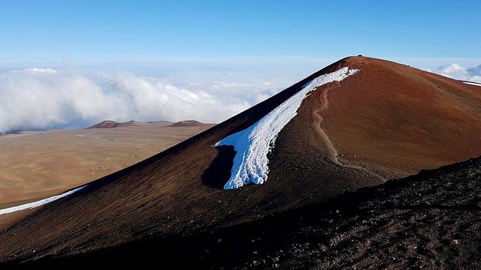
Tous contents, on s'arrête sur le parking au départ du Wai'au trail. On est motivé pour aller rendre une petite visite au petit lac vert sacré, où les hawaiien avaient pour habitude de jeter les cordons ombilicaux de leurs bébés, pour leur donner la force de la montagne!
Mais avant ça, on reste bien 30 minutes dans la voiture. Voila que le mal d'altitude commence à nous atteindre. Nous sommes à 3 900 mètres d'altitude et on se sent très bizarre, surtout Flo qui a quelques nausées. On attend donc que ces sensations désagréables passent, et effectivement, après ces longues minutes, c'est le cas. Nous voici alors dehors.
Et hop, on commence l'ascension d'un pas décidé, sauf qu'au bout de 10 pas on en peut plus. Notre rythme cardiaque doit frôler les 200 et on respire difficilement. Qu'est ce qu'on a été bêtes de se lancer de cette façon! Du coup on ralenti... terriblement. On pose un pied devant l'autre en soufflant lentement. On croirait avoir d'un coup 90 ans et on met une éternité à faire les quelques centaines de mètres qui nous séparent du lac.
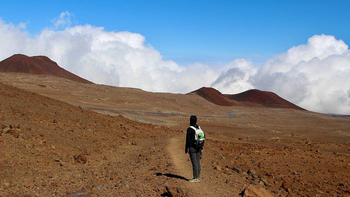
Finalement, on trouve notre rythme de croisière et on continue de monter lentement. On arrive à une intersection, et on suit notre guide qui nous indique de prendre à droite. On continue à monter mais pas de lac... Bizarre. On sort le GPS et on se rend compte qu'il fallait prendre à gauche à l'intersection. Et zut, on a monté tout ça pour rien, merci le guide! Du coup, on est pas motivé pour descendre et remonter après, alors on coupe au travers du champ de lave en descendant.
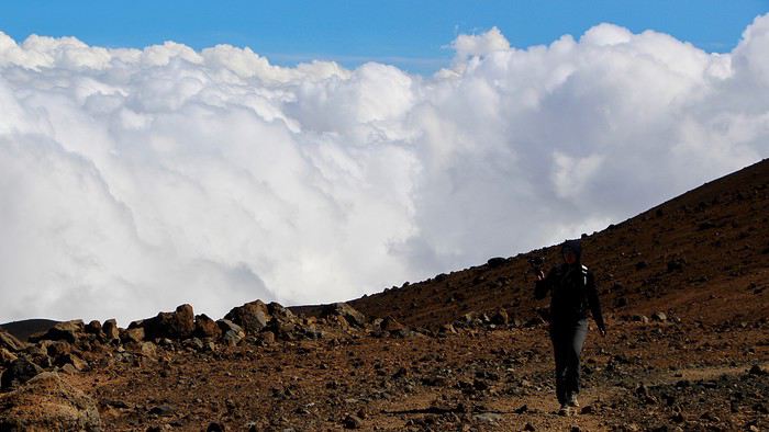
C'est tout de même sportif car il y a des rochers à éviter. Mais enfin, on arrive en vue du lac!!! Quel soulagement! On a l'impression d'avoir grimpé l'Everest alors qu'on a dû marcher 1,5 km 😄 Et voilà le beau lac vert. Finalement la vue est pas mal d'ici, car d'en bas on serait arrivés sur le bord du lac on n'aurait probablement pas pu voir sa teinte verte.
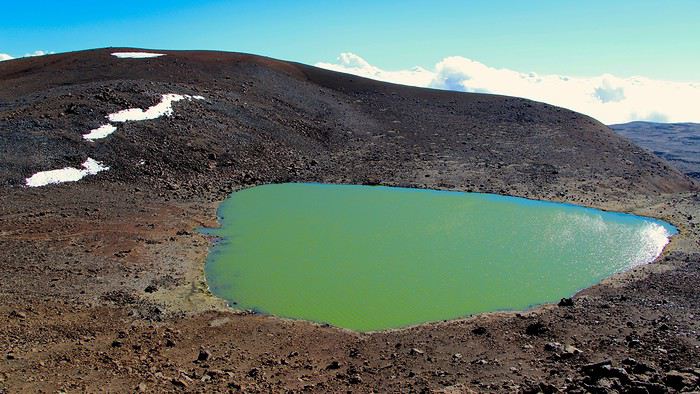
On scrute la surface, et on ne voit rien flotter (si vous vous posiez la question 😏)
Maintenant il est temps de retourner à notre voiture. On aurait pu faire un boucle en faisant le tour complet du petit cratère juste à côté, mais comme il fallait encore monter un peu, on a préféré directement redescendre, tant pis. On regagne la voiture et on file vers le sommet. Il est 17h et la fin de journée approche.
On se stationne à l'emplacement idéal pour observer le coucher du soleil depuis la voiture, et l'on a bien fait car quand on sort de la voiture, un vent fort et glacial vient nous congeler sur place! Brrrr, ça caille! D'après les relevés, il fait environ 2 degrés. C'est assurément vivifiant!
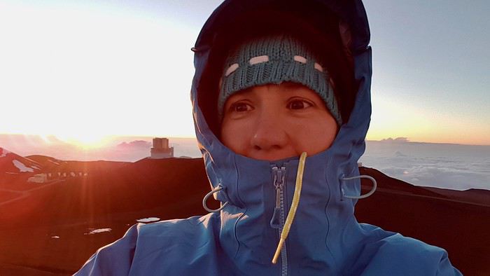
On fait rapidement le tour de la plateforme au sommet mais avec ce vent c'est vraiment désagréable. Du coup on rentre dans la voiture se réchauffer en attendant le coucher du soleil.
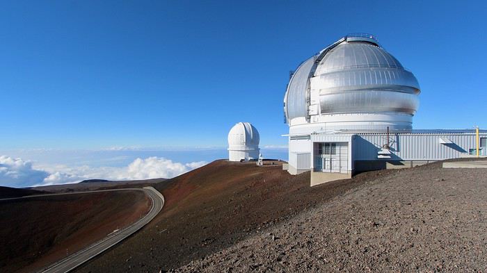
Plus tard, d'autres 4x4 viendront se joindre à nous, mais nous resterons peu nombreux. Quelques minutes avant le coucher du soleil, les mini bus viendront faire escale et se garer au pied de la coupole la plus proche du parking. On n'envie vraiment pas les personnes qui ont pris les excursions qui doivent se les geler alors que nous sommes au chaud dans la voiture.
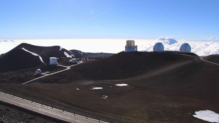
On sort tout de même sur la fin pour admirer de nos yeux, et pas dernière une vitre, le soleil décliner derrière l'immense mer de nuages. C'était vraiment beau!
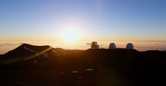
Nous profitons jusqu'au dernières gouttes de soleil avant de redescendre. Les mini bus, eux, sont partis depuis longtemps. En redescendant, on voit bien le Mauna Loa sortir des nuages. On s'arrête à nouveau au petit parking de la rando du lac, pour attendre que l'obscurité complète arrive et nous permette de bien voir le ciel étoilé. Quel merveille, c'est assurément le plus beau ciel étoilé que j'ai vu jusqu'à présent! Et bêtement, on n'a pas pensé à prendre de photos de la Voie Lactée 🏴☠️
On re-descent ensuite jusqu'au visitor center, qui organise ce soir là, une soirée sur l'astronomie (ça a lieu plusieurs soirs par semaine). Il y a du monde, c'est même blindé, mais on trouve facilement à stationner. En face du visitor center, on se fraye un chemin à travers la foule. Un conférencier raconte plein de légendes à propos des étoiles, en les pointants avec son laser. C'est intéressant mais il faut suivre son rythme.
On remarque ensuite qu'il y a plein de téléscopes déployés, des petits mais aussi des très gros. Au début on n'ose pas y toucher, mais finalement, voyant qu'ils semblent mis à notre disposition, on regarde dedans. Et on a bien fait, car après nous avoir vu, tout le monde les a pris d'assaut! On s'approche alors d'un gros télescope électronique dont l'écran à balayage était en train d'afficher une galaxie! C'est fascinant de pouvoir la découvrir en direct!!
Avant de repartir on retourne faire un tour aux toilettes avec leur lumière rouge. Et voilà que tout s'éclaire! La lumière rouge est en fait un moyen de ne pas nous éblouir lors des soirées d'astronomie! Car effectivement, autour du visitor center c'est le noir total, il y a juste quelques LED au sol, mais aucune autre lumière!!
Voilà ce qui clos cette journée! Le temps de rentrer, nous regagnerons notre studio sur les coups de minuit.
Comme d'habitude, retour sur cette épopée en images, surtout si vous vous demandez à quoi ressemble la piste de 4x4 qui mène au sommet.
https://youtu.be/AXlq7Y6ax7A
Et si vous souhaitez plus d'information sur les accès au Mauna Kea et les choses à y découvrir, vous pouvez consulter notre article complet: https://www.smartrippers.com/fr/article/gravir-le-mauna-kea-le-plus-haut-sommet-d-hawaii


Ca y est, déjà 2 semaines que nous sommes à Hawaii, mais il nous reste encore beaucoup à découvrir! Ce matin nous prenons notre temps. Avec l'excursion de la veille nous sommes rentrés tard, et une bonne grasse' mat nous remet d'aplomb. Après tout ça n'est que la deuxième du séjour, soit un ratio d'une par semaine ;)
Nous quittons notre petit studio de Kona à 11h. Nous passons à la station service faire le plein et prendre quelques provisions, car aujourd'hui, nous allons attaquer le plus gros morceaux du voyage: le Mauna Kea.
Etant donné qu'on est pas du tout habitué à l'altitude, nous allons prendre le temps de monter tranquillement par étapes, surtout qu'on est un peu enrhumés (le comble ^^). Après environ 45 minutes de route, on s'arrête à l'air de pique-nique du Mauna Kea Recreation Area situé à déjà 2000 mètres d'altitude. Ca tombe bien, il est midi, le temps de se remplir le ventre, et d'une pierre deux coups, cette étape permettra déjà de nous habituer un peu aux hautes altitudes.
Après cette pause, nous reprenons ensuite la route pour rallier le visitor center. La route se fait facilement et ne semble pas être très raide. On se retrouve rapidement dans le brouillard, et on espère bien vite émerger au dessus des nuages. Mais il n'en est rien.
On arrive au Visitor Center à 2 800 mètres. Nous ne sommes plus dans les nuages, mais il en reste une bonne couche au dessus de nous. On espère que le sommet aura la tête au dessus des nuages car la couverture nuageuse à l'air bien épaisse. On rentre dans le petit bâtiment, avec un premier arrêt aux sanitaires où les lumières sont des néons rouges!! C'est vraiment étrange! On comprendra le soir les raisons de cet éclairage surprenant. On se rend ensuite dans le hall principal où se trouve un grand comptoir avec une ranger ainsi que quelques chaises et un film qui passe à la TV. On imaginait l'endroit plus accueillant un peu comme au Volcanoes NP, mais ici c'est vraiment sommaire, il n'y a pas de quoi y passer des heures! Du coup on se cale devant la TV, on est tout seul.
Finalement le documentaire est bien, et on le regarde bien pendant 30 à 40 min, le temps pour nos organismes de bien s'adapter à notre nouvelle altitude.
Maintenant nous sommes prêts à repartir. A ce point, la route se transforme en piste, et n'est donc accessible qu'aux véhicules 4x4. Nous emprunterons ce dernier morceau avec notre Jeep Cherokee. Nous ne serons pas assurés car aucun loueur, hormis Harper, autorise cette piste, mais de l'aveu du gars au comptoir de Thrifty à Kona, il n'y a aucun risque de la prendre avec ce type de véhicule. Et zou, c'est parti!
Ca monte plus raide, enfin on a la sensation de grimper! La piste est propre, juste quelques portions façon "tôle ondulée", quelques nids de poule, mais pas plus. Elle est en bon état. On fait quelques épingles et on enchaine les km jusqu'au sommet. Et à son approche, miracle, les nuages se dissipent et on peut enfin apercevoir le ciel bleu!!

Tous contents, on s'arrête sur le parking au départ du Wai'au trail. On est motivé pour aller rendre une petite visite au petit lac vert sacré, où les hawaiien avaient pour habitude de jeter les cordons ombilicaux de leurs bébés, pour leur donner la force de la montagne!
Mais avant ça, on reste bien 30 minutes dans la voiture. Voila que le mal d'altitude commence à nous atteindre. Nous sommes à 3 900 mètres d'altitude et on se sent très bizarre, surtout Flo qui a quelques nausées. On attend donc que ces sensations désagréables passent, et effectivement, après ces longues minutes, c'est le cas. Nous voici alors dehors.
Et hop, on commence l'ascension d'un pas décidé, sauf qu'au bout de 10 pas on en peut plus. Notre rythme cardiaque doit frôler les 200 et on respire difficilement. Qu'est ce qu'on a été bêtes de se lancer de cette façon! Du coup on ralenti... terriblement. On pose un pied devant l'autre en soufflant lentement. On croirait avoir d'un coup 90 ans et on met une éternité à faire les quelques centaines de mètres qui nous séparent du lac.

Finalement, on trouve notre rythme de croisière et on continue de monter lentement. On arrive à une intersection, et on suit notre guide qui nous indique de prendre à droite. On continue à monter mais pas de lac... Bizarre. On sort le GPS et on se rend compte qu'il fallait prendre à gauche à l'intersection. Et zut, on a monté tout ça pour rien, merci le guide! Du coup, on est pas motivé pour descendre et remonter après, alors on coupe au travers du champ de lave en descendant.

C'est tout de même sportif car il y a des rochers à éviter. Mais enfin, on arrive en vue du lac!!! Quel soulagement! On a l'impression d'avoir grimpé l'Everest alors qu'on a dû marcher 1,5 km 😄 Et voilà le beau lac vert. Finalement la vue est pas mal d'ici, car d'en bas on serait arrivés sur le bord du lac on n'aurait probablement pas pu voir sa teinte verte.

On scrute la surface, et on ne voit rien flotter (si vous vous posiez la question 😏)
Maintenant il est temps de retourner à notre voiture. On aurait pu faire un boucle en faisant le tour complet du petit cratère juste à côté, mais comme il fallait encore monter un peu, on a préféré directement redescendre, tant pis. On regagne la voiture et on file vers le sommet. Il est 17h et la fin de journée approche.
On se stationne à l'emplacement idéal pour observer le coucher du soleil depuis la voiture, et l'on a bien fait car quand on sort de la voiture, un vent fort et glacial vient nous congeler sur place! Brrrr, ça caille! D'après les relevés, il fait environ 2 degrés. C'est assurément vivifiant!

On fait rapidement le tour de la plateforme au sommet mais avec ce vent c'est vraiment désagréable. Du coup on rentre dans la voiture se réchauffer en attendant le coucher du soleil.

Plus tard, d'autres 4x4 viendront se joindre à nous, mais nous resterons peu nombreux. Quelques minutes avant le coucher du soleil, les mini bus viendront faire escale et se garer au pied de la coupole la plus proche du parking. On n'envie vraiment pas les personnes qui ont pris les excursions qui doivent se les geler alors que nous sommes au chaud dans la voiture.

On sort tout de même sur la fin pour admirer de nos yeux, et pas dernière une vitre, le soleil décliner derrière l'immense mer de nuages. C'était vraiment beau!

Nous profitons jusqu'au dernières gouttes de soleil avant de redescendre. Les mini bus, eux, sont partis depuis longtemps. En redescendant, on voit bien le Mauna Loa sortir des nuages. On s'arrête à nouveau au petit parking de la rando du lac, pour attendre que l'obscurité complète arrive et nous permette de bien voir le ciel étoilé. Quel merveille, c'est assurément le plus beau ciel étoilé que j'ai vu jusqu'à présent! Et bêtement, on n'a pas pensé à prendre de photos de la Voie Lactée 🏴☠️
On re-descent ensuite jusqu'au visitor center, qui organise ce soir là, une soirée sur l'astronomie (ça a lieu plusieurs soirs par semaine). Il y a du monde, c'est même blindé, mais on trouve facilement à stationner. En face du visitor center, on se fraye un chemin à travers la foule. Un conférencier raconte plein de légendes à propos des étoiles, en les pointants avec son laser. C'est intéressant mais il faut suivre son rythme.
On remarque ensuite qu'il y a plein de téléscopes déployés, des petits mais aussi des très gros. Au début on n'ose pas y toucher, mais finalement, voyant qu'ils semblent mis à notre disposition, on regarde dedans. Et on a bien fait, car après nous avoir vu, tout le monde les a pris d'assaut! On s'approche alors d'un gros télescope électronique dont l'écran à balayage était en train d'afficher une galaxie! C'est fascinant de pouvoir la découvrir en direct!!
Avant de repartir on retourne faire un tour aux toilettes avec leur lumière rouge. Et voilà que tout s'éclaire! La lumière rouge est en fait un moyen de ne pas nous éblouir lors des soirées d'astronomie! Car effectivement, autour du visitor center c'est le noir total, il y a juste quelques LED au sol, mais aucune autre lumière!!
Voilà ce qui clos cette journée! Le temps de rentrer, nous regagnerons notre studio sur les coups de minuit.
Comme d'habitude, retour sur cette épopée en images, surtout si vous vous demandez à quoi ressemble la piste de 4x4 qui mène au sommet.
https://youtu.be/AXlq7Y6ax7A
Et si vous souhaitez plus d'information sur les accès au Mauna Kea et les choses à y découvrir, vous pouvez consulter notre article complet: https://www.smartrippers.com/fr/article/gravir-le-mauna-kea-le-plus-haut-sommet-d-hawaii

Retrouvez-nous sur --> https://www.smartrippers.com
USA/Hawaii: 2000, 2012, 2013, 2014, 2017, 2018, 2019
Islande: 2016, 2018, 2020
Japon: 2010, 2015, 2018
1er tour du monde 2019: Polynésie, Hawaii, Nouvelle-Zélande, Singapour et Bali
Bonsoir Sandrine,
Nous voilà de retour de nos 3 semaines et je me régale toujours autant à lire ton carnet. Et maintenant, ce n'est plus la hâte d'y être mais pleins de beaux souvenirs qui sont encore tout frais qui resurgissent.
Superbe le lac vert, cette randonnée donne bien envie, eh oui, à cette altitude il faut marcher au ralenti 😉.
Pour Mauna Kea, Nous n'avions pas louer de Jeep, et impossible d'en trouver une pour une journée, du coup nous avons pris une excursion car nous n'avons pas voulu renoncer à voir le coucher de soleil. C'était super, il est vrai que la prochaine fois, nous enticiperons mieux car nous sommes aussi des adeptes du solo 🙂
"Voyager est un triple plaisir : l'attente, l'éblouissement et le souvenir." Ilka Chase
Bonjour Isabelle,
Merci, c'est vraiment gentil 😊
C'est vrai qu'on continue à vivre le voyage au travers des récits des autres. Une amie en revient également et j'ai eu l'impression d'y retourner à travers ces yeux. Depuis qu'on est rentré, on ne rêve que d'y retourner!
C'est dommage pour la Jeep mais vous avez bien fait pour l'excursion. Ca aurait été dommage de rentrer sans l'avoir fait ^^
Et à quand ton carnet? 😏
C'est dommage pour la Jeep mais vous avez bien fait pour l'excursion. Ca aurait été dommage de rentrer sans l'avoir fait ^^
Et à quand ton carnet? 😏
Retrouvez-nous sur --> https://www.smartrippers.com
USA/Hawaii: 2000, 2012, 2013, 2014, 2017, 2018, 2019
Islande: 2016, 2018, 2020
Japon: 2010, 2015, 2018
1er tour du monde 2019: Polynésie, Hawaii, Nouvelle-Zélande, Singapour et Bali
Jour 15
Ce matin il fait tout brumeux et il n’y a pas trop de vent, du coup, la journée ne s’annonce pas très belle. On en profite pour descendre au sud de Kona pour nous rendre au site historique et sacré de Pu'uhonua o Hōnaunau, qui est aussi un National Park, dont l’entrée est à 5$ par voiture.
Sur place, on constate vite que le site est hautement symbolique pour les hawaiiens. Tout est interdit, jusqu’à se mettre de la crème solaire près des bâtiments (enfin je les comprends un peu).
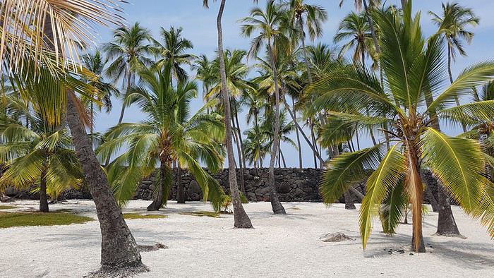
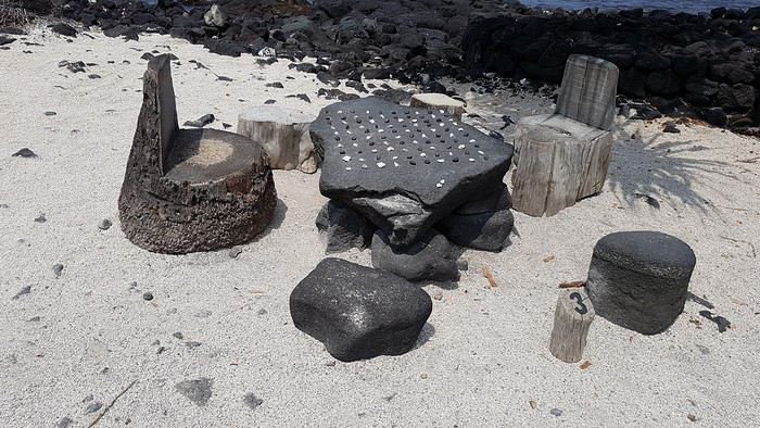
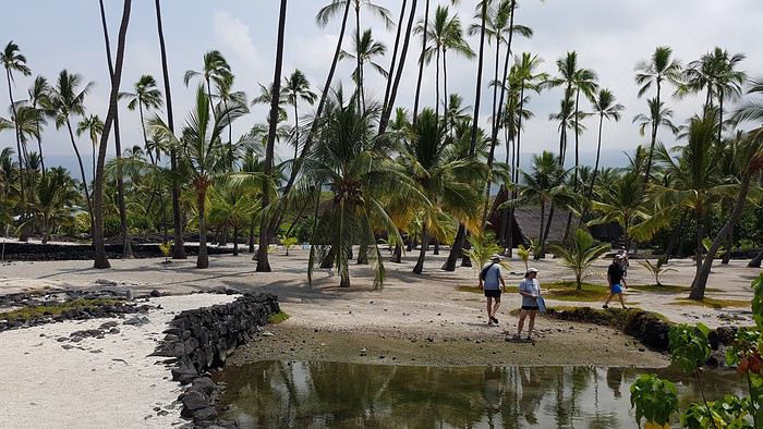
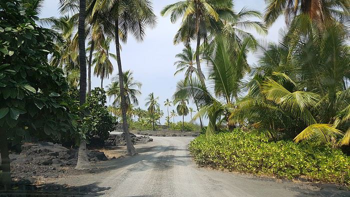
On entre alors dans une zone couverte de palmiers et de sable blanc. C’est vraiment beau ! Des vestiges d’anciennes habitations ont été reconstitués, et on trouve également quelques objets de la vie courante de jadis, comme une table de jeu très bien conservée.


On arrive ensuite à un sanctuaire très sacré où les ossements des grands chefs ont été conservés ici. On vous raconte en détail dans la vidéo le fonctionnement du site sacré.
On passera une bonne heure à découvrir l’endroit, puis on se rendra en voiture à une zone très sympa pour pique-niquer au sud du parc, mais comme il est encore tôt, on fait demi-tour.

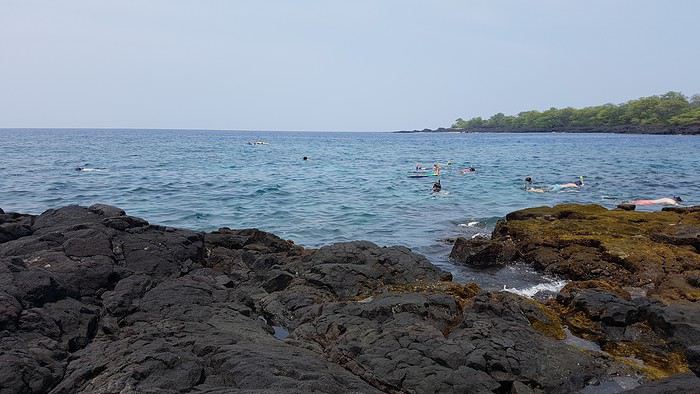
On se rend ensuite à Two Steps Beach, le célèbre spot de snorkeling situé juste au nord du parc. On accède à l’eau par une zone de rochers plutôt coupants, donc ça n’est pas ici qu’on posera notre serviette. On arrive au bord de l’eau et on voit une tortue au bord du rivage ! Ni une, ni deux, on s’équipe et on se met à l’eau, mais hélas la tortue n’est déjà plus là. On la cherche, en vain 😕

Mais les jolis poissons jaunes et les coraux colorés et abondants nous ferons oublier l’échec de cette rencontre. Ce spot de snorkeling entre directement à la 2nd place de notre classement.
Il est maintenant l’heure de manger. Pour cela, on s’approche de la baie de Kealakekua, en face du James Cook Monument, et une fois arrivés, on se rend compte qu’on a oublié notre pique-nique à l’appart 🏴☠️
On hésite, car on n’a pas envie de refaire la route pour le chercher, mais en même temps, on avait préparé plein de fruits frais et de bons avocats aux crevettes qui ne se conserveront pas le lendemain, le tout ayant été oublié hors du frigo. On prend donc la décision de rentrer récupérer notre pique-nique que l’on mangera à notre appart de Kona.
La journée est déjà bien entamée, et avec la météo qui ne s’arrange pas, on traine un peu à l’appart pour ressortir en fin d’après-midi et nous rendre au Kahuluu Beach Park. On nous promet des myriades de poissons, qui ne viendront pas. Du coup, on quitte la plage un peu déçus de n’avoir pas vu grand-chose.

On terminera la journée à Kona, dans le centre ville animé au bord de la plage, où il est agréable de flâner en soirée.
En on termine par la vidéo, où l'on peut voir les images du snorkeling, car la résolution de la vidéo en 1080 ne permet pas d'intégrer des photos dans le récit. youtu.be/vuwQsglY59Q
Ce matin il fait tout brumeux et il n’y a pas trop de vent, du coup, la journée ne s’annonce pas très belle. On en profite pour descendre au sud de Kona pour nous rendre au site historique et sacré de Pu'uhonua o Hōnaunau, qui est aussi un National Park, dont l’entrée est à 5$ par voiture.
Sur place, on constate vite que le site est hautement symbolique pour les hawaiiens. Tout est interdit, jusqu’à se mettre de la crème solaire près des bâtiments (enfin je les comprends un peu).
On entre alors dans une zone couverte de palmiers et de sable blanc. C’est vraiment beau ! Des vestiges d’anciennes habitations ont été reconstitués, et on trouve également quelques objets de la vie courante de jadis, comme une table de jeu très bien conservée.


On arrive ensuite à un sanctuaire très sacré où les ossements des grands chefs ont été conservés ici. On vous raconte en détail dans la vidéo le fonctionnement du site sacré.
On passera une bonne heure à découvrir l’endroit, puis on se rendra en voiture à une zone très sympa pour pique-niquer au sud du parc, mais comme il est encore tôt, on fait demi-tour.

On se rend ensuite à Two Steps Beach, le célèbre spot de snorkeling situé juste au nord du parc. On accède à l’eau par une zone de rochers plutôt coupants, donc ça n’est pas ici qu’on posera notre serviette. On arrive au bord de l’eau et on voit une tortue au bord du rivage ! Ni une, ni deux, on s’équipe et on se met à l’eau, mais hélas la tortue n’est déjà plus là. On la cherche, en vain 😕

Mais les jolis poissons jaunes et les coraux colorés et abondants nous ferons oublier l’échec de cette rencontre. Ce spot de snorkeling entre directement à la 2nd place de notre classement.
Il est maintenant l’heure de manger. Pour cela, on s’approche de la baie de Kealakekua, en face du James Cook Monument, et une fois arrivés, on se rend compte qu’on a oublié notre pique-nique à l’appart 🏴☠️
On hésite, car on n’a pas envie de refaire la route pour le chercher, mais en même temps, on avait préparé plein de fruits frais et de bons avocats aux crevettes qui ne se conserveront pas le lendemain, le tout ayant été oublié hors du frigo. On prend donc la décision de rentrer récupérer notre pique-nique que l’on mangera à notre appart de Kona.
La journée est déjà bien entamée, et avec la météo qui ne s’arrange pas, on traine un peu à l’appart pour ressortir en fin d’après-midi et nous rendre au Kahuluu Beach Park. On nous promet des myriades de poissons, qui ne viendront pas. Du coup, on quitte la plage un peu déçus de n’avoir pas vu grand-chose.

On terminera la journée à Kona, dans le centre ville animé au bord de la plage, où il est agréable de flâner en soirée.
En on termine par la vidéo, où l'on peut voir les images du snorkeling, car la résolution de la vidéo en 1080 ne permet pas d'intégrer des photos dans le récit. youtu.be/vuwQsglY59Q
Retrouvez-nous sur --> https://www.smartrippers.com
USA/Hawaii: 2000, 2012, 2013, 2014, 2017, 2018, 2019
Islande: 2016, 2018, 2020
Japon: 2010, 2015, 2018
1er tour du monde 2019: Polynésie, Hawaii, Nouvelle-Zélande, Singapour et Bali
Bonsoir Sandrine et Flo,
Bravo pour toutes ces vidéos et votre blog. Je suis vos aventures depuis quelques semaines. Belle préparation. A Two Steps Beach, vous n'avez pas vu la colonie de dauphins. J'ai lu dans beaucoup de carnets (C'est vrai que je lis beaucoup de carnets sur Hawaï en ce moment en préparation de notre voyage de fin avril) la présence de dauphins dans cette zone. J'attends la suite avec impatience.
Bonjour Sandrine et Flo
Nous sommes présentement à Hawaï pour notre dernière journée et nous avons visité ce parc de Honaunau avant-hier. Quel beau site! Hier, nous sommes montés au sommet du Mauna Kea. Malheureusement, pas de coucher de soleil pour nous, puisque le sommet était dans le brouillard complet. Nous pouvions à peine voir les télescopes, de sorte que nous n'avons pas randonné jusqu'au lac, la pluie s'étant mis de la partie. Nous aurions dû mieux planifier cette journée en visitant le site internet pour les prévisions météorologiques. C'est en faisant une pause au centre des visiteurs que nous avons constaté la mauvaise visibilité sur la Web cam d'un des télescopes au sommet. Pas de "stargazing" non plus. On y était le lundi, et les représentations sont les mardi, mercredi, vendredi et samedi.😕 Je me répète, mais ton carnet est génial.
Et à quand ton carnet? 😏
Attend, je suis entrain d'atterrir et de sortir de mon petit nuage 😊 mais surtout il faut qu'on commence à trier les photos 😉
"Voyager est un triple plaisir : l'attente, l'éblouissement et le souvenir." Ilka Chase
Merci Hervé, c'est très gentil 🙂
Alors oui, nous savions qu'il y avait des dauphins pas loin, qui sont généralement visibles au niveau de la baie de Kealakekua. Mais malheureusement, nous étions à sec financièrement 🤪 ce qui nous a empêché de faire une sortie supplémentaire après les raies Manta. Mais on y retournera ^^
Retrouvez-nous sur --> https://www.smartrippers.com
USA/Hawaii: 2000, 2012, 2013, 2014, 2017, 2018, 2019
Islande: 2016, 2018, 2020
Japon: 2010, 2015, 2018
1er tour du monde 2019: Polynésie, Hawaii, Nouvelle-Zélande, Singapour et Bali
Oh zut, quelle poisse 😮 je suis vraiment déçue pour vous 😐 surtout que c'est assez rare.
Bon après, on a vécu la même mais pour le Haleakala (à découvrir d'ici quelques jours).
Effectivement, comme vous on a appris trop tard l'existence des webcams. Par contre, on parlait des jours du Glazing Star programme sur notre site 😄 (tu pourras pas m'en vouloir 😇) mais si le ciel était bouché, vous n'aurez rien vu non plus. A cette météo, qu'elle est parfois cruelle 😕
Profitez à fond du dernier jour!!! Et revenez-nous avec des souvenirs plein la tête ^^ Et encore merci pour tous les messages d'encouragement. 😊
Effectivement, comme vous on a appris trop tard l'existence des webcams. Par contre, on parlait des jours du Glazing Star programme sur notre site 😄 (tu pourras pas m'en vouloir 😇) mais si le ciel était bouché, vous n'aurez rien vu non plus. A cette météo, qu'elle est parfois cruelle 😕
Profitez à fond du dernier jour!!! Et revenez-nous avec des souvenirs plein la tête ^^ Et encore merci pour tous les messages d'encouragement. 😊
Retrouvez-nous sur --> https://www.smartrippers.com
USA/Hawaii: 2000, 2012, 2013, 2014, 2017, 2018, 2019
Islande: 2016, 2018, 2020
Japon: 2010, 2015, 2018
1er tour du monde 2019: Polynésie, Hawaii, Nouvelle-Zélande, Singapour et Bali
😏
Tu sais, nos photos sont toujours pas triées 😎
Je les sélectionne au fur et à mesure qu'on publie le carnet et qu'on écrit nos articles sur le site.
Et au final, on se rend compte qu'elles sont toutes trop moche car on s'est tellement focalisé sur les vidéos qu'on a oublié de faire de jolies photos....
On espère faire mieux pour notre prochain voyage 😏
Retrouvez-nous sur --> https://www.smartrippers.com
USA/Hawaii: 2000, 2012, 2013, 2014, 2017, 2018, 2019
Islande: 2016, 2018, 2020
Japon: 2010, 2015, 2018
1er tour du monde 2019: Polynésie, Hawaii, Nouvelle-Zélande, Singapour et Bali
Bonjour! Hervé
Oui, nous avions un 4x4 et nous le conseillons même si nous n'avons pas été contrôlés. Au visitor's center, on nous a posé la question.
Nous avions réservé au préalable un intermédiaire SUV. Arrivés au comptoir, on a demandé s'il était 4x4. Comme il ne l'était pas, on a demandé qu'elle était la différence de coût pour en obtenir un. C'était $46 par jour de plus. Comme on refusait, et que nous étions membres d'Hawaïan Airlines, elle nous a finalement chargé $30 par jour de plus.
Nous avons loué un kayak double pour voir les dauphins dans la baie de Kealakekua et faire du snorkeling près du monument du Captain Cook. C'était génial! Les dauphins vont et viennent dans la baie. J'ai filmé une maman et son bébé sous l'eau. Le snorkeling était aussi fantastique avec beaucoup de poissons et l'eau était limpide. Nous y avons passé l'avant-midi. Pour la location, nous sommes passés par Ehu and Kai. Nous avons loué la veille sur leur site internet qui est très bien fait. Ce sont des locaux. Les kayaks vous attendent juste au bord de la baie. L'adresse de prise de possession est sur le site. $65 + tx .
Bonne préparation! Aloha !
Nous avons loué un kayak double pour voir les dauphins dans la baie de Kealakekua et faire du snorkeling près du monument du Captain Cook. C'était génial! Les dauphins vont et viennent dans la baie. J'ai filmé une maman et son bébé sous l'eau. Le snorkeling était aussi fantastique avec beaucoup de poissons et l'eau était limpide. Nous y avons passé l'avant-midi. Pour la location, nous sommes passés par Ehu and Kai. Nous avons loué la veille sur leur site internet qui est très bien fait. Ce sont des locaux. Les kayaks vous attendent juste au bord de la baie. L'adresse de prise de possession est sur le site. $65 + tx .
Bonne préparation! Aloha !
Aloha! Sandrine
Rassure-toi, c'est entièrement ma faute pour le star gazing. 😛 Pour ce voyage, j'ai cruellement manqué de temps dans la préparation de mon road book. Et sur place, la fatigue aidant, j'ai raté quelques visites.
Le lever du soleil sur le Haleakala fait partie de mes plus beaux souvenirs de ce voyage. Et faire un bout de la "sliding sands trail" et voir les couleurs de ces cônes de cendres, c'est surréel. Même s'il avait fait beau sur le Mauna Kea, je ne crois pas qu'il aurait surclassé le Haleakala. C'est un coup de coeur sur Maui.
Vu le temps que vous avez passé pour faire les vidéos, j'imagine bien que les photos sont passées au second plan 😉. Vous ne pouviez pas tout faire, et il faut aussi vivre l'instant présent 🙂
Vos vidéos apportent plus que des photos, et encore une fois, chapeau pour le travail.
"Voyager est un triple plaisir : l'attente, l'éblouissement et le souvenir." Ilka Chase
En effet Francine, pour avoir fait le coucher de soleil au Mauna Kea et assister au lever et au coucher de soleil à l'Haleakala (eh oui quand on aime, on ne compte pas), nous avons préféré l'Haleakala qui a été aussi un de nos coups de cœur de ce voyage.
Mais quand je vois le retour du Mauna Kea que Sandrine a fait, je pense que nous sommes passé à côté de quelque chose 🙁 Et ça donne envie d'en voir plus...
"Voyager est un triple plaisir : l'attente, l'éblouissement et le souvenir." Ilka Chase
Ah ouf, je suis rassurée!
Mais vous êtes en train de me dire qu'on a raté le plus beau lever de soleil d'Hawaii 😮 Quand vous verrez le temps poisseux qu'on a eu au Haleakala... 🤪 Bon maintenant ça me fait rire, mais si le coup on était déçus, surtout qu'on a même pas pu faire les randos des cratères alors qu'on en rêvait. 😕 Mais ça fait parti des galères de voyages, sinon ça ne serait pas drôle ^^
Du coup, pour le Mauna Kea, c'est difficile à juger vu qu'on a pas eu de comparatif... 😉
Mais vous êtes en train de me dire qu'on a raté le plus beau lever de soleil d'Hawaii 😮 Quand vous verrez le temps poisseux qu'on a eu au Haleakala... 🤪 Bon maintenant ça me fait rire, mais si le coup on était déçus, surtout qu'on a même pas pu faire les randos des cratères alors qu'on en rêvait. 😕 Mais ça fait parti des galères de voyages, sinon ça ne serait pas drôle ^^
Du coup, pour le Mauna Kea, c'est difficile à juger vu qu'on a pas eu de comparatif... 😉
Retrouvez-nous sur --> https://www.smartrippers.com
USA/Hawaii: 2000, 2012, 2013, 2014, 2017, 2018, 2019
Islande: 2016, 2018, 2020
Japon: 2010, 2015, 2018
1er tour du monde 2019: Polynésie, Hawaii, Nouvelle-Zélande, Singapour et Bali
Merci, c'est vraiment gentil <3
Faut encore qu'on apprenne à mieux gérer notre temps et à passer moins de temps derrière la caméra, mais ça viendra avec l'expérience 🙂
Retrouvez-nous sur --> https://www.smartrippers.com
USA/Hawaii: 2000, 2012, 2013, 2014, 2017, 2018, 2019
Islande: 2016, 2018, 2020
Japon: 2010, 2015, 2018
1er tour du monde 2019: Polynésie, Hawaii, Nouvelle-Zélande, Singapour et Bali
Jour 16
Un nouveau jour se lève sur Big Island. Le temps est toujours brumeux mais la météo devrait s'améliorer dans la journée. Il est temps pour nous de remballer nos affaires car ce soir nous quittons l'île pour nous rendre à Maui.
L'aéroport étant situé au nord de Kona, nous resterons dans les parages pour pouvoir facilement nous y rendre en fin de journée.
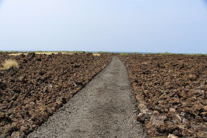
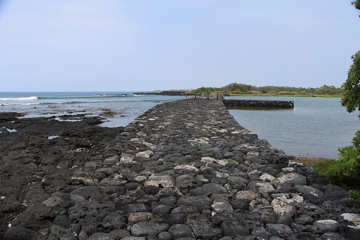
On commence pour nous rendre au Kaloko-Honokōhau National Historical Park, un grand parc avec 3 entrées. On se stationne à l'entrée principale, le temps de récupérer une brochure au Visitor Center et de comprendre le système des divisions parcellaires. Ensuite, on se lance dans une petite boucle qui doit nous amener à un fish pond qu'il est intéressant d'aller découvrir.
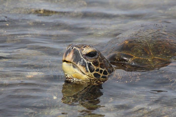
Il est encore tôt, l'air est frais, c'est donc très agréable. Assez rapidement nous atteignons le bord de mer où la marée basse découvre de nombreux rochers. On scrute les environs, car les lieux sont réputés pour être un repère de tortues et on ne tarde pas à en repérer plusieurs qui dorment sur les rochers. On les approche, on les photographie, quand on remarque un truc bouger dans l'eau. Tien, une autre tortue! On ne l'avait pas du tout remarqué car la carapace lisse faisait vraiment penser à une gros galet. Cette vision nous amène à la déduction suivante: mais si les autres gros galets n'étaient pas aussi des tortues? Bingo!

D'un coup, toutes les pierres des petits bassins d'eau deviennent des tortues, c'est complètement fou! Il y a quelques minutes, on en avait repéré 3, et maintenant, en voilà une dizaine au même endroit!

On passe un bon moment à les observer, puis on avance le long de la plage. Sur le chemin on en croisera d'autres, toujours en train de dormir ;) Finalement, la balade devait être assez courte, mais avec tous ces arrêts tortues, on y passe beaucoup de temps, tellement que l'heure avance et qu'il nous faut accélérer le pas car d'autres endroits sont encore à découvrir aujourd'hui.
On croise une dame du coin qui fait un bout de chemin avec nous. Elle nous raconte plein de trucs sur sa vie locale et également que selon elle, il nous sera plus rapide d'atteindre le fish pond en revenant à la voiture, plutôt qu'en faisant le grand aller-retour à pied, mais que le sentier qui coupe pour retourner au parking est très chaud et "streneous" (épuisant), et qu'il vaut mieux ne pas l'emprunter.
Interloqués, on pense qu'elle délire un peu, car il fait certes un peu plus chaud, mais l'air est toujours agréable. On passe alors devant le début du sentier qui nous ne semble pas du tout difficile, bien tracé et tout plat. Du coup, on l'abandonne et on se dirige sur le sentier.
Après 5 minutes de marche on commence à comprendre! La température a du grimper de 10 degrés, il n'y a plus d'air, on crève de chaud et la voiture semble encore super loin! Finalement, elle n'avait pas tort! Le pourquoi? Le sentier traverse une coulée de lave. Il n'y a aucune ombre, le vent de la mer n'est plus là pour nous refroidir et le soleil tape de toutes ses forces sur les rochers noirs. On a l'impression d'être sur un barbecue géant!

Les 30 minutes qui suivront nous sembleront interminables! J'ai transpiré comme jamais! Heureusement qu'on avait un peu d'eau, sinon ça aurait pu mal terminer.
Le temps de se rafraîchir un peu, on reprend la route pour rejoindre le fish pond qui est finalement beaucoup plus facilement accessible depuis une autre entrée du parc qui n'était pas bien signalée au bord de la route.

On fait l'aller retour, puis on reprend la voiture pour aller chercher de quoi manger. On fait un bref arrêt à une station service pour prendre des hot dog et on se dirige vers la mer, à Mahai'ula beach.
La route pour y accéder est complètement défoncée! On croise quelques véhicules de tourisme progressant à 5 km/h (ça ne devait pas être marrant pour eux). Heureusement, notre 4x4 nous permet d'avancer beaucoup plus vite, mais en étant ballotés dans tous les sens.
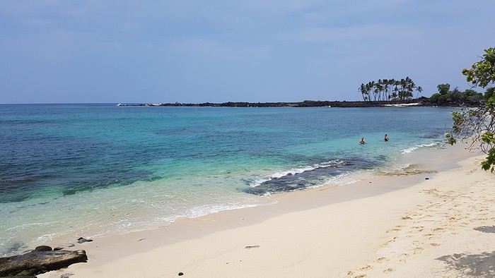
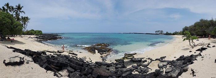
Le parking est bien plein, nous craignons de trouver beaucoup de monde sur le sable. On laisse la voiture et on emprunte sur quelques centaines de mètres un sentier qui nous amènera au bord de l'eau. On découvre alors une sublime plage au sable blanc et à l'eau turquoise et avec quasiment personne. Si ça, ça n'est pas une incitation à la baignade!


Mais avant de plus en profiter, on dévore notre repas. Qu'est ce qu'on est bien ici! Plus tard, on se rendra compte qu'on a raté la plage voisine de Makalawena Beach qui était apparement encore plus belle :( Encore un truc à rajouter à la to do list pour le prochain voyage!
La journée avance et il ne nous reste plus que 2h avant de nous rendre à l'aéroport. Du coup on poursuit la route au nord et on décide d'aller jeter un oeil à Kiholo bay. On pensait à tort pouvoir s'en rapprocher davantage en voiture, mais en fait il faut marcher pendant bien 45min pour atteindre le début de la baie.
Il est 14h30, le ciel se dégage et le soleil cogne de toutes ses forces. On marche dans le sable mou, ce qui est épuisant et après nos crapahutages du matin, nous ne sommes plus très frais. La balade n'est vraiment pas une partie de plaisir.

L'heure avançant, nous n'avons pas le temps d'atteindre le petit lagon ni les zones de baignade. Notre seule option, aller faire un tour en drone pour voir du ciel ce que nous n'aurons pas le temps d'approcher. C'est dommage car les couleurs sont superbes (à voir dans la vidéo), et en plus il n'y a vraiment personne! Encore un truc à rajouter à la to do list!
On regagne la voiture à nouveau trempés de sueur, contents d'avoir la clim pour nous refroidir et nous dire qu'on sera bien au frais à l'aéroport en attendant l'avion.
Raté!! On avait complètement oublié que l'aéroport de Kona est en plein air... et qu'il n'y a du coup, pas de clim! Il fait plus de 30 degrés et on attend notre avion... au chaud! Notre petit ATR arrive et déception, on est obligé de mettre notre sac photo/drone en soute. On est pas du tout rassurés...
Après seulement 25 minutes de vol (c'est super rapide!) on arrive à Maui, à Kahului. Finalement on récupère notre sac photo en bon état au pied de l'avion. Direction le loueur de voiture où on récupère une petite Nissan Versa un peu cabossée. Il est 18h30, on file alors vers le nord-ouest de l'île jusqu'à notre condo situé à Napili-Honokowai.
L'appart est super sympa, situé à 30 mètres de la mer avec une piscine au bord de l'océan. Le rêve! A peine nos valises posées, on enfile nos maillots pour se jeter à l'eau!
Et voici la vidéo! youtu.be/2LNuI-Cx_No
Vous remarquerez qu'on est de plus en plus à l'aise devant la caméra 😄
Un nouveau jour se lève sur Big Island. Le temps est toujours brumeux mais la météo devrait s'améliorer dans la journée. Il est temps pour nous de remballer nos affaires car ce soir nous quittons l'île pour nous rendre à Maui.
L'aéroport étant situé au nord de Kona, nous resterons dans les parages pour pouvoir facilement nous y rendre en fin de journée.
On commence pour nous rendre au Kaloko-Honokōhau National Historical Park, un grand parc avec 3 entrées. On se stationne à l'entrée principale, le temps de récupérer une brochure au Visitor Center et de comprendre le système des divisions parcellaires. Ensuite, on se lance dans une petite boucle qui doit nous amener à un fish pond qu'il est intéressant d'aller découvrir.
Il est encore tôt, l'air est frais, c'est donc très agréable. Assez rapidement nous atteignons le bord de mer où la marée basse découvre de nombreux rochers. On scrute les environs, car les lieux sont réputés pour être un repère de tortues et on ne tarde pas à en repérer plusieurs qui dorment sur les rochers. On les approche, on les photographie, quand on remarque un truc bouger dans l'eau. Tien, une autre tortue! On ne l'avait pas du tout remarqué car la carapace lisse faisait vraiment penser à une gros galet. Cette vision nous amène à la déduction suivante: mais si les autres gros galets n'étaient pas aussi des tortues? Bingo!

D'un coup, toutes les pierres des petits bassins d'eau deviennent des tortues, c'est complètement fou! Il y a quelques minutes, on en avait repéré 3, et maintenant, en voilà une dizaine au même endroit!

On passe un bon moment à les observer, puis on avance le long de la plage. Sur le chemin on en croisera d'autres, toujours en train de dormir ;) Finalement, la balade devait être assez courte, mais avec tous ces arrêts tortues, on y passe beaucoup de temps, tellement que l'heure avance et qu'il nous faut accélérer le pas car d'autres endroits sont encore à découvrir aujourd'hui.
On croise une dame du coin qui fait un bout de chemin avec nous. Elle nous raconte plein de trucs sur sa vie locale et également que selon elle, il nous sera plus rapide d'atteindre le fish pond en revenant à la voiture, plutôt qu'en faisant le grand aller-retour à pied, mais que le sentier qui coupe pour retourner au parking est très chaud et "streneous" (épuisant), et qu'il vaut mieux ne pas l'emprunter.
Interloqués, on pense qu'elle délire un peu, car il fait certes un peu plus chaud, mais l'air est toujours agréable. On passe alors devant le début du sentier qui nous ne semble pas du tout difficile, bien tracé et tout plat. Du coup, on l'abandonne et on se dirige sur le sentier.
Après 5 minutes de marche on commence à comprendre! La température a du grimper de 10 degrés, il n'y a plus d'air, on crève de chaud et la voiture semble encore super loin! Finalement, elle n'avait pas tort! Le pourquoi? Le sentier traverse une coulée de lave. Il n'y a aucune ombre, le vent de la mer n'est plus là pour nous refroidir et le soleil tape de toutes ses forces sur les rochers noirs. On a l'impression d'être sur un barbecue géant!

Les 30 minutes qui suivront nous sembleront interminables! J'ai transpiré comme jamais! Heureusement qu'on avait un peu d'eau, sinon ça aurait pu mal terminer.
Le temps de se rafraîchir un peu, on reprend la route pour rejoindre le fish pond qui est finalement beaucoup plus facilement accessible depuis une autre entrée du parc qui n'était pas bien signalée au bord de la route.

On fait l'aller retour, puis on reprend la voiture pour aller chercher de quoi manger. On fait un bref arrêt à une station service pour prendre des hot dog et on se dirige vers la mer, à Mahai'ula beach.
La route pour y accéder est complètement défoncée! On croise quelques véhicules de tourisme progressant à 5 km/h (ça ne devait pas être marrant pour eux). Heureusement, notre 4x4 nous permet d'avancer beaucoup plus vite, mais en étant ballotés dans tous les sens.
Le parking est bien plein, nous craignons de trouver beaucoup de monde sur le sable. On laisse la voiture et on emprunte sur quelques centaines de mètres un sentier qui nous amènera au bord de l'eau. On découvre alors une sublime plage au sable blanc et à l'eau turquoise et avec quasiment personne. Si ça, ça n'est pas une incitation à la baignade!


Mais avant de plus en profiter, on dévore notre repas. Qu'est ce qu'on est bien ici! Plus tard, on se rendra compte qu'on a raté la plage voisine de Makalawena Beach qui était apparement encore plus belle :( Encore un truc à rajouter à la to do list pour le prochain voyage!
La journée avance et il ne nous reste plus que 2h avant de nous rendre à l'aéroport. Du coup on poursuit la route au nord et on décide d'aller jeter un oeil à Kiholo bay. On pensait à tort pouvoir s'en rapprocher davantage en voiture, mais en fait il faut marcher pendant bien 45min pour atteindre le début de la baie.
Il est 14h30, le ciel se dégage et le soleil cogne de toutes ses forces. On marche dans le sable mou, ce qui est épuisant et après nos crapahutages du matin, nous ne sommes plus très frais. La balade n'est vraiment pas une partie de plaisir.

L'heure avançant, nous n'avons pas le temps d'atteindre le petit lagon ni les zones de baignade. Notre seule option, aller faire un tour en drone pour voir du ciel ce que nous n'aurons pas le temps d'approcher. C'est dommage car les couleurs sont superbes (à voir dans la vidéo), et en plus il n'y a vraiment personne! Encore un truc à rajouter à la to do list!
On regagne la voiture à nouveau trempés de sueur, contents d'avoir la clim pour nous refroidir et nous dire qu'on sera bien au frais à l'aéroport en attendant l'avion.
Raté!! On avait complètement oublié que l'aéroport de Kona est en plein air... et qu'il n'y a du coup, pas de clim! Il fait plus de 30 degrés et on attend notre avion... au chaud! Notre petit ATR arrive et déception, on est obligé de mettre notre sac photo/drone en soute. On est pas du tout rassurés...
Après seulement 25 minutes de vol (c'est super rapide!) on arrive à Maui, à Kahului. Finalement on récupère notre sac photo en bon état au pied de l'avion. Direction le loueur de voiture où on récupère une petite Nissan Versa un peu cabossée. Il est 18h30, on file alors vers le nord-ouest de l'île jusqu'à notre condo situé à Napili-Honokowai.
L'appart est super sympa, situé à 30 mètres de la mer avec une piscine au bord de l'océan. Le rêve! A peine nos valises posées, on enfile nos maillots pour se jeter à l'eau!
Et voici la vidéo! youtu.be/2LNuI-Cx_No
Vous remarquerez qu'on est de plus en plus à l'aise devant la caméra 😄
Retrouvez-nous sur --> https://www.smartrippers.com
USA/Hawaii: 2000, 2012, 2013, 2014, 2017, 2018, 2019
Islande: 2016, 2018, 2020
Japon: 2010, 2015, 2018
1er tour du monde 2019: Polynésie, Hawaii, Nouvelle-Zélande, Singapour et Bali
Quelle chance vous avez eue de voir toutes ces tortues. Pour notre dernière journée à Kona et par le fait même la fin de notre voyage, nous nous sommes reposés et sommes allés sur une plage faire du snorkeling et relaxer. La température frisait les 40° avec humidex . Rien pour nous donner envie de marcher. Faut dire que la veille, plutôt que de boire beaucoup d'eau à notre descente du Mauna Kea, on a pris un bon dîner au restaurant avec un mai tai. J'ai tout rendu dans la nuit🤪.
J'ai trouvé qu'il faisait vraiment très chaud à Hawaï. Nous avons souffert à Oahu, à Diamond Head et sur la Kalalau Trail à Kauai. Presque heureux d'avoir 19° seulement ce week-end au Québec.😉
Mon dieu, 40 degrés! Je comprends que l'envie de marcher vous soit passée! La région de Kona est vraiment très chaude et presque désertique. C'est vrai que l'été est beaucoup plus chaud. A la mi-saison c'était pas mal finalement 😉
Retrouvez-nous sur --> https://www.smartrippers.com
USA/Hawaii: 2000, 2012, 2013, 2014, 2017, 2018, 2019
Islande: 2016, 2018, 2020
Japon: 2010, 2015, 2018
1er tour du monde 2019: Polynésie, Hawaii, Nouvelle-Zélande, Singapour et Bali
Allô! Sandrine
Difficile de choisir la bonne période pour visiter Hawaï. J'avais choisi l'été pour éviter les pluies et nous n'en avons presque pas eu, même à Hilo. Je voulais aussi éviter l'hiver pour profiter d'une mer plus calme. Peut-être que le printemps ou l'automne sont les saisons idéales.
La météo est un peu comme la loterie. Visiblement le mois de juillet a été assez pluvieux sur l'archipel cette année, le mois d'août plus sec, et de notre côté nous avons eu en général un très beau temps sur l'ensemble du voyage avec seulement 3 jours de pluie et encore, ça n'a duré que quelques heures à chaque fois. Mais d'après les locaux, c'était un temps exceptionnel.
L'hiver il y a les baleines et les vagues, l'été il y a plus de monde, il fait plus chaud mais la mer est calme. Je pense que chaque saison à ces avantages et inconvénients 😉 Mais peut-être moins de risque aux mi-saisons.
Retrouvez-nous sur --> https://www.smartrippers.com
USA/Hawaii: 2000, 2012, 2013, 2014, 2017, 2018, 2019
Islande: 2016, 2018, 2020
Japon: 2010, 2015, 2018
1er tour du monde 2019: Polynésie, Hawaii, Nouvelle-Zélande, Singapour et Bali
Toujours un régal de voir ces vidéos 🙂.
C'est drôle, nous n'avons pas vu beaucoup de tortue sur Big Island par rapport à vous alors qu'à Mauï beaucoup, beaucoup plus 😉.
Il est vrai que quelque fois, nous allons au delà de nos forces mais quand on voit ces magnifiques plages, l'effort est mille fois récompensé 🙂 et que de souvenirs...
Sympa de finir cette journée dans la piscine.
"Voyager est un triple plaisir : l'attente, l'éblouissement et le souvenir." Ilka Chase
Je rédigerai prochainement sur notre site un article complet qui détaillera l'ensemble de notre budget ainsi que le coût de la vie poste par poste à Hawaii.
Je commence à regarder pour les véhicules et pour une Jeep Wrangler, je suis à 385 euros pour 7 jours avec toutes les assurances et le rachat de franchise. Est-ce un prix correct? J'ai vu que vous aviez réservé le véhicule découverte et qu'on vous avait proposé un minivan. Mais si quelqu'un peut me renseigner.
C'est marrant car nous c'était l'inverse! On a vu qu'une seule tortue à Maui alors qu'on en a vu plein sur les autres îles. Comme quoi ;)
Et oui, je te confirme, la piscine c'est vraiment trop bien! Dommage car on a pas pu en profiter beaucoup :(
Retrouvez-nous sur --> https://www.smartrippers.com
USA/Hawaii: 2000, 2012, 2013, 2014, 2017, 2018, 2019
Islande: 2016, 2018, 2020
Japon: 2010, 2015, 2018
1er tour du monde 2019: Polynésie, Hawaii, Nouvelle-Zélande, Singapour et Bali
Log in first, then come back to this page.
You might also like
More discussions
Namaste!
Here I am live from Delhi, past midnight, at least 30 degrees....
I wanted to post the start of this France travel journal but couldn’t find the time, so here it is live!
Off we go for a third trip, but this time for double the duration—6 weeks with the goal of discovering Ladakh and Spiti, starting with a detour to Varanasi to meet up with Babeli and her family.
Phir milenge for the rest of the adventures...
Wednesday, April 1st
Hazaribagh I’ve got a meet-up with Adam Iman, a guide and painter. He picks me up from the hotel at 10 AM. Another traveler from Bangalore is supposed to join us, but while we wait for him to arrive, Adam takes me to see the paintings his mother and sister created at Hazaribagh station. The town became famous thanks to these murals, which can also be found in several surrounding villages. This art form has earned recognition and is now protected, a sign of its cultural importance. Once the visit is over, we go to pick up the other traveler and then head to our first village: Belwara, where Sohrai art is practiced. At the entrance, a sign proudly announces that we’re entering an artists’ village, where this art is created by women organized into micro-enterprises. Some even offer workshops for those who’d like to learn this tradition.

Sohrai art is tied to the harvest season, from October to mid-November. The motifs, in natural colors, celebrate fertility and abundance. The artists use pigments from the earth: red oxides, ochre, white kaolin, and black manganese. On the walls, you’ll see animals, fish, birds—all symbols of life and prosperity. As I look closer at the murals, I start to realize that each motif tells a story. Large animals like cows or bulls often take center stage. Their bodies are filled with intricate, almost hypnotic patterns. They symbolize wealth and prosperity for the household, as well as the deep respect for cattle, which are essential to daily life. On some facades, elephants stand out—massive and decorated with the same precision. They evoke quiet strength and protection. But it’s when I stop in front of one of the houses that I really take the time to look. The wall, a soft ochre, is entirely covered in murals. Two large animals stretch out on either side of the door, their elongated bodies fitting the length of the wall. Their silhouettes are filled with geometric patterns and incredibly fine curved lines, as if every space was patiently filled. Around them, stylized plants, flowers, and small decorative elements fill every gap. The door, dark and worn, becomes almost the silent center of the composition, framed by these living, protective forms. To the right, a more colorful motif catches the eye—a flower or a stylized lamp—like a touch of light on the earth. The whole thing gives an impression of perfect balance, between the rigor of the patterns and the freedom of the gesture.

Elsewhere, birds and freer forms bring movement. Peacocks, recognizable by their stylized silhouettes, embody beauty and vitality, while fish symbolize water, fertility, and the continuity of life.
On some paintings, the scenes become almost narrative: you can make out figures, everyday gestures, like a memory of the village inscribed in the walls. The decorative frames around the doors aren’t left to chance either—they symbolically protect the house, like a boundary between the inside and the outside world.
During the Sohrai festival, cattle are led into the jungle in the morning. Meanwhile, the women finish the *aripans*—these floor paintings—and continue the wall murals. Around noon, the animals return to the village, and the bulls’ horns are anointed with oil and vermilion in a gesture of gratitude, amid the vibrant colors adorning the houses. We visit several artists, including Parvat Devi, a well-known woman who has received many awards. Her arms are adorned with intriguing tattoos, which I’ll talk about in more detail later.

On another wall, the style changes completely. Here, no massive animals—just birds occupying the space, light and graceful, as if caught in mid-movement. Two silhouettes face each other, their long necks arched almost like mirrors, while their outstretched wings seem to vibrate with the patterns that compose them.

The design is more graphic, almost airy. The lines are smoother, more fluid, as if drawn in one confident stroke. The birds’ bodies aren’t solid—they’re filled with repetitive motifs like scales, stylized feathers, and spirals, giving a sense of continuous movement. Around them, everything comes to life: flowers burst open, arabesques swirl, and even the simplest shapes seem alive. What strikes me here is the sense of lightness. Where the large animals evoked stability and grounding, these birds bring something freer, almost joyful. They seem to embody movement, the circulation of life, like a breath flowing through the village.

The colors remain the same—deep reds, intense blacks, and chalky white—but the rhythm is different. Faster, more spontaneous. As if each wall had its own personality, while still speaking the same language.
That’s probably why I’m so moved. I’d heard about these paintings from my friend Raja, and last year, I saw an exhibition in a village near my home. That first encounter made me want to come here. But seeing them in person is a whole different experience. These paintings are unique. This ancient art is passed down from mother to daughter, or mother-in-law to daughter-in-law, in a quiet, deeply living continuity. At first glance, it might seem almost childlike in its simplicity and pared-down forms. And yet, everything is thought out, balanced, mastered. Nothing is left to chance.

That apparent simplicity, combined with such rich symbolism, touches me deeply. There’s something sincere and essential in these walls—and that’s what moves me.
Hazaribagh I’ve got a meet-up with Adam Iman, a guide and painter. He picks me up from the hotel at 10 AM. Another traveler from Bangalore is supposed to join us, but while we wait for him to arrive, Adam takes me to see the paintings his mother and sister created at Hazaribagh station. The town became famous thanks to these murals, which can also be found in several surrounding villages. This art form has earned recognition and is now protected, a sign of its cultural importance. Once the visit is over, we go to pick up the other traveler and then head to our first village: Belwara, where Sohrai art is practiced. At the entrance, a sign proudly announces that we’re entering an artists’ village, where this art is created by women organized into micro-enterprises. Some even offer workshops for those who’d like to learn this tradition.

Sohrai art is tied to the harvest season, from October to mid-November. The motifs, in natural colors, celebrate fertility and abundance. The artists use pigments from the earth: red oxides, ochre, white kaolin, and black manganese. On the walls, you’ll see animals, fish, birds—all symbols of life and prosperity. As I look closer at the murals, I start to realize that each motif tells a story. Large animals like cows or bulls often take center stage. Their bodies are filled with intricate, almost hypnotic patterns. They symbolize wealth and prosperity for the household, as well as the deep respect for cattle, which are essential to daily life. On some facades, elephants stand out—massive and decorated with the same precision. They evoke quiet strength and protection. But it’s when I stop in front of one of the houses that I really take the time to look. The wall, a soft ochre, is entirely covered in murals. Two large animals stretch out on either side of the door, their elongated bodies fitting the length of the wall. Their silhouettes are filled with geometric patterns and incredibly fine curved lines, as if every space was patiently filled. Around them, stylized plants, flowers, and small decorative elements fill every gap. The door, dark and worn, becomes almost the silent center of the composition, framed by these living, protective forms. To the right, a more colorful motif catches the eye—a flower or a stylized lamp—like a touch of light on the earth. The whole thing gives an impression of perfect balance, between the rigor of the patterns and the freedom of the gesture.

Elsewhere, birds and freer forms bring movement. Peacocks, recognizable by their stylized silhouettes, embody beauty and vitality, while fish symbolize water, fertility, and the continuity of life.
On some paintings, the scenes become almost narrative: you can make out figures, everyday gestures, like a memory of the village inscribed in the walls. The decorative frames around the doors aren’t left to chance either—they symbolically protect the house, like a boundary between the inside and the outside world.

During the Sohrai festival, cattle are led into the jungle in the morning. Meanwhile, the women finish the *aripans*—these floor paintings—and continue the wall murals. Around noon, the animals return to the village, and the bulls’ horns are anointed with oil and vermilion in a gesture of gratitude, amid the vibrant colors adorning the houses. We visit several artists, including Parvat Devi, a well-known woman who has received many awards. Her arms are adorned with intriguing tattoos, which I’ll talk about in more detail later.

On another wall, the style changes completely. Here, no massive animals—just birds occupying the space, light and graceful, as if caught in mid-movement. Two silhouettes face each other, their long necks arched almost like mirrors, while their outstretched wings seem to vibrate with the patterns that compose them.

The design is more graphic, almost airy. The lines are smoother, more fluid, as if drawn in one confident stroke. The birds’ bodies aren’t solid—they’re filled with repetitive motifs like scales, stylized feathers, and spirals, giving a sense of continuous movement. Around them, everything comes to life: flowers burst open, arabesques swirl, and even the simplest shapes seem alive. What strikes me here is the sense of lightness. Where the large animals evoked stability and grounding, these birds bring something freer, almost joyful. They seem to embody movement, the circulation of life, like a breath flowing through the village.

The colors remain the same—deep reds, intense blacks, and chalky white—but the rhythm is different. Faster, more spontaneous. As if each wall had its own personality, while still speaking the same language.
That’s probably why I’m so moved. I’d heard about these paintings from my friend Raja, and last year, I saw an exhibition in a village near my home. That first encounter made me want to come here. But seeing them in person is a whole different experience. These paintings are unique. This ancient art is passed down from mother to daughter, or mother-in-law to daughter-in-law, in a quiet, deeply living continuity. At first glance, it might seem almost childlike in its simplicity and pared-down forms. And yet, everything is thought out, balanced, mastered. Nothing is left to chance.

That apparent simplicity, combined with such rich symbolism, touches me deeply. There’s something sincere and essential in these walls—and that’s what moves me.
Hi everyone, I’m Patrick, 67 years old, a seasoned traveler (already 22 trips outside Europe).
In autumn 2025, I took my first 3-week trip to Japan, with stops in Tokyo, Kamakura, Matsumoto, Kamikochi, Takayama, Kanazawa, Kyoto, Nara, Osaka, Koyasan, Tokyo again, and Nikko.
I wanted to go back in May 2026 and explore some lesser-known places to complement my first trip.
Last year, there were four of us traveling together to discover Japan (a fairly classic itinerary). This time, I’ll be traveling solo for part of the trip and with a couple of French friends for the rest.
The weather was gorgeous in May, averaging around 25°C, with two very hot days in Kyoto and only two rainy days.
As usual, I organized everything myself, gathering plenty of information from various sites, including this one.
Transportation: An ICOCA card is essential. I got a 5-day Kansai-Hiroshima pass because I took the shinkansen between Hiroshima and Osaka three times, and it paid for itself quickly.
Accommodations: Mostly through Booking. No issues at all. Average cost was 46 € per night.
Meals: For breakfast, I alternated between buying food at a konbini to eat in my room or on the train and grabbing something at local cafés. For lunch and dinner, I tried to vary my meals as much as possible—lots of sashimi, sushi, and ramen. Okonomiyaki in Osaka and Hiroshima. Oysters in every form (raw, grilled, fried) in Onomichi and Hiroshima. A variety of seafood (shrimp, shellfish) in Hiroshima and Matsumoto. Fish whose names often escaped me, but notably mackerel and eel (unagi). Tempura and gyoza. Chicken skewers (yakitori) and one teppanyaki meal. One omakase meal (9 different dishes). In the end, not much meat aside from a few yakitori skewers. No splurges on super expensive wagyu or Kobe beef. Average dinner cost: 4,800 yen, drinks included.
The Itinerary: Day 1: Departure from Brussels Day 2: Arrival in Osaka Day 3: To Himeji, then Kurashiki Day 4: To Fukuyama, then Tomo no Ura, then Onomichi Day 5: Cycling the Shimanami Kaido Day 6: To Takahara, then Hiroshima Day 7: To Kyoto to attend the Aoi Matsuri parade Day 8: To Miyajima Day 9: Hiroshima, then Kyoto Day 10: Southern Kyoto Day 11: Northern Kyoto Day 12: Final day in Kyoto, then to Nagatsugawa Day 13: Start of the Nakasendo Trail (Magome to Tsumago) Day 14: Second day of the trail (Kiso Fukushima) Day 15: Third day of the trail (Narai), then Matsumoto Day 16: To Mt. Fuji (Kawaguchiko) Day 17: To Tokyo Day 18: Excursion to Enoshima and Kamakura Day 19: Flight home, with a 10-hour layover in Hong Kong Day 20: Arrival in Brussels
Transportation: An ICOCA card is essential. I got a 5-day Kansai-Hiroshima pass because I took the shinkansen between Hiroshima and Osaka three times, and it paid for itself quickly.
Accommodations: Mostly through Booking. No issues at all. Average cost was 46 € per night.
Meals: For breakfast, I alternated between buying food at a konbini to eat in my room or on the train and grabbing something at local cafés. For lunch and dinner, I tried to vary my meals as much as possible—lots of sashimi, sushi, and ramen. Okonomiyaki in Osaka and Hiroshima. Oysters in every form (raw, grilled, fried) in Onomichi and Hiroshima. A variety of seafood (shrimp, shellfish) in Hiroshima and Matsumoto. Fish whose names often escaped me, but notably mackerel and eel (unagi). Tempura and gyoza. Chicken skewers (yakitori) and one teppanyaki meal. One omakase meal (9 different dishes). In the end, not much meat aside from a few yakitori skewers. No splurges on super expensive wagyu or Kobe beef. Average dinner cost: 4,800 yen, drinks included.
The Itinerary: Day 1: Departure from Brussels Day 2: Arrival in Osaka Day 3: To Himeji, then Kurashiki Day 4: To Fukuyama, then Tomo no Ura, then Onomichi Day 5: Cycling the Shimanami Kaido Day 6: To Takahara, then Hiroshima Day 7: To Kyoto to attend the Aoi Matsuri parade Day 8: To Miyajima Day 9: Hiroshima, then Kyoto Day 10: Southern Kyoto Day 11: Northern Kyoto Day 12: Final day in Kyoto, then to Nagatsugawa Day 13: Start of the Nakasendo Trail (Magome to Tsumago) Day 14: Second day of the trail (Kiso Fukushima) Day 15: Third day of the trail (Narai), then Matsumoto Day 16: To Mt. Fuji (Kawaguchiko) Day 17: To Tokyo Day 18: Excursion to Enoshima and Kamakura Day 19: Flight home, with a 10-hour layover in Hong Kong Day 20: Arrival in Brussels
This trip had been on my mind for about fifteen years.
But the discomfort of overnight stays, the difficulty of communication, and the prices of the few car rentals kept making me postpone the project.
And then, everything fell into place—I told myself, now’s the time!
Preparations took longer than usual; the destination is still far from mainstream.
A bit of Kazakhstan? Not in the end.
The south or not? Yes, in the end.
Pre-book or play it by ear? Only two stops were a leap into the unknown.
To help me find the ideal route, I made great use of this forum (thanks to everyone for patiently answering my questions!), pored over travel journals and blogs (Christian, Jeff), zoomed in on Google Maps and Yandex, and bought the guide published by OunTravela on this destination (the guide has been updated since).
---/---
You’ve got your passport, international driver’s license, bank cards, and euros?
Off we go to Lyon—just one night left before our early morning flight.
Tomorrow night, we’ll be sleeping in Bishkek! (‘Beefsteak’ for my partner’s mischievous nephews...)

You’ll find here a post with some practical info.
But the discomfort of overnight stays, the difficulty of communication, and the prices of the few car rentals kept making me postpone the project.
And then, everything fell into place—I told myself, now’s the time!
Preparations took longer than usual; the destination is still far from mainstream.
A bit of Kazakhstan? Not in the end.
The south or not? Yes, in the end.
Pre-book or play it by ear? Only two stops were a leap into the unknown.
To help me find the ideal route, I made great use of this forum (thanks to everyone for patiently answering my questions!), pored over travel journals and blogs (Christian, Jeff), zoomed in on Google Maps and Yandex, and bought the guide published by OunTravela on this destination (the guide has been updated since).
---/---
You’ve got your passport, international driver’s license, bank cards, and euros?
Off we go to Lyon—just one night left before our early morning flight.
Tomorrow night, we’ll be sleeping in Bishkek! (‘Beefsteak’ for my partner’s mischievous nephews...)

You’ll find here a post with some practical info.
Day 1 – February 14
We all have two lives. And the second one kicks off the day you realize you only have one, with the determination to spend the time you have left on what truly adds sparkle to your life, Kevin! I like to elegantly introduce a trip with a philosophical quote. First, it gives you the illusion that I’m some kind of deep thinker, and second, it lets me fill up the first few lines of my blank page when I don’t know how to tell you I’m diving back into what really lights up my life: another adventure beyond the horizon! And nearly every other year, like a toxic relationship, my horizon tends to take shape in Uncle Sam’s backyard. And this, despite his cousin Donald calling the shots. Speaking of which, it was partly that impulsive guy who pushed us to be just as impulsive and snag our four flight tickets at a ridiculously low price—a direct result of foreign tourism taking a hit from BetaMax’s repeated antics... Four tickets? Who are the other lucky ones? In this case, our lucky ones are actually lucky ladies: My Flo, always up for exploring the world with me on foot, camelback, or scooter, is obviously in on the fun. The other two seats went to our daughters, Sasha and Luna, both thrilled to be part of this new American adventure...
But what’s the American West like in February?... A gamble. Let’s call it Russian roulette since we’re not landing during peak weather season. That’s why we encouraged our transportation and accommodation to get cozy and produce a little camper van, so we can stay ultra-flexible in the face of any weather tantrums. We’ll be roaming in Kara the van with the motto "Follow the sun!" Bad weather? We bolt. Snow? We speed up. Sunny? We act like it was the plan all along and soak it up.
"Okay, but why keep coming back to the same corner of the globe? After ten American adventures, you must be tired of seeing the same things, right?" But I’m not crazy, you know!... The American West is like making love to your gorgeous wife over and over, always enjoying it just as much. And contrary to what you might think, the American West isn’t just the Grand Canyon, Monument Valley, Las Vegas, and Bryce Canyon. Proof is, after ten trips to the U.S., my retinas are still untouched by three-quarters of the places I scribbled on a napkin for this adventure... Oh, and add to that my wife, who I’ve easily converted to my religion, and boom... relapse is even easier! Because yes, we’ve landed in Los Angeles after a sunny flight over Greenland, still under Danish flag for now. And we’re already heading east through the XXL traffic of L.A.’s eight-lane highways, eager to dive into our first discoveries. But first, night is taking over the sky, and second, we’ve been officially awake for 24 hours, so I suggest wrapping up this intro. I’ll tell you more tomorrow morning. Sound good?


We all have two lives. And the second one kicks off the day you realize you only have one, with the determination to spend the time you have left on what truly adds sparkle to your life, Kevin! I like to elegantly introduce a trip with a philosophical quote. First, it gives you the illusion that I’m some kind of deep thinker, and second, it lets me fill up the first few lines of my blank page when I don’t know how to tell you I’m diving back into what really lights up my life: another adventure beyond the horizon! And nearly every other year, like a toxic relationship, my horizon tends to take shape in Uncle Sam’s backyard. And this, despite his cousin Donald calling the shots. Speaking of which, it was partly that impulsive guy who pushed us to be just as impulsive and snag our four flight tickets at a ridiculously low price—a direct result of foreign tourism taking a hit from BetaMax’s repeated antics... Four tickets? Who are the other lucky ones? In this case, our lucky ones are actually lucky ladies: My Flo, always up for exploring the world with me on foot, camelback, or scooter, is obviously in on the fun. The other two seats went to our daughters, Sasha and Luna, both thrilled to be part of this new American adventure...
But what’s the American West like in February?... A gamble. Let’s call it Russian roulette since we’re not landing during peak weather season. That’s why we encouraged our transportation and accommodation to get cozy and produce a little camper van, so we can stay ultra-flexible in the face of any weather tantrums. We’ll be roaming in Kara the van with the motto "Follow the sun!" Bad weather? We bolt. Snow? We speed up. Sunny? We act like it was the plan all along and soak it up.
"Okay, but why keep coming back to the same corner of the globe? After ten American adventures, you must be tired of seeing the same things, right?" But I’m not crazy, you know!... The American West is like making love to your gorgeous wife over and over, always enjoying it just as much. And contrary to what you might think, the American West isn’t just the Grand Canyon, Monument Valley, Las Vegas, and Bryce Canyon. Proof is, after ten trips to the U.S., my retinas are still untouched by three-quarters of the places I scribbled on a napkin for this adventure... Oh, and add to that my wife, who I’ve easily converted to my religion, and boom... relapse is even easier! Because yes, we’ve landed in Los Angeles after a sunny flight over Greenland, still under Danish flag for now. And we’re already heading east through the XXL traffic of L.A.’s eight-lane highways, eager to dive into our first discoveries. But first, night is taking over the sky, and second, we’ve been officially awake for 24 hours, so I suggest wrapping up this intro. I’ll tell you more tomorrow morning. Sound good?


March 2nd — Departure by bus from Latour at 6:50 AM. The journey isn’t direct: we pass through Elne then Corneilla. In Perpignan, I switch to a BlablaBus heading to Barcelona’s northern bus station. Before reaching Le Perthus, French police stop us to check IDs. Several people aren’t in order, but after about fifteen minutes, we’re on our way again. We’re checked again at La Jonquera: this time, the wait lasts almost forty-five minutes while police identify those in violation and wait for a vehicle to pick them up. The driver then tries to make up for lost time; we finally arrive at our destination half an hour late.
I quickly head to the Arc de Triomphe metro station, located 200 meters away: you have to cross the bridge along the bus parking lot, then walk through a large garden; the station is on the right before the garden entrance. The trip to the airport isn’t direct: I have to change at Tomasso and take the line to the airport, where I arrive at 1 PM.
At the Emirates counter, I learn my flight was just canceled due to the war in Iran; they offer me another flight for the next day. I have to wait at the airport until 7 PM before being taken to a hotel; the next morning, I’ll take a flight to Vienna (with an 8-hour layover), then an Air India flight to Delhi, and finally a flight to Kolkata. I agree: I don’t know Vienna, so it’ll be an unexpected discovery.
At 7 PM, a small group is taken to the hotel, 35 minutes from the airport, where we’re served a light dinner upon arrival.
March 3rd — A taxi picks me up at 6:30 AM; the flight to Vienna takes off at 9:30 AM and arrives at noon. I’m free until 7 PM; the metro is direct to the city center. The weather is pleasant and not too cold, luckily, since my clothes are light.
When I exit the metro, I spot the St. Stephen’s Cathedral tower in the distance and approach it: the roof, made of glazed tiles, is remarkable.

Entry is free, and the interior, a mix of Gothic and Baroque styles in the center, is stunning.

Not far from there is St. Anne’s Church

, also Baroque, adorned with beautiful frescoes

—a music concert adds an enchanting atmosphere to the visit. I continue my walk at random through the pedestrian streets lined with magnificent buildings: I’m charmed by the city.


Before heading back to the airport, I stop at a lovely tea salon. My flight will eventually leave with a delay.
Wednesday, March 4th — Delhi and a little luggage scare We arrive in Delhi shortly after noon. Immigration is quick, and good news: my bag was checked through from Barcelona to Kolkata. I head to the connecting terminal and arrive half an hour before boarding: the flight goes smoothly. Upon arrival, the luggage comes out quickly… except mine. After filing a report, I’m told my bag is in Delhi—I have to retrieve it before taking another flight. I didn’t know (or had forgotten): with the delays, I wouldn’t have had time to pick it up and make the connection.
I take a taxi to the Ichamati Hotel. The welcome is warm, and the room is clean but very small. Without my bag, I feel a bit lost—I have nothing to change into.
Tonight, I’m dining with Raja and his friends at a beautiful restaurant, an old colonial house turned into a hotel.


We’re happy to see each other and have a comforting evening together.
I quickly head to the Arc de Triomphe metro station, located 200 meters away: you have to cross the bridge along the bus parking lot, then walk through a large garden; the station is on the right before the garden entrance. The trip to the airport isn’t direct: I have to change at Tomasso and take the line to the airport, where I arrive at 1 PM.
At the Emirates counter, I learn my flight was just canceled due to the war in Iran; they offer me another flight for the next day. I have to wait at the airport until 7 PM before being taken to a hotel; the next morning, I’ll take a flight to Vienna (with an 8-hour layover), then an Air India flight to Delhi, and finally a flight to Kolkata. I agree: I don’t know Vienna, so it’ll be an unexpected discovery.
At 7 PM, a small group is taken to the hotel, 35 minutes from the airport, where we’re served a light dinner upon arrival.
March 3rd — A taxi picks me up at 6:30 AM; the flight to Vienna takes off at 9:30 AM and arrives at noon. I’m free until 7 PM; the metro is direct to the city center. The weather is pleasant and not too cold, luckily, since my clothes are light.
When I exit the metro, I spot the St. Stephen’s Cathedral tower in the distance and approach it: the roof, made of glazed tiles, is remarkable.

Entry is free, and the interior, a mix of Gothic and Baroque styles in the center, is stunning.

Not far from there is St. Anne’s Church

, also Baroque, adorned with beautiful frescoes

—a music concert adds an enchanting atmosphere to the visit. I continue my walk at random through the pedestrian streets lined with magnificent buildings: I’m charmed by the city.


Before heading back to the airport, I stop at a lovely tea salon. My flight will eventually leave with a delay.
Wednesday, March 4th — Delhi and a little luggage scare We arrive in Delhi shortly after noon. Immigration is quick, and good news: my bag was checked through from Barcelona to Kolkata. I head to the connecting terminal and arrive half an hour before boarding: the flight goes smoothly. Upon arrival, the luggage comes out quickly… except mine. After filing a report, I’m told my bag is in Delhi—I have to retrieve it before taking another flight. I didn’t know (or had forgotten): with the delays, I wouldn’t have had time to pick it up and make the connection.
I take a taxi to the Ichamati Hotel. The welcome is warm, and the room is clean but very small. Without my bag, I feel a bit lost—I have nothing to change into.
Tonight, I’m dining with Raja and his friends at a beautiful restaurant, an old colonial house turned into a hotel.


We’re happy to see each other and have a comforting evening together.
I'm starting my first travel journal since VF reopened!
This will mostly be to share my impressions and some photos, with a few days' delay, but I'm starting this journal while I'm still here.
First, I'd like to thank those who helped me prepare for this trip.
I was able to organize this stay in one of the most expensive countries in the world thanks to the home-exchange principle. Not necessarily a direct swap, but through a points system, which is more practical for choosing where you want to go without it having to be a reciprocal exchange.
For this trip, there will already be two different accommodations. We'll see how it goes after that.
The first place is near Yverdon-les-Bains, close to Lake Neuchâtel.
So, we're going to explore this area!
We arrived under capricious weather that won’t leave us for the next few days!
We had dinner at a pizzeria recommended by *Le Routard* in Yverdon, then took a little nighttime stroll through the town center before heading inland to settle into our accommodation.
We discovered a very large, quiet house—and especially the cat that stayed behind! Funny for a couple of mice! He’ll be sleeping with us 😹
This will mostly be to share my impressions and some photos, with a few days' delay, but I'm starting this journal while I'm still here.
First, I'd like to thank those who helped me prepare for this trip.
I was able to organize this stay in one of the most expensive countries in the world thanks to the home-exchange principle. Not necessarily a direct swap, but through a points system, which is more practical for choosing where you want to go without it having to be a reciprocal exchange.
For this trip, there will already be two different accommodations. We'll see how it goes after that.
The first place is near Yverdon-les-Bains, close to Lake Neuchâtel.
So, we're going to explore this area!
We arrived under capricious weather that won’t leave us for the next few days!
We had dinner at a pizzeria recommended by *Le Routard* in Yverdon, then took a little nighttime stroll through the town center before heading inland to settle into our accommodation.
We discovered a very large, quiet house—and especially the cat that stayed behind! Funny for a couple of mice! He’ll be sleeping with us 😹
Hi everyone!
If you're looking for great tips and offbeat spots, if you love exploring uncharted parts of a country, if the exotic is your adrenaline, then move along!
Our 15 days in early May in this part of Turkey (a country I first discovered during a city trip to Istanbul in 2017) will only tread well-worn paths and revisit popular routes. Simply because I kept hoping until the very end that our flight to Jordan wouldn’t be canceled. Events in the Gulf proved me wrong, so we left with: Zero preparation. Not a single hotel booked (well, except the first one), no visits planned, just a flight ticket bought three weeks earlier. No guidebook, no app—just the desire to explore southern Turkey and Cappadocia, whose images and the chance to stretch our legs had caught my eye.
Oh, wait—I did bring along a new guide: Gemini! Yes, my friends, generative AI was my chief advisor throughout the trip for sites to visit, accommodations, routes, and even restaurants! An experiment I wanted to try to form my own opinion on using this new technology. And what better way to test it than a Turkish getaway?
The verdict? You’ll have to wait for the trip recap to find out!
The main idea of the trip is also relaxation.
So, the plan is Antalya for a few days, the Turkish Riviera for a few more, Cappadocia as the highlight, and a return via Antalya to wrap up the trip. And it was all planned by AI!
So, if you're ready, fasten your seatbelts—cabin crew, doors to automatic and cross check—boarding for Turkey now!
A little sneak peek?

If you're looking for great tips and offbeat spots, if you love exploring uncharted parts of a country, if the exotic is your adrenaline, then move along!
Our 15 days in early May in this part of Turkey (a country I first discovered during a city trip to Istanbul in 2017) will only tread well-worn paths and revisit popular routes. Simply because I kept hoping until the very end that our flight to Jordan wouldn’t be canceled. Events in the Gulf proved me wrong, so we left with: Zero preparation. Not a single hotel booked (well, except the first one), no visits planned, just a flight ticket bought three weeks earlier. No guidebook, no app—just the desire to explore southern Turkey and Cappadocia, whose images and the chance to stretch our legs had caught my eye.
Oh, wait—I did bring along a new guide: Gemini! Yes, my friends, generative AI was my chief advisor throughout the trip for sites to visit, accommodations, routes, and even restaurants! An experiment I wanted to try to form my own opinion on using this new technology. And what better way to test it than a Turkish getaway?
The verdict? You’ll have to wait for the trip recap to find out!
The main idea of the trip is also relaxation.
So, the plan is Antalya for a few days, the Turkish Riviera for a few more, Cappadocia as the highlight, and a return via Antalya to wrap up the trip. And it was all planned by AI!
So, if you're ready, fasten your seatbelts—cabin crew, doors to automatic and cross check—boarding for Turkey now!
A little sneak peek?We did the Langtang trek (hike) from September 10th to 17th, with the first and last days being the trip from Kathmandu and back—so 6 days of actual walking. It’s a fairly well-known trek but certainly not as famous or crowded as those in the Annapurna or Everest regions, which is why we chose it.
In theory, it’s mandatory to have a guide for this trek. In reality, it seems there are ways to bypass the regulations: we met at least two people hiking without a guide—a South Korean, a New Zealander, and possibly also a couple of English women and an American couple, though we’re not sure if they had a guide.
The agency we booked with had told us it was an affordable trek for relatively older people in good shape—which is our case (I’m 72 myself). I have to say upfront that we found it quite challenging, maybe because we didn’t have good weather—it was the end of the monsoon season. To be clear, no matter your fitness level, I’d say doing this trek in the middle of the monsoon season would be suicidal.
Day 1 – Journey from Kathmandu to Syapru Besi
On Monday, September 8th, there had been violent protests in Kathmandu against the government, which had, among other things, blocked access to social media and been accused of nepotism and corruption. There were 19 deaths. The situation was very tense on the day of our departure, Wednesday the 10th. The agency warned us that public transport was very unreliable. So, we decided to take a jeep, at an additional cost of $100 ($160 minus what was already budgeted for the bus).
We left a little before 7 a.m. and it took us a good hour just to reach the outskirts of Kathmandu. Along the way, we saw several houses and vehicles set on fire by protesters.
The road to Syapru Besi is only 120 km, but it’s frankly awful. It’s always narrow, winds through endless mountains, and the shoulders range from bad to confusing to nonexistent. Several sections are just dirt tracks. We didn’t regret opting for the jeep, as we could stop several times at our convenience—if only to let Y (my Thai partner) throw up everything she had. She’d taken her usual motion sickness medication, but the constant turns, accelerations, and braking eventually made her terribly carsick.
In Nuwakot, we stopped for breakfast at a nice little restaurant, Jimbu. It was around 8:30 a.m., and we’d barely covered 60 km. The restaurant has a lovely garden overlooking the Trishuli Ganga, the river flowing down from Syapru Besi. First photo: the river in the bottom right corner, mist and clouds over the mountain on the other side.
An hour later, my second photo: the hills along the Trishuli Ganga. You can see the different crops—lush green rice paddies in the lower right and corn, already yellowed and likely harvested, in the foreground on the left. And of course, the mist and clouds through which you can glimpse the mountain on the other side of the river.
In theory, it’s mandatory to have a guide for this trek. In reality, it seems there are ways to bypass the regulations: we met at least two people hiking without a guide—a South Korean, a New Zealander, and possibly also a couple of English women and an American couple, though we’re not sure if they had a guide.
The agency we booked with had told us it was an affordable trek for relatively older people in good shape—which is our case (I’m 72 myself). I have to say upfront that we found it quite challenging, maybe because we didn’t have good weather—it was the end of the monsoon season. To be clear, no matter your fitness level, I’d say doing this trek in the middle of the monsoon season would be suicidal.
Day 1 – Journey from Kathmandu to Syapru Besi
On Monday, September 8th, there had been violent protests in Kathmandu against the government, which had, among other things, blocked access to social media and been accused of nepotism and corruption. There were 19 deaths. The situation was very tense on the day of our departure, Wednesday the 10th. The agency warned us that public transport was very unreliable. So, we decided to take a jeep, at an additional cost of $100 ($160 minus what was already budgeted for the bus).
We left a little before 7 a.m. and it took us a good hour just to reach the outskirts of Kathmandu. Along the way, we saw several houses and vehicles set on fire by protesters.
The road to Syapru Besi is only 120 km, but it’s frankly awful. It’s always narrow, winds through endless mountains, and the shoulders range from bad to confusing to nonexistent. Several sections are just dirt tracks. We didn’t regret opting for the jeep, as we could stop several times at our convenience—if only to let Y (my Thai partner) throw up everything she had. She’d taken her usual motion sickness medication, but the constant turns, accelerations, and braking eventually made her terribly carsick.
In Nuwakot, we stopped for breakfast at a nice little restaurant, Jimbu. It was around 8:30 a.m., and we’d barely covered 60 km. The restaurant has a lovely garden overlooking the Trishuli Ganga, the river flowing down from Syapru Besi. First photo: the river in the bottom right corner, mist and clouds over the mountain on the other side.
An hour later, my second photo: the hills along the Trishuli Ganga. You can see the different crops—lush green rice paddies in the lower right and corn, already yellowed and likely harvested, in the foreground on the left. And of course, the mist and clouds through which you can glimpse the mountain on the other side of the river.
Summer 2022 left me with a sense of unfinished business, so here I am back in Swedish Lapland for summer 2024, ready to attempt the Sarek crossing again—and this time, tackle part of the Kungsleden too.
After much hesitation, my partner Jean Marie and I decided to start with the Kungsleden, which is, from what we’ve read, stunning but very busy (and it really is!!), and finish with the wilder option: SAREK! This park is known as Europe’s last true wilderness—sounds like a dream, right?! The downside of this plan is that there’s no way to resupply in Sarek, and the Kungsleden isn’t exactly set up for long-distance trekking either, so we’ll have to carry a lot of food for the first part of the trip with Sarek in mind. Oh well, we’re motivated!
Our plan is to start in Abisko (the classic route), head to Vakkotavare (also classic, but with some variations to avoid the official trail and the crowds), then continue the Kungsleden from Saltoluokta. Before reaching Aktse, we’ll set off on an east-to-west crossing of Sarek (weather-dependent, since aside from the Skarja hut in the center of the park, there’s no shelter if conditions turn bad). At least we’ll be on the right side of the park to climb Skierfe and enjoy the jaw-dropping view of Rappaladen if we have to bail on Sarek.
All in all, that’s 17 days of trekking, including 1 rest day and 1 buffer day for weather delays.
So if you’re interested, I invite you to follow our fully packed backpacks!
08/03 - Abisko – 5km before Abiskojaure Some info (guides we used for prep, SFT map, sending food to Saltoluokta) 08/04 – 5km before Abiskojaure - on the east shore of Lake Alisjavri 08/05 – East shore of Lake Alisjavri – just before Tjaktja 08/06 – Just before Tjaktja – above the Salka hut via Nallo 08/07 - Salka – just past Singi + side trip to Djalson Lake 08/08 - Singi – Teusajaure 08/09 - Teusajaure - Vakkotavare (end of the first section of the Kungsleden) 08/10 – rest day in Saltoluokta + round trip to the Sámi village of Pietjaure 08/11 – Saltoluokta – Sitojaure 08/12 - Sitojaure - Skierfe - Sarek or no Sarek? 08/13 – Skierfe – somewhere above Rapadalen 08/14 – Somewhere above Rapadalen – above the Skarki hut 08/15 – Above the Skarki hut - Skarja 08/16 – Camping at Skarja 08/17 – Ruohtesvagge 08/18 – Ruohtesvagge - Padjelantaleden 08/19 – Padjelantaleden - Ritsem – End of the trek 08/20–24 - End of the trip (Lullea - Stockholm) And of course, the recap
After much hesitation, my partner Jean Marie and I decided to start with the Kungsleden, which is, from what we’ve read, stunning but very busy (and it really is!!), and finish with the wilder option: SAREK! This park is known as Europe’s last true wilderness—sounds like a dream, right?! The downside of this plan is that there’s no way to resupply in Sarek, and the Kungsleden isn’t exactly set up for long-distance trekking either, so we’ll have to carry a lot of food for the first part of the trip with Sarek in mind. Oh well, we’re motivated!
Our plan is to start in Abisko (the classic route), head to Vakkotavare (also classic, but with some variations to avoid the official trail and the crowds), then continue the Kungsleden from Saltoluokta. Before reaching Aktse, we’ll set off on an east-to-west crossing of Sarek (weather-dependent, since aside from the Skarja hut in the center of the park, there’s no shelter if conditions turn bad). At least we’ll be on the right side of the park to climb Skierfe and enjoy the jaw-dropping view of Rappaladen if we have to bail on Sarek.
All in all, that’s 17 days of trekking, including 1 rest day and 1 buffer day for weather delays.
So if you’re interested, I invite you to follow our fully packed backpacks!
08/03 - Abisko – 5km before Abiskojaure Some info (guides we used for prep, SFT map, sending food to Saltoluokta) 08/04 – 5km before Abiskojaure - on the east shore of Lake Alisjavri 08/05 – East shore of Lake Alisjavri – just before Tjaktja 08/06 – Just before Tjaktja – above the Salka hut via Nallo 08/07 - Salka – just past Singi + side trip to Djalson Lake 08/08 - Singi – Teusajaure 08/09 - Teusajaure - Vakkotavare (end of the first section of the Kungsleden) 08/10 – rest day in Saltoluokta + round trip to the Sámi village of Pietjaure 08/11 – Saltoluokta – Sitojaure 08/12 - Sitojaure - Skierfe - Sarek or no Sarek? 08/13 – Skierfe – somewhere above Rapadalen 08/14 – Somewhere above Rapadalen – above the Skarki hut 08/15 – Above the Skarki hut - Skarja 08/16 – Camping at Skarja 08/17 – Ruohtesvagge 08/18 – Ruohtesvagge - Padjelantaleden 08/19 – Padjelantaleden - Ritsem – End of the trek 08/20–24 - End of the trip (Lullea - Stockholm) And of course, the recap
Preamble
June 2024. While hiking with my brother on the GR 36 Tour du Morvan, I catch sight now and then of strange rectangular markers fixed to tree trunks. Against a bright orange background, a deep black Greek tau topped with a white dove. My first encounter with the Assisi Way. The Way of St. Francis: a pilgrimage route linking Vézelay in Burgundy to Assisi in Italy, covering nearly 1,800 km. It felt like an obvious next step—I immediately knew I’d take it on, attempt the adventure solo.

In the months that followed, I talked about my project to everyone—family, friends, my partner. An avalanche of comments, more or less the same but varying depending on each person’s character and life experiences. But deep down, it all boiled down to one legitimate question: why?
And the answers? Hesitant, awkward, partial, even confused. I quickly realized they weren’t so easy to find. It was as if my project seemed more like a whim, a kind of intimate caprice, rather than a well-thought-out plan. Of course, I knew the reasons that pushed me to leave—you always have to give some. Loved ones need to understand to feel reassured, and that’s understandable. But I fear that when I list them, they’ll sound like the same old checklist anyone embarking on this kind of journey might give. Of all the reasons I could mention, I’ll highlight just one here: the call of the road, the solo adventure that brings a powerful sense of freedom. A bit like Monsieur Seguin’s goat, who from her comfortable pen gazes longingly at the unconstrained horizon of the mountain. But if I’m being honest, I think I didn’t really know what I was looking for—or, more importantly, what I’d find. Deep down, when I reflect on it, one word keeps coming up that explains nothing and everything at once: desire.
Now well past sixty, I know that when I ask myself who I am or where I’m going, two things bring me fully back to myself: hiking and writing. And my intention was also to anchor this adventure through words, day by day. Writing down my feelings, emotions, discoveries, and reflections each evening. The famous travel journal that grounds the daily experience in reality. When I discovered the app "Polarstep," which was initially just meant to keep my loved ones updated and reassured, inform them of my progress, and maintain a connection, I found an opportunity to do it a little differently than usual. No retrospective notes polished up after returning, but spontaneous writing—recounting everything that crossed my mind during the day and publishing it immediately. A journey lived in real time.
This text is the exact transcription of my daily writings. Rereading them, I didn’t change a thing—just corrected a few mistakes and tweaked some awkward phrasing here and there. Short texts, fitting the format imposed by this kind of app. Writing as if addressing others.
Now, all that was left was to walk. April 18, 2026 – Vézelay.

June 2024. While hiking with my brother on the GR 36 Tour du Morvan, I catch sight now and then of strange rectangular markers fixed to tree trunks. Against a bright orange background, a deep black Greek tau topped with a white dove. My first encounter with the Assisi Way. The Way of St. Francis: a pilgrimage route linking Vézelay in Burgundy to Assisi in Italy, covering nearly 1,800 km. It felt like an obvious next step—I immediately knew I’d take it on, attempt the adventure solo.

In the months that followed, I talked about my project to everyone—family, friends, my partner. An avalanche of comments, more or less the same but varying depending on each person’s character and life experiences. But deep down, it all boiled down to one legitimate question: why?
And the answers? Hesitant, awkward, partial, even confused. I quickly realized they weren’t so easy to find. It was as if my project seemed more like a whim, a kind of intimate caprice, rather than a well-thought-out plan. Of course, I knew the reasons that pushed me to leave—you always have to give some. Loved ones need to understand to feel reassured, and that’s understandable. But I fear that when I list them, they’ll sound like the same old checklist anyone embarking on this kind of journey might give. Of all the reasons I could mention, I’ll highlight just one here: the call of the road, the solo adventure that brings a powerful sense of freedom. A bit like Monsieur Seguin’s goat, who from her comfortable pen gazes longingly at the unconstrained horizon of the mountain. But if I’m being honest, I think I didn’t really know what I was looking for—or, more importantly, what I’d find. Deep down, when I reflect on it, one word keeps coming up that explains nothing and everything at once: desire.
Now well past sixty, I know that when I ask myself who I am or where I’m going, two things bring me fully back to myself: hiking and writing. And my intention was also to anchor this adventure through words, day by day. Writing down my feelings, emotions, discoveries, and reflections each evening. The famous travel journal that grounds the daily experience in reality. When I discovered the app "Polarstep," which was initially just meant to keep my loved ones updated and reassured, inform them of my progress, and maintain a connection, I found an opportunity to do it a little differently than usual. No retrospective notes polished up after returning, but spontaneous writing—recounting everything that crossed my mind during the day and publishing it immediately. A journey lived in real time.
This text is the exact transcription of my daily writings. Rereading them, I didn’t change a thing—just corrected a few mistakes and tweaked some awkward phrasing here and there. Short texts, fitting the format imposed by this kind of app. Writing as if addressing others.
Now, all that was left was to walk. April 18, 2026 – Vézelay.

You can post your personal photos in the following thread: https://voyageforum.com/forum/quelque-part-en-thailande-d10655574/
This travel journal is therefore intended solely for my photos, to present a consistent style. All the shots were taken with a simple Samsung Galaxy smartphone and with whatever was at hand.
All stays combined, I’ve spent the equivalent of a year at most in Thailand, and I’m no great expert. However, after many trips, lots of reading on VoyageForum and other sites, and conversations with many locals as well as expats, my view of the country is becoming clearer, though it’s constantly evolving. You never stop discovering and learning.
I guess I wanted to deliver a puzzle, mainly for those who want to get an idea of the country here and for those who feel nostalgic about it. I don’t know if this minimalist sharing will interest anyone, but it’ll do me good to put it together. After so many months without traveling and then these other long months with VF closed, there’s plenty of material available.
There’ll be a mix of places, periods, and subjects, but it might well be intentional.

I suspect many Thais have dogs because they make excellent guardians for the home. Nothing better to deter burglars or to signal the presence of a snake. You’ll often see Thais tapping the top of their dog’s head, but don’t be fooled: it’s a sign of affection from them. Judging by the dogs’ reactions, they’re used to it.
Thailand is one of the countries on the planet where rabies is still present, so keep that in mind. It’s not just bites that can be dangerous, so don’t let just any dog lick you. Especially on a wound, of course. Even though dogs often fear humans—this dangerous and unpredictable predator—we still need to stay cautious. Be careful when walking into alleys because the dog will defend its master’s big yard. Be careful at night, and be careful when they’re in packs. It sometimes crosses our minds that Thailand isn’t all that made for walking around, and dogs are one of the reasons. That said, it’s not uncommon to see them chasing bikes or scooters. Cars, though? Much rarer—they’re too big.
It seems Thais prefer to give their dogs freedom by not locking them behind gates. Though sometimes the gate is closed, the little side door is wide open. Oh, and sometimes there’s no gate in front of the property, or it’s been full of holes for years.
You’ll often see dogs sleeping on the roadside, sometimes right on the road. When you approach, they move aside nonchalantly—or not at all. It’s less funny when they suddenly appear from thick vegetation, reminding visitors not to drive too fast. As a result, you’ll notice that dogs with injuries or missing legs aren’t that rare.
Since they believe in reincarnation and respect for all forms of life, they don’t chase dog packs away too much, and they don’t sterilize them enough. When you see a small pack roaming freely in the countryside, you think twice about running into them at the edge of a field. A darker side of this is that euthanasia isn’t often practiced. Twice, we saw dogs at death’s door in temples, enduring terrible suffering with no one to help. The image (and the smell) of one of them, agonizing and exuding the stench of death, still comes back to me sometimes.
Some of you may have seen the YouTube vlog of a French woman living in Phuket who was given a little pig by her Thai friends. The animal, well-fed, quickly became a happy and enormous beast with its own garden. Yet it didn’t take long for it to fall seriously ill and become incurable. In her video, the French woman described how difficult it was to find a vet willing to perform euthanasia.
You’ll often see bowls by the side of the road. Thais leave food and water there for stray cats and dogs. Overall, they have a big heart for animals.
If you ever pop into a shopping mall, you might see people pushing their small dogs in strollers. It’s not just for fun—these strollers are provided for customers to put their pets in, otherwise you can’t bring them inside. It looks a bit odd when you expect to see a baby.
This travel journal is therefore intended solely for my photos, to present a consistent style. All the shots were taken with a simple Samsung Galaxy smartphone and with whatever was at hand.
All stays combined, I’ve spent the equivalent of a year at most in Thailand, and I’m no great expert. However, after many trips, lots of reading on VoyageForum and other sites, and conversations with many locals as well as expats, my view of the country is becoming clearer, though it’s constantly evolving. You never stop discovering and learning.
I guess I wanted to deliver a puzzle, mainly for those who want to get an idea of the country here and for those who feel nostalgic about it. I don’t know if this minimalist sharing will interest anyone, but it’ll do me good to put it together. After so many months without traveling and then these other long months with VF closed, there’s plenty of material available.
There’ll be a mix of places, periods, and subjects, but it might well be intentional.

I suspect many Thais have dogs because they make excellent guardians for the home. Nothing better to deter burglars or to signal the presence of a snake. You’ll often see Thais tapping the top of their dog’s head, but don’t be fooled: it’s a sign of affection from them. Judging by the dogs’ reactions, they’re used to it.
Thailand is one of the countries on the planet where rabies is still present, so keep that in mind. It’s not just bites that can be dangerous, so don’t let just any dog lick you. Especially on a wound, of course. Even though dogs often fear humans—this dangerous and unpredictable predator—we still need to stay cautious. Be careful when walking into alleys because the dog will defend its master’s big yard. Be careful at night, and be careful when they’re in packs. It sometimes crosses our minds that Thailand isn’t all that made for walking around, and dogs are one of the reasons. That said, it’s not uncommon to see them chasing bikes or scooters. Cars, though? Much rarer—they’re too big.
It seems Thais prefer to give their dogs freedom by not locking them behind gates. Though sometimes the gate is closed, the little side door is wide open. Oh, and sometimes there’s no gate in front of the property, or it’s been full of holes for years.
You’ll often see dogs sleeping on the roadside, sometimes right on the road. When you approach, they move aside nonchalantly—or not at all. It’s less funny when they suddenly appear from thick vegetation, reminding visitors not to drive too fast. As a result, you’ll notice that dogs with injuries or missing legs aren’t that rare.
Since they believe in reincarnation and respect for all forms of life, they don’t chase dog packs away too much, and they don’t sterilize them enough. When you see a small pack roaming freely in the countryside, you think twice about running into them at the edge of a field. A darker side of this is that euthanasia isn’t often practiced. Twice, we saw dogs at death’s door in temples, enduring terrible suffering with no one to help. The image (and the smell) of one of them, agonizing and exuding the stench of death, still comes back to me sometimes.
Some of you may have seen the YouTube vlog of a French woman living in Phuket who was given a little pig by her Thai friends. The animal, well-fed, quickly became a happy and enormous beast with its own garden. Yet it didn’t take long for it to fall seriously ill and become incurable. In her video, the French woman described how difficult it was to find a vet willing to perform euthanasia.
You’ll often see bowls by the side of the road. Thais leave food and water there for stray cats and dogs. Overall, they have a big heart for animals.
If you ever pop into a shopping mall, you might see people pushing their small dogs in strollers. It’s not just for fun—these strollers are provided for customers to put their pets in, otherwise you can’t bring them inside. It looks a bit odd when you expect to see a baby.
This travel journal summarizes a trip I took in March to Argentine and Chilean Patagonia. It starts in El Calafate and ends in Ushuaia. During my planning, I considered looking into the Australis cruise from Punta Arenas to Ushuaia, as well as the W trek in Torres del Paine National Park. In both cases, I was put off by the prices. Instead of the cruise, I found two interesting wildlife excursions from Punta Arenas: whale watching in the Strait of Magellan and observing king penguins in Tierra del Fuego. The journey to Ushuaia was by bus. For Torres del Paine, things were a bit confusing, so I reached out to two agencies. In the end, I went with a rental car option, overnight stays on-site, and day hikes. I shared my full itinerary with the agency and ended up being taken care of by a local Argentine agency and a Chilean one.
So, here we go...
From Southern Shikoku, between land and sea, to the blue waters of Miyakojima and finally Tokyo’s megacity
Hi everyone,
I have to admit, I really hesitated before deciding to write this travel journal... Writing one takes a lot of time and energy, and since this is my 4th trip, I wondered if it would even interest anyone other than myself (both for the discovery and the writing). But after a few people asked, "Are you going to write a journal?" and especially after rediscovering the joy of reading other travelers’ journals about Japan or elsewhere on this forum, I’ve decided to share my 4th installment in the Land of the Rising Sun here.
The itinerary: 27 full days, from late May to late June 2025, right in the middle of the rainy season, including:
-->13 days in Shikoku, from Kochi (Kochi Prefecture) to Matsuyama (Ehime Prefecture)

-->7 days in Miyakojima (Okinawa Prefecture)

-->7 days in Tokyo

The trip was decided on fairly last-minute again this year.
Since I regularly check flight prices to track fluctuations for this destination even without concrete plans, stumbling upon a slightly cheaper direct flight (900 €) than what I’d seen in previous months (around 1,200–1,400 € on average) for a Paris-Tokyo route with Japanese airline ANA was too tempting to resist the urge to return to this enchanting country. After much hesitation between exploring the San’in region (Matsue, Tottori, Yamaguchi) and Southern Shikoku, the decision was made—I took the plunge! The ticket is booked: Paris to Kochi with a layover in Tokyo, all with ANA, the airline I’d been dreaming of... for 1,120 € per person. Okay, it’s not cheap, but it’s better than in 2023.
Departure in 2 weeks! Now I just have to get everything ready!
Intense prep work over these next 2 weeks to:
finalize a more precise itinerary and reach an agreement—yep, because even though we both love Japan, our preferences differ slightly, and we have to choose between exploring new places or revisiting beloved spots... decide how much time to spend in each area without rushing while still exploring research places that might interest us and watch videos about Japan book accommodations: yes, it’s possible to do this on the spot, but last year, we realized that last-minute options were pretty expensive, so we’re booking ahead—though we’ll keep a few options open in case better deals pop up later reserve rental cars order yen check the weather regularly and wonder if choosing the *tsuyu* (rainy season) was really a good idea—are we going to be drenched the whole time???
"What hard work," you might say! Going to Japan for a month—what a tough life! Despite this being my 4th trip, the excitement is just as intense as the first time.
The only small downside is that when we booked the flight, there weren’t many seats left, so we’re only sitting together on the international return flight. Plus, on the way there, we have middle seats. Another lingering question: what French-language films will be available? According to the internet, the selection seems limited. Oh well, these are just minor details—it’s already time to fly! PS: I’ll be posting slowly and irregularly... so for those interested, be patient, and maybe set an alert...
Hi everyone,
I have to admit, I really hesitated before deciding to write this travel journal... Writing one takes a lot of time and energy, and since this is my 4th trip, I wondered if it would even interest anyone other than myself (both for the discovery and the writing). But after a few people asked, "Are you going to write a journal?" and especially after rediscovering the joy of reading other travelers’ journals about Japan or elsewhere on this forum, I’ve decided to share my 4th installment in the Land of the Rising Sun here.
The itinerary: 27 full days, from late May to late June 2025, right in the middle of the rainy season, including:
-->13 days in Shikoku, from Kochi (Kochi Prefecture) to Matsuyama (Ehime Prefecture)

-->7 days in Miyakojima (Okinawa Prefecture)

-->7 days in Tokyo

The trip was decided on fairly last-minute again this year.
Since I regularly check flight prices to track fluctuations for this destination even without concrete plans, stumbling upon a slightly cheaper direct flight (900 €) than what I’d seen in previous months (around 1,200–1,400 € on average) for a Paris-Tokyo route with Japanese airline ANA was too tempting to resist the urge to return to this enchanting country. After much hesitation between exploring the San’in region (Matsue, Tottori, Yamaguchi) and Southern Shikoku, the decision was made—I took the plunge! The ticket is booked: Paris to Kochi with a layover in Tokyo, all with ANA, the airline I’d been dreaming of... for 1,120 € per person. Okay, it’s not cheap, but it’s better than in 2023.
Departure in 2 weeks! Now I just have to get everything ready!
Intense prep work over these next 2 weeks to:
finalize a more precise itinerary and reach an agreement—yep, because even though we both love Japan, our preferences differ slightly, and we have to choose between exploring new places or revisiting beloved spots... decide how much time to spend in each area without rushing while still exploring research places that might interest us and watch videos about Japan book accommodations: yes, it’s possible to do this on the spot, but last year, we realized that last-minute options were pretty expensive, so we’re booking ahead—though we’ll keep a few options open in case better deals pop up later reserve rental cars order yen check the weather regularly and wonder if choosing the *tsuyu* (rainy season) was really a good idea—are we going to be drenched the whole time???
"What hard work," you might say! Going to Japan for a month—what a tough life! Despite this being my 4th trip, the excitement is just as intense as the first time.
The only small downside is that when we booked the flight, there weren’t many seats left, so we’re only sitting together on the international return flight. Plus, on the way there, we have middle seats. Another lingering question: what French-language films will be available? According to the internet, the selection seems limited. Oh well, these are just minor details—it’s already time to fly! PS: I’ll be posting slowly and irregularly... so for those interested, be patient, and maybe set an alert...
Kattegat isn’t just the name of the village in the TV series *Vikings*—it’s also the stretch of water separating Denmark from Sweden... the sea, basically! And further north, you’ve got Norway and its fjords!
Originally, I’d planned to just do a loop around Kattegat, with the *Under* restaurant in Lindesnes as our anniversary treat... but along the way, we thought, why not "push" a little further north, keeping an eye on the budget since we’d chosen to travel by car in June 2025 through Scandinavia.

Why by car when most travelers opt for a camper van, while others prefer the comfort of cruises? Well, because we don’t own a camper van, renting one is pricey, and then you’ve got to add fuel costs (those things guzzle gas!), ferry fees, and other "tolls." All things considered, we went for mostly rentals—especially since there were four of us at the start of the trip. We spent the first week in Denmark with our daughter and son-in-law. Then they flew back to Belgium, and we continued our adventure as a couple. For accommodation, we mainly booked Airbnb apartments, which helped keep costs down and, most importantly, let us prepare our own meals (diet, diet!). In this travel journal, you’ll discover (or rediscover, for those who followed my older ones) our unbridled love for theme parks, museums, unique experiences, and—especially in Denmark—Legos! Unfortunately, we didn’t do any hikes this year because the unpredictable weather had made the trails slippery, and since I’d already taken three tumbles during the trip, I didn’t want to risk another! In the end, we traveled for 32 days, covered 6,200 km, and most importantly, discovered the charming country of Denmark, marveled at Norway’s breathtaking fjords—all without suffering the heatwave that hit France and Belgium that June! If you’ve got any questions, don’t hesitate to ask!

Why by car when most travelers opt for a camper van, while others prefer the comfort of cruises? Well, because we don’t own a camper van, renting one is pricey, and then you’ve got to add fuel costs (those things guzzle gas!), ferry fees, and other "tolls." All things considered, we went for mostly rentals—especially since there were four of us at the start of the trip. We spent the first week in Denmark with our daughter and son-in-law. Then they flew back to Belgium, and we continued our adventure as a couple. For accommodation, we mainly booked Airbnb apartments, which helped keep costs down and, most importantly, let us prepare our own meals (diet, diet!). In this travel journal, you’ll discover (or rediscover, for those who followed my older ones) our unbridled love for theme parks, museums, unique experiences, and—especially in Denmark—Legos! Unfortunately, we didn’t do any hikes this year because the unpredictable weather had made the trails slippery, and since I’d already taken three tumbles during the trip, I didn’t want to risk another! In the end, we traveled for 32 days, covered 6,200 km, and most importantly, discovered the charming country of Denmark, marveled at Norway’s breathtaking fjords—all without suffering the heatwave that hit France and Belgium that June! If you’ve got any questions, don’t hesitate to ask!

Hi there,
Here’s our account of our trip to Malaysia from September 11th to 27th. I hope our tips can help others as much as this forum has helped us!
Day 0:
Departure from Nantes with a transfer in Amsterdam via KLM (720 €).
Day 1:
We arrive at KLIA1 in the early afternoon. First challenge: figuring out where to pick up our luggage. Turns out the answer is right under our noses—we need to take the airport’s internal metro! Once we’ve got our bags, we withdraw some cash from a Maybank ATM right there. Next up: SIM card! Just outside the arrivals hall, several kiosks offer them. We go for a Celcom 5 GB card (70 RM). Then it’s taxi time to get to KL, in the Bukit Bintang area—about 85 RM in a slightly old taxi with weak air conditioning. We check into our Airbnb apartment, which is clean, more spacious than a hotel room, and—best of all—has a charming balcony with a gorgeous nighttime view!

We end up hanging out on that balcony, reviewing our plans for the next day. After dark, we take the monorail just a short walk away to enjoy our first evening on a rooftop at the 34th floor: Hélipad (Raja Chulan station—you have to enter the Menara Tower at the base of the station) with a panoramic view of the city and its iconic towers.


Finally, we head to Jalan Alor to grab a bite in this super busy street. Big sleep ahead! 😴
Here’s our account of our trip to Malaysia from September 11th to 27th. I hope our tips can help others as much as this forum has helped us!
Day 0:
Departure from Nantes with a transfer in Amsterdam via KLM (720 €).
Day 1:
We arrive at KLIA1 in the early afternoon. First challenge: figuring out where to pick up our luggage. Turns out the answer is right under our noses—we need to take the airport’s internal metro! Once we’ve got our bags, we withdraw some cash from a Maybank ATM right there. Next up: SIM card! Just outside the arrivals hall, several kiosks offer them. We go for a Celcom 5 GB card (70 RM). Then it’s taxi time to get to KL, in the Bukit Bintang area—about 85 RM in a slightly old taxi with weak air conditioning. We check into our Airbnb apartment, which is clean, more spacious than a hotel room, and—best of all—has a charming balcony with a gorgeous nighttime view!

We end up hanging out on that balcony, reviewing our plans for the next day. After dark, we take the monorail just a short walk away to enjoy our first evening on a rooftop at the 34th floor: Hélipad (Raja Chulan station—you have to enter the Menara Tower at the base of the station) with a panoramic view of the city and its iconic towers.


Finally, we head to Jalan Alor to grab a bite in this super busy street. Big sleep ahead! 😴
After a pretty disastrous weather-wise trip to Gran Canaria, we’re hoping this time the sun will shine in Puglia.
It’s not a sure thing, though—the weather’s been awful all over Europe in early May.
For those who’d like to (re)read the story without the digressions, it’s here.
Saturday, May 16: This time we’re flying out of Charleroi (Brussels South): the ticket prices, flight times, and proximity all worked for us. The airport (Ryanair) was recently renovated... but it’s still not very well organized. There are hardly any seats in the boarding areas, and... the restrooms cost money!!! The flight goes smoothly, though, and we land in Bari a little late.
We quickly pick up our rental car, a very local-looking Pandina (even more so than the Fiat 500 in this region), and hit the Italian roads... and their unique driving quirks (like the fact that the countless road signs along the streets and in towns are purely decorative 😏, and that Italian cars don’t have turn signals 😮... except for rental cars).
About an hour later, we arrive at our first accommodation, right in the middle of the countryside near Monopoli. The owner isn’t there, but they’ve left us a ton of info via messages and even turned on the space heater, which is a nice touch. We explore the property:

And the next morning before breakfast, its immediate surroundings:


Sunday, May 17: After our "seaside" experience in Gran Canaria last weekend (packed with people and locals), we decide to start inland. After a hearty breakfast,

we head toward Alberobello, a super touristy village famous for its trulli—those stone houses with conical roofs. We easily find a free parking spot on a street near the Aia Piccola district, where some trulli are still lived in year-round.


We almost immediately come across the Trullo Sovrano (the only two-story one), which you can visit (but we skip it—it’s opening time, and there’s already a line).

From there, we head down toward the Basilica of Cosma e Damiano... but we don’t go in because there’s a mass.

Now we’re on the main Piazza del Popolo, which connects the two districts of Alberobello: Rione Aia Piccola and Rione Monti, the more touristy one.
For those who’d like to (re)read the story without the digressions, it’s here.
Saturday, May 16: This time we’re flying out of Charleroi (Brussels South): the ticket prices, flight times, and proximity all worked for us. The airport (Ryanair) was recently renovated... but it’s still not very well organized. There are hardly any seats in the boarding areas, and... the restrooms cost money!!! The flight goes smoothly, though, and we land in Bari a little late.
We quickly pick up our rental car, a very local-looking Pandina (even more so than the Fiat 500 in this region), and hit the Italian roads... and their unique driving quirks (like the fact that the countless road signs along the streets and in towns are purely decorative 😏, and that Italian cars don’t have turn signals 😮... except for rental cars).
About an hour later, we arrive at our first accommodation, right in the middle of the countryside near Monopoli. The owner isn’t there, but they’ve left us a ton of info via messages and even turned on the space heater, which is a nice touch. We explore the property:

And the next morning before breakfast, its immediate surroundings:


Sunday, May 17: After our "seaside" experience in Gran Canaria last weekend (packed with people and locals), we decide to start inland. After a hearty breakfast,

we head toward Alberobello, a super touristy village famous for its trulli—those stone houses with conical roofs. We easily find a free parking spot on a street near the Aia Piccola district, where some trulli are still lived in year-round.


We almost immediately come across the Trullo Sovrano (the only two-story one), which you can visit (but we skip it—it’s opening time, and there’s already a line).

From there, we head down toward the Basilica of Cosma e Damiano... but we don’t go in because there’s a mass.

Now we’re on the main Piazza del Popolo, which connects the two districts of Alberobello: Rione Aia Piccola and Rione Monti, the more touristy one.

Come along, I'm taking you to this country where it's so nice to wander and slow down...This trip was in 2023, but when I wanted to write my travel journal, VF was still closed to contributions... So, now that I've just finished my Japan travel journal here, I figured it was high time to honor this destination we came back from so enchanted. Disclaimer 1: This is a written travel journal. There’ll be text! Too much, for some! Disclaimer 2: This is an illustrated travel journal. There’ll be photos! Too many, for some!

I have to say, every time I try to discipline myself, to keep it shorter, to include fewer photos... I end up adding more. It feels like my dear Aunt Nicole, who exhausted us with her slide-show evenings in the 70s/80s, decided to take her revenge. The upside for you, readers, is that you can slip away anytime without offending Aunt Nicole. I won’t even notice!
Anyway, since I love maps, here’s one to give you an idea of where I’m taking you. As you can see, we only saw a tiny part of Laos (the areas circled in red); we only had 3 weeks for ourselves (my husband’s newly retired, I still work), and we prefer taking our time over rushing around like crazy.

In broad strokes, it was very classic:
First, we “settled in” at Luang Prabang (8 days), because we wanted and needed to. From there, we took three days to venture a little further north—not far in kilometers, but as we know, distances aren’t just about km! Then we flew south to Paksé, letting ourselves drift down to the 4,000 Islands while stopping by the pre-Angkorian archaeological sites. We wrapped up with the Bolaven Plateau.
A few practical notes: We arrived via Bangkok, then took a Bangkok-Luang Prabang flight, having picked up our luggage in Bangkok to check it in for Luang Prabang. No issues—the Bangkok airport, which many of you know, is very well organized. We got our visas on arrival in Luang Prabang. Quick, but to be fair, we were on a “small” plane, and the big flights had arrived earlier, so we weren’t too crowded in line! At the end of our trip, we didn’t fly out of Paksé but from the nearby airport in Thailand, Ubon Ratchathani (a 2.5-hour drive from Paksé), then Bangkok and Paris. You’ll notice we skipped Vientiane to stay longer in Luang Prabang. That said, there’s now a high-speed train between Vientiane and Luang Prabang—good to know—and soon the (Chinese) train will go all the way to Bangkok and even Kuala Lumpur!
With that intro out of the way, let’s dive into the heart of the matter. To be continued: Slowing down the pace... in Luang Prabang
Here’s a little story about my first trip to Japan with my partner.
We went for our first visit from October 29 to November 13, 2024.
I had planned this entire trip back in November 2020, but given the health situation at the time, I had to cancel...
Here’s the classic route we took:
We booked everything ourselves and got a regional pass for the area from Kyoto to Hiroshima. The hotels were reserved 3 months in advance on Book... and Agod... (1030 € for 2 people for 13 nights = 80 €/night). For the flight, we chose a Qatar Airways flight with a layover to break up the long journey (950 € per person). We also got a pass on the same site (Japan-Experience) to take the train connecting Narita Airport to Shibuya Station (the N'EX Narita Express). Since the airport is 75 km from central Tokyo, we opted for this mode of transport, even though there are cheaper alternatives. After reading various posts on VoyageForum, I understood how important it was to have a Welcome Suica card to pay for public transport (subway, tram, bus, boat throughout the country), and we were able to buy one at Narita Airport. It turned out to be super useful! After a long but smooth journey, we found ourselves at Narita Airport in the evening. Even though we had a pass for the Narita Express, we had to go to a counter to make a reservation for the train (mandatory). Then, once we arrived at Shibuya Station, we took the subway for 2 stops and finally reached our hotel, exhausted (Hotel Asia Center of Japan – 270 € for 3 nights with breakfast included).
I had planned this entire trip back in November 2020, but given the health situation at the time, I had to cancel...
Here’s the classic route we took:

We booked everything ourselves and got a regional pass for the area from Kyoto to Hiroshima. The hotels were reserved 3 months in advance on Book... and Agod... (1030 € for 2 people for 13 nights = 80 €/night). For the flight, we chose a Qatar Airways flight with a layover to break up the long journey (950 € per person). We also got a pass on the same site (Japan-Experience) to take the train connecting Narita Airport to Shibuya Station (the N'EX Narita Express). Since the airport is 75 km from central Tokyo, we opted for this mode of transport, even though there are cheaper alternatives. After reading various posts on VoyageForum, I understood how important it was to have a Welcome Suica card to pay for public transport (subway, tram, bus, boat throughout the country), and we were able to buy one at Narita Airport. It turned out to be super useful! After a long but smooth journey, we found ourselves at Narita Airport in the evening. Even though we had a pass for the Narita Express, we had to go to a counter to make a reservation for the train (mandatory). Then, once we arrived at Shibuya Station, we took the subway for 2 stops and finally reached our hotel, exhausted (Hotel Asia Center of Japan – 270 € for 3 nights with breakfast included).

Hi there!
I’m inviting you on a stroll through my drawings—a completely subjective, far from exhaustive, and totally personal take, since it’s based on my own sketches. I put this travel journal together after returning in late 2024, mostly using felt-tip pens and pencils, with a few collages thrown in. I worked from our personal photos.


Let’s start with the shotengai...

Our first "wow" moment came as we stepped out of the subway in Asakusa, the Tokyo neighborhood where we’d booked our hotel for our first five nights. Exhausted after our long flight, we finally arrived and took an exit that led straight into a shotengai—one of those covered shopping streets that pop up in city centers and flourished between the 1950s and 1980s.
It was an instant aesthetic shock, like a close encounter of the third kind between the modern city, a typical Asian market with its street stalls, the vintage vibe of the arcade, the sheer abundance of goods, and the bustling crowd—a mix of tourists, pilgrims (thanks to nearby Senso-ji Temple), and locals (it’s a very working-class area). In the end, it set the tone for a feeling we’d experience throughout the trip. Wherever we went, shotengai turned out to be fantastic spots for finding little restaurants, shops, or even fresh produce. Some are like real mazes, like in Kyoto, where we spent ages trying to relocate a restaurant we’d loved ;-)
In Kanazawa, the Omicho Market:
And in Kyoto, Nishiki Market:

To be continued...
I’m inviting you on a stroll through my drawings—a completely subjective, far from exhaustive, and totally personal take, since it’s based on my own sketches. I put this travel journal together after returning in late 2024, mostly using felt-tip pens and pencils, with a few collages thrown in. I worked from our personal photos.Let’s start with the shotengai...

Our first "wow" moment came as we stepped out of the subway in Asakusa, the Tokyo neighborhood where we’d booked our hotel for our first five nights. Exhausted after our long flight, we finally arrived and took an exit that led straight into a shotengai—one of those covered shopping streets that pop up in city centers and flourished between the 1950s and 1980s.
It was an instant aesthetic shock, like a close encounter of the third kind between the modern city, a typical Asian market with its street stalls, the vintage vibe of the arcade, the sheer abundance of goods, and the bustling crowd—a mix of tourists, pilgrims (thanks to nearby Senso-ji Temple), and locals (it’s a very working-class area). In the end, it set the tone for a feeling we’d experience throughout the trip. Wherever we went, shotengai turned out to be fantastic spots for finding little restaurants, shops, or even fresh produce. Some are like real mazes, like in Kyoto, where we spent ages trying to relocate a restaurant we’d loved ;-)
In Kanazawa, the Omicho Market:
And in Kyoto, Nishiki Market:

To be continued...
Hi everyone,
With my girlfriend Christelle, we’ve chosen South Africa for our first trip to Southern Africa, focusing on safaris—after a long debate with a Cape Town/Kruger combo. But that would’ve meant cutting out St Lucia, which would’ve been harder to fit into another trip. And St Lucia—thanks to Michel and all those travel journals—we really wanted to go there.
So our 11-night itinerary ended up like this, mostly shaped by school holidays: - 3 nights in St Lucia - 1 night in Hluhluwe - 1 night at Mkhaya Game Reserve (Eswatini) - 1 night at Hlane Royal National Park (Eswatini) - 3 nights in Kruger (Berg en Dal / Satara / Tamboti) - 1 night at Shindzela Tented Camp in the Timbavati private reserve - 1 final night in Kruger at Lower Sabie
All of this in the off-season and rainy season, just a month after catastrophic floods that killed over 150 people and seriously damaged Kruger’s infrastructure.
I’ll jump straight to St Lucia and skip the loooong journey to get there (with a layover in Frankfurt, landing in Johannesburg, a domestic flight to Durban, and the rest by rental SUV—First Car Rental, perfect, no complaints).
To motivate readers—especially some familiar faces here—I’ll drop in a first photo.

With my girlfriend Christelle, we’ve chosen South Africa for our first trip to Southern Africa, focusing on safaris—after a long debate with a Cape Town/Kruger combo. But that would’ve meant cutting out St Lucia, which would’ve been harder to fit into another trip. And St Lucia—thanks to Michel and all those travel journals—we really wanted to go there.
So our 11-night itinerary ended up like this, mostly shaped by school holidays: - 3 nights in St Lucia - 1 night in Hluhluwe - 1 night at Mkhaya Game Reserve (Eswatini) - 1 night at Hlane Royal National Park (Eswatini) - 3 nights in Kruger (Berg en Dal / Satara / Tamboti) - 1 night at Shindzela Tented Camp in the Timbavati private reserve - 1 final night in Kruger at Lower Sabie
All of this in the off-season and rainy season, just a month after catastrophic floods that killed over 150 people and seriously damaged Kruger’s infrastructure.
I’ll jump straight to St Lucia and skip the loooong journey to get there (with a layover in Frankfurt, landing in Johannesburg, a domestic flight to Durban, and the rest by rental SUV—First Car Rental, perfect, no complaints).
To motivate readers—especially some familiar faces here—I’ll drop in a first photo.

We went to Albania in August 2025.
Our itinerary included adventure (sporty activities, site visits), naps on the beach interspersed with swims, incredible natural sites, and a bit of culture.
I booked all our accommodations on Booking.com. Note: almost all places ask to be paid in cash!! You can obviously withdraw from banks, but the fees are pretty high. Luckily, we had plenty of cash, and the country is very safe. You can pay in euros most of the time, which avoids exchange fees. We started in Tirana. I’d read a really interesting post about Albania’s bunkers (link in my profile). We chose to visit Bunk’Art with a guide from the agency that wrote the post. It was fascinating—not only to better understand the country’s history but also because her grandfather was repressed by the regime, and she shared her family’s experience with us.
Bunkers are everywhere! In Tirana, Bunk’Art is the most interesting and largest. You’ll see the dictator Enver Hoxha’s office, where he would’ve taken refuge in case of an attack on the country. Bring a sweater—it’s really cold in the underground tunnels and their huge corridors. You can visit other bunkers around the country, in Tirana and elsewhere. Almost all are just abandoned. The cable car up Mount Dajti is right next to Bunk’Art. The view is stunning—you realize Tirana is so close to the mountains and the sea... But otherwise, it’s not that exciting for older teens (17 and 19) and their parents. We picked up a rental car in Tirana—it’d be ours for the next three weeks. We used Goalbania’s agency to avoid any hassles. First, there aren’t many cars available in Albania in summer. Second, French credit cards can be a nightmare abroad. So we preferred to sort that out in advance. After Tirana, we headed to Permet. Just a heads-up: the roads are in great condition except in the mountains. And Albanian drivers aren’t stressful to deal with. Though you might suddenly encounter a herd of goats crossing the road—haha—but if you’re not going too fast, it’s fine. In Permet, I’d been dreaming of rafting on the Vjosa, one of Europe’s last wild rivers. And we did it with a local agency! It’s beautiful, accessible to everyone, not too physical but still a bit lively—just how we like it. You can even jump into the river in some spots. In Permet, we also hiked through a canyon and visited a lovely little church.

And we took a workshop to make their local culinary pride: gliko. It’s a jam with whole fruits inside. We’d seen it on Goalbania’s site, and it was really fun. We were with a family where the secret to making gliko has been passed down for generations... Next, we headed to Gjirokastër. A city we loved: its old traditional houses (Skendulli and Zekate), its grand castle, the Ali Pasha Bridge. Along the way, we stopped for artisanal ice cream at a little shop run by a grandmother who’s been making it herself for ages.

One afternoon, my husband *had* to go to the coast in the south, to Ksamil (he’d read it was better than Sarandë). Verdict: we didn’t like it. Parking is a nightmare, the beaches are super noisy and crowded. The sea is packed with jet skis, boats, pedalos, and ropes. Avoid it.
On the other hand, we really liked Himarë, where we went next. We stayed at a campsite where we rented tents with mattresses and sheets inside. Right by the sea, on a low cliff (about 2 meters high). You can hear the waves at night... Magical!! To swim, you either jump straight into the sea (almost from the tent) or climb down a ladder, which you’ll need to climb back up to get out.

I was a little worried the campsite wouldn’t be very comfortable, so afterward, I’d booked a small place in Gjilek. Turns out, the place was really tiny (one room for four, no kitchen) and pretty expensive (over 100 € a night). We’d drive to the beach or restaurants—it’s on a steep slope, so not very accessible. Parking near the sea is tricky. But the (private) beaches were nice—we’d rent an umbrella not too close to the music and spend the day there. We also went to a wilder beach, harder to reach, via a long path. Behind the beach, there’s an amazing canyon where we’d sometimes climb using ropes (already in place, no need to bring your own) over big boulders rolled around by the stream, which must swell a lot in spring. So, the sea in Albania: it’s nice if you like swimming and relaxing, but it’s not the most interesting part of the country. There are so many other amazing things to see and discover—so many stunning sites! Maybe an agency could’ve helped us find more practical accommodations and avoid Ksamil and its surroundings. We left the coast to head to the beautiful city of Berat and its "thousand windows." We explored the city, its fortress, and its icon museum.

Then we discovered the Osum Canyon—it’s incredible. The view from the top is breathtaking. And at the bottom, it’s magical. There’s little water in summer, so rafting isn’t an option. We weren’t tempted by the big-tube descent offered by an agency—it looked fun, but the group had 40 people. We preferred hiking on our own as a family of four. We scouted the area on Google Maps... and found where to descend. We walked in the water, then it rose to our waists, then our shoulders... We weren’t moving fast. And how to get back up?? Eventually, we followed a group with a guide—the path was hard to find.

After that unforgettable hike, we visited the Bogovë Waterfalls. It’s pretty, and we swam, but the water was *really* cold. We passed through Tirana again and then headed to Shkodër. We explored a bit—its charming little streets, the Rozafa Fortress. There’s a tiny museum where you can see *huge* Ottoman stone cannonballs. And they tell you the (charming) story of the young woman who was walled alive in the castle’s foundations to ensure its strength... Shkodër is mostly a stopover to head into the mountains and discover Theth. Our goal: hiking in the Valbona Valley, from Valbona to Theth. We organized the trip ourselves, without an agency, but it took some time to figure everything out. So I’ll save you the trouble—haha. Book your tickets on the Komanilakeferry website. The ticket includes: 🙂 minibus transfer from downtown Shkodër to Koman 🙂 ferry ticket from Koman to Fierze. This ferry ride is *gorgeous*—between mountain slopes covered in pine trees, and sometimes a little house with a few fields...

🙂 minibus ticket from Fierze to Valbona. Now you’re in the mountains! The minibus drops you off near your accommodation—pick one as close as possible to the start of the hike (if that’s your goal!). The ones at the far end of the village add up to 1.5 hours of walking. Our choice: Guesthouse Dioni. The host is really lovely, it’s in the woods, and it’s basic but great. After a day of hiking, we arrived in Theth. What beautiful mountains! Then we explored Theth and the surrounding area. It’s pretty busy, but you can still enjoy the Blue Eye of Theth and its swim. It’s *so* cold! But so beautiful!

🙂 minibus ticket from Theth back to Shkodër. After a night in Shkodër, we drove to Kepi i Rodonit. A guidebook (I forget which one) raved about its beauty. And it *is* beautiful!

But the view is ruined by plastic bottles and other trash in the bushes, along the paths, and of course on the beaches. The only peaceful spot: the private beach at Kepi i Rodonit, which is cleaned. You can rent an umbrella and have lunch there. That’s where we spent our last few days—very relaxing. In short... Albania turned out to be perfect for us and our teens!
I booked all our accommodations on Booking.com. Note: almost all places ask to be paid in cash!! You can obviously withdraw from banks, but the fees are pretty high. Luckily, we had plenty of cash, and the country is very safe. You can pay in euros most of the time, which avoids exchange fees. We started in Tirana. I’d read a really interesting post about Albania’s bunkers (link in my profile). We chose to visit Bunk’Art with a guide from the agency that wrote the post. It was fascinating—not only to better understand the country’s history but also because her grandfather was repressed by the regime, and she shared her family’s experience with us.

Bunkers are everywhere! In Tirana, Bunk’Art is the most interesting and largest. You’ll see the dictator Enver Hoxha’s office, where he would’ve taken refuge in case of an attack on the country. Bring a sweater—it’s really cold in the underground tunnels and their huge corridors. You can visit other bunkers around the country, in Tirana and elsewhere. Almost all are just abandoned. The cable car up Mount Dajti is right next to Bunk’Art. The view is stunning—you realize Tirana is so close to the mountains and the sea... But otherwise, it’s not that exciting for older teens (17 and 19) and their parents. We picked up a rental car in Tirana—it’d be ours for the next three weeks. We used Goalbania’s agency to avoid any hassles. First, there aren’t many cars available in Albania in summer. Second, French credit cards can be a nightmare abroad. So we preferred to sort that out in advance. After Tirana, we headed to Permet. Just a heads-up: the roads are in great condition except in the mountains. And Albanian drivers aren’t stressful to deal with. Though you might suddenly encounter a herd of goats crossing the road—haha—but if you’re not going too fast, it’s fine. In Permet, I’d been dreaming of rafting on the Vjosa, one of Europe’s last wild rivers. And we did it with a local agency! It’s beautiful, accessible to everyone, not too physical but still a bit lively—just how we like it. You can even jump into the river in some spots. In Permet, we also hiked through a canyon and visited a lovely little church.

And we took a workshop to make their local culinary pride: gliko. It’s a jam with whole fruits inside. We’d seen it on Goalbania’s site, and it was really fun. We were with a family where the secret to making gliko has been passed down for generations... Next, we headed to Gjirokastër. A city we loved: its old traditional houses (Skendulli and Zekate), its grand castle, the Ali Pasha Bridge. Along the way, we stopped for artisanal ice cream at a little shop run by a grandmother who’s been making it herself for ages.

One afternoon, my husband *had* to go to the coast in the south, to Ksamil (he’d read it was better than Sarandë). Verdict: we didn’t like it. Parking is a nightmare, the beaches are super noisy and crowded. The sea is packed with jet skis, boats, pedalos, and ropes. Avoid it.
On the other hand, we really liked Himarë, where we went next. We stayed at a campsite where we rented tents with mattresses and sheets inside. Right by the sea, on a low cliff (about 2 meters high). You can hear the waves at night... Magical!! To swim, you either jump straight into the sea (almost from the tent) or climb down a ladder, which you’ll need to climb back up to get out.

I was a little worried the campsite wouldn’t be very comfortable, so afterward, I’d booked a small place in Gjilek. Turns out, the place was really tiny (one room for four, no kitchen) and pretty expensive (over 100 € a night). We’d drive to the beach or restaurants—it’s on a steep slope, so not very accessible. Parking near the sea is tricky. But the (private) beaches were nice—we’d rent an umbrella not too close to the music and spend the day there. We also went to a wilder beach, harder to reach, via a long path. Behind the beach, there’s an amazing canyon where we’d sometimes climb using ropes (already in place, no need to bring your own) over big boulders rolled around by the stream, which must swell a lot in spring. So, the sea in Albania: it’s nice if you like swimming and relaxing, but it’s not the most interesting part of the country. There are so many other amazing things to see and discover—so many stunning sites! Maybe an agency could’ve helped us find more practical accommodations and avoid Ksamil and its surroundings. We left the coast to head to the beautiful city of Berat and its "thousand windows." We explored the city, its fortress, and its icon museum.

Then we discovered the Osum Canyon—it’s incredible. The view from the top is breathtaking. And at the bottom, it’s magical. There’s little water in summer, so rafting isn’t an option. We weren’t tempted by the big-tube descent offered by an agency—it looked fun, but the group had 40 people. We preferred hiking on our own as a family of four. We scouted the area on Google Maps... and found where to descend. We walked in the water, then it rose to our waists, then our shoulders... We weren’t moving fast. And how to get back up?? Eventually, we followed a group with a guide—the path was hard to find.

After that unforgettable hike, we visited the Bogovë Waterfalls. It’s pretty, and we swam, but the water was *really* cold. We passed through Tirana again and then headed to Shkodër. We explored a bit—its charming little streets, the Rozafa Fortress. There’s a tiny museum where you can see *huge* Ottoman stone cannonballs. And they tell you the (charming) story of the young woman who was walled alive in the castle’s foundations to ensure its strength... Shkodër is mostly a stopover to head into the mountains and discover Theth. Our goal: hiking in the Valbona Valley, from Valbona to Theth. We organized the trip ourselves, without an agency, but it took some time to figure everything out. So I’ll save you the trouble—haha. Book your tickets on the Komanilakeferry website. The ticket includes: 🙂 minibus transfer from downtown Shkodër to Koman 🙂 ferry ticket from Koman to Fierze. This ferry ride is *gorgeous*—between mountain slopes covered in pine trees, and sometimes a little house with a few fields...

🙂 minibus ticket from Fierze to Valbona. Now you’re in the mountains! The minibus drops you off near your accommodation—pick one as close as possible to the start of the hike (if that’s your goal!). The ones at the far end of the village add up to 1.5 hours of walking. Our choice: Guesthouse Dioni. The host is really lovely, it’s in the woods, and it’s basic but great. After a day of hiking, we arrived in Theth. What beautiful mountains! Then we explored Theth and the surrounding area. It’s pretty busy, but you can still enjoy the Blue Eye of Theth and its swim. It’s *so* cold! But so beautiful!

🙂 minibus ticket from Theth back to Shkodër. After a night in Shkodër, we drove to Kepi i Rodonit. A guidebook (I forget which one) raved about its beauty. And it *is* beautiful!

But the view is ruined by plastic bottles and other trash in the bushes, along the paths, and of course on the beaches. The only peaceful spot: the private beach at Kepi i Rodonit, which is cleaned. You can rent an umbrella and have lunch there. That’s where we spent our last few days—very relaxing. In short... Albania turned out to be perfect for us and our teens!
A new work assignment means our vacation dates can't stay the same.
We had planned to go to the Canary Islands, but flight prices are skyrocketing with this new holiday schedule.
So, I’m looking for an alternative to Gran Canaria and El Hierro and found two round-trip flights with Wizz Air to Tirana.
398 €, including baggage and seats—perfect!
Plus, the departure and return times are great, which is pretty rare for a low-cost flight!
All that’s left is to rent a car, plan the route, and book accommodations.
With two weeks, we’ll have to make some choices!
Here’s the final itinerary: Shkodra (2 nights), Valbonë (3 nights), Tirana (1 night), Lake Ohrid (1 night), Korçë (1 night), Përmet (1 night), Gjirokastër (1 night), Himarë (2 nights), Berat (2 nights), and Krujë (1 night).
A mix of countryside and small towns, a bit of the Mediterranean, and some mountains!
Late October isn’t the best season, so let’s keep our fingers crossed for the rest...

We had planned to go to the Canary Islands, but flight prices are skyrocketing with this new holiday schedule.
So, I’m looking for an alternative to Gran Canaria and El Hierro and found two round-trip flights with Wizz Air to Tirana.
398 €, including baggage and seats—perfect!
Plus, the departure and return times are great, which is pretty rare for a low-cost flight!
All that’s left is to rent a car, plan the route, and book accommodations.
With two weeks, we’ll have to make some choices!
Here’s the final itinerary: Shkodra (2 nights), Valbonë (3 nights), Tirana (1 night), Lake Ohrid (1 night), Korçë (1 night), Përmet (1 night), Gjirokastër (1 night), Himarë (2 nights), Berat (2 nights), and Krujë (1 night).
A mix of countryside and small towns, a bit of the Mediterranean, and some mountains!
Late October isn’t the best season, so let’s keep our fingers crossed for the rest...

Hi there,
I’m diving into a recap of our loop—pretty classic, really—Denver-Yellowstone-Denver this past summer, from July 24 to August 17. Given the sheer number of trip reports already out there (or in the works), and since I don’t have the writing chops or the photography skills of many of you, I’ll keep it practical—well, I’ll try, at least—to share our take on some of the less-visited parks and spots.
First off, a huge thank you to everyone whose trip reports, blogs, websites, comments, and more helped us put together this itinerary. Looking back, it could’ve been even better optimized: a few disappointments when we missed out on some great discoveries, often because we were short on time. Plenty of reasons to come back to the area!
We’re traveling with our four (almost) teens—18, 16, 14, and nearly 12 years old. To keep the trip enjoyable for everyone, we had to make compromises on both sides: cutting a visit short to spend more time swimming, waking up at dawn, and so on. But logistics also played a big role—things like laundry, grocery shopping, and keeping luggage organized could’ve quickly become time-consuming without a little planning. And honestly, I think we visited every Walmart along the way! Blame it on the lack of fridges in some accommodations and, more importantly, the *very* limited space in the car, which made it impossible to bring a proper cooler. I’ll come back to the car saga later.
For accommodations, this year we alternated between basic cabins in KOA campgrounds and Yellowstone (when staying more than one night in the same place) and hotels. Always with a pool (except in Yellowstone, of course), which let the kids burn off energy—because they always have reserves, even after packed days!—and, let’s be honest, gave us a chance to relax. No Wi-Fi issues either; we all had plans with 25 GB of data (a big thanks to Gilles for the amazing deal at 0.99 €). It worked perfectly, even for texts and calls between phones—no extra charges.
Now, onto our route: as I mentioned, a classic Denver-Yellowstone-Denver loop. To avoid rushing through the parks or spending all our time on the road, we prioritized staying as close to them as possible, with at least two nights in each place. And I’ve got to say, it’s really nice to settle in, even if it’s just for two nights. It also helped us deal with the weather, which wasn’t always great during this trip. The trade-off? With vacation time being limited, some driving days ended up being long. We knew that going in, but since we kept a relaxed pace with no time constraints (don’t ask me for timings—I don’t keep track of the clock on vacation, except in the morning to get everyone up before noon!), we sometimes ended up with marathon days.
With that said, I’ll dive into the trip itself in the next post.
I’m diving into a recap of our loop—pretty classic, really—Denver-Yellowstone-Denver this past summer, from July 24 to August 17. Given the sheer number of trip reports already out there (or in the works), and since I don’t have the writing chops or the photography skills of many of you, I’ll keep it practical—well, I’ll try, at least—to share our take on some of the less-visited parks and spots.
First off, a huge thank you to everyone whose trip reports, blogs, websites, comments, and more helped us put together this itinerary. Looking back, it could’ve been even better optimized: a few disappointments when we missed out on some great discoveries, often because we were short on time. Plenty of reasons to come back to the area!
We’re traveling with our four (almost) teens—18, 16, 14, and nearly 12 years old. To keep the trip enjoyable for everyone, we had to make compromises on both sides: cutting a visit short to spend more time swimming, waking up at dawn, and so on. But logistics also played a big role—things like laundry, grocery shopping, and keeping luggage organized could’ve quickly become time-consuming without a little planning. And honestly, I think we visited every Walmart along the way! Blame it on the lack of fridges in some accommodations and, more importantly, the *very* limited space in the car, which made it impossible to bring a proper cooler. I’ll come back to the car saga later.
For accommodations, this year we alternated between basic cabins in KOA campgrounds and Yellowstone (when staying more than one night in the same place) and hotels. Always with a pool (except in Yellowstone, of course), which let the kids burn off energy—because they always have reserves, even after packed days!—and, let’s be honest, gave us a chance to relax. No Wi-Fi issues either; we all had plans with 25 GB of data (a big thanks to Gilles for the amazing deal at 0.99 €). It worked perfectly, even for texts and calls between phones—no extra charges.
Now, onto our route: as I mentioned, a classic Denver-Yellowstone-Denver loop. To avoid rushing through the parks or spending all our time on the road, we prioritized staying as close to them as possible, with at least two nights in each place. And I’ve got to say, it’s really nice to settle in, even if it’s just for two nights. It also helped us deal with the weather, which wasn’t always great during this trip. The trade-off? With vacation time being limited, some driving days ended up being long. We knew that going in, but since we kept a relaxed pace with no time constraints (don’t ask me for timings—I don’t keep track of the clock on vacation, except in the morning to get everyone up before noon!), we sometimes ended up with marathon days.
With that said, I’ll dive into the trip itself in the next post.
15 days across Gran Canaria, El Hierro, and a dash of Tenerife under the storm Thérèse!
The planned itinerary will be slightly disrupted...
(The version without discussions is here)
The planned itinerary will be slightly disrupted...
(The version without discussions is here)
And we still haven’t seen everything!
Before setting off for new horizons at the end of this year, it’s time for me to share my trip to Cape Verde this summer 2025.
I particularly love these spontaneous trips, and our stay in Cape Verde is one of those because it was only at the beginning of April that we decided on this getaway, which had been catching our eye for a while, given our love for the mountains.
As always—well, when it’s open—I turned to VF, and I want to immediately thank Marie, aka ptitortue, who helped me a lot in planning this trip through her travel journals and our exchanges!
Because Cape Verde is both small and vast! We decided not to rush from one airport to another, to enjoy the places and the people, but also to relax, since the work backlog from being stuck in May (see my previous travel journal 😅) had to be caught up on in June.
So, 4 islands will be our winners from 06/28 to 07/19:
Santiago first for logistical reasons, as round-trip flights from the capital Praia were the cheapest (650 €/person from Lyon via Lisbon with TAP, still!)
São Vicente, because it’s the gateway to the next one but ultimately more than that...
Santo Antão, pretty much the main goal of the trip since Marie (and the photos) had really sold it to me.
And finally, Sal Island, for some rest—a non-negotiable condition for my other half—and we’ll see that I should’ve listened to Marie...
That said, what a chatterbox I am—buckle up, flight attendants at the doors, off we go on new beautiful escapes! (Thanks to Sophie for the easy loan)
Last note for my eager fan club 😏: yes, there will be alcohol—how could there not be in the land of grogue!
It starts here:
https://voyageforum.com/v.f?post=10790234;a=10790234

I particularly love these spontaneous trips, and our stay in Cape Verde is one of those because it was only at the beginning of April that we decided on this getaway, which had been catching our eye for a while, given our love for the mountains.
As always—well, when it’s open—I turned to VF, and I want to immediately thank Marie, aka ptitortue, who helped me a lot in planning this trip through her travel journals and our exchanges!
Because Cape Verde is both small and vast! We decided not to rush from one airport to another, to enjoy the places and the people, but also to relax, since the work backlog from being stuck in May (see my previous travel journal 😅) had to be caught up on in June.
So, 4 islands will be our winners from 06/28 to 07/19:
Santiago first for logistical reasons, as round-trip flights from the capital Praia were the cheapest (650 €/person from Lyon via Lisbon with TAP, still!)
São Vicente, because it’s the gateway to the next one but ultimately more than that...
Santo Antão, pretty much the main goal of the trip since Marie (and the photos) had really sold it to me.
And finally, Sal Island, for some rest—a non-negotiable condition for my other half—and we’ll see that I should’ve listened to Marie...
That said, what a chatterbox I am—buckle up, flight attendants at the doors, off we go on new beautiful escapes! (Thanks to Sophie for the easy loan)
Last note for my eager fan club 😏: yes, there will be alcohol—how could there not be in the land of grogue!
It starts here:
https://voyageforum.com/v.f?post=10790234;a=10790234

Hello,
Since I enjoy not only the countryside but also everything related to rail travel, I’m starting this photo thread dedicated to trains in Thailand (I’d guess most of us have taken one at some point...).
Feel free to post your pictures here as long as they fit the theme: rolling stock**, stations**, platforms, tracks (even without a train on them), technical equipment, engineering structures (bridges, viaducts), etc.—all in Thailand.
For each photo, I’ll (or you can) note the station or line where it was taken.
Comments and questions are welcome.
* train ** interiors or exteriors
All aboard!
* train ** interiors or exteriors
All aboard!
As I’ve mentioned elsewhere, I inherited my love of travel from my parents and some of my grandparents. A strong passion, but one that was unfortunately limited by our family’s modest resources. Back then, living in northern Alsace, a simple trip to the southern part of the region—with the Wine Route as our destination—felt like an extraordinary journey to a land of plenty for the little boy I was in the late 60s and early 70s.
Everything seemed so huge when you were still just a kid.
Back then, I was overwhelmed by countless sensations—I was already highly sensitive, with a keen mind and a nose and taste buds that were developing like a pro’s. Which, as I’d later realize, wasn’t always an advantage.

Those magical days always began with a gentle late-spring or midsummer morning. The interior of the white Peugeot 404, license plate 210 LZ 67, had already soaked up the sun before the engine purred to life, and the cabin gave off a scent I could still recognize today—a fragrance I found so pleasant. Back then, I had no idea it was just the smell of warm plastic from the car’s interior. Yes, the scents of the 404 on sunny days became my madeleine de Proust... What’s more, the whole family was unusually cheerful because those moments of relaxation and leisure were rare. Everyone worked, and no one had an easy job or was well paid. Without the *Trente Glorieuses*, these experiences might never have happened.

Once we crossed the canton’s borders, I felt like I was light-years away from my everyday surroundings, and every kilometer plunged me deeper into *terra incognita*. It was thrilling. Far from my so-called "medium-sized" town, wheat fields, cornfields, and cabbage patches stretched out, punctuated by tall poles connected by long wires and topped with vegetation—like giant clotheslines without laundry, where magical beanstalks might grow to touch the sky. Back then, I was still far from tasting their product, which was simply beer. At the time, there was still a significant local hop production. Fun fact: it wasn’t until 2002 that Anglo-Saxon scientists proved hops and cannabis belong to the same biological family.
After the fields, the landscape took another step up as it rolled past the little boy’s eyes, often glued to the windows. First came modest hills, then a succession of rolling slopes that soon formed an unbroken chain. Their 700 meters in altitude felt like Himalayan peaks to me—impressive, inert giants, a whole new world. Gazing at them, an intense emotion welled up somewhere between my stomach and lungs, nearly taking my breath away. What mysteries, what treasures did these heights hold? And then there were the cherries on top—the crowning touch that made the scene even more magical: proud, majestic castles perched on the summits like impassive sentinels. Monuments from the past, yet firmly rooted in the present on their rocky spurs. The little boy’s eyes sparkled—he’d been given a castle for Christmas, complete with battlements, towers, a drawbridge, and fully armed knights. He’d watched and lived *Ivanhoe* on the only French TV channel that existed back then.
Only once did my paternal grandfather join us on one of these trips. A tall, intelligent man with a face that could shift from stern to mischievous, clearly full of humor and charisma. Sadly, his relationship with alcohol had taken a toll on his life and, by extension, those of his loved ones. He had a strong personality—if his boss crossed the line, he wouldn’t hesitate to punch him, which meant he went through a lot of different jobs. Back then, you could quit one job and easily find another. It was quite something to see him in his final stages, hallucinating pink elephants and even drinking perfume when he had nothing else left. The last time I saw him, he’d slipped away from the doctors and nurses while hospitalized in pretty bad shape—at least, I assume his liver was the issue. We were sitting down for a family lunch when the door burst open, and there he stood in his pajamas, eyes twinkling with mischief, clearly pleased with the dramatic entrance. That theatrical moment didn’t spare us from burying him a few months later at the age of 71. One day, my mother told me the family doctor had quietly remarked that it was a shame—with his robust constitution, he could’ve lived to be a hundred. Yes, the family doctor—this was the man who’d come treat you any day, at almost any hour, just for a phone call. It really existed, it’s not a myth!
That day, his wife—my paternal grandmother—was also along for the ride. Everyone agreed that Jeannette was a good woman. She worked as a waitress at *Le Tigre*, the biggest brasserie in town, right in the center. Most customers preferred to be served by her, including local dignitaries and even the mayor. As a kid, I didn’t find her very fun, open, or warm—she seemed a bit stern. Back then, women in their fifties already had the face and build of grandmothers. Same went for men, don’t get me wrong. I had no idea about the struggles she faced because of her husband. I didn’t know that 30 years earlier, she’d had to flee Alsace while pregnant, under threat from Nazi fighter-bombers. I didn’t know she’d had several miscarriages, and that my father—her only surviving child, born prematurely in March 1940 at the other end of France—weighed less than a kilo at birth and was so tiny he could fit in a shoebox. Hard to imagine he’d grow into a strapping man nearly 1.80 meters tall, tipping the scales at 100 kilos. When you come back from summer camp in early August and ask why she didn’t pick you up with your parents, and they gently tell you she’s "in heaven," you don’t realize she passed away at 54 after suffering greatly from stomach cancer that had spread.
Back to that family outing, that enchanted parenthesis. I even remembered where we’d had lunch when I passed through Dambach-la-Ville decades later. One of those charming, flower-filled towns Alsace produces in abundance—and preserves so well. This one sits high on a hill, and I was a bit stunned on the parking lot because the view stretched far, revealing the Alsace plain below—its fields, villages, hills, and forests. The world seemed so vast and enticing that day, even though I was only glimpsing a tiny fraction of it.

The region was already very touristy, but I wouldn’t notice the downsides until much later. That Sunday noon, I discovered a large restaurant filled with diners. I can still see the enormous piece of meat they served me, decorated with a little wooden skewer topped with a flag. I kept that one for a long time. Those were the golden days of rich, flowing, thick sauces—so flavorful—and the era of the world’s best fries, made on the spot with the best potatoes. To top it off, I was *exceptionally* allowed a small bottle of apple juice, Orangina, or—even better if possible—Sinalco. Yes, Sinalco—like Orangina, but better. A brand that must’ve disappeared in the 70s, but why, and what a shame! Since then, Orangina’s little bubbles have taken the brand to the other side of the planet—it’s now Japanese.
Year after year, I’d eagerly await that ecstatic moment when the most beautiful castle in Alsace, the Haut-Koenigsbourg, appeared in my field of vision. The perfect model, the archetype that blended into the landscape at the height of a child’s dreams. The trip home always felt like a reality check—less jarring than an alarm clock, but more diffuse and melancholic. From then on, there was only one wish: *When do we leave again?*

Those magical days always began with a gentle late-spring or midsummer morning. The interior of the white Peugeot 404, license plate 210 LZ 67, had already soaked up the sun before the engine purred to life, and the cabin gave off a scent I could still recognize today—a fragrance I found so pleasant. Back then, I had no idea it was just the smell of warm plastic from the car’s interior. Yes, the scents of the 404 on sunny days became my madeleine de Proust... What’s more, the whole family was unusually cheerful because those moments of relaxation and leisure were rare. Everyone worked, and no one had an easy job or was well paid. Without the *Trente Glorieuses*, these experiences might never have happened.

Once we crossed the canton’s borders, I felt like I was light-years away from my everyday surroundings, and every kilometer plunged me deeper into *terra incognita*. It was thrilling. Far from my so-called "medium-sized" town, wheat fields, cornfields, and cabbage patches stretched out, punctuated by tall poles connected by long wires and topped with vegetation—like giant clotheslines without laundry, where magical beanstalks might grow to touch the sky. Back then, I was still far from tasting their product, which was simply beer. At the time, there was still a significant local hop production. Fun fact: it wasn’t until 2002 that Anglo-Saxon scientists proved hops and cannabis belong to the same biological family.
After the fields, the landscape took another step up as it rolled past the little boy’s eyes, often glued to the windows. First came modest hills, then a succession of rolling slopes that soon formed an unbroken chain. Their 700 meters in altitude felt like Himalayan peaks to me—impressive, inert giants, a whole new world. Gazing at them, an intense emotion welled up somewhere between my stomach and lungs, nearly taking my breath away. What mysteries, what treasures did these heights hold? And then there were the cherries on top—the crowning touch that made the scene even more magical: proud, majestic castles perched on the summits like impassive sentinels. Monuments from the past, yet firmly rooted in the present on their rocky spurs. The little boy’s eyes sparkled—he’d been given a castle for Christmas, complete with battlements, towers, a drawbridge, and fully armed knights. He’d watched and lived *Ivanhoe* on the only French TV channel that existed back then.
Only once did my paternal grandfather join us on one of these trips. A tall, intelligent man with a face that could shift from stern to mischievous, clearly full of humor and charisma. Sadly, his relationship with alcohol had taken a toll on his life and, by extension, those of his loved ones. He had a strong personality—if his boss crossed the line, he wouldn’t hesitate to punch him, which meant he went through a lot of different jobs. Back then, you could quit one job and easily find another. It was quite something to see him in his final stages, hallucinating pink elephants and even drinking perfume when he had nothing else left. The last time I saw him, he’d slipped away from the doctors and nurses while hospitalized in pretty bad shape—at least, I assume his liver was the issue. We were sitting down for a family lunch when the door burst open, and there he stood in his pajamas, eyes twinkling with mischief, clearly pleased with the dramatic entrance. That theatrical moment didn’t spare us from burying him a few months later at the age of 71. One day, my mother told me the family doctor had quietly remarked that it was a shame—with his robust constitution, he could’ve lived to be a hundred. Yes, the family doctor—this was the man who’d come treat you any day, at almost any hour, just for a phone call. It really existed, it’s not a myth!
That day, his wife—my paternal grandmother—was also along for the ride. Everyone agreed that Jeannette was a good woman. She worked as a waitress at *Le Tigre*, the biggest brasserie in town, right in the center. Most customers preferred to be served by her, including local dignitaries and even the mayor. As a kid, I didn’t find her very fun, open, or warm—she seemed a bit stern. Back then, women in their fifties already had the face and build of grandmothers. Same went for men, don’t get me wrong. I had no idea about the struggles she faced because of her husband. I didn’t know that 30 years earlier, she’d had to flee Alsace while pregnant, under threat from Nazi fighter-bombers. I didn’t know she’d had several miscarriages, and that my father—her only surviving child, born prematurely in March 1940 at the other end of France—weighed less than a kilo at birth and was so tiny he could fit in a shoebox. Hard to imagine he’d grow into a strapping man nearly 1.80 meters tall, tipping the scales at 100 kilos. When you come back from summer camp in early August and ask why she didn’t pick you up with your parents, and they gently tell you she’s "in heaven," you don’t realize she passed away at 54 after suffering greatly from stomach cancer that had spread.
Back to that family outing, that enchanted parenthesis. I even remembered where we’d had lunch when I passed through Dambach-la-Ville decades later. One of those charming, flower-filled towns Alsace produces in abundance—and preserves so well. This one sits high on a hill, and I was a bit stunned on the parking lot because the view stretched far, revealing the Alsace plain below—its fields, villages, hills, and forests. The world seemed so vast and enticing that day, even though I was only glimpsing a tiny fraction of it.

The region was already very touristy, but I wouldn’t notice the downsides until much later. That Sunday noon, I discovered a large restaurant filled with diners. I can still see the enormous piece of meat they served me, decorated with a little wooden skewer topped with a flag. I kept that one for a long time. Those were the golden days of rich, flowing, thick sauces—so flavorful—and the era of the world’s best fries, made on the spot with the best potatoes. To top it off, I was *exceptionally* allowed a small bottle of apple juice, Orangina, or—even better if possible—Sinalco. Yes, Sinalco—like Orangina, but better. A brand that must’ve disappeared in the 70s, but why, and what a shame! Since then, Orangina’s little bubbles have taken the brand to the other side of the planet—it’s now Japanese.
Year after year, I’d eagerly await that ecstatic moment when the most beautiful castle in Alsace, the Haut-Koenigsbourg, appeared in my field of vision. The perfect model, the archetype that blended into the landscape at the height of a child’s dreams. The trip home always felt like a reality check—less jarring than an alarm clock, but more diffuse and melancholic. From then on, there was only one wish: *When do we leave again?*
Hi there,
Here’s a recap of a trek through the Balkans covering three countries: Albania, Montenegro, and Kosovo. I was with a friend, and we didn’t do the full route (only one day in Kosovo).
It was a wonderful trek through snow-capped mountains and vast flower-filled meadows, meeting incredibly welcoming people.
At the end of the travel journal, I’ll share what I loved and what I liked less.
Day 1: Flight from Paris-Beauvais to Tirana with Wizz Air.
Since Albania isn’t part of Europe when it comes to phone service (at least not yet! :-)), we had to buy a physical SIM card—otherwise, the bill would’ve been sky-high if we’d used our French plan! We got one from Vodafone AL at the airport. You can buy online before leaving with a virtual SIM (e-SIM) for compatible phones, so you don’t have to swap cards. But given the uncertainty about choosing a plan online, we preferred buying one directly at Tirana Airport. Cost: 31 € for 100 GB. That’s way too much—100 GB is overkill. For 40 GB, it’s 27 €, and the plan lasts 21 days. The price difference isn’t huge, and it was cheaper than online. This plan covers all the countries along the Balkan range.
Money tip: All guesthouses and accommodations accept euros. The local currency in Albania is the LEK. In Montenegro, it’s the euro. Bank fees for withdrawing money from an ATM in Albania are pretty steep: 8 € for a withdrawal of 600–700 LEK (about 200 €)! So it’s better to withdraw cash (euros) in France. Oh, and we booked all our accommodations before leaving, but payment is always in cash. Budget around 400–500 € for 9 days of trekking.
Then, a transfer the same day to Shköder, about a 2-hour bus ride. Cost: 10 € per person. Tickets bought directly on the bus. We spent the night in Shköder at a very clean guesthouse, Open Doors B&B. It had a small balcony overlooking the city.
I really liked Shköder, especially its pedestrian street lined with restaurants and lit up at night. It’s a great place to stroll and eat. The food isn’t expensive—two big salads and two beers: 14 € :-) . Fruit prices are also very reasonable: 3 € for a kilo of cherries, compared to 9–10 € in France.
Religions coexist peacefully in these countries—Catholics and Muslims. From our balcony, my friend heard the call to prayer for the first time, coming from one of the city’s mosques.
Day 2: Bus ride to Theth, about 1,100 meters in elevation gain, the starting point for our hike the next day.
The trip took 2 hours and 40 minutes with a break in the middle. The bus was affordable, but taxis also make the trip—though they’re very expensive.

We slept in the heights of Theth at a new guesthouse, "Mountain Vista Shkafi," with an amazing view.

The family was adorable. The husband is a handyman and built almost everything himself. Their baby is named "Sky"—such a cute name, right? :-) Throughout the trek, I found the guesthouses very clean, and the hosts think of everything—no need to bring soap or shampoo; they provide it. Lunch in Theth at a traditional restaurant on the main road. We tried "Tave Dheu," an Albanian dish with beef, cabbage (very common), and cottage cheese. Delicious but not quite filling enough. For dessert, a honey cake that was perfectly moist—such a treat! Desserts like this are rare; sometimes they serve watermelon instead. We took a small private bus for 5 € to the "Blue Eye" parking lot, then walked for about 45 minutes to reach a stunning natural site—a kind of lagoon with incredibly blue water. The bravest can swim, but the water’s freezing!


That evening, we dined at "La Montagne Blanche"—excellent! A delightful mix of grilled meats with potatoes and grilled peppers. Some watermelon slices (which I’m not a fan of) and the famous Raki, a brandy served in Turkey and the Balkans! It was my first time drinking brandy "bottoms up." 😉
To be continued... 😉
Day 1: Flight from Paris-Beauvais to Tirana with Wizz Air.
Since Albania isn’t part of Europe when it comes to phone service (at least not yet! :-)), we had to buy a physical SIM card—otherwise, the bill would’ve been sky-high if we’d used our French plan! We got one from Vodafone AL at the airport. You can buy online before leaving with a virtual SIM (e-SIM) for compatible phones, so you don’t have to swap cards. But given the uncertainty about choosing a plan online, we preferred buying one directly at Tirana Airport. Cost: 31 € for 100 GB. That’s way too much—100 GB is overkill. For 40 GB, it’s 27 €, and the plan lasts 21 days. The price difference isn’t huge, and it was cheaper than online. This plan covers all the countries along the Balkan range.
Money tip: All guesthouses and accommodations accept euros. The local currency in Albania is the LEK. In Montenegro, it’s the euro. Bank fees for withdrawing money from an ATM in Albania are pretty steep: 8 € for a withdrawal of 600–700 LEK (about 200 €)! So it’s better to withdraw cash (euros) in France. Oh, and we booked all our accommodations before leaving, but payment is always in cash. Budget around 400–500 € for 9 days of trekking.Then, a transfer the same day to Shköder, about a 2-hour bus ride. Cost: 10 € per person. Tickets bought directly on the bus. We spent the night in Shköder at a very clean guesthouse, Open Doors B&B. It had a small balcony overlooking the city.
I really liked Shköder, especially its pedestrian street lined with restaurants and lit up at night. It’s a great place to stroll and eat. The food isn’t expensive—two big salads and two beers: 14 € :-) . Fruit prices are also very reasonable: 3 € for a kilo of cherries, compared to 9–10 € in France.
Religions coexist peacefully in these countries—Catholics and Muslims. From our balcony, my friend heard the call to prayer for the first time, coming from one of the city’s mosques.
Day 2: Bus ride to Theth, about 1,100 meters in elevation gain, the starting point for our hike the next day.
The trip took 2 hours and 40 minutes with a break in the middle. The bus was affordable, but taxis also make the trip—though they’re very expensive.

We slept in the heights of Theth at a new guesthouse, "Mountain Vista Shkafi," with an amazing view.
The family was adorable. The husband is a handyman and built almost everything himself. Their baby is named "Sky"—such a cute name, right? :-) Throughout the trek, I found the guesthouses very clean, and the hosts think of everything—no need to bring soap or shampoo; they provide it. Lunch in Theth at a traditional restaurant on the main road. We tried "Tave Dheu," an Albanian dish with beef, cabbage (very common), and cottage cheese. Delicious but not quite filling enough. For dessert, a honey cake that was perfectly moist—such a treat! Desserts like this are rare; sometimes they serve watermelon instead. We took a small private bus for 5 € to the "Blue Eye" parking lot, then walked for about 45 minutes to reach a stunning natural site—a kind of lagoon with incredibly blue water. The bravest can swim, but the water’s freezing!


That evening, we dined at "La Montagne Blanche"—excellent! A delightful mix of grilled meats with potatoes and grilled peppers. Some watermelon slices (which I’m not a fan of) and the famous Raki, a brandy served in Turkey and the Balkans! It was my first time drinking brandy "bottoms up." 😉
To be continued... 😉
Hi everyone,
I’d like to share my family trip to Colombia with kids aged 8. After spending hours browsing the forum and only having two weeks there, we decided to focus on two regions: the Coffee Zone for one week and the Caribbean coast for another. We traveled from August 8 to 23.
Day 1 – First stop: Bogotá
We arrived in Bogotá in the evening on an Air France flight—nothing to complain about, decent service, comfortable, and on time. However, the first night was a miss. We’d booked a hotel near the airport (Abitel Prime) for convenience, but the soundproofing was almost nonexistent; we heard planes as if we were on the runway. Luckily, exhaustion helped us sleep well anyway.
Day 2 – Off to the Coffee Zone and Salento
The next morning, we headed to the airport for a domestic flight to Pereira with LATAM. No issues: punctual and efficient, and in 30 minutes, we landed in Pereira. The landing already set a different mood: lush valleys, endless plantations, and humid air. We picked up our rental car from Localiza. Unfortunately, the experience wasn’t smooth—the paperwork took forever, and the wait tested our patience. Finally free, we hit the road to Salento, one of Quindío’s gems. We arrived in the late afternoon and discovered a colorful village bustling with artisan shops and cafés. Our first stroll helped us soak in the atmosphere before dinner at Bambú restaurant—a great surprise with careful cooking and local flavors. We spent the night at Casa Serafín, a charming little hotel, nicely decorated and well-located… but unfortunately very noisy.
Day 3 – The magic of Cocora Valley
This was one of the trip’s highlights. We set off early for Cocora Valley, famous for its giant wax palms, Colombia’s emblem. We chose the 12 km loop recommended by the *Routard*. The landscapes were spectacular: towering palms, rivers, suspension bridges. It felt like walking through a postcard. The weather was perfect. That evening, we dined at Barnabé restaurant—pleasant setting, decent food, but the bill was a bit steep for what it was. Back to Casa Serafín.
Day 4 – Coffee and panoramic views
The plan was a visit to Finca El Ocaso. For 1.5 hours, we followed a passionate guide who explained the entire coffee process, from harvest to cup. Very educational, accessible for both kids and adults, all in a stunning setting. The tour was in English for us, and we translated for our kids, who aren’t bilingual yet. In the afternoon, we climbed to Salento’s viewpoint. The valley view was superb. That evening, we ate at Veggie Garden, a simple and pleasant spot that was a nice change from the heavier meals of previous days.
Day 5 – Horseback ride to Santa Rita Waterfall
We booked a horseback ride with Cocora Magic. It was a real success: calm horses, a beautiful trail, mountain and meadow landscapes, and finally the refreshing and wild Santa Rita Waterfall. Without a doubt, one of the best moments of our time in the region. We even got a bonus ride up a 300-meter hill. We then headed to Filandia, less known than Salento but just as charming. We spent the late afternoon enjoying the pool at MuchoSur Filandia. The hotel is beautiful, in an idyllic setting. However, we also had soundproofing issues and could hear our neighbors.
Day 6 – Rainy detour through Filandia and Manizales
Rain caught up with us in the early morning: torrents of water made it impossible to go out. We stayed at the hotel, reading quietly. By noon, the rain let up: a quick walk in Filandia, a quick lunch, then off to Manizales. We chose to stay at El Otoño hot springs. Great choice: as soon as we arrived, we plunged into the hot pools, perfect after hours on the road.
Day 7 – Hiking and hot springs
In the morning, we hiked the Camino de Super Coco (found somewhat randomly on Google). A pleasant trail with mountain views and a peaceful atmosphere. The afternoon was spent in the hotel’s thermal pools, with a short marked hike down to the river. Dinner on-site at the hot springs’ restaurant. A simple but very relaxing day.
Day 8 – Rain, jacuzzi, and games
We continued to Finca Los Alpes. The rain greeted us again, but this time it turned into an asset: nothing like a steaming jacuzzi with a view of the misty mountains. The kids enjoyed the facilities too: mini-golf, ping-pong, billiards. Dinner and night at the hotel, cozy vibes.
Day 9 – Off to the Caribbean coast
Back to the airport to return the car (still a bit long). Flight to Cartagena with Avianca: punctual and comfortable. Upon arrival, we picked up another car and headed straight to the Hyatt Regency, a modern hotel with a pool. That evening, we dined at the hotel—practical after a travel day.
Day 10 – Colonial Cartagena
We set off to explore Cartagena’s old town. It was enchanting: colorful facades, flowered balconies, colonial charm—just magical. However, the heat was stifling and very humid. Afternoon relaxation by the pool. Dinner at Gestlani, a good restaurant in town.
Day 11 – Road to Barú
A hearty breakfast, then one last swim in the pool before heading to Barú. We checked into Las Islas Hotel. The setting was enchanting: wooden cabins nestled in the vegetation, a private beach, turquoise sea, impeccable service. Dinner at the hotel’s restaurant.
Day 12 – Beach and relaxation
A full beach day in Barú. Warm water, white sand, coconut trees, peace and quiet. A real postcard scene with iguanas and birds.
Day 13 – On to Santa Marta
Another morning at the beach before hitting the road to Santa Marta. The drive was a bit long (6 hours), especially with traffic jams in Barranquilla. It was the longest car ride of the trip. We spent the night at Villa María Tayrona, a beautiful place near the park.
Day 14 – Tayrona Park
We left early for Tayrona Park. We entered through **El Zaino**, parked the car, and set off on a hike to La Piscina (about 2 hours). We stopped along the way at Playa Arenilla, a stunning little beach, to rest. Lunch on-site, a swim, then back by 4 PM. The hike was a bit tiring, but the nature was spectacular: dense jungle, the sound of waves, and even a monkey encounter along the way. Evening and dinner at the hotel.
Day 15 – Last swim and return flight to Bogotá
Our last morning was split between the pool and the beach (the hotel has direct access via a 7-minute trail through vegetation and flowers)—hard to leave this paradise. We drove to Santa Marta’s airport to return the car, then flew back to Bogotá. We spent the night at Casa Dann Carlton, a comfortable hotel. We simply ordered room service, arriving too late to go out.
Day 16 – Bogotá and the end of the trip
Our last day in Colombia. After a good breakfast, we explored La Candelaria. Its cobbled streets and colorful houses were worth the visit. We visited the Botero Museum (free) and the Gold Museum, both fascinating. Back to the airport for our 11:55 PM Air France flight.
That’s a wrap on a varied trip—lush mountains, colorful villages, dream beaches, and tropical jungle. The pace was pretty relaxed, well-suited for our kids. They absolutely loved the trip to Colombia. Driving in Colombia was very easy, and we didn’t regret renting a car at all—it gave us more freedom to get around.
If I were to do it again, here’s what I’d change: - I’d spend less time in the Coffee Zone to stay a bit longer on the Caribbean coast, which was more relaxing for the kids. Or I’d head to Medellín, but I didn’t think the city was very kid-friendly. - Bogotá is a city that deserves a day’s visit, but it’s not a must-see. Maybe I’d have taken the KLM flight from Cartagena to Amsterdam instead.
If you have any questions, don’t hesitate!
Antoine
I’d like to share my family trip to Colombia with kids aged 8. After spending hours browsing the forum and only having two weeks there, we decided to focus on two regions: the Coffee Zone for one week and the Caribbean coast for another. We traveled from August 8 to 23.
Day 1 – First stop: Bogotá
We arrived in Bogotá in the evening on an Air France flight—nothing to complain about, decent service, comfortable, and on time. However, the first night was a miss. We’d booked a hotel near the airport (Abitel Prime) for convenience, but the soundproofing was almost nonexistent; we heard planes as if we were on the runway. Luckily, exhaustion helped us sleep well anyway.
Day 2 – Off to the Coffee Zone and Salento
The next morning, we headed to the airport for a domestic flight to Pereira with LATAM. No issues: punctual and efficient, and in 30 minutes, we landed in Pereira. The landing already set a different mood: lush valleys, endless plantations, and humid air. We picked up our rental car from Localiza. Unfortunately, the experience wasn’t smooth—the paperwork took forever, and the wait tested our patience. Finally free, we hit the road to Salento, one of Quindío’s gems. We arrived in the late afternoon and discovered a colorful village bustling with artisan shops and cafés. Our first stroll helped us soak in the atmosphere before dinner at Bambú restaurant—a great surprise with careful cooking and local flavors. We spent the night at Casa Serafín, a charming little hotel, nicely decorated and well-located… but unfortunately very noisy.
Day 3 – The magic of Cocora Valley
This was one of the trip’s highlights. We set off early for Cocora Valley, famous for its giant wax palms, Colombia’s emblem. We chose the 12 km loop recommended by the *Routard*. The landscapes were spectacular: towering palms, rivers, suspension bridges. It felt like walking through a postcard. The weather was perfect. That evening, we dined at Barnabé restaurant—pleasant setting, decent food, but the bill was a bit steep for what it was. Back to Casa Serafín.
Day 4 – Coffee and panoramic views
The plan was a visit to Finca El Ocaso. For 1.5 hours, we followed a passionate guide who explained the entire coffee process, from harvest to cup. Very educational, accessible for both kids and adults, all in a stunning setting. The tour was in English for us, and we translated for our kids, who aren’t bilingual yet. In the afternoon, we climbed to Salento’s viewpoint. The valley view was superb. That evening, we ate at Veggie Garden, a simple and pleasant spot that was a nice change from the heavier meals of previous days.
Day 5 – Horseback ride to Santa Rita Waterfall
We booked a horseback ride with Cocora Magic. It was a real success: calm horses, a beautiful trail, mountain and meadow landscapes, and finally the refreshing and wild Santa Rita Waterfall. Without a doubt, one of the best moments of our time in the region. We even got a bonus ride up a 300-meter hill. We then headed to Filandia, less known than Salento but just as charming. We spent the late afternoon enjoying the pool at MuchoSur Filandia. The hotel is beautiful, in an idyllic setting. However, we also had soundproofing issues and could hear our neighbors.
Day 6 – Rainy detour through Filandia and Manizales
Rain caught up with us in the early morning: torrents of water made it impossible to go out. We stayed at the hotel, reading quietly. By noon, the rain let up: a quick walk in Filandia, a quick lunch, then off to Manizales. We chose to stay at El Otoño hot springs. Great choice: as soon as we arrived, we plunged into the hot pools, perfect after hours on the road.
Day 7 – Hiking and hot springs
In the morning, we hiked the Camino de Super Coco (found somewhat randomly on Google). A pleasant trail with mountain views and a peaceful atmosphere. The afternoon was spent in the hotel’s thermal pools, with a short marked hike down to the river. Dinner on-site at the hot springs’ restaurant. A simple but very relaxing day.
Day 8 – Rain, jacuzzi, and games
We continued to Finca Los Alpes. The rain greeted us again, but this time it turned into an asset: nothing like a steaming jacuzzi with a view of the misty mountains. The kids enjoyed the facilities too: mini-golf, ping-pong, billiards. Dinner and night at the hotel, cozy vibes.
Day 9 – Off to the Caribbean coast
Back to the airport to return the car (still a bit long). Flight to Cartagena with Avianca: punctual and comfortable. Upon arrival, we picked up another car and headed straight to the Hyatt Regency, a modern hotel with a pool. That evening, we dined at the hotel—practical after a travel day.
Day 10 – Colonial Cartagena
We set off to explore Cartagena’s old town. It was enchanting: colorful facades, flowered balconies, colonial charm—just magical. However, the heat was stifling and very humid. Afternoon relaxation by the pool. Dinner at Gestlani, a good restaurant in town.
Day 11 – Road to Barú
A hearty breakfast, then one last swim in the pool before heading to Barú. We checked into Las Islas Hotel. The setting was enchanting: wooden cabins nestled in the vegetation, a private beach, turquoise sea, impeccable service. Dinner at the hotel’s restaurant.
Day 12 – Beach and relaxation
A full beach day in Barú. Warm water, white sand, coconut trees, peace and quiet. A real postcard scene with iguanas and birds.
Day 13 – On to Santa Marta
Another morning at the beach before hitting the road to Santa Marta. The drive was a bit long (6 hours), especially with traffic jams in Barranquilla. It was the longest car ride of the trip. We spent the night at Villa María Tayrona, a beautiful place near the park.
Day 14 – Tayrona Park
We left early for Tayrona Park. We entered through **El Zaino**, parked the car, and set off on a hike to La Piscina (about 2 hours). We stopped along the way at Playa Arenilla, a stunning little beach, to rest. Lunch on-site, a swim, then back by 4 PM. The hike was a bit tiring, but the nature was spectacular: dense jungle, the sound of waves, and even a monkey encounter along the way. Evening and dinner at the hotel.
Day 15 – Last swim and return flight to Bogotá
Our last morning was split between the pool and the beach (the hotel has direct access via a 7-minute trail through vegetation and flowers)—hard to leave this paradise. We drove to Santa Marta’s airport to return the car, then flew back to Bogotá. We spent the night at Casa Dann Carlton, a comfortable hotel. We simply ordered room service, arriving too late to go out.
Day 16 – Bogotá and the end of the trip
Our last day in Colombia. After a good breakfast, we explored La Candelaria. Its cobbled streets and colorful houses were worth the visit. We visited the Botero Museum (free) and the Gold Museum, both fascinating. Back to the airport for our 11:55 PM Air France flight.
That’s a wrap on a varied trip—lush mountains, colorful villages, dream beaches, and tropical jungle. The pace was pretty relaxed, well-suited for our kids. They absolutely loved the trip to Colombia. Driving in Colombia was very easy, and we didn’t regret renting a car at all—it gave us more freedom to get around.
If I were to do it again, here’s what I’d change: - I’d spend less time in the Coffee Zone to stay a bit longer on the Caribbean coast, which was more relaxing for the kids. Or I’d head to Medellín, but I didn’t think the city was very kid-friendly. - Bogotá is a city that deserves a day’s visit, but it’s not a must-see. Maybe I’d have taken the KLM flight from Cartagena to Amsterdam instead.
If you have any questions, don’t hesitate!
Antoine