Results for "Kirghizistan+sécurité"
About 2,698 results.
More options
Many results are in French, the community’s main language. English translations are added over time.
Search results
Kirghizie l'annee 2005
Salut a tous!
je vois que les petits francais se posent bcp de questions concernant le pays .. l'argent, les traditions, et les parcours..les pays voisins, les logements
je m'appelle Vacilissa et j'habite a Bichkek..
je repondrai a vos questions avec plaisir!!
bisous a tous .
je vois que les petits francais se posent bcp de questions concernant le pays .. l'argent, les traditions, et les parcours..les pays voisins, les logements
je m'appelle Vacilissa et j'habite a Bichkek..
je repondrai a vos questions avec plaisir!!
bisous a tous .
One-month itinerary in Central Asia
Hello! I’m so excited to be back on this forum—it’s helped me so much in the past! I need your expert advice for our next trip, which will take us to Central Asia: Uzbekistan, Tajikistan, Kyrgyzstan, and Kazakhstan.
We have a month, and here’s the itinerary I have in mind: Arrival in Tashkent – 2 days Bukhara – 2 days Samarkand – 3 days Panjakent – 1 day The Seven Lakes + Iskanderkul – 3 days Khujand – 2 days Fergana Valley – 3 days Song Kol Lake – 2 days Issyk-Kul Lake – 3 days Charyn Canyon – 1 day Kaindy Lake – 1 day Altyn Emel Park – 1 day Almaty – 1 day and departure
I know the travel times, especially in the mountains, can be long, but I’ve tried to optimize it so we can rest after the long drives. Our family includes three kids aged 5, 13, and 17. We’re used to backpacking. But I have *so* many questions: -Will it be extremely hot in Uzbekistan, but manageable in the other regions on my itinerary? -I’ve read conflicting things about trains in Uzbekistan: is it possible to book train tickets in advance from France? -For the Seven Lakes and Iskanderkul, do I need to hire a driver? Is it easy to find one? Since there are five of us, we’d need a large car… or is it possible to rent a car in Panjakent and drop it off in Khujand? -What’s worth visiting in the Fergana Valley? -I’d prefer to avoid domestic flights, so I planned to break up the Osh-Issyk-Kul Lake route by stopping at Song Kol Lake and taking a horseback ride. Is that realistic? Again, do I need to find a driver, or can we do it independently? -Where’s the best base for Issyk-Kul Lake? The main goal is to relax and swim (is it acceptable for women to wear swimsuits in these regions?) -For the last part of the trip—Charyn Canyon and Kaindy Lake from Issyk-Kul—is it doable, or do I need a driver once more? -Is Altyn Emel Park doable in the summer, or is it too hot? The idea is to see the views and do a short 3-hour hike.
Thanks so much for any firsthand tips or experiences you can share!
We have a month, and here’s the itinerary I have in mind: Arrival in Tashkent – 2 days Bukhara – 2 days Samarkand – 3 days Panjakent – 1 day The Seven Lakes + Iskanderkul – 3 days Khujand – 2 days Fergana Valley – 3 days Song Kol Lake – 2 days Issyk-Kul Lake – 3 days Charyn Canyon – 1 day Kaindy Lake – 1 day Altyn Emel Park – 1 day Almaty – 1 day and departure
I know the travel times, especially in the mountains, can be long, but I’ve tried to optimize it so we can rest after the long drives. Our family includes three kids aged 5, 13, and 17. We’re used to backpacking. But I have *so* many questions: -Will it be extremely hot in Uzbekistan, but manageable in the other regions on my itinerary? -I’ve read conflicting things about trains in Uzbekistan: is it possible to book train tickets in advance from France? -For the Seven Lakes and Iskanderkul, do I need to hire a driver? Is it easy to find one? Since there are five of us, we’d need a large car… or is it possible to rent a car in Panjakent and drop it off in Khujand? -What’s worth visiting in the Fergana Valley? -I’d prefer to avoid domestic flights, so I planned to break up the Osh-Issyk-Kul Lake route by stopping at Song Kol Lake and taking a horseback ride. Is that realistic? Again, do I need to find a driver, or can we do it independently? -Where’s the best base for Issyk-Kul Lake? The main goal is to relax and swim (is it acceptable for women to wear swimsuits in these regions?) -For the last part of the trip—Charyn Canyon and Kaindy Lake from Issyk-Kul—is it doable, or do I need a driver once more? -Is Altyn Emel Park doable in the summer, or is it too hot? The idea is to see the views and do a short 3-hour hike.
Thanks so much for any firsthand tips or experiences you can share!
On the Silk Road: Chronicles of a Sixty-Something Traveling Completely Independently
From Beijing to Khiva: China, Kyrgyzstan, Tajikistan, Uzbekistan
Chronicle of anecdotes, highlights, and other adventures that marked this eight-week journey in 2018.
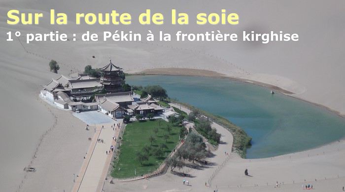
The Chinese Far West More than 30 years after my first trip to eastern China, I finally fulfilled an old dream: traveling solo from Beijing to the far west, discovering Xinjiang, the Uyghur people and the oppression they endure, the oases of Turpan and Kashgar, the Taklamakan Desert, the end of the Great Wall... The route was covered by train.
MENU PART 1: CHINA
1- Beijing (Jiankou) : the authentic Great Wall, without tourists 2- Cycling in Beijing, the best way to get around 3- Beijing : departure for the far west 4- Jiayuguan : getting by without English 5- Jiayuguan : scams and heritage 6- Dunhuang : abundance in the middle of the desert 7- Turpan : the Uyghurs under heavy surveillance 8- Kashgar : love at first sight for the old city 9- Kashgar : China’s recipe for controlling the populace 10- Tashkurgan : what on earth was I thinking going there! Kyrgyz border: a surreal epic Photo album from the 80s, contributions from other travelers (page 2)
1- JIANKOU Finding the authentic Great Wall, without tourists or a guide Friday, August 24, 2018 Thirty years later, I didn’t feel like revisiting the Great Wall at Badaling or any other overcrowded site. I chose to explore it at Jiankou, in its wildest, most authentic, and unrestored section, starting from a lost village deep in a valley—though it wasn’t *that* lost, since it had everything for communication.
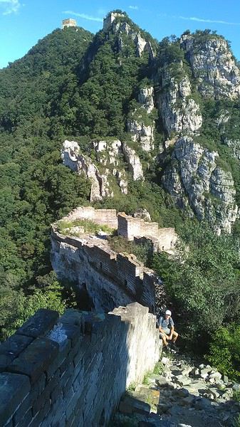
No need to pay for a taxi to get there—by timing it right, you can take the bus for just a few yuan. You have to get off at Xizhazi, the bus terminus. Be careful, there are only two buses a day in each direction. At the Xizhazi bus stop, I met a young couple who’d arrived with zero information about what to expect. We hiked the three of us toward the restored section of Mutianyu.
Still, be cautious With GPS and a topographic map (OpenTopoMap), you can set off without a problem or guide. The trail up to Jiankou is easy and well-marked. The trails down are too. But be careful—once you’re on the Wall, it’s real mountain hiking, with easy but dangerous climbing sections (over sheer drops). Not for amateurs or those afraid of heights! But what a reward. The Wall all to yourself, where it’s at its most daring. Truly mesmerizing.
More photos...
2- BEIJING The best way to get around the capital Sunday, August 26 The best way to explore the city is still by bike. Most are in a bike-share system, but you need to use an app—WeChat, the app that does everything, like monitoring your every move. No way I was installing that.
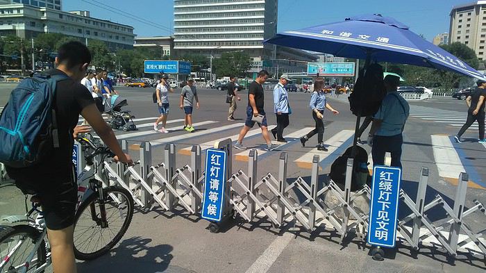
I found one at a rental shop near the hostel. The key is to quickly learn local traffic customs to minimize risks. Bike lanes are wide along the avenues.
But you still have to: - Watch out for anything parked on the bike paths—the most annoying are people napping or talking on the phone in their cars - Keep an eye on everything coming the wrong way—the list is long - The worst is right turns on red, which in Chinese traffic rules seem to have priority Once you get the hang of it, it’s fine. The city is huge but flat, so you can just wing it.
3- BEIJING By train to the far west Sunday, August 26 Beijing West Station is the size and operates like an airport. With your e-ticket from the agency, you first have to pick up your ticket at the special "English" counter, after passing through security. With your ticket in hand, you have to exit and enter through the boarding waiting area—not the platform—after a second security check.
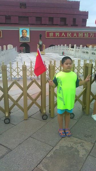 Then you find the right hall and wait for the sign to finally access the platform. In the end, it works pretty well given the incredible number of passengers to manage. Everywhere in Beijing, I saw that the Chinese have mastered crowd flow management.
Nice surprise: second-class carriages are clean, air-conditioned, and bright. Perfect, since I was in for 20 hours. One uniformed attendant per carriage, mobile meal service—luxury! Small downside: no luggage space. Hauling your suitcase up to the top bunk is quite a workout. I was in the middle, so it wasn’t too bad. The landscape, though, whether rural or urban, is pretty bleak. That should change once we leave the eastern plains.
Of course, I got my first police visit, with a thorough passport check and bag search. I was warned—going to the Chinese far west exposes you to this kind of hassle. But they were polite and respectful.
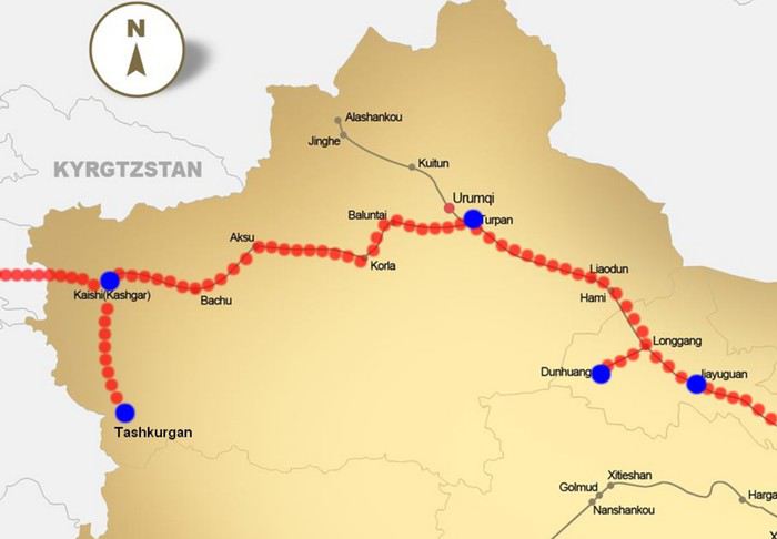 The Chinese Far West
4- JIAYUGUAN Getting by without English Monday, August 27 At the gates of two deserts (Gobi and Taklamakan) and at the foot of the Tibetan highlands, the Great Wall ends at Jiayuguan. Here, I found the deeper China I’d somewhat rediscovered during my bike ride, even if now everyone gets around on electric bikes and I’m no longer stared at like an alien.
Prices are nothing like Beijing: you can find a full meal for 2 €, and my bike cost 7 € for two days. Plus, few people speak English—neither the owner of the HI hostel where I stayed, nor the ticket sellers at the sites, let alone the servers at the small eateries where I ate. Everything is written in Chinese. So I had to use the little Chinese I know to communicate about essentials. It makes the locals laugh to see a European trying to speak their language, but it earns respect. With Google Translate’s help, I managed.
Rant: With their avenues blocked for construction for kilometers without warning, and new roads not yet on maps, I must’ve taken 15 km of detours. More photos...
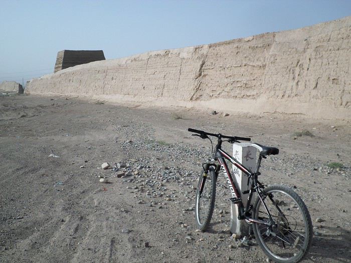
5- JIAYUGUAN Scams and heritage Tuesday, August 28 The Great Wall doesn’t exactly end at the fort I visited yesterday but 10 km further, at the entrance to a river gorge at the foot of the mountains. All that’s left is a badly damaged tower (more like a mound of earth) and a section of clay wall, similar to the one I biked yesterday.
This morning, I hopped on my bike, determined to venture into the desert to see this highly symbolic site. First, you access it via a wide, brand-new road with not a soul in sight. Just before the site, I came across a grand welcome gate, very period-style, but it’s actually the inevitable toll booth.
Behind the gate, the road continues straight to the site, which you can see in the distance—at least 2 km away—the remains of the tower and wall. I had to leave my bike here. Fine. I went to the ticket counter and asked the price: 120 yuan! I couldn’t believe it—over 15 € for a simple mound of earth.
I showed my displeasure to the attendant, who couldn’t care less, and immediately turned back. 120 yuan—that’s the price for a new road, a fancy gate planted 2 km before the site just to force you to take a shuttle, and employees with nothing to do all day... Now I understand why I didn’t meet anyone!
Heritage China is a bit pricey Generally, sites are expensive for the country’s standard of living, but travelers are supposed to have money, so why hold back? I even gave up on the Forbidden City—reservations required days in advance (or on the black market at an impossible price). I prefer to keep the memory of my first visit, when entry must’ve cost a few dozen cents, and there were only a handful of visitors.
This morning, I took a taxi to see remarkable tombs of common people from the 3rd to 6th centuries. They’re small vaulted caves made of painted bricks, depicting scenes of daily life. Very pretty and moving. But even here, though the price was more reasonable, I was left wanting—only one of the 16 tombs is open to visitors, and it’s apparently not the most beautiful.
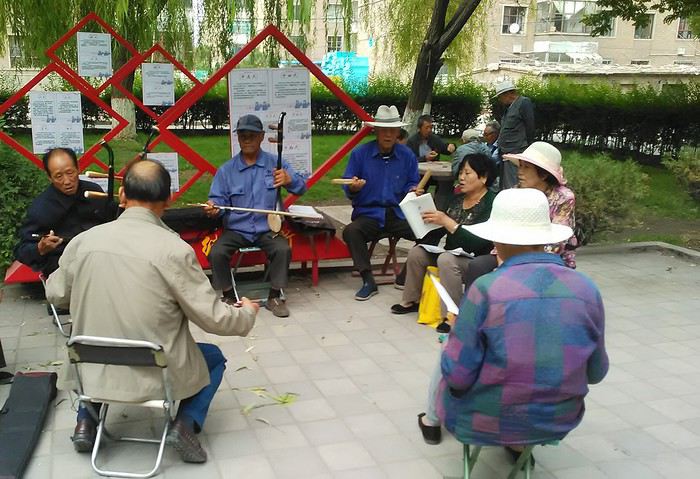
The authentic China—at least what’s left of it... Wandering the impersonal avenues of the city, you stumble upon a market. There, you still find traditional China—small shops with questionable hygiene, Go players, musicians, and even a dental prosthetist. The last refuge for those untouched by modernity. More photos...
6- DUNHUANG Abundance in the middle of the desert Wednesday, August 29 Well, I thought the landscape would be less bleak as I headed west. Nope. The only distraction in this expanse of dark, clayey sand is the forests of pylons and wind turbines, plus wild camels racing each other.
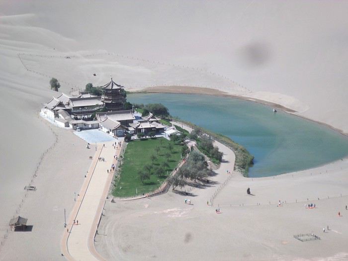 However, Dunhuang, the gateway to the Taklamakan, is by far the most pleasant Chinese city I know. There’s a real city center you can explore on foot. It’s hot but not unbearable, with a light, dry breeze. Much nicer than Beijing. The Han Chinese are still the majority, but the Muslim Uyghurs are more numerous, and the muezzin’s call to prayer echoes around the mosque.
The most surprising thing is the abundance and diversity of fruits and vegetables. You wonder how it all grows here. Well-irrigated, the desert sands are very fertile. Here, raisins have subtle, mysterious flavors, and the lamb really tastes like lamb.
Today, I visited the must-see Mingshashan, a dune complex next to which Pila is a molehill. The Basque Country, but covered in sand... More photos...
7- TURPAN The Uyghurs under heavy surveillance Friday, August 31 Surveillance cameras everywhere in the city, armed police stationed at intersections, in front of public buildings, at the entrance and inside tourist sites, police stations on every corner, patrols on foot or by car, khaki uniforms even for middle schoolers... here, the Han Chinese are in the minority, and you can feel it. Turpan feels like a city under siege.
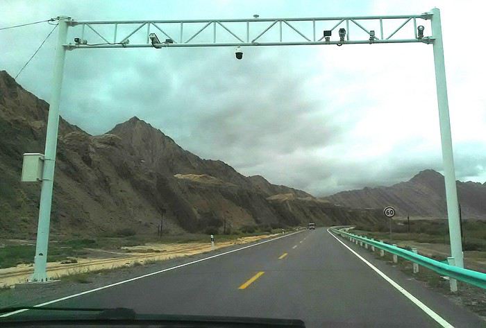
To enter the youth hostel where I stayed, there’s even a security gate, and the receptionist (a Han, like everyone in tourism) wears a bulletproof vest! Reassuring. Still, you don’t feel particularly threatened here, especially as a European. The troublemakers are the Chinese, not the Uyghurs. Generally, China is a very safe country for visitors.
Smile, you’re on camera! I was biking on an avenue when the car in front of me got flashed for driving slowly. I quickly understood why when I got flashed too.
Here, the official time is Beijing time, but it gets dark two hours later. It’ll be even worse in Kashgar. Trickier to manage: everything is displayed in Chinese and Arabic. Nothing in English. Choosing a menu is a shot in the dark. Apart from a few young Chinese, no one here speaks English, and my Chinese doesn’t seem very understandable...
Mogao, the end of the road for the Han Yesterday, near Dunhuang, I went to Mogao, a complex of decorated caves with Buddha sculptures and paintings. Stunning, but so crowded! Luckily, here in Turpan, Chinese tourists barely venture out. So I visited a Silk Road ghost town with only a handful of other visitors and under a howling wind.
The modern Chinese city is swallowing up the old Uyghur neighborhoods—only a museum-like district remains in the center, and pockets of resistance on the outskirts are doomed to disappear soon. More photos...
8- KASHGAR A (relative) love at first sight for the old city Sunday, September 2 After three overnight trains, here I am in the far west of China, nearly 4,000 km from the capital. Despite the omnipresent police and an old city preserved UNESCO-style, Kashgar is my Chinese love at first sight.
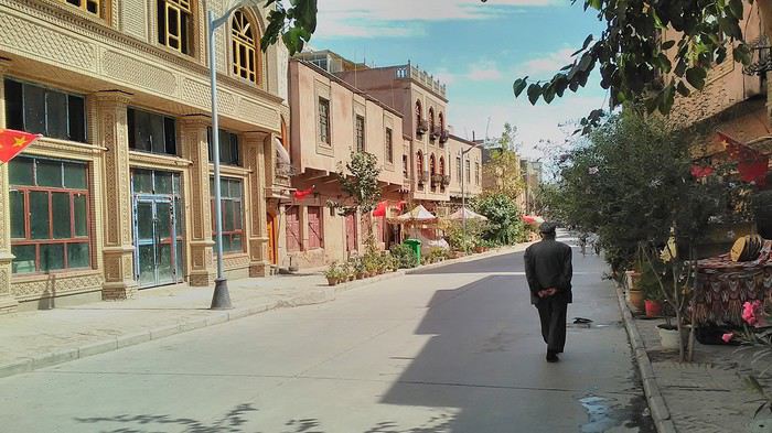
Finally, Chinese... well, sort of, because we’re in Uyghur territory here—a Turkic people with nothing culturally in common with the Han, the eastern Chinese. It started badly yesterday at Turfan station, where after three security gate passes, at least five passport checks, and a bag search, three adorable policewomen confiscated my antibacterial lotion because it had a flammable logo...
Then came the welcoming committee of armed cops at Kashgar station. Once all that was over, they left me alone—except you still have to go through security checks like everyone else to enter the old city, the bazaar, the livestock market... The further west you go, the more the siege mentality is evident. Luckily, the border isn’t far...
Despite the inevitable destruction-reconstruction, the city center has been well preserved. Thankfully, because it’s a very original style, a mix of local and colonial. I love it, even if it’s a bit too artificial, sanitized, and watered-down, and rather empty of residents. On the Silk Road, the city was famous for its great food. And it still is—rarely have I seen such richness and abundance of food! And not just scorpions or snakes. More photos...
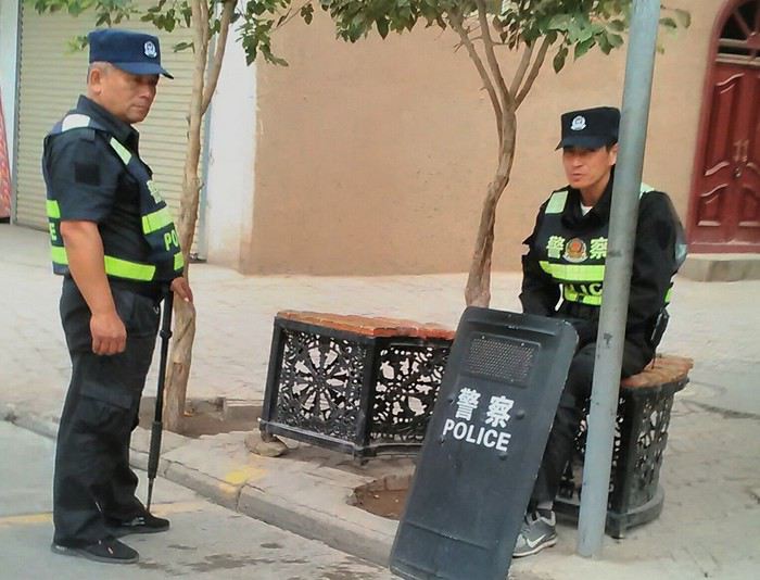
9- KASHGAR China’s recipe for controlling the populace Saturday, September 1 Xinjiang, along with Tibet, is a "sensitive" area of rebellion in the eyes of Chinese authorities. As a result, the state has these regions and their populations under total control. Tourists also feel the consequences, even if they’re not at risk of re-education camps.
 - Putting barbed wire and anti-ramming barriers around sensitive sites (schools, big hotels, government buildings...)
- Installing traffic surveillance gates with cameras and photo flashes (for all vehicles passing, including bikes) throughout the city and even in the countryside
- Posting uniformed guards with tasers, batons, or huge baseball bats every 100 meters
- Training the Han population (ethnic Chinese) in self-defense with sticks, preferably in the morning on the street. Men and women of all ages
- Starting school with the national anthem, doing military exercises, and receiving political indoctrination, all neatly lined up in the courtyard. (The dream school for any teacher)
- Placing a snitch in uniform (a pseudo-guard) in public gathering places, like youth hostels. Mine spends the day loafing around the courtyard
- Putting Chinese flags everywhere on the streets to remind everyone who’s in charge
- Installing security gates at every entrance to areas frequented by tourists (thanks for that) but not just there
- Never photographing cops, or else! I tried, but it’s not easy...
- Putting barbed wire and anti-ramming barriers around sensitive sites (schools, big hotels, government buildings...)
- Installing traffic surveillance gates with cameras and photo flashes (for all vehicles passing, including bikes) throughout the city and even in the countryside
- Posting uniformed guards with tasers, batons, or huge baseball bats every 100 meters
- Training the Han population (ethnic Chinese) in self-defense with sticks, preferably in the morning on the street. Men and women of all ages
- Starting school with the national anthem, doing military exercises, and receiving political indoctrination, all neatly lined up in the courtyard. (The dream school for any teacher)
- Placing a snitch in uniform (a pseudo-guard) in public gathering places, like youth hostels. Mine spends the day loafing around the courtyard
- Putting Chinese flags everywhere on the streets to remind everyone who’s in charge
- Installing security gates at every entrance to areas frequented by tourists (thanks for that) but not just there
- Never photographing cops, or else! I tried, but it’s not easy...
With all that, you can stroll around safely Not much crime! As for the amount the Chinese state spends to maintain such a system, it’s staggering! A third of the Han living in Xinjiang work in security. Today, I wandered freely around old Kashgar, which is quite large after all. More photos...
10- TASHKURGAN What on earth was I thinking going there! Wednesday, September 5 First, there’s the taxi—pretty crappy, with a driver who doesn’t speak a word of English and won’t stop smoking. Over six hours in that... shared with a completely out-of-it American.
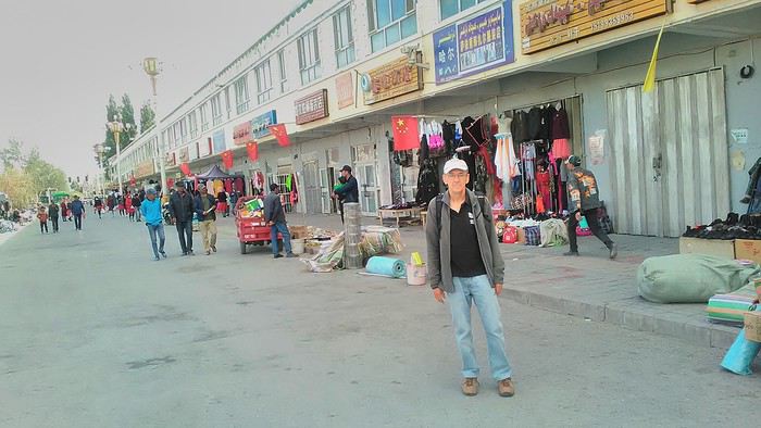
Then there are all the checkpoints along the way. I won’t go on—you know the drill by now.
After that, there’s Tashkurgan—a town with nothing to see, nothing to do. Deserted as soon as night falls. There’s this huge youth hostel and a few lost Chinese tapping away on their smartphones, chain-smoking. This lost American-European crowd, swapping tips on how to enter Pakistan or Tajikistan.
Luckily, there’s the Chinese Pamir Highway, lined with peaks over 7,000m. There’s the feeling of no longer being in China, with a population whose features are Middle Eastern. And these Tajik women with their stunning hairstyles and vibrant costumes. There’s the fact of having reached the westernmost Chinese city, far from crowds and tourist sites. A sort of end of the world. More photos...
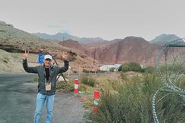
11- KYRGYZ BORDER A surreal epic Thursday, September 6 The road from Kashgar to the Kyrgyzstan border is a little over 200 km and passes through beautiful landscapes of colorful, desert-like mountains with acrobatic folds. That’s the bucolic part of the trip.
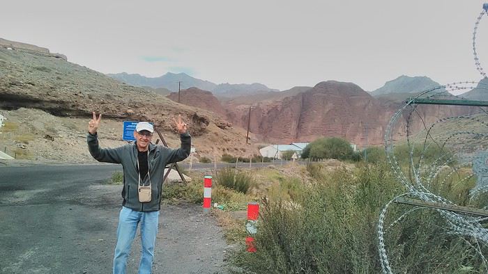 Yesterday, I managed to gather four people to rent a minibus to reach the border more easily: a Spaniard and an Argentine I’d already met in Turpan, and two New Zealanders who responded to the ad left at the hostel.
Absurdity and paranoia of Chinese authorities The highlight was crossing the town of Wuqia, 50 km past Kashgar. After tallying up with my fellow sufferers, we must’ve passed about ten checkpoints with: - Passport checks: 14 times, sometimes by two cops side by side - Bag checks: 4 times - Smartphone checks: 2 times, with deletion of "non-compliant" photos, and registration of your IMEI in the exit log!... Absurd and surreal at the same time, since my camera stayed in my bag, my apps are in French, and my photos have been online for ages...
With all that, we arrived just as the last checkpoint before the no man’s land marking the border between the two countries was on lunch break. And bam! Another 1.5-hour wait, alongside truckers who were much more used to this than we were.
What to think? The cops themselves aren’t fooled. They play the role they’re asked to, but sometimes you can coax a smile out of them—they realize how ridiculous the situation is.
What’s the point? That’s the big question my companions and I were tempted to answer with "to piss people off." To show you your place isn’t here, but with the other tourists, over there in the east, in Shanghai, Xi’an, or Guangzhou.
As for you, a traveler from a democratic country, you really experience this as aggression, humiliation, a violation of your private space. And yet, I’m respected, they speak to me properly. Today, I better understand what a Palestinian or a citizen of an occupied country might feel daily. A unique experience! Thanks, China.
And to top it off, the cherry on the cake! It’s still this glowing button you press to rate your passage after clearing the last obstacle before the exit stamp. I was so surprised it turned off before I could react. The Spaniard, with great humor and irony, had time to vote "excellent." In the end, he wasn’t wrong—you can hardly do better!
PS: I ditched my buddies at the border. They didn’t want to pay for a taxi to continue. So I took a direct taxi to Osh. The first 100 km are fabulous. I couldn’t take many photos, but I’ll be back on Monday to go to Tajikistan.
More photos...
The rest of the Silk Road, Part 2, in these travel journals: Kyrgyzstan, Tajikistan, Uzbekistan.
The Chinese Far West More than 30 years after my first trip to eastern China, I finally fulfilled an old dream: traveling solo from Beijing to the far west, discovering Xinjiang, the Uyghur people and the oppression they endure, the oases of Turpan and Kashgar, the Taklamakan Desert, the end of the Great Wall... The route was covered by train.
MENU PART 1: CHINA
1- Beijing (Jiankou) : the authentic Great Wall, without tourists 2- Cycling in Beijing, the best way to get around 3- Beijing : departure for the far west 4- Jiayuguan : getting by without English 5- Jiayuguan : scams and heritage 6- Dunhuang : abundance in the middle of the desert 7- Turpan : the Uyghurs under heavy surveillance 8- Kashgar : love at first sight for the old city 9- Kashgar : China’s recipe for controlling the populace 10- Tashkurgan : what on earth was I thinking going there! Kyrgyz border: a surreal epic Photo album from the 80s, contributions from other travelers (page 2)
1- JIANKOU Finding the authentic Great Wall, without tourists or a guide Friday, August 24, 2018 Thirty years later, I didn’t feel like revisiting the Great Wall at Badaling or any other overcrowded site. I chose to explore it at Jiankou, in its wildest, most authentic, and unrestored section, starting from a lost village deep in a valley—though it wasn’t *that* lost, since it had everything for communication.
No need to pay for a taxi to get there—by timing it right, you can take the bus for just a few yuan. You have to get off at Xizhazi, the bus terminus. Be careful, there are only two buses a day in each direction. At the Xizhazi bus stop, I met a young couple who’d arrived with zero information about what to expect. We hiked the three of us toward the restored section of Mutianyu.
Still, be cautious With GPS and a topographic map (OpenTopoMap), you can set off without a problem or guide. The trail up to Jiankou is easy and well-marked. The trails down are too. But be careful—once you’re on the Wall, it’s real mountain hiking, with easy but dangerous climbing sections (over sheer drops). Not for amateurs or those afraid of heights! But what a reward. The Wall all to yourself, where it’s at its most daring. Truly mesmerizing.
More photos...
2- BEIJING The best way to get around the capital Sunday, August 26 The best way to explore the city is still by bike. Most are in a bike-share system, but you need to use an app—WeChat, the app that does everything, like monitoring your every move. No way I was installing that.
I found one at a rental shop near the hostel. The key is to quickly learn local traffic customs to minimize risks. Bike lanes are wide along the avenues.
But you still have to: - Watch out for anything parked on the bike paths—the most annoying are people napping or talking on the phone in their cars - Keep an eye on everything coming the wrong way—the list is long - The worst is right turns on red, which in Chinese traffic rules seem to have priority Once you get the hang of it, it’s fine. The city is huge but flat, so you can just wing it.
3- BEIJING By train to the far west Sunday, August 26 Beijing West Station is the size and operates like an airport. With your e-ticket from the agency, you first have to pick up your ticket at the special "English" counter, after passing through security. With your ticket in hand, you have to exit and enter through the boarding waiting area—not the platform—after a second security check.
Then you find the right hall and wait for the sign to finally access the platform. In the end, it works pretty well given the incredible number of passengers to manage. Everywhere in Beijing, I saw that the Chinese have mastered crowd flow management.Nice surprise: second-class carriages are clean, air-conditioned, and bright. Perfect, since I was in for 20 hours. One uniformed attendant per carriage, mobile meal service—luxury! Small downside: no luggage space. Hauling your suitcase up to the top bunk is quite a workout. I was in the middle, so it wasn’t too bad. The landscape, though, whether rural or urban, is pretty bleak. That should change once we leave the eastern plains.
Of course, I got my first police visit, with a thorough passport check and bag search. I was warned—going to the Chinese far west exposes you to this kind of hassle. But they were polite and respectful.
The Chinese Far West4- JIAYUGUAN Getting by without English Monday, August 27 At the gates of two deserts (Gobi and Taklamakan) and at the foot of the Tibetan highlands, the Great Wall ends at Jiayuguan. Here, I found the deeper China I’d somewhat rediscovered during my bike ride, even if now everyone gets around on electric bikes and I’m no longer stared at like an alien.
Prices are nothing like Beijing: you can find a full meal for 2 €, and my bike cost 7 € for two days. Plus, few people speak English—neither the owner of the HI hostel where I stayed, nor the ticket sellers at the sites, let alone the servers at the small eateries where I ate. Everything is written in Chinese. So I had to use the little Chinese I know to communicate about essentials. It makes the locals laugh to see a European trying to speak their language, but it earns respect. With Google Translate’s help, I managed.
Rant: With their avenues blocked for construction for kilometers without warning, and new roads not yet on maps, I must’ve taken 15 km of detours. More photos...
5- JIAYUGUAN Scams and heritage Tuesday, August 28 The Great Wall doesn’t exactly end at the fort I visited yesterday but 10 km further, at the entrance to a river gorge at the foot of the mountains. All that’s left is a badly damaged tower (more like a mound of earth) and a section of clay wall, similar to the one I biked yesterday.
This morning, I hopped on my bike, determined to venture into the desert to see this highly symbolic site. First, you access it via a wide, brand-new road with not a soul in sight. Just before the site, I came across a grand welcome gate, very period-style, but it’s actually the inevitable toll booth.
Behind the gate, the road continues straight to the site, which you can see in the distance—at least 2 km away—the remains of the tower and wall. I had to leave my bike here. Fine. I went to the ticket counter and asked the price: 120 yuan! I couldn’t believe it—over 15 € for a simple mound of earth.
I showed my displeasure to the attendant, who couldn’t care less, and immediately turned back. 120 yuan—that’s the price for a new road, a fancy gate planted 2 km before the site just to force you to take a shuttle, and employees with nothing to do all day... Now I understand why I didn’t meet anyone!
Heritage China is a bit pricey Generally, sites are expensive for the country’s standard of living, but travelers are supposed to have money, so why hold back? I even gave up on the Forbidden City—reservations required days in advance (or on the black market at an impossible price). I prefer to keep the memory of my first visit, when entry must’ve cost a few dozen cents, and there were only a handful of visitors.
This morning, I took a taxi to see remarkable tombs of common people from the 3rd to 6th centuries. They’re small vaulted caves made of painted bricks, depicting scenes of daily life. Very pretty and moving. But even here, though the price was more reasonable, I was left wanting—only one of the 16 tombs is open to visitors, and it’s apparently not the most beautiful.
The authentic China—at least what’s left of it... Wandering the impersonal avenues of the city, you stumble upon a market. There, you still find traditional China—small shops with questionable hygiene, Go players, musicians, and even a dental prosthetist. The last refuge for those untouched by modernity. More photos...
6- DUNHUANG Abundance in the middle of the desert Wednesday, August 29 Well, I thought the landscape would be less bleak as I headed west. Nope. The only distraction in this expanse of dark, clayey sand is the forests of pylons and wind turbines, plus wild camels racing each other.
However, Dunhuang, the gateway to the Taklamakan, is by far the most pleasant Chinese city I know. There’s a real city center you can explore on foot. It’s hot but not unbearable, with a light, dry breeze. Much nicer than Beijing. The Han Chinese are still the majority, but the Muslim Uyghurs are more numerous, and the muezzin’s call to prayer echoes around the mosque.The most surprising thing is the abundance and diversity of fruits and vegetables. You wonder how it all grows here. Well-irrigated, the desert sands are very fertile. Here, raisins have subtle, mysterious flavors, and the lamb really tastes like lamb.
Today, I visited the must-see Mingshashan, a dune complex next to which Pila is a molehill. The Basque Country, but covered in sand... More photos...
7- TURPAN The Uyghurs under heavy surveillance Friday, August 31 Surveillance cameras everywhere in the city, armed police stationed at intersections, in front of public buildings, at the entrance and inside tourist sites, police stations on every corner, patrols on foot or by car, khaki uniforms even for middle schoolers... here, the Han Chinese are in the minority, and you can feel it. Turpan feels like a city under siege.
To enter the youth hostel where I stayed, there’s even a security gate, and the receptionist (a Han, like everyone in tourism) wears a bulletproof vest! Reassuring. Still, you don’t feel particularly threatened here, especially as a European. The troublemakers are the Chinese, not the Uyghurs. Generally, China is a very safe country for visitors.
Smile, you’re on camera! I was biking on an avenue when the car in front of me got flashed for driving slowly. I quickly understood why when I got flashed too.
Here, the official time is Beijing time, but it gets dark two hours later. It’ll be even worse in Kashgar. Trickier to manage: everything is displayed in Chinese and Arabic. Nothing in English. Choosing a menu is a shot in the dark. Apart from a few young Chinese, no one here speaks English, and my Chinese doesn’t seem very understandable...
Mogao, the end of the road for the Han Yesterday, near Dunhuang, I went to Mogao, a complex of decorated caves with Buddha sculptures and paintings. Stunning, but so crowded! Luckily, here in Turpan, Chinese tourists barely venture out. So I visited a Silk Road ghost town with only a handful of other visitors and under a howling wind.
The modern Chinese city is swallowing up the old Uyghur neighborhoods—only a museum-like district remains in the center, and pockets of resistance on the outskirts are doomed to disappear soon. More photos...
8- KASHGAR A (relative) love at first sight for the old city Sunday, September 2 After three overnight trains, here I am in the far west of China, nearly 4,000 km from the capital. Despite the omnipresent police and an old city preserved UNESCO-style, Kashgar is my Chinese love at first sight.
Finally, Chinese... well, sort of, because we’re in Uyghur territory here—a Turkic people with nothing culturally in common with the Han, the eastern Chinese. It started badly yesterday at Turfan station, where after three security gate passes, at least five passport checks, and a bag search, three adorable policewomen confiscated my antibacterial lotion because it had a flammable logo...
Then came the welcoming committee of armed cops at Kashgar station. Once all that was over, they left me alone—except you still have to go through security checks like everyone else to enter the old city, the bazaar, the livestock market... The further west you go, the more the siege mentality is evident. Luckily, the border isn’t far...
Despite the inevitable destruction-reconstruction, the city center has been well preserved. Thankfully, because it’s a very original style, a mix of local and colonial. I love it, even if it’s a bit too artificial, sanitized, and watered-down, and rather empty of residents. On the Silk Road, the city was famous for its great food. And it still is—rarely have I seen such richness and abundance of food! And not just scorpions or snakes. More photos...
9- KASHGAR China’s recipe for controlling the populace Saturday, September 1 Xinjiang, along with Tibet, is a "sensitive" area of rebellion in the eyes of Chinese authorities. As a result, the state has these regions and their populations under total control. Tourists also feel the consequences, even if they’re not at risk of re-education camps.
- Putting barbed wire and anti-ramming barriers around sensitive sites (schools, big hotels, government buildings...)
- Installing traffic surveillance gates with cameras and photo flashes (for all vehicles passing, including bikes) throughout the city and even in the countryside
- Posting uniformed guards with tasers, batons, or huge baseball bats every 100 meters
- Training the Han population (ethnic Chinese) in self-defense with sticks, preferably in the morning on the street. Men and women of all ages
- Starting school with the national anthem, doing military exercises, and receiving political indoctrination, all neatly lined up in the courtyard. (The dream school for any teacher)
- Placing a snitch in uniform (a pseudo-guard) in public gathering places, like youth hostels. Mine spends the day loafing around the courtyard
- Putting Chinese flags everywhere on the streets to remind everyone who’s in charge
- Installing security gates at every entrance to areas frequented by tourists (thanks for that) but not just there
- Never photographing cops, or else! I tried, but it’s not easy...With all that, you can stroll around safely Not much crime! As for the amount the Chinese state spends to maintain such a system, it’s staggering! A third of the Han living in Xinjiang work in security. Today, I wandered freely around old Kashgar, which is quite large after all. More photos...
10- TASHKURGAN What on earth was I thinking going there! Wednesday, September 5 First, there’s the taxi—pretty crappy, with a driver who doesn’t speak a word of English and won’t stop smoking. Over six hours in that... shared with a completely out-of-it American.
Then there are all the checkpoints along the way. I won’t go on—you know the drill by now.
After that, there’s Tashkurgan—a town with nothing to see, nothing to do. Deserted as soon as night falls. There’s this huge youth hostel and a few lost Chinese tapping away on their smartphones, chain-smoking. This lost American-European crowd, swapping tips on how to enter Pakistan or Tajikistan.
Luckily, there’s the Chinese Pamir Highway, lined with peaks over 7,000m. There’s the feeling of no longer being in China, with a population whose features are Middle Eastern. And these Tajik women with their stunning hairstyles and vibrant costumes. There’s the fact of having reached the westernmost Chinese city, far from crowds and tourist sites. A sort of end of the world. More photos...
11- KYRGYZ BORDER A surreal epic Thursday, September 6 The road from Kashgar to the Kyrgyzstan border is a little over 200 km and passes through beautiful landscapes of colorful, desert-like mountains with acrobatic folds. That’s the bucolic part of the trip.
Yesterday, I managed to gather four people to rent a minibus to reach the border more easily: a Spaniard and an Argentine I’d already met in Turpan, and two New Zealanders who responded to the ad left at the hostel.Absurdity and paranoia of Chinese authorities The highlight was crossing the town of Wuqia, 50 km past Kashgar. After tallying up with my fellow sufferers, we must’ve passed about ten checkpoints with: - Passport checks: 14 times, sometimes by two cops side by side - Bag checks: 4 times - Smartphone checks: 2 times, with deletion of "non-compliant" photos, and registration of your IMEI in the exit log!... Absurd and surreal at the same time, since my camera stayed in my bag, my apps are in French, and my photos have been online for ages...
With all that, we arrived just as the last checkpoint before the no man’s land marking the border between the two countries was on lunch break. And bam! Another 1.5-hour wait, alongside truckers who were much more used to this than we were.
What to think? The cops themselves aren’t fooled. They play the role they’re asked to, but sometimes you can coax a smile out of them—they realize how ridiculous the situation is.
What’s the point? That’s the big question my companions and I were tempted to answer with "to piss people off." To show you your place isn’t here, but with the other tourists, over there in the east, in Shanghai, Xi’an, or Guangzhou.
As for you, a traveler from a democratic country, you really experience this as aggression, humiliation, a violation of your private space. And yet, I’m respected, they speak to me properly. Today, I better understand what a Palestinian or a citizen of an occupied country might feel daily. A unique experience! Thanks, China.
And to top it off, the cherry on the cake! It’s still this glowing button you press to rate your passage after clearing the last obstacle before the exit stamp. I was so surprised it turned off before I could react. The Spaniard, with great humor and irony, had time to vote "excellent." In the end, he wasn’t wrong—you can hardly do better!
PS: I ditched my buddies at the border. They didn’t want to pay for a taxi to continue. So I took a direct taxi to Osh. The first 100 km are fabulous. I couldn’t take many photos, but I’ll be back on Monday to go to Tajikistan.
More photos...
The rest of the Silk Road, Part 2, in these travel journals: Kyrgyzstan, Tajikistan, Uzbekistan.
Brelan d'as dans les Stans: Kirghizistan, Tadjikistan et Ouzbekistan
Hello tous,
C'est avec plaisir que je vous fait partager notre voyage de l'été 2019 dans les pays en stan.🙂
La version complète est ici, elle se construit au même rythme que je fais paraitre mes posts
GENESE Mais quelle idée d’aller dans les stan ! En fait, à l’origine cela devait être le Ladakh (joliment raconté par Diamina et Ticapi que je salue). Mais la crainte de ne pas arriver à tenir sur des treks de longues durées et le fait de ne pas pouvoir conduire moi-même m’ont incité à chercher une alternative. C’est là que Marie(Mlefevre) a eu le bon goût de publier un carnet sur le Kirghizistan et Perju de relater son voyage dans les stans, les deux en self drive …. C’est bon on tient notre destination 2019 ! Au niveau pays, ambiance, c’est d‘abord le corridor de Wakham et le Pamir qui m’ont séduit et ce sera le « centre » du voyage. En revanche je n’ai pas trouvé grand-chose au niveau véhicule de location au Tadjikistan. Comme ce voyage se faisait avec des amis de longues dates (avec qui on a déjà sillonné la Bolivie et le nord-ouest de la Namibie) j’ai trouvé intéressant d’y adjoindre un petit bout de Kirghizistan qui leur permettait de voir un autre type de paysage et en plus il est beaucoup plus facile de louer un véhicule à Bishkek. Lorsque ma chère et tendre a vu que nous n’étions pas loin de Samarcande (qu’on avait admiré en 2007) elle a souhaité y retourner. Du coup cela nous a fait un voyage avec 3 ambiances différentes, ce qui est génial pour nous. Niveau durée il a fallu rajouter un petit bout aux 3 semaines initialement prévues pour arriver à tout faire tenir.

PREPARATION
A partir de là j’ai commencé à construire notre parcours. En parallèle j’ai fait des recherches (et demandes) pour le véhicule. Au final, j’ai retenu une agence Ouzbek francophone qui a tout de suite compris nos problématiques d’Européens (véhicule récent, avec matériel de camping, avec les différents transferts et qui prend en charge les quelques réservations d’hôtels, guides, etc, ..). Le véhicule sera donc un Toyota Prado de 2012. La compagnie aérienne sera Turkish Airline qui dessert très bien les pays en Stan (même un vol Samarcande - Istanbul) Visas: pour le Kirghizistan il est délivré directement à l'aéroport, en revanche pour le Tadjikistan il faut le demander à l'avance. ATTENTION, le Pamir nécessite un permis particulier (comme c'est une région semi-autonome), il faut le demander en même temps que le visa en cochant la case permit GBAO (région autonome duHaut-Badakhchan).
OUTILS Comme c'est une destination encore peu couru en self drive je vais développer un peu plus que d'hab. Au niveau guide papier: Je n'ai pas mis de "S" car il n’y en a eu quasiment qu’un, mais qui pour le coup est parfait pour qui veut voyager comme nous : le nouveau guide de Cecile Miramont et Laurent Bendel : KIRGHIZISTAN TADJIKISTAN, qui a été écrit à destination des self-drivers et qui propose différents itinéraires commentés. Mon conseil, après le voyage : le guide n’enjolive pas les choses et s’adresse plutôt aux personnes ayant déjà des notions de « off road » ou de voyage « solitaire », donc quand ils écrivent "difficile" ça l’est vraiment, même "moyen" c’est déjà costaud. Par forcément au niveau difficulté de la piste elle-même mais par la dangerosité liée à la solitude, le peu de traces et le risque de croiser des gués plus ou moins remplis. Au niveau carte: il y en a une très belle et complète pour le Pamir, il s'agit de celle de Markus Hauser édité par Gekco Maps.
Comme je suis très GPS j'ai fait pas mal de recherches. Pour Garmin je n'ai pas été plus séduit que ça. Du coup je me suis penché sur les applications Android. Je connaissais déjà MAPS.ME qui est très bien mais sans courbe de niveaux, j'ai donc aussi testé GAIA, OSMAND, TERRA MAP et SOVIET MILITARY MAPS. Cette dernière est celle qui offre le plus de possibilités de cartographie plus ou moins détaillée, dont les fameuses cartes militaires Russes ultra détaillées. Mais au final c'est OSMAND que j'ai utilisé le plus pendant le voyage, je pense même que cette application remplacera GARMIN dans mon véhicule. MAPS.ME est très bien, mais au niveau topographie elle est un cran en dessous et je l'ai trouvé moins pratique pour gérer les itinéraires. Ce qui est dommage, c'est que toutes ces applications n'ont pas leur pendant sur PC, ce qui aurait été pratique pour préparer le voyage. Du coup je fais tout sur Mapsource et je transfers ensuite les waypoints sur les applications. J'ai aussi utilisé une application où les voyageurs indiquent les lieux de bivouac (ou autre) qui leur ont plu. Il s'agit de IOVERLANDER, très bonne application également. Dernier outil et non des moindres: les CBT, ce sont les offices de tourisme version Kirghize, il y en a dans les principales villes touristiques. Ils sont du grande aide et ont bien souvent un site internet, par exemple sur celui de Nryn on peut acheter, à l'avance, les permis pour la zone frontalière. Ils peuvent aussi vous indiquer des randonnées, en organiser avec des guides, gérer les hébergements, ... Pour le Pamir vous avez l'équivalent qui se nomme PECTA, nous y achèterons les permis pour circuler dans le parc de Zorgul. Il y a aussi le site visitpamirs.com qui regroupe un certain nombre d'informations.
RAVITAILLEMENT et EQUIPEMENT : au Kirghizistan aucun problème, en revanche au Tadjikistan c’est une autre histoire, sur les hauts plateaux très peu de choses disponibles, mais comme on s’y attendait on avait amené des « sachets de graines ». Au niveau vestimentaire il faut de quoi résister au froid (polaire, doudoune, bonnet) mais sans que ce soit extrême non plus (je crois que nous n'avons jamais eu des températures négatives). EN revanche pour la nuit vaut mieux avoir de bon duvets, il a fait entre 0° et 15° suivant l'altitude et la localisation.
Compagnie Turkish Airline qui dessert très bien les pays en Stan (même un vol Samarcande - Istanbul)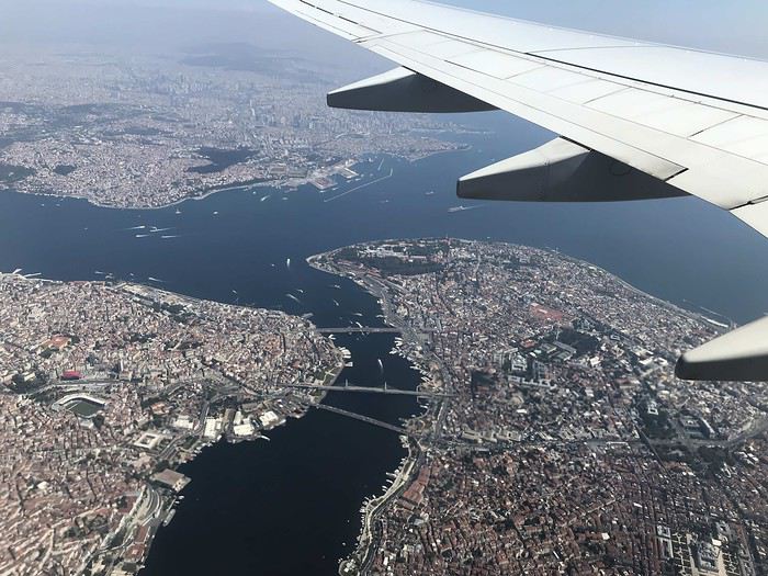
GENESE Mais quelle idée d’aller dans les stan ! En fait, à l’origine cela devait être le Ladakh (joliment raconté par Diamina et Ticapi que je salue). Mais la crainte de ne pas arriver à tenir sur des treks de longues durées et le fait de ne pas pouvoir conduire moi-même m’ont incité à chercher une alternative. C’est là que Marie(Mlefevre) a eu le bon goût de publier un carnet sur le Kirghizistan et Perju de relater son voyage dans les stans, les deux en self drive …. C’est bon on tient notre destination 2019 ! Au niveau pays, ambiance, c’est d‘abord le corridor de Wakham et le Pamir qui m’ont séduit et ce sera le « centre » du voyage. En revanche je n’ai pas trouvé grand-chose au niveau véhicule de location au Tadjikistan. Comme ce voyage se faisait avec des amis de longues dates (avec qui on a déjà sillonné la Bolivie et le nord-ouest de la Namibie) j’ai trouvé intéressant d’y adjoindre un petit bout de Kirghizistan qui leur permettait de voir un autre type de paysage et en plus il est beaucoup plus facile de louer un véhicule à Bishkek. Lorsque ma chère et tendre a vu que nous n’étions pas loin de Samarcande (qu’on avait admiré en 2007) elle a souhaité y retourner. Du coup cela nous a fait un voyage avec 3 ambiances différentes, ce qui est génial pour nous. Niveau durée il a fallu rajouter un petit bout aux 3 semaines initialement prévues pour arriver à tout faire tenir.
PREPARATION
A partir de là j’ai commencé à construire notre parcours. En parallèle j’ai fait des recherches (et demandes) pour le véhicule. Au final, j’ai retenu une agence Ouzbek francophone qui a tout de suite compris nos problématiques d’Européens (véhicule récent, avec matériel de camping, avec les différents transferts et qui prend en charge les quelques réservations d’hôtels, guides, etc, ..). Le véhicule sera donc un Toyota Prado de 2012. La compagnie aérienne sera Turkish Airline qui dessert très bien les pays en Stan (même un vol Samarcande - Istanbul) Visas: pour le Kirghizistan il est délivré directement à l'aéroport, en revanche pour le Tadjikistan il faut le demander à l'avance. ATTENTION, le Pamir nécessite un permis particulier (comme c'est une région semi-autonome), il faut le demander en même temps que le visa en cochant la case permit GBAO (région autonome duHaut-Badakhchan).
OUTILS Comme c'est une destination encore peu couru en self drive je vais développer un peu plus que d'hab. Au niveau guide papier: Je n'ai pas mis de "S" car il n’y en a eu quasiment qu’un, mais qui pour le coup est parfait pour qui veut voyager comme nous : le nouveau guide de Cecile Miramont et Laurent Bendel : KIRGHIZISTAN TADJIKISTAN, qui a été écrit à destination des self-drivers et qui propose différents itinéraires commentés. Mon conseil, après le voyage : le guide n’enjolive pas les choses et s’adresse plutôt aux personnes ayant déjà des notions de « off road » ou de voyage « solitaire », donc quand ils écrivent "difficile" ça l’est vraiment, même "moyen" c’est déjà costaud. Par forcément au niveau difficulté de la piste elle-même mais par la dangerosité liée à la solitude, le peu de traces et le risque de croiser des gués plus ou moins remplis. Au niveau carte: il y en a une très belle et complète pour le Pamir, il s'agit de celle de Markus Hauser édité par Gekco Maps.
Comme je suis très GPS j'ai fait pas mal de recherches. Pour Garmin je n'ai pas été plus séduit que ça. Du coup je me suis penché sur les applications Android. Je connaissais déjà MAPS.ME qui est très bien mais sans courbe de niveaux, j'ai donc aussi testé GAIA, OSMAND, TERRA MAP et SOVIET MILITARY MAPS. Cette dernière est celle qui offre le plus de possibilités de cartographie plus ou moins détaillée, dont les fameuses cartes militaires Russes ultra détaillées. Mais au final c'est OSMAND que j'ai utilisé le plus pendant le voyage, je pense même que cette application remplacera GARMIN dans mon véhicule. MAPS.ME est très bien, mais au niveau topographie elle est un cran en dessous et je l'ai trouvé moins pratique pour gérer les itinéraires. Ce qui est dommage, c'est que toutes ces applications n'ont pas leur pendant sur PC, ce qui aurait été pratique pour préparer le voyage. Du coup je fais tout sur Mapsource et je transfers ensuite les waypoints sur les applications. J'ai aussi utilisé une application où les voyageurs indiquent les lieux de bivouac (ou autre) qui leur ont plu. Il s'agit de IOVERLANDER, très bonne application également. Dernier outil et non des moindres: les CBT, ce sont les offices de tourisme version Kirghize, il y en a dans les principales villes touristiques. Ils sont du grande aide et ont bien souvent un site internet, par exemple sur celui de Nryn on peut acheter, à l'avance, les permis pour la zone frontalière. Ils peuvent aussi vous indiquer des randonnées, en organiser avec des guides, gérer les hébergements, ... Pour le Pamir vous avez l'équivalent qui se nomme PECTA, nous y achèterons les permis pour circuler dans le parc de Zorgul. Il y a aussi le site visitpamirs.com qui regroupe un certain nombre d'informations.
RAVITAILLEMENT et EQUIPEMENT : au Kirghizistan aucun problème, en revanche au Tadjikistan c’est une autre histoire, sur les hauts plateaux très peu de choses disponibles, mais comme on s’y attendait on avait amené des « sachets de graines ». Au niveau vestimentaire il faut de quoi résister au froid (polaire, doudoune, bonnet) mais sans que ce soit extrême non plus (je crois que nous n'avons jamais eu des températures négatives). EN revanche pour la nuit vaut mieux avoir de bon duvets, il a fait entre 0° et 15° suivant l'altitude et la localisation.
Compagnie Turkish Airline qui dessert très bien les pays en Stan (même un vol Samarcande - Istanbul)
Auto-stop en Asie Centrale: itinéraire, frontières et sécurité
Bonjour à toutes et à tous,
Je me permets de créer une nouvelle discussion car je suis à la recherche d'informations que je n'ai pas trouvé ailleurs.
Je résume brièvement mon projet afin que vous compreniez la raison de mon post. Je partirai début mai 2019 depuis la France pour rejoindre l'Asie du Sud Est en autostop, néanmoins mes questions ici concernent seulement les pays d'Asie Centrale. Voici mon itinéraire (prévisionnel) : France, pays des Balkans, Turquie, Géorgie, Arménie, Azerbaïdjan, Iran, Turkménistan, Ouzbékistan, Kirghizistan, Tadjikistan, Afghanistan, Pakistan, Inde, puis vers l'est.
Avant toute chose, je tiens à préciser que c'est un projet - à petit budget - en construction et que je suis donc ouvert à toutes vos remarques et commentaires, susceptibles de faire évoluer l'itinéraire prévu (par exemple passer par la Chine pour rejoindre l'Asie du Sud Est plutôt que Afghanistan-Pakistan-Inde, néanmoins ce sont les pays qui me motivent le plus pour ce voyage...)
Voici mes questions:
Concernant le Turkménistan, Ouzbékistan, Kirghizistan, Tadjikistan : d'après ce que j'ai lu sur internet, la pratique dans l'autostop dans ces pays ne pose pas de problème, confirmez-vous cela?
En Afghanistan : - Arriver par l'Afghanistan en autostop depuis le Tadjikistan en passant par la route Douchanbé-Kondoz est-il envisageable?
- pour des questions de sécurité la pratique de l'autostop me semble être à proscrire, néanmoins est-elle possible? Est-il possible de se déplacer en bus locaux? (habillé en local...)
- J'aimerai aller dans les villes/ régions suivantes : Mazâr-e-Charif, lac de Band-e-Amir, Whakan, en gros le nord, l'est et le nord-est du pays (puisque c'est celles qui semblent le plus accessibles), qu'en pensez-vous? Recommandez-vous d'autres endroits à visiter?
- d'après ce que j'ai lu, il faut surtout éviter les zones contrôlées par les Talibans, c'est à dire le sud du pays. Ainsi vous semble t-il envisageable de rejoindre le Pakistan en passant par la route Kondoz-Kabul-Jalalabad-Peshawar ?
- Pakistan : plus ou moins les mêmes questions que pour l'Afghanistan, c'est à dire : zones à éviter? zones "recommandées" ? routes dangereuses ? autostop possible ?
- Pakistan-Inde: quel(s) poste(s) frontière recommandez vous pour passer du Pakistan à l'Inde ? est-ce préférable de passer par le nord du pays ? (Lahore - Wagah- Amritsar par exemple)
Si vous pensez à des choses que je n'aurais mentionné, n'hésitez pas à en parler. Notamment concernant des questions de géopolitique, si certains d'entre vous sont passés par ces pays récemment.
En vous remerciant par avance pour vos réponses, Bonne journée à toutes et à tous,
Hugo.
Je me permets de créer une nouvelle discussion car je suis à la recherche d'informations que je n'ai pas trouvé ailleurs.
Je résume brièvement mon projet afin que vous compreniez la raison de mon post. Je partirai début mai 2019 depuis la France pour rejoindre l'Asie du Sud Est en autostop, néanmoins mes questions ici concernent seulement les pays d'Asie Centrale. Voici mon itinéraire (prévisionnel) : France, pays des Balkans, Turquie, Géorgie, Arménie, Azerbaïdjan, Iran, Turkménistan, Ouzbékistan, Kirghizistan, Tadjikistan, Afghanistan, Pakistan, Inde, puis vers l'est.
Avant toute chose, je tiens à préciser que c'est un projet - à petit budget - en construction et que je suis donc ouvert à toutes vos remarques et commentaires, susceptibles de faire évoluer l'itinéraire prévu (par exemple passer par la Chine pour rejoindre l'Asie du Sud Est plutôt que Afghanistan-Pakistan-Inde, néanmoins ce sont les pays qui me motivent le plus pour ce voyage...)
Voici mes questions:
Concernant le Turkménistan, Ouzbékistan, Kirghizistan, Tadjikistan : d'après ce que j'ai lu sur internet, la pratique dans l'autostop dans ces pays ne pose pas de problème, confirmez-vous cela?
En Afghanistan : - Arriver par l'Afghanistan en autostop depuis le Tadjikistan en passant par la route Douchanbé-Kondoz est-il envisageable?
- pour des questions de sécurité la pratique de l'autostop me semble être à proscrire, néanmoins est-elle possible? Est-il possible de se déplacer en bus locaux? (habillé en local...)
- J'aimerai aller dans les villes/ régions suivantes : Mazâr-e-Charif, lac de Band-e-Amir, Whakan, en gros le nord, l'est et le nord-est du pays (puisque c'est celles qui semblent le plus accessibles), qu'en pensez-vous? Recommandez-vous d'autres endroits à visiter?
- d'après ce que j'ai lu, il faut surtout éviter les zones contrôlées par les Talibans, c'est à dire le sud du pays. Ainsi vous semble t-il envisageable de rejoindre le Pakistan en passant par la route Kondoz-Kabul-Jalalabad-Peshawar ?
- Pakistan : plus ou moins les mêmes questions que pour l'Afghanistan, c'est à dire : zones à éviter? zones "recommandées" ? routes dangereuses ? autostop possible ?
- Pakistan-Inde: quel(s) poste(s) frontière recommandez vous pour passer du Pakistan à l'Inde ? est-ce préférable de passer par le nord du pays ? (Lahore - Wagah- Amritsar par exemple)
Si vous pensez à des choses que je n'aurais mentionné, n'hésitez pas à en parler. Notamment concernant des questions de géopolitique, si certains d'entre vous sont passés par ces pays récemment.
En vous remerciant par avance pour vos réponses, Bonne journée à toutes et à tous,
Hugo.
Voyage Kirghizistan - Ouzbékistan: visas, argent...?
Bonjour à tous,
Avant toutes choses, désolé de poser des questions qui ont sans doute trouvées réponses dans des sujets plus anciens.Toutefois, je me permet quand même de les poser (histoire d'avoir un complément et certaine réponse plus actuelles)
Je pars en couple au Kirghizistan (Paris - Bichkek) début Octobre pour 1 mois, voyage autonome sac à dos, avec un retour Tachkent - Paris, mes questions sont les suivantes :
- Dois je prendre le(s) Visa avec Action-Visa ou, plutôt opter pour l'obtention sur place, a l’aéroport ? Y a t il une différence de prix, des soucis administratifs récurrents ?
- D’après Lonely, pas possible de changer des Euros sur place, mieux vaut prendre des USD... Je souhaiterais avoir l'avis de vrais voyageurs.
- En milieu de trip, nous souhaitons passer en Ouzbékistan. Quel est le meilleurs moyen d'y parvenir ? doit on partir de Bichkek, de Och ? Doit on privilégier l'avion, le bus ?
- Pour le Visa Ouzbek, sachant que nous ne savons pas encore par quel moyens nous allons passer la frontière, doit on le prendre à l'avance ? Le prix sur Action Visa est exorbitant (105€), est ce normal ?
- Enfin, au niveau de la monnaie, même question pour l'Ouzbékistan, comment s'équiper ?
Voila, mes principales préoccupations, toutefois, je souhaiterais vraiment pouvoir échanger avec un voyageur avertis, donc tous les conseils seront les bienvenues.
Merci par avance
Fumuj
Avant toutes choses, désolé de poser des questions qui ont sans doute trouvées réponses dans des sujets plus anciens.Toutefois, je me permet quand même de les poser (histoire d'avoir un complément et certaine réponse plus actuelles)
Je pars en couple au Kirghizistan (Paris - Bichkek) début Octobre pour 1 mois, voyage autonome sac à dos, avec un retour Tachkent - Paris, mes questions sont les suivantes :
- Dois je prendre le(s) Visa avec Action-Visa ou, plutôt opter pour l'obtention sur place, a l’aéroport ? Y a t il une différence de prix, des soucis administratifs récurrents ?
- D’après Lonely, pas possible de changer des Euros sur place, mieux vaut prendre des USD... Je souhaiterais avoir l'avis de vrais voyageurs.
- En milieu de trip, nous souhaitons passer en Ouzbékistan. Quel est le meilleurs moyen d'y parvenir ? doit on partir de Bichkek, de Och ? Doit on privilégier l'avion, le bus ?
- Pour le Visa Ouzbek, sachant que nous ne savons pas encore par quel moyens nous allons passer la frontière, doit on le prendre à l'avance ? Le prix sur Action Visa est exorbitant (105€), est ce normal ?
- Enfin, au niveau de la monnaie, même question pour l'Ouzbékistan, comment s'équiper ?
Voila, mes principales préoccupations, toutefois, je souhaiterais vraiment pouvoir échanger avec un voyageur avertis, donc tous les conseils seront les bienvenues.
Merci par avance
Fumuj
Itinéraire à vélo Kirghizistan-Chine-Asie Sud-Est avec deux enfants en tandem remorque?
Bonjour,
Je compte partir 6 mois en tandem+ remorque enfant avec ma fille de 6 ans sur le tandem et mon fils qui aura alors 5-6 mois dans la remorque à partir du mois d'aout jusqu'en février à travers le kirghizistan, puis la Chine puis l'Asie du sud est. Mais j'ai beaucoup de mal à choisir l'itinéraire, sachant qu'il ma faut un itinéraire ou je puisse impérativement trouver du ravitaillement en eau minimum tous les 40 kms car ne suis pas sure que les étapes puissent être vraiment plus longues avec mes deux petits. Si vous avez silloné ces pays là et des conseils à me donner pour choisir mon itinéraire et éventuellement des endroits à absolument aller voir, des routes à éviter, des saisons à préférer...et savoir si certaines jonctions sont préférables à faire en train et s'il est facile d'y mettre un vélo...merci de me faire un retour!
Claire😉
Je compte partir 6 mois en tandem+ remorque enfant avec ma fille de 6 ans sur le tandem et mon fils qui aura alors 5-6 mois dans la remorque à partir du mois d'aout jusqu'en février à travers le kirghizistan, puis la Chine puis l'Asie du sud est. Mais j'ai beaucoup de mal à choisir l'itinéraire, sachant qu'il ma faut un itinéraire ou je puisse impérativement trouver du ravitaillement en eau minimum tous les 40 kms car ne suis pas sure que les étapes puissent être vraiment plus longues avec mes deux petits. Si vous avez silloné ces pays là et des conseils à me donner pour choisir mon itinéraire et éventuellement des endroits à absolument aller voir, des routes à éviter, des saisons à préférer...et savoir si certaines jonctions sont préférables à faire en train et s'il est facile d'y mettre un vélo...merci de me faire un retour!
Claire😉
De l'Alsace à l'Asie Centrale (Ouzbékistan, Tadjikistan et Kirghizistan) en été 2007
De l'Alsace aux Tien-Shan (Monts célestes) en passant par
Minsk, Moscou, l'Ouzbékistan, le Tajikistan, les Pamirs...
Je vous propose de suivre mon voyage par voie terrestre depuis Colmar jusque Bishkek. J'ai d'abord rejoint Samarcande en train en traversant rapidement l'Europe de l'est, la Russie et le Kazakhstan. Une fois arrivé en Asie centrale, j'y ai passé presque deux mois. Un peu de temps en Ouzbékistan puis, le Tadjikistan et le Kirghizistan.
J'ai l'habitude de tenir un carnet lors de mes voyages. Cette année, rien! Dès mon entré au Tadjikistan, je ne me suis plus tenu à cette discipline, préférant peut-être regarder les paysages qu'une feuille blanche.
Suite à la remarque d'un ami plus âgé, j'ai décidé de reprendre tout le fil de mon voyage car "la mémoire me fera des infidélités" m'a-t-il prédit. De peur de perdre petit à petit la beauté de ce voyage, je me suis mis à écrire. Chaque jour, je prends donc le temps de me replonger dans une journée de voyage. Je revis en temps réel tout ce qui a fait la richesse de mon périple. Cela me demande quelques efforts de concentration mais les souvenirs me reviennent facilement. A partir du réveil, je déroule les expériences d'une journée comme les perles d'un collier!
Je vous propose ce carnet de note différé, accompagné d'images.
Jour après jour...
Je vous propose de suivre mon voyage par voie terrestre depuis Colmar jusque Bishkek. J'ai d'abord rejoint Samarcande en train en traversant rapidement l'Europe de l'est, la Russie et le Kazakhstan. Une fois arrivé en Asie centrale, j'y ai passé presque deux mois. Un peu de temps en Ouzbékistan puis, le Tadjikistan et le Kirghizistan.
J'ai l'habitude de tenir un carnet lors de mes voyages. Cette année, rien! Dès mon entré au Tadjikistan, je ne me suis plus tenu à cette discipline, préférant peut-être regarder les paysages qu'une feuille blanche.
Suite à la remarque d'un ami plus âgé, j'ai décidé de reprendre tout le fil de mon voyage car "la mémoire me fera des infidélités" m'a-t-il prédit. De peur de perdre petit à petit la beauté de ce voyage, je me suis mis à écrire. Chaque jour, je prends donc le temps de me replonger dans une journée de voyage. Je revis en temps réel tout ce qui a fait la richesse de mon périple. Cela me demande quelques efforts de concentration mais les souvenirs me reviennent facilement. A partir du réveil, je déroule les expériences d'une journée comme les perles d'un collier!
Je vous propose ce carnet de note différé, accompagné d'images.
Jour après jour...
Parcourir une partie de la route de la soie en été 2010 ou 2011: sécurité?
Bonjour à tous, je pense l'intitulé de ce sujet assez clair.
Je souhaiterai pour cet été ou le prochain partir parcourir une partie de la route de la soie avec un ami.
J'avoue être totalement novice. Même si j'ai beaucoup voyage avec ma famille, je n'ai jamais fait de voyages "baroudeurs" sans eux.
Je voulais savoir quelle distance il était possible de parcourir en 1 mois environ (bus, vélo, pieds je suis ouvert à tout). Je précise que j'ai 19 ans et peux me considérer comme sportif (enfin j'espère).
J'ai lu certains des témoignages et compris que cette durée était très courte en vue des distances à parcourir mais je souhaitais savoir si c'était simplement envisageable.
Après vient évidemment la question de la sécurité, la traversée de l'Iran... Pensez vous que ce soit possible, ou dans ce cas comment l'éviter (partir de plus loin).
La question des visas me semble également importante, combien de temps pour espérer un visa touristique pour les différents pas traversés.
Voilà j'attends avec impatience vos réponses (ne soyez pas trop moqueurs)
Merci beaucoup
Compagnie aérienne Pulkovo?
salut.
Je compte me rendre au Kirghizistan. Et les billets de Pulkovo sont bon marché. Qui connait cette compagnie? Sa sécurité? Elle n'est pas semble-t-il sur la liste noire des cies aériennes.
Merci à tous.
alain.
Vol avec escale à Istanbul et visa
Bonjour,
Je pars au Kirghizistan via Pegagus Airline; j'ai, à l'aller et au retour, choisi une longue escale (10 h à l'aller et 12 h au retour) par sécurité. Escale à Istanbul, aéroport Sabiha Gokcen.
Puis-je sortir me balader quelques heures en-dehors de l'aéroport (ou au moins quitter le bâtiment pour prendre l'air)?? Si oui, dois-je payer un visa pour la Turquie?... Si non, y a-t-il une terrasse extérieure?... Je suis belge.
Merci pour votre réponse
Comment aller en Inde depuis le Tadjikistan (sans avion)?
Bonjour,
Mon prochain voyage se passe en Asie centrale et après le Kazakhstan et Kirghizistan je souhaiterais aller au Tadjikistan. De là je voudrais rejoindre l'inde sans forcément prendre l'avion.
Seulement en regardant sur une carte cela ne semble pas très facile. Le plus dur me semble de rejoindre le Pakistan sans passer par l’Afghanistan ! Y a t il un chemin, dois je passer par la Chine ? (visa de transit)
Je vais dans cette région car j'aime les montagnes et trek. Si vous avez des infos je suis preneur !
Merci Francois
Mon prochain voyage se passe en Asie centrale et après le Kazakhstan et Kirghizistan je souhaiterais aller au Tadjikistan. De là je voudrais rejoindre l'inde sans forcément prendre l'avion.
Seulement en regardant sur une carte cela ne semble pas très facile. Le plus dur me semble de rejoindre le Pakistan sans passer par l’Afghanistan ! Y a t il un chemin, dois je passer par la Chine ? (visa de transit)
Je vais dans cette région car j'aime les montagnes et trek. Si vous avez des infos je suis preneur !
Merci Francois
Urinoir debout pour fille
Bonjour,
Je suis un papa qui part prochainement avec sa fille de 11 ans pour faire un séjour au Kirghizistan avec de longues randonnées loin de tout et notamment de toilettes. J'ai pensé à lui acheter un urinoir portatif pour femme, mais je n'ai trouvé nulle part d'information pour savoir si c'est adapté à cet âge-là (est-ce que ça va être trop grand pour elle?). Est-ce que quelqu'un en a déjà acheté et utilisé avec une fille de cet âge? Est-ce que vous avez des marques ou une autre idée à me recommander?
Merci.
Je suis un papa qui part prochainement avec sa fille de 11 ans pour faire un séjour au Kirghizistan avec de longues randonnées loin de tout et notamment de toilettes. J'ai pensé à lui acheter un urinoir portatif pour femme, mais je n'ai trouvé nulle part d'information pour savoir si c'est adapté à cet âge-là (est-ce que ça va être trop grand pour elle?). Est-ce que quelqu'un en a déjà acheté et utilisé avec une fille de cet âge? Est-ce que vous avez des marques ou une autre idée à me recommander?
Merci.
Vidéo: n'allez surtout pas en Iran
Une vidéo pour vous convaincre de ne jamais mettre les pieds en Iran...
toltips.com/...ilm-dont-go-to-iran/
Informations sur la Karakorum highway?
Bonjour, je prépare actuellement mon voyage et il me serai utile d'avoir quelques renseignement au niveau de la karakorum highway. Je souhaite depuis le Kirghizistan rejoindre le Népal. Il me semble que c'est la meilleur solution de passer par la kkh. Donc pour me preparer je shouterai avoir des info pour l'obtention des visas. Est ce qu'il faut les demander en France ou les demander directement a la frontiere. Ensuite ns sommes 2 est comptont la traversé en bus ou taxi. Combien de temps il faut compter?
Au niveau de la sécurité, lorsque je vais voir sur le site de l'ambassade du pakistant, il y a moyen d'être effrayé. Est ce qu'il faut réellement en prendre compte.
On compte l'effectuer en septembre ou octobre. Est ce que c les bonnes péroide.
Ou quelle chemin sinon pourrait t-on empreinter? Chine Tibet semble beaucoup plus difficille.
Merci a toutes les personnes qui pourront m'apporter des renseignements afin de me préparer le mieux possible. Merci à tous Aurélien
Merci a toutes les personnes qui pourront m'apporter des renseignements afin de me préparer le mieux possible. Merci à tous Aurélien
Périple Montpellier-Bombay à vélo
nous souhaitons rejoindre l inde depuis la france en velo, nous sommes pret a utiliser les transport en commun en sachant que nous nous donnons environ un an pour ce voyage, nous hesitons a traverser l iran et le pakistan pour des raisons de securité , d autre part nous sommes interessé par le kazakhstan et la mongolie, seulement une fois en mongolie comment rejoindre facilement l inde sans ce debarrasser des velo?
D'Iran en Inde via le sud Pakistan à vélo, dangereux ou pas?
ciao à tous; suis en train de programmer mon tdm à vélo pour "dans deux ans" comme dirait l'autre!
je coince coté du parcour depuis l'iran pour l'inde; le plus court est bien sur le sud pakistan, mais j'ai des doutes coté sécurité. si non, deux autres hypothèses,
1) après avoir rejoint le sud iran, prende un avion de dubai pour new delhi.
2) depuis la turquie continuer à vélo par les pays d'asie centrale et rejoindre new delhi par le nord.
si vous avez quelques conseils à me donner, je vous en remercie d'avance,
vincent.
"quand on s'attend au pire on est jamais déçus"
1) après avoir rejoint le sud iran, prende un avion de dubai pour new delhi.
2) depuis la turquie continuer à vélo par les pays d'asie centrale et rejoindre new delhi par le nord.
si vous avez quelques conseils à me donner, je vous en remercie d'avance,
vincent.
"quand on s'attend au pire on est jamais déçus"
La route de la soie en camping car
Bonjour,
Je projete de faire en 2005-2006 la traversée de Paris à Shangai en camping-car en passant par :
l'Allemagne-l'Autriche-l'Italie-la Croatie-l'Albanie-la Grèce-la Turquie (istanbul-Erzurum)-l'Iran(Téhéran- Mashhad)-le Turkménistan(Mary)-l'Ouzbekistan(Samarcande-Tachkent)-le Kirghizistan(Och)-la Chine(Kashgar).
Mes questions concernent surtout la partie de la Turquie à la Chine:
(pour la Chine, il faut semble-t-il passer obligatoirement par un intermédiaire, si vous êtes rentrés en CHine sans intermédiaire avec votre propre véhicule, je suis preneuse du tuyau)
l'état des routes ? quels types de camping-car ? Est-il préférable d'avoir un véhicule tout-terrain ?
Le carnet de passage en douane est il obligatoire? Si oui, avec ce carnet avez-vous quand même rencontré des problèmes pour rentrer le véhicule dans un pays?
Y a t il des assurances à prendre ? si oui quel en est le coût ?
Prix de l'essence ?
Et tout ce qui vous semble important.
Merci de me faire profiter de votre expérience du terrain car par expérience je sais que les cartes sont bien souvent très aléatoires et les guides peu explicites des qu'il s'agit de sortir des sentiers battus.
Je projete de faire en 2005-2006 la traversée de Paris à Shangai en camping-car en passant par :
l'Allemagne-l'Autriche-l'Italie-la Croatie-l'Albanie-la Grèce-la Turquie (istanbul-Erzurum)-l'Iran(Téhéran- Mashhad)-le Turkménistan(Mary)-l'Ouzbekistan(Samarcande-Tachkent)-le Kirghizistan(Och)-la Chine(Kashgar).
Mes questions concernent surtout la partie de la Turquie à la Chine:
(pour la Chine, il faut semble-t-il passer obligatoirement par un intermédiaire, si vous êtes rentrés en CHine sans intermédiaire avec votre propre véhicule, je suis preneuse du tuyau)
l'état des routes ? quels types de camping-car ? Est-il préférable d'avoir un véhicule tout-terrain ?
Le carnet de passage en douane est il obligatoire? Si oui, avec ce carnet avez-vous quand même rencontré des problèmes pour rentrer le véhicule dans un pays?
Y a t il des assurances à prendre ? si oui quel en est le coût ?
Prix de l'essence ?
Et tout ce qui vous semble important.
Merci de me faire profiter de votre expérience du terrain car par expérience je sais que les cartes sont bien souvent très aléatoires et les guides peu explicites des qu'il s'agit de sortir des sentiers battus.
Des pays à éviter en tour du monde?
Salut à tous !
Je souhaite partir faire un tour du monde, et je compte principalement partir de l'Europe pour me diriger tout doucement vers l'Asie mais j'ai une question qui me trotte dans la tête ...
Plutot passer par l'Ukraine et la Russie puis finir par la Mongolie OU Passer par la Turquie, puis l'Iran et l'Irak avant de se diriger vers l'Inde ?
Je parle principalement de questions de sécurité, pas au niveau de la beauté des paysages car les deux "chemins" possèdent de magnifiques paysages ;)
Amicalement ! Julien
Je souhaite partir faire un tour du monde, et je compte principalement partir de l'Europe pour me diriger tout doucement vers l'Asie mais j'ai une question qui me trotte dans la tête ...
Plutot passer par l'Ukraine et la Russie puis finir par la Mongolie OU Passer par la Turquie, puis l'Iran et l'Irak avant de se diriger vers l'Inde ?
Je parle principalement de questions de sécurité, pas au niveau de la beauté des paysages car les deux "chemins" possèdent de magnifiques paysages ;)
Amicalement ! Julien
Vivre à Kinshasa en 2012
Bonjour le forum !
Je m'appelle Nicolas, j'ai 33 ans et je viens de m'inscrire sur ce forum.
je sais que le sujet a déjà été abordé mais la plupart des messages que j'ai vu datent de plusieurs années. Je me permet donc de reposter un nouveau sujet.
On me propose un poste à Kinshasa avec un bon salaire (environ 6000$/mois + logement+ voiture) et je me pose pas mal de questions, n'ayant jamais vécu en Afrique. Même si ce salaire a l'air très confortable, j'ai lu que Kinshasa était une des villes les plus chères au monde et si j'accepte ce poste, je souhaite pouvoir mettre pas mal d'argent de coté. J'aimerais donc echanger avec des expatriés là bas afin d'avoir une idée plus precise de la vie sur place: securité, cout de la vie, loisirs, corruption etc...
merci de m'apporter vos témoignages.
Nicolas
Je m'appelle Nicolas, j'ai 33 ans et je viens de m'inscrire sur ce forum.
je sais que le sujet a déjà été abordé mais la plupart des messages que j'ai vu datent de plusieurs années. Je me permet donc de reposter un nouveau sujet.
On me propose un poste à Kinshasa avec un bon salaire (environ 6000$/mois + logement+ voiture) et je me pose pas mal de questions, n'ayant jamais vécu en Afrique. Même si ce salaire a l'air très confortable, j'ai lu que Kinshasa était une des villes les plus chères au monde et si j'accepte ce poste, je souhaite pouvoir mettre pas mal d'argent de coté. J'aimerais donc echanger avec des expatriés là bas afin d'avoir une idée plus precise de la vie sur place: securité, cout de la vie, loisirs, corruption etc...
merci de m'apporter vos témoignages.
Nicolas