Results for "Syrie+sécurité"
About 11,268 results.
More options
Many results are in French, the community’s main language. English translations are added over time.
Search results
3 weeks in Colombia (August 2023)
Why Colombia?
It's quite simple. For the past few years, my daughter has been living with a Colombian from Bogotá. The idea was to discover his country, meet his family, and do part of the trip all four of us together.
We’re heading out first as scouts, then they’ll join us to continue the journey.
The itinerary was shared in another post—now it’s time for the impressions.
No photos, as for me, it’s video and nothing more!
Day 1: The big departure What was planned: A flight from Lyon Saint-Exupéry late morning heading to Frankfurt. Two hours of waiting in Frankfurt (just enough time to eat a pretzel!!) and then off to Bogotá for an arrival around 7 PM local time. I hadn’t done the Check-Mig (to be done 72 hours before the flight). I did it on my phone, giving a fake arrival date in Colombia, and the attendant told me there wouldn’t be any issues in Bogotá. Actually, two hours of delay at departure in Lyon because a sick passenger was on the plane—they had to evacuate him, and the ambulance that was supposed to be there didn’t have permission to come near the plane. Ah, French administrative formalities!!!!! Flight to Frankfurt with Lufthansa went smoothly. A sprint through the airport—very well organized. Connection secured, so we boarded the plane, and two hours later than scheduled, we took off for an 11-hour flight! Arrival in Bogotá, and the immigration process took over an hour and a half because of the crowds. However, no issues with the Check-Mig—they barely glanced at it. Our daughter’s father-in-law ended up waiting over 3 hours at the airport because of this!!! Surprise: No luggage. Luckily, we had packed essentials in our carry-ons! Quick administrative paperwork, and Lufthansa informed me our bags would be on the next flight, so no big deal. Off to our hotel in La Candelaria and a good night’s rest.
The plus: We’re in Bogotá! The minus: Flight delays are becoming more and more common.
Day 1: The big departure What was planned: A flight from Lyon Saint-Exupéry late morning heading to Frankfurt. Two hours of waiting in Frankfurt (just enough time to eat a pretzel!!) and then off to Bogotá for an arrival around 7 PM local time. I hadn’t done the Check-Mig (to be done 72 hours before the flight). I did it on my phone, giving a fake arrival date in Colombia, and the attendant told me there wouldn’t be any issues in Bogotá. Actually, two hours of delay at departure in Lyon because a sick passenger was on the plane—they had to evacuate him, and the ambulance that was supposed to be there didn’t have permission to come near the plane. Ah, French administrative formalities!!!!! Flight to Frankfurt with Lufthansa went smoothly. A sprint through the airport—very well organized. Connection secured, so we boarded the plane, and two hours later than scheduled, we took off for an 11-hour flight! Arrival in Bogotá, and the immigration process took over an hour and a half because of the crowds. However, no issues with the Check-Mig—they barely glanced at it. Our daughter’s father-in-law ended up waiting over 3 hours at the airport because of this!!! Surprise: No luggage. Luckily, we had packed essentials in our carry-ons! Quick administrative paperwork, and Lufthansa informed me our bags would be on the next flight, so no big deal. Off to our hotel in La Candelaria and a good night’s rest.
The plus: We’re in Bogotá! The minus: Flight delays are becoming more and more common.
Buying a 4x4 in Africa as a tourist
We're planning a round-the-world trip in a 4x4 with a roof tent and all the gear.
We're wondering which African country allows tourists to buy a vehicle (left-hand drive)?
Thanks for any tips—they’ll be super helpful!
Trek in Nepal's Far West: Between Mountains and Yarsagumba Harvesting
Namaste everyone,
We went to Nepal last October and literally fell in love with this country (like so many others, it seems). During our trek, we had the chance to meet and travel with an incredible independent local guide, Apsara Luitel. She told us about a unique project she’s organizing starting mid-May, and we wanted to share it in case it interests anyone. We mentioned it on another travel forum, but just in case, we’re posting it here too to reach as many people as possible.
Apsara, who knows the Api mountain valley (a name as joyful as it is intriguing!) in Nepal’s Far West (on the border between India and Tibet, at the edge of the world) perfectly, is offering an off-the-beaten-path trek for a group of 3 to 8 people max. The program? An authentic and preserved itinerary combining homestays and small mountain lodges, all the way to the Api base camp. Once at base camp, locals will guide us to secret spots only they know, where we’ll harvest yarsagumba (those famous caterpillar-fungi, rare and prized for their medicinal properties in traditional Chinese medicine—they were going for $20,000 per kilo last year!).
Mid-May is the ideal time to discover this almost unexplored region and take part in harvesting these natural treasures. This kind of adventure, led by an inspiring young woman like Apsara, is rare, and we think it could appeal to Nepal lovers and those who enjoy authentic treks far from the usual tourist routes.
No matter how many participants there are (between 3 and 8), there will always be two guides: Apsara, who speaks English (and is learning French!), and a French-speaking guide. The dates are flexible around May 15th, depending on the availability of those who’d like to take on the adventure.
We went to Nepal last October and literally fell in love with this country (like so many others, it seems). During our trek, we had the chance to meet and travel with an incredible independent local guide, Apsara Luitel. She told us about a unique project she’s organizing starting mid-May, and we wanted to share it in case it interests anyone. We mentioned it on another travel forum, but just in case, we’re posting it here too to reach as many people as possible.
Apsara, who knows the Api mountain valley (a name as joyful as it is intriguing!) in Nepal’s Far West (on the border between India and Tibet, at the edge of the world) perfectly, is offering an off-the-beaten-path trek for a group of 3 to 8 people max. The program? An authentic and preserved itinerary combining homestays and small mountain lodges, all the way to the Api base camp. Once at base camp, locals will guide us to secret spots only they know, where we’ll harvest yarsagumba (those famous caterpillar-fungi, rare and prized for their medicinal properties in traditional Chinese medicine—they were going for $20,000 per kilo last year!).
Mid-May is the ideal time to discover this almost unexplored region and take part in harvesting these natural treasures. This kind of adventure, led by an inspiring young woman like Apsara, is rare, and we think it could appeal to Nepal lovers and those who enjoy authentic treks far from the usual tourist routes.
No matter how many participants there are (between 3 and 8), there will always be two guides: Apsara, who speaks English (and is learning French!), and a French-speaking guide. The dates are flexible around May 15th, depending on the availability of those who’d like to take on the adventure.
Biking and Beer in Belgium
"The Most Refreshing Way to Travel Around Belgium"
This is the title of the guide published by Pierre Pauquay at Éditions HELVETIQ Sàrl, Lausanne, Switzerland, 2023.
I set off for Belgium with my camper van and my electric-assist bike, eager to deepen both my theoretical and practical knowledge of this country’s emblematic beverage while exploring the land. This guide became my trusted companion throughout the journey, which took place from June 4 to July 4, 2024.
Out of the 40 routes presented, I chose 21, covering a broad swath of Belgium—both Wallonia (14 routes) and Flanders (6 routes), plus one route around the Brussels-Capital region with a visit to the famous Grimbergen brewery.
Every route included a stop at a brewery, whether lesser-known or famous, artisanal or industrial, family-run or Trappist.
In total, I logged 1,111.2 km of biking over 58 hours and 42 minutes of pedaling, averaging 3 hours of cycling per ride of 55.6 km. I visited 21 breweries, toured a few, and had just one flat tire (I didn’t count the number of beers, but I tasted them all...).
I wasn’t always able to park my camper van near the brewery planned for that day’s route, but I made sure to enjoy the famous nectar only after completing the physical exercise required by the loops.
Traveling by camper van, I needed routes that formed a loop, starting and ending in the same place. Except in Brussels, I never had to rely on campsites for a safe night’s stay. I always found a welcoming public or private parking spot, secure enough to prepare for the next day’s ride.
I discovered Belgium from top to bottom, through hills (not very high) and valleys (very flat and often windy), at my own pace. I stopped whenever a photo caught my eye, grabbed a bite or a drink in the villages I passed through, and often felt like I was truly part of the landscape, in sync with the country’s rhythm and curious to see how people lived...
More to come, with photos in a future post...
Thanks for reading...
To the Top West End
In this time of general travel-journal scarcity, I’m stepping up to tell you about a far-too-short getaway to the Top West End, a local term for the very northern part of Western Australia, right on the border ( ;) ) with the Northern Territory.
As usual, I didn’t manage to keep it short, but this time I’ve got photos to go with it!
August 2020. Since the opportunities to explore the world are extremely limited right now, all we (R&X) can do is explore our own island! Well, just a part of it, because with the state borders still closed, we’re stuck in Western Australia (WA).
Luckily, we’re pretty fortunate because this state is huge: over 2.5 million km² (that’s more than four times the size of France or 1.5 times Quebec). What’s more, stretching over 20 degrees of latitude between the Antarctic Ocean and the Timor Sea, you’ll find climates ranging from Mediterranean to arid to tropical. That’s actually why we decided to head as far north as possible. Sick of the endless rainy winter in Perth, bring on the heat of the Kimberley... way up Nooorth!
Friday. At the airport, the main terminal was closed (not enough flights), so we ended up in the annex (where flights to the various mines usually depart from). There was no crowd at the gate, and in this huge, single departure lounge, empty seats were plentiful. Only three flights were listed on the screens for the rest of the morning: the first to Coondewanna (?), the second to Darwin, and ours to Kununurra (code KNX).
A cool breeze swept through the half-open corridors along the runways. At the top of the walkway leading to the Fokker 100 (the Airbuses and Boeings are now parked!), a flight attendant greeted us with a basket full of sanitary masks. We were actually the only masked passengers (the staff weren’t wearing them either). With zero Covid-19 cases in WA at the time, the only rule was to maintain social distancing—something pretty hard to do on a full plane!
It was also my first time wearing a mask—it felt weird, pretty uncomfortable, and after a while, painful behind the ears. I really feel for those who have to wear one all day, every day. The flight lasted three long hours, but luckily, I had a good book. From the window, I watched an endless expanse of salt lakes in all shapes and sizes—round, elongated, gray, white, sometimes blue and green—and an infinity of winding, capricious meanders, along with long straight lines that led nowhere. The last half-hour got more interesting as rocky, swollen formations and long, sloping plateaus appeared. Against the vast ochre landscape, green patches became more frequent.
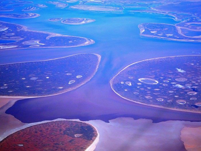
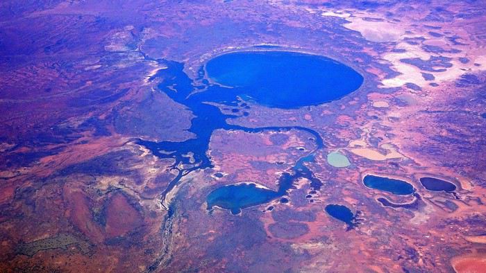
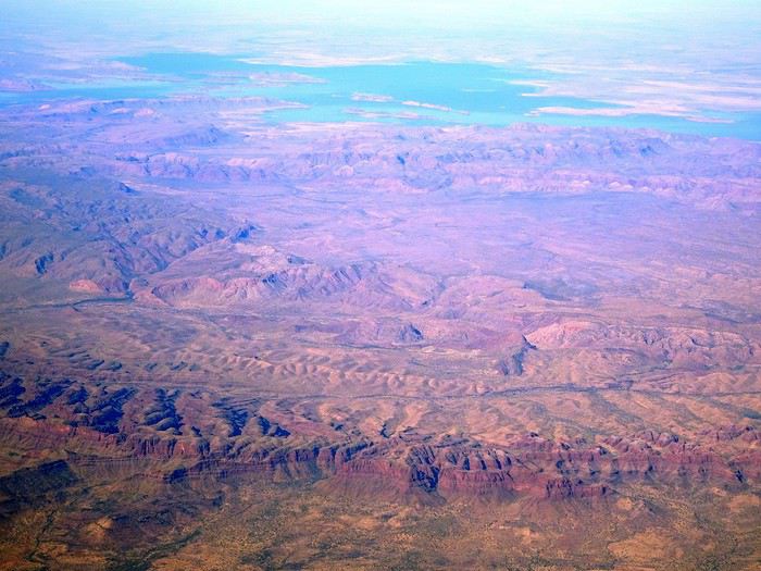
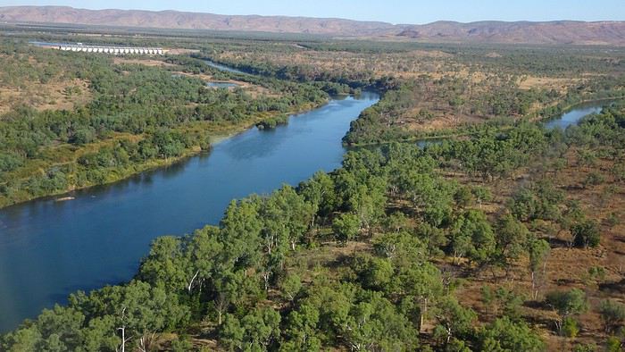
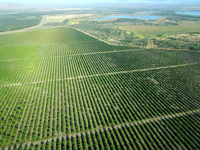
Just before landing, rows of green fields briefly appeared, along with an surprisingly wide river—but we were already rolling down the tarmac. A few hangars, a myriad of small, stationary planes, and a tiny terminal topped with a sign: “Welcome to Kununurra.”
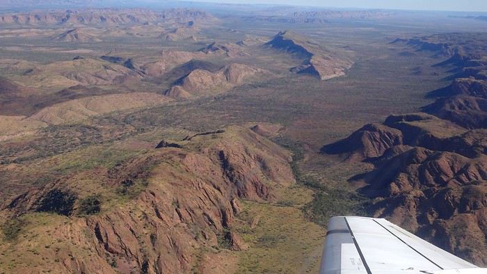
We wanted heat, and here it was—34°C the moment we stepped off the plane! We felt alive again and totally ridiculous in our jeans and sweaters. We quickly grabbed our suitcase and picked up the 4x4 we’d rented—more out of necessity, since only that type of vehicle can access the national parks we planned to visit.
Just four kilometers separated us from Kununurra, a town of 5,000 people founded in 1961 during the construction of the Lake Argyle Dam and the development of the Ord River Irrigation Area Scheme (more on that later). On the horizon, mountain ranges (a bit of an exaggeration, since we know Mt. Meharry, WA’s highest ‘mountain,’ doesn’t even reach 1,250 meters!) and closer to the road, a few irrigation canals cutting through stretches of bush, then a huge park overlooking a small lake lined with reeds.
A row of baobabs (yes, there are baobabs in Australia too!), a series of motels with immaculate lawns, a gas station, and there’s the main street leading to the town center—that is, the parking lots of the two supermarkets, the bottleshop, the pub, the Town Hall, the municipal pool, and the Tourist Office (already closed!), and at the next roundabout, another park, the Presbyterian church, and a few other shops. In short, two or three green blocks that you can explore in no time.
One road leads to the small industrial area and one of the town’s three or four campgrounds, while another heads toward the residential neighborhoods, which look just like the typical suburbs you find in any Australian city—except with tropical vegetation. We stocked up at Coles, an identical copy of the one near our place, and—surprise—the prices were practically the same.
We checked into one of the motels. The receptionist listed the town’s three or four restaurants, insisting that it’s always better to book a table. She recommended the Pump House, a bit outside town on the lake’s edge. “Best spot to watch the sunset, but hurry up.” she told us. It was only 5:00 PM!
When we got there half an hour later, the place was packed, and the sun had already disappeared behind a row of trees! Sure enough, we’d see a few days later that the sunset can be a stunning spectacle—if you wait a bit for the sky (especially if it’s cloudy) to blaze and reflect in the lake’s calm waters. A little disappointed, we headed back into town, where we easily found the other lively spot in town: the pub (nothing like an old English pub). Above the long L-shaped bar, several giant screens (thankfully muted) were broadcasting live footy, rugby league, etc. In one corner, players circled the pool table, while in another, customers were digging into plates of the day’s special. Instead of rooms, there were various patios where groups of friends and coworkers (easily recognizable by the fluoro vests they were still wearing) were gathered. We found a table under a mango tree—unfortunately, a little too close to the guitarist strumming his entire Country Music repertoire, complete with Keith Urban-style tremolos. Guaranteed culture shock!
Since it’s the custom here, we called the Country Club to book a table before the kitchen closed! The CC is the town’s—and even the region’s—fancy spot. Dark decor, modern furniture, dim lighting, and the air conditioning blasting. The twenty or so customers had taken refuge on the vast terrace, lit by torches. The view of the tall eucalyptus trees, illuminated by spotlights shifting from red to blue, was breathtaking.
The menu was minimal, but the grilled salmon was excellent, and the Pavlova (the meringue dessert Kiwis and Aussies have been arguing over since 1906) with melon and watermelon was absolutely divine.
It wasn’t even 9:00 PM, and we were already in bed. Had we already adopted the Top West End’s chicken schedule?!
To be continued... Journal dedicated to Attila
As usual, I didn’t manage to keep it short, but this time I’ve got photos to go with it!
August 2020. Since the opportunities to explore the world are extremely limited right now, all we (R&X) can do is explore our own island! Well, just a part of it, because with the state borders still closed, we’re stuck in Western Australia (WA).
Luckily, we’re pretty fortunate because this state is huge: over 2.5 million km² (that’s more than four times the size of France or 1.5 times Quebec). What’s more, stretching over 20 degrees of latitude between the Antarctic Ocean and the Timor Sea, you’ll find climates ranging from Mediterranean to arid to tropical. That’s actually why we decided to head as far north as possible. Sick of the endless rainy winter in Perth, bring on the heat of the Kimberley... way up Nooorth!
Friday. At the airport, the main terminal was closed (not enough flights), so we ended up in the annex (where flights to the various mines usually depart from). There was no crowd at the gate, and in this huge, single departure lounge, empty seats were plentiful. Only three flights were listed on the screens for the rest of the morning: the first to Coondewanna (?), the second to Darwin, and ours to Kununurra (code KNX).
A cool breeze swept through the half-open corridors along the runways. At the top of the walkway leading to the Fokker 100 (the Airbuses and Boeings are now parked!), a flight attendant greeted us with a basket full of sanitary masks. We were actually the only masked passengers (the staff weren’t wearing them either). With zero Covid-19 cases in WA at the time, the only rule was to maintain social distancing—something pretty hard to do on a full plane!
It was also my first time wearing a mask—it felt weird, pretty uncomfortable, and after a while, painful behind the ears. I really feel for those who have to wear one all day, every day. The flight lasted three long hours, but luckily, I had a good book. From the window, I watched an endless expanse of salt lakes in all shapes and sizes—round, elongated, gray, white, sometimes blue and green—and an infinity of winding, capricious meanders, along with long straight lines that led nowhere. The last half-hour got more interesting as rocky, swollen formations and long, sloping plateaus appeared. Against the vast ochre landscape, green patches became more frequent.
Just before landing, rows of green fields briefly appeared, along with an surprisingly wide river—but we were already rolling down the tarmac. A few hangars, a myriad of small, stationary planes, and a tiny terminal topped with a sign: “Welcome to Kununurra.”
We wanted heat, and here it was—34°C the moment we stepped off the plane! We felt alive again and totally ridiculous in our jeans and sweaters. We quickly grabbed our suitcase and picked up the 4x4 we’d rented—more out of necessity, since only that type of vehicle can access the national parks we planned to visit.
Just four kilometers separated us from Kununurra, a town of 5,000 people founded in 1961 during the construction of the Lake Argyle Dam and the development of the Ord River Irrigation Area Scheme (more on that later). On the horizon, mountain ranges (a bit of an exaggeration, since we know Mt. Meharry, WA’s highest ‘mountain,’ doesn’t even reach 1,250 meters!) and closer to the road, a few irrigation canals cutting through stretches of bush, then a huge park overlooking a small lake lined with reeds.
A row of baobabs (yes, there are baobabs in Australia too!), a series of motels with immaculate lawns, a gas station, and there’s the main street leading to the town center—that is, the parking lots of the two supermarkets, the bottleshop, the pub, the Town Hall, the municipal pool, and the Tourist Office (already closed!), and at the next roundabout, another park, the Presbyterian church, and a few other shops. In short, two or three green blocks that you can explore in no time.
One road leads to the small industrial area and one of the town’s three or four campgrounds, while another heads toward the residential neighborhoods, which look just like the typical suburbs you find in any Australian city—except with tropical vegetation. We stocked up at Coles, an identical copy of the one near our place, and—surprise—the prices were practically the same.
We checked into one of the motels. The receptionist listed the town’s three or four restaurants, insisting that it’s always better to book a table. She recommended the Pump House, a bit outside town on the lake’s edge. “Best spot to watch the sunset, but hurry up.” she told us. It was only 5:00 PM!
When we got there half an hour later, the place was packed, and the sun had already disappeared behind a row of trees! Sure enough, we’d see a few days later that the sunset can be a stunning spectacle—if you wait a bit for the sky (especially if it’s cloudy) to blaze and reflect in the lake’s calm waters. A little disappointed, we headed back into town, where we easily found the other lively spot in town: the pub (nothing like an old English pub). Above the long L-shaped bar, several giant screens (thankfully muted) were broadcasting live footy, rugby league, etc. In one corner, players circled the pool table, while in another, customers were digging into plates of the day’s special. Instead of rooms, there were various patios where groups of friends and coworkers (easily recognizable by the fluoro vests they were still wearing) were gathered. We found a table under a mango tree—unfortunately, a little too close to the guitarist strumming his entire Country Music repertoire, complete with Keith Urban-style tremolos. Guaranteed culture shock!
Since it’s the custom here, we called the Country Club to book a table before the kitchen closed! The CC is the town’s—and even the region’s—fancy spot. Dark decor, modern furniture, dim lighting, and the air conditioning blasting. The twenty or so customers had taken refuge on the vast terrace, lit by torches. The view of the tall eucalyptus trees, illuminated by spotlights shifting from red to blue, was breathtaking.
The menu was minimal, but the grilled salmon was excellent, and the Pavlova (the meringue dessert Kiwis and Aussies have been arguing over since 1906) with melon and watermelon was absolutely divine.
It wasn’t even 9:00 PM, and we were already in bed. Had we already adopted the Top West End’s chicken schedule?!
To be continued... Journal dedicated to Attila
Préparer son voyage à vélo ou improviser, vous faites comment?
Salut à tous,
On voit bien que tous les vélos permettent de voyager, pourvu qu'on ai l'envie , quoi que selon les itinéraires certains vont mieux que d'autres...
Autre sujet de partage d'expérience: la préparation
- Préparation de l'itinéraire, êtes vous du genre à tout planifier à l'avance ? (les hébergements , les étapes etc) ou bien "a l'aventure", "on verra bien" ? - Préparation des sacoches , le listing sur excell ! ou au pif et on oublie toujours un truc ? - Fana d'électronique (genre tableau de bord d'Airbus) avec GPS , smartphone, compteur ... ou Carte papier à l'ancienne ? - Etes vous du genre inquiet avec 5kg d'outillage, 3 chambres à air et un pneu de rechange pour la "Loire à vélo" ou bien un multi outil et une chambre à air pour la route de la soie ? - Les trucs indispensables à prendre pour vous c'est : une chaise, une table, 10kg de fringues et 3 paires de chaussures ? ou bien juste une tenue de rechange, des tongs pour l'étape soit 10kg tout compris ? - La photo pour vous c'est : 1) rien du tout, 2) un smartphone, ou 3) un reflex, 3 objectifs et un trépied ?
Voila je vous laisse nous raconter ...
Autre sujet de partage d'expérience: la préparation
- Préparation de l'itinéraire, êtes vous du genre à tout planifier à l'avance ? (les hébergements , les étapes etc) ou bien "a l'aventure", "on verra bien" ? - Préparation des sacoches , le listing sur excell ! ou au pif et on oublie toujours un truc ? - Fana d'électronique (genre tableau de bord d'Airbus) avec GPS , smartphone, compteur ... ou Carte papier à l'ancienne ? - Etes vous du genre inquiet avec 5kg d'outillage, 3 chambres à air et un pneu de rechange pour la "Loire à vélo" ou bien un multi outil et une chambre à air pour la route de la soie ? - Les trucs indispensables à prendre pour vous c'est : une chaise, une table, 10kg de fringues et 3 paires de chaussures ? ou bien juste une tenue de rechange, des tongs pour l'étape soit 10kg tout compris ? - La photo pour vous c'est : 1) rien du tout, 2) un smartphone, ou 3) un reflex, 3 objectifs et un trépied ?
Voila je vous laisse nous raconter ...
La Bretagne avec le Jacques Cartier "Ponant" du 18 au 25 juillet 2020
Bonjour
J'avais envisagé d'attendre début Octobre et notre retour à Rennes pour faire le C/R
de notre croisière " La Bretagne : entre côtes sauvages et phares "
Mais tout compte fait , je change d'avis et démarre ce C/R dès maintenant :
Au retour de notre 20 ème croisière , fin Novembre 2019 , ( Transat de Marseille à
Miami sur le MSC Divina ) , nous avions décidé de faire une (petite ) pause pour les
croisières et donc de ne rien réserver avant plusieurs mois .
Sage décision en fait au vu des évènements sanitaires du Printemps puisque nous
avons échappé aux problèmes subis par nombre de touristes qui se sont retrouvés
avec des avoirs qu'il ne pourront utiliser ( au mieux ) que dans plusieurs mois .
A la fin de l'an dernier , je m'étais inscrit à la newsletter de Ponant , plus pour rêver
qu'autre chose .
Mais début Juin , alors que toutes les croisières sont annulées les unes après les autres ,
Ponant , profitant notamment de la capacité réduite de ses navires et du retour en
France métropolitaine de presque tous , met en place 2 itinéraires en Méditerranée et
3 en Manche et Atlantique .
La croisière au départ de Nice pour contourner la Corse nous plaisait bien mais rejoindre
Nice posait , à ce moment là , problème .
Nous décidons donc de nous rabattre sur la croisière au départ de St Malo car là , pas de
souci pour nous y rendre 🙂
Les raisons de notre choix : de mémoire , St Malo est fréquemment une ville d'escale pour
les bateaux de croisière mais quasiment jamais une ville d'embarquement ( et là aussi
de débarquement ) , donc autant en profiter .
De plus l'itinéraire nous plait avec la visite d'iles connues ( mais que nous reverrons avec
plaisir ) et de vraies découvertes dont les Scilly , au large de la Cornouaille britannique .
Mi Juin , nous décidons de réserver la croisière au départ de St Malo du 18 Juillet , sachant
que nous avons la possibilité d'annuler , sans pénalités , jusqu'à 72 heures avant le départ .
L'annulation , nous y avons pensé quand , fin Juin , nous avons appris que l'escale aux
Scilly était supprimée 😠 , remplacée par Ouessant , une escale à Groix se substituant
à celle de Hoëdic .
Toutes les autres croisières étaient aussi affectées par la suppression des escales à l'étranger
pour raisons sanitaires ( jours de quarantaine )
Nous trouverons donc peut-être une autre occasion pour nous rendre aux Scilly
Comme d'habitude , je m'égare avec ce préambule un peu long .
Je vais donc faire une pause avant de vous embarquer sur le Jacques Cartier .
A plus
Jean-Pierre
Voyage organisé en séjour tout compris au Japon
Bonjour
L'agence de voyage TUI organise des sejours tout compris au JAPON.pour 26 personnes max
Merci de faire des retours d'impression si vous avez des infos
bonne journée
Michel
Changement de navire sur croisière déjà réservée
Bonsoir
Pour notre croisière de décembre 2020 sur le Msc Seaview (Dubai) Msc change de bateau ca sera le Msc Fantasia.
Puis je annuler cette croisière pour cette raison ?
Merci et bonne soirée à vous.
Recharge de gaz au Népal (à Tumlingar)
Bonjour à tous,
j'aimerai faire un trek au Népal entre tumingtar et lukla en passant par le sherpani pass, et le mera la puis lukla en autonomie avec un ami.
Pour les 3,4 jours d'autonomie en repas que nécessite ce trek, j'ai besoin de savoir quel carburant je prends, soit un réchaud essence ou un rechaud en gaz. J'aimerai donc savoir si il est possible de trouver de petites recharges de gaz à tumlingtar étant donné que normalement on ne peut transporter ce genre de bouteilles en avion.
Merci d'avance pour vos réponses
sportivement
Jérôme
Cuba, Cuba, si...
Confinement aidant, la décantation est opérée, comme disent mes voisins vignerons, notre récent voyage à Cuba en début d’année peut désormais être dégusté : Le cru de ce voyage 2020 est excellent !!!
Une volonté de changer de cap pour renouer avec une zone régionale, une culture latino et une histoire politique et sociale, négligées depuis plus de 3 décennies me titillait depuis quelques temps….
Alors, direction les Caraïbes, le pays de Cespedes et Marti pour 24 jours entre janvier et février.
Comme d’habitude, pas mal de lectures, sur VF notamment (grands mercis à Jeeaan, https://voyageforum.com/v.f?post=7694939;#7694939, à Ming2 pour ses 2 carnets en particulier https://voyageforum.com/v.f?post=6977052;#6977052et https://voyageforum.com/v.f?post=7425832;#7425832; à Anne42 https://voyageforum.com/discussion/trois-semaines-havane-baracoa-d8719358/ ainsi quà Stbeat), de blogs, d’articles divers, et de guides avaient permis de fixer un planning très général, avec pour commencer après une courte découverte de La Havane, direction l'Oriente et Baracoa par un vol intérieur pour une petite semaine.
Seules les 2 premières nuits à La Havane en "casa particular", avec vue sur le mythique Malecon, étaient réservées, ainsi que les 6 jours suivants chez Roberto et Manuel à Baracoa.
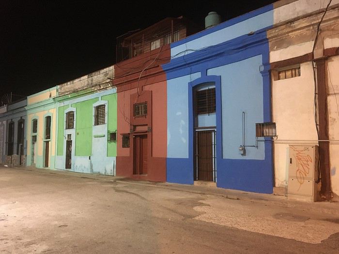
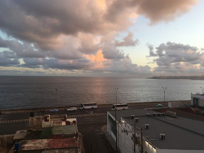
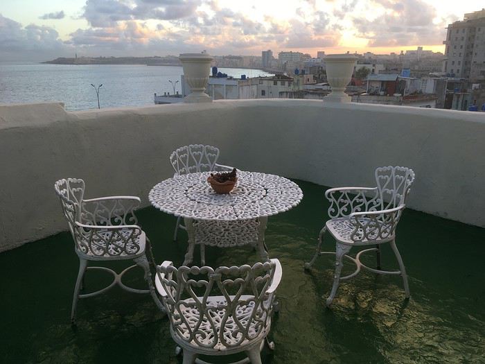
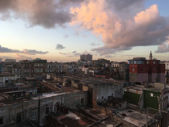
Premier réveil (dur, dur) cubain depuis la terrasse de la casa, après une très courte nuit (et jetlag) , dont la première partie fut passée à la Fabrica del Arte (http://www.fac.cu/) où le festival de jazz attirait une foule très éclectique !
Une volonté de changer de cap pour renouer avec une zone régionale, une culture latino et une histoire politique et sociale, négligées depuis plus de 3 décennies me titillait depuis quelques temps….
Alors, direction les Caraïbes, le pays de Cespedes et Marti pour 24 jours entre janvier et février.
Comme d’habitude, pas mal de lectures, sur VF notamment (grands mercis à Jeeaan, https://voyageforum.com/v.f?post=7694939;#7694939, à Ming2 pour ses 2 carnets en particulier https://voyageforum.com/v.f?post=6977052;#6977052et https://voyageforum.com/v.f?post=7425832;#7425832; à Anne42 https://voyageforum.com/discussion/trois-semaines-havane-baracoa-d8719358/ ainsi quà Stbeat), de blogs, d’articles divers, et de guides avaient permis de fixer un planning très général, avec pour commencer après une courte découverte de La Havane, direction l'Oriente et Baracoa par un vol intérieur pour une petite semaine.
Seules les 2 premières nuits à La Havane en "casa particular", avec vue sur le mythique Malecon, étaient réservées, ainsi que les 6 jours suivants chez Roberto et Manuel à Baracoa.
Premier réveil (dur, dur) cubain depuis la terrasse de la casa, après une très courte nuit (et jetlag) , dont la première partie fut passée à la Fabrica del Arte (http://www.fac.cu/) où le festival de jazz attirait une foule très éclectique !
Memories of Thailand
ko samui
Romans iraniens contemporains
Bonsoir,
L'un ou l'une d'entre vous a-t-il un ou des titres de roman iranien contemporain à me conseiller?
Auteur iranien et pas auteur qui écrit sur l'Iran. Et de préférence masculin (il faut que je me rende à l'évidence, ma longue expérience de lectrice montre que je ne suis pas du tout réceptive à la littérature écrite par des femmes).
Khayyam et Hafez, guère contemporains, sont déjà dans ma bibliothèque. Maalouf, qui au demeurant n'est pas iranien, aussi.
Catherine
L'un ou l'une d'entre vous a-t-il un ou des titres de roman iranien contemporain à me conseiller?
Auteur iranien et pas auteur qui écrit sur l'Iran. Et de préférence masculin (il faut que je me rende à l'évidence, ma longue expérience de lectrice montre que je ne suis pas du tout réceptive à la littérature écrite par des femmes).
Khayyam et Hafez, guère contemporains, sont déjà dans ma bibliothèque. Maalouf, qui au demeurant n'est pas iranien, aussi.
Catherine
On the Silk Road: Chronicles of a Sixty-Something Traveling Completely Independently
From Beijing to Khiva: China, Kyrgyzstan, Tajikistan, Uzbekistan
Chronicle of anecdotes, highlights, and other adventures that marked this eight-week journey in 2018.
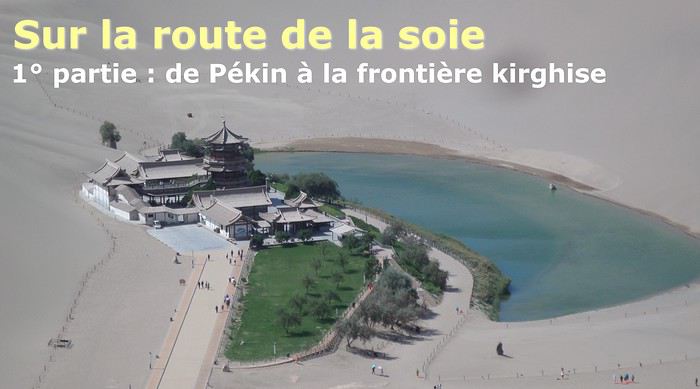
The Chinese Far West More than 30 years after my first trip to eastern China, I finally fulfilled an old dream: traveling solo from Beijing to the far west, discovering Xinjiang, the Uyghur people and the oppression they endure, the oases of Turpan and Kashgar, the Taklamakan Desert, the end of the Great Wall... The route was covered by train.
MENU PART 1: CHINA
1- Beijing (Jiankou) : the authentic Great Wall, without tourists 2- Cycling in Beijing, the best way to get around 3- Beijing : departure for the far west 4- Jiayuguan : getting by without English 5- Jiayuguan : scams and heritage 6- Dunhuang : abundance in the middle of the desert 7- Turpan : the Uyghurs under heavy surveillance 8- Kashgar : love at first sight for the old city 9- Kashgar : China’s recipe for controlling the populace 10- Tashkurgan : what on earth was I thinking going there! Kyrgyz border: a surreal epic Photo album from the 80s, contributions from other travelers (page 2)
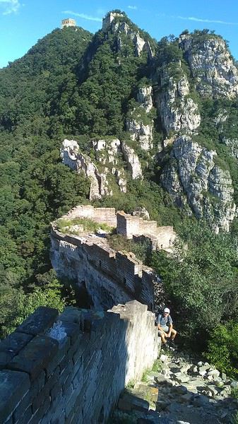
1- JIANKOU Finding the authentic Great Wall, without tourists or a guide Friday, August 24, 2018 Thirty years later, I didn’t feel like revisiting the Great Wall at Badaling or any other overcrowded site. I chose to explore it at Jiankou, in its wildest, most authentic, and unrestored section, starting from a lost village deep in a valley—though it wasn’t *that* lost, since it had everything for communication.
No need to pay for a taxi to get there—by timing it right, you can take the bus for just a few yuan. You have to get off at Xizhazi, the bus terminus. Be careful, there are only two buses a day in each direction. At the Xizhazi bus stop, I met a young couple who’d arrived with zero information about what to expect. We hiked the three of us toward the restored section of Mutianyu.
Still, be cautious With GPS and a topographic map (OpenTopoMap), you can set off without a problem or guide. The trail up to Jiankou is easy and well-marked. The trails down are too. But be careful—once you’re on the Wall, it’s real mountain hiking, with easy but dangerous climbing sections (over sheer drops). Not for amateurs or those afraid of heights! But what a reward. The Wall all to yourself, where it’s at its most daring. Truly mesmerizing.
More photos...
2- BEIJING The best way to get around the capital Sunday, August 26 The best way to explore the city is still by bike. Most are in a bike-share system, but you need to use an app—WeChat, the app that does everything, like monitoring your every move. No way I was installing that.
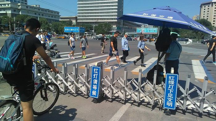
I found one at a rental shop near the hostel. The key is to quickly learn local traffic customs to minimize risks. Bike lanes are wide along the avenues.
But you still have to: - Watch out for anything parked on the bike paths—the most annoying are people napping or talking on the phone in their cars - Keep an eye on everything coming the wrong way—the list is long - The worst is right turns on red, which in Chinese traffic rules seem to have priority Once you get the hang of it, it’s fine. The city is huge but flat, so you can just wing it.
3- BEIJING By train to the far west Sunday, August 26 Beijing West Station is the size and operates like an airport. With your e-ticket from the agency, you first have to pick up your ticket at the special "English" counter, after passing through security. With your ticket in hand, you have to exit and enter through the boarding waiting area—not the platform—after a second security check.
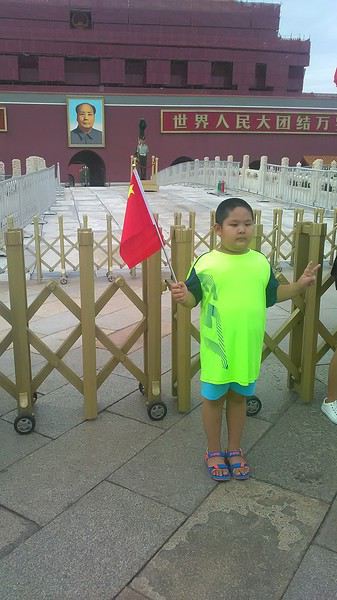 Then you find the right hall and wait for the sign to finally access the platform. In the end, it works pretty well given the incredible number of passengers to manage. Everywhere in Beijing, I saw that the Chinese have mastered crowd flow management.
Nice surprise: second-class carriages are clean, air-conditioned, and bright. Perfect, since I was in for 20 hours. One uniformed attendant per carriage, mobile meal service—luxury! Small downside: no luggage space. Hauling your suitcase up to the top bunk is quite a workout. I was in the middle, so it wasn’t too bad. The landscape, though, whether rural or urban, is pretty bleak. That should change once we leave the eastern plains.
Of course, I got my first police visit, with a thorough passport check and bag search. I was warned—going to the Chinese far west exposes you to this kind of hassle. But they were polite and respectful.
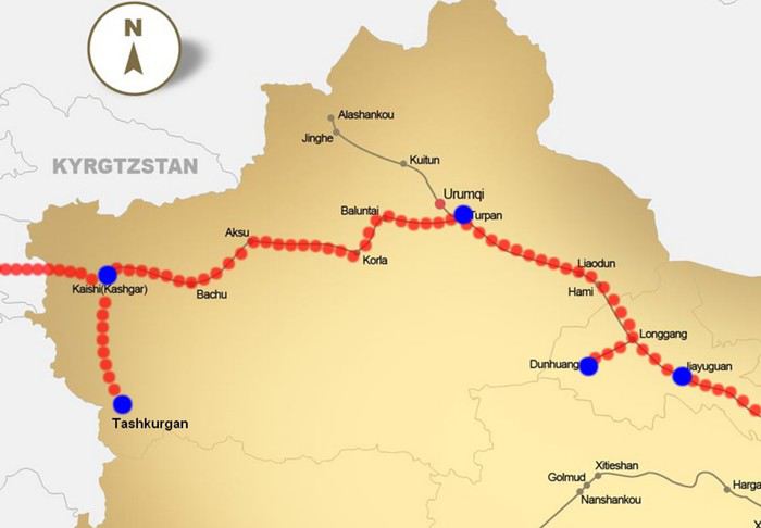 The Chinese Far West
4- JIAYUGUAN Getting by without English Monday, August 27 At the gates of two deserts (Gobi and Taklamakan) and at the foot of the Tibetan highlands, the Great Wall ends at Jiayuguan. Here, I found the deeper China I’d somewhat rediscovered during my bike ride, even if now everyone gets around on electric bikes and I’m no longer stared at like an alien.
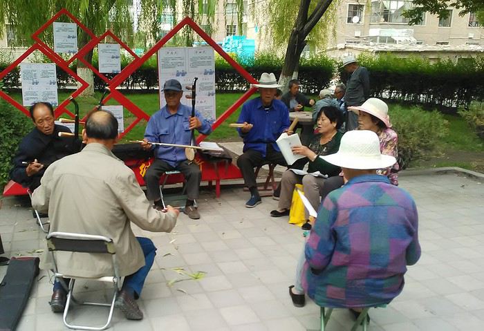
Prices are nothing like Beijing: you can find a full meal for 2 €, and my bike cost 7 € for two days. Plus, few people speak English—neither the owner of the HI hostel where I stayed, nor the ticket sellers at the sites, let alone the servers at the small eateries where I ate. Everything is written in Chinese. So I had to use the little Chinese I know to communicate about essentials. It makes the locals laugh to see a European trying to speak their language, but it earns respect. With Google Translate’s help, I managed.
Rant: With their avenues blocked for construction for kilometers without warning, and new roads not yet on maps, I must’ve taken 15 km of detours. More photos...
5- JIAYUGUAN Scams and heritage Tuesday, August 28 The Great Wall doesn’t exactly end at the fort I visited yesterday but 10 km further, at the entrance to a river gorge at the foot of the mountains. All that’s left is a badly damaged tower (more like a mound of earth) and a section of clay wall, similar to the one I biked yesterday.
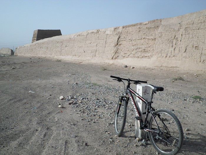
This morning, I hopped on my bike, determined to venture into the desert to see this highly symbolic site. First, you access it via a wide, brand-new road with not a soul in sight. Just before the site, I came across a grand welcome gate, very period-style, but it’s actually the inevitable toll booth.
Behind the gate, the road continues straight to the site, which you can see in the distance—at least 2 km away—the remains of the tower and wall. I had to leave my bike here. Fine. I went to the ticket counter and asked the price: 120 yuan! I couldn’t believe it—over 15 € for a simple mound of earth.
I showed my displeasure to the attendant, who couldn’t care less, and immediately turned back. 120 yuan—that’s the price for a new road, a fancy gate planted 2 km before the site just to force you to take a shuttle, and employees with nothing to do all day... Now I understand why I didn’t meet anyone!
Heritage China is a bit pricey Generally, sites are expensive for the country’s standard of living, but travelers are supposed to have money, so why hold back? I even gave up on the Forbidden City—reservations required days in advance (or on the black market at an impossible price). I prefer to keep the memory of my first visit, when entry must’ve cost a few dozen cents, and there were only a handful of visitors.
This morning, I took a taxi to see remarkable tombs of common people from the 3rd to 6th centuries. They’re small vaulted caves made of painted bricks, depicting scenes of daily life. Very pretty and moving. But even here, though the price was more reasonable, I was left wanting—only one of the 16 tombs is open to visitors, and it’s apparently not the most beautiful.
The authentic China—at least what’s left of it... Wandering the impersonal avenues of the city, you stumble upon a market. There, you still find traditional China—small shops with questionable hygiene, Go players, musicians, and even a dental prosthetist. The last refuge for those untouched by modernity. More photos...
6- DUNHUANG Abundance in the middle of the desert Wednesday, August 29 Well, I thought the landscape would be less bleak as I headed west. Nope. The only distraction in this expanse of dark, clayey sand is the forests of pylons and wind turbines, plus wild camels racing each other.
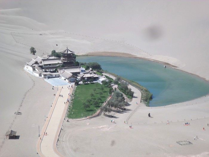 However, Dunhuang, the gateway to the Taklamakan, is by far the most pleasant Chinese city I know. There’s a real city center you can explore on foot. It’s hot but not unbearable, with a light, dry breeze. Much nicer than Beijing. The Han Chinese are still the majority, but the Muslim Uyghurs are more numerous, and the muezzin’s call to prayer echoes around the mosque.
The most surprising thing is the abundance and diversity of fruits and vegetables. You wonder how it all grows here. Well-irrigated, the desert sands are very fertile. Here, raisins have subtle, mysterious flavors, and the lamb really tastes like lamb.
Today, I visited the must-see Mingshashan, a dune complex next to which Pila is a molehill. The Basque Country, but covered in sand... More photos...
7- TURPAN The Uyghurs under heavy surveillance Friday, August 31 Surveillance cameras everywhere in the city, armed police stationed at intersections, in front of public buildings, at the entrance and inside tourist sites, police stations on every corner, patrols on foot or by car, khaki uniforms even for middle schoolers... here, the Han Chinese are in the minority, and you can feel it. Turpan feels like a city under siege.
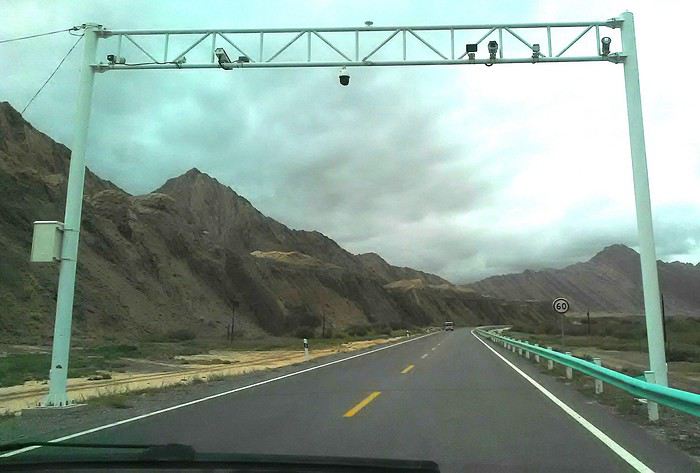
To enter the youth hostel where I stayed, there’s even a security gate, and the receptionist (a Han, like everyone in tourism) wears a bulletproof vest! Reassuring. Still, you don’t feel particularly threatened here, especially as a European. The troublemakers are the Chinese, not the Uyghurs. Generally, China is a very safe country for visitors.
Smile, you’re on camera! I was biking on an avenue when the car in front of me got flashed for driving slowly. I quickly understood why when I got flashed too.
Here, the official time is Beijing time, but it gets dark two hours later. It’ll be even worse in Kashgar. Trickier to manage: everything is displayed in Chinese and Arabic. Nothing in English. Choosing a menu is a shot in the dark. Apart from a few young Chinese, no one here speaks English, and my Chinese doesn’t seem very understandable...
Mogao, the end of the road for the Han Yesterday, near Dunhuang, I went to Mogao, a complex of decorated caves with Buddha sculptures and paintings. Stunning, but so crowded! Luckily, here in Turpan, Chinese tourists barely venture out. So I visited a Silk Road ghost town with only a handful of other visitors and under a howling wind.
The modern Chinese city is swallowing up the old Uyghur neighborhoods—only a museum-like district remains in the center, and pockets of resistance on the outskirts are doomed to disappear soon. More photos...
8- KASHGAR A (relative) love at first sight for the old city Sunday, September 2 After three overnight trains, here I am in the far west of China, nearly 4,000 km from the capital. Despite the omnipresent police and an old city preserved UNESCO-style, Kashgar is my Chinese love at first sight.
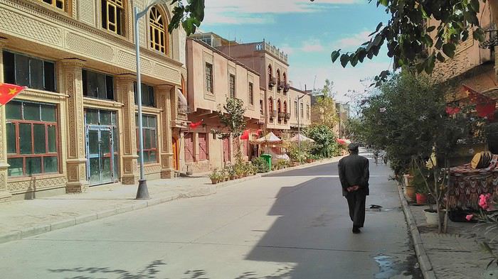
Finally, Chinese... well, sort of, because we’re in Uyghur territory here—a Turkic people with nothing culturally in common with the Han, the eastern Chinese. It started badly yesterday at Turfan station, where after three security gate passes, at least five passport checks, and a bag search, three adorable policewomen confiscated my antibacterial lotion because it had a flammable logo...
Then came the welcoming committee of armed cops at Kashgar station. Once all that was over, they left me alone—except you still have to go through security checks like everyone else to enter the old city, the bazaar, the livestock market... The further west you go, the more the siege mentality is evident. Luckily, the border isn’t far...
Despite the inevitable destruction-reconstruction, the city center has been well preserved. Thankfully, because it’s a very original style, a mix of local and colonial. I love it, even if it’s a bit too artificial, sanitized, and watered-down, and rather empty of residents. On the Silk Road, the city was famous for its great food. And it still is—rarely have I seen such richness and abundance of food! And not just scorpions or snakes. More photos...
9- KASHGAR China’s recipe for controlling the populace Saturday, September 1 Xinjiang, along with Tibet, is a "sensitive" area of rebellion in the eyes of Chinese authorities. As a result, the state has these regions and their populations under total control. Tourists also feel the consequences, even if they’re not at risk of re-education camps.
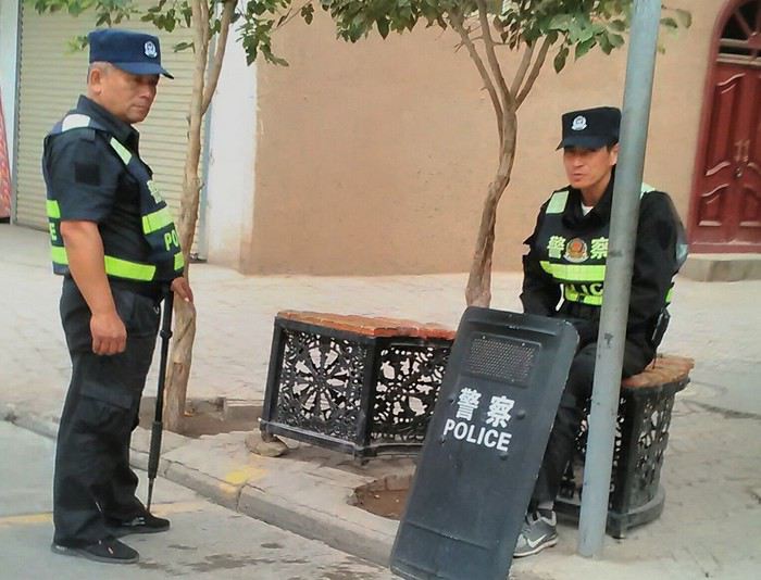 - Putting barbed wire and anti-ramming barriers around sensitive sites (schools, big hotels, government buildings...)
- Installing traffic surveillance gates with cameras and photo flashes (for all vehicles passing, including bikes) throughout the city and even in the countryside
- Posting uniformed guards with tasers, batons, or huge baseball bats every 100 meters
- Training the Han population (ethnic Chinese) in self-defense with sticks, preferably in the morning on the street. Men and women of all ages
- Starting school with the national anthem, doing military exercises, and receiving political indoctrination, all neatly lined up in the courtyard. (The dream school for any teacher)
- Placing a snitch in uniform (a pseudo-guard) in public gathering places, like youth hostels. Mine spends the day loafing around the courtyard
- Putting Chinese flags everywhere on the streets to remind everyone who’s in charge
- Installing security gates at every entrance to areas frequented by tourists (thanks for that) but not just there
- Never photographing cops, or else! I tried, but it’s not easy...
- Putting barbed wire and anti-ramming barriers around sensitive sites (schools, big hotels, government buildings...)
- Installing traffic surveillance gates with cameras and photo flashes (for all vehicles passing, including bikes) throughout the city and even in the countryside
- Posting uniformed guards with tasers, batons, or huge baseball bats every 100 meters
- Training the Han population (ethnic Chinese) in self-defense with sticks, preferably in the morning on the street. Men and women of all ages
- Starting school with the national anthem, doing military exercises, and receiving political indoctrination, all neatly lined up in the courtyard. (The dream school for any teacher)
- Placing a snitch in uniform (a pseudo-guard) in public gathering places, like youth hostels. Mine spends the day loafing around the courtyard
- Putting Chinese flags everywhere on the streets to remind everyone who’s in charge
- Installing security gates at every entrance to areas frequented by tourists (thanks for that) but not just there
- Never photographing cops, or else! I tried, but it’s not easy...
With all that, you can stroll around safely Not much crime! As for the amount the Chinese state spends to maintain such a system, it’s staggering! A third of the Han living in Xinjiang work in security. Today, I wandered freely around old Kashgar, which is quite large after all. More photos...
10- TASHKURGAN What on earth was I thinking going there! Wednesday, September 5 First, there’s the taxi—pretty crappy, with a driver who doesn’t speak a word of English and won’t stop smoking. Over six hours in that... shared with a completely out-of-it American.
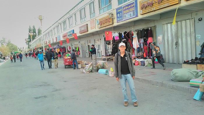
Then there are all the checkpoints along the way. I won’t go on—you know the drill by now.
After that, there’s Tashkurgan—a town with nothing to see, nothing to do. Deserted as soon as night falls. There’s this huge youth hostel and a few lost Chinese tapping away on their smartphones, chain-smoking. This lost American-European crowd, swapping tips on how to enter Pakistan or Tajikistan.
Luckily, there’s the Chinese Pamir Highway, lined with peaks over 7,000m. There’s the feeling of no longer being in China, with a population whose features are Middle Eastern. And these Tajik women with their stunning hairstyles and vibrant costumes. There’s the fact of having reached the westernmost Chinese city, far from crowds and tourist sites. A sort of end of the world. More photos...
11- KYRGYZ BORDER A surreal epic Thursday, September 6 The road from Kashgar to the Kyrgyzstan border is a little over 200 km and passes through beautiful landscapes of colorful, desert-like mountains with acrobatic folds. That’s the bucolic part of the trip.
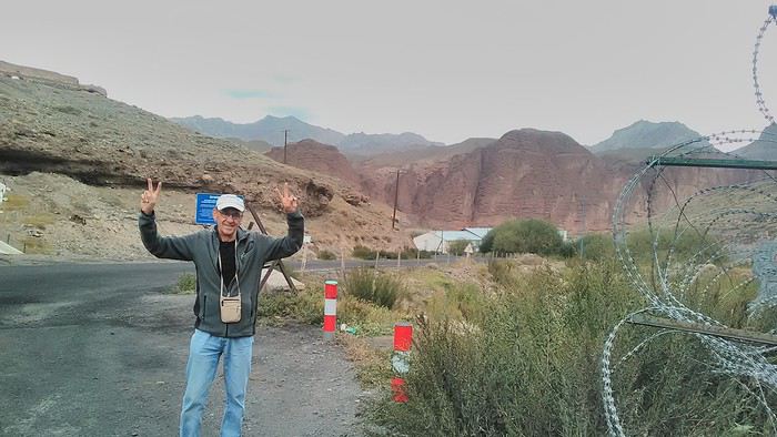 Yesterday, I managed to gather four people to rent a minibus to reach the border more easily: a Spaniard and an Argentine I’d already met in Turpan, and two New Zealanders who responded to the ad left at the hostel.
Absurdity and paranoia of Chinese authorities The highlight was crossing the town of Wuqia, 50 km past Kashgar. After tallying up with my fellow sufferers, we must’ve passed about ten checkpoints with: - Passport checks: 14 times, sometimes by two cops side by side - Bag checks: 4 times - Smartphone checks: 2 times, with deletion of "non-compliant" photos, and registration of your IMEI in the exit log!... Absurd and surreal at the same time, since my camera stayed in my bag, my apps are in French, and my photos have been online for ages...
With all that, we arrived just as the last checkpoint before the no man’s land marking the border between the two countries was on lunch break. And bam! Another 1.5-hour wait, alongside truckers who were much more used to this than we were.
What to think? The cops themselves aren’t fooled. They play the role they’re asked to, but sometimes you can coax a smile out of them—they realize how ridiculous the situation is.
What’s the point? That’s the big question my companions and I were tempted to answer with "to piss people off." To show you your place isn’t here, but with the other tourists, over there in the east, in Shanghai, Xi’an, or Guangzhou.
As for you, a traveler from a democratic country, you really experience this as aggression, humiliation, a violation of your private space. And yet, I’m respected, they speak to me properly. Today, I better understand what a Palestinian or a citizen of an occupied country might feel daily. A unique experience! Thanks, China.
And to top it off, the cherry on the cake! It’s still this glowing button you press to rate your passage after clearing the last obstacle before the exit stamp. I was so surprised it turned off before I could react. The Spaniard, with great humor and irony, had time to vote "excellent." In the end, he wasn’t wrong—you can hardly do better!
PS: I ditched my buddies at the border. They didn’t want to pay for a taxi to continue. So I took a direct taxi to Osh. The first 100 km are fabulous. I couldn’t take many photos, but I’ll be back on Monday to go to Tajikistan.
More photos...
The rest of the Silk Road, Part 2, in these travel journals: Kyrgyzstan, Tajikistan, Uzbekistan.
The Chinese Far West More than 30 years after my first trip to eastern China, I finally fulfilled an old dream: traveling solo from Beijing to the far west, discovering Xinjiang, the Uyghur people and the oppression they endure, the oases of Turpan and Kashgar, the Taklamakan Desert, the end of the Great Wall... The route was covered by train.
MENU PART 1: CHINA
1- Beijing (Jiankou) : the authentic Great Wall, without tourists 2- Cycling in Beijing, the best way to get around 3- Beijing : departure for the far west 4- Jiayuguan : getting by without English 5- Jiayuguan : scams and heritage 6- Dunhuang : abundance in the middle of the desert 7- Turpan : the Uyghurs under heavy surveillance 8- Kashgar : love at first sight for the old city 9- Kashgar : China’s recipe for controlling the populace 10- Tashkurgan : what on earth was I thinking going there! Kyrgyz border: a surreal epic Photo album from the 80s, contributions from other travelers (page 2)
1- JIANKOU Finding the authentic Great Wall, without tourists or a guide Friday, August 24, 2018 Thirty years later, I didn’t feel like revisiting the Great Wall at Badaling or any other overcrowded site. I chose to explore it at Jiankou, in its wildest, most authentic, and unrestored section, starting from a lost village deep in a valley—though it wasn’t *that* lost, since it had everything for communication.
No need to pay for a taxi to get there—by timing it right, you can take the bus for just a few yuan. You have to get off at Xizhazi, the bus terminus. Be careful, there are only two buses a day in each direction. At the Xizhazi bus stop, I met a young couple who’d arrived with zero information about what to expect. We hiked the three of us toward the restored section of Mutianyu.
Still, be cautious With GPS and a topographic map (OpenTopoMap), you can set off without a problem or guide. The trail up to Jiankou is easy and well-marked. The trails down are too. But be careful—once you’re on the Wall, it’s real mountain hiking, with easy but dangerous climbing sections (over sheer drops). Not for amateurs or those afraid of heights! But what a reward. The Wall all to yourself, where it’s at its most daring. Truly mesmerizing.
More photos...
2- BEIJING The best way to get around the capital Sunday, August 26 The best way to explore the city is still by bike. Most are in a bike-share system, but you need to use an app—WeChat, the app that does everything, like monitoring your every move. No way I was installing that.
I found one at a rental shop near the hostel. The key is to quickly learn local traffic customs to minimize risks. Bike lanes are wide along the avenues.
But you still have to: - Watch out for anything parked on the bike paths—the most annoying are people napping or talking on the phone in their cars - Keep an eye on everything coming the wrong way—the list is long - The worst is right turns on red, which in Chinese traffic rules seem to have priority Once you get the hang of it, it’s fine. The city is huge but flat, so you can just wing it.
3- BEIJING By train to the far west Sunday, August 26 Beijing West Station is the size and operates like an airport. With your e-ticket from the agency, you first have to pick up your ticket at the special "English" counter, after passing through security. With your ticket in hand, you have to exit and enter through the boarding waiting area—not the platform—after a second security check.
Then you find the right hall and wait for the sign to finally access the platform. In the end, it works pretty well given the incredible number of passengers to manage. Everywhere in Beijing, I saw that the Chinese have mastered crowd flow management.Nice surprise: second-class carriages are clean, air-conditioned, and bright. Perfect, since I was in for 20 hours. One uniformed attendant per carriage, mobile meal service—luxury! Small downside: no luggage space. Hauling your suitcase up to the top bunk is quite a workout. I was in the middle, so it wasn’t too bad. The landscape, though, whether rural or urban, is pretty bleak. That should change once we leave the eastern plains.
Of course, I got my first police visit, with a thorough passport check and bag search. I was warned—going to the Chinese far west exposes you to this kind of hassle. But they were polite and respectful.
The Chinese Far West4- JIAYUGUAN Getting by without English Monday, August 27 At the gates of two deserts (Gobi and Taklamakan) and at the foot of the Tibetan highlands, the Great Wall ends at Jiayuguan. Here, I found the deeper China I’d somewhat rediscovered during my bike ride, even if now everyone gets around on electric bikes and I’m no longer stared at like an alien.
Prices are nothing like Beijing: you can find a full meal for 2 €, and my bike cost 7 € for two days. Plus, few people speak English—neither the owner of the HI hostel where I stayed, nor the ticket sellers at the sites, let alone the servers at the small eateries where I ate. Everything is written in Chinese. So I had to use the little Chinese I know to communicate about essentials. It makes the locals laugh to see a European trying to speak their language, but it earns respect. With Google Translate’s help, I managed.
Rant: With their avenues blocked for construction for kilometers without warning, and new roads not yet on maps, I must’ve taken 15 km of detours. More photos...
5- JIAYUGUAN Scams and heritage Tuesday, August 28 The Great Wall doesn’t exactly end at the fort I visited yesterday but 10 km further, at the entrance to a river gorge at the foot of the mountains. All that’s left is a badly damaged tower (more like a mound of earth) and a section of clay wall, similar to the one I biked yesterday.
This morning, I hopped on my bike, determined to venture into the desert to see this highly symbolic site. First, you access it via a wide, brand-new road with not a soul in sight. Just before the site, I came across a grand welcome gate, very period-style, but it’s actually the inevitable toll booth.
Behind the gate, the road continues straight to the site, which you can see in the distance—at least 2 km away—the remains of the tower and wall. I had to leave my bike here. Fine. I went to the ticket counter and asked the price: 120 yuan! I couldn’t believe it—over 15 € for a simple mound of earth.
I showed my displeasure to the attendant, who couldn’t care less, and immediately turned back. 120 yuan—that’s the price for a new road, a fancy gate planted 2 km before the site just to force you to take a shuttle, and employees with nothing to do all day... Now I understand why I didn’t meet anyone!
Heritage China is a bit pricey Generally, sites are expensive for the country’s standard of living, but travelers are supposed to have money, so why hold back? I even gave up on the Forbidden City—reservations required days in advance (or on the black market at an impossible price). I prefer to keep the memory of my first visit, when entry must’ve cost a few dozen cents, and there were only a handful of visitors.
This morning, I took a taxi to see remarkable tombs of common people from the 3rd to 6th centuries. They’re small vaulted caves made of painted bricks, depicting scenes of daily life. Very pretty and moving. But even here, though the price was more reasonable, I was left wanting—only one of the 16 tombs is open to visitors, and it’s apparently not the most beautiful.
The authentic China—at least what’s left of it... Wandering the impersonal avenues of the city, you stumble upon a market. There, you still find traditional China—small shops with questionable hygiene, Go players, musicians, and even a dental prosthetist. The last refuge for those untouched by modernity. More photos...
6- DUNHUANG Abundance in the middle of the desert Wednesday, August 29 Well, I thought the landscape would be less bleak as I headed west. Nope. The only distraction in this expanse of dark, clayey sand is the forests of pylons and wind turbines, plus wild camels racing each other.
However, Dunhuang, the gateway to the Taklamakan, is by far the most pleasant Chinese city I know. There’s a real city center you can explore on foot. It’s hot but not unbearable, with a light, dry breeze. Much nicer than Beijing. The Han Chinese are still the majority, but the Muslim Uyghurs are more numerous, and the muezzin’s call to prayer echoes around the mosque.The most surprising thing is the abundance and diversity of fruits and vegetables. You wonder how it all grows here. Well-irrigated, the desert sands are very fertile. Here, raisins have subtle, mysterious flavors, and the lamb really tastes like lamb.
Today, I visited the must-see Mingshashan, a dune complex next to which Pila is a molehill. The Basque Country, but covered in sand... More photos...
7- TURPAN The Uyghurs under heavy surveillance Friday, August 31 Surveillance cameras everywhere in the city, armed police stationed at intersections, in front of public buildings, at the entrance and inside tourist sites, police stations on every corner, patrols on foot or by car, khaki uniforms even for middle schoolers... here, the Han Chinese are in the minority, and you can feel it. Turpan feels like a city under siege.
To enter the youth hostel where I stayed, there’s even a security gate, and the receptionist (a Han, like everyone in tourism) wears a bulletproof vest! Reassuring. Still, you don’t feel particularly threatened here, especially as a European. The troublemakers are the Chinese, not the Uyghurs. Generally, China is a very safe country for visitors.
Smile, you’re on camera! I was biking on an avenue when the car in front of me got flashed for driving slowly. I quickly understood why when I got flashed too.
Here, the official time is Beijing time, but it gets dark two hours later. It’ll be even worse in Kashgar. Trickier to manage: everything is displayed in Chinese and Arabic. Nothing in English. Choosing a menu is a shot in the dark. Apart from a few young Chinese, no one here speaks English, and my Chinese doesn’t seem very understandable...
Mogao, the end of the road for the Han Yesterday, near Dunhuang, I went to Mogao, a complex of decorated caves with Buddha sculptures and paintings. Stunning, but so crowded! Luckily, here in Turpan, Chinese tourists barely venture out. So I visited a Silk Road ghost town with only a handful of other visitors and under a howling wind.
The modern Chinese city is swallowing up the old Uyghur neighborhoods—only a museum-like district remains in the center, and pockets of resistance on the outskirts are doomed to disappear soon. More photos...
8- KASHGAR A (relative) love at first sight for the old city Sunday, September 2 After three overnight trains, here I am in the far west of China, nearly 4,000 km from the capital. Despite the omnipresent police and an old city preserved UNESCO-style, Kashgar is my Chinese love at first sight.
Finally, Chinese... well, sort of, because we’re in Uyghur territory here—a Turkic people with nothing culturally in common with the Han, the eastern Chinese. It started badly yesterday at Turfan station, where after three security gate passes, at least five passport checks, and a bag search, three adorable policewomen confiscated my antibacterial lotion because it had a flammable logo...
Then came the welcoming committee of armed cops at Kashgar station. Once all that was over, they left me alone—except you still have to go through security checks like everyone else to enter the old city, the bazaar, the livestock market... The further west you go, the more the siege mentality is evident. Luckily, the border isn’t far...
Despite the inevitable destruction-reconstruction, the city center has been well preserved. Thankfully, because it’s a very original style, a mix of local and colonial. I love it, even if it’s a bit too artificial, sanitized, and watered-down, and rather empty of residents. On the Silk Road, the city was famous for its great food. And it still is—rarely have I seen such richness and abundance of food! And not just scorpions or snakes. More photos...
9- KASHGAR China’s recipe for controlling the populace Saturday, September 1 Xinjiang, along with Tibet, is a "sensitive" area of rebellion in the eyes of Chinese authorities. As a result, the state has these regions and their populations under total control. Tourists also feel the consequences, even if they’re not at risk of re-education camps.
- Putting barbed wire and anti-ramming barriers around sensitive sites (schools, big hotels, government buildings...)
- Installing traffic surveillance gates with cameras and photo flashes (for all vehicles passing, including bikes) throughout the city and even in the countryside
- Posting uniformed guards with tasers, batons, or huge baseball bats every 100 meters
- Training the Han population (ethnic Chinese) in self-defense with sticks, preferably in the morning on the street. Men and women of all ages
- Starting school with the national anthem, doing military exercises, and receiving political indoctrination, all neatly lined up in the courtyard. (The dream school for any teacher)
- Placing a snitch in uniform (a pseudo-guard) in public gathering places, like youth hostels. Mine spends the day loafing around the courtyard
- Putting Chinese flags everywhere on the streets to remind everyone who’s in charge
- Installing security gates at every entrance to areas frequented by tourists (thanks for that) but not just there
- Never photographing cops, or else! I tried, but it’s not easy...With all that, you can stroll around safely Not much crime! As for the amount the Chinese state spends to maintain such a system, it’s staggering! A third of the Han living in Xinjiang work in security. Today, I wandered freely around old Kashgar, which is quite large after all. More photos...
10- TASHKURGAN What on earth was I thinking going there! Wednesday, September 5 First, there’s the taxi—pretty crappy, with a driver who doesn’t speak a word of English and won’t stop smoking. Over six hours in that... shared with a completely out-of-it American.
Then there are all the checkpoints along the way. I won’t go on—you know the drill by now.
After that, there’s Tashkurgan—a town with nothing to see, nothing to do. Deserted as soon as night falls. There’s this huge youth hostel and a few lost Chinese tapping away on their smartphones, chain-smoking. This lost American-European crowd, swapping tips on how to enter Pakistan or Tajikistan.
Luckily, there’s the Chinese Pamir Highway, lined with peaks over 7,000m. There’s the feeling of no longer being in China, with a population whose features are Middle Eastern. And these Tajik women with their stunning hairstyles and vibrant costumes. There’s the fact of having reached the westernmost Chinese city, far from crowds and tourist sites. A sort of end of the world. More photos...
11- KYRGYZ BORDER A surreal epic Thursday, September 6 The road from Kashgar to the Kyrgyzstan border is a little over 200 km and passes through beautiful landscapes of colorful, desert-like mountains with acrobatic folds. That’s the bucolic part of the trip.
Yesterday, I managed to gather four people to rent a minibus to reach the border more easily: a Spaniard and an Argentine I’d already met in Turpan, and two New Zealanders who responded to the ad left at the hostel.Absurdity and paranoia of Chinese authorities The highlight was crossing the town of Wuqia, 50 km past Kashgar. After tallying up with my fellow sufferers, we must’ve passed about ten checkpoints with: - Passport checks: 14 times, sometimes by two cops side by side - Bag checks: 4 times - Smartphone checks: 2 times, with deletion of "non-compliant" photos, and registration of your IMEI in the exit log!... Absurd and surreal at the same time, since my camera stayed in my bag, my apps are in French, and my photos have been online for ages...
With all that, we arrived just as the last checkpoint before the no man’s land marking the border between the two countries was on lunch break. And bam! Another 1.5-hour wait, alongside truckers who were much more used to this than we were.
What to think? The cops themselves aren’t fooled. They play the role they’re asked to, but sometimes you can coax a smile out of them—they realize how ridiculous the situation is.
What’s the point? That’s the big question my companions and I were tempted to answer with "to piss people off." To show you your place isn’t here, but with the other tourists, over there in the east, in Shanghai, Xi’an, or Guangzhou.
As for you, a traveler from a democratic country, you really experience this as aggression, humiliation, a violation of your private space. And yet, I’m respected, they speak to me properly. Today, I better understand what a Palestinian or a citizen of an occupied country might feel daily. A unique experience! Thanks, China.
And to top it off, the cherry on the cake! It’s still this glowing button you press to rate your passage after clearing the last obstacle before the exit stamp. I was so surprised it turned off before I could react. The Spaniard, with great humor and irony, had time to vote "excellent." In the end, he wasn’t wrong—you can hardly do better!
PS: I ditched my buddies at the border. They didn’t want to pay for a taxi to continue. So I took a direct taxi to Osh. The first 100 km are fabulous. I couldn’t take many photos, but I’ll be back on Monday to go to Tajikistan.
More photos...
The rest of the Silk Road, Part 2, in these travel journals: Kyrgyzstan, Tajikistan, Uzbekistan.
Oman, le pays des Mille moins Une Merveilles
Bonjour à tous,
Petit clin d'oeil au carnet d'Isabelle (Rouquine 38) quant au choix du titre 😉.
Pourquoi "mille moins une"? Tout simplement parce qu'en 10 jours, on en voit moins qu'en 14 et qu'en berline on en voit (un peu) moins qu'en 4x4. Exit donc le Dhofar et le Jebel Akhdar. Pour ce qui est des 999 autres merveilles, c'est pas faute de ne pas vous avoir prévenus: il va y avoir des redites!
C'est parti.... Muriel
Petit clin d'oeil au carnet d'Isabelle (Rouquine 38) quant au choix du titre 😉.
Pourquoi "mille moins une"? Tout simplement parce qu'en 10 jours, on en voit moins qu'en 14 et qu'en berline on en voit (un peu) moins qu'en 4x4. Exit donc le Dhofar et le Jebel Akhdar. Pour ce qui est des 999 autres merveilles, c'est pas faute de ne pas vous avoir prévenus: il va y avoir des redites!
C'est parti.... Muriel
Croisière MSC Seaview et crainte
Bonjour,
Alors voilà, je poste un message empli de crainte.
J'avais un grand enthousiasme à partir prochainement sur le Seaview (en avril 2020). Malheureusement mon excitation est partie...
Voici le problème, je pars en voyageur "pauvre" à en lire quasiment tous les messages postés.
Car je ne pars pas en Yatch Club, je n'en ai pas les moyens.
C'est le premier voyage que je peux m'offrir à 42 ans, et offrir à mon conjoint qui en aura la surprise.
Je crains maintenant d'avoir mal choisi cette surprise.
A en croire ce que je lis, nous serons fortement déçus, nous n'aurons apparemment pas une croisière agréable... (bruit, rien d'accessible, attente...)
Cela me fais peur, je ne peux pas réserver en YC, ni réserver de forfait ou soins...
Pour cela nous aurons une croisière médiocre?
J'en suis à 2000 euros de dépenses en comptant les excursions prévues et pour autant nous n'aurons rien de bien? Cela fait une lourde dépense pour moi et j'en suis maintenant toute triste. N'y a t'il pas le droit pour les personnes moins aisées d'avoir une croisière merveilleuse? Est-ce que ceux qui ne pourront jamais partir en Yacht Club ou sans limiter leurs dépenses n'auront qu'un mauvais souvenir d'une croisière gâchée?
J'en suis à 2000 euros de dépenses en comptant les excursions prévues et pour autant nous n'aurons rien de bien? Cela fait une lourde dépense pour moi et j'en suis maintenant toute triste. N'y a t'il pas le droit pour les personnes moins aisées d'avoir une croisière merveilleuse? Est-ce que ceux qui ne pourront jamais partir en Yacht Club ou sans limiter leurs dépenses n'auront qu'un mauvais souvenir d'une croisière gâchée?
Antelope Canyon, Horseshoe Bend, etc... "overcrowded". Effet de Panurge ou Instagram?
trop de touristes dans les lieux … touristiques ( air connu😛)
Les derniers vingt ans et surtout la dernière décennie ont vu grimper en flèche la fréquentation des Parcs nationaux, enfin au moins de certains, ainsi que de certains sites tels que Antelope Canyon et Horseshoe Bend
Antelope Canyon, parce que c’est payant, revient souvent sur les forums francophones, anglophones, hispanophones et certainement d’autres . Taper ‘’ Antelope Canyon rip-off ( ou scam) ‘’ et vous verrez que les Français ne sont pas les seuls à râler !
Voici quelques uns des repères qui ont jalonné la montée en puissance d’Antelope Canyon dans le monde du tourisme !
Dans les années 70 ces parages étaient parcourus par les bergers Navajos, quelques scientifiques, naturalistes ou géologues, de rares photographes et c’était à peu près tout ! Par exemple c’est par un collègue senior que j’en ai entendu parler …
L’histoire dit qu’un jour un berger Navajo rencontre un photographe tout équipé, marchant dans le désert, quelque peu hagard, qui cherchait désespérément un certain canyon aux couleurs et formes étonnantes dont il avait entendu parler . Il l’y aurait conduit et aurait vite réalisé que les ‘Américains’ étaient prêts à payer pour y venir.
Ça aurait donc commencé comme cela… !
En tous cas vers le milieu ou la fin des années 70 deux revues importantes présentent le site aux Américains…
- au niveau régional Arizona Highways
- au niveau national National Geographic qui lui apporte une première consécration
En 1997 les Français et autres Européens notamment font partie de la nouvelle clientèle internationale qui commence à affluer. Cette période est évidemment marquée par la tragédie du flash flood au cours duquel plusieurs touristes français trouvent la mort. Selon les responsables locaux du moment la fréquentation aurait en fait sensiblement augmentée après cette tragédie !
En 2009 quand Microsoft décide d’incorporer une série de photos à Windows 7 les choses changent d’échelle. En deux ans Microsoft vend plus de 450 millions de licences et fait ainsi visionner les images à haute fidélité du site à des centaines de millions de personnes ( les titulaires de la licence et toute le reste de la famille ou du bureau!)
En 2010 c’est le lancement de Instagramdont la presse américaine s’accorde à dire qu’il a été instrumental dans le flux touristique toujours croissant et pas seulement à Antelope Canyon !
En 2019 on vient de faire le constat que les requêtes Google sur Antelope Canyon ont explosé depuis : elles auraient augmenté de 660 % !
L’année 2019 marque aussi la fin des créneaux horaires réservés aux ‘’photographes avec tripode’’ les tours ''standard'' étant devenus trop difficiles à gérer
Antelope Canyon is Shutting Down Its Photo Tours Due to …
Antelope Canyon photography tours are canceled. Here's why
En 2020 les opérateurs affirment que cette décision devrait réduire la pression sur les groupes de visiteurs ‘’standard’’ ceux qui arrivent en masse, le portable au bout d’une perche pour le selfie de rigueur ( paraît-il)
…
Si vous avez aimez la montée en puissance d’ Antelope Canyon et le rôle des réseaux sociaux (Instagram etc….)
.. vous allez adorer celle de Horseshoe Bend….
… en 10 ans (2009-2019) la fréquentation touristique annuelle y est passée de moins de 40 000 personnes à environ 2 200 000 mais ce sont surtout les cinq dernières années qui ont vu s’emballer le flux, la fièvre Antelope canyon se serait alors propagée via Instagram selon le Wall Street Journal lui-même l’été dernier
Instagram Turns Obscure U.S. Sights Into Social-Media …
Et comme nous l’expliquait ABC TV, également en juillet dernier
Link to ABC News story
pas étonnant donc que le prix des chambres d’hôtel à PAGE flambe!
Les derniers vingt ans et surtout la dernière décennie ont vu grimper en flèche la fréquentation des Parcs nationaux, enfin au moins de certains, ainsi que de certains sites tels que Antelope Canyon et Horseshoe Bend
Antelope Canyon, parce que c’est payant, revient souvent sur les forums francophones, anglophones, hispanophones et certainement d’autres . Taper ‘’ Antelope Canyon rip-off ( ou scam) ‘’ et vous verrez que les Français ne sont pas les seuls à râler !
Voici quelques uns des repères qui ont jalonné la montée en puissance d’Antelope Canyon dans le monde du tourisme !
Dans les années 70 ces parages étaient parcourus par les bergers Navajos, quelques scientifiques, naturalistes ou géologues, de rares photographes et c’était à peu près tout ! Par exemple c’est par un collègue senior que j’en ai entendu parler …
L’histoire dit qu’un jour un berger Navajo rencontre un photographe tout équipé, marchant dans le désert, quelque peu hagard, qui cherchait désespérément un certain canyon aux couleurs et formes étonnantes dont il avait entendu parler . Il l’y aurait conduit et aurait vite réalisé que les ‘Américains’ étaient prêts à payer pour y venir.
Ça aurait donc commencé comme cela… !
En tous cas vers le milieu ou la fin des années 70 deux revues importantes présentent le site aux Américains…
- au niveau régional Arizona Highways
- au niveau national National Geographic qui lui apporte une première consécration
En 1997 les Français et autres Européens notamment font partie de la nouvelle clientèle internationale qui commence à affluer. Cette période est évidemment marquée par la tragédie du flash flood au cours duquel plusieurs touristes français trouvent la mort. Selon les responsables locaux du moment la fréquentation aurait en fait sensiblement augmentée après cette tragédie !
En 2009 quand Microsoft décide d’incorporer une série de photos à Windows 7 les choses changent d’échelle. En deux ans Microsoft vend plus de 450 millions de licences et fait ainsi visionner les images à haute fidélité du site à des centaines de millions de personnes ( les titulaires de la licence et toute le reste de la famille ou du bureau!)
En 2010 c’est le lancement de Instagramdont la presse américaine s’accorde à dire qu’il a été instrumental dans le flux touristique toujours croissant et pas seulement à Antelope Canyon !
En 2019 on vient de faire le constat que les requêtes Google sur Antelope Canyon ont explosé depuis : elles auraient augmenté de 660 % !
L’année 2019 marque aussi la fin des créneaux horaires réservés aux ‘’photographes avec tripode’’ les tours ''standard'' étant devenus trop difficiles à gérer
Antelope Canyon is Shutting Down Its Photo Tours Due to …
Antelope Canyon photography tours are canceled. Here's why
En 2020 les opérateurs affirment que cette décision devrait réduire la pression sur les groupes de visiteurs ‘’standard’’ ceux qui arrivent en masse, le portable au bout d’une perche pour le selfie de rigueur ( paraît-il)
…
Si vous avez aimez la montée en puissance d’ Antelope Canyon et le rôle des réseaux sociaux (Instagram etc….)
.. vous allez adorer celle de Horseshoe Bend….
… en 10 ans (2009-2019) la fréquentation touristique annuelle y est passée de moins de 40 000 personnes à environ 2 200 000 mais ce sont surtout les cinq dernières années qui ont vu s’emballer le flux, la fièvre Antelope canyon se serait alors propagée via Instagram selon le Wall Street Journal lui-même l’été dernier
Instagram Turns Obscure U.S. Sights Into Social-Media …
Et comme nous l’expliquait ABC TV, également en juillet dernier
Link to ABC News story
pas étonnant donc que le prix des chambres d’hôtel à PAGE flambe!
From Ol Pejeta to Tsavo West (Kenya)
Hello everyone,
Here’s the story of our two-week trip—13 nights, actually—in the national parks of northern and southeastern Kenya, which we took last September at the end of summer. My wife and I planned this trip with a French agency (Bel Africa, Paris), which worked with a local operator in Nairobi (Nadhy Travels & Tours). The latter provided a driver-guide and vouchers, but no aperitif🙁! Our all-inclusive package included animal safaris exclusively in a customized 4x4 vehicle (with a pop-up roof) and accommodations in high-quality lodges that we selected ourselves. It’s great for comfort, but not so much for the wallet. The cost was obviously astronomical for the services provided. But that’s just my usual take on lodging in East and Southern Africa! Our itinerary was a loop starting and ending in Nairobi, passing through Ol Pejeta, Buffalo Springs-Samburu, Meru NP, Amboseli, and Tsavo West.
Trip breakdown:
Day 1 to 3: Ol Pejeta Day 3 to 7: Buffalo Springs Day 7 to 8: Meru NP-Nairobi Day 9 to 11: Nairobi-Amboseli Day 11 to 14: Tsavo West
Photo gear we brought:
- 1 bridge camera - 2 DSLR bodies - 2 telephoto lenses: 70-200mm f/2.8 and 200-500mm f/5.6 - 2 pairs of 10x42 binoculars
What motivated this trip? We wanted to recharge and were looking for a certain tranquility that would be ideal for wildlife observation and photography—our hobbies. That immediately ruled out the parks in the southwest, which are too crowded. Plus, those would have likely been a repeat of what we experienced in Tanzania a few years earlier (see my travel journal "The Great Migration"). Buffalo Springs particularly appealed to us because of the unique animal species it’s home to. It was really their existence that drove our choices. We wanted to see animals we’d never seen before in their natural habitats.
So, on a beautiful late-summer evening, we took off from Paris-CDG for Nairobi. The overnight flight was uneventful, and we landed early in the morning at Jomo Kenyatta International Airport (NBO). But our driver-guide wasn’t waiting for us. Judging by the number of signs being held up, we must have been the only travelers in that situation. Good grief, why wasn’t he there like all the others?
Here’s the story of our two-week trip—13 nights, actually—in the national parks of northern and southeastern Kenya, which we took last September at the end of summer. My wife and I planned this trip with a French agency (Bel Africa, Paris), which worked with a local operator in Nairobi (Nadhy Travels & Tours). The latter provided a driver-guide and vouchers, but no aperitif🙁! Our all-inclusive package included animal safaris exclusively in a customized 4x4 vehicle (with a pop-up roof) and accommodations in high-quality lodges that we selected ourselves. It’s great for comfort, but not so much for the wallet. The cost was obviously astronomical for the services provided. But that’s just my usual take on lodging in East and Southern Africa! Our itinerary was a loop starting and ending in Nairobi, passing through Ol Pejeta, Buffalo Springs-Samburu, Meru NP, Amboseli, and Tsavo West.
Trip breakdown:
Day 1 to 3: Ol Pejeta Day 3 to 7: Buffalo Springs Day 7 to 8: Meru NP-Nairobi Day 9 to 11: Nairobi-Amboseli Day 11 to 14: Tsavo West
Photo gear we brought:
- 1 bridge camera - 2 DSLR bodies - 2 telephoto lenses: 70-200mm f/2.8 and 200-500mm f/5.6 - 2 pairs of 10x42 binoculars
What motivated this trip? We wanted to recharge and were looking for a certain tranquility that would be ideal for wildlife observation and photography—our hobbies. That immediately ruled out the parks in the southwest, which are too crowded. Plus, those would have likely been a repeat of what we experienced in Tanzania a few years earlier (see my travel journal "The Great Migration"). Buffalo Springs particularly appealed to us because of the unique animal species it’s home to. It was really their existence that drove our choices. We wanted to see animals we’d never seen before in their natural habitats.
So, on a beautiful late-summer evening, we took off from Paris-CDG for Nairobi. The overnight flight was uneventful, and we landed early in the morning at Jomo Kenyatta International Airport (NBO). But our driver-guide wasn’t waiting for us. Judging by the number of signs being held up, we must have been the only travelers in that situation. Good grief, why wasn’t he there like all the others?
Uganda: 20 days discovering authenticity
Preamble:
For summer 2019, the idea was to return to Africa. We had already been to Namibia in 2017 (+ a few days in Botswana and the end of the trip at Victoria Falls), which we loved, and a trip to Asia in 2018 (Borneo, Perhentian, and Singapore), a nature-focused trip but a bit disappointing due to environmental destruction. The desire to return to Africa was very strong. We wanted a change of scenery, nature, discoveries, to step out of our little comfort zone (a bit, anyway!) and experience travel differently. In short, we dreamed of authenticity, and we weren’t disappointed.
We traveled as a family of four with our daughters, aged 19 and 17. When the urge for Africa hit, Uganda quickly stood out, especially for the chance to see rare animals, particularly the famous mountain gorillas. When I looked into the budget, I was quickly disheartened. It’s really expensive. Too expensive… Then, after reading a few trip reports on "VoyageForum" (thanks Muriel J!), I decided to ask a local agency for a quote. The first contact was very friendly and responsive, and the initial offer for two weeks fit our budget :). A few images gathered from the internet (especially Sipi Falls) finally convinced us all. I asked for an adapted offer with a few more sites to extend the trip to three weeks and cover a fairly complete visit to the country (which, of course, increased the budget! To stay within an acceptable range, we prioritized activities over accommodations and regularly chose the cheapest options, with 2-3 nice lodges in between). It’s booked! We were in October 2018, and the first thing to do was reserve permits to see the gorillas and chimpanzees. Then, the agency took care of all the bookings except for the international flights, which we booked with Ethiopian Airlines. A few months of waiting to look forward to… and a little worry too! Two events didn’t reassure us: the kidnapping of an American tourist by four men at the DRC border and the Ebola outbreak in Congo, with confirmed cases in Uganda by mid-June…
Here we are in July, and departure is approaching. The suitcases are packed (warm clothes, long, short, dark, light, practical, sun, rain, hiking/trekking shoes, flip-flops—clothes for every situation! Don’t forget: headlamp (essential!), binoculars, cameras), and we’re ready.
One day before departure, our agency Mpolampola, through its manager Paul, informs us that he won’t be the one taking care of us during the trip but another guide named Moses. He has a big problem with a vehicle and can’t do otherwise. For us, as long as everything is okay, no worries, especially since I had read glowing reviews about Moses, who turned out to be a very pleasant guide, cautious (most important) on the road, clear about all the activities, and an expert on birds, his specialty. We briefly met Paul in the middle of the trip, who is also very friendly. In short, we 100% recommend this agency. Flights to Entebbe went smoothly; we arrived around 10:30 AM, filled out health forms (Ebola information signs everywhere), visas, baggage claim, and met Moses, who took us directly to the vehicle. It was in pretty good condition with huge tires (we’d understand why later!), but it had quite a few miles (400,000 on the odometer!). Just missing a seatbelt… Okay, it’s Africa!
Now, here’s our day-by-day itinerary, which I’ll summarize briefly with ratings for each activity: ****TOPISSIME (Amazing) ***Very good **Good *Meh
Day 1) Departure from the airport at 11:45 AM for some currency exchange. Stop along the way at the equator for a meal and souvenir photo! Arrival at Lake Mburo Park *** around 5:00 PM. Even before entering the park, we saw lots of antelopes, zebras, elks, etc.—it’s magnificent. On the way, we had already encountered many goats and cows, and we were impressed by their enormous horns. We enjoyed a nice game drive until about 7:00 PM, when we reached our lodge, one of the nicest of the trip, Eagle’s Nest ****, with a magnificent view, a tent with a nice bathroom/shower, and a very good meal.
Day 2) Departure at 7:00 AM for a game drive; we encountered many animals again, especially antelopes, zebras, and birds. There are no giraffes, lions, or cheetahs in this park. We didn’t get lucky enough to see a leopard… :-) Then, we continued to Lake Bunyonyi ***, where the road and views are very beautiful, but we were shocked to see locals (mostly women and children) breaking stones by hand on the mountainside in very precarious safety conditions. There are regularly dramatic accidents because, over time, entire sections detach and cause landslides. These stones are then used for road construction… Another world… This was the only place we saw this. Lake Bunyonyi is a nice stop (but less exotic in our opinion since we have many lakes back home too!). We took a boat to our accommodation, Byoona Amagara ***, which has a lot of charm. We stayed in huts called "geodomes," completely open to nature, so it was very cool at night. To reach the toilets located below, you had to be brave! The meal consisted of lake shrimp—good but a bit bland.
Day 3) After a good breakfast, departure at 9:00 AM to visit three islands. We took several nice walks with beautiful views of the lake and islands. A local meal was served on the last island. At 1:00 PM, we met Moses for the rest of the program and headed to Ruhija in Bwindi Forest****. The landscapes are breathtaking. After two hours of driving and many photo stops, we arrived at our accommodation near the trekking starting point, Ruhija Gorilla Friends Resort **. We stayed in a room instead of the initially planned tents, which was just as well because there was a lot of wind during the night. We still had time for an activity and decided to meet the Bwata pygmies despite the bad reviews in the guide… The first part of the visit was quite nice, with a visit to a school where the children gave us a very joyful welcome. We had a great time listening to them sing and dance! Then we met the Bwata pygmies who live on the edge of the forest. When Bwindi Forest was declared a national park, they had to leave their habitat because their activities weren’t compatible with nature and wildlife protection. We left on a somewhat sad note… The visit ended with a local doctor explaining different medicinal plants, and we watched the making of local beer from sorghum. Good meal. We had butterflies in our stomachs—tomorrow was a big day! I admit I was a bit stressed, not entirely confident in my physical abilities…
Day 4) After a short night due to excitement, breakfast, and departure at 7:30 AM. First, it started calmly with singing and dancing. Then, a 15-minute briefing and group assignments. No one asked if we had any physical problems or anything (when booking, I had inquired a bit, and they told me groups were assigned based on physical abilities). We were assigned to the Mukiza group. At first, I was pretty happy—it was a fairly large group with babies :). The ranger explained that for now, they didn’t know where the gorillas were… the trackers couldn’t find them… Oh… (that’s not a good sign!!!) We set off at a good pace, first on a reasonably sloped path. We were accompanied by a family of four Italians and five porters (four for us!). After an hour, the ranger stopped us and informed us they still couldn’t find them—they had fought with another group the day before and scattered throughout the forest, so they were very far away, and we needed to move faster… Hmm… we picked up the pace (we weren’t going slowly before!!!) and walked for another good hour—down, up, down again, up again, we kept going, but always more or less on paths. Then another stop. A 10-minute break waiting for news. The news wasn’t very precise, it seemed! The ranger decided to cut through the forest—machetes were used to clear the path. We descended unimaginable slopes, then climbed back up. Our stick kept getting stuck; luckily, our porter helped us, held our hands, and the terrain was vertical! An hour later, another stop: we heard gorilla cries (yay!!!). False hope—we waited again for news from the trackers, who informed our ranger that it was a non-habituated family, so we couldn’t see them. Cold shower—we had to go all the way back up and return to the starting point to maybe see another group. But time was running out… We arrived around 1:30 PM; all the other groups had already left long ago. Our guide was worried because we still had a long drive ahead. We quickly ate a banana, and off we went for another trek (I was exhausted!). Luckily, this group was close—about 45 minutes of steep descent (I was already thinking about the climb back and considering being adopted by a gorilla ). The forest was sublime, with magnificent tree ferns—the place was truly splendid. Finally, we were there. The porters stayed behind, we grabbed our cameras, and followed the ranger. The progress wasn’t easy, but suddenly, a female was in front of us, curled up in a little ball, eating—so cute. The emotion overwhelmed us. But she moved away—it’s hard to observe them; they move constantly, and the terrain is very steep and uneven. We saw a female descending from a tree with a baby on her back—too adorable. Then, here was the silverback, enormous, incredible, yet so calm and peaceful. He ate quietly and gave us a nice demonstration of nostril exploration! We could observe them for a good hour, but photographing them wasn’t easy because they kept moving, and we could barely stand! Toward the end, a large male (black back) suddenly stood up and decided to pass right where I was! I ended up in the bushes, and the male passed in front of me just a few centimeters away (he stepped on one of my daughters’ feet!) followed by the whole family. Just an exceptional moment. It was time to leave; we had to climb back up. I dreaded it because, I admit, I was exhausted. We finished the hike after 4:00 PM, exhausted but happy. The ranger gave us diplomas, and we didn’t linger because we still had a long drive—we needed to reach Ishasha before nightfall. Our guide was a bit stressed. If we were to do it again, we’d spend an extra night in Bwindi. However, it seems finishing so late is exceptional—it never happens, according to our guide! The road between Bwindi and Ishasha is sublime, with extraordinary landscapes, and despite the late hour, we regularly asked our guide to stop for photos. We arrived at Enjojo *** Lodge around 6:00 PM. The huts are located quite far from the reception and the bathrooms, a bit far from the huts, but otherwise, it was very nice.
Day 5) Departure at 8:00 AM after a good breakfast with the hope of seeing tree-climbing lions (no luck!). Overall, there weren’t many animals, and we arrived around 12:45 PM at our next stop, Parkview Safari Lodge ****, with a magnificent view, a beautiful family bungalow, and a good meal. We enjoyed a short relaxation by the lovely pool. At 4:00 PM, we left to see Kyambura Gorge *** and hike there. Unfortunately, this activity is no longer available, so we walked around the area—it was very beautiful. Back at the hotel, a little rest after the previous day wasn’t a bad idea! Reading, swimming, meals, and dances made the end of the day enjoyable.
Day 6) Departure at 6:30 AM—one of our daughters was sick (stomachache, cold sweats…). Safari in Queen Elizabeth ** (Kaseny Plains)—a bit disappointing. Stop by the salt lake with a nice view. A small market, but we weren’t thrilled by the crafts (overall, apart from some beautiful baskets/plates, there wasn’t much, and the wooden objects were, in our opinion, much less pretty than in Namibia). Then we took the crater road (27 km long) **** with magnificent landscapes. However, you absolutely must close the windows because it’s infested with tsetse flies. At noon, we arrived at Mweya, where we stayed in basic rooms, but the restaurant was well-placed with a beautiful view of the Kazinga Channel. At 2:00 PM, we enjoyed a magnificent cruise **** on the channel. Elephants, antelopes, crocodiles, hippos (including adorable babies), buffaloes, all kinds of birds. Wow!!! Two hours of pure bliss. Quiet end of the day playing cards with a view of the channel and elephants.
Day 7) Departure at 6:00 AM—still sick, we weren’t sure if it was due to the preventive treatment (Malarone) or something else… Another game drive in Queen Elizabeth (Kaseny Plains) and breakfast by the salt lake. Overall, we were a bit disappointed by this park. Then we took the road to Crater Lakes***, again with very beautiful landscapes. A hike of about an hour and a half allowed us to discover these beautiful crater lakes (the water mainly comes from the Rwenzoris). We crossed pretty villages and had nice encounters. End of the day at Tinka’s Home ****, with a family. We loved this place—very welcoming, where we took a cooking class with our hosts. A really great time. After the meal, we enjoyed African stories and dances. Really awesome.
Day 8) Departure at 7:30 AM for another highly anticipated discovery—the chimpanzees in Kibale Forest ****. We went to the meeting point and were split into groups of six, each with a guide. We saw three different groups, and for the last group, we followed a chimpanzee (slightly more comfortable running in the forest than we were!) that led us to the group. Their cries are very impressive, and we could observe them well, even though they were often high up in the trees. We were lucky enough to see two on the ground, very close to us. It was magnificent. End of the encounter and return to the starting point—it was noon. We went back to Tinka’s Home for the meal (delicious!). At 2:00 PM, we hiked in Bigodi Swamp ***, a marsh surrounded by beautiful vegetation, especially huge papyrus, and inhabited by many birds and monkeys. We saw, among others, black-and-white colobus monkeys, red colobus monkeys, and vervet monkeys. We also visited a basket-weaving workshop where we bought two beautiful baskets. Then a short stop in Fort Portal, where we stayed for two nights at Ruwenzori View Guesthouse ***, a nice place with a family room and very good communal meals.
Day 9) Departure at 8:00 AM for a hike in the Rwenzori****—it was a bit chaotic today. First, we had to exchange shillings because we wouldn’t have another chance in the following days. At the bank, employees went to get the bills by motorcycle from other buildings—it was quite surreal! And it took time! Then there was a misunderstanding between the organizer and me… I really wanted to see the region where chameleons are found in the Rwenzori—this region is south of the mountain range, and we were in the north! Anyway, the program included an ascent in the northern part with a positive elevation gain of over 1,500 meters… Talking to the guide scheduled for this hike (Noah), we explained that we really wanted to discover the vegetation and these famous chameleons, not necessarily achieve a physical feat… (we’d had enough!). The decision was made to go south, which meant quite a bit of driving. The hike was really enjoyable, with magnificent vegetation by the river. We saw three of the four chameleon species present, including the famous three-horned chameleon. The region is superb. We ended with a drink at Ruboni Camp, which has a magnificent view of the region (ideally, we should have stayed there). Two hours of driving to finish, and a good meal :).
Day 10) Departure at 8:00 AM—we had a long drive to Ziwa Rhino Ranch****. We passed through Hoima, had lunch in Masindi, and arrived in time for the rhino tracking walk. We could approach them closely on foot—it was impressive. We saw eight. Since we were staying on-site in the guesthouse **, we received precise safety instructions for moving between the rooms and the restaurant. And we quickly understood why!
Day 11) Departure at 6:00 AM for breakfast—surprise, in front of our room, several large rhinos were sleeping (we had also heard a lot of animal noises during the night—rhinos but also what seemed to be predators). So we had to take a detour to reach the restaurant! Second surprise—next to the restaurant, just three meters away at most, two mothers and their baby were also sleeping! Memorable! Then we had an appointment for the shoebill trek and canoe ride **** (package with the previous day’s walk). So there we were, in our boots, splashing through 30 cm of water in search of the shoebill (I really wanted to see one :))! It was really fun, and luck was on our side—a shoebill had just landed in the distance! We approached as best we could and observed it from afar. What a strange bird! There are very few left, and Uganda is one of the countries where the chances of seeing one are quite good. The tour continued with a canoe cruise where we saw a herd of cows (the famous ones with enormous horns) being swum as a dowry to the father of the future bride! A funny spectacle. This stop wasn’t the most anticipated, but we all thought it was really worth the detour. Road to Murchison Falls Park, and arrival around noon at Red Chili Rest Camp **, where we stayed for two nights (family banda). Good meal. Then a cruise to Murchison Falls*** where we disembarked and continued on foot. It was pretty. Back to Red Chili.
Day 12) This morning, early departure for a cruise in search of the shoebill*** (booked in case we didn’t see one at Ziwa). The landscapes were pretty, but there weren’t many birds in the end. We spotted the chosen one from afar after the first 10 minutes—so the suspense didn’t last long :-) It was a nice activity but quite long—5 hours. In the afternoon, safari in Murchison Park****—this park is sublime, the landscapes fabulous. Really one of our favorite parts of the trip. Lots of animals and even a leopard spotted with binoculars because it was far away! Night at Red Chili.
Day 13) Departure for the first morning ferry—it was drizzling, the sky was threatening at first, so the landscape was spectacular! Beautiful contrasts. In the middle of the morning, we were lucky to observe a whole group of lions, first from afar, then with a little patience, the whole group approached until they passed beside and in front of our vehicle. What emotion and excitement! We could then observe large groups of giraffes. They were magnificent. The morning was incredible. Then we headed to our lodge, Fort Murchison ****, and on the way, we saw a whole group of elephants—the view was magnificent. We had a very good meal and enjoyed the pool a bit. We also met Paul, the organizer of our trip. Very nice :). In the late afternoon, off for a short safari in the park. We slept in very well-equipped tents.
Day 14) Today, we had a long drive to Kidepo Park. It was raining, which didn’t help our guide—according to him, the tracks near Kidepo turn to mud with rain and become difficult to navigate. We saw, among other things, a bus in a bad situation in the ditch. Some sections were really tricky, and we were glad to have a driver. The end of the trip—the landscape was spectacular and original, and we saw some traditional villages. We arrived at Kidepo quite late. Short safari in the park before reaching the accommodation. We booked two simple bandas in the park camp**. It was clean but didn’t hold up well in the rain . The restaurant was very nice, though.
Day 15) The day was dedicated to discovering Kidepo Park **** where the landscapes were again superb. First encounter with a lioness resting on a rock. We saw other lions later and observed them for a long time. There were almost no other tourists in the park. Our daughter wasn’t feeling well, and by the time we arrived at the lodge, she had a temperature of 39.5°C (103.1°F)… A nap was necessary. In the late afternoon, we returned to the spot where we had seen the lions that morning, and they were still there—they weren’t happy because rain was threatening! It was a great photo opportunity. Then came the downpour, and our driver urged us to return quickly because the tracks were becoming impassable. Indeed, a jeep was in the ditch… The return was eventful, and several times we slid without being able to do anything… Wow, what a day!
Day 16) No safari this morning because of impassable tracks—the road to Kotido*** was longer than expected as we had to take a detour. The landscapes along the way were surprising. We finally arrived around 1:00 PM at the accommodation and left at 3:00 PM to visit the largest manyatta in East Africa with two translators. It was incredible—a very beautiful experience. The manyatta is immense and has 28,000 inhabitants. Night at Karamojaarts guesthouse*—very average meal.
Day 17) Departure for Moroto****—on the way, we saw many bird species. Moroto doesn’t look like other Ugandan cities. Life there seems very pleasant. We arrived at Kara-Tunga and had a bite to eat. At 4:00 PM, we left to visit a Karamojong village. We enjoyed beautiful dances and watched communal games—it was fun and so authentic. Then we headed to a kraal (where shepherds and herds are) to set up our camp. Moses had to get used to the idea of sleeping in the tribe in a tent! It was incredible to find ourselves in this universe. The place was beautiful, and we had a great time with the Karamojong. Some had never seen white people… had never been in a car… Their culture is incredible. During the evening, around the fire, to our guide’s dismay (a bird enthusiast), they grilled hornbills! On our side, we ate a meal prepared by Kara-Tunga for our sensitive stomachs! Night in a tent.
Day 18) Dawn wake-up in the fog—the atmosphere was quite strange. Our daughter was attacked by a cow—fortunately, more fear than harm, but she ended up with a lot of thorns in her buttocks and thighs ! Then we left for the Mount Elgon region, specifically Sipi Falls****. Lacam Lodge****, perched on the edge of the cliff with a direct view of one of the falls, was just magnificent. The view and landscapes were fabulous. Big favorite. We had dinner and then went for a hike to visit the three falls in the region, partly in the rain. The landscapes were breathtaking! Sunset at Lacam Lodge with the sun setting over the waterfall. We couldn’t get enough and stayed to admire until nightfall!
Day 19) Visit to coffee plantations*** where we were given all the useful explanations to understand the culture and the incredible work required for this product, which is ultimately not very glorified. The visit was very interesting, and we drank very good coffee with the owners. Last photos at Lacam Lodge, and then departure for Jinja, where we arrived in the middle of the afternoon. We took a small cruise to see the source of the Nile*. Very touristy and not at all to our taste… Then a meal at Jinja Base Camp** where we enjoyed guacamole. Our guide Moses left us because another group was waiting for him!
Day 20) Road to Kampala***, the market, the Gaddafi Mosque. Short but interesting visit. Last meal in Entebbe by Lake Victoria, where we almost felt like we were by the sea. Transfer to the airport and return to Switzerland…
Epilogue: All four of us were enchanted by this trip, which will undoubtedly remain one of the most beautiful we’ve ever taken. Talking about it gives me chills and brings tears to my eyes. It was simply a magnificent experience. However, I wouldn’t recommend this trip to everyone because you often have to overlook small inconveniences like toilets (the worst of my life) and certain comfort details that, for us, remain details but could be important to others.
Our favorites: - The gorilla trek - The cruise on Kazinga Channel - The Fort Portal region - The Rwenzori Mountains - The chimpanzee trek - Murchison Falls - Kidepo - Spending time with the Karamojong tribe - The Sipi Falls region - The accommodations: Eagle’s Nest, Byonna Amagara, Parkview Lodge, Tinka’s Home, Rwenzori Guesthouse, Fort Murchison, Night in the kraal, and Lacam Lodge
What we liked less: - Queen Elizabeth Park - Jinja - The accommodations: Ziwa Rhino Ranch, Karamojaarts Guesthouse
I’ll try to post some photos later. If you have any questions about a future trip, I’d be happy to answer them.
For summer 2019, the idea was to return to Africa. We had already been to Namibia in 2017 (+ a few days in Botswana and the end of the trip at Victoria Falls), which we loved, and a trip to Asia in 2018 (Borneo, Perhentian, and Singapore), a nature-focused trip but a bit disappointing due to environmental destruction. The desire to return to Africa was very strong. We wanted a change of scenery, nature, discoveries, to step out of our little comfort zone (a bit, anyway!) and experience travel differently. In short, we dreamed of authenticity, and we weren’t disappointed.
We traveled as a family of four with our daughters, aged 19 and 17. When the urge for Africa hit, Uganda quickly stood out, especially for the chance to see rare animals, particularly the famous mountain gorillas. When I looked into the budget, I was quickly disheartened. It’s really expensive. Too expensive… Then, after reading a few trip reports on "VoyageForum" (thanks Muriel J!), I decided to ask a local agency for a quote. The first contact was very friendly and responsive, and the initial offer for two weeks fit our budget :). A few images gathered from the internet (especially Sipi Falls) finally convinced us all. I asked for an adapted offer with a few more sites to extend the trip to three weeks and cover a fairly complete visit to the country (which, of course, increased the budget! To stay within an acceptable range, we prioritized activities over accommodations and regularly chose the cheapest options, with 2-3 nice lodges in between). It’s booked! We were in October 2018, and the first thing to do was reserve permits to see the gorillas and chimpanzees. Then, the agency took care of all the bookings except for the international flights, which we booked with Ethiopian Airlines. A few months of waiting to look forward to… and a little worry too! Two events didn’t reassure us: the kidnapping of an American tourist by four men at the DRC border and the Ebola outbreak in Congo, with confirmed cases in Uganda by mid-June…
Here we are in July, and departure is approaching. The suitcases are packed (warm clothes, long, short, dark, light, practical, sun, rain, hiking/trekking shoes, flip-flops—clothes for every situation! Don’t forget: headlamp (essential!), binoculars, cameras), and we’re ready.
One day before departure, our agency Mpolampola, through its manager Paul, informs us that he won’t be the one taking care of us during the trip but another guide named Moses. He has a big problem with a vehicle and can’t do otherwise. For us, as long as everything is okay, no worries, especially since I had read glowing reviews about Moses, who turned out to be a very pleasant guide, cautious (most important) on the road, clear about all the activities, and an expert on birds, his specialty. We briefly met Paul in the middle of the trip, who is also very friendly. In short, we 100% recommend this agency. Flights to Entebbe went smoothly; we arrived around 10:30 AM, filled out health forms (Ebola information signs everywhere), visas, baggage claim, and met Moses, who took us directly to the vehicle. It was in pretty good condition with huge tires (we’d understand why later!), but it had quite a few miles (400,000 on the odometer!). Just missing a seatbelt… Okay, it’s Africa!
Now, here’s our day-by-day itinerary, which I’ll summarize briefly with ratings for each activity: ****TOPISSIME (Amazing) ***Very good **Good *Meh
Day 1) Departure from the airport at 11:45 AM for some currency exchange. Stop along the way at the equator for a meal and souvenir photo! Arrival at Lake Mburo Park *** around 5:00 PM. Even before entering the park, we saw lots of antelopes, zebras, elks, etc.—it’s magnificent. On the way, we had already encountered many goats and cows, and we were impressed by their enormous horns. We enjoyed a nice game drive until about 7:00 PM, when we reached our lodge, one of the nicest of the trip, Eagle’s Nest ****, with a magnificent view, a tent with a nice bathroom/shower, and a very good meal.
Day 2) Departure at 7:00 AM for a game drive; we encountered many animals again, especially antelopes, zebras, and birds. There are no giraffes, lions, or cheetahs in this park. We didn’t get lucky enough to see a leopard… :-) Then, we continued to Lake Bunyonyi ***, where the road and views are very beautiful, but we were shocked to see locals (mostly women and children) breaking stones by hand on the mountainside in very precarious safety conditions. There are regularly dramatic accidents because, over time, entire sections detach and cause landslides. These stones are then used for road construction… Another world… This was the only place we saw this. Lake Bunyonyi is a nice stop (but less exotic in our opinion since we have many lakes back home too!). We took a boat to our accommodation, Byoona Amagara ***, which has a lot of charm. We stayed in huts called "geodomes," completely open to nature, so it was very cool at night. To reach the toilets located below, you had to be brave! The meal consisted of lake shrimp—good but a bit bland.
Day 3) After a good breakfast, departure at 9:00 AM to visit three islands. We took several nice walks with beautiful views of the lake and islands. A local meal was served on the last island. At 1:00 PM, we met Moses for the rest of the program and headed to Ruhija in Bwindi Forest****. The landscapes are breathtaking. After two hours of driving and many photo stops, we arrived at our accommodation near the trekking starting point, Ruhija Gorilla Friends Resort **. We stayed in a room instead of the initially planned tents, which was just as well because there was a lot of wind during the night. We still had time for an activity and decided to meet the Bwata pygmies despite the bad reviews in the guide… The first part of the visit was quite nice, with a visit to a school where the children gave us a very joyful welcome. We had a great time listening to them sing and dance! Then we met the Bwata pygmies who live on the edge of the forest. When Bwindi Forest was declared a national park, they had to leave their habitat because their activities weren’t compatible with nature and wildlife protection. We left on a somewhat sad note… The visit ended with a local doctor explaining different medicinal plants, and we watched the making of local beer from sorghum. Good meal. We had butterflies in our stomachs—tomorrow was a big day! I admit I was a bit stressed, not entirely confident in my physical abilities…
Day 4) After a short night due to excitement, breakfast, and departure at 7:30 AM. First, it started calmly with singing and dancing. Then, a 15-minute briefing and group assignments. No one asked if we had any physical problems or anything (when booking, I had inquired a bit, and they told me groups were assigned based on physical abilities). We were assigned to the Mukiza group. At first, I was pretty happy—it was a fairly large group with babies :). The ranger explained that for now, they didn’t know where the gorillas were… the trackers couldn’t find them… Oh… (that’s not a good sign!!!) We set off at a good pace, first on a reasonably sloped path. We were accompanied by a family of four Italians and five porters (four for us!). After an hour, the ranger stopped us and informed us they still couldn’t find them—they had fought with another group the day before and scattered throughout the forest, so they were very far away, and we needed to move faster… Hmm… we picked up the pace (we weren’t going slowly before!!!) and walked for another good hour—down, up, down again, up again, we kept going, but always more or less on paths. Then another stop. A 10-minute break waiting for news. The news wasn’t very precise, it seemed! The ranger decided to cut through the forest—machetes were used to clear the path. We descended unimaginable slopes, then climbed back up. Our stick kept getting stuck; luckily, our porter helped us, held our hands, and the terrain was vertical! An hour later, another stop: we heard gorilla cries (yay!!!). False hope—we waited again for news from the trackers, who informed our ranger that it was a non-habituated family, so we couldn’t see them. Cold shower—we had to go all the way back up and return to the starting point to maybe see another group. But time was running out… We arrived around 1:30 PM; all the other groups had already left long ago. Our guide was worried because we still had a long drive ahead. We quickly ate a banana, and off we went for another trek (I was exhausted!). Luckily, this group was close—about 45 minutes of steep descent (I was already thinking about the climb back and considering being adopted by a gorilla ). The forest was sublime, with magnificent tree ferns—the place was truly splendid. Finally, we were there. The porters stayed behind, we grabbed our cameras, and followed the ranger. The progress wasn’t easy, but suddenly, a female was in front of us, curled up in a little ball, eating—so cute. The emotion overwhelmed us. But she moved away—it’s hard to observe them; they move constantly, and the terrain is very steep and uneven. We saw a female descending from a tree with a baby on her back—too adorable. Then, here was the silverback, enormous, incredible, yet so calm and peaceful. He ate quietly and gave us a nice demonstration of nostril exploration! We could observe them for a good hour, but photographing them wasn’t easy because they kept moving, and we could barely stand! Toward the end, a large male (black back) suddenly stood up and decided to pass right where I was! I ended up in the bushes, and the male passed in front of me just a few centimeters away (he stepped on one of my daughters’ feet!) followed by the whole family. Just an exceptional moment. It was time to leave; we had to climb back up. I dreaded it because, I admit, I was exhausted. We finished the hike after 4:00 PM, exhausted but happy. The ranger gave us diplomas, and we didn’t linger because we still had a long drive—we needed to reach Ishasha before nightfall. Our guide was a bit stressed. If we were to do it again, we’d spend an extra night in Bwindi. However, it seems finishing so late is exceptional—it never happens, according to our guide! The road between Bwindi and Ishasha is sublime, with extraordinary landscapes, and despite the late hour, we regularly asked our guide to stop for photos. We arrived at Enjojo *** Lodge around 6:00 PM. The huts are located quite far from the reception and the bathrooms, a bit far from the huts, but otherwise, it was very nice.
Day 5) Departure at 8:00 AM after a good breakfast with the hope of seeing tree-climbing lions (no luck!). Overall, there weren’t many animals, and we arrived around 12:45 PM at our next stop, Parkview Safari Lodge ****, with a magnificent view, a beautiful family bungalow, and a good meal. We enjoyed a short relaxation by the lovely pool. At 4:00 PM, we left to see Kyambura Gorge *** and hike there. Unfortunately, this activity is no longer available, so we walked around the area—it was very beautiful. Back at the hotel, a little rest after the previous day wasn’t a bad idea! Reading, swimming, meals, and dances made the end of the day enjoyable.
Day 6) Departure at 6:30 AM—one of our daughters was sick (stomachache, cold sweats…). Safari in Queen Elizabeth ** (Kaseny Plains)—a bit disappointing. Stop by the salt lake with a nice view. A small market, but we weren’t thrilled by the crafts (overall, apart from some beautiful baskets/plates, there wasn’t much, and the wooden objects were, in our opinion, much less pretty than in Namibia). Then we took the crater road (27 km long) **** with magnificent landscapes. However, you absolutely must close the windows because it’s infested with tsetse flies. At noon, we arrived at Mweya, where we stayed in basic rooms, but the restaurant was well-placed with a beautiful view of the Kazinga Channel. At 2:00 PM, we enjoyed a magnificent cruise **** on the channel. Elephants, antelopes, crocodiles, hippos (including adorable babies), buffaloes, all kinds of birds. Wow!!! Two hours of pure bliss. Quiet end of the day playing cards with a view of the channel and elephants.
Day 7) Departure at 6:00 AM—still sick, we weren’t sure if it was due to the preventive treatment (Malarone) or something else… Another game drive in Queen Elizabeth (Kaseny Plains) and breakfast by the salt lake. Overall, we were a bit disappointed by this park. Then we took the road to Crater Lakes***, again with very beautiful landscapes. A hike of about an hour and a half allowed us to discover these beautiful crater lakes (the water mainly comes from the Rwenzoris). We crossed pretty villages and had nice encounters. End of the day at Tinka’s Home ****, with a family. We loved this place—very welcoming, where we took a cooking class with our hosts. A really great time. After the meal, we enjoyed African stories and dances. Really awesome.
Day 8) Departure at 7:30 AM for another highly anticipated discovery—the chimpanzees in Kibale Forest ****. We went to the meeting point and were split into groups of six, each with a guide. We saw three different groups, and for the last group, we followed a chimpanzee (slightly more comfortable running in the forest than we were!) that led us to the group. Their cries are very impressive, and we could observe them well, even though they were often high up in the trees. We were lucky enough to see two on the ground, very close to us. It was magnificent. End of the encounter and return to the starting point—it was noon. We went back to Tinka’s Home for the meal (delicious!). At 2:00 PM, we hiked in Bigodi Swamp ***, a marsh surrounded by beautiful vegetation, especially huge papyrus, and inhabited by many birds and monkeys. We saw, among others, black-and-white colobus monkeys, red colobus monkeys, and vervet monkeys. We also visited a basket-weaving workshop where we bought two beautiful baskets. Then a short stop in Fort Portal, where we stayed for two nights at Ruwenzori View Guesthouse ***, a nice place with a family room and very good communal meals.
Day 9) Departure at 8:00 AM for a hike in the Rwenzori****—it was a bit chaotic today. First, we had to exchange shillings because we wouldn’t have another chance in the following days. At the bank, employees went to get the bills by motorcycle from other buildings—it was quite surreal! And it took time! Then there was a misunderstanding between the organizer and me… I really wanted to see the region where chameleons are found in the Rwenzori—this region is south of the mountain range, and we were in the north! Anyway, the program included an ascent in the northern part with a positive elevation gain of over 1,500 meters… Talking to the guide scheduled for this hike (Noah), we explained that we really wanted to discover the vegetation and these famous chameleons, not necessarily achieve a physical feat… (we’d had enough!). The decision was made to go south, which meant quite a bit of driving. The hike was really enjoyable, with magnificent vegetation by the river. We saw three of the four chameleon species present, including the famous three-horned chameleon. The region is superb. We ended with a drink at Ruboni Camp, which has a magnificent view of the region (ideally, we should have stayed there). Two hours of driving to finish, and a good meal :).
Day 10) Departure at 8:00 AM—we had a long drive to Ziwa Rhino Ranch****. We passed through Hoima, had lunch in Masindi, and arrived in time for the rhino tracking walk. We could approach them closely on foot—it was impressive. We saw eight. Since we were staying on-site in the guesthouse **, we received precise safety instructions for moving between the rooms and the restaurant. And we quickly understood why!
Day 11) Departure at 6:00 AM for breakfast—surprise, in front of our room, several large rhinos were sleeping (we had also heard a lot of animal noises during the night—rhinos but also what seemed to be predators). So we had to take a detour to reach the restaurant! Second surprise—next to the restaurant, just three meters away at most, two mothers and their baby were also sleeping! Memorable! Then we had an appointment for the shoebill trek and canoe ride **** (package with the previous day’s walk). So there we were, in our boots, splashing through 30 cm of water in search of the shoebill (I really wanted to see one :))! It was really fun, and luck was on our side—a shoebill had just landed in the distance! We approached as best we could and observed it from afar. What a strange bird! There are very few left, and Uganda is one of the countries where the chances of seeing one are quite good. The tour continued with a canoe cruise where we saw a herd of cows (the famous ones with enormous horns) being swum as a dowry to the father of the future bride! A funny spectacle. This stop wasn’t the most anticipated, but we all thought it was really worth the detour. Road to Murchison Falls Park, and arrival around noon at Red Chili Rest Camp **, where we stayed for two nights (family banda). Good meal. Then a cruise to Murchison Falls*** where we disembarked and continued on foot. It was pretty. Back to Red Chili.
Day 12) This morning, early departure for a cruise in search of the shoebill*** (booked in case we didn’t see one at Ziwa). The landscapes were pretty, but there weren’t many birds in the end. We spotted the chosen one from afar after the first 10 minutes—so the suspense didn’t last long :-) It was a nice activity but quite long—5 hours. In the afternoon, safari in Murchison Park****—this park is sublime, the landscapes fabulous. Really one of our favorite parts of the trip. Lots of animals and even a leopard spotted with binoculars because it was far away! Night at Red Chili.
Day 13) Departure for the first morning ferry—it was drizzling, the sky was threatening at first, so the landscape was spectacular! Beautiful contrasts. In the middle of the morning, we were lucky to observe a whole group of lions, first from afar, then with a little patience, the whole group approached until they passed beside and in front of our vehicle. What emotion and excitement! We could then observe large groups of giraffes. They were magnificent. The morning was incredible. Then we headed to our lodge, Fort Murchison ****, and on the way, we saw a whole group of elephants—the view was magnificent. We had a very good meal and enjoyed the pool a bit. We also met Paul, the organizer of our trip. Very nice :). In the late afternoon, off for a short safari in the park. We slept in very well-equipped tents.
Day 14) Today, we had a long drive to Kidepo Park. It was raining, which didn’t help our guide—according to him, the tracks near Kidepo turn to mud with rain and become difficult to navigate. We saw, among other things, a bus in a bad situation in the ditch. Some sections were really tricky, and we were glad to have a driver. The end of the trip—the landscape was spectacular and original, and we saw some traditional villages. We arrived at Kidepo quite late. Short safari in the park before reaching the accommodation. We booked two simple bandas in the park camp**. It was clean but didn’t hold up well in the rain . The restaurant was very nice, though.
Day 15) The day was dedicated to discovering Kidepo Park **** where the landscapes were again superb. First encounter with a lioness resting on a rock. We saw other lions later and observed them for a long time. There were almost no other tourists in the park. Our daughter wasn’t feeling well, and by the time we arrived at the lodge, she had a temperature of 39.5°C (103.1°F)… A nap was necessary. In the late afternoon, we returned to the spot where we had seen the lions that morning, and they were still there—they weren’t happy because rain was threatening! It was a great photo opportunity. Then came the downpour, and our driver urged us to return quickly because the tracks were becoming impassable. Indeed, a jeep was in the ditch… The return was eventful, and several times we slid without being able to do anything… Wow, what a day!
Day 16) No safari this morning because of impassable tracks—the road to Kotido*** was longer than expected as we had to take a detour. The landscapes along the way were surprising. We finally arrived around 1:00 PM at the accommodation and left at 3:00 PM to visit the largest manyatta in East Africa with two translators. It was incredible—a very beautiful experience. The manyatta is immense and has 28,000 inhabitants. Night at Karamojaarts guesthouse*—very average meal.
Day 17) Departure for Moroto****—on the way, we saw many bird species. Moroto doesn’t look like other Ugandan cities. Life there seems very pleasant. We arrived at Kara-Tunga and had a bite to eat. At 4:00 PM, we left to visit a Karamojong village. We enjoyed beautiful dances and watched communal games—it was fun and so authentic. Then we headed to a kraal (where shepherds and herds are) to set up our camp. Moses had to get used to the idea of sleeping in the tribe in a tent! It was incredible to find ourselves in this universe. The place was beautiful, and we had a great time with the Karamojong. Some had never seen white people… had never been in a car… Their culture is incredible. During the evening, around the fire, to our guide’s dismay (a bird enthusiast), they grilled hornbills! On our side, we ate a meal prepared by Kara-Tunga for our sensitive stomachs! Night in a tent.
Day 18) Dawn wake-up in the fog—the atmosphere was quite strange. Our daughter was attacked by a cow—fortunately, more fear than harm, but she ended up with a lot of thorns in her buttocks and thighs ! Then we left for the Mount Elgon region, specifically Sipi Falls****. Lacam Lodge****, perched on the edge of the cliff with a direct view of one of the falls, was just magnificent. The view and landscapes were fabulous. Big favorite. We had dinner and then went for a hike to visit the three falls in the region, partly in the rain. The landscapes were breathtaking! Sunset at Lacam Lodge with the sun setting over the waterfall. We couldn’t get enough and stayed to admire until nightfall!
Day 19) Visit to coffee plantations*** where we were given all the useful explanations to understand the culture and the incredible work required for this product, which is ultimately not very glorified. The visit was very interesting, and we drank very good coffee with the owners. Last photos at Lacam Lodge, and then departure for Jinja, where we arrived in the middle of the afternoon. We took a small cruise to see the source of the Nile*. Very touristy and not at all to our taste… Then a meal at Jinja Base Camp** where we enjoyed guacamole. Our guide Moses left us because another group was waiting for him!
Day 20) Road to Kampala***, the market, the Gaddafi Mosque. Short but interesting visit. Last meal in Entebbe by Lake Victoria, where we almost felt like we were by the sea. Transfer to the airport and return to Switzerland…
Epilogue: All four of us were enchanted by this trip, which will undoubtedly remain one of the most beautiful we’ve ever taken. Talking about it gives me chills and brings tears to my eyes. It was simply a magnificent experience. However, I wouldn’t recommend this trip to everyone because you often have to overlook small inconveniences like toilets (the worst of my life) and certain comfort details that, for us, remain details but could be important to others.
Our favorites: - The gorilla trek - The cruise on Kazinga Channel - The Fort Portal region - The Rwenzori Mountains - The chimpanzee trek - Murchison Falls - Kidepo - Spending time with the Karamojong tribe - The Sipi Falls region - The accommodations: Eagle’s Nest, Byonna Amagara, Parkview Lodge, Tinka’s Home, Rwenzori Guesthouse, Fort Murchison, Night in the kraal, and Lacam Lodge
What we liked less: - Queen Elizabeth Park - Jinja - The accommodations: Ziwa Rhino Ranch, Karamojaarts Guesthouse
I’ll try to post some photos later. If you have any questions about a future trip, I’d be happy to answer them.
Vélo Trek 520 versus Genesis Tour de Fer 10
Bonjour à tous !
Je suis actuellement à la recherche d'un chouette vélo de voyage et mes envies m'ont porté sur deux vélos : le Trek 520 (2019) et le Genesis Tour de Fer 10. Je souhaite faire un voyage de plusieurs mois en roulant pas mal, donc il me faudrait un vélo avec une position agréable pour pas avoir mal au dos ou aux poignets.
Je n'ai trouvé aucun magasin où il y avait un de ces deux vélos à ma taille, mais je souhaiterais savoir lequel des deux aurait une position plus confortable pour faire des longues journée de vélo. Si quelqu'un saurait m'éclairer ça serait avec plaisir ! (je mesure 190cm avec un entrejambe de 92cm)
Merci d'avance pour vos réponse et bonne journée !!
Je suis actuellement à la recherche d'un chouette vélo de voyage et mes envies m'ont porté sur deux vélos : le Trek 520 (2019) et le Genesis Tour de Fer 10. Je souhaite faire un voyage de plusieurs mois en roulant pas mal, donc il me faudrait un vélo avec une position agréable pour pas avoir mal au dos ou aux poignets.
Je n'ai trouvé aucun magasin où il y avait un de ces deux vélos à ma taille, mais je souhaiterais savoir lequel des deux aurait une position plus confortable pour faire des longues journée de vélo. Si quelqu'un saurait m'éclairer ça serait avec plaisir ! (je mesure 190cm avec un entrejambe de 92cm)
Merci d'avance pour vos réponse et bonne journée !!