UTAH - DEAD HORSE POINT STATE PARK - EAST RIM TRAIL
GPS Coordinates: 38.48765, -109.73555 Visitor Center
Dead Horse Point State Park, located in southern Utah, is crossed by the Colorado River and features stunning landscapes.
This park has several viewpoints and a network of trails for mountain biking. Most of the viewpoints are only accessible by hiking the East Rim and West Rim trails.
However, Dead Horse Point Overlook and the viewpoint from the Visitor Center are accessible by car.
* East Rim Trail
GPS Coordinates: 38.48748, -109.73560 Trailhead
GPS Coordinates: 38.47920, -109.73260 Basin Overlook
GPS Coordinates: 38.47308, -109.73916 Another viewpoint
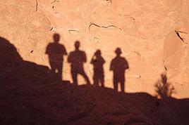
GPS Coordinates: 38.46934, -109.73947 Dead Horse Point Overlook
We decided to do a loop by hiking the West Rim Trail and the East Rim Trail. We parked our vehicle at the Dead Horse Point Overlook parking lot and first hiked the West Rim Trail to the Visitor Center (see video https://youtu.be/w0q4TFC3Q-E).
We took a lunch break and then hiked the East Rim Trail, which allowed us to return to Dead Horse Point while enjoying magnificent viewpoints along the way.
This hike covers a distance of 4.5 km, including the side trails that lead to additional viewpoints.
The East Rim Trail runs along the east side of the mesa summit and offers superb views of the canyon and the La Sal Mountains in the background.
** Basin Overlook
Apart from a small hill near the visitor center, the main trail is flat. However, the side trail leading to Basin Overlook is short but quite steep.
It offers excellent views of the canyon and the milky-blue ponds of a potash mine.
** Dead Horse Point Overlook
Dead Horse Point Overlook is reportedly one of the most photographed panoramic views in the world.
Over 600 meters above the winding Colorado River, this viewpoint offers vast, breathtaking views of a landscape filled with buttes and mesas, as well as the Colorado River snaking through the canyon.
https://youtu.be/sNHYiXKSuTo
USA 2022 Road Trip
by Pinacoladada
Translated into English.
Anne
Blogue: https://deuxnomades.blogspot.com/
YouTube: https://www.youtube.com/c/SouthAngelVideo?sub_confirmation=1
UTAH - MOAB - UTAH STATE ROUTE 279 (POTASH ROAD)
GPS coordinates: 38.6059, -109.6024 Start of the road
Utah State Route 279, also nicknamed Potash Road because it ends near the potash plant, is a scenic road located 6.6 kilometers north of the town of Moab in Utah.
The road follows the north bank of the Colorado River for 26 kilometers. From there, the road turns into a 4-wheel-drive track, the Shafer Trail, which passes by the milky-blue ponds of a potash mine.
This road allows us to discover several natural arches, rock paintings, and dinosaur tracks.
The high cliffs lining this road are also great for climbing.
In this video, you’ll travel the road with us and get the chance to see Jug Handle Arch as well as several petroglyphs.
Hiking trails also let us explore other natural arches, including Corona Arch, Bowtie Arch, and Pinto Arch, as well as dinosaur tracks.
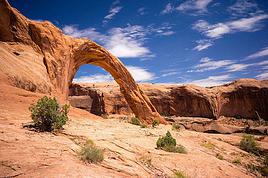
* Jug Handle Arch
GPS coordinates: 38.54658, -109.64820 Parking along the roadside GPS coordinates: 38.54853, -109.64801 Jug Handle Arch
Located at the foot of the old railway line, Jug Handle Arch is visible from the road.
There’s even an unmarked trail leading to two petroglyph panels near the arch. It’s still easy to follow since there are tracks from other hikers, though we didn’t take it.
* Petroglyphs
GPS coordinates: 38.54439, -109.60064
A large petroglyph panel is visible on a cliff along the road. Just park your vehicle by the roadside and look at the cliff on the opposite side.
This rock art is located about 7 meters up on the sandstone wall and stretches for around 38 meters. You can see figures, animals, and hunting scenes, among other things.
https://youtu.be/ZmJXIaqEVkU
GPS coordinates: 38.6059, -109.6024 Start of the road
Utah State Route 279, also nicknamed Potash Road because it ends near the potash plant, is a scenic road located 6.6 kilometers north of the town of Moab in Utah.
The road follows the north bank of the Colorado River for 26 kilometers. From there, the road turns into a 4-wheel-drive track, the Shafer Trail, which passes by the milky-blue ponds of a potash mine.
This road allows us to discover several natural arches, rock paintings, and dinosaur tracks.
The high cliffs lining this road are also great for climbing.
In this video, you’ll travel the road with us and get the chance to see Jug Handle Arch as well as several petroglyphs.
Hiking trails also let us explore other natural arches, including Corona Arch, Bowtie Arch, and Pinto Arch, as well as dinosaur tracks.
* Jug Handle Arch
GPS coordinates: 38.54658, -109.64820 Parking along the roadside GPS coordinates: 38.54853, -109.64801 Jug Handle Arch
Located at the foot of the old railway line, Jug Handle Arch is visible from the road.
There’s even an unmarked trail leading to two petroglyph panels near the arch. It’s still easy to follow since there are tracks from other hikers, though we didn’t take it.
* Petroglyphs
GPS coordinates: 38.54439, -109.60064
A large petroglyph panel is visible on a cliff along the road. Just park your vehicle by the roadside and look at the cliff on the opposite side.
This rock art is located about 7 meters up on the sandstone wall and stretches for around 38 meters. You can see figures, animals, and hunting scenes, among other things.
https://youtu.be/ZmJXIaqEVkU
Anne
Blogue: https://deuxnomades.blogspot.com/
YouTube: https://www.youtube.com/c/SouthAngelVideo?sub_confirmation=1
UTAH - MOAB - SHAFER TRAIL - POTASH EVAPORATION PONDS
GPS Coordinates: 38.52350, -109.65400 Start of Shafer Trail GPS Coordinates: 38.49049, -109.69284 Viewpoint
We first spotted these milky-blue ponds from viewpoints at Dead Horse Point State Park.
So we decided to get a closer look by taking Shafer Trail, which passes right by these ponds. Shafer Trail is a gravel road connecting Moab to Canyonlands National Park.
The road is well-maintained, but I’d say it’s best to drive a high-clearance vehicle since there are sometimes rocks or potholes in certain spots.
These blue ponds, called potash ponds or potash evaporation ponds, come into view after driving about +/- 8 km along Shafer Trail.
Texas Gulf built the plant back in the 1960s, but the system changed after an explosion trapped 25 miners, killing most of them. That’s when they switched to solution mining and solar evaporation, creating these famous ponds.
The potash mine is over 900 meters underground. Water from the Colorado River is first pumped in to create brine. Then, once the brine becomes highly concentrated, it’s pumped into the evaporation ponds.
After the water evaporates, the potash from each pond is harvested. Once collected, it’s used in fertilizers across the United States.
The potash ponds are blue because of a blue dye added to the brine. This dye helps speed up evaporation by increasing sunlight absorption. Darker water absorbs more sunlight and heat, allowing them to harvest the potash faster and restart the process.
The ponds aren’t always bright blue. The process takes about 300 days, and the ponds go through a variety of colors during that time. Shortly after adding the dye, you see the vivid blue. As evaporation progresses, the ponds turn light blue.
Eventually, the ponds become more brownish after most of the water has evaporated, leaving the potash at the bottom for collection.
https://youtu.be/4eDPxpE7E6M
Anne
Blogue: https://deuxnomades.blogspot.com/
YouTube: https://www.youtube.com/c/SouthAngelVideo?sub_confirmation=1
UTAH - MOAB - POTASH ROAD DINOSAUR TRACKS AND PETROGLYPHS
GPS coordinates: 38.53287, -109.60874 Parking and trailhead
A marked but steep trail zigzags along the cliffs and leads to a flat rock featuring dinosaur tracks. It’s about 200 meters to cover.
These are fossilized footprints dating back roughly 190 million years.
Continuing the hike northward and climbing to the base of the cliff, you’ll also find numerous petroglyphs depicting riders, animals, and other scenes from that distant era.
The trail is super short but can be challenging for those afraid of heights.
https://youtu.be/PSvVBrz57Fc
Anne
Blogue: https://deuxnomades.blogspot.com/
YouTube: https://www.youtube.com/c/SouthAngelVideo?sub_confirmation=1
UTAH - MOAB - POTASH ROAD - CORONA, BOWTIE & PINTO ARCHES TRAIL
GPS coordinates: 38.57444, -109.63241 Parking and trailhead GPS coordinates: 38.58076, -109.62168 Bowtie Arch GPS coordinates: 38.58076, -109.62168 Corona Arch GPS coordinates: 38.58165, -109.62750 Pinto Arch
This amazing 3.9 km (2.4 mi) round-trip hike leads to two arches, including Corona Arch, which is one of the largest arches in the Moab area.
Corona Arch, also called Little Rainbow Bridge, is the final destination, but the trail also passes by Pinto Arch and Bowtie Arch along the way.
The trail starts on the right side of the parking lot. It quickly climbs a rocky slope and reaches a railroad track that you’ll need to cross. You’ll also find various wildflowers along the trail.
The sandy trail then follows an old road along a cliff. You can even spot Pinto Arch in the distance on the other side of the canyon, accessible via a side trail that branches off from the main path—adding extra distance if you choose to go there.
Pinto Arch is a great example of a pothole arch, formed over time by water and erosion.
Continuing toward Corona Arch, the trail crosses wide expanses of rock walls. These sections, however, are well-marked with cairns.
Some rock walls also have metal cables to use as handrails, and you’ll need to climb a short ladder to reach a higher level.
Already, you get an excellent view of Bowtie Arch and Corona Arch overlooking Bootlegger Canyon.
We walk along the rock walls and quickly reach Bowtie Arch, which formed when a pothole above—usually filled with water—eroded into a cave below. This arch is stunning.
We finished our hike at Corona Arch, located near Bowtie Arch. This arch, standing 33.5 meters (110 ft) tall and 42 meters (138 ft) wide, is truly spectacular and set in a magical landscape.
This trail is out-and-back, so you’ll retrace your steps to return to the parking lot.
https://youtu.be/h1gPpCj4tmQ
Anne
Blogue: https://deuxnomades.blogspot.com/
YouTube: https://www.youtube.com/c/SouthAngelVideo?sub_confirmation=1
UTAH - MOAB - POTASH ROAD - WALL STREET CLIMBING AREA
GPS coordinates: 38.54994, -109.59724
Potash Road is one of Moab, Utah’s top climbing destinations. Over a hundred routes exist in the Wall Street area alone, with dozens more on other roadside rocks and in side canyons. Plus, it’s free.
Easy to access since the climbing is done on cliffs right along the road. You can even watch climbers from the roadside shoulder.
https://youtu.be/SPjB4Ak18tE
Anne
Blogue: https://deuxnomades.blogspot.com/
YouTube: https://www.youtube.com/c/SouthAngelVideo?sub_confirmation=1
UTAH - MOAB - KANE SPRINGS ROAD
GPS coordinates: 38.5637, -109.5502 Start of this road
Kane Creek Boulevard starts in the town of Moab and becomes Kane Springs Road after traveling about 7.5 kilometers on this road. It follows the east side of the Colorado River.
The first half of this narrow road is paved, while the second half is a well-maintained dirt road that’s incredibly scenic.
The canyon this road winds through is truly majestic. The rock formations are breathtaking.
We also discovered a site along this road called the "Birthing Scene Petroglyph Panel," which is actually a historic rock art site left by the Indigenous people who once lived in this region.
https://youtu.be/uJ9VdYYSH_U
Anne
Blogue: https://deuxnomades.blogspot.com/
YouTube: https://www.youtube.com/c/SouthAngelVideo?sub_confirmation=1
UTAH - MOAB - KANE SPRINGS ROAD - SIDE BY SIDE ADVENTURE
When we were driving along this dirt road, we came across some side-by-side vehicles that were probably returning from a trip to Hurrah Pass.
I had fun filming them as they had to cross deep puddles that had formed on the road.
As they passed close by me, some even tried to splash me, but no luck!
https://youtu.be/_FHMSLblk1w
Anne
Blogue: https://deuxnomades.blogspot.com/
YouTube: https://www.youtube.com/c/SouthAngelVideo?sub_confirmation=1
UTAH - MOAB - KANE SPRINGS ROAD TOWARD MOAB
We're heading back on Kane Springs Road toward Moab, and it lets us admire the scenery from a different angle—one that’s actually really picturesque. The towering cliffs in front of us are absolutely breathtaking.
https://youtu.be/4vvdVDEulzc
We're heading back on Kane Springs Road toward Moab, and it lets us admire the scenery from a different angle—one that’s actually really picturesque. The towering cliffs in front of us are absolutely breathtaking.
https://youtu.be/4vvdVDEulzc
Anne
Blogue: https://deuxnomades.blogspot.com/
YouTube: https://www.youtube.com/c/SouthAngelVideo?sub_confirmation=1
UTAH - CANYONLANDS NATIONAL PARK - ISLAND IN THE SKY - MESA ARCH TRAIL
GPS coordinates: 38.38920, -109.86811 Parking GPS coordinates: 38.38804, -109.86349 Mesa Arch
Mesa Arch Trail is an easy 0.7-mile loop hike that leads to a beautiful arch overlooking Buck Canyon.
In the background, you can also see the La Sal Mountains, whose peaks are still snow-capped.
The trail is well-marked and partly runs over smooth slickrock formations.
The arch is located halfway along the trail, and there are no barriers around it. Be cautious, as a fall here would be fatal.
https://youtu.be/H0WbNoav3xA
Anne
Blogue: https://deuxnomades.blogspot.com/
YouTube: https://www.youtube.com/c/SouthAngelVideo?sub_confirmation=1
UTAH - CANYONLANDS NATIONAL PARK - ISLAND IN THE SKY - AZTEC BUTTE TRAIL
GPS coordinates: 38.39347, -109.88205 Parking lot and trailhead GPS coordinates: 38.39563, -109.87779 Junction for the granary GPS coordinates: 38.39529, -109.87987 Granary GPS coordinates: 38.39730, -109.87471 Aztec Butte
This moderate 1.7-mile (2.7 km) round-trip trail first follows a sandy wash before splitting into two sections.
The left trail climbs to the top of a butte. Just follow the cairns placed on the slickrock to reach an ancient Anasazi granary, where you’ll enjoy a stunning view of Taylor Canyon.
We then return to the previously mentioned junction and continue on the main trail leading to the base of Aztec Butte.
The trail to the top of Aztec Butte runs across slickrock, with cairns marking the way.
Just before reaching the summit, this section of the trail is very steep and climbs along the edges. Keep this in mind if you're afraid of heights.
The trail loops around the top of the butte, offering fantastic views of the canyon, the many rock formations, and the La Sal Mountains.
We then retrace our steps back to the parking lot.
https://youtu.be/mVcU4VLAfBY
Anne
Blogue: https://deuxnomades.blogspot.com/
YouTube: https://www.youtube.com/c/SouthAngelVideo?sub_confirmation=1
UTAH - CANYONLANDS NATIONAL PARK - ISLAND IN THE SKY - WHALE ROCK TRAIL
GPS coordinates: 38.42677, -109.91400 Trailhead and parking GPS coordinates: 38.42831, -109.91695 End of the trail
This 0.8-mile round-trip trail climbs along a sandstone dome and ends with a 360° view of Island in the Sky.
The dome looks like a massive beached whale. At the top, the views of the park are absolutely breathtaking.
This trail is rated as moderate by the National Park Service, while other sites list it as easy.
Actually, the trail is rugged and requires climbing up and down a rocky hill and stone steps. Good hiking shoes are essential for the ascent and descent on the slickrock.
https://youtu.be/idfKXmZgrVM
Anne
Blogue: https://deuxnomades.blogspot.com/
YouTube: https://www.youtube.com/c/SouthAngelVideo?sub_confirmation=1
UTAH - CANYONLANDS NATIONAL PARK - ISLAND IN THE SKY - UPHEAVAL DOME TRAIL
GPS coordinates: 38.42631, -109.92609 Parking and trailhead GPS coordinates: 38.42900, -109.92920 Viewpoint 1 GPS coordinates: 38.42972, -109.93376 Viewpoint 2 and end of trail
The Upheaval Dome Trail is a moderate 2 km (1.2 mi) round-trip hike that offers great viewpoints of a crater-like geological formation with an inner diameter of about 5 km and over 300 meters deep.
The trail is short but steep. The beginning is well-marked with several stone steps, quickly leading to the first viewpoint less than 500 meters from the parking lot.
Already at this spot, you get an amazing view of this strange formation.
You’ll need to hike an additional 500 meters to reach the second viewpoint, which offers a different angle of the crater.
This section of the trail is more challenging than the first, partly traversing slickrock. Cairns are set up to guide the way.
The final stretch also includes some steep climbs and descents.
Two theories exist about this truly unique geological formation.
The first suggests Upheaval Dome was formed by a salt dome created from the evaporation of ancient inland seas.
The second theory proposes that the crater was formed by a meteorite impact around 60 million years ago, as the rocks show signs of extreme pressure only possible from a high-impact event.
Recent research supports the meteorite hypothesis, but questions remain. Over time, scientists may unravel the mystery of this crater.
https://youtu.be/las6uxMoUnA
Anne
Blogue: https://deuxnomades.blogspot.com/
YouTube: https://www.youtube.com/c/SouthAngelVideo?sub_confirmation=1
UTAH - CANYONLANDS NATIONAL PARK - ISLAND IN THE SKY - GRAND VIEW POINT OVERLOOK TRAIL
GPS Coordinates: 38.31077, -109.85657 Trailhead GPS Coordinates: 38.31019, -109.85672 Overlook 1 GPS Coordinates: 38.30333, -109.86781 Overlook 2
The Grand View Point Overlook Trail is a 3-kilometer (round-trip) trail that offers stunning views of a complex network of canyons carved by the convergence of the Colorado River and the Green River.
A short paved sidewalk leads to a spectacular viewpoint. Informational panels illustrate the geological layers that make up Canyonlands National Park.
The Colorado River has carved a trench over 300 meters deep into the earth. The next layer is the White Rim. This feature runs along the tops of the canyons, its coloration coming from salt deposits in the soil. And then, 300 meters above the rim, is the top of the mesa, where we are now.
From there, you can walk an additional kilometer to reach a second overlook. Just follow the cairns that mark the way.
This part of the trail is easy to walk. However, it includes several steps to climb up and down.
The second overlook offers beautiful views of Monument Basin, Junction Butte, and two other regions of Canyonlands National Park: Needles and Maze.
https://youtu.be/8cwcOpRJhE0
Anne
Blogue: https://deuxnomades.blogspot.com/
YouTube: https://www.youtube.com/c/SouthAngelVideo?sub_confirmation=1
UTAH - CANYONLANDS NATIONAL PARK - ISLAND IN THE SKY - WHITE RIM OVERLOOK TRAIL
GPS Coordinates: 38.32277, -109.84951 Parking and trailhead GPS Coordinates: 38.31995, -109.83524 End of trail
The Island in the Sky district of Canyonlands National Park is famous for its high-elevation views of massive canyons. One of the best east-facing views is definitely White Rim Overlook.
White Rim Overlook is located near Grand View Point, but it offers a different perspective on the Colorado River, Monument Basin, and the La Sal Mountains.
This easy 1.8-mile round-trip trail leads to a narrow, high mesa with one of the most stunning panoramic views in the entire park.
It allows us to see, among other things, a vast expanse of canyons shaped by the Colorado River. The tops of these canyons are covered with a thick layer of white rock.
Monument Basin is a great example of this type of canyon. Many hoodoos still rise today in this beautiful canyon.
https://youtu.be/2YwE8vkZR5Y
Anne
Blogue: https://deuxnomades.blogspot.com/
YouTube: https://www.youtube.com/c/SouthAngelVideo?sub_confirmation=1
UTAH - CANYONLANDS NATIONAL PARK - ISLAND IN THE SKY - OVERLOOKS
Island in the Sky, located in Canyonlands National Park in Utah, is a wide, flat mesa perched atop steep sandstone cliffs that rise over 300 meters above the surrounding terrain.
Each viewpoint offers a different perspective on the stunning landscape of this magnificent park.
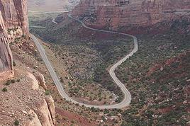
Shafer Canyon Overlooks 38.45982, -109.81996 Overlook 1 38.45270, -109.81811 Overlook 2
These two overlooks are built on the edge of the mesa and allow us to admire Shafer Canyon. The Shafer Trail, a winding road, descends into this canyon 426 meters below.
The Neck 38.45109, -109.82076
You can see the road crossing a narrow strip of land known as "The Neck." This small stone bridge is all that connects Island in the Sky to the rest of the land.
Shafer Trail Viewpoint 38.44825, -109.82151
This overlook offers a superb view of the Shafer Trail winding down the sheer cliff walls into the canyon below.
Mesa Arch Overlook 38.38920, -109.86811 Parking 38.38804, -109.86349 Mesa Arch
Mesa Arch Trail features a very pretty arch overlooking Buck Canyon. However, you’ll need to take an easy 1.1 km loop hike to see it.
Green River Overlook 38.37931, -109.88805 Parking 38.37833, -109.88833 Overlook
The Green River Overlook is a viewpoint where you can see the Green River meandering through the vast Soda Springs Basin.
Aztec Butte Trail 38.39347, -109.88205 Trailhead 38.39529, -109.87987 Granary 38.39730, -109.87471 Aztec Butte
This moderate 2.7 km round-trip trail lets you discover an ancient Anasazi granary, offering a breathtaking view of Taylor Canyon and Aztec Butte. At the top, a loop trail provides stunning viewpoints of the canyon, numerous rock formations, and the La Sal Mountains.
Holeman Spring Canyon Overlook 38.41211, -109.90469
A roughly 800-meter round-trip trail leads to a fantastic viewpoint over the canyon. You’ll need to park your vehicle along the road to start this hike.
Alcove Spring 38.42309, -109.90878 Trailhead 38.42372, -109.90742 Viewpoint
We only hiked about a hundred meters on this challenging 18 km trail to get a nice viewpoint over the canyon.
Whale Rock Overlook 38.42677, -109.91400 Trailhead 38.42831, -109.91695 End of trail
This overlook is only accessible via a 1.3 km round-trip hiking trail that climbs a sandstone dome, offering a 360° view of Island in the Sky.
Upheaval Dome Overlooks 38.42631, -109.92609 Trailhead 38.42900, -109.92920 Viewpoint 1 38.42972, -109.93376 Viewpoint 2 and end of trail
Upheaval Dome Trail is a moderate 2 km round-trip trail that offers lovely viewpoints of a crater-like geological formation with an inner diameter of about 5 km and over 300 meters deep.
Candlestick Tower Overlook 38.37444, -109.86848
This overlook provides a magnificent view of the park, particularly of a rock formation called Candlestick Tower, a 140-meter-high sandstone butte.
Buck Canyon Overlook 38.34580, -109.86097 Parking 38.34596, -109.86021 Overlook
It’s just a 140-meter round-trip walk to enjoy a breathtaking view of the canyon with the La Sal Mountains in the distance.
White Rim Overlook 38.32277, -109.84951 Trailhead 38.31995, -109.83524 Overlook
One of the best east-facing views is definitely White Rim Overlook. This viewpoint is accessible via an easy 2.9 km round-trip trail that offers a sensational panoramic view of the Colorado River, Monument Basin, and the La Sal Mountains.
Orange Cliffs Overlook 38.31365, -109.85700
This overlook offers a panoramic view of the Green River Canyon. You can see the sandstone cliffs called Orange Cliffs, located in Glen Canyon, as well as the Maze district of Canyonlands stretching to the south.
Grand View Point Overlook Trail 38.31077, -109.85657 Trailhead 38.31019, -109.85672 Overlook 1 38.30333, -109.86781 Overlook 2
Grand View Point Overlook Trail is a 3 km round-trip trail that offers viewpoints of a complex network of canyons carved by the convergence of the Colorado River and the Green River.
https://youtu.be/kr34xq2dvS4
Island in the Sky, located in Canyonlands National Park in Utah, is a wide, flat mesa perched atop steep sandstone cliffs that rise over 300 meters above the surrounding terrain.
Each viewpoint offers a different perspective on the stunning landscape of this magnificent park.
Shafer Canyon Overlooks 38.45982, -109.81996 Overlook 1 38.45270, -109.81811 Overlook 2
These two overlooks are built on the edge of the mesa and allow us to admire Shafer Canyon. The Shafer Trail, a winding road, descends into this canyon 426 meters below.
The Neck 38.45109, -109.82076
You can see the road crossing a narrow strip of land known as "The Neck." This small stone bridge is all that connects Island in the Sky to the rest of the land.
Shafer Trail Viewpoint 38.44825, -109.82151
This overlook offers a superb view of the Shafer Trail winding down the sheer cliff walls into the canyon below.
Mesa Arch Overlook 38.38920, -109.86811 Parking 38.38804, -109.86349 Mesa Arch
Mesa Arch Trail features a very pretty arch overlooking Buck Canyon. However, you’ll need to take an easy 1.1 km loop hike to see it.
Green River Overlook 38.37931, -109.88805 Parking 38.37833, -109.88833 Overlook
The Green River Overlook is a viewpoint where you can see the Green River meandering through the vast Soda Springs Basin.
Aztec Butte Trail 38.39347, -109.88205 Trailhead 38.39529, -109.87987 Granary 38.39730, -109.87471 Aztec Butte
This moderate 2.7 km round-trip trail lets you discover an ancient Anasazi granary, offering a breathtaking view of Taylor Canyon and Aztec Butte. At the top, a loop trail provides stunning viewpoints of the canyon, numerous rock formations, and the La Sal Mountains.
Holeman Spring Canyon Overlook 38.41211, -109.90469
A roughly 800-meter round-trip trail leads to a fantastic viewpoint over the canyon. You’ll need to park your vehicle along the road to start this hike.
Alcove Spring 38.42309, -109.90878 Trailhead 38.42372, -109.90742 Viewpoint
We only hiked about a hundred meters on this challenging 18 km trail to get a nice viewpoint over the canyon.
Whale Rock Overlook 38.42677, -109.91400 Trailhead 38.42831, -109.91695 End of trail
This overlook is only accessible via a 1.3 km round-trip hiking trail that climbs a sandstone dome, offering a 360° view of Island in the Sky.
Upheaval Dome Overlooks 38.42631, -109.92609 Trailhead 38.42900, -109.92920 Viewpoint 1 38.42972, -109.93376 Viewpoint 2 and end of trail
Upheaval Dome Trail is a moderate 2 km round-trip trail that offers lovely viewpoints of a crater-like geological formation with an inner diameter of about 5 km and over 300 meters deep.
Candlestick Tower Overlook 38.37444, -109.86848
This overlook provides a magnificent view of the park, particularly of a rock formation called Candlestick Tower, a 140-meter-high sandstone butte.
Buck Canyon Overlook 38.34580, -109.86097 Parking 38.34596, -109.86021 Overlook
It’s just a 140-meter round-trip walk to enjoy a breathtaking view of the canyon with the La Sal Mountains in the distance.
White Rim Overlook 38.32277, -109.84951 Trailhead 38.31995, -109.83524 Overlook
One of the best east-facing views is definitely White Rim Overlook. This viewpoint is accessible via an easy 2.9 km round-trip trail that offers a sensational panoramic view of the Colorado River, Monument Basin, and the La Sal Mountains.
Orange Cliffs Overlook 38.31365, -109.85700
This overlook offers a panoramic view of the Green River Canyon. You can see the sandstone cliffs called Orange Cliffs, located in Glen Canyon, as well as the Maze district of Canyonlands stretching to the south.
Grand View Point Overlook Trail 38.31077, -109.85657 Trailhead 38.31019, -109.85672 Overlook 1 38.30333, -109.86781 Overlook 2
Grand View Point Overlook Trail is a 3 km round-trip trail that offers viewpoints of a complex network of canyons carved by the convergence of the Colorado River and the Green River.
https://youtu.be/kr34xq2dvS4
Anne
Blogue: https://deuxnomades.blogspot.com/
YouTube: https://www.youtube.com/c/SouthAngelVideo?sub_confirmation=1
UTAH - MOAB - WILSON ARCH
GPS coordinates: 38.27348, -109.37254 Parking GPS coordinates: 38.27269, -109.37125 Arch
Wilson Arch is a natural sandstone arch located along US 191, about forty kilometers south of Moab. It's visible from the road and has a parking area where you can stop.
It’s named after Joe Wilson, a pioneer from Dry Valley.
The trail to get there is short (less than a kilometer round trip). However, the slope to get under the arch is quite steep, and the ground can be slippery in some spots.
Sitting under the arch, we enjoyed the panoramic view of the surrounding landscape, which is really picturesque.
If you don’t have the time or ability to go under the arch, the view from the parking area is still absolutely spectacular.
https://youtu.be/o9qD5m4Bm4c
Anne
Blogue: https://deuxnomades.blogspot.com/
YouTube: https://www.youtube.com/c/SouthAngelVideo?sub_confirmation=1
UTAH - MONTICELLO - NEWSPAPER ROCK STATE HISTORICAL MONUMENT
GPS coordinates: 37.98822, -109.51812
Newspaper Rock is a petroglyph site located in Monticello, Utah. Over 650 rock art drawings are displayed on a 19-square-meter rock panel.
These drawings depict human figures, animals, and various symbols, some of which are considered to be of a religious nature.
The first petroglyphs at this site were created about 2,000 years ago by Native Americans.
In Navajo, this rock is called "Tse' Hone'", which means it's a rock that tells a story.
https://youtu.be/_2JN-GAXckk
Anne
Blogue: https://deuxnomades.blogspot.com/
YouTube: https://www.youtube.com/c/SouthAngelVideo?sub_confirmation=1
UTAH - CANYONLANDS NATIONAL PARK - THE NEEDLES - ROAD SIDE RUIN TRAIL
GPS coordinates: 38.16314, -109.76265 Parking GPS coordinates: 38.16374, -109.76038 Ancient granary
This very short hike (loop of about 450 m) leads to the vicinity of an ancient Anasazi granary.
Located between two ledges of a cliff, it appears to be one of the best-preserved in the park.
https://youtu.be/60SC5jopXNU
Anne
Blogue: https://deuxnomades.blogspot.com/
YouTube: https://www.youtube.com/c/SouthAngelVideo?sub_confirmation=1
UTAH - CANYONLANDS NATIONAL PARK - THE NEEDLES - CAVE SPRING TRAIL
GPS coordinates: 38.15722, -109.75154 Parking GPS coordinates: 38.15693, -109.75226 Cowboy camp ruins GPS coordinates: 38.15673, -109.75342 Cave - Rock art GPS coordinates: 38.15668, -109.75371 Spring
Cave Spring Trail is a 0.6-mile loop trail that lets you discover the ruins of a cowboy camp, a year-round spring, and prehistoric rock art.
The main attractions are located at the beginning of this easy-to-walk trail, so you can turn back afterward if you'd like.
If you want to complete the full loop, note that you’ll need to climb two ladders anchored in the rocks to reach higher levels.
https://youtu.be/oiH_vb-EES0
Anne
Blogue: https://deuxnomades.blogspot.com/
YouTube: https://www.youtube.com/c/SouthAngelVideo?sub_confirmation=1
UTAH - CANYONLANDS NATIONAL PARK - THE NEEDLES - POTHOLE POINT TRAIL
GPS coordinates: 38.17029, -109.80638 Parking lot and trailhead GPS coordinates: 38.17055, -109.80893 Left junction GPS coordinates: 38.16987, -109.80956 Viewpoint GPS coordinates: 38.17168, -109.80877 Intersection 1 GPS coordinates: 38.17226, -109.80826 Intersection 2
This 1 km loop hike gets its name from the depressions in the rocks called potholes. Rainwater collects in these depressions, creating an ideal habitat for creatures like snails, worms, and shrimp to hatch.
Over time, potholes can grow large enough to collect enough dust to allow plants to take root.
When we were there, the potholes didn’t have any water.
We did this hike clockwise, but the loop can be done in either direction. Cairns on the slickrock mark the trail.
First, we headed to a viewpoint that offers a distant view of Chesler Park. This area features the Needles—stunning rock formations like spires, pinnacles, and monoliths.
We continued our hike, admiring the massive rock formations along the trail, their shapes sparking our imagination.
Along the way, we passed two intersections. No matter which direction you take, the trail will lead you back to the parking lot as long as you follow the cairns on the ground.
https://youtu.be/4UjkQJXCWek
Anne
Blogue: https://deuxnomades.blogspot.com/
YouTube: https://www.youtube.com/c/SouthAngelVideo?sub_confirmation=1
UTAH - CANYONLANDS NATIONAL PARK - THE NEEDLES - BIG SPRING CANYON OVERLOOK TRAIL
GPS coordinates: 38.17821, -109.81717 Trailhead GPS coordinates: 38.17869, -109.81836 Overlook 1 GPS coordinates: 38.17935, -109.81892 Overlook 2
Big Spring Overlook is located at the end of the main road that runs through The Needles, a district of Canyonlands National Park.
A short 400-meter round-trip hike takes you to two overlooks that offer stunning views of the canyon and the colorful rock formations, which are truly breathtaking.
Big Spring is located in the canyon below. The water allows trees and plants to thrive in spring and summer.
https://youtu.be/ljqwRKCaMk0
Anne
Blogue: https://deuxnomades.blogspot.com/
YouTube: https://www.youtube.com/c/SouthAngelVideo?sub_confirmation=1
UTAH - CANYONLANDS NATIONAL PARK - THE NEEDLES - OVERLOOKS
** Roadside Ruin Trail **
GPS Coordinates: 38.16314, -109.76265 Parking GPS Coordinates: 38.16374, -109.76038 Ancient granary
A short hike that leads to an ancient Anasazi granary.
** Cave Spring Trail **
GPS Coordinates: 38.15722, -109.75154 Parking GPS Coordinates: 38.15693, -109.75226 Cowboy camp ruins GPS Coordinates: 38.15673, -109.75342 Cave - Rock paintings GPS Coordinates: 38.15668, -109.75371 Spring
Cave Spring Trail is a 0.6-mile loop that lets you discover the ruins of a cowboy camp, a year-round spring, and prehistoric rock paintings.
** Wooden Shoe Arch Overlook **
GPS Coordinates: 38.15049, -109.78147 Overlook GPS Coordinates: 38.13999, -109.77650 Wooden Shoe Arch
This overlook offers a distant view of a rock formation that looks like a wooden shoe.
** Squaw Flat Overlook **
GPS Coordinates: 38.14358, -109.80352
Squaw Flat is an amazing spot with rocks that resemble mushrooms. It also provides a stunning viewpoint of the rock formations called The Needles in Chesler Park.
In this area, there’s a campground where many hikes start.
** Pothole Point Trail **
GPS Coordinates: 38.17029, -109.80638 Parking and trailhead GPS Coordinates: 38.17055, -109.80893 Left junction GPS Coordinates: 38.16987, -109.80956 Viewpoint GPS Coordinates: 38.17168, -109.80877 Intersection 1 GPS Coordinates: 38.17226, -109.80826 Intersection 2
A 0.6-mile loop trail marked by cairns that leads to potholes. When water collects in these depressions, they create an ideal habitat for snails, worms, and shrimp to hatch. The trail also offers a distant view of the hoodoos in Chesler Park.
** Big Spring Canyon Overlook **
GPS Coordinates: 38.17821, -109.81717 Trailhead GPS Coordinates: 38.17869, -109.81836 Overlook 1 GPS Coordinates: 38.17935, -109.81892 Overlook 2
Big Spring Overlook features two overlooks with breathtaking views of the canyon and the stunning multicolored rock formations.
https://youtu.be/n1bDvUhUWpI
Anne
Blogue: https://deuxnomades.blogspot.com/
YouTube: https://www.youtube.com/c/SouthAngelVideo?sub_confirmation=1
COLORADO - MESA VERDE NATIONAL PARK - MESA TOP RUINS ROAD
GPS Coordinates: 37.33578, -108.40788 Visitor Center
This park, located in southwestern Colorado, is a UNESCO World Heritage Site. It houses the best-preserved cliff dwellings in the United States.
Nearly 600 cliff dwellings have been recorded in Mesa Verde National Park. The most famous include Cliff Palace and Spruce House, which contain over 100 rooms and numerous kivas.
A scenic road runs through the park. After 25 kilometers, it splits into two. Wetherill Mesa Road leads to Step House and Long House, while Chapin Mesa Road leads to Spruce Tree House, Cliff Palace, and Balcony House.
Chapin Mesa Road also splits into two small loops.
Four cliff dwellings are open to the public and can be explored, including Cliff Palace, Balcony House, Long House, and Step House.
Since 2015, Spruce Tree House has been closed to visitors due to a risk of rockfall. However, the park is working on a stabilization project so the site can reopen.
* Mesa Top Ruins Road
** Mancos Valley Overlook
GPS Coordinates: 37.30435, -108.41049
Mancos Valley Overlook is the first stop on the main road after entering Mesa Verde National Park. This viewpoint offers a stunning view of the Mancos Valley and the snow-capped La Plata Mountains.
** Montezuma Valley Overlook
GPS Coordinates: 37.29642, -108.44171
This overlook provides a superb view of the entire Montezuma Valley.
** Park Point Overlook
GPS Coordinates: 37.27930, -108.46176
Park Point Overlook is a cool and windy spot located 2,612 meters above sea level. It’s the highest point in the park.
There are two viewpoints here offering different vistas of the San Juan Mountains, the high deserts of New Mexico, Sleeping Ute Mountain, and the La Plata Mountains.
** Geologic Overlook
GPS Coordinates: 37.27632, -108.48305
Geologic Overlook is a short paved trail where you can observe the different layers of shale and sandstone in the cliffs.
** Far View Area
GPS Coordinates: 37.23783, -108.50399 Parking GPS Coordinates: 37.23788, -108.50370 Far View House GPS Coordinates: 37.23742, -108.50348 Pipe Shrine House GPS Coordinates: 37.23693, -108.50594 Coyote Village GPS Coordinates: 37.23685, -108.50586 Far View Reservoir GPS Coordinates: 37.24181, -108.50418 Megalithic House GPS Coordinates: 37.23902, -108.50424 Far View Tower
A 1.2 km loop trail lets you explore Far View, which was one of the most densely populated areas on the mesa from around 900 to 1300 AD.
Nearly 50 villages have been identified in less than one square kilometer. These housed hundreds of people.
This area was once a vast agricultural community and one of the most densely populated regions of Mesa Verde.
Far View House, Pipe Shrine House, Coyote Village, Far View Reservoir (currently dry), Megalithic House, and Far View Tower were all part of this community.
In ancient times, it was a place of modest homes interspersed with small farm fields. It was a spot filled with people, vibrant life, and constant change.
Archaeological evidence at Far View reveals thriving communities on top of the mesa long before the famous cliff dwellings existed. But it also reveals another little-known fact: not everyone eventually moved into the cliff dwellings.
Some families clearly chose to stay on top of the mesa, like those at Far View, long after many of their neighbors had settled into cliff alcoves.
As you follow the wooded trail leading to the six sites, it’s fascinating to read the signs that teach us more about the ancestral Pueblo way of life.
https://youtu.be/9Lr48tB2bp0
Anne
Blogue: https://deuxnomades.blogspot.com/
YouTube: https://www.youtube.com/c/SouthAngelVideo?sub_confirmation=1
COLORADO - MESA VERDE NATIONAL PARK - CHAPIN MESA ROAD
* Cedar Tree Tower
GPS Coordinates: 37.19848, -108.48242
Cedar Tree Tower is one of many sites discovered on the mesa’s summits. These sites, including Cedar Tree Tower, were primarily built during the Classic Period (1100–1300 AD). They’re usually associated with a kiva.
The purpose of a tower-kiva complex isn’t fully understood. Some believe the towers had a ceremonial purpose due to their close association with kivas. Others suggest the mesa-top towers were part of a communication system.
* Spruce Tree House
GPS Coordinates: 37.18417, -108.48911
Spruce Tree House is one of the park’s largest and best-preserved cliff dwellings.
This dwelling was built between 1211 and 1278 by the ancestors of the Pueblo peoples of the Southwest.
It includes 130 rooms and 8 kivas spread over 66 meters long and 27 meters deep under the cliff alcove. It’s thought to have housed around 60 to 80 people.
Since 2015, Spruce Tree House has been closed to visitors due to a rockfall risk. However, the park is working on a stabilization project so the site can reopen.
Still, you can view Spruce Tree House from the overlook behind the Chapin Mesa Museum.
https://youtu.be/do2ANh300WA
Anne
Blogue: https://deuxnomades.blogspot.com/
YouTube: https://www.youtube.com/c/SouthAngelVideo?sub_confirmation=1
COLORADO - MESA VERDE NATIONAL PARK - MESA TOP LOOP
** Navajo Canyon Overlook
GPS coordinates: 37.16688, -108.49288 Photo stop
This overlook, located at an elevation of 2,130 meters, offers a spectacular backdrop of Navajo Canyon.
The mesa is home to over 1,000 species of plants and animals. These species once provided food, tools, clothing, and medicine for the ancestral Pueblo people.
** Square Tower House Overlook
GPS coordinates: 37.16668, -108.49135 Parking and trailhead GPS coordinates: 37.16572, -108.49159 Overlook GPS coordinates: 37.16594, -108.49134 Square Tower House
A short trail leads to a viewpoint of this cliff dwelling. Square Tower House was inhabited between 1200 and 1300 A.D.
It gets its name from the unusual four-story tower that stands against the curved back wall of the alcove. Some interior walls of the tower were plastered. A spring beneath the alcove provided water for the inhabitants.
** Sun Point View
GPS coordinates: 37.16184, -108.47495
This overlook offers a panoramic view of Fewkes and Cliff Canyons, where the following dwellings were built: Sun Temple, Mummy House, Oak Tree House, Fire Temple, and Cliff Palace.
** Oak Tree House Overlook
GPS coordinates: 37.16330, -108.47690 Overlook GPS coordinates: 37.16463, -108.47736 Oak Tree House
This 60-room site, built on two ledges, is one of the largest cliff dwellings in the park. It’s a well-preserved but fragile site, featuring plastered walls and varied architectural styles.
** Fire Temple Overlook
GPS coordinates: 37.16469, -108.47923 Overlook GPS coordinates: 37.16543, -108.47926 Fire Temple
This overlook shows how the builders used natural layers in the sandstone to construct this two-level dwelling and ceremonial center.
The holes visible on the cliff ledge between the two ruins indicate that a ladder once connected the two levels.
** Sun Temple
GPS coordinates: 37.16510, -108.47576 Trailhead GPS coordinates: 37.16472, -108.47556 Sun Temple GPS coordinates: 37.16522, -108.47551 Cliff Palace Overlook
Sun Temple is the last stop on Mesa Top Loop Road. A 200-meter loop trail leads to Sun Temple, a ceremonial structure, as well as an overlook offering a stunning view of Cliff Palace.
Recent studies reveal that Cliff Palace contained 150 rooms and 21 kivas and had a population of about 100 people.
https://youtu.be/xDTGNn8zcsM
Anne
Blogue: https://deuxnomades.blogspot.com/
YouTube: https://www.youtube.com/c/SouthAngelVideo?sub_confirmation=1
COLORADO - MESA VERDE NATIONAL PARK - WETHERILL MESA ROAD
** Fire Recovery Viewpoint
GPS coordinates: 37.26479, -108.54972 Overlook
This overlook helps us understand how fires affect the landscape.
Often, a dry lightning strike will ignite a lone tree. The fire can smolder and go undetected for several days until hot, dry, and windy conditions cause it to spread rapidly. Under the right conditions, a wind-driven fire can char thousands of acres in just a few hours.
Sometimes, a fire burns in an area that was previously burned. When this happens, the fire’s intensity decreases. These burned areas act as fuel breaks. The patchwork of burned and recovering zones creates a natural mosaic of grasses, flowers, mountain shrubs, and a forest of mature pines and junipers. It takes centuries for a pine and juniper forest to fully recover from a fire.
** Rock Canyon Tower View Trail
GPS coordinates: 37.22824, -108.55083 Overlook
Distant view of Rock Canyon.
** Step House Trail
GPS coordinates: 37.19597, -108.53740 Trailhead GPS coordinates: 37.19720, -108.53617 Step House
A 0.9-mile loop hike starting near the Wetherill Mesa kiosk. The trail is steep and involves a descent and ascent on a winding path.
This trail lets you explore Step House, which includes a basketmaker site dating back to 626 AD and a Pueblo masonry site from 1226 AD.
A ranger is on-site to answer visitors’ questions.
Step House is a free, self-guided cliff dwelling. Open from spring to fall; please check the opening hours.
** Long House
GPS coordinates: 37.19581, -108.53734
Long House is considered the second-largest dwelling village in the park. Up to 150 people lived there. The 150 rooms are not clustered like standard cliff dwellings. Two overhead ledges contain several rooms.
To visit, you’ll need to climb several ladders. Not recommended for those prone to vertigo.
The tour is led by a ranger, and you must pay the associated fees at the Visitor Center.
Unfortunately, we didn’t get to visit it because no spots were available on the day we were there.
* Cliff Palace Loop
During our visit, this road was closed due to ongoing construction work.
https://youtu.be/IfPgBpxuDoI
Anne
Blogue: https://deuxnomades.blogspot.com/
YouTube: https://www.youtube.com/c/SouthAngelVideo?sub_confirmation=1
COLORADO - GREAT SAND DUNES NATIONAL PARK
GPS Coordinates: 37.73298, -105.51226 Visitor Center GPS Coordinates: 37.73950, -105.51710 Parking near the dunes
Great Sand Dunes National Park is located in southern Colorado. It contains the tallest sand dunes in North America, spanning nearly 78 km².
The landscape is stunning: sand dunes on one side and snow-capped peaks on the other.
There are no trails for exploring the dunes—you can wander wherever you like.
Walking in the sand is tough, though. Don’t venture too far if you struggle in this environment. Also, bring plenty of water because the heat can be overwhelming here.
* Medano Creek
GPS Coordinates: 37.75806, -105.50123 Point of No Return Parking GPS Coordinates: 37.75847, -105.50121 Start of the trail
We also visited Medano Creek, a stream fed by the snow-capped peaks. It winds seasonally at the base of the dunes.
We drove to the Point of No Return parking lot. The road is rough but passable with a standard car.
We were even surprised to spot a coyote wandering through the fields.
From the Point of No Return parking lot, a 1 km trail leads to Medano Creek.
Depending on the water level, visitors can enjoy various non-motorized activities in this creek. During our visit, the water level wasn’t high enough for those activities.
Still, the hike was worth it—the scenery in this part of the park is truly picturesque.
https://youtu.be/VGZ7yuunkIo
Anne
Blogue: https://deuxnomades.blogspot.com/
YouTube: https://www.youtube.com/c/SouthAngelVideo?sub_confirmation=1
COLORADO - MOSCA - ZAPATA FALLS
GPS coordinates: 37.62163, -105.55971 Trailhead GPS coordinates: 37.61901, -105.55318 Zapata Falls
Zapata Falls is located near Great Sand Dunes National Park in southern Colorado.
A 1.4-kilometer round-trip trail leads to this stunning waterfall. Even though the distance is short, keep in mind that the trail is rocky, has an uphill slope, and the high altitude may affect some hikers.
During the summer season, you’ll need to wade through part of the river to get there, and the water is very cold.
When we visited in early May, a thick layer of ice covered the river, which made our hike to the falls—located at the end of a narrow canyon—much easier.
One side of the falls was still frozen, forming a spectacular ice sculpture, while water flowed at the other end, creating a truly unique scene.
https://youtu.be/TO01ZMe_TV8
Anne
Blogue: https://deuxnomades.blogspot.com/
YouTube: https://www.youtube.com/c/SouthAngelVideo?sub_confirmation=1
COLORADO - COLORADO SPRINGS - GARDEN OF THE GODS
GPS Coordinates: 38.87835, -104.86975 Visitor Center GPS Coordinates: 38.88094, -104.88141 Tower of Babel GPS Coordinates: 38.87987, -104.88084 Kissing Camels GPS Coordinates: 38.87947, -104.87917 White Rock GPS Coordinates: 38.87857, -104.88056 North Gateway Rock GPS Coordinates: 38.87826, -104.88096 Sentinel Spires GPS Coordinates: 38.87778, -104.88029 South Gateway Rock GPS Coordinates: 38.87717, -104.88174 Pulpit Rock GPS Coordinates: 38.87618, -104.88136 Three Graces GPS Coordinates: 38.87624, -104.88110 Cathedral Spires GPS Coordinates: 38.87446, -104.87951 Gray Rock GPS Coordinates: 38.87469, -104.88093 Viewpoint of Sleeping Giant GPS Coordinates: 38.87312, -104.88059 Sleeping Giant GPS Coordinates: 38.86984, -104.88848 Siamese Twins GPS Coordinates: 38.86435, -104.89724 Balanced Rock GPS Coordinates: 38.86433, -104.89725 Steamboat Rock GPS Coordinates: 38.86565, -104.87903 High Point Overlook
Garden of the Gods is a public park located in Colorado Springs, Colorado, USA. The site features remarkable red rock formations created by a geological upheaval along a natural fault millions of years ago.
The park is popular for hiking, climbing, road and mountain biking, and horseback riding. Over two million people visit the park annually.
https://youtu.be/zr7VgxjIqNU
Anne
Blogue: https://deuxnomades.blogspot.com/
YouTube: https://www.youtube.com/c/SouthAngelVideo?sub_confirmation=1
COLORADO - BLACK CANYON OF THE GUNNISON NATIONAL PARK
38.55505, -107.68663 South Rim Visitor Center
Black Canyon of the Gunnison, located in southwestern Colorado, is a smaller version of the Grand Canyon. Some sections of this canyon are so narrow that they only receive about thirty minutes of sunlight per day, which is how it got its name.
Several overlooks are built on the south and north rims of this park. Each rim has its own entrance, and there’s no bridge connecting the two sides.
The south rim is more popular and has the most services and viewpoints.
* South Rim
The South Rim Drive, an 11 km scenic road, features 12 overlooks. Most of them are accessible by a short trail on foot.
** Tomichi Point
38.55048, -107.68660 Viewpoint 1 38.55031, -107.68646 Viewpoint 2
The first viewpoint in this park may not be the most spectacular, but it offers a nice view of the canyon.
** Gunnison Point
38.55505, -107.68677 Trailhead 38.55570, -107.68640 Viewpoint 1 38.55537, -107.68820 Viewpoint 2
Gunnison Point is very popular because it’s right behind the Visitor Center. A short trail leads to two viewpoints at the ends of a promontory.
** Pulpit Rock Overlook
38.56517, -107.70074 Trailhead 38.56470, -107.70006 Viewpoint 1 38.56517, -107.70074 Viewpoint 2 38.56501, -107.69949 Viewpoint 3
This overlook offers incredible views of the canyon walls and the Gunnison River.
** Cross Fissures View
38.57060, -107.70390 Parking and trailhead 38.57117, -107.70196 Viewpoint 1 38.57143, -107.70302 Viewpoint 2
A short trail leads to two overlooks that provide impressive views of the rock spires and steep cliffs of the canyon.
** Rock Point
38.57066, -107.70654 Parking and trailhead 38.57241, -107.70449 End of trail
This overlook is situated on a small section of the cliff that juts into the canyon, offering a dizzying view of it.
** Devil's Overlook
38.57162, -107.70821 Parking and trailhead 38.57421, -107.70516 End of trail
An overlook that also extends into the canyon, providing a view from above.
** Chasm View
38.58112, -107.71470 Parking and trailhead 38.58144, -107.71438 End of trail (100 m round trip)
Chasm View offers a look at the steepest part of the canyon.
** Painted Wall View
38.58060, -107.71631 Parking and trailhead 38.58093, -107.71819 End of trail (185 m round trip)
This overlook provides a view of the tallest vertical wall in Colorado, standing at 2,250 meters. The wall features pink pegmatite bands, giving it a marbled appearance.
** Cedar Point
38.57636, -107.72053 Parking and trailhead 38.57689, -107.72269 End of trail (262 m round trip)
Cedar Point offers a stunning view of the canyon. You can clearly see the river at the bottom, lined with pebble beaches and patches of greenery.
** Dragon Point
38.57390, -107.72336 Parking and trailhead 38.57496, -107.72592 End of trail (269 m round trip)
The views from Dragon Point are very similar to those at Cedar Point.
** Sunset View
38.56878, -107.73346 Parking and trailhead 38.56929, -107.73373 End of trail (82 m round trip)
Sunset View is the westernmost viewpoint along the South Rim and, as the name suggests, is the perfect spot to watch not only the canyon but also the sunset.
** Warner Point (High Point)
38.56258, -107.74203 Trailhead 38.56688, -107.75145 End of trail (1.2 km round trip)
This is the last viewpoint on the south rim. The trail to get there is 1.2 km long and offers an excellent view of the steep canyon walls as well as the snow-capped mountains in the background.
It’s easy to see why this viewpoint is called High Point. The overlook sits at an elevation of 2,500 meters. The trail includes some ups and downs, making it a bit more challenging compared to the other trails in the park.
https://youtu.be/j_RJAE8q7ws
Anne
Blogue: https://deuxnomades.blogspot.com/
YouTube: https://www.youtube.com/c/SouthAngelVideo?sub_confirmation=1
COLORADO - GUNNISON - CURECANTI NATIONAL RECREATION AREA
38.45393, -107.41491 Start of Curecanti Creek Trail 38.45364, -107.41702 Viewpoint 1 38.45334, -107.41421 Viewpoint 2 38.45259, -107.41391 Viewpoint 3
Curecanti National Recreation Area is an American recreational area located in Colorado. The protected area features several hiking trails of varying lengths, including Mesa Creek Trail and Curecanti Creek Trail.
These trails offer spectacular views of the steep cliffs and the extreme narrowness of Black Canyon, the river with its beautiful emerald color, and some stunning waterfalls.
The landscape in this area is incredibly picturesque.
https://youtu.be/dSyp1weFqcE
Anne
Blogue: https://deuxnomades.blogspot.com/
YouTube: https://www.youtube.com/c/SouthAngelVideo?sub_confirmation=1
COLORADO - GUNNISON - BLUE MESA DAM & RESERVOIR
The Blue Mesa Reservoir is a man-made lake located in Gunnison County, Colorado. Situated at an elevation of 7,520 feet on the Gunnison River, upstream from the Morrow Point Reservoir, it was created by the Blue Mesa Dam. It’s protected within the Curecanti National Recreation Area.
This stunning lake with its turquoise waters is perfect for a variety of water sports.
https://youtu.be/1lV6ZJ_th94
Anne
Blogue: https://deuxnomades.blogspot.com/
YouTube: https://www.youtube.com/c/SouthAngelVideo?sub_confirmation=1
COLORADO - LAKE PUEBLO STATE PARK (PUEBLO RESERVOIR)
With its 4,500 acres of surface water, Lake Pueblo State Park (also known as Pueblo Reservoir) is the top spot in southern Colorado for sun lovers and water sports enthusiasts. It’s actually one of the most popular parks in the state.
Fishing here is exceptional, and the views in this arid landscape of southern Colorado are spectacular.
Lake Pueblo has nearly 400 campsites spread across three different areas of the park.
https://youtu.be/L-tzCC5XL_U
Anne
Blogue: https://deuxnomades.blogspot.com/
YouTube: https://www.youtube.com/c/SouthAngelVideo?sub_confirmation=1
KENTUCKY - MAYFIELD, 5 MONTHS AFTER AN EF4 TORNADO
In May 2022, we visited the picturesque small town of Mayfield in Kentucky, where we saw the extensive damage caused by an EF4 tornado five months earlier. Unfortunately, dozens of people lost their lives there.
https://youtu.be/kbfwnpBafYU
In May 2022, we visited the picturesque small town of Mayfield in Kentucky, where we saw the extensive damage caused by an EF4 tornado five months earlier. Unfortunately, dozens of people lost their lives there.
https://youtu.be/kbfwnpBafYU
Anne
Blogue: https://deuxnomades.blogspot.com/
YouTube: https://www.youtube.com/c/SouthAngelVideo?sub_confirmation=1
TENNESSEE - NASHVILLE - WALKING TOUR OF DOWNTOWN
GPS coordinates: 36.16065, -86.77809
I invite you to watch this short video that gives you a glimpse of Nashville, which is both the capital of Tennessee and one of the most famous music capitals in the world.
https://youtu.be/8euCwzXNdqQ
GPS coordinates: 36.16065, -86.77809
I invite you to watch this short video that gives you a glimpse of Nashville, which is both the capital of Tennessee and one of the most famous music capitals in the world.
https://youtu.be/8euCwzXNdqQ
Anne
Blogue: https://deuxnomades.blogspot.com/
YouTube: https://www.youtube.com/c/SouthAngelVideo?sub_confirmation=1
TENNESSEE - GRACELAND MANSION - HOME OF ELVIS PRESLEY
GPS coordinates: 35.04611, -90.02291
Graceland is the name of the residence that once belonged to singer Elvis Presley. It’s located at 3764 Elvis Presley Boulevard in Memphis, Tennessee, USA. It opened to the public in 1982.
This is where Elvis died of a heart attack on August 16, 1977. He was initially buried at Forrest Hill Cemetery, but his remains were quickly moved back to Graceland after an attempted theft of his tombstone.
From then on, Graceland—managed at the time by Priscilla Presley—became a pilgrimage site for Elvis fans. In fact, every year on August 16, fans gather at Elvis’s grave for a memorial.
A shuttle, which departs from the building housing the museums, takes visitors to Graceland, and a multilingual audio guide is provided to each visitor at the start of the tour to share details about the different rooms in the mansion.
Graceland has 23 rooms, including eight bedrooms and just as many bathrooms. The ground floor and basement are open to visitors, but the second floor—where Elvis’s bedroom is located—remains off-limits.
I’d describe the visit as moving because it gave us a deeper look into the life of a man who lived so intensely throughout his career, as well as a chance to learn more about his family life.
https://youtu.be/aznroK-xcEA
Anne
Blogue: https://deuxnomades.blogspot.com/
YouTube: https://www.youtube.com/c/SouthAngelVideo?sub_confirmation=1
TENNESSEE - GRACELAND - LISA MARIE & HOUND DOG II JETS
GPS coordinates: 35.04705, -90.02573
During our visit to Graceland, we also checked out two planes that belonged to Elvis Presley. These—a Convair 880 and a Lockheed JetStar—are located near the building housing the museums dedicated to Elvis.
The Convair 880 was nicknamed "Lisa Marie" in honor of his daughter. This luxurious plane allowed him to travel across the United States during his tours.
You’ll notice on the tail of the plane an American flag design and a logo with the acronym TCB, which stands for "Taking Care of Business," a phrase Elvis often used in reference to his career.
The plane features several sections, including a master bedroom, a guest bedroom, a lounge area, a conference room, and two bathrooms with gold accessories.
The cabin also has gold-plated seatbelt buckles, leather-covered tables, and suede sofas.
The second plane, a Lockheed JetStar, was nicknamed Hound Dog II. Its features are similar to those of the Lisa Marie.
After Elvis’s death, both planes were sold by his family before being repurchased and put on display at Graceland.
https://youtu.be/qNYnrYVcNIw
Anne
Blogue: https://deuxnomades.blogspot.com/
YouTube: https://www.youtube.com/c/SouthAngelVideo?sub_confirmation=1
TENNESSEE - GRACELAND - ELVIS PRESLEY AUTOMOBILE MUSEUM & EXHIBITS
GPS coordinates: 35.04534, -90.02695
After touring the mansion, we take the shuttle again, which brings us back to the museums where we discover the vast and impressive collections dedicated to Elvis: cars, motorcycles, planes, stage outfits, gold records, trophies, and other awards, photographs, and more.
You can get a glimpse of it in this video.
https://youtu.be/__WaxU8D2pE
Anne
Blogue: https://deuxnomades.blogspot.com/
YouTube: https://www.youtube.com/c/SouthAngelVideo?sub_confirmation=1
TENNESSEE - VISITING THE CITY OF MEMPHIS
I invite you to watch this video that gives you a glimpse of Memphis, located in the state of Tennessee in the United States.
You’ll discover, among other things, Beale Street, the birthplace of blues, which is still the heart of Memphis’s live music scene, as well as Mud Island River Park, located along the Mississippi River, where we have a magnificent view of the Memphis skyline.
https://youtu.be/j4smzNkNvVw
Anne
Blogue: https://deuxnomades.blogspot.com/
YouTube: https://www.youtube.com/c/SouthAngelVideo?sub_confirmation=1
LOUISIANA - VISITING THE CITY OF BATON ROUGE
I invite you to check out this video, which gives you a glimpse of some of the tourist attractions you can find in Baton Rouge, Louisiana, in the United States.
https://youtu.be/pf9dHgrL1TM
I invite you to check out this video, which gives you a glimpse of some of the tourist attractions you can find in Baton Rouge, Louisiana, in the United States.
https://youtu.be/pf9dHgrL1TM
Anne
Blogue: https://deuxnomades.blogspot.com/
YouTube: https://www.youtube.com/c/SouthAngelVideo?sub_confirmation=1
LOUISIANA - VISITING THE CITY OF LAFAYETTE
I invite you to check out this video, which gives you a glimpse of some of the tourist attractions you can find in Lafayette, Louisiana, in the United States.
https://youtu.be/smYn8X01Ub0
I invite you to check out this video, which gives you a glimpse of some of the tourist attractions you can find in Lafayette, Louisiana, in the United States.
https://youtu.be/smYn8X01Ub0
Anne
Blogue: https://deuxnomades.blogspot.com/
YouTube: https://www.youtube.com/c/SouthAngelVideo?sub_confirmation=1
LOUISIANA - VISITING THE CITY OF HOUMA
I invite you to watch this video, which gives you a glimpse of the city of Houma in the state of Louisiana, USA.
You’ll discover several murals that represent the history of this city.
While passing by a canal, we even spotted a few turtles on the water’s surface and a really big fish.
https://youtu.be/chFNPztWP2Q
Anne
Blogue: https://deuxnomades.blogspot.com/
YouTube: https://www.youtube.com/c/SouthAngelVideo?sub_confirmation=1
LOUISIANA - NEW ORLEANS - VISITING THE FRENCH QUARTER
I invite you to watch this video, which gives you a glimpse of the French Quarter in New Orleans, Louisiana, USA.
The French Quarter is the historic heart of New Orleans, with a unique history and culture in the United States.
This neighborhood charms us with its narrow streets and the stunning architecture of its buildings, featuring beautiful wrought-iron balconies.
https://youtu.be/uCyqDP8d1To
Anne
Blogue: https://deuxnomades.blogspot.com/
YouTube: https://www.youtube.com/c/SouthAngelVideo?sub_confirmation=1
LOUISIANA - NEW ORLEANS - VISITING GARDEN DISTRICT
I invite you to discover Garden District, a neighborhood in New Orleans, Louisiana, USA.
This historic district was named in memory of the plantations on which the city was built. It’s actually considered one of the most beautiful and greenest neighborhoods in New Orleans.
It’s bordered by Jackson Avenue, Magazine Street, St. Charles Avenue, and Louisiana Avenue.
The streets, shaded by numerous oak trees, are lined with stunning residences in a variety of styles.
Several of these homes have historical significance, such as the George Washington Cable House and Commander’s Palace, a restaurant built in the 1800s.
You’ll also see the residence that served as Benjamin Button’s house in the famous film *The Curious Case of Benjamin Button*.
Lafayette Cemetery is located on Washington Avenue. You’ll notice that the tombs are built above ground due to the swampy soil.
https://youtu.be/Yil3PlF75-E
Anne
Blogue: https://deuxnomades.blogspot.com/
YouTube: https://www.youtube.com/c/SouthAngelVideo?sub_confirmation=1
LOUISIANA - NEW ORLEANS - CREOLE QUEEN MISSISSIPPI RIVER CRUISE
Description of the cruise from the company's website:
The only historic river cruise in New Orleans! Focusing on 300 years of New Orleans history, this twice-daily cruise is narrated by a local historian who takes guests on a journey through the city's past as we sail downstream toward Jean Lafitte National Historical Park and the Chalmette Battlefield.
Highlights of the tour include the founding of the city by the LeMoyne brothers, the expansion of the city into the French Quarter neighborhoods of Treme and Marigny, the Louisiana Purchase, and the critical Battle of New Orleans.
A one-hour onshore excursion to the battlefield includes a guided tour and a talk by the national park rangers.
https://youtu.be/oK6Z--jTnZQ
Anne
Blogue: https://deuxnomades.blogspot.com/
YouTube: https://www.youtube.com/c/SouthAngelVideo?sub_confirmation=1
FLORIDA - CLEARWATER BEACH
Clearwater Beach in Florida stretches over 6 km and is ranked as the best beach in the Gulf region. Pier 60, located on this beach, is also one of the best spots to watch the sunset.
Its sand is soft and immaculately white, and the water is really clear.
Nearby, you’ll find several restaurants, bars, souvenir shops, and even Hogan's Beach Shop, which belongs to former wrestler Hulk Hogan, who also owns a residence close by.
https://youtu.be/Q51w44U-tEA
Anne
Blogue: https://deuxnomades.blogspot.com/
YouTube: https://www.youtube.com/c/SouthAngelVideo?sub_confirmation=1
FLORIDA - SANIBEL ISLAND - BOWMAN BEACH
Bowman Beach, located on Sanibel Island in Florida, was recognized by Travelocity as one of the 25 best beaches in the United States.
This stunning white-sand beach is perfect for walking and collecting the many seashells found along the shoreline.
You’ll often spot dolphins and manatees here.
There’s a parking fee of $5 per hour. Also, note that the waterfront is a 5- to 10-minute walk from the parking lot.
https://youtu.be/BaCb9DHLEZs
Anne
Blogue: https://deuxnomades.blogspot.com/
YouTube: https://www.youtube.com/c/SouthAngelVideo?sub_confirmation=1
FLORIDA - SIESTA KEY BEACH
Siesta Key Beach, like several other beaches in Florida, has been ranked as one of the most beautiful beaches in the United States. It’s located in Sarasota.
Unlike many other Florida beaches, parking—which has 800 spaces—is free.
The sand is white and powdery, and the water, with its gorgeous turquoise blue, is super refreshing. Plus, the water is shallow, making it a perfect spot for families with young kids.
There’s a huge complex with restrooms, a snack bar, and a playground for children.
https://youtu.be/QSFfjkVmBug
Anne
Blogue: https://deuxnomades.blogspot.com/
YouTube: https://www.youtube.com/c/SouthAngelVideo?sub_confirmation=1
FLORIDA - CAPTIVA ISLAND - TURNER BEACH
Turner Beach, located at the southern tip of Captiva Island in Florida, is popular for fishing from the shore and the rocky jetty, as well as for the stunning Gulf of Mexico sunsets.
The white sand beach is gorgeous, and the turquoise water is crystal clear.
Keep in mind that parking is very limited and paid.
There are several bars and restaurants near this beach.
https://youtu.be/z7xO4_SHQLI
Anne
Blogue: https://deuxnomades.blogspot.com/
YouTube: https://www.youtube.com/c/SouthAngelVideo?sub_confirmation=1
Log in first, then come back to this page.