Results for "Kirghizistan+souvenir+artisanat"
About 2,701 results.
More options
Many results are in French, the community’s main language. English translations are added over time.
Search results
Passage de Kashgar (Chine) à Tashkent (Ouzbékistan)
nous prevoyons un voyage(Transiberien/ Chine /route de la soie), ma femme et moi, notemment en Ouzbequistan.J'aimerais savoir comment aller de Kashgar a Tashkent.Cela me semble difficile actuellement..........Merci pour toutes les informations que vous pourrez m'apporter.
Japan in August: Is it really a bad time?
Hey everyone,
Next year, we’re celebrating 20 years of marriage (and travel 🙂), and we’re looking for something new, pretty legendary, and something the teens will enjoy too.
The family council has settled on Japan for now. And it’d have to be a summer trip—no choice there.
The catch: I keep reading that August isn’t the right season for southern Japan. It’s hot, humid, and there’s a risk of typhoons… Okay, but what does that *actually* mean in practice? Are there any travelers who’ve been there during this time? Is it *that* unbearable? We’re pretty familiar with Southeast Asia—last year, we dealt with scorching heat in Vietnam and insane humidity, plus a typhoon we experienced from a distance, and visiting Angkor in the blazing sun. Is it worse than that?
Thanks for your feedback 😉
Next year, we’re celebrating 20 years of marriage (and travel 🙂), and we’re looking for something new, pretty legendary, and something the teens will enjoy too.
The family council has settled on Japan for now. And it’d have to be a summer trip—no choice there.
The catch: I keep reading that August isn’t the right season for southern Japan. It’s hot, humid, and there’s a risk of typhoons… Okay, but what does that *actually* mean in practice? Are there any travelers who’ve been there during this time? Is it *that* unbearable? We’re pretty familiar with Southeast Asia—last year, we dealt with scorching heat in Vietnam and insane humidity, plus a typhoon we experienced from a distance, and visiting Angkor in the blazing sun. Is it worse than that?
Thanks for your feedback 😉
10 Days in Afghanistan with the Taliban
Hi, I’m not sure if this belongs here.
The videos aren’t mine—they’re from a YouTuber.
I find his trip mind-blowing and totally different from what we see on TV!
So far, two 1-hour-12-minute videos have been released, but there’ll be at least one more!
Some French journalists and politicians have been tearing him apart lately. At the same time, the guy put in insane work without any funding...
Personally, I’m really impressed by what he’s done...
Here are the links. Sorry if this feels like an ad, but I genuinely think his trip is great—and most importantly, judgment-free. The only other thing I’d seen from him was his trip to Transnistria.
I Lived 10 Days with the Taliban 🇦🇫
Under Taliban Sharia in Afghanistan 🇦🇫
I find his trip mind-blowing and totally different from what we see on TV!
So far, two 1-hour-12-minute videos have been released, but there’ll be at least one more!
Some French journalists and politicians have been tearing him apart lately. At the same time, the guy put in insane work without any funding...
Personally, I’m really impressed by what he’s done...
Here are the links. Sorry if this feels like an ad, but I genuinely think his trip is great—and most importantly, judgment-free. The only other thing I’d seen from him was his trip to Transnistria.
I Lived 10 Days with the Taliban 🇦🇫
Under Taliban Sharia in Afghanistan 🇦🇫
Retour d'un voyage sur la Route de la soie Tachkent - Khiva à vélo
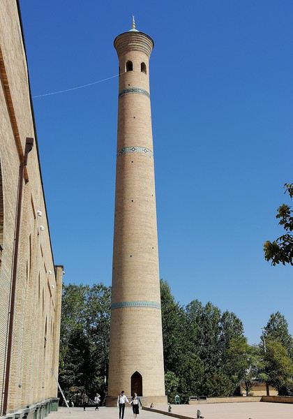
Je rentre d'un voyage à vélo en Ouzbékistan le long de la partie de la Route de la Soie entre Tachkent (où je suis arrivé par avion) et Khiva (que j'ai quitté par train de nuit pour retourner à Tachkent prendre l'avion de retour). Ci-dessous un résumé qui pourrait servir à ceux qui envisagent de faire le même trajet.
1. Aspects généraux : - A l'arrivée, j'avais organisé avec un taxi suffisamment grand pour charger le vélo dans son carton (10$ depuis l'aéroport) avec l'hôtel Art. L'hôtel m'a aussi permis de laisser le carton pendant ma randonnée, pour le retrouver à l'arrivée. L'hôtel est en fait un groupe d'hôtels, comprenant entre autres un hostel (chambres communes, 12 US$/nuit) et des hôtels plus classiques (dont l'hôtel Art, Rakatboshi Street, que j'ai utilisé, 27 US$/nuit). J'ai fait les réservations par Whattsap au +998 90 167 8337. - J'ai pu changer des dollars contre des sums dans un petit guichet situé à l'arrivée-bagages. Le guichet était ouvert à 5h du matin. - Il n'y a aucun formulaire de déclaration de devises à remplir. Comme citoyen suisse, je n'ai pas eu besoin de visa. J'ai passé la douane en une minute avec mon carton, en passant du côté vert "Nothing to declare". Tout cela est assez inattendu, il y a d'habitude beaucoup plus de complications à l'arrivée dans les pays de l'ex-URSS. - Il ne faut prendre que des dollars US : cette monnaie représente la seconde monnaie du pays. L'euro est quasiment inconnu en dehors des banques. Beaucoup de services peuvent se payer indifféremment en dollars ou en sums; il n'y a pas de marché parallèle (le taux officiel s'étant aligné sur le taux du marché noir il y a quelques années; en septembre - octobre 2019 le taux était environ de 9'400 sums pour un dollar US). -Les hôtels sont censés délivrer un coupon attestant de votre séjour dans leur établissement ("Registration slip"), la police des frontières étant censée vérifier qu'on a dormi chaque soir dans un hôtel (sous peine de complications au moment de quitter le pays). J'ai donc benoîtement collectionné ces coupons pour les montrer à la sortie du territoire. Le policier qui a tamponné mon passeport n'y a pas jeté le moindre coup d’œil, et a même haussé les épaules quand je lui ai montré les coupons. - Je n'ai pas pris de tente, mais seulement un sac de couchage. Le seul endroit où la tente aurait été très utile aura été pendant les 300 kms de la traversée du désert du Kyzylkum, entre Gazni et Tortkol. J'ai dormi à Gazni dans une tchaikhana, la première à droite dans la direction de Tortkol. J'ai vu le lendemain, quand j'ai quitté cette tchaikhana, une enseigne indiquant "Hostel" environ 300 m plus loin, toujours sur la droite. Je n'ai pas vérifié si l'hostel fonctionnait réellement. J'ai dormi dans une seconde tchaikhana le lendemain (d'autres établissements ne m'ont pas permis d'utiliser leur installation pour sortir mon sac de couchage). - Le voyage m'a coûté en moyenne 30 dollars par jour (incluant hôtels, repas, entrées dans les sites touristiques, train de nuit Khiva-Tachkent), en comprenant des arrêts de 3-4 jours à Tachkent, Samarcande, Boukhara et Khiva. - J'ai acheté une carte SIM locale chez Ucell à Tachkent (métro Abdulla Qodirii, coordonnées GPS : 41°19'01''N, 69°16'56.02''E), avec 8GB de données pour 105'000 sums (environ 16 $US). La couverture réseau (accès à Internet a été bonne à moyenne pendant tout le trajet.
2. Le trajet en vélo : - Le trajet Tachkent - Khiva (1'100 km) a été bouclé en 9 étapes. - On peut circuler à vélo sur toutes les routes. Celles reliant les principales villes sont comparables à ce qu'on appelle des "quatre-voies" en France. Ces routes ont un revêtement allant de très mauvais à moyen-bas, sauf les 200 kms de route qui traverse le désert du Kyzylkum, qui sont un véritable billard. - Les routes sont surchargées, et les Ouzbeks conduisent de façon dangereuse (y compris pour eux-mêmes : personne ne porte la ceinture de sécurité dans les véhicules). De plus, à part dans les villages, aucun Ouzbek ne va à vélo, ce qui fait que les conducteurs fonctionnent comme si les cyclistes étaient transparents. Un rétroviseur sur le vélo est essentiel. Il y n'y a pratiquement pas d'itinéraires secondaires, les routes alternatives ne sont pas entretenues et sont habituellement en très mauvais état. Il faut noter plusieurs villages dans la même province peuvent porter le même nom, ce qui peut compliquer la navigation GPS (c'est vrai autour de Tachkent, et je ne me suis rendu compte que je me dirigeais sur le mauvais village pour sortir de la ville qu'après une quinzaine de kms). - Il fait chaud à très chaud pendant la seconde moitié de septembre. La température descend au-dessous de 30°C pendant la journée au cours de la première semaine d'octobre. On trouve à boire sans problème le long des routes; il faut cependant noter que les tchaikhanas indiqués par Open Street Map lors de la traversée du Kyzylkum sont souvent désaffectées ou abandonnées. Les nuits peuvent être fraîches à partir de début octobre. Pas de pluie pendant mon trajet; le vent peut être d'intensité moyenne, sa direction est variable (j'ai eu un vent de 3/4 face pendant la traversée du Kyzylkum). - On trouve généralement des hôtels de confort moyen à bas dans les villes. Il n'y a en général pas de problèmes de restauration : les tchaikhanas servent habituellement un excellent lagman (soupe aux nouilles); les plovs sont proposés moins souvent. Les samosas (comca en caractères cyrilliques) sont proposés partout; c'est ce que les Ouzbeks souvent prennent au petit-déjeuner. - Les trains prennent les vélos sans problèmes (en tout cas le train de nuit Khiva-Tachkent).
En résumé : - Le trajet en lui-même en vélo n'est pas intéressant. Ce millier de kilomètres est très plat et très monotone (même la montée vers Samarcande, qui est à 800 m d’altitude), et rendu compliqué par la conduite automobile agressive. - Les villes principales le long de la Route de la Soie sont très belles, au moins leur partie ancienne. Les petites villes ou villages traversés en chemin n'offre à-peu-près aucun intérêt. - Je ne me suis jamais senti en insécurité en Ouzbékistan (sauf sur le vélo et dans le trafic automobile local).
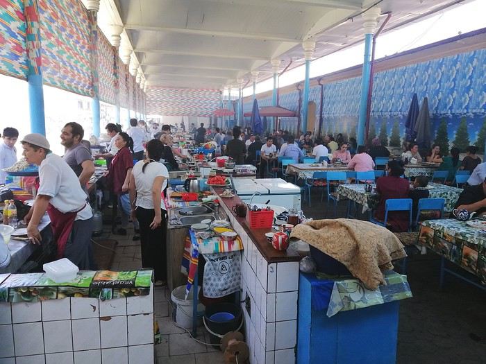
1. Aspects généraux : - A l'arrivée, j'avais organisé avec un taxi suffisamment grand pour charger le vélo dans son carton (10$ depuis l'aéroport) avec l'hôtel Art. L'hôtel m'a aussi permis de laisser le carton pendant ma randonnée, pour le retrouver à l'arrivée. L'hôtel est en fait un groupe d'hôtels, comprenant entre autres un hostel (chambres communes, 12 US$/nuit) et des hôtels plus classiques (dont l'hôtel Art, Rakatboshi Street, que j'ai utilisé, 27 US$/nuit). J'ai fait les réservations par Whattsap au +998 90 167 8337. - J'ai pu changer des dollars contre des sums dans un petit guichet situé à l'arrivée-bagages. Le guichet était ouvert à 5h du matin. - Il n'y a aucun formulaire de déclaration de devises à remplir. Comme citoyen suisse, je n'ai pas eu besoin de visa. J'ai passé la douane en une minute avec mon carton, en passant du côté vert "Nothing to declare". Tout cela est assez inattendu, il y a d'habitude beaucoup plus de complications à l'arrivée dans les pays de l'ex-URSS. - Il ne faut prendre que des dollars US : cette monnaie représente la seconde monnaie du pays. L'euro est quasiment inconnu en dehors des banques. Beaucoup de services peuvent se payer indifféremment en dollars ou en sums; il n'y a pas de marché parallèle (le taux officiel s'étant aligné sur le taux du marché noir il y a quelques années; en septembre - octobre 2019 le taux était environ de 9'400 sums pour un dollar US). -Les hôtels sont censés délivrer un coupon attestant de votre séjour dans leur établissement ("Registration slip"), la police des frontières étant censée vérifier qu'on a dormi chaque soir dans un hôtel (sous peine de complications au moment de quitter le pays). J'ai donc benoîtement collectionné ces coupons pour les montrer à la sortie du territoire. Le policier qui a tamponné mon passeport n'y a pas jeté le moindre coup d’œil, et a même haussé les épaules quand je lui ai montré les coupons. - Je n'ai pas pris de tente, mais seulement un sac de couchage. Le seul endroit où la tente aurait été très utile aura été pendant les 300 kms de la traversée du désert du Kyzylkum, entre Gazni et Tortkol. J'ai dormi à Gazni dans une tchaikhana, la première à droite dans la direction de Tortkol. J'ai vu le lendemain, quand j'ai quitté cette tchaikhana, une enseigne indiquant "Hostel" environ 300 m plus loin, toujours sur la droite. Je n'ai pas vérifié si l'hostel fonctionnait réellement. J'ai dormi dans une seconde tchaikhana le lendemain (d'autres établissements ne m'ont pas permis d'utiliser leur installation pour sortir mon sac de couchage). - Le voyage m'a coûté en moyenne 30 dollars par jour (incluant hôtels, repas, entrées dans les sites touristiques, train de nuit Khiva-Tachkent), en comprenant des arrêts de 3-4 jours à Tachkent, Samarcande, Boukhara et Khiva. - J'ai acheté une carte SIM locale chez Ucell à Tachkent (métro Abdulla Qodirii, coordonnées GPS : 41°19'01''N, 69°16'56.02''E), avec 8GB de données pour 105'000 sums (environ 16 $US). La couverture réseau (accès à Internet a été bonne à moyenne pendant tout le trajet.
2. Le trajet en vélo : - Le trajet Tachkent - Khiva (1'100 km) a été bouclé en 9 étapes. - On peut circuler à vélo sur toutes les routes. Celles reliant les principales villes sont comparables à ce qu'on appelle des "quatre-voies" en France. Ces routes ont un revêtement allant de très mauvais à moyen-bas, sauf les 200 kms de route qui traverse le désert du Kyzylkum, qui sont un véritable billard. - Les routes sont surchargées, et les Ouzbeks conduisent de façon dangereuse (y compris pour eux-mêmes : personne ne porte la ceinture de sécurité dans les véhicules). De plus, à part dans les villages, aucun Ouzbek ne va à vélo, ce qui fait que les conducteurs fonctionnent comme si les cyclistes étaient transparents. Un rétroviseur sur le vélo est essentiel. Il y n'y a pratiquement pas d'itinéraires secondaires, les routes alternatives ne sont pas entretenues et sont habituellement en très mauvais état. Il faut noter plusieurs villages dans la même province peuvent porter le même nom, ce qui peut compliquer la navigation GPS (c'est vrai autour de Tachkent, et je ne me suis rendu compte que je me dirigeais sur le mauvais village pour sortir de la ville qu'après une quinzaine de kms). - Il fait chaud à très chaud pendant la seconde moitié de septembre. La température descend au-dessous de 30°C pendant la journée au cours de la première semaine d'octobre. On trouve à boire sans problème le long des routes; il faut cependant noter que les tchaikhanas indiqués par Open Street Map lors de la traversée du Kyzylkum sont souvent désaffectées ou abandonnées. Les nuits peuvent être fraîches à partir de début octobre. Pas de pluie pendant mon trajet; le vent peut être d'intensité moyenne, sa direction est variable (j'ai eu un vent de 3/4 face pendant la traversée du Kyzylkum). - On trouve généralement des hôtels de confort moyen à bas dans les villes. Il n'y a en général pas de problèmes de restauration : les tchaikhanas servent habituellement un excellent lagman (soupe aux nouilles); les plovs sont proposés moins souvent. Les samosas (comca en caractères cyrilliques) sont proposés partout; c'est ce que les Ouzbeks souvent prennent au petit-déjeuner. - Les trains prennent les vélos sans problèmes (en tout cas le train de nuit Khiva-Tachkent).
En résumé : - Le trajet en lui-même en vélo n'est pas intéressant. Ce millier de kilomètres est très plat et très monotone (même la montée vers Samarcande, qui est à 800 m d’altitude), et rendu compliqué par la conduite automobile agressive. - Les villes principales le long de la Route de la Soie sont très belles, au moins leur partie ancienne. Les petites villes ou villages traversés en chemin n'offre à-peu-près aucun intérêt. - Je ne me suis jamais senti en insécurité en Ouzbékistan (sauf sur le vélo et dans le trafic automobile local).
Hébergement entre Manang et Jomson par le trek de Tilicho
Bonjour,
Est ce que quelqu'un peut me dire si il y a possibilité de dormir entre Manang et Jomson par le Tilicho trek. Apparemment, il y a qq chose au Camp de Base du Tilicho et ensuite un tea shop ou on peut ptt dormir (?) Et ensuite ?? C'est pour éviter de porter la tente. Ensuite, est ce possible de faire Tilicho BC - Jomson en une journée ? OU le tea- shop -Jomson ? (en marchant vite bien sûr ;-) Merci d'avance pour vos réponse.
Est ce que quelqu'un peut me dire si il y a possibilité de dormir entre Manang et Jomson par le Tilicho trek. Apparemment, il y a qq chose au Camp de Base du Tilicho et ensuite un tea shop ou on peut ptt dormir (?) Et ensuite ?? C'est pour éviter de porter la tente. Ensuite, est ce possible de faire Tilicho BC - Jomson en une journée ? OU le tea- shop -Jomson ? (en marchant vite bien sûr ;-) Merci d'avance pour vos réponse.
Arriver avec un drone à l'aéroport de Tachkent
Bonjour,
Il est interdit, sauf autorisation, d'apporter ou d'utiliser un drone en Ouzbékistan. Plusieurs voyageurs ont eu leur drone saisit et/ou détruit à la douane, notamment les frontières terrestres. Mais j'ai lu dans quelques forums anglophones qu'en déclarant spontanément son drone à l'arrivée à l'aéroport de Tachkent, il était peut-être possible de le laisser "en consigne" à la douane et de le récupérer en repartant. Quelqu'un a t-il un retour d'expérience sur le sujet ? En effet on va passer d'abord 2 semaines au Kirghisztan où le drone est autorisé et j'aimerais bien trouver une solution pour ne pas avoir de problème en arrivant en Ouzbékistan.
Merci de vos retours.
Il est interdit, sauf autorisation, d'apporter ou d'utiliser un drone en Ouzbékistan. Plusieurs voyageurs ont eu leur drone saisit et/ou détruit à la douane, notamment les frontières terrestres. Mais j'ai lu dans quelques forums anglophones qu'en déclarant spontanément son drone à l'arrivée à l'aéroport de Tachkent, il était peut-être possible de le laisser "en consigne" à la douane et de le récupérer en repartant. Quelqu'un a t-il un retour d'expérience sur le sujet ? En effet on va passer d'abord 2 semaines au Kirghisztan où le drone est autorisé et j'aimerais bien trouver une solution pour ne pas avoir de problème en arrivant en Ouzbékistan.
Merci de vos retours.
La Chine facile sans circuit?
Bonjour
J'envisage un voyage en chine et voulais savoir s'il il était facile ou non de voyager seul ( enfin en couple ) mais sans circuit organisé, ce que je n'aime pas du tout 😕 Nous partons toujours en road trip sur les US régulièrement et j'aimerais faire pareil en chine. Merci pour vos infos ! 😉
Augmentation des frais de visa pour l'Inde
Encore une fois l'Inde augmente ses frais de visa. Une demande de visa (toutes catégories confondues) coûte désormais 25 € de plus, soit 130 € pour les touristes et 190 € pour les voyageurs d'affaires.
Lire la suite...
Carnet de route Oman février 2019
Bonjour à tous,
je suis toujours à Oman, mais comme les liaisons sont bonnes, je vais essayer de faire mon carnet au fur et à mesure.
Pas de photos, elles sont sur mon site ICI (euh en fait cela sera un peu plus tard ….. et mieux rédigé surement)
Comme d'habitude dans mes voyages, et comme beaucoup j'adore m'occuper de tout, donc Madame ne sait pas trop, d'ailleurs c'est son cadeau de Noël.
Les hôtels (pas de camping, pas trop notre truc) sont réservés depuis la France, le 4*4 aussi.
J'ai eu la chance d'avoir pu acheter un OOR en France dans le bon coin, de quelqu'un qui rentrait juste. Pratiquement neuf, le pied !
Bon je commence :
Dimanche 17 C’est le départ ! 3h45 on ferme la maison et direction aéroport. Un arrêt au parking extérieur et c’est à 4h45que l’on arrive pour l’embarquement pour un vol à 7h. On pense être cool, mais quelle surprise de voir une queue énorme pour les choses administratives. KLM/Air France sont vraiment spécialistes. Personne ailleurs, ah si en fait beaucoup plus de guichets ouverts ailleurs. Vol Lyon Amsterdam sans soucis avec des prestations low-cost, mais bon on est à l’heure. Deux heures d’attente à Shipol et décollage vers Damman en Arabie Saoudite. Le plan de vol annoncé sur les écrans change ! Au lieu de survoler le Liban, la Syrie et l’Irak, on passe au sud vers l’Egypte puis l’Arabie Saoudite. Curieux, j'aurai tant aimé survolé ces pays accueillants en ce moment !! Une belle vue sur le désert donne envie de voir du désert…. Patience Escale technique à Damman, où les seuls à descendre sont des hommes venant travailler en AS et une famille que j’imagine être saoudienne. Ensuite petit vol vers Mascate, arrivée à l’heure. Après le train train habituel, l’immigration, avec le visa pris par internet, on gagne du temps, récupération des bagages, puis la voiture. Chez Europcar, pas d’attente, on nous propose donc un toyota fortuner. C’est un 4*4, donc l’essentiel. Je branche le GPS et hop c’est parti, euh non pas vraiment car il ne trouve pas mon adresse. Petit moment de panique, je décide d’y aller au nez (j’avais en tête un peu le plan de la ville). Après un arrêt et un reboostage du bébé, hop, il fonctionne et on se trouve à 5 min de l’hôtel. Accueil sympa, douche et dodo car depuis 3h00 ce matin même s’il n’est que 21h en France, ça fait beaucoup !
Le + : On y est !! Le - : KLM/Air France, cela devient du low cost
Dimanche 17 C’est le départ ! 3h45 on ferme la maison et direction aéroport. Un arrêt au parking extérieur et c’est à 4h45que l’on arrive pour l’embarquement pour un vol à 7h. On pense être cool, mais quelle surprise de voir une queue énorme pour les choses administratives. KLM/Air France sont vraiment spécialistes. Personne ailleurs, ah si en fait beaucoup plus de guichets ouverts ailleurs. Vol Lyon Amsterdam sans soucis avec des prestations low-cost, mais bon on est à l’heure. Deux heures d’attente à Shipol et décollage vers Damman en Arabie Saoudite. Le plan de vol annoncé sur les écrans change ! Au lieu de survoler le Liban, la Syrie et l’Irak, on passe au sud vers l’Egypte puis l’Arabie Saoudite. Curieux, j'aurai tant aimé survolé ces pays accueillants en ce moment !! Une belle vue sur le désert donne envie de voir du désert…. Patience Escale technique à Damman, où les seuls à descendre sont des hommes venant travailler en AS et une famille que j’imagine être saoudienne. Ensuite petit vol vers Mascate, arrivée à l’heure. Après le train train habituel, l’immigration, avec le visa pris par internet, on gagne du temps, récupération des bagages, puis la voiture. Chez Europcar, pas d’attente, on nous propose donc un toyota fortuner. C’est un 4*4, donc l’essentiel. Je branche le GPS et hop c’est parti, euh non pas vraiment car il ne trouve pas mon adresse. Petit moment de panique, je décide d’y aller au nez (j’avais en tête un peu le plan de la ville). Après un arrêt et un reboostage du bébé, hop, il fonctionne et on se trouve à 5 min de l’hôtel. Accueil sympa, douche et dodo car depuis 3h00 ce matin même s’il n’est que 21h en France, ça fait beaucoup !
Le + : On y est !! Le - : KLM/Air France, cela devient du low cost
Voyager en hiver à vélo (France)
Bonjour à vous tous.
Lors de mes prochaines vacances, du 10 au 20 février, j'aimerai entreprendre un voyage en vélo en partant de Caen et à destination de Nantes puis continuer en bretagne en fonction de la vitesse à laquelle j'avancerai. J'ai déjà fait un voyage l'été dernier, il s'agissait de mon premier. Or, j'aimerai avoir quelques conseils sur le matériel nécessaire en hiver. J'aimerai utiliser warmshower ainsi que m'arrêter chez des amis pour dormir, mais je vais aussi, très certainement, être dans la nécessité de dormir en extérieur (tente).
Bien évidemment, les températures sont beaucoup moins agréables que l'été ... ihi et pour faire de bonnes nuits j'aimerai avoir quelques conseils pour l'achat de matériel (duvet, vêtements chauds, gants, bonnets etc.) qui soient confortables.
J'aimerai ne pas avoir à dépenser trop d'argent, notamment pour le duvet (même si il semblerait que le prix monte assez vite) et la matelas isolant du sol (ou si vous avez d'autres idées pour le couchage).
Merci pour vos conseils !
Lors de mes prochaines vacances, du 10 au 20 février, j'aimerai entreprendre un voyage en vélo en partant de Caen et à destination de Nantes puis continuer en bretagne en fonction de la vitesse à laquelle j'avancerai. J'ai déjà fait un voyage l'été dernier, il s'agissait de mon premier. Or, j'aimerai avoir quelques conseils sur le matériel nécessaire en hiver. J'aimerai utiliser warmshower ainsi que m'arrêter chez des amis pour dormir, mais je vais aussi, très certainement, être dans la nécessité de dormir en extérieur (tente).
Bien évidemment, les températures sont beaucoup moins agréables que l'été ... ihi et pour faire de bonnes nuits j'aimerai avoir quelques conseils pour l'achat de matériel (duvet, vêtements chauds, gants, bonnets etc.) qui soient confortables.
J'aimerai ne pas avoir à dépenser trop d'argent, notamment pour le duvet (même si il semblerait que le prix monte assez vite) et la matelas isolant du sol (ou si vous avez d'autres idées pour le couchage).
Merci pour vos conseils !
Quelle île thaïlandaise choisir quand on est avec un enfant?
Bonjour à tous,
Nous partons avec mon mari et notre fille de 18 mois en Thailande en février 2019. Nous restons 15 jours sur place. Nous comptons passer 1/2j à Bangkok en arrivant pour voir comment notre fille s'acclimate et on refera 1/2j à la fin de notre voyage avant de reprendre l'avion. Nous allons aller par avion à Chang Maï 4/5j et faire ensuite une île pour se relaxer et plonger. Quelle(s) île(s) nous conseillerez-vous en sachant qu'avec un bébé, on n'est pas en mode grosse teuf ? Des amis nous ont parlé de Koh Tao, Koh Lipe et Koh Chang. On a 7j pour les îles, donc on pourrait aller sur deux îles (Koh Samoui/Koh Tao par ex.) Pour Koh lipe, je crois qu'il y a pas mal de temps de traversée pour rejoindre l'île...
On est un peu perdu avec toutes les choix possibles donc un peu d'aide et de conseils nous faciliterait bien la tâche.
Merci d'avance, Aurore
Nous partons avec mon mari et notre fille de 18 mois en Thailande en février 2019. Nous restons 15 jours sur place. Nous comptons passer 1/2j à Bangkok en arrivant pour voir comment notre fille s'acclimate et on refera 1/2j à la fin de notre voyage avant de reprendre l'avion. Nous allons aller par avion à Chang Maï 4/5j et faire ensuite une île pour se relaxer et plonger. Quelle(s) île(s) nous conseillerez-vous en sachant qu'avec un bébé, on n'est pas en mode grosse teuf ? Des amis nous ont parlé de Koh Tao, Koh Lipe et Koh Chang. On a 7j pour les îles, donc on pourrait aller sur deux îles (Koh Samoui/Koh Tao par ex.) Pour Koh lipe, je crois qu'il y a pas mal de temps de traversée pour rejoindre l'île...
On est un peu perdu avec toutes les choix possibles donc un peu d'aide et de conseils nous faciliterait bien la tâche.
Merci d'avance, Aurore
Voyage camping-car jusqu'à Irkoutsk et croisière sur le lac Baïkal
En 2019 j'envisage de me rendre en camping car jusqu'à Irkoutsk et d'effectuer une croisière de 6 jours sur le lac Baïkal.
Je prévois de suivre le même itinéraire et les mêmes étapes que le Paris Pékin pour la partie Russe.
Je sollicite les camping caristes qui auraient déjà effectué ce parcours pour m'indiquer les sites de bivouac (adresses, coordonnées gps , etc)qu'ils ont utilisés sur le parcours.
Remerciements par avance
moutarin 38
Kayaking in Greenland - Disko Bay: Circumnavigation of Arve Princess Island
After two rather rainy kayaking experiences in Alaska at the end of summer in recent years, we chose a slightly drier destination for this late August 2018: the west coast of Greenland. The temperature will certainly be a bit colder, especially at this time of year, but we’re betting on a beautiful end to the season. According to temperature charts, it should be around 5 to 10°C with a few night frosts. The tundra will already have its autumn colors, and by the end of the trip, we might be lucky enough to see the northern lights when the nights get darker.
We’re setting off as a group of three in two inflatable double-seater kayaks (Gumotex) brought from France. The plan is to spend two weeks circumnavigating Arve Princess Island, located north of Ilulissat in Disko Bay, with a possible boat drop-off at the southern tip of the island.
This seems like a fairly classic route in the area—we found several descriptions online (thanks to the authors). With their help and Google Earth, we identified all potential campsites and entered their coordinates into a GPS. The western part of the island, facing the bay, seems ideal for whale watching, while the more rugged eastern side offers access to several glacial walls. We’re somewhat familiar with the area from two winter expeditions on skis and pulkas.
Plus, the commitment is limited due to the island’s proximity to several small villages, including Qeqertaq, Oqaatsut, and even Ilulissat. In fact, we saw fishing boats almost every day. The distance suits us well: 200 kilometers in 16 full days on site, which should leave some leeway in case of bad weather or for hiking.
We booked our flights in June with Air Greenland to Ilulissat for the last week of August and the first week of September. On both the outbound and return trips, we stayed overnight in Copenhagen. The France-Copenhagen flight was with Air France.
We were allowed 3 x 20 kg in the hold. Each kayak with its accessories fits into a 20 kg bag; the last hold bag is for shared gear: tent, stoves, dry bags… We only brought 1.5 kg of semolina for food. In the end, we had 61 kg of gear, and no excess baggage was charged.
Individual gear (clothes and sleeping bags…) was distributed in the cabin luggage.
For the boat transfer, we contacted an agency: Blue Jay, which gave us a number to call upon arrival.
Day 0: Wednesday, August 22 Departure day. After work, I drove from Gap to Marseille’s Marignane Airport for the first leg of the trip to Copenhagen. I enjoyed the rather mild local temperatures: 35°C in the shade. After a layover in Paris, I arrived at the Copenhagen hotel, located two train stops from the airport, where my companions were already settled. No issues—everyone was on time with their luggage.
Day 1 The flight to Greenland was at 9 AM. We had a layover in Kangerlussuaq, where we changed planes, then stopped in Aasiaat before reaching Ilulissat Airport at 3 PM under beautiful sunshine.
We called Blue Jay for the boat transfer: they could take us to the island as early as 6 PM; otherwise, we’d have to wait until the next day. That left us 3 hours to prepare our gear and, most importantly, do our shopping for the two-week trip—it seemed tight, but we gave it a shot.
A quick taxi ride took us to Pisiffik, where we easily found everything we needed: bread, butter, cheese, cold cuts, rice, pasta, jam, muesli… There was no C fuel or methylated spirits for the stoves, but this time we knew the trick: at Stark, a bit uphill from the town, we found the precious liquids. Two hours later, we filled our dry bags and containers with our purchases, and by 5:30 PM, we met Klaus, the Blue Jay manager, directly at the port.
The vacation seemed to truly begin as we sped by boat through the icebergs toward Arve Princess Island. Forty-five minutes later, we spotted a beach lined with rocks where Klaus dropped us off quickly (he had another transfer to make right after).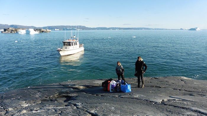
Here we were on the island, in the middle of nowhere, with all our luggage and food to organize, the tent to set up, and the kayaks to inflate—just 10 hours after leaving the Copenhagen hotel. We got to work, bothered by the flies. Despite our head nets, it was barely tolerable—there were so many of them. They swarmed by the dozens into every bag we opened. It was quite mild: 10°C.
Everything was ready by evening, and we were very happy to have completed all these transfers (planes and boat in a single day) as we slipped into our sleeping bags.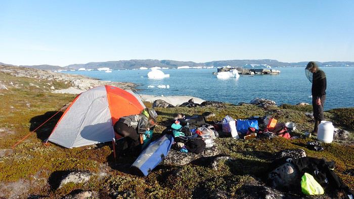
During the night, the wind picked up, and we went out several times to check the tent and kayak anchors. We noticed how bright it was—it was still quite twilight even at 1 AM.
Day 2 5:30 AM wake-up—the south wind was still strong, but since we were heading north, we decided to give it a try anyway.
This was also the moment we loaded the kayaks: since there were only three of us for two double-seater kayaks, we filled the hatch of one kayak, which allowed us to fit all our food. It would have been very difficult if there had been four of us for two kayaks.
Finally, we set off north along the western coast of the island. The conditions were far from ideal—the sea was rough, and the kayaks had a lot of wind resistance. But the main problem was the spray skirt: the gear on deck weighed it down, and the skirt kept coming off… We’d have to deal with it. Barely underway, and whales were already breaking the surface—it was our first time seeing them, and we were very impressed. Too bad the wind didn’t allow for longer contemplation; stopping paddling was impossible with such strong gusts.
We passed a few headlands and even considered stopping due to the conditions. To find some semblance of shelter, we had to hug the coast closely without cutting across the numerous bays, which significantly lengthened the journey. But as the morning went on, the wind died down, and the sea calmed. We spotted several whales and our first seals. It was almost pleasant during the picnic break. By late afternoon, we reached Kangerup Sarqâ Bay, where we had identified a great campsite with a very large beach and a river. But the wind had shifted—it was now coming from the north, making the last hour difficult due to fatigue and headwinds.
The campsite was ideal and beautiful, facing numerous icebergs grounded in the bay.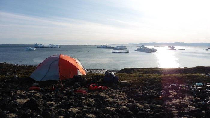
The GPS alerted us to another major drawback of inflatable kayaks: their slowness. It took us 7.5 hours of actual paddling (excluding breaks) to cover 28 km, averaging 3.7 km/h—somewhat disappointing. But we knew this before leaving, and once again, we’d have to make do!
Day 3 Surprise: at 6 AM wake-up, it was raining, foggy, with a south wind, and the sea was choppy even in the bay. It seemed wise to skip paddling, even though stopping on the second day was tough on morale. We went back to sleep, especially since the travel fatigue and the harsh conditions of the previous day had taken their toll.
At 11 AM, the navigation conditions weren’t any better—at the ends of the bay, we saw huge waves crashing onto the rocks, and giving up for the day became obvious. However, the rain had stopped, so we set off for a hike along the large lake bordering the bay. The wind hadn’t let up, and it was quite cold.
The tundra was starting to take on its autumn colors, and the contrast between the white lichens and the red vegetation was stunning. At the lake, we took out the fishing rods and quickly caught two beautiful Arctic char over 50 cm long.
As the afternoon wore on, the sun seemed closer. Along the beach, we gathered driftwood (mostly old planks) to cook our catch in foil over a fire. Eating our own food in such a beautiful place next to a good fire was comforting after the day’s setback.
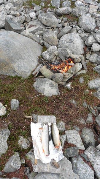
In the middle of the night, an Arctic fox entered the tent’s rear awning. It seemed barely intimidated when we shooed it away with loud shouts and then with stones.
Day 4 6:15 AM wake-up—3°C. We were on the water by 8 AM. The wind had dropped significantly, but the sea was shrouded in fog, and it was very cold in these damp conditions.
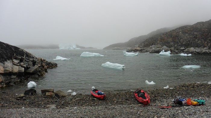
We passed the bay’s headland, Kangea, and headed toward the abandoned village of Agpat. The atmosphere was very austere—we hugged black rocks in fog that limited visibility to 50 meters, revealing large icebergs as we went.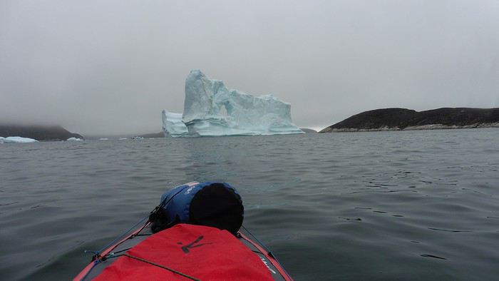
Suddenly, the water’s surface stirred in front of my kayak, and a huge gray back emerged from the sea. The collision was inevitable, but the whale seemed to understand and dove immediately, passing under the kayak and resurfacing a few meters away. I felt the kayak rock in the white foam and quickly paddled to escape the turbulence. What an emotion!
A light wind began to clear the fog, and the sun made beautiful appearances. Despite the cold, we stopped to visit the abandoned village, which left a strange impression. All the houses were still in good condition and wide open—some must have been very spacious in their time. We went back to sea, and in front of the large Kaangerdluk Bay, we hesitated—the headwind was strong, and large waves split the water. The next beach, from the island of Nua where we stopped to think, was over 8 km away. It was barely 2 PM, but caution led us to stop here for the day. We had covered 12 km—exactly the distance needed to stay on schedule. The afternoon was spent hiking on the island’s hills and gathering mussels and wood.
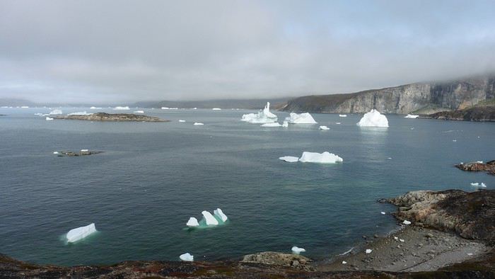
In the evening, we cooked these large Greenlandic mussels over a wood fire and savored them under the beautiful evening light. The weather was now fine, but the thermometer read -5°C in the sun…
Day 5 Bright sunshine, a glassy sea, and -8°C at 6 AM. Everything was green for setting off, even if putting on damp kayaking gear was a bit unpleasant in the cold. It was the first time we’d paddled on a flat sea since the start of the trip, and our average speed increased slightly.
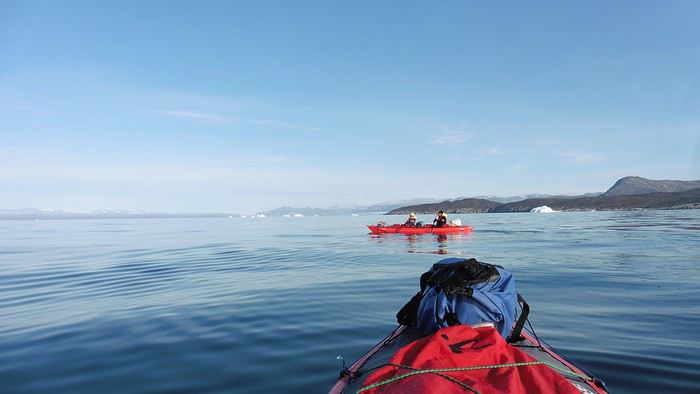
We entered the Smallesund Strait, marking the end of the island’s west coast. We were close to the large Torssukatak Fjord, where two glaciers flow. The access pass to the fjord was very narrow, and numerous ice chunks blocked access to the beaches. The wind had picked up and was now hitting us head-on (again). Just before entering the fjord, we landed on a steep beach made of large pebbles on Oqaitsut Island. It was very cold with the wind, and moving forward became difficult. We decided to stop for the day both because of the conditions and because the next campsite was far away, given how rugged the fjord was.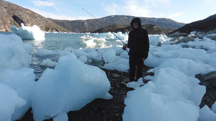
We eventually found a flat spot for the tent despite the steep slope. Even with the wind, the weather was beautiful, and we set off on foot for the northeastern cape of the island, overlooking the fjord. The view was far-reaching and exceptional—up close, the large fjord filled with ice and its steep granite cliffs, and in the distance, the ice cap and glacial walls.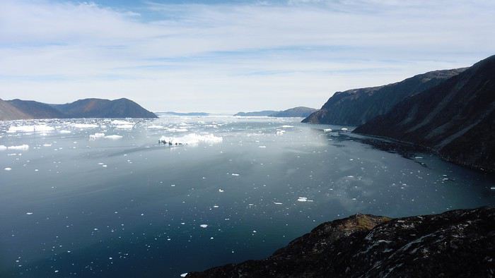
We spotted the village of Qeqertaq, whose network we could pick up, allowing us to check the weather forecast, which was rather good. While securing the kayaks in the evening, I noticed the strange behavior of one kayak at the end of the stage was due to the loss of the skeg—impossible to know where it detached. We’d have to do without it.
Day 6 Still that icy headwind from the northeast. We set off anyway for a long stage to reach the large pass connecting the Torssukatak and Ata Fjords.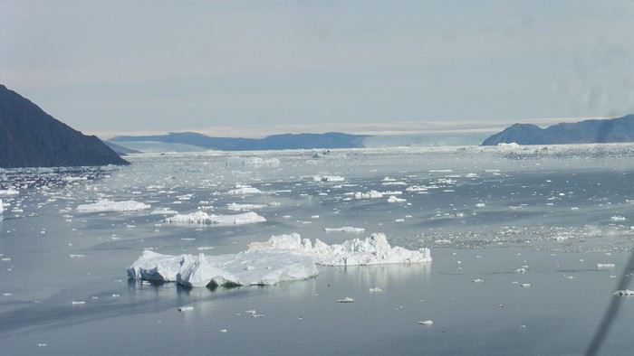
We advanced laboriously along the high cliffs of the fjord’s southern shore. They faced due north and blocked the sun. We felt the cold and dampness of the rock. It was really cold, especially in the extremities. We picnicked on the western cape of Qeqertakavasak Island. The cold didn’t allow us to stop for more than 20 minutes… But the wind dropped, and the sea was now very smooth. It was heavily cluttered with ice between the icebergs and old pack ice. The goal was to reach the large rocky promontory of Anapnuna, wedged between the Kujatdleq and Kangilerngata Glaciers, but the ice made progress difficult. We stopped to gain height on a small island and spot a passage of open water, but all we saw was white—passing seemed impossible. The currents were very complex, and entire sections of ice were being swept in one direction and then another at an impressive speed.
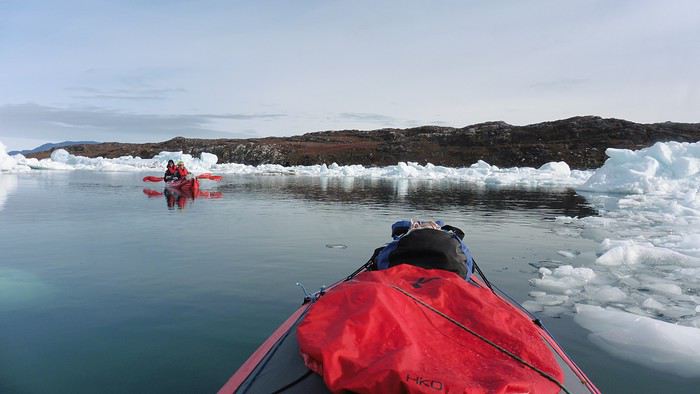
We wandered through this labyrinth until landing on a beach on the small island of Takissut, where we set up camp, exhausted from the 30 km covered and the vigilance required by the abundance of ice. The place was sublime under the evening sun—we were surrounded by ice and mountains, with the Kangilerngata Glacier in the distance. The summer contrasts were striking between the water, icebergs, sky, and flaming tundra—all colors were represented. Absolute calm reigned.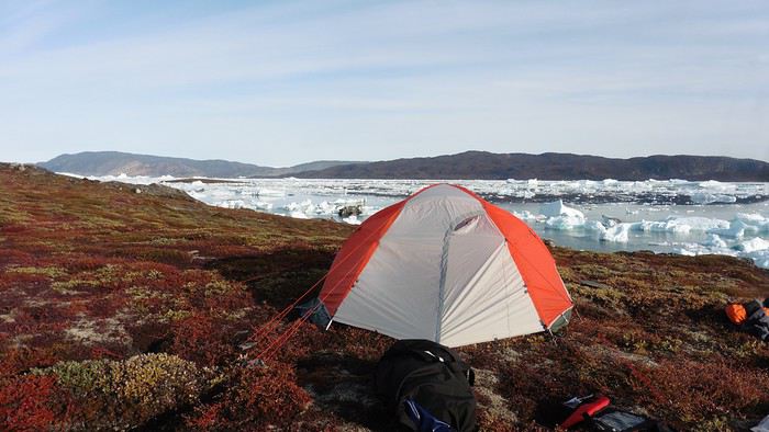
The lack of drinking water at this spot wasn’t too much of a constraint: as soon as we arrived on the beach, we placed containers under the icebergs stranded in the intertidal zone. They were all full by the time we finished setting up.
Day 7 We had to change our plans: we wouldn’t reach the rocky promontory, too well protected by the ice. We set off under the sun for Igdluluarssuit Island. Although we had spotted a passage just before launching, we quickly found ourselves surrounded by ice. It was everywhere, and finding water to paddle became complicated. We tried to force our way in every direction, even retracing our steps. Everything moved at an impressive speed—we were in the middle of a whirlpool of ice.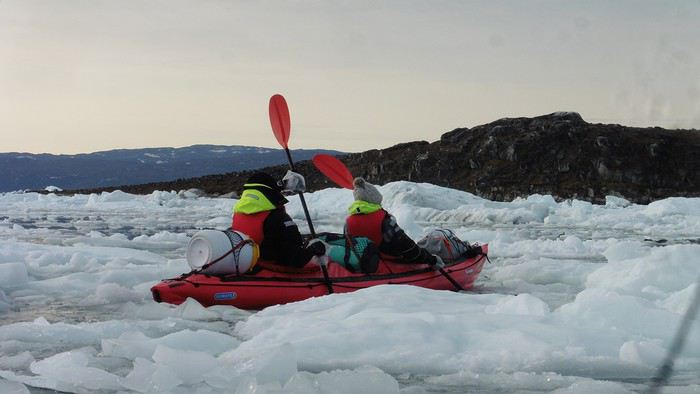
The tension rose, and each boat had its share of big scares. I was trapped against ice floes that dragged me toward an iceberg—the pressure on the kayak was enormous; it was going to capsize or puncture! But with a few strong strokes and paddling against the ice, I managed to free myself from the trap. Barely 10 minutes later, my companions were sandwiched perpendicularly between two icebergs that were closing in. The situation was desperate—the kayak was bending and twisting more and more, but with some strong paddle strokes, it finally freed itself. After these particularly unpleasant moments, we were completely blocked. The drifting ice floes had tightened, and the kayaks were no longer even in the water… The only solution: wait with the kayaks on these floes, which were too thin to walk on (even though we didn’t try). Within minutes, the situation cleared—a waterway opened, and we rushed into it. We paddled with one goal: find a larger pool of water. After going back and forth, our path took shape—we had to force the passage several times, attacking the ice directly with the kayaks, and finally, we escaped the worst of the labyrinth. We reached land on the west side of the island and saw that the rest would be easier. To reach the island, we just had to cross the Arsiviup Ikera Strait, which was lightly cluttered. We reached the eastern cape of the island, ideal for camping, even though we had only paddled for 3 hours. We set up camp and hiked to the island’s summit, which overlooks the entire pass and the glaciers.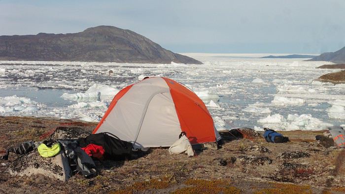
Everything was magnificent, no matter the direction. At 2 PM, we were at the summit—the beauty of the place and the picnic facing the glacier in the sun without wind made us forget the near-disaster from a few hours earlier. It would be impossible to approach the glacier by kayak, but from our summit on foot, it seemed so close, and contemplating it safely on solid ground was a great moment.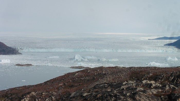
The pass was incredibly complex—everything was in motion, and an impassable passage could become open water within minutes. We were delighted when we returned to camp. A slightly lost whale among the ice accompanied us along the shore. The place was truly beautiful, but the temperature dropped again under the clear sky, preventing us from eating outside.
Day 8 Clear and cold at wake-up: -9°C. The sea had frozen in many places. We hesitated about the rest of the trip—should we start heading back to Ilulissat or linger in the pass, especially to approach the Eqi Glacier? After the incidents of the previous day, we decided to think carefully and paddled to the southern cape of our island to check the ice conditions toward Eqi. The weather had clouded over in the meantime, and the sky was quite gray. At the cape, we spotted the glacier’s wall, still 15 km away.
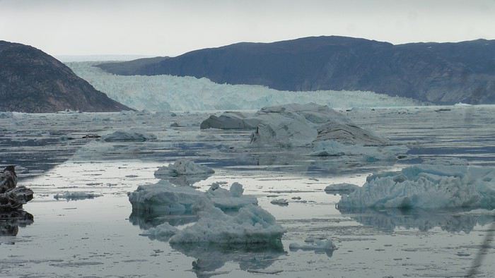
The fjord was quite cluttered, but it seemed passable. However, there was no guarantee the view would be much better 1 km from the glacier than 15 km away, especially since the front was quite active and therefore dangerous. We decided to head south without passing by the glacier. The cold temperatures encountered in the pass also motivated us to move away from the glaciers and the ice cap. We navigated under a threatening sky but without wind. The kayaks cut through the thin layer of ice on the surface with a crinkling paper sound. We reached the Ata campsite in the late afternoon after 5 hours of rowing without a single break…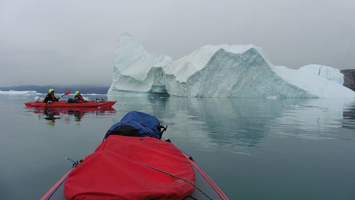
The wind had picked up, and we discovered a nice surprise: a refuge with a table and a comfortable bench lined with mattresses. Facing the worsening weather, we settled in comfortably. The kerosene stove was too complex for our three brains—we couldn’t get it started, too bad, as it was 0°C inside. The rest of the afternoon was spent fishing in the large lake, where we landed a beautiful Arctic char, more than enough for three. A good night’s sleep without the risk of foxes or the sound of a tent shaking in the wind.
Day 9 6 AM wake-up to the sound of rain hitting the cabin. The decision was made looking out the window—wind, rain, and fog obscured the sea: we went back to sleep.
New wake-up, and the rain had stopped—we could go out and stock up on fish. We set off on foot toward the lake, following its western shore. It was very overcast, and the wind encouraged us to keep moving. We made our way to a smaller lake at the end of the large one, where we caught a huge Arctic char. A small clearing brightened the picnic, and we headed back to our cabin.
This 20 km hike kept us busy all day: walking on slippery scree and the micro-relief of the peat bogs took time.
Day 10 The sky was clear, but a light south wind made paddling intense. We set off southeast to reach the opposite shore of the fjord. It was very cold, and it was impossible to stop paddling for even a moment without immediately losing ground due to the wind. We crossed the Kangerluarsuk Fjord. I recognized the cape I had reached on skis in the winter of 2017. We found a nice campsite on the southern shore of the fjord: Uiartag. It wasn’t even noon, but facing this headwind, we preferred to stop here rather than exhaust ourselves for a few extra kilometers. Like the previous ones, this campsite was very comfortable: the ground was covered with a thick layer of lichens and mosses, very pleasant to lie on.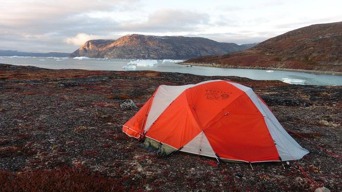
We set off on a hike to the heights of the cape, where the weather alternated between large clearings and snow showers. We noticed the loss of the thermometer, poorly attached to the backpack. On the way back, in the small bay of our beach, a whale swam calmly 10 meters from the shore—a beautiful surprise.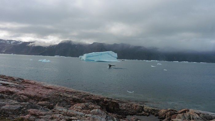
The sky cleared completely, and the temperature dropped as night approached.
We’re setting off as a group of three in two inflatable double-seater kayaks (Gumotex) brought from France. The plan is to spend two weeks circumnavigating Arve Princess Island, located north of Ilulissat in Disko Bay, with a possible boat drop-off at the southern tip of the island.
This seems like a fairly classic route in the area—we found several descriptions online (thanks to the authors). With their help and Google Earth, we identified all potential campsites and entered their coordinates into a GPS. The western part of the island, facing the bay, seems ideal for whale watching, while the more rugged eastern side offers access to several glacial walls. We’re somewhat familiar with the area from two winter expeditions on skis and pulkas.
Plus, the commitment is limited due to the island’s proximity to several small villages, including Qeqertaq, Oqaatsut, and even Ilulissat. In fact, we saw fishing boats almost every day. The distance suits us well: 200 kilometers in 16 full days on site, which should leave some leeway in case of bad weather or for hiking.
We booked our flights in June with Air Greenland to Ilulissat for the last week of August and the first week of September. On both the outbound and return trips, we stayed overnight in Copenhagen. The France-Copenhagen flight was with Air France.
We were allowed 3 x 20 kg in the hold. Each kayak with its accessories fits into a 20 kg bag; the last hold bag is for shared gear: tent, stoves, dry bags… We only brought 1.5 kg of semolina for food. In the end, we had 61 kg of gear, and no excess baggage was charged.
Individual gear (clothes and sleeping bags…) was distributed in the cabin luggage.
For the boat transfer, we contacted an agency: Blue Jay, which gave us a number to call upon arrival.
Day 0: Wednesday, August 22 Departure day. After work, I drove from Gap to Marseille’s Marignane Airport for the first leg of the trip to Copenhagen. I enjoyed the rather mild local temperatures: 35°C in the shade. After a layover in Paris, I arrived at the Copenhagen hotel, located two train stops from the airport, where my companions were already settled. No issues—everyone was on time with their luggage.
Day 1 The flight to Greenland was at 9 AM. We had a layover in Kangerlussuaq, where we changed planes, then stopped in Aasiaat before reaching Ilulissat Airport at 3 PM under beautiful sunshine.
We called Blue Jay for the boat transfer: they could take us to the island as early as 6 PM; otherwise, we’d have to wait until the next day. That left us 3 hours to prepare our gear and, most importantly, do our shopping for the two-week trip—it seemed tight, but we gave it a shot.
A quick taxi ride took us to Pisiffik, where we easily found everything we needed: bread, butter, cheese, cold cuts, rice, pasta, jam, muesli… There was no C fuel or methylated spirits for the stoves, but this time we knew the trick: at Stark, a bit uphill from the town, we found the precious liquids. Two hours later, we filled our dry bags and containers with our purchases, and by 5:30 PM, we met Klaus, the Blue Jay manager, directly at the port.
The vacation seemed to truly begin as we sped by boat through the icebergs toward Arve Princess Island. Forty-five minutes later, we spotted a beach lined with rocks where Klaus dropped us off quickly (he had another transfer to make right after).
Here we were on the island, in the middle of nowhere, with all our luggage and food to organize, the tent to set up, and the kayaks to inflate—just 10 hours after leaving the Copenhagen hotel. We got to work, bothered by the flies. Despite our head nets, it was barely tolerable—there were so many of them. They swarmed by the dozens into every bag we opened. It was quite mild: 10°C.
Everything was ready by evening, and we were very happy to have completed all these transfers (planes and boat in a single day) as we slipped into our sleeping bags.
During the night, the wind picked up, and we went out several times to check the tent and kayak anchors. We noticed how bright it was—it was still quite twilight even at 1 AM.
Day 2 5:30 AM wake-up—the south wind was still strong, but since we were heading north, we decided to give it a try anyway.
This was also the moment we loaded the kayaks: since there were only three of us for two double-seater kayaks, we filled the hatch of one kayak, which allowed us to fit all our food. It would have been very difficult if there had been four of us for two kayaks.
Finally, we set off north along the western coast of the island. The conditions were far from ideal—the sea was rough, and the kayaks had a lot of wind resistance. But the main problem was the spray skirt: the gear on deck weighed it down, and the skirt kept coming off… We’d have to deal with it. Barely underway, and whales were already breaking the surface—it was our first time seeing them, and we were very impressed. Too bad the wind didn’t allow for longer contemplation; stopping paddling was impossible with such strong gusts.
We passed a few headlands and even considered stopping due to the conditions. To find some semblance of shelter, we had to hug the coast closely without cutting across the numerous bays, which significantly lengthened the journey. But as the morning went on, the wind died down, and the sea calmed. We spotted several whales and our first seals. It was almost pleasant during the picnic break. By late afternoon, we reached Kangerup Sarqâ Bay, where we had identified a great campsite with a very large beach and a river. But the wind had shifted—it was now coming from the north, making the last hour difficult due to fatigue and headwinds.
The campsite was ideal and beautiful, facing numerous icebergs grounded in the bay.
The GPS alerted us to another major drawback of inflatable kayaks: their slowness. It took us 7.5 hours of actual paddling (excluding breaks) to cover 28 km, averaging 3.7 km/h—somewhat disappointing. But we knew this before leaving, and once again, we’d have to make do!
Day 3 Surprise: at 6 AM wake-up, it was raining, foggy, with a south wind, and the sea was choppy even in the bay. It seemed wise to skip paddling, even though stopping on the second day was tough on morale. We went back to sleep, especially since the travel fatigue and the harsh conditions of the previous day had taken their toll.
At 11 AM, the navigation conditions weren’t any better—at the ends of the bay, we saw huge waves crashing onto the rocks, and giving up for the day became obvious. However, the rain had stopped, so we set off for a hike along the large lake bordering the bay. The wind hadn’t let up, and it was quite cold.
The tundra was starting to take on its autumn colors, and the contrast between the white lichens and the red vegetation was stunning. At the lake, we took out the fishing rods and quickly caught two beautiful Arctic char over 50 cm long.
As the afternoon wore on, the sun seemed closer. Along the beach, we gathered driftwood (mostly old planks) to cook our catch in foil over a fire. Eating our own food in such a beautiful place next to a good fire was comforting after the day’s setback.
In the middle of the night, an Arctic fox entered the tent’s rear awning. It seemed barely intimidated when we shooed it away with loud shouts and then with stones.
Day 4 6:15 AM wake-up—3°C. We were on the water by 8 AM. The wind had dropped significantly, but the sea was shrouded in fog, and it was very cold in these damp conditions.
We passed the bay’s headland, Kangea, and headed toward the abandoned village of Agpat. The atmosphere was very austere—we hugged black rocks in fog that limited visibility to 50 meters, revealing large icebergs as we went.
Suddenly, the water’s surface stirred in front of my kayak, and a huge gray back emerged from the sea. The collision was inevitable, but the whale seemed to understand and dove immediately, passing under the kayak and resurfacing a few meters away. I felt the kayak rock in the white foam and quickly paddled to escape the turbulence. What an emotion!
A light wind began to clear the fog, and the sun made beautiful appearances. Despite the cold, we stopped to visit the abandoned village, which left a strange impression. All the houses were still in good condition and wide open—some must have been very spacious in their time. We went back to sea, and in front of the large Kaangerdluk Bay, we hesitated—the headwind was strong, and large waves split the water. The next beach, from the island of Nua where we stopped to think, was over 8 km away. It was barely 2 PM, but caution led us to stop here for the day. We had covered 12 km—exactly the distance needed to stay on schedule. The afternoon was spent hiking on the island’s hills and gathering mussels and wood.
In the evening, we cooked these large Greenlandic mussels over a wood fire and savored them under the beautiful evening light. The weather was now fine, but the thermometer read -5°C in the sun…
Day 5 Bright sunshine, a glassy sea, and -8°C at 6 AM. Everything was green for setting off, even if putting on damp kayaking gear was a bit unpleasant in the cold. It was the first time we’d paddled on a flat sea since the start of the trip, and our average speed increased slightly.
We entered the Smallesund Strait, marking the end of the island’s west coast. We were close to the large Torssukatak Fjord, where two glaciers flow. The access pass to the fjord was very narrow, and numerous ice chunks blocked access to the beaches. The wind had picked up and was now hitting us head-on (again). Just before entering the fjord, we landed on a steep beach made of large pebbles on Oqaitsut Island. It was very cold with the wind, and moving forward became difficult. We decided to stop for the day both because of the conditions and because the next campsite was far away, given how rugged the fjord was.
We eventually found a flat spot for the tent despite the steep slope. Even with the wind, the weather was beautiful, and we set off on foot for the northeastern cape of the island, overlooking the fjord. The view was far-reaching and exceptional—up close, the large fjord filled with ice and its steep granite cliffs, and in the distance, the ice cap and glacial walls.
We spotted the village of Qeqertaq, whose network we could pick up, allowing us to check the weather forecast, which was rather good. While securing the kayaks in the evening, I noticed the strange behavior of one kayak at the end of the stage was due to the loss of the skeg—impossible to know where it detached. We’d have to do without it.
Day 6 Still that icy headwind from the northeast. We set off anyway for a long stage to reach the large pass connecting the Torssukatak and Ata Fjords.
We advanced laboriously along the high cliffs of the fjord’s southern shore. They faced due north and blocked the sun. We felt the cold and dampness of the rock. It was really cold, especially in the extremities. We picnicked on the western cape of Qeqertakavasak Island. The cold didn’t allow us to stop for more than 20 minutes… But the wind dropped, and the sea was now very smooth. It was heavily cluttered with ice between the icebergs and old pack ice. The goal was to reach the large rocky promontory of Anapnuna, wedged between the Kujatdleq and Kangilerngata Glaciers, but the ice made progress difficult. We stopped to gain height on a small island and spot a passage of open water, but all we saw was white—passing seemed impossible. The currents were very complex, and entire sections of ice were being swept in one direction and then another at an impressive speed.
We wandered through this labyrinth until landing on a beach on the small island of Takissut, where we set up camp, exhausted from the 30 km covered and the vigilance required by the abundance of ice. The place was sublime under the evening sun—we were surrounded by ice and mountains, with the Kangilerngata Glacier in the distance. The summer contrasts were striking between the water, icebergs, sky, and flaming tundra—all colors were represented. Absolute calm reigned.
The lack of drinking water at this spot wasn’t too much of a constraint: as soon as we arrived on the beach, we placed containers under the icebergs stranded in the intertidal zone. They were all full by the time we finished setting up.
Day 7 We had to change our plans: we wouldn’t reach the rocky promontory, too well protected by the ice. We set off under the sun for Igdluluarssuit Island. Although we had spotted a passage just before launching, we quickly found ourselves surrounded by ice. It was everywhere, and finding water to paddle became complicated. We tried to force our way in every direction, even retracing our steps. Everything moved at an impressive speed—we were in the middle of a whirlpool of ice.
The tension rose, and each boat had its share of big scares. I was trapped against ice floes that dragged me toward an iceberg—the pressure on the kayak was enormous; it was going to capsize or puncture! But with a few strong strokes and paddling against the ice, I managed to free myself from the trap. Barely 10 minutes later, my companions were sandwiched perpendicularly between two icebergs that were closing in. The situation was desperate—the kayak was bending and twisting more and more, but with some strong paddle strokes, it finally freed itself. After these particularly unpleasant moments, we were completely blocked. The drifting ice floes had tightened, and the kayaks were no longer even in the water… The only solution: wait with the kayaks on these floes, which were too thin to walk on (even though we didn’t try). Within minutes, the situation cleared—a waterway opened, and we rushed into it. We paddled with one goal: find a larger pool of water. After going back and forth, our path took shape—we had to force the passage several times, attacking the ice directly with the kayaks, and finally, we escaped the worst of the labyrinth. We reached land on the west side of the island and saw that the rest would be easier. To reach the island, we just had to cross the Arsiviup Ikera Strait, which was lightly cluttered. We reached the eastern cape of the island, ideal for camping, even though we had only paddled for 3 hours. We set up camp and hiked to the island’s summit, which overlooks the entire pass and the glaciers.
Everything was magnificent, no matter the direction. At 2 PM, we were at the summit—the beauty of the place and the picnic facing the glacier in the sun without wind made us forget the near-disaster from a few hours earlier. It would be impossible to approach the glacier by kayak, but from our summit on foot, it seemed so close, and contemplating it safely on solid ground was a great moment.
The pass was incredibly complex—everything was in motion, and an impassable passage could become open water within minutes. We were delighted when we returned to camp. A slightly lost whale among the ice accompanied us along the shore. The place was truly beautiful, but the temperature dropped again under the clear sky, preventing us from eating outside.
Day 8 Clear and cold at wake-up: -9°C. The sea had frozen in many places. We hesitated about the rest of the trip—should we start heading back to Ilulissat or linger in the pass, especially to approach the Eqi Glacier? After the incidents of the previous day, we decided to think carefully and paddled to the southern cape of our island to check the ice conditions toward Eqi. The weather had clouded over in the meantime, and the sky was quite gray. At the cape, we spotted the glacier’s wall, still 15 km away.
The fjord was quite cluttered, but it seemed passable. However, there was no guarantee the view would be much better 1 km from the glacier than 15 km away, especially since the front was quite active and therefore dangerous. We decided to head south without passing by the glacier. The cold temperatures encountered in the pass also motivated us to move away from the glaciers and the ice cap. We navigated under a threatening sky but without wind. The kayaks cut through the thin layer of ice on the surface with a crinkling paper sound. We reached the Ata campsite in the late afternoon after 5 hours of rowing without a single break…
The wind had picked up, and we discovered a nice surprise: a refuge with a table and a comfortable bench lined with mattresses. Facing the worsening weather, we settled in comfortably. The kerosene stove was too complex for our three brains—we couldn’t get it started, too bad, as it was 0°C inside. The rest of the afternoon was spent fishing in the large lake, where we landed a beautiful Arctic char, more than enough for three. A good night’s sleep without the risk of foxes or the sound of a tent shaking in the wind.
Day 9 6 AM wake-up to the sound of rain hitting the cabin. The decision was made looking out the window—wind, rain, and fog obscured the sea: we went back to sleep.
New wake-up, and the rain had stopped—we could go out and stock up on fish. We set off on foot toward the lake, following its western shore. It was very overcast, and the wind encouraged us to keep moving. We made our way to a smaller lake at the end of the large one, where we caught a huge Arctic char. A small clearing brightened the picnic, and we headed back to our cabin.
This 20 km hike kept us busy all day: walking on slippery scree and the micro-relief of the peat bogs took time.
Day 10 The sky was clear, but a light south wind made paddling intense. We set off southeast to reach the opposite shore of the fjord. It was very cold, and it was impossible to stop paddling for even a moment without immediately losing ground due to the wind. We crossed the Kangerluarsuk Fjord. I recognized the cape I had reached on skis in the winter of 2017. We found a nice campsite on the southern shore of the fjord: Uiartag. It wasn’t even noon, but facing this headwind, we preferred to stop here rather than exhaust ourselves for a few extra kilometers. Like the previous ones, this campsite was very comfortable: the ground was covered with a thick layer of lichens and mosses, very pleasant to lie on.
We set off on a hike to the heights of the cape, where the weather alternated between large clearings and snow showers. We noticed the loss of the thermometer, poorly attached to the backpack. On the way back, in the small bay of our beach, a whale swam calmly 10 meters from the shore—a beautiful surprise.
The sky cleared completely, and the temperature dropped as night approached.
Route de Srinagar (Cachemire) à Leh (Ladakh) en 4x4
Bonjour à tous, je souhaiterais faire la route entre Srinagar et Leh en été 2019 (si la situation le permet). Y a t'il des gens qui l'ont fait? Google m'annonce 420km et j'imagine que c'est une route "difficile"... J'ai déjà fait de la route difficile en Inde et le Pamir Tadjik donc ne suis pas totalement novice ;-)
Merci pour vos conseils.
Crossing China with your vehicle from Mongolia to Nepal
Hi,
Has anyone here already crossed China with your own vehicle (with a guide and in a group, etc.) to get from Mongolia to Nepal?
And on top of that, with a dog on board?
Thanks in advance for your feedback.
France - Népal à pied
Bonsoir tout le monde ! En ésperant que mon message soit dans la bonne rubrique si ce n'est pas le cas je m'en excuse d'avance. J'aurais besoin qu'on éclaire ma lanterne. J'ai dans l'idée de partir au Népal à pieds dans les mois qui arrivent et sans limite de temps quitte à m’arrêter quelques temps dans des pays pour travailler histoire de me refaire un peu d'argent. Mon but serait de partir avec mon sac à dos et environ 2000 euros et de faire le trajet à pieds/en stop, le but étant de dépenser le moins en transport. Ce qui m'intéresse le plus étant le chemin je n'ai aucun intérêt à voyager à toute allure en train ou autre. Niveau itinéraire j'aimerais rejoindre la Turquie à pieds puis faire Turquie-Iran-Pakistan-Inde-Népal, le problème c'est que je sais qu'il y a pas mal de problèmes dans certains de ces pays au niveau conflits. Si certains ne peuvent vraiment pas pas être traversés sauf sous escorte et tout le tralalala je ferais le détour plus au nord mais cela ne m'arrangerais pas. Je suis donc à la recherche de toute information, que ce soit des gens l'ayant fait ( un témoignage serait le Graal), des conseils sur l'itinéraire, sur le matériel à prendre dans le sac, le budget et les papiers, les saisons ou partir, enfin vous l'aurez compris toute infos m'intéresse et je serais très heureux de discuter de ce projet avec vous . Merci d'avanceles voyageurs
Boucle en transports collectifs Pamir, Wakhan et la vallée du Bartang
bonjour a vous
j'ai en projet et avec moyens locaux de transports collectifs et en prenant mon temps, (halte dans les villages) un circuit qui partant de doshanbe irait a khorog (via halte a kalaikum), puis les différents villages ente ishkashim et langar ensuite c'est moins clair, mais l, objectif serait de retourner a doshanbe part une autre route cad la vallée de bartang jusqu'à khorog Quelles pourraient en être les étapes et surtout trouve t'on des véhicules pour le retour? Il semble que ce soit complique? Idée de prix si nécessaire véhicule prive obligatoire et durée du trajet si en une seule fois? Par circuler dans le Pamir il parait que le dimanche on ne trouve pas de véhicules? quels sont les jours de conges au Tadjikistan? Ce n'est pas comme en iran?
Enfin comment on fait a partir des villages pour aller aux sources chaudes, aux différentes forteresses??
Merci beaucoup de vos contributions
j'ai en projet et avec moyens locaux de transports collectifs et en prenant mon temps, (halte dans les villages) un circuit qui partant de doshanbe irait a khorog (via halte a kalaikum), puis les différents villages ente ishkashim et langar ensuite c'est moins clair, mais l, objectif serait de retourner a doshanbe part une autre route cad la vallée de bartang jusqu'à khorog Quelles pourraient en être les étapes et surtout trouve t'on des véhicules pour le retour? Il semble que ce soit complique? Idée de prix si nécessaire véhicule prive obligatoire et durée du trajet si en une seule fois? Par circuler dans le Pamir il parait que le dimanche on ne trouve pas de véhicules? quels sont les jours de conges au Tadjikistan? Ce n'est pas comme en iran?
Enfin comment on fait a partir des villages pour aller aux sources chaudes, aux différentes forteresses??
Merci beaucoup de vos contributions
Bilan Cyclotouriste année 2017
l'année 2017 est terminée, une nouvelle se profile ..
c'est donc heure des bilans et des projets, voire des fantasmes cyclistes.
Voyages aux longs cours où à la petite semaine :
celui du claudio, est certes : "voyages autour de son hexagone" , mais il est riche de belles bambées, et pour 2018, ya encore tant de choses à voir ..
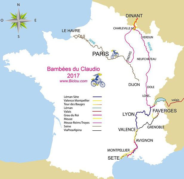
cbandiera.free.fr/...carte-mes-recits.php
bon capo d'anno comme on dit outre alpes
claudio
cbandiera.free.fr/...carte-mes-recits.php
bon capo d'anno comme on dit outre alpes
claudio
Rencontre voyageurs / randonneurs à Aix-les-Bains le vendredi 10 novembre 2017
Bonjour les savoyards et les autres : c'est ouvert à tout les seniors 😏
Vous en avez assez de voyager seul , de randonner seul ou d'abandonner des projets de treks faute de partenaires !!!! 😠.... alors voyageurs baroudeurs trekkeurs, marcheurs seniors au temps libre , rencontrons nous le vendredi 10 novembre à Aix les Bains à partir de 11h30 jusqu'à 18 heures pour déjeuner ou boire un verre ...
Ce sera l'occasion de rencontrer de possibles partenaires de voyages, de randos, de treks, de passer du virtuel au réel, d'échanger des infos et bons plans, de partager des idées , des envies, et de concrétiser quelques beaux projets et surtout de se constituer un groupe de compagnons de voyage à géométrie variable .
Venez avec vos idées , vos projets .....Nous sommes pour l'instant 6 , nous nous arrêterons à 12 pour garder la convivialité , donc bienvenus encore à 6 personnes .
véronique 😏
je n'ai pas encore décidé du lieu , ce sera un café brasserie en centre ville , et si l'un de vous connait un lieu sympa : idée bienvenue 😏
Vous en avez assez de voyager seul , de randonner seul ou d'abandonner des projets de treks faute de partenaires !!!! 😠.... alors voyageurs baroudeurs trekkeurs, marcheurs seniors au temps libre , rencontrons nous le vendredi 10 novembre à Aix les Bains à partir de 11h30 jusqu'à 18 heures pour déjeuner ou boire un verre ...
Ce sera l'occasion de rencontrer de possibles partenaires de voyages, de randos, de treks, de passer du virtuel au réel, d'échanger des infos et bons plans, de partager des idées , des envies, et de concrétiser quelques beaux projets et surtout de se constituer un groupe de compagnons de voyage à géométrie variable .
Venez avec vos idées , vos projets .....Nous sommes pour l'instant 6 , nous nous arrêterons à 12 pour garder la convivialité , donc bienvenus encore à 6 personnes .
véronique 😏
je n'ai pas encore décidé du lieu , ce sera un café brasserie en centre ville , et si l'un de vous connait un lieu sympa : idée bienvenue 😏
Guide pour trek au Tadjikistan
Bonjour,
Nous souhaitons nous rendre au Tadjikistan depuis l’Ouzbékistan. Nous avons 5 jours pour faire un trek et découvrir les lacs et villages du Tajikistan. Est-ce que 5 jours sont suffisant et est-il facile de trouver un guide sur place, à Khodjent ?
Merci d'avance,
Nous souhaitons nous rendre au Tadjikistan depuis l’Ouzbékistan. Nous avons 5 jours pour faire un trek et découvrir les lacs et villages du Tajikistan. Est-ce que 5 jours sont suffisant et est-il facile de trouver un guide sur place, à Khodjent ?
Merci d'avance,