Results for "Hyères+et+hébergement+|+127"
1231 results found.
Routes du sud de la France à vélo English translation pending
Bonjour a tous et a toutes
J'ai comme projet courant avril de partir en vélo de la maison ( prés de la Rochelle ) jusqu’ à Nice , puis faire marche arrière jusqu’à Beaucaire pour attaqué la via Rhôna pour allée a Chambéry .
Jusqu'a Sète je connais pour l'avoir fait il y a 2 ou 3 ans ! Mon interrogation serais plutôt de Séte a Nice les meilleurs routes sans trop de dénivelés ci possible ( je suis assez chargé ) au plus prés de la mer ? évité les grandes agglomérations comme Marseille ! je ne connais pas du tout le sud de la France mais a se que j'ai pu voir sur Map ça ma l'air de grimpé pas mal ! j'ai l'habitude de pédalé mais quand il y a de long voyage comme celui là , si je peut contourné les portions qui grimpe je préfère !
Si quelqu'un peut me donné des conseilles , des infos , c'est avec plaisir que je vous lirez .😛
Ps Elle est sympa cette partie de la via Rhôna Beaucaire Chambéry , pas trop difficile ?
Moins de croisiéristes français pour un secteur cependant à la hausse English translation pending
Bonjour
Pour info, article clair et synthétique.
Cordialement
http://www.quotidiendutourisme.com/croisieres/croisieres-moins-de-passagers-francais-mais-une-vitalite-du-secteur-en-hausse/175468
http://www.quotidiendutourisme.com/croisieres/croisieres-moins-de-passagers-francais-mais-une-vitalite-du-secteur-en-hausse/175468
Voyage d'un jeune couple dans le sud de la France English translation pending
Bonjour j'aurais besoin de votre aide pour planifier mon voyage avec ma copine :)
On est un couple de Parisiens qui ne sommes jamais descendu dans le Sud et on souhaiterait partir dans le sud de la France donc et voir un maximum de choses. En tête j'ai évidemment Nice, Cannes, Saint tropez, Monaco, Hyeres, Frejus mais je suis sur qu'il y a plein d'autre magnifiques endroits a découvrir.
Ce que l'on aimerait c'est se poser quelque part pour ensuite rayonner autour chaque jours dans un endroit différent (Sachant que l'on a une voiture). On aimerait aussi parfois rester sur place et profitez des activités ou de la plages.
J'aimerais avoir des conseils sur l'endroit ou l'on pourrait rester pendant 2 fois 10 jours (10 jours dans un endroit, 10 jours dans un autre?)
Par ailleurs je n'ai absolument aucune idée sur le type de logement ou l'on pourrait rester sachant que l'on dispo d'environ 1500-2000e a nous deux pour 20 jours et que l'on privilegie un studio pour 2 personnes avec cuisine.
D'ou mes questions:
1- Quels sont les bons endroits dans le Sud pour passer des vacances pas trop cher et pouvoir voir un maximum de choses tout en profitant d’activités sportives et de la plage ?
2- Quelle sont les meilleurs solutions pour se loger pas (trop) cher pour 10 jours ? (Location appart sur leboncoin ? résidence de vacances ? bungalow dans un camping ?)
Je vous remercie par avance et j'attends vos suggestions :)
Tony
On est un couple de Parisiens qui ne sommes jamais descendu dans le Sud et on souhaiterait partir dans le sud de la France donc et voir un maximum de choses. En tête j'ai évidemment Nice, Cannes, Saint tropez, Monaco, Hyeres, Frejus mais je suis sur qu'il y a plein d'autre magnifiques endroits a découvrir.
Ce que l'on aimerait c'est se poser quelque part pour ensuite rayonner autour chaque jours dans un endroit différent (Sachant que l'on a une voiture). On aimerait aussi parfois rester sur place et profitez des activités ou de la plages.
J'aimerais avoir des conseils sur l'endroit ou l'on pourrait rester pendant 2 fois 10 jours (10 jours dans un endroit, 10 jours dans un autre?)
Par ailleurs je n'ai absolument aucune idée sur le type de logement ou l'on pourrait rester sachant que l'on dispo d'environ 1500-2000e a nous deux pour 20 jours et que l'on privilegie un studio pour 2 personnes avec cuisine.
D'ou mes questions:
1- Quels sont les bons endroits dans le Sud pour passer des vacances pas trop cher et pouvoir voir un maximum de choses tout en profitant d’activités sportives et de la plage ?
2- Quelle sont les meilleurs solutions pour se loger pas (trop) cher pour 10 jours ? (Location appart sur leboncoin ? résidence de vacances ? bungalow dans un camping ?)
Je vous remercie par avance et j'attends vos suggestions :)
Tony
Habiter sur un voilier à Porquerolles? English translation pending
Y-a-t'il des gens qui ont fait l'expérience d'habiter sur un voilier à Porquerolles?
Merci!!
De Toulouse à Nice en train English translation pending
Bonjour,
Du début mai à la mi-juin 2010, mon conjoint et moi voulons visiter le sud-est de la France à partir de Toulouse, où nous arriverons par avion de Montréal, jusqu'à Nice. Pouvez-vous m'indiquer un site où je peux simuler nos itinéraires avec le coût s'y rapportant ? Existe-t-il des passes permettant de voyager pendant plusieurs semaines d'un lieu à un autre ? Il est possible que nous louions une auto pour une semaine quelque part pour visiter des villages d'arrière-pays.
Merci de tous vos conseils et de toutes vos suggestions.
Sentier du littoral au départ de Toulon (vers Marseille) English translation pending
Bonjour à tous,
Voilà, j'ai une douzaine de jours de congés à partir du 31 octobre. J'envisage de partir de Toulon pour rejoindre Marseille à pied, en itinérant (of course!). D'abord, le sentier du littoral, puis les falaises à partir de La Ciotat et les Calanques. J'ai lu plusieurs posts à ce sujet, mais j'ai tout de même quelques questions avant de m'aventurer seule dans ce (petit, mais tout de même!) périple:
- Le trajet est-il chouette entre Toulon et La Ciotat? (Entre La Ciotat et Marseille, je connais déjà...) - Est-il bien praticable ou y a-t-il beaucoup de portions fermées pour travaux? - L’hébergement est-il possible tout le long? Sachant que je ne souhaite pas porter ma tente, donc je recherche un hébérgement en dur, type gite d'étape... - A cette période, est-ce une bonne idée?
Je précise que je suis sportive et habituée à la marche.
Merci à tous ceux que me fourniront leurs précieux conseils...
🙂
Voilà, j'ai une douzaine de jours de congés à partir du 31 octobre. J'envisage de partir de Toulon pour rejoindre Marseille à pied, en itinérant (of course!). D'abord, le sentier du littoral, puis les falaises à partir de La Ciotat et les Calanques. J'ai lu plusieurs posts à ce sujet, mais j'ai tout de même quelques questions avant de m'aventurer seule dans ce (petit, mais tout de même!) périple:
- Le trajet est-il chouette entre Toulon et La Ciotat? (Entre La Ciotat et Marseille, je connais déjà...) - Est-il bien praticable ou y a-t-il beaucoup de portions fermées pour travaux? - L’hébergement est-il possible tout le long? Sachant que je ne souhaite pas porter ma tente, donc je recherche un hébérgement en dur, type gite d'étape... - A cette période, est-ce une bonne idée?
Je précise que je suis sportive et habituée à la marche.
Merci à tous ceux que me fourniront leurs précieux conseils...
🙂
Voyage sur la Côte d'Azur - Espagne - Allemagne en septembre English translation pending
🙂 Bonjour chers Voyageurs!!
Je suis en train de planifier mon prochain voyage. Je désire obtenir vos conseils et recommandations !
Voici les grandes lignes, en septembre je serai à Marseille. Par la suite, je suivrai la côte vers l'EST pour prendre du soleil et goûter au plaisr de la mer. Des villes ou sites incontournables (entre Marseille et Nice) que je devrais visiter????
Une semaine plus tard, je désire visiter une ou deux villes en Espagne. Si je prends Ryanair, je suis limité pour les vols, ainsi je serai a Madrid (vol Marseille Madrid). Malgré que Marseille et Barcelone semble se faire par voie terrestre. Suggestions entre Madid et Barcelone ??? Vous me suggérez d'éviter les grandes villes pour un moment de détente en bordure de la Méditerranée ??
Si vous me suggérez une ville .... précisez moi où manger, où dormir, où sortir, quoi visitez, votre coup de coeur ??? ;)
Pour des raisons de couts et de localisations, je m'enligne pour dormir aux auberges de la jeunesse........
Apres l'espagne, je m'oriente vers l'Allemagne ...... Là c'est completement l'inconnu .... alors allez s'y avec vos idées!
Merci à vous tous ! :)
Si vous avez des questions sur Montréal ou Quebec, je suis la pour ca! ;)
Je suis en train de planifier mon prochain voyage. Je désire obtenir vos conseils et recommandations !
Voici les grandes lignes, en septembre je serai à Marseille. Par la suite, je suivrai la côte vers l'EST pour prendre du soleil et goûter au plaisr de la mer. Des villes ou sites incontournables (entre Marseille et Nice) que je devrais visiter????
Une semaine plus tard, je désire visiter une ou deux villes en Espagne. Si je prends Ryanair, je suis limité pour les vols, ainsi je serai a Madrid (vol Marseille Madrid). Malgré que Marseille et Barcelone semble se faire par voie terrestre. Suggestions entre Madid et Barcelone ??? Vous me suggérez d'éviter les grandes villes pour un moment de détente en bordure de la Méditerranée ??
Si vous me suggérez une ville .... précisez moi où manger, où dormir, où sortir, quoi visitez, votre coup de coeur ??? ;)
Pour des raisons de couts et de localisations, je m'enligne pour dormir aux auberges de la jeunesse........
Apres l'espagne, je m'oriente vers l'Allemagne ...... Là c'est completement l'inconnu .... alors allez s'y avec vos idées!
Merci à vous tous ! :)
Si vous avez des questions sur Montréal ou Quebec, je suis la pour ca! ;)
Bientôt des sans-abris à Dubaï (fin novembre 2009) English translation pending
Une petite subvention pour Roger Federer et David Beckam peut-être.....?🤪
Dubaï: le mirage s'écroule... Les dirigeants du petit état de Dubaï ont vu grand, avec un sens de l'éthique et d'humanité totalement absent. Une folie des grandeurs sans limite jusqu'à hier lorsque la réalité de l'économie mondiale les a rattrapé. À force de repousser les limites au maximum, le fil a craqué. Les effets se font sentir sur les marchés financiers. Au fait, pourquoi les banques leur ont accordé autant de prêts?
Dubaï: le mirage s'écroule...
Les dirigeants du petit état de Dubaï ont vu grand, avec un sens de l'éthique et d'humanité totalement absent. Une folie des grandeurs sans limite jusqu'à hier lorsque la réalité de l'économie mondiale les a rattrapé. À force de repousser les limites au maximum, le fil a craqué. Les effets se font sentir sur les marchés financiers. Au fait, pourquoi les banques leur ont accordé autant de prêts?
Itinéraire pour le sud de la France en voiture? English translation pending
bonjour, j aimerais avoir des propositions d itineraires pour tout le sud de la france d ouest en est et ce en voiture.
J arriverai le 29 aout et j ai 2 semaines pour ce trajet.
merci d avance!
J arriverai le 29 aout et j ai 2 semaines pour ce trajet.
merci d avance!
Hôtels ou appartements pas chers sur la Côte d'Azur? English translation pending
Bonjour,
nous serons sur la Côte d'azur 2 juillet au 7 juillet (Marseille à Monaco) et nous avons une voiture pour nous déplacer. Nous aimerions éviter de changer d'hôtel à chaque soir car cela nous demande de refaire nos bagages à chaque matin. Nous nous demandons donc s'il est réaliste en terme de coûts d'essence et de distance km de garder la même chambre d'hotel pendant ce 5 jours ou si cela va nous revenir plus cher que de changer d'hôtel à chaque soir. Qu'en pensez-vous?
Par ailleurs, avez-vous des hôtels ou apparetements à nous recommander propres et pas chers.
Merci!
nous serons sur la Côte d'azur 2 juillet au 7 juillet (Marseille à Monaco) et nous avons une voiture pour nous déplacer. Nous aimerions éviter de changer d'hôtel à chaque soir car cela nous demande de refaire nos bagages à chaque matin. Nous nous demandons donc s'il est réaliste en terme de coûts d'essence et de distance km de garder la même chambre d'hotel pendant ce 5 jours ou si cela va nous revenir plus cher que de changer d'hôtel à chaque soir. Qu'en pensez-vous?
Par ailleurs, avez-vous des hôtels ou apparetements à nous recommander propres et pas chers.
Merci!
Accueillons cyclistes en Haute-Savoie English translation pending
Besoin d’une petite halte en Haute-Savoie lors de votre trip à vélo ?
Votre solution : Mumu et Dédé vous accueillent chez eux pour un repas haut savoyard bien sûr et un matelas confortable pour passer une bonne nuit reposante.
C’est gratuit, pas luxueux mais sympa et cela nous permettra de nous faire des contacts pour nos prochains voyages.
Alors allez-y, contactez-nous.
Pour info, anglais et italien parlés !!!!
Conseils pour des vacances dans le Var (France) English translation pending
Bonjour à tous
Je ne connais pas du tout le Var.
Mes prochaines vacances sont pour le mois de septembre et j'ignore encore où je vais pouvoir aller.
J'ai l'habitude (bonne ou mauvaise ?) de choisir au dernier moment et je me demandais si vous pouviez me donner un petit coup de pouce afin que, pour une fois, je commence à faire un un petit tour d'horizon dans des délais raisonnables ?
Le 83 me fait envie ! (ailleurs aussi remarquez et c'est bien pour ça que je me décide au dernier moment à chaque fois !)
Cependant si vous pouviez m'indiquer des destinations sympas (VAR) proches de la mer (accès à pied de préférence ou au pire en vélo mais pas en voiture) afin que je puisse faire un premier tri.
Je souhaiterais un petit village (?) avec pas trop de monde où je pourrais trouver soit un camping soit une location (cheap !)
Est-ce que ça existe ?
Merci d'avance à tous ceux qui prendront du temps pour me répondre.
Sud de la France: où aller? English translation pending
Bonjour à tous,
Je suis une étudiante de 21 ans et je voyage seule. Mon avion arrive à Paris à la mi-mai et j'ai à peu près un mois à passer en France. Sans m'étaler sur de grandes distances, je préfére visiter une région à fond: j'ai donc choisi le sud de la France.
Sans nécessairement rechercher les grandes villes, j'aimerais plutôt découvrir les petits coins qui sont aussi beaux (sinon plus!). Je pense qu'en un mois je devrais avoir le temps de faire tout le sud, de l'est à l'ouest: mais où m'arrêter, quels villages sont à ne pas manquer? De plus, étant étudiante à temps plein, je n'ai pas d'argent, sinon juste assez pour survivre (eau, baguette et auberge de jeunesse miteuse!). Je suis à la recherche de conseils, suggestions et autres informations sur la région et la meilleure façon de m'y déplacer (j'imagine l'autobus comme étant la meilleure solution.) Merci à l'avance.
Dorothée
Je suis une étudiante de 21 ans et je voyage seule. Mon avion arrive à Paris à la mi-mai et j'ai à peu près un mois à passer en France. Sans m'étaler sur de grandes distances, je préfére visiter une région à fond: j'ai donc choisi le sud de la France.
Sans nécessairement rechercher les grandes villes, j'aimerais plutôt découvrir les petits coins qui sont aussi beaux (sinon plus!). Je pense qu'en un mois je devrais avoir le temps de faire tout le sud, de l'est à l'ouest: mais où m'arrêter, quels villages sont à ne pas manquer? De plus, étant étudiante à temps plein, je n'ai pas d'argent, sinon juste assez pour survivre (eau, baguette et auberge de jeunesse miteuse!). Je suis à la recherche de conseils, suggestions et autres informations sur la région et la meilleure façon de m'y déplacer (j'imagine l'autobus comme étant la meilleure solution.) Merci à l'avance.
Dorothée
France: quelle destination choisir en août? English translation pending
Bonjour,
Nous sommes un couple avec un petit garçon de 2 ans. J'ai passé mon enfance et mon adolescence en camping car. Puis avec mon Amoureux qui deviendra mon époux et le papa de mon petit garçon, nous avons fait du camping itinérant en tente. L'année passée, j'ai redécouvert les joies du camping-car en Bretagne. Nous avons pas mal visité, je suis une maman Koala et à l'époque notre petit mec se trouvait très souvent sur mon dos! Nous pensons que cette année, nous devons trouver un juste milieu pour que lui aussi puisse prendre du plaisir. Nous pensions peut-être à Lacanau, la dune du Pyla, ... Mais nous ne connaissons pas l'accueil réservé aux c-cars dans cette région. Toutes les propositions sont les bienvenues, nous aimons beaucoup le vélo nous avons un Croozer (remorque pour enfants) pour y installer notre petit mec, nous aimons aussi pouvoir nous détendre et profiter, nous aimons bien manger. Déjà merci de votre attention et de vos commentaires. Belle soirée.
Nous sommes un couple avec un petit garçon de 2 ans. J'ai passé mon enfance et mon adolescence en camping car. Puis avec mon Amoureux qui deviendra mon époux et le papa de mon petit garçon, nous avons fait du camping itinérant en tente. L'année passée, j'ai redécouvert les joies du camping-car en Bretagne. Nous avons pas mal visité, je suis une maman Koala et à l'époque notre petit mec se trouvait très souvent sur mon dos! Nous pensons que cette année, nous devons trouver un juste milieu pour que lui aussi puisse prendre du plaisir. Nous pensions peut-être à Lacanau, la dune du Pyla, ... Mais nous ne connaissons pas l'accueil réservé aux c-cars dans cette région. Toutes les propositions sont les bienvenues, nous aimons beaucoup le vélo nous avons un Croozer (remorque pour enfants) pour y installer notre petit mec, nous aimons aussi pouvoir nous détendre et profiter, nous aimons bien manger. Déjà merci de votre attention et de vos commentaires. Belle soirée.
RoadTrip Marseille/Nice à vélo English translation pending
Salut tout le monde!
Voila, je me présente en même temps, je m'appels Antoine, 22 ans. Je suis francais, originaire de l'Hérault et vis présentement au Canada, plus précisement a Montréal, au Quebec. J'ai une grande passion pour les voyages!
Je compte passer l'été prochain chez moi, dans le sud de la France, et aimerai bien découvrir ces magnifiques paysage que finalement, je ne connais pas...
J'aimerais vous expliquez mon projet, et savoir si c'est réalisable comme je le pense. Tout d’abord, mon moyen de locomotion sera à vélo. Habitant à Sète, je compte prendre le train direction Marseille pour la première étape. Arrivée a Nice 6 jours plus tard, pour prendre le bateau direction Bastia, en Corse.
JOUR 1 - Départ Marseille -> La Ciotat -> Bandol (49,1KM)
Une fois débarquer a Marseille, j'enfourche mon vélo direction Bandol ou je passerai ma première nuit (itinéraire de 49,1KM) ! Je sais que la grosse partie entre Marseille et La Ciotat ce passe dans les montagnes, avec certainement des cotes ! (savez vous ci se chemin est vraiment difficile sachant que je n'ai pas vraiment une grande expérience dans le vélo?)
Voici l'itinéraire google map

JOUR 2 Bandol -> Toulon -> Hyères -> La Londe les maures (42,5KM)
On part de Bandol pour rejoindre La Londe Les Maures à 42,5 km de la. (Y a t'il des pièges sur ce chemin? Du genre, difficulté de roulé a vélo? Relief?)
Voici l'itinéraire google map

JOUR 3 La Londe les maures -> Saint Tropez (46,2KM)
Je compte bien me relaxé un peu sur les plages de St Trop' ! (Est ce une bonne idée de longé le littoral? ou vaudrai mieux passer par les terres?)
Voici l'itinéraire google map

JOUR 4 Saint Tropez -> Saint Raphael (35,1KM)
Voici l'itinéraire google map

JOUR 5 Saint Raphael -> Cannes (49,9KM)
Voici l'itinéraire google map

JOUR 6 Cannes -> Nice (30,1KM)
Voici l'itinéraire google map

J'ai choisi de faire ce voyage en 6 jours, avec de courtes distances a parcourir chaque jour. En moyenne 45KM par jour (ce qui correspond a quoi? 4H de vélo par jour?)
Une fois arrivée a Nice, embarquement sur le bateau pour la Corse!
J'ai commencé a regarder pour les hébergements, je serai équipé d'une tente (Possibilité de faire du camping sauvage dans cette région?), donc loué un emplacement pour 1 nuit, sans voiture, doit pas couté plus chère que 15€ non?
Dites moi ce que vous pensez de ce parcourt, vos avis, conseils, impressions sont les bienvenues! Je compte partir en Juin, avant les touristes et les grosses chaleurs! Pour le moment seul, mais d'ici la, peut être que ce voyage va plaire a un de mes amis, et m'accompagnera :)
Je vous remercie d'avance! Et à très bientôt
Antoine G.

Voila, je me présente en même temps, je m'appels Antoine, 22 ans. Je suis francais, originaire de l'Hérault et vis présentement au Canada, plus précisement a Montréal, au Quebec. J'ai une grande passion pour les voyages!
Je compte passer l'été prochain chez moi, dans le sud de la France, et aimerai bien découvrir ces magnifiques paysage que finalement, je ne connais pas...
J'aimerais vous expliquez mon projet, et savoir si c'est réalisable comme je le pense. Tout d’abord, mon moyen de locomotion sera à vélo. Habitant à Sète, je compte prendre le train direction Marseille pour la première étape. Arrivée a Nice 6 jours plus tard, pour prendre le bateau direction Bastia, en Corse.
JOUR 1 - Départ Marseille -> La Ciotat -> Bandol (49,1KM)
Une fois débarquer a Marseille, j'enfourche mon vélo direction Bandol ou je passerai ma première nuit (itinéraire de 49,1KM) ! Je sais que la grosse partie entre Marseille et La Ciotat ce passe dans les montagnes, avec certainement des cotes ! (savez vous ci se chemin est vraiment difficile sachant que je n'ai pas vraiment une grande expérience dans le vélo?)
Voici l'itinéraire google map
JOUR 2 Bandol -> Toulon -> Hyères -> La Londe les maures (42,5KM)
On part de Bandol pour rejoindre La Londe Les Maures à 42,5 km de la. (Y a t'il des pièges sur ce chemin? Du genre, difficulté de roulé a vélo? Relief?)
Voici l'itinéraire google map
JOUR 3 La Londe les maures -> Saint Tropez (46,2KM)
Je compte bien me relaxé un peu sur les plages de St Trop' ! (Est ce une bonne idée de longé le littoral? ou vaudrai mieux passer par les terres?)
Voici l'itinéraire google map
JOUR 4 Saint Tropez -> Saint Raphael (35,1KM)
Voici l'itinéraire google map
JOUR 5 Saint Raphael -> Cannes (49,9KM)
Voici l'itinéraire google map
JOUR 6 Cannes -> Nice (30,1KM)
Voici l'itinéraire google map
J'ai choisi de faire ce voyage en 6 jours, avec de courtes distances a parcourir chaque jour. En moyenne 45KM par jour (ce qui correspond a quoi? 4H de vélo par jour?)
Une fois arrivée a Nice, embarquement sur le bateau pour la Corse!
J'ai commencé a regarder pour les hébergements, je serai équipé d'une tente (Possibilité de faire du camping sauvage dans cette région?), donc loué un emplacement pour 1 nuit, sans voiture, doit pas couté plus chère que 15€ non?
Dites moi ce que vous pensez de ce parcourt, vos avis, conseils, impressions sont les bienvenues! Je compte partir en Juin, avant les touristes et les grosses chaleurs! Pour le moment seul, mais d'ici la, peut être que ce voyage va plaire a un de mes amis, et m'accompagnera :)
Je vous remercie d'avance! Et à très bientôt
Antoine G.
Destination pour une semaine à deux avec un budget 400€ strict? English translation pending
Bonjour,
Je souhaite partir avec mon mari pour 1 petite semaine n'importe ou à l'etranger sauf en afrique du nord on l'a deja fait et refait, le top serait chypre malte ou la grece ou sur les iles greque (la crete m'attire bien ) mais notre budget est super serré on viens d'avoir un ti boutchou et on a besoin de soufflé un peu pour revenir en pleine forme en septembre . Sachant que je suis étudiante c'est pas évident on sera libre en juillet et en septembre !!! Donc voila. SVP donner nous tous vos bon plans on hesite a prendre le petit avec nous il a 10 mois donc... ca reste à voir. On aime beaucoup la nature les beaux oaysage la mer... Bref voila etre limité par l'argent c'est pas le top mais on a trop envie de partir. Donner nous toutes vos experience de voyage et ts vos bon plan . On a trouver un deal pour 150€ 4 nuits en crete a agios nikolaos a 60km d heraklion je sais pas du tout si ca vaux le coup merci de me repondre au plus tot .
😉
Est ce que c'est possible avec 400€????
Je souhaite partir avec mon mari pour 1 petite semaine n'importe ou à l'etranger sauf en afrique du nord on l'a deja fait et refait, le top serait chypre malte ou la grece ou sur les iles greque (la crete m'attire bien ) mais notre budget est super serré on viens d'avoir un ti boutchou et on a besoin de soufflé un peu pour revenir en pleine forme en septembre . Sachant que je suis étudiante c'est pas évident on sera libre en juillet et en septembre !!! Donc voila. SVP donner nous tous vos bon plans on hesite a prendre le petit avec nous il a 10 mois donc... ca reste à voir. On aime beaucoup la nature les beaux oaysage la mer... Bref voila etre limité par l'argent c'est pas le top mais on a trop envie de partir. Donner nous toutes vos experience de voyage et ts vos bon plan . On a trouver un deal pour 150€ 4 nuits en crete a agios nikolaos a 60km d heraklion je sais pas du tout si ca vaux le coup merci de me repondre au plus tot .
😉
Est ce que c'est possible avec 400€????
Trajet Marseille-Aix-en-Provence, itinéraire en Provence-Côte d'Azur? English translation pending
Nous irons en Provence à l'automne (2 personnes). Nous atterrisons à Marseille - quelles sont les façons de se rendre à Aix-en-Provence ou quelle
est la meilleure façon de s'y rendre ? Quels sont les endroits à ne pas manquer ou que vous recommandez ainsi que des conseils pour un itinéraire
intéressant ? Nous pensons séjourner à Aix et rayonner à partir de là (4 semaines) et également vers la Côte d'Azur, Monaco etc.
Nous logerons dans des Gites.
Merci à l'avance de vos précieux conseils.
Cabotine
Iinéraire pour deux ou trois semaines en France English translation pending
Bonjour je suis nouvelle 🙂
Nous planifions un voyage en France pour 2 ou 3 semaines en juin prochain....
Bon... j'étudie par dessus la tête...
J'étudie les cartes, visite les nombreux sites internet qui parlent de voyages.... me suis achetée les guides du routard de la Provence et celui de la Côte d'Azur mais... plus je lis....plus j'ai des questions
Premièrement, nous nous cherchons un itinéraire
Deuxièmement, nous ne sommes pas trop chauds à l'idée de louer une voiture car la conduite est, paraîtrait-il, très différente de la nôtre ainsi que les routes, surtout dans les grosses villes et c'est là que se trouvent les aéroports...
Mais... si nous ne louons pas une voiture, serons-nous confinés seulement dans les grandes villes? Je sais qu'il y a les TGV... c'est une avenue que je vais explorer...
Serions-nous mieux de choisir 2 villes où il y a un aéroport, se déplacer en car ou à pieds et afin de pouvoir visiter entre les deux, se louer une voiture?
Ah... autre point.... se peut-il que les restos et bistrots soient beaucoup plus dispendieux en Provence et sur la Côte d'Azur qu'au Québec?... Mes références viennent du guide du routard...
Vos commentaires et expériences me seraient d'un grand secours...
Je parles de Provence et Côte d'Azur mais si mon budget ne me permet pas ces destinations, je suis prête à visiter tout pays de l'Europe...
Je ne connais rien, mais rien du tout, au delà de la grande mare...
Que me suggérez-vous? Tout sera en fonction de l'itinéraire...
Ah... oui pour l'hébergement, est-ce vraiment mieux de tout réserver à l'avance, à la journée près ou est-ce facile, rendus sur place, de trouver des hébergements à la dernière minute. Nous désirons voyager en chambres d'hôtes, ce qui est l'équivalent ici du bed and breakfast... Pour nous, les contacts avec les gens sont importants et rassurants...compte tenu que nous sommes néophytes...
Ouf que de questions (gênée)
Merci de vos réponses
Nous planifions un voyage en France pour 2 ou 3 semaines en juin prochain....
Bon... j'étudie par dessus la tête...
J'étudie les cartes, visite les nombreux sites internet qui parlent de voyages.... me suis achetée les guides du routard de la Provence et celui de la Côte d'Azur mais... plus je lis....plus j'ai des questions
Premièrement, nous nous cherchons un itinéraire
Deuxièmement, nous ne sommes pas trop chauds à l'idée de louer une voiture car la conduite est, paraîtrait-il, très différente de la nôtre ainsi que les routes, surtout dans les grosses villes et c'est là que se trouvent les aéroports...
Mais... si nous ne louons pas une voiture, serons-nous confinés seulement dans les grandes villes? Je sais qu'il y a les TGV... c'est une avenue que je vais explorer...
Serions-nous mieux de choisir 2 villes où il y a un aéroport, se déplacer en car ou à pieds et afin de pouvoir visiter entre les deux, se louer une voiture?
Ah... autre point.... se peut-il que les restos et bistrots soient beaucoup plus dispendieux en Provence et sur la Côte d'Azur qu'au Québec?... Mes références viennent du guide du routard...
Vos commentaires et expériences me seraient d'un grand secours...
Je parles de Provence et Côte d'Azur mais si mon budget ne me permet pas ces destinations, je suis prête à visiter tout pays de l'Europe...
Je ne connais rien, mais rien du tout, au delà de la grande mare...
Que me suggérez-vous? Tout sera en fonction de l'itinéraire...
Ah... oui pour l'hébergement, est-ce vraiment mieux de tout réserver à l'avance, à la journée près ou est-ce facile, rendus sur place, de trouver des hébergements à la dernière minute. Nous désirons voyager en chambres d'hôtes, ce qui est l'équivalent ici du bed and breakfast... Pour nous, les contacts avec les gens sont importants et rassurants...compte tenu que nous sommes néophytes...
Ouf que de questions (gênée)
Merci de vos réponses
Les interdits à travers le monde English translation pending
Salut,
Bon je ne savais pas trop ou placer ce post, donc je pense qu'il sera mis à la bonne place incessamment sous peu!😉
J'avais lancé une discussion sur les visas en vue de mon tour du monde, et on en est arrivés à quelques interdit que l'on pourrait trouver à droite à gauche!
Genre, interdit de camper en birmanie, interdit d'heberger un etranger au vietnam, interdit de faire du stop en australie etc etc!
Connaissez vous des interdits utiles pour les voyageurs que l'on peut trouver dans le monde!
Merci
A plus
Idée randonnées dans le sud de la France English translation pending
Bonjour,
je cherche des idées de randonnée d'une semaine dans le sud (début mai) , si possible le long du littoral, un peu comme le sentier des douaniers en bretagne mais dans le Sud! Avec toujours la mer en vue.. J'ai bien vu qu'il y avait un sentier littoral mais jamais en discontinue..
Si vous avez des idées, des commentaires... Merci!
je cherche des idées de randonnée d'une semaine dans le sud (début mai) , si possible le long du littoral, un peu comme le sentier des douaniers en bretagne mais dans le Sud! Avec toujours la mer en vue.. J'ai bien vu qu'il y avait un sentier littoral mais jamais en discontinue..
Si vous avez des idées, des commentaires... Merci!
Août en Provence = cauchemar? English translation pending
Bonjour, J'ai besoin d'être sécurisé...aidez-moi ! À lire les discussions sur le site, j'ai l'impression que mon voyage que j'ai planifié en Provene et Cote d'azur en aout 2011 sera un cauchemar; tempéraure trop chaude, embouteillages monstres partour, plages bondées de touristes, etc...Est-ce si pire ? et si oui, comment en tirer le meilleur ?😕
Nous serons 4 (adultes et 2 grand ados) qui aurons un pied à terre à Avigon et une voiture pour se promener...Vos conseils et discours sécurisants sont les bienvenus.🙂
Nous serons 4 (adultes et 2 grand ados) qui aurons un pied à terre à Avigon et une voiture pour se promener...Vos conseils et discours sécurisants sont les bienvenus.🙂
Croisière Tour du Monde MSC 2020, on le prépare? English translation pending
Inscrits pour TDM 2020 MSC.
Passerons l'hiver 2019 , aux Antilles , chez notre fille .
Nous aurons quelques temps morts pour " étudier et organiser "nos differentes escales .
Nous privilégierons une organisation personnelle ( pour des raisons certainement partagées - ) - mobilité ( attendre que 4 bus soient pleins pour démarrer .....non , merci ) et pécuniaires .
Ce qui va nécessiter une recherche importante : ( et interessante !!!)
- quai d'accueil éloigné du centre ville ? Station de taxis ( ou loc. de voitures proches - prix approximatif -) les " incontournables "de l'escale -.........
Il serait peut être utile de former un petit groupe partageant les mêmes objectifs et qui pourrait s'associer , pour ce travail de recherche , et , ensuite en faire une diffusion ( limitée aux personnes qui se seront engagées)à une date donnée .
Il est evident qu'ensuite , il y aura une petite " adaptation personnelle " à y ajouter .
Voilà , premier jet de ce que j'entrevois .
Certainement à perfectionner et compléter .
Ce n'est pas exhaustif ...
L'île de Pâques et Ushuaia ne peuvent pas , à mon avis se faire correctement , sans une bonne préparation .
Voilà , ne me jugez pas , comme un psycho rigide , j'aime seulement le travail bien fait MAIS AUSSI , partager , dire des bêtiseset en rire !!
Merci pour vos retours .
Anne marie et Jean louis VALENTIN
Meilleure période pour la Norvège en camping-car? English translation pending
Bjr,
Je découvre ce forum,
Je projette un séjour vers le cap Nord avec mon CC profilé, je recherche les incontournables et surtout les meilleurs conseils pour découvrir ce pays, en particulier la meilleure saison.
( les bons plans sont bienvenus : pour s'y rendre, sites insolites à découvrir, ce qu'il faut éviter...mais aussi ce qu'il ne faut pas rater)
Merci à vous,
Durée du voyage souple en fonction des éléments recueillis ( entre 3 et 5 semaines)
Et de grâce les donneurs de leçons sont dispensés de répondre... ceux qui ne veulent pas aider prétextant que tout a déjà été dit... je n'attends que les réponses des passionnés du pays capables de me donner envie ! JMP3
Et de grâce les donneurs de leçons sont dispensés de répondre... ceux qui ne veulent pas aider prétextant que tout a déjà été dit... je n'attends que les réponses des passionnés du pays capables de me donner envie ! JMP3
Début du tour de France à pied English translation pending
Bonjour,
j'envisage de faire le tour de France à Pied - sur plusieurs périodes - en commençant pas les côtes. Je suis en Bretagne, j'ai donc pas mal marché le long de ces côtes.Je fais en moyenne 10 à 15 kilomètres de marche tous les jours ( à un peu plus de 6kmh : beaucoup de plat tout de même)
Donc je vais découper ce tour selon mes vacances:et je vais commencer en mai,8 à 9 jours de marche : 30 à 35 km par jour Voici le détail: 1 - frontière Italienne - Beaulieu sur Mer 2- Beaulieu - Villeneuve Loubet 3- Villeneuve- Cannes 4- Cannes - Saint Raphael (camping du Agay soleil) 5- Saint Rapahel - Sainte Maxime (camping les cigalons) 6- Saint Maxime - Ramatuelle 7- Ramatuelle - le Lavandou 8- Le Lavandou - La londe des maures 9- la londe - Hyeres
En fait , je ne connais que très peu cette région et j'ai 2 grosses questions: 1/ le denivelé est-il très important dans les zones de calanques 2/ Sur les routes de bords de mer, y a t-il toujours un accès piéton, surtout dans les zones hors agglomérations.
Sinon, je suis ouverts à toutes remarques ou question.
Merci de votre lecture
Bertrand
j'envisage de faire le tour de France à Pied - sur plusieurs périodes - en commençant pas les côtes. Je suis en Bretagne, j'ai donc pas mal marché le long de ces côtes.Je fais en moyenne 10 à 15 kilomètres de marche tous les jours ( à un peu plus de 6kmh : beaucoup de plat tout de même)
Donc je vais découper ce tour selon mes vacances:et je vais commencer en mai,8 à 9 jours de marche : 30 à 35 km par jour Voici le détail: 1 - frontière Italienne - Beaulieu sur Mer 2- Beaulieu - Villeneuve Loubet 3- Villeneuve- Cannes 4- Cannes - Saint Raphael (camping du Agay soleil) 5- Saint Rapahel - Sainte Maxime (camping les cigalons) 6- Saint Maxime - Ramatuelle 7- Ramatuelle - le Lavandou 8- Le Lavandou - La londe des maures 9- la londe - Hyeres
En fait , je ne connais que très peu cette région et j'ai 2 grosses questions: 1/ le denivelé est-il très important dans les zones de calanques 2/ Sur les routes de bords de mer, y a t-il toujours un accès piéton, surtout dans les zones hors agglomérations.
Sinon, je suis ouverts à toutes remarques ou question.
Merci de votre lecture
Bertrand
GR20 en Corse en juillet 2013: recherche de partenaires ou randonnée guidée? English translation pending
Bonjour,
Pour différentes raisons, je songe finalement à laisser tomber l'Asie pour me tourner vers la Corse en juillet. Randonneuse d'expérience, j'aimerais bien relever le défi que propose le GR20. Je suis flexible quant aux dates de départ en juillet. Toutefois, je ne suis pas prête à m'y lancer seule. Par ailleurs, une amie l'a fait l'an dernier, Sud-> Nord (75%), et m'a confié que le sac trop lourd avait été un grand obstacle. Ses genoux ont finalement lâché, raison pour laquelle elle a abandonné.
Un peu dernière minute pour trouver un ou des partenaires (mais peut-être n'est-il pas trop tard?), j'explore d'autres avenues possibles. J'ai lu que la compagnie Corsica-Aventure était la référence dans les offres... xxx Est-ce vrai? Est-ce que ça vaut la peine?
Merci!
Petitebulle1
Pour différentes raisons, je songe finalement à laisser tomber l'Asie pour me tourner vers la Corse en juillet. Randonneuse d'expérience, j'aimerais bien relever le défi que propose le GR20. Je suis flexible quant aux dates de départ en juillet. Toutefois, je ne suis pas prête à m'y lancer seule. Par ailleurs, une amie l'a fait l'an dernier, Sud-> Nord (75%), et m'a confié que le sac trop lourd avait été un grand obstacle. Ses genoux ont finalement lâché, raison pour laquelle elle a abandonné.
Un peu dernière minute pour trouver un ou des partenaires (mais peut-être n'est-il pas trop tard?), j'explore d'autres avenues possibles. J'ai lu que la compagnie Corsica-Aventure était la référence dans les offres... xxx Est-ce vrai? Est-ce que ça vaut la peine?
Merci!
Petitebulle1
Mon deuxième voyage en Thaïlande English translation pending
Salut à tous, je suis nouveau ici, j'aimerais quelques renseignement ou tuyaux si possible, je suis allez en thailande dernièrement, c'était mon tout premier voyage de ma vie, j'ai passé 3 semaines a Bangkok, j'ai vraiment adoré le rythme de vie, c'était la ville mais il y avait des tonnes de chose a faire et a découvrir j'ai passé un très bon moment. Pour le mois d'Avril, disonsentre le 10 et 15, j'ai l'intention de me rendre sur Phuket.
Pour mon premier voyage j'avais pris la compagnie Thai airways car comme je l'ai dis, je n'ai aucune expérience et le voyage direct m'enlevais une grosse part de stress (mon principal stress est de rester coincé dans un pays parce que j'ai raté mon avion au changement)...
Du coup la j'ai regardé pour des vol directs vers Phuket, et surprise je n'en trouve aucun 😕
Je suis de Toulon, j'aimerais savoir d'après vous quel serait la manière la plus économique et SURTOUT la plus pratique et la plus simple d'aller sur Phuket en Avril, quel compagnie choisir etc je sais que j'ai la possibilité de m'arrêter à l'aéroport de Bangkok et ensuite de prendre un autre avion pour aller sur Phuket mais l'aéroport de BKK c'est limite une ville, pour mon premier voyage quelqu'un m'attendait dans cette aéroport mais la cette personne m'attendra à Phuket je vais me retrouver seul dans ce big aéroport a chercher mon avion pour aller a Phuket je ne sais pas si c'est la meilleure solution pour moi...
Voilà quelqu'un aurais une idée ?
merci pour votre aide !
PS : J'aimerais savoir aussi quel est le meilleur endroit pour acheter les billets, j'avais pris sur OPODO les premiers, je n'ai pas rencontré de soucis particulier mais c'est juste qu'ils sont totalement injoignable et quand ont arrive par miracle a avoir quelqu'un au bout du file, la personne dit qu'elle va vous rappeler dans 30min mais ne rappel jamais (ça m'est arrivé deux fois)...
Pour mon premier voyage j'avais pris la compagnie Thai airways car comme je l'ai dis, je n'ai aucune expérience et le voyage direct m'enlevais une grosse part de stress (mon principal stress est de rester coincé dans un pays parce que j'ai raté mon avion au changement)...
Du coup la j'ai regardé pour des vol directs vers Phuket, et surprise je n'en trouve aucun 😕
Je suis de Toulon, j'aimerais savoir d'après vous quel serait la manière la plus économique et SURTOUT la plus pratique et la plus simple d'aller sur Phuket en Avril, quel compagnie choisir etc je sais que j'ai la possibilité de m'arrêter à l'aéroport de Bangkok et ensuite de prendre un autre avion pour aller sur Phuket mais l'aéroport de BKK c'est limite une ville, pour mon premier voyage quelqu'un m'attendait dans cette aéroport mais la cette personne m'attendra à Phuket je vais me retrouver seul dans ce big aéroport a chercher mon avion pour aller a Phuket je ne sais pas si c'est la meilleure solution pour moi...
Voilà quelqu'un aurais une idée ?
merci pour votre aide !
PS : J'aimerais savoir aussi quel est le meilleur endroit pour acheter les billets, j'avais pris sur OPODO les premiers, je n'ai pas rencontré de soucis particulier mais c'est juste qu'ils sont totalement injoignable et quand ont arrive par miracle a avoir quelqu'un au bout du file, la personne dit qu'elle va vous rappeler dans 30min mais ne rappel jamais (ça m'est arrivé deux fois)...
Voyager hors de Paris, les villes les moins chères? English translation pending
Bonjour! :)
Nous sommes 4 (moi incluse) à vouloir voyager, a la mi-juillet (2012 :)), pendant 1 semaine maximum (6 nuits), hors de notre capitale, Paris. Cependant nous ne savons pas où se rendre, avec un budget de moins de 400 euros par personnes (billets, hébergement, restauration)... Il y aurait des villes peu chère en France où l'on pourrait se rendre pendant ces 1 semaine? Par choix, nous ne voulons pas de la plage. Par contre ce qui pourrait seulement nous intéresser, ça serait les musées et les promenades... Un petit voyage culturelle en gros! Merci à vous de me donner plein d'indice pour notre destination! :)
Bonne journée à vous et merci d'avance.
Cordialement, Melle Y.Anita.
Nous sommes 4 (moi incluse) à vouloir voyager, a la mi-juillet (2012 :)), pendant 1 semaine maximum (6 nuits), hors de notre capitale, Paris. Cependant nous ne savons pas où se rendre, avec un budget de moins de 400 euros par personnes (billets, hébergement, restauration)... Il y aurait des villes peu chère en France où l'on pourrait se rendre pendant ces 1 semaine? Par choix, nous ne voulons pas de la plage. Par contre ce qui pourrait seulement nous intéresser, ça serait les musées et les promenades... Un petit voyage culturelle en gros! Merci à vous de me donner plein d'indice pour notre destination! :)
Bonne journée à vous et merci d'avance.
Cordialement, Melle Y.Anita.
Toulon du 18 au 26 juillet: période chargée au niveau touristique? English translation pending
Bonjour,
Je me rend à Toulon du 18 au 26 juillet 😎. Je sais que c'est une période chargée au niveau touristique sur la côte d'azur mais je ne peux pas y aller à un autre moment hélas 🤪. Premièrement est-que c'est vraiment ce qu'on dit : des embouteillages, des plages bondées de monde et des bouchons sur les sentiers de rando ?
Dans ce cas pourriez-vous me conseiller (si il en existe encore !) des endroits à l'écart de l'agitation touristique dans les environs ? J'aime faire de la randonnée (au calme), du vélo, faire de la plongée (avec palmes et tuba !), découvrir des petites îles et des criques sauvages (accessibles uniquement à pied par exemple).
Merci d'avance pour les tuyaux que vous pourrez me donner !
Ciao ciao A+
Je me rend à Toulon du 18 au 26 juillet 😎. Je sais que c'est une période chargée au niveau touristique sur la côte d'azur mais je ne peux pas y aller à un autre moment hélas 🤪. Premièrement est-que c'est vraiment ce qu'on dit : des embouteillages, des plages bondées de monde et des bouchons sur les sentiers de rando ?
Dans ce cas pourriez-vous me conseiller (si il en existe encore !) des endroits à l'écart de l'agitation touristique dans les environs ? J'aime faire de la randonnée (au calme), du vélo, faire de la plongée (avec palmes et tuba !), découvrir des petites îles et des criques sauvages (accessibles uniquement à pied par exemple).
Merci d'avance pour les tuyaux que vous pourrez me donner !
Ciao ciao A+
Mauritanie pratique 2019 English translation pending
MAURITANIE PRATIQUE 2019
PARTIE I
Un mot sur la zone rouge... ou plutôt... bleu blanc sable
Depuis que l'AQMI jusqu'en 2012, puis Boko Haram se sont invités dans la région, et en particulier au Mali, qui partage une très longue frontière avec la Mauritanie sur 2237 km (ah oui quand même!); et y visent des intérêts occidentaux; les conseils aux voyageurs émis par le Quai d'Orsay concernant la Mauritanie sont plutôt alarmistes et décourageants. Mais il faut le dire, les infos fournies ont une facheuse tendance à ne pas être à jour (ce que j'avais déjà eu l'occasion de remarquer pour d'autres destinations comme le Mozambique par exemple). En particulier, les cartes disponibles sur le site France-Diplomatie; qui affichent en rouge les zones formellement déconseillées, en orange les zones déconseillées sauf raison impérative, et en blanc les zones en vigilance renforcée; sont globalement assez dissuasives pour toute visite dans un pays africain et peuvent même faire un peu peur. Je cherche encore un pays avec une zone verte (vigilance normale). Même São-Tomé et Principe; qui est on ne peut plus tranquille, apparaît en zone blanche (vigilance renforcée!)... c'est dire !
Bref, pour mieux cerner la réalité du danger, il n'est pas inopportun de comparer avec les cartes publiées par d'autres chancelleries, et de faire une synthèse des infos.
Ceci étant, même avec un certain retard et un alarmisme toujours excessif, les cartes évoluent... Voir, pour comparaison, les cartes publiées respectivement en décembre 2018 / janvier 2019 puis mars 2019 par le même service (France-Diplomatie via leurs conseils aux voyageurs par pays) Et quand bien même ces quelques critiques sur la tardive mise à jour des informations diffusées, ce site reste bien utile. Une variable à ne pas négliger parmi les multiples paramètres qui définissent "l'évolution de la menace": à l'approche des élections présidentielles dans un pays, une vigilance toute particulière est à considérer.
A savoir...
A l'instar du Mali, la Mauritanie est une ancienne colonie française (de 1902 à 1960) mais elle s'est affranchie du Franc Cfa. Elle possède sa monnaie propre qui est l'ouguiya. (en janvier 2019, 1 euro équivalait plus ou moins à 40 ouguiyas). Il faut retenir que les ouguiyas ont changé de valeur en 2018. Beaucoup de gens -surtout les personnes agées mais pas que- comptent encore en anciens ouguiyas. Il faut s'assurer, quand un prix est annoncé, qu'il l'est bien en nouveaux ouguiyas (qui s'écrivent officiellement num en abrégé, pour les transactions financières mais souvent aussi MRU) et non pas en anciens ouguiyas (qui s'écrivent MRO en abrégé).
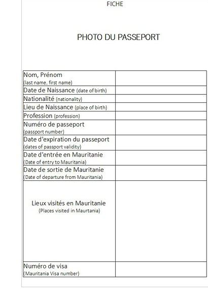
Le français est toujours la langue administrative, assez largement utilisée, alors que la langue officielle est l'arabe. Mais la langue courante, populaire, et la plus couramment parlée, est l'hassanya (considéré comme un dialecte arabe, enrichi de diverses influences linguistiques). A noter que la Mauritanie est la seule république islamique d'Afrique. Ce qui implique, pour les femmes, un code de conduite particuler, et le port du voile. Dans les transports en commun, où hommes et femmes non mariés (ou sans lien de parenté) ne sont pas censément autorisés à s'asseoir côte à côte, cela donne lieu à un minutieux casse-tête pour l'attribution des sièges, avec ré-agencement à chaque fois qu'une ou plusieurs femmes supplémentaires montent (ou descendent). Les occidentaux seront autorisés à s'asseoir entre eux comme bon leur semble, étant attendu qu'ils se plient aux usages vis-à vis des locaux. Dans le même ordre d'idée vous remarquerez sans doute que nombre d'hommes ne serrent jamais la main des femmes (en tous cas, pas en public). Pour circuler dans le pays; que ce soit en transports publics ou avec son propre véhicule (pour les voyages organisés; j'ignore quelle est la règle) ; il faut se préparer à fournir une fiche à chaque checkpoint pour ne pas avoir à montrer son passeport à chaque fois. C'est beaucoup plus simple et rapide (et ça soulage tout le monde, le chauffeur comme les autres passagers; qui doivent sinon attendre la fin des formalités). Difficile de prévoir le nombre de fiches necessaires (qui dépend de l'itinéraire de chaque voyageur sur le territoire) mais pour donner une idée, avec une trentaine de photocopies; j'ai été tranquille pour l'intégralité de mon séjour. Pour ce qui est du contenu, voir l'image en fichier attaché qui donne un exemple de fiche. Dans la rubrique "lieux visités en Mauritanie", bien indiquer tous les lieux où vous souhaitez vous rendre. Et laisser un espace en bas pour inscrire le numéro du visa octroyé à l'arrivée. Hors des sentiers battus - si tant est que l'on puisse parler de sentiers battus en Mauritanie- un gendarme zélé peut très bien vous faire remarquer que le village où vous entendez vous arrêter pour la nuit, n'est pas indiqué sur la fiche. Dans ce cas, pas de panique. Qu'à cela ne tienne ! … Avec un bon sourire, rajoutez simplement la destination au stylo dans la rubrique concernée et rendez-lui la fiche ainsi modifiée. Et voilà !... Mais la plupart du temps, l'officier prendra la fiche sans trop s'attarder là dessus; le tout étant que votre identité soit établie et que l'on puisse vous suivre à la trace.
Autre point essentiel : même sans avoir particulièrement besoin ou envie de rester joignable par téléphone pour ses contacts habituels, il est très important, pour se faciliter la vie sur place, d'être joignable par un numéro mauritanien. J'ai rapidement réalisé à quel point c'était utile. Pour cela, il est essentiel de se procurer dès que possible une carte sim mauritanienne, à choisir entre trois opérateurs de téléphonie mobile : Mattel, Mauritel et Chinguitel.
Outre la carte sim, il faut acheter du crédit (appel et/ou internet). Celà se présente sous forme d'un code numérique à entrer dans le téléphone par une petite manip. Pour recharger son crédit de téléphone, aucun problème sur l'ensemble du territoire, dans les petites échoppes qui vendent un peu de tout... et le réseau est globalement bon. Whatsapp fonctienne très bien par sms. En vocal c'est beaucoup plus aléatoire.
CONSEILS AUX VOYAGEURS CARTE JANVIER 19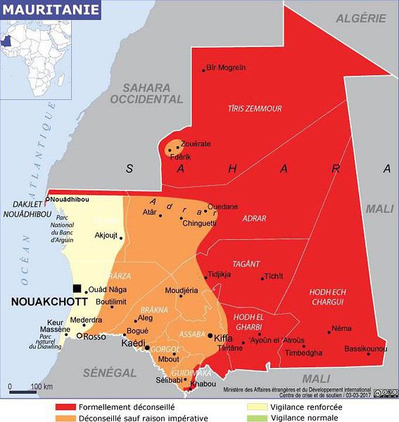
CONSEILS AUX VOYAGEURS CARTE MARS 19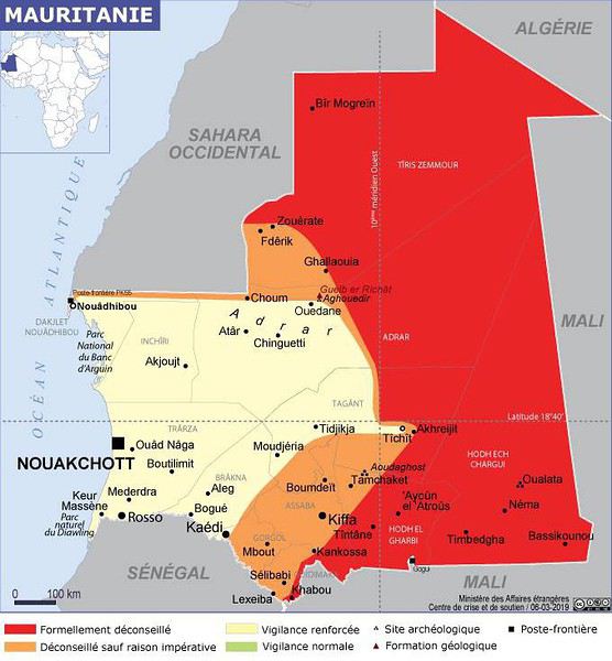
EXEMPLE DE FICHE
PARTIE I
Un mot sur la zone rouge... ou plutôt... bleu blanc sable
Depuis que l'AQMI jusqu'en 2012, puis Boko Haram se sont invités dans la région, et en particulier au Mali, qui partage une très longue frontière avec la Mauritanie sur 2237 km (ah oui quand même!); et y visent des intérêts occidentaux; les conseils aux voyageurs émis par le Quai d'Orsay concernant la Mauritanie sont plutôt alarmistes et décourageants. Mais il faut le dire, les infos fournies ont une facheuse tendance à ne pas être à jour (ce que j'avais déjà eu l'occasion de remarquer pour d'autres destinations comme le Mozambique par exemple). En particulier, les cartes disponibles sur le site France-Diplomatie; qui affichent en rouge les zones formellement déconseillées, en orange les zones déconseillées sauf raison impérative, et en blanc les zones en vigilance renforcée; sont globalement assez dissuasives pour toute visite dans un pays africain et peuvent même faire un peu peur. Je cherche encore un pays avec une zone verte (vigilance normale). Même São-Tomé et Principe; qui est on ne peut plus tranquille, apparaît en zone blanche (vigilance renforcée!)... c'est dire !
Bref, pour mieux cerner la réalité du danger, il n'est pas inopportun de comparer avec les cartes publiées par d'autres chancelleries, et de faire une synthèse des infos.
Ceci étant, même avec un certain retard et un alarmisme toujours excessif, les cartes évoluent... Voir, pour comparaison, les cartes publiées respectivement en décembre 2018 / janvier 2019 puis mars 2019 par le même service (France-Diplomatie via leurs conseils aux voyageurs par pays) Et quand bien même ces quelques critiques sur la tardive mise à jour des informations diffusées, ce site reste bien utile. Une variable à ne pas négliger parmi les multiples paramètres qui définissent "l'évolution de la menace": à l'approche des élections présidentielles dans un pays, une vigilance toute particulière est à considérer.
A savoir...
A l'instar du Mali, la Mauritanie est une ancienne colonie française (de 1902 à 1960) mais elle s'est affranchie du Franc Cfa. Elle possède sa monnaie propre qui est l'ouguiya. (en janvier 2019, 1 euro équivalait plus ou moins à 40 ouguiyas). Il faut retenir que les ouguiyas ont changé de valeur en 2018. Beaucoup de gens -surtout les personnes agées mais pas que- comptent encore en anciens ouguiyas. Il faut s'assurer, quand un prix est annoncé, qu'il l'est bien en nouveaux ouguiyas (qui s'écrivent officiellement num en abrégé, pour les transactions financières mais souvent aussi MRU) et non pas en anciens ouguiyas (qui s'écrivent MRO en abrégé).
Le français est toujours la langue administrative, assez largement utilisée, alors que la langue officielle est l'arabe. Mais la langue courante, populaire, et la plus couramment parlée, est l'hassanya (considéré comme un dialecte arabe, enrichi de diverses influences linguistiques). A noter que la Mauritanie est la seule république islamique d'Afrique. Ce qui implique, pour les femmes, un code de conduite particuler, et le port du voile. Dans les transports en commun, où hommes et femmes non mariés (ou sans lien de parenté) ne sont pas censément autorisés à s'asseoir côte à côte, cela donne lieu à un minutieux casse-tête pour l'attribution des sièges, avec ré-agencement à chaque fois qu'une ou plusieurs femmes supplémentaires montent (ou descendent). Les occidentaux seront autorisés à s'asseoir entre eux comme bon leur semble, étant attendu qu'ils se plient aux usages vis-à vis des locaux. Dans le même ordre d'idée vous remarquerez sans doute que nombre d'hommes ne serrent jamais la main des femmes (en tous cas, pas en public). Pour circuler dans le pays; que ce soit en transports publics ou avec son propre véhicule (pour les voyages organisés; j'ignore quelle est la règle) ; il faut se préparer à fournir une fiche à chaque checkpoint pour ne pas avoir à montrer son passeport à chaque fois. C'est beaucoup plus simple et rapide (et ça soulage tout le monde, le chauffeur comme les autres passagers; qui doivent sinon attendre la fin des formalités). Difficile de prévoir le nombre de fiches necessaires (qui dépend de l'itinéraire de chaque voyageur sur le territoire) mais pour donner une idée, avec une trentaine de photocopies; j'ai été tranquille pour l'intégralité de mon séjour. Pour ce qui est du contenu, voir l'image en fichier attaché qui donne un exemple de fiche. Dans la rubrique "lieux visités en Mauritanie", bien indiquer tous les lieux où vous souhaitez vous rendre. Et laisser un espace en bas pour inscrire le numéro du visa octroyé à l'arrivée. Hors des sentiers battus - si tant est que l'on puisse parler de sentiers battus en Mauritanie- un gendarme zélé peut très bien vous faire remarquer que le village où vous entendez vous arrêter pour la nuit, n'est pas indiqué sur la fiche. Dans ce cas, pas de panique. Qu'à cela ne tienne ! … Avec un bon sourire, rajoutez simplement la destination au stylo dans la rubrique concernée et rendez-lui la fiche ainsi modifiée. Et voilà !... Mais la plupart du temps, l'officier prendra la fiche sans trop s'attarder là dessus; le tout étant que votre identité soit établie et que l'on puisse vous suivre à la trace.
Autre point essentiel : même sans avoir particulièrement besoin ou envie de rester joignable par téléphone pour ses contacts habituels, il est très important, pour se faciliter la vie sur place, d'être joignable par un numéro mauritanien. J'ai rapidement réalisé à quel point c'était utile. Pour cela, il est essentiel de se procurer dès que possible une carte sim mauritanienne, à choisir entre trois opérateurs de téléphonie mobile : Mattel, Mauritel et Chinguitel.
Outre la carte sim, il faut acheter du crédit (appel et/ou internet). Celà se présente sous forme d'un code numérique à entrer dans le téléphone par une petite manip. Pour recharger son crédit de téléphone, aucun problème sur l'ensemble du territoire, dans les petites échoppes qui vendent un peu de tout... et le réseau est globalement bon. Whatsapp fonctienne très bien par sms. En vocal c'est beaucoup plus aléatoire.
CONSEILS AUX VOYAGEURS CARTE JANVIER 19
CONSEILS AUX VOYAGEURS CARTE MARS 19
EXEMPLE DE FICHE
Cycling Through Provence's Big Climbs
Cycling Through Provence's Big Climbs
In the autumn of 2011, Provence was hit by apocalyptic weather—torrential rain and a particularly violent east wind, reaching 130 kilometers per hour, whipping up waves as high as seven meters. It wasn’t the best time to venture outside. Yet, I told myself that after the storm, calm would return. I kept an eye on the weather forecast and noticed that starting November 10th, a favorable window should open for a little 600-kilometer cycling trip across Provence. The weather reports promised a high-pressure system that would keep the bad weather at bay over these highlands. That was all I needed to decide to set off. The planned route would take me through Provence’s biggest climbs: Mont Ventoux, Montagne de Lure, the Verdon Gorge, the Massif des Maures, and Sainte-Baume.
And so, despite my doubts, the call of adventure was stronger. The train pulled away, and once again, a journey began at Part-Dieu station. This time, I headed toward Haute-Provence for a cycling adventure. It would be my first solo bike trip. I was a little nervous—cycling with panniers makes you feel vulnerable to theft. I’d already been robbed while traveling in a group in Peru, and that experience left me deeply shaken. Alone, I hesitated. But no need to panic—I’d read accounts from long-distance cyclists who hadn’t been robbed, even if it does happen sometimes. I was particularly thinking of a young schoolteacher who had taken a sabbatical to cycle around the world. Her students had remarked, "Teacher, you’re not sporty—how will you manage to cycle around the world?" This young woman was full of resourcefulness. In South America, before flying to China, she locked her bike to a post to take care of a natural need. When she returned, the post had been torn out, and her bike—along with all her gear—was gone. It was a shock for many, but not for her. She boarded her flight to the Middle Kingdom, bought the essentials (including a new bike) once there, and continued her journey! Remembering this story, I almost felt ashamed of my cowardice. These were the thoughts running through my mind as the Rhône Valley rolled by toward Orange, the starting point of my Provençal adventure through the big climbs.
Day One: Orange to Sault via Mont Ventoux – 90 km
9:30 AM, I stepped off the train. With all my gear, I had to navigate the underground passage—no easy feat, given that my bike and luggage weighed 35 kilos. At this time of year, I expected some areas to be deserted, so I’d packed enough to bivouac comfortably. Once outside the station, the southern light flooded over me. I understood why people dream of retiring in these sun-drenched regions. As always, after disembarking from public transport, I had to get my bearings and decide which way to go. The sun, still low on the horizon, pointed east. The roar of fighter jet engines helped me locate the Air Base 115. That was all I needed to "reset the gyros."
As soon as I started pedaling, all my apprehensions vanished. The joy of discovery and physical effort took over, and euphoria washed over me. It’s amazing how emotions can shift from one moment to the next based on seemingly minor circumstances.
The weather was splendid—the forecast had predicted continuous showers, but it was completely wrong. I quickly left the city behind. Mont Ventoux loomed mysteriously, its dimensions hard to gauge. It was even more enigmatic with its summit hidden beneath swirling, mottled clouds clinging to the ridges. It reminded me of a great South American volcano. I struggled to imagine that in a few hours, I’d be up there under that blanket of mist.
The countryside was shaking off its autumnal nighttime dampness. The vineyards, interspersed with tall cypress hedges, confirmed I was in the magnificent Côtes du Rhône wine region. The distinctive Dentelles de Montmirail were very much in evidence. The air force base wasn’t far. I passed the runway’s end markers. A Mirage 2000 flew overhead in a tight turn, followed by another roaring into takeoff. It came straight at me before climbing sharply with a thunderous roar. Thirty years spent in that captivating world came rushing back. I recalled countless extraordinary human and technical experiences from my time in the service. But the purpose of this post isn’t to promote the air force—though I might post some articles one day about travels among men at war.
I continued on my way, leaving my past loves behind. As I pedaled, delightful names rolled by: Violès, Vacqueyras, Gigondas, Beaumes-de-Venise—the crème de la crème of the Côtes du Rhône Villages appellation. I let myself be enchanted by the vineyards and the little paths crisscrossing them. I started to doubt my route, though the imposing mass of Mont Ventoux in the distance acted like a giant beacon. At a crossroads, a car appeared. I approached to ask the driver for directions, but she didn’t even look at me and sped off, clearly frightened. I’d almost forgotten what a fearful world we live in, no doubt traumatized by all the horrors we see in the news and on TV.
The kilometers started adding up, but was my day’s goal too ambitious? It had been two months since I’d last ridden my bike. True, my last trip had been good training—the Route des Grandes Alpes—but that was two months ago. I can’t just take my bike out for a day trip; I need that sense of adventure to find the courage to exercise.
Two cyclists overtook me. Intrigued by my load, they struck up a conversation. They were skeptical when I told them I planned to cross Mont Ventoux that day. One of them pointed out a small chapel near the summit where I could bivouac sheltered. That motivated me even more to reach the top on this first stage. The chapel also had a mythical name for me—Sainte-Anne, the name of my parents’ villa. It was already noon, and I’d covered 50 kilometers. Malaucène appeared—the sacred village of Ventoux’s mad cyclists. Surprisingly, I didn’t see any other cyclists today. I remembered this place in June, teeming with aspirants for the king of summits. Before tackling the climb ahead, I needed to refuel. I enjoyed a pleasant gastronomic break at Max’s. At 1 PM, I started the most famous climb in cycling—21 kilometers, which would actually be 23. I knew it would be tough, especially with two handicaps: 50 kilometers already in my legs and 20 kilos of luggage. But I was counting on my tiny chainring, which let me climb trees to tackle the steep ramps.
I set off at a brisk pace along a deserted road. My speed held up for the first few kilometers. I quickly rose above the valley, the horizon widening. I was surprised to see no one on this world-renowned route among cycling enthusiasts. During the climb and descent, I’d only see five cyclists—but I’ll come back to that. I passed a sign explaining that the effort would be roughly equivalent to climbing the Col de la Bonnette. Having done the latter in September, I figured I’d be fine. I crossed paths with my first cyclist—a woman speeding downhill. After 12 kilometers, I hit slopes averaging 12%. I don’t know if the number 12 is cursed, but I got such a "bamboo" hit that I’d never experienced before. I thought I wouldn’t make it to the summit today. I stopped. My thighs burned so much I could barely walk—lactic acid overload. I looked for a relatively flat spot to pitch my tent. It was 3:30 PM, with two hours of daylight left. But I found nothing.
I got back on my bike, intending to stop as soon as I found a good bivouac spot. But nothing came up. However, my strength slowly returned, perhaps because the slope eased, though it remained around 10%. I entered the summit mists. A cyclist overtook me. I was in the zone where I had to pass the summit. Dusk caught me in the final difficulties. The atmosphere was downright austere. In the twilight, a kilometer from the summit, a cyclist was fixing his bike. I asked if he needed help. He made it clear he didn’t understand. So I asked, "Do you need some help?" His answer was clear: "No, thank you." He showed me his new inner tube. Inside, I thought, "Phew!" If I’d had to stop, sweating in the falling night with the cold intensifying, I’d have struggled to get going again. But he managed, and I continued into the twilight fog. I could barely make out the summit’s large antennas in the clouds, like immense ghosts trying to evade sight. The bike delivered sensations worthy of mountain racing. My goal was to quickly find the famous chapel in the descent to take shelter. As I glided down the southern slope, two cyclists without lights crossed my path in the night—probably heading to the station above, its lights visible in the fog.
I scanned the roadside in the dark for the chapel but saw nothing. After a kilometer or two, I lost all hope. I stopped to put on more clothes as the cold became intense. I had no idea where I could stop on these steep slopes to set up camp. Between the swirls of mist, I could intermittently see the Rhône Valley below, dotted with illuminated towns and villages. The sight was striking. What was I doing on this mountain at night? Then the miracle happened—the clouds parted, and from the ridge above me to the east, a beautiful full moon emerged, casting enough light to consider a nighttime descent to Sault, 26 kilometers away.
In this eerie atmosphere between the moon’s pale rays and patches of fog, I began my descent through a hazy, almost unreal world. The Ventoux’s characteristic white scree reflected the moonlight faintly, dimmed by the mist. In places, entire mountainsides were plunged into complete darkness, and I lost all sense of the road’s path. Then, around a tight bend caused by a land shift, the light returned. It seemed extreme compared to the darkness I’d left behind. I could once again clearly see the road’s contours, though not its potholes or gravel patches. Still, I let the slope carry me, and the speed felt significant, though the low light prevented me from reading my speedometer. In these moments, concentration was at its peak—all senses alert, reflexes ready to react to the slightest incident that could lead to a fall.
I was relieved to see Sault’s lights growing closer. In less than an hour, I reached it, considering the final little climb that required one last push. This village, bustling in summer, was deserted at this time of year—almost dead. The first hotel I came across was closed. A quick shadow passed in a small sloping street. Before it disappeared into the darkness at a house corner, I chased after it and asked about accommodation options. Very kindly, I was directed to what was probably the only hotel open in November. I quickly found it, and the reception was open. I entered wearing my black balaclava, bought in the Ayacucho region—the birthplace of Peru’s Shining Path. At this late hour, I saw questioning glances directed at me. I prefaced, "This isn’t a hold-up." Clearly, the owners had a sense of humor—they started smiling. I took off my balaclava and asked for a room. No problem, and from that moment, the pressure eased. I really didn’t feel like going back out to find a spot to pitch my tent in the biting cold.
The stage had been nearly 100 kilometers, and it was the first. It had been two months since I’d touched my bike, and I probably lacked even minimal training, even though my last bike trip had been crossing the French Alps. I really had to dig deep to overcome my weakness on Ventoux’s steep section. I don’t remember ever having to search so deeply for the energy to keep going. I knew the stage I’d set for tomorrow was significant, with the climb up Montagne de Lure’s northern slope—Ventoux’s little sister, whose ascent is reputed to be endless, over 25 kilometers. I hoped this first day wouldn’t leave me too sore to avoid suffering excessively tomorrow.
For now, relaxation—a hot shower did me a world of good, followed by a good meal. I ate a delicious andouillette from Troyes, very fine, with a particularly successful herb seasoning. I loved it, and yet I’m from Lyon and pride myself on knowing a thing or two about andouillette—not just a sausage but a whole category! A bit chauvinistic, I had to admit, though reluctantly, that I found it better than the ones I usually eat in the Lyon region!
Day Two: Sault to Forcalquier via Montagne de Lure – 116 km
This morning, the weather was magnificent—the air clear, still, very fresh, and invigorating, as only the late season can offer on these Provençal highlands. In summer, they’re known for their scorching heat and drought, but often overlooked is how harsh they can be with cold and storms. Authors like Giono or Bosco described them and their inhabitants wonderfully in books like "Les Âmes Fortes."
The miracle of the night had worked. I wasn’t sore anywhere and felt in great shape. I set off well-equipped, but the effort and sun soon made me sweat. It was time to shed some layers—hat and gloves. A gentle warmth replaced the cold, making for excellent cycling conditions. On the road to Trinit, there was no traffic—only the occasional hunters’ cars parked in the distance. These vehicles were recognizable by their large cages, used to transport hunting dogs. Sometimes, the silence was broken by a distant gunshot. The deciduous forests were losing their foliage, taking on that dull brown hue of late autumn, though here and there, a tree or shrub still resisted, displaying vivid yellow or red. The meadows, their grass already scorched by the cold, were damp from the night’s heavy humidity. The low sun highlighted thousands of spider webs that had trapped insects during the warm season.
Behind me, Mont Ventoux dominated these vast spaces. As often, its imposing, stony summit was crowned with a blanket of clouds. What an impressive mountain—it’s always so hard to gauge its dimensions. I struggled to realize that last night I’d been at the summit and descended its immense southern ridge in the dark. I hoped to return one day in favorable conditions—daylight and no clouds—to enjoy the vast panorama from this unique summit.
Leaving the very Provençal village of Trinit, I tackled my first climb of the day—the Col de l’Homme Mort. The road rose moderately for five kilometers in gentle warmth. The view over the region widened, and I felt the sheer joy of pedaling. At a good pace, I overcame this first little challenge. Once at the pass, I couldn’t resist the ritual of photographing my bike in front of the sign, giving the name and altitude—1,213 meters.
The northern slope was austere and still in shadow. The cold bit again. The road was wet and covered with leaves in places. It wasn’t impossible that some treacherous patches of black ice lurked around a bend. I descended toward the Jabron Valley with caution. Suddenly, around a bend in a forest clearing, the freshly snow-covered Alps, gleaming in the sun, leapt into view, blocking the horizon. I thought I recognized the distinctive silhouette of the Écrins’ south face above a multitude of jagged peaks.
This snow and these mountains awakened a flood of memories of great joys, but I also thought of the guide and his client who had just lost their lives on the Grandes Jorasses’ north face, at the top of a route called the Linceul. The name comes from the face’s appearance—a great ice slope bordering the Grandes Jorasses’ north wall. It was first climbed by René Desmaison in 1968. He passed away a few years ago and, in his final wishes, asked that his ashes be scattered in the Dévoluy Massif at the foot of Pic de Bure, not far from here in these immense pre-Alpine folds.
At my feet, the Jabron Valley stretched almost endlessly east toward Sisteron. In the distance, the dark mass of Montagne de Lure’s north face loomed. This mountain shares similarities with Mont Ventoux. It has the same summit scree of bright limestone, the same forests climbing up to the final rocky stretch, and that blanket of clouds adding a secretive, austere touch to the scene.
I turned left past the town of Séderon and headed toward the little Col de la Pigière, which in a few kilometers allowed me to truly plunge into the beautiful Jabron Valley. I passed through several villages with charming local names—Saint-Vincent, Noyer-sur-Jabron. The river offered lovely views of its narrow gorges with clear, cold water. Autumn seemed less advanced here than on the plateau I’d just left. Many trees still wore brilliant colors, some revealing extraordinary hues—mixes of crimson, pink, and bright red.
Arriving in Noyer-sur-Jabron, I took a tiny road on the river’s right bank, leading in a few kilometers to the foot of Montagne de Lure. In the village of Valbelle, I picnicked on leftovers I’d brought from home—an old cheese and a somewhat stale loaf of bread. It was 1:30 PM. I began the long climb of about 25 kilometers. According to a friend who’s a cycling expert in the region, this section is tough. No wonder it’s called Ventoux’s little sister—the Mont Blanc of cyclists. The elevation gain on this side is still 1,200 meters, while Ventoux via Malaucène is nearly 1,600 meters.
I hoped to reach the summit before nightfall and avoid reliving a nighttime descent. The route wound through a vast forest, following the terrain’s folds. There was activity—mushroom hunters were busy searching for the coveted chanterelle. The climb, though never very steep (only one kilometer at 9%), was interminable. Though traffic was practically nonexistent, I was overtaken by a group of Harley bikers—I counted about forty. Perched high on their machines, hands in the air on wildly shaped handlebars, some with their feet nearly in the sky due to the high footpegs, they didn’t even glance my way. What’s this idiot doing, unable to ride a motorcycle and forced to climb these mountains on a bike with big bags! I wasn’t offended—real Harley purists often see other motorcyclists as renegades, so bikes are even lower on the totem pole! But I didn’t want to start a debate about motorcycles. In my youth, when I was a wild motorcyclist (22 accidents on two wheels), clans were divided into Japanese, German, Italian, and British bike owners. The latter, on their vibrating, oil-leaking machines, considered themselves the purest. But let’s not fight—there’s a statute of limitations, and it’s been nearly forty years.
As yesterday, a few kilometers below the summit, I entered the fog, and the light dropped suddenly. What a hostile mountain in these conditions! It heightened the sense of living an incredible experience. The conditions we encounter play a major role in how the adventure imprints on our memory. I realized once again that in France, you can feel like you’re very far away. Finally, after this very long climb, the Pas de Graille sign suddenly appeared out of the grayness. Strange! Below the sign, a kilometer marker indicated this same pass was over three kilometers away. Clearly, the climb continued. In these final kilometers through the scree, I gained another 130 meters of elevation. Finally, the road’s high point was reached—1,720 meters. It was cold and damp. I quickly covered up, added my balaclava under my helmet, and put on warm gloves. As I was about to start the descent, a car stopped at the summit, and one of the passengers was surprised to find a bike there in these chilly, twilight conditions.
A 20-kilometer descent led me to the village of Saint-Étienne-les-Orgues. I hoped to find a place to stay for the night. No such luck! Everything was clearly closed—no chance of finding shelter. Tonight was getting complicated. I already had exactly 100 kilometers in my legs and didn’t feel like pedaling anymore, especially at night. But I had even less desire to sleep outside. What to do to avoid it? The town of Forcalquier was 16 kilometers away—I hoped the road would descend. I set off in that direction. The first third was along a beautiful, lightly trafficked departmental road with a slight downhill—I pedaled hard. But it got tougher. I joined a busier road, and night had fallen. A several-kilometer climb finished the journey. I knew my magnetic lights weren’t very powerful—hence the danger. They were even less so on the climb because the slower I went, the less they illuminated. Cars coming the opposite way often saw me late and blinded me with their high beams. After passing, I was plunged into total darkness for a few seconds while my pupils readjusted to the night. I imagined those coming up behind me saw me with little warning, despite my slightly fluorescent jacket. When the roadside was clear, I always positioned myself to quickly jump off the road. But unfortunately, in this long final climb, a guardrail prevented any escape to the right in case of sudden braking behind me. That was even more anxiety-inducing since I was stuck at a snail’s pace. Time seemed long. I pedaled as hard as I could, on the verge of asphyxiation, trying to escape this dangerous situation as quickly as possible. My only reference point was the vehicles in front of me, letting me know the climb wasn’t over. Then suddenly, the ordeal ended—the road’s high point was reached. The town and its lights emerged from the void, and clarity returned. Phew! I glided down toward this little town bathed in light. On November 11th, I hoped to find an open hotel since I’d clearly exceeded 100 kilometers, and the idea of having to leave town to find a bivouac spot somewhat frightened me.
I arrived in the town center. Activity was low. The first hotel was closed, but I spotted a lit sign for another establishment further on. I headed there, got off my bike, and entered. The welcome was immediately friendly—a big cat came to rub against me. For me, that was a very good sign, and the first impression was confirmed. I still had to go out to eat. I covered the minimum distance. A restaurant advertised "Mom’s Cooking." I expected Provençal specialties, but they were Moroccan. I chose a delicious tagine with lime and olives, followed by almond and honey ice cream. Exhausted after this 116-kilometer stage, I returned to my room. As often after intense efforts, it was hard to fall asleep.
Day Three: Forcalquier to Moustiers-Sainte-Marie – 58 km
On this third day, due to the progress made yesterday, the stage would be short. I’d call it a transition between two mountain ranges. Indeed, the next big climb is the Verdon Gorge. I planned to position myself at its foot this evening in preparation for a tough stage tomorrow. I made a few purchases—bread, bananas, and medicine for stomach burns (the midday sausage wasn’t always kind to me). The weather was still perfect. The route began with a long descent toward the Durance. It’s always nice to start a cycling day with a downhill—it boosts morale and allows for a gentle warm-up.
I quickly reached the town of Oraison. Just at its entrance, I crossed the Durance, which still bore traces of last week’s heavy rains along its sandbanks. Indeed, numerous stumps and trunks were scattered along its vast gravel bed, along with less ecological debris like old tires.
A little south of Oraison, I took the D907, a small road heading due east between scrubland and meadows. There it was—the Provence we imagine. This stable autumn weather, with still air, neither hot nor cold, just a fresh feeling when emerging from a shaded valley or a slight warmth under the sun, was ideal for a cyclist. After about ten kilometers at the bottom of a small valley I quickly passed through, the village of Le Brunet appeared on the right. It clung to the slopes leading to the Valensole Plateau. A few steep kilometers along a tiny winding road, and suddenly a vast panorama unfolded as the climb ended.
What a magnificent plateau! Though known for its wind, luckily today was completely calm. Far to the east, the Verdon’s great cliffs blocked the horizon. This allowed me to contemplate part of tomorrow’s stage. This place is full of mysteries—many UFO and extraterrestrial encounter stories are associated with it. Moreover, for about thirty years, France hid its ground-to-ground nuclear ballistic missiles here, grouped in the 1st GMS (Ballistic Missile Group), under the air force. Naturally, these rockets fueled fantasies, and pacifist groups settled in the region to protest this type of armament. This gives many reasons to shroud this austere, deserted land in mystery.
I took a dirt path leading to the heart of this zone and stopped at the forest’s edge for lunch. The silence was total, the view stretched very far. But nothing strange or bizarre manifested. No Martian came to share my frankly moldy cheese, very peppery sausage, or bruised banana—sniff! I resumed my route, and as often when crossing places with strong character, I tended to slow down to enjoy them longer. The immense lavender fields stretched endlessly, not very fragrant at this season. I arrived at a group of truffle oaks protected by a fence, with large red signs warning "Firearm." Clearly, the war for the black diamond was raging in this region. I remembered a novel where an old farmer made buyers believe nothing grew on his land. Every year, he secretly stole the mushrooms from the unsuspecting owners. Then one day, they discovered the truth, catching this "polite" neighbor trying to hide a basket full of beautiful, large truffles!
In these vast spaces, I felt good—a sense of plenitude. It’s strange that I only conceive of cycling through wandering. I struggle to plan a day trip. And if I do, it’s highly likely I won’t get up. I need that sense of adventure to fully appreciate my physical effort. Maybe one day I should get psychoanalyzed, but at my age, it’s probably too late! Today, I had all the time in the world—the stage was half as long as yesterday’s, with very little elevation gain. Not a sound, an impressive calm, a beautiful landscape—I pedaled in a wonderful place. That’s probably happiness!
I reached the village of Puimoisson on the plateau’s eastern edge—only 12 kilometers left to Moustiers. I took my time, sat at a café terrace in the sun, and leisurely enjoyed a coffee while listening to the village come to life. I was delighted by these melodious southern voices, bursting into great laughter. There are places where, despite the anxieties caused by our debt-ridden, dysfunctional societies, some have decided to take life on the bright side and show a saving insouciance.
The rest of the journey was a simple formality—I let the slope carry me toward the pretty little town of Moustiers-Sainte-Marie, clinging to the cliff and famous for its faïence. Arriving early for once, I went to the tourist office to choose a comfortable hotel. Indeed, the Hôtel des Restanques was very comfortable and admirably well-located. But at this time of year, I’d have to return to the village center for dinner. The very kind receptionist reserved a table for me at La Treille Muscate, a restaurant with a magnificently arranged room on the church square. It was only 3:30 PM—I continued to take my time, showering and relaxing in front of the TV. Then I set off to explore—or rather, re-explore—this village I’d visited several times before. But I’d never climbed to its chapel perched in the middle of the great cliff towering over the houses. A stony, aerial path led there. The first mentions of the Notre-Dame de Beauvoir chapel, known in ancient times as Notre-Dame d’Entre-Roches, date back to the 9th century. It’s one of the rare "respite" chapels found in Provence. These are chapels where stillborn children were brought to be revived for a few moments, just long enough to baptize them. They could then be buried religiously, ensuring the salvation of their souls. I was also very moved by reading some ex-votos, like the one from "A mother for her three children returned from the war."
The place was impressive, especially as night fell. I was alone and watched the shadows fill the great cliffs above me. With an old climber’s reflex, I looked for possible climbing routes among these slabs and cracks. But climbing is probably forbidden here, too close to the houses. Then I descended to stroll through the village, admiring the magnificent, finely crafted faïence patterns found in many shops. Finally, dinnertime arrived, and I joined my restaurant, which had been highly recommended. I was delighted by the foie gras ravioli and the pieds et paquets—the chef’s specialty. I’ll come back with family.
Day Four: Moustiers to Fréjus via the Verdon – 122 km
A hearty breakfast prepared me for the day’s tough efforts. Next to me, four Chinese people chatted animatedly. Of course, I didn’t understand a word—it was a language with strange intonations and sounds. I left the dining room and prepared my bike on the terrace. Seeing the volume of my luggage, my Chinese friends rushed over and asked to take turns having their photo taken in front of this funny setup. All laughing, they took photos in front of what they probably considered a French coolie off on some trading business! When they show these photos to their relatives, they’ll likely be perplexed about what motivates some to travel by bike rather than car. For them, the car is a symbol of success—according to an article I read last year, 14,000 cars are registered in China every day!
This morning, the air was fresh. As yesterday, I started with a long descent, this time leading to the edge of Lac de Sainte-Croix. A strong, biting headwind slowed me down. It wouldn’t last, as it was generated by the gorge’s outlet, which I’d reach in a few kilometers. On this cold morning, the lake’s shores exuded great tranquility. The sun was still hidden behind the Verdon’s mountainous mass. Trees with yellow leaves stood out against the water’s pale blue. The bridge marking the gorge’s beginning at the lake’s edge was an ideal spot to admire this natural splendor. At this early hour, the play of light and shadow on the water and the immense cliffs delivered a grandiose spectacle in beautiful harmony. This first contact with the gorges, which I knew well, amazed me.
Once past the bridge, the wind calmed. A little further on, I began the long climb that would take me to the top of this immense natural gash, which water had taken millions of years to carve. I was in good shape and highly motivated by the splendors to come. First, I reached the village of Aiguines, which offered a magnificent viewpoint over the lake. Then I continued toward the Corniche Sublime, where countless breathtaking panoramas unfolded as I progressed. But the climb was sustained and long, requiring effort—though my small chainring worked miracles. I first passed the Col d’Illoire, already 500 meters above the lake. Seeing all these great cliffs, countless climbing memories came flooding back. The classic routes of the Escalès cliff, over 300 meters high, flashed by. Routes with legendary names—La Demande, Les Écureuils, Luna-Bong, and many others. The one that left me with the best memory was ULA—a crack, vertical or even overhanging, of sheer beauty rising above a 40-meter slab in one go for 280 meters of sustained, beautiful climbing on extraordinary rock. It made me want to return to climb there, to immerse myself in the atmosphere of those past times. But climbing habits have changed—now routes are accessed from above by rappel, and people don’t always bother to do these great climbs in their entirety, focusing instead on shorter but technically much more difficult enterprises.
At almost every bend, I stopped and scanned these great cliffs, searching for memories of past experiences and emotions in these secret rock folds. The road climbed well above the pass, exceeding 1,200 meters. It was cool, especially since I was sweating. Finally reaching the high point of the Corniche Sublime, I couldn’t gain speed on the descent—my gaze was always drawn to this astonishing canyon. Around a bend, two cyclists with funny small-wheeled bikes. Wow! It was a couple of Australians doing a year-long tour of France. We chatted passionately about our two-wheeled experiences for a moment. But time was passing, and if I wanted to reach Fréjus before nightfall, I’d have to pedal seriously.
I stopped at the Pont de l’Artuby, where bungee jumping was in full swing. But I quickly set off again toward Comps. The wind was against me, and it was climbing. I started to doubt whether I’d make it to the coast that evening. At 2 PM, I was in Comps-sur-Artuby. I didn’t stop, knowing that before reaching the coast, I’d have no alternative to bivouacking, and I had 70 kilometers left to cover. Sure, it should be downhill, but a few climbs were on the program. After a descent out of the village, I crossed the Artuby River again on the Canjuers military camp. A several-kilometer climb followed, fortunately not too steep. I took the D19 toward Barjols. From there, despite the late hour, I opted for a tiny road passing through Claviers, a small perched village. Time passed quickly, but the kilometers added up. I regained hope. Fifteen kilometers after this last village, I reached Saint-Paul-en-Forêt via a magnificent forested route. I had plenty of time to observe mushroom hunters. I asked one who clearly had some in a plastic bag. He gave me this hilarious answer with a magnificent southern accent: "I only picked the bad ones." No reply was possible. I moved on with a smile. A little further on, another hunter carried a basket. As soon as he saw me, he quickly hid it—just in case I saw what it contained. Arriving at the village involved a steep climb, and I was close to 100 kilometers. I still had a little over 20 kilometers to go before reaching Fréjus. The race against nightfall had begun. Over there to my right, I saw the sun setting behind Roquebrune-sur-Argens’ distinctive rock. The sea appeared. There it was—I was in Fréjus’ industrial zone. On this Sunday evening, traffic was heavy. Indeed, many had taken advantage of the return of good weather after very heavy storms to go for a walk. After quite a few detours, I arrived at the seaside just as night fell. My odometer showed 122 km for the day. I quickly found a simple hotel, ate just as quickly, and went to bed.
Day Five: Fréjus to Solliès-Pont – 92 km
Once again, the night had done its restorative work, and I prepared to cross the Massif des Maures feeling quite fresh. The weather forecast was still favorable for today, but a deterioration was expected tomorrow. I tended to trust it because the east wind was blowing, and in the region, that’s a sign of rain. For now, in the short term, this wind would be very useful—it would push me generously throughout the day.
I started calmly along the harbor quays, looking at the boats. Then I joined the road to Saint-Aygulf and followed the coast for forty kilometers to Port-Grimaud. All these seaside resorts—Saint-Aygulf, Les Issambres, Sainte-Maxime—reminded me of my youth when we spent all our vacations fishing, whether from shore, underwater, or by boat. Looking at the sea roll by, I knew what the seabeds looked like under that surface hiding them. The marine areas we knew best were now under the parking lots and commercial zones of Saint-Raphaël’s new port. In our youth, these infrastructures didn’t exist, and their construction came at the expense of coastal marine areas. Our wonderful fishing spots were permanently buried. I remember seeing the first big trucks that came to dump their loads of earth and rubble, destroying all those wonderful places—sandbanks, seaweed beds, groups of rocky holes teeming with fish that enchanted our youth. Over forty years later, I can still visualize them in my imagination under those parking lots and stores, with the names we gave them—my brothers and I: le casse-croûte, le casse-pipe, les montagnes, la digue, la grille, la mare à mulets, la petite-plage, le trou, etc.
Let’s not be overwhelmed by nostalgia. I left the coast and took the little road through the Maures to Collobrières. The route led from ridge to ridge following the terrain’s movements. At this time of year, the region was admirable. Due to the heavy storms of recent weeks, water was streaming everywhere. Waterfalls and streams murmured all along the way. I didn’t recognize the Maures, which I knew for their dryness causing apocalyptic fires. Indeed, around a bend, I came across a small rest area where a memorial had been erected for three firefighters who lost their lives here while fighting one of those gigantic fires fanned by the mistral.
This forest holds treasures—first, the cork oak, then the arbutus, chestnut trees, and of course, mushrooms that love this granitic soil:
The cork oak can be found all along the road. It’s the forest’s essential element. You can recognize it by its light bark (before exploitation), which forms large bulges along the trunk. But after exploitation, the trunks are much smoother, less voluminous, and dark in color. The arbutus is a large berry with red skin covered in small protuberances, growing on the arbutus tree. This fruit, common in Mediterranean areas, ripens in November. That means today, there were plenty around me. Its flesh is orange, with the consistency of firm purée, and it crushes softly in the mouth. The taste of this berry is sweet and excellent. I didn’t hold back—I gorged myself on them, which served as my midday meal. Sometimes I had to climb embankments to get them.
The chestnut tree, a true industry of the region, brings wealth to the surrounding villages. They make candied chestnuts, ice cream, and other products derived from chestnut flour. Be careful not to stop just anywhere to pick this fruit, as the tree owners might not agree. They even make this clear with signs and surround their chestnut trees with fences. Mushrooms—saffron milk caps and porcini—are highly prized in the area. I saw a few hunters, but it clearly wasn’t miraculous. Supposedly, there had been too much rain?
There’s no time to get bored along this little road, from which you can sometimes see the sea. I passed the Col de Taillude at over 400 meters. I began the descent to Collobrières, the chestnut capital, whose festival attracts many people. Before entering, about a hundred meters from the first houses, a cyclist—probably an agricultural worker—came toward me. As he passed, he cheerfully called out, "Go on, little guy! It’s almost there!" We both smiled. At the end of November, the village was cold and almost deserted. Dead leaves swept the wet streets of the town. You could feel winter on the way. I continued my route to Pierrefeu-du-Var, on the western edge of the Massif des Maures. So I gave my last pedal strokes in this pretty little massif so characteristic of Provence.
I looked for a hotel in Cuers but without success. I descended toward Toulon and finally found one on the outskirts of Solliès-Pont. It catered to people coming to work in the region, so nothing very bucolic. But if the weather were to deteriorate tomorrow and turn to rain, I could quickly reach Hyères or Toulon station, which was a significant advantage. Indeed, November rains aren’t usually very pleasant on a bike.
Day Six: Solliès-Pont to Cassis via Sainte-Baume – 85 km
This morning, contrary to the weather forecast, the weather was beautiful, and the latest bulletin seemed to contradict yesterday’s. So no escape to Toulon—I resumed my route toward Sainte-Baume. I left the hotel via a tiny road that, through ups and downs, led me via shortcuts to the road to Belgentier. My body had gotten used to intense daily efforts, and I felt in Olympic form. At a good pace, I launched into a long climb with a moderate slope. The road was busy, but fortunately, the side lane for cyclists often made the exercise more pleasant. The villages rolled by—Méounes, La Roquebrussanne. Near the latter, I observed a Tiger combat helicopter in training. It hovered motionless for long periods—perhaps the pilots were training to master their increasingly sophisticated weapon systems, requiring even more learning?
I left the busy road and headed via an almost deserted route toward the village of Mazaugues. The climbs became steeper. A long descent, and there I was in this pretty village. A grocery store, which besides selling a few ingredients also served as a café. I sat near the electric heater—it was cold, and I was sweaty. I watched customers come and go and listened to the shopkeeper tell me about village life. The name Mazaugues comes from "water mass," which is why drought doesn’t usually affect this area. Apparently, you can even find mushrooms here in summer! I had a good time, and as I was leaving, a local cyclist started a conversation and told me about her dreams of long bike trips, currently limited by her situation as a mother of terrible children. She settled for day trips with her club, which was already good in this very hilly region. I told her the story of a man who, at 73, cycled solo around Morocco. So no panic—she still had thirty or forty years to realize her wildest dreams!
I was warned that it would be a tough climb to reach Sainte-Baume’s northern slope. Indeed, over eight kilometers, the average slope was sustained, but the landscape was wonderful. Here too, water was streaming everywhere. I passed one of those famous icehouses that used to supply Marseille with ice throughout the year. This northern slope of Sainte-Baume is very cold, and this characteristic was exploited in previous centuries to produce ice. Large cylindrical structures, well-protected to the north and semi-buried, received large quantities of water in late autumn, which froze during winter and was kept cool for months until the following winter. Ice blocks were cut and delivered by cart to the city. That’s how, in ancient times, ice was available in summer to keep fish fresh in Marseille. Did pastis exist at that time? If not, the ice cubes must have been bored!
Once the climb was over, the long ridge of Sainte-Baume appeared, and I could see its characteristic antennas. Nestled at the foot of the cliffs, the magnificent millennial forest revealed itself with its autumn colors. I stopped at the monastery. I’d been there several times before and had even slept there during a long walking trip. The welcome had been first-rate by the Dominicans, especially the sisters in their long immaculate robes. They radiated a serenity that was very contagious. Don’t hesitate to stop there for the night. I struggled to get back on my way—some places have a special spirit.
I was soon at the end of my journey. I continued along this magnificent mountain to the Col de l’Espigoulier. To the north, another immense wave of white limestone rose—Montagne Sainte-Victoire, a high place in Provence that painter Cézanne made world-famous. Once at the pass, the entire city of Marseille spread out at my feet, the Mediterranean coast revealed itself from the Calanques to La Ciotat, passing by the famous Cap Canaille, Europe’s highest sea cliff. Above me, bathed in sunlight, Bartagne’s northwest face, very popular among climbers, showed all its reliefs. With an old climber’s reflex, I spotted the many climbs I’d done there. I let myself be carried into a steep, winding descent toward the village of Gémenos in a beautiful setting full of cliffs.
A few more kilometers of climbing toward the Col de l’Ange, then toward Roquefort-la-Bédoule. In this last climb, I raced with two cyclists, admittedly not very young. Then, in a six-kilometer descent, I reached Cassis station, the endpoint of my six-day journey through this wild Provençal land between sea and mountain. I experienced great pleasure during these 570 kilometers through these renowned yet wild French massifs. As always, when a beautiful project comes to an end, you feel a bit orphaned by a beautiful dream come true. You have to quickly envision the next one to avoid a vague sense of emptiness taking over. My next adventure is already taking shape in my mind, but that’s another story.
In the autumn of 2011, Provence was hit by apocalyptic weather—torrential rain and a particularly violent east wind, reaching 130 kilometers per hour, whipping up waves as high as seven meters. It wasn’t the best time to venture outside. Yet, I told myself that after the storm, calm would return. I kept an eye on the weather forecast and noticed that starting November 10th, a favorable window should open for a little 600-kilometer cycling trip across Provence. The weather reports promised a high-pressure system that would keep the bad weather at bay over these highlands. That was all I needed to decide to set off. The planned route would take me through Provence’s biggest climbs: Mont Ventoux, Montagne de Lure, the Verdon Gorge, the Massif des Maures, and Sainte-Baume.
And so, despite my doubts, the call of adventure was stronger. The train pulled away, and once again, a journey began at Part-Dieu station. This time, I headed toward Haute-Provence for a cycling adventure. It would be my first solo bike trip. I was a little nervous—cycling with panniers makes you feel vulnerable to theft. I’d already been robbed while traveling in a group in Peru, and that experience left me deeply shaken. Alone, I hesitated. But no need to panic—I’d read accounts from long-distance cyclists who hadn’t been robbed, even if it does happen sometimes. I was particularly thinking of a young schoolteacher who had taken a sabbatical to cycle around the world. Her students had remarked, "Teacher, you’re not sporty—how will you manage to cycle around the world?" This young woman was full of resourcefulness. In South America, before flying to China, she locked her bike to a post to take care of a natural need. When she returned, the post had been torn out, and her bike—along with all her gear—was gone. It was a shock for many, but not for her. She boarded her flight to the Middle Kingdom, bought the essentials (including a new bike) once there, and continued her journey! Remembering this story, I almost felt ashamed of my cowardice. These were the thoughts running through my mind as the Rhône Valley rolled by toward Orange, the starting point of my Provençal adventure through the big climbs.
Day One: Orange to Sault via Mont Ventoux – 90 km
9:30 AM, I stepped off the train. With all my gear, I had to navigate the underground passage—no easy feat, given that my bike and luggage weighed 35 kilos. At this time of year, I expected some areas to be deserted, so I’d packed enough to bivouac comfortably. Once outside the station, the southern light flooded over me. I understood why people dream of retiring in these sun-drenched regions. As always, after disembarking from public transport, I had to get my bearings and decide which way to go. The sun, still low on the horizon, pointed east. The roar of fighter jet engines helped me locate the Air Base 115. That was all I needed to "reset the gyros."
As soon as I started pedaling, all my apprehensions vanished. The joy of discovery and physical effort took over, and euphoria washed over me. It’s amazing how emotions can shift from one moment to the next based on seemingly minor circumstances.
The weather was splendid—the forecast had predicted continuous showers, but it was completely wrong. I quickly left the city behind. Mont Ventoux loomed mysteriously, its dimensions hard to gauge. It was even more enigmatic with its summit hidden beneath swirling, mottled clouds clinging to the ridges. It reminded me of a great South American volcano. I struggled to imagine that in a few hours, I’d be up there under that blanket of mist.
The countryside was shaking off its autumnal nighttime dampness. The vineyards, interspersed with tall cypress hedges, confirmed I was in the magnificent Côtes du Rhône wine region. The distinctive Dentelles de Montmirail were very much in evidence. The air force base wasn’t far. I passed the runway’s end markers. A Mirage 2000 flew overhead in a tight turn, followed by another roaring into takeoff. It came straight at me before climbing sharply with a thunderous roar. Thirty years spent in that captivating world came rushing back. I recalled countless extraordinary human and technical experiences from my time in the service. But the purpose of this post isn’t to promote the air force—though I might post some articles one day about travels among men at war.
I continued on my way, leaving my past loves behind. As I pedaled, delightful names rolled by: Violès, Vacqueyras, Gigondas, Beaumes-de-Venise—the crème de la crème of the Côtes du Rhône Villages appellation. I let myself be enchanted by the vineyards and the little paths crisscrossing them. I started to doubt my route, though the imposing mass of Mont Ventoux in the distance acted like a giant beacon. At a crossroads, a car appeared. I approached to ask the driver for directions, but she didn’t even look at me and sped off, clearly frightened. I’d almost forgotten what a fearful world we live in, no doubt traumatized by all the horrors we see in the news and on TV.
The kilometers started adding up, but was my day’s goal too ambitious? It had been two months since I’d last ridden my bike. True, my last trip had been good training—the Route des Grandes Alpes—but that was two months ago. I can’t just take my bike out for a day trip; I need that sense of adventure to find the courage to exercise.
Two cyclists overtook me. Intrigued by my load, they struck up a conversation. They were skeptical when I told them I planned to cross Mont Ventoux that day. One of them pointed out a small chapel near the summit where I could bivouac sheltered. That motivated me even more to reach the top on this first stage. The chapel also had a mythical name for me—Sainte-Anne, the name of my parents’ villa. It was already noon, and I’d covered 50 kilometers. Malaucène appeared—the sacred village of Ventoux’s mad cyclists. Surprisingly, I didn’t see any other cyclists today. I remembered this place in June, teeming with aspirants for the king of summits. Before tackling the climb ahead, I needed to refuel. I enjoyed a pleasant gastronomic break at Max’s. At 1 PM, I started the most famous climb in cycling—21 kilometers, which would actually be 23. I knew it would be tough, especially with two handicaps: 50 kilometers already in my legs and 20 kilos of luggage. But I was counting on my tiny chainring, which let me climb trees to tackle the steep ramps.
I set off at a brisk pace along a deserted road. My speed held up for the first few kilometers. I quickly rose above the valley, the horizon widening. I was surprised to see no one on this world-renowned route among cycling enthusiasts. During the climb and descent, I’d only see five cyclists—but I’ll come back to that. I passed a sign explaining that the effort would be roughly equivalent to climbing the Col de la Bonnette. Having done the latter in September, I figured I’d be fine. I crossed paths with my first cyclist—a woman speeding downhill. After 12 kilometers, I hit slopes averaging 12%. I don’t know if the number 12 is cursed, but I got such a "bamboo" hit that I’d never experienced before. I thought I wouldn’t make it to the summit today. I stopped. My thighs burned so much I could barely walk—lactic acid overload. I looked for a relatively flat spot to pitch my tent. It was 3:30 PM, with two hours of daylight left. But I found nothing.
I got back on my bike, intending to stop as soon as I found a good bivouac spot. But nothing came up. However, my strength slowly returned, perhaps because the slope eased, though it remained around 10%. I entered the summit mists. A cyclist overtook me. I was in the zone where I had to pass the summit. Dusk caught me in the final difficulties. The atmosphere was downright austere. In the twilight, a kilometer from the summit, a cyclist was fixing his bike. I asked if he needed help. He made it clear he didn’t understand. So I asked, "Do you need some help?" His answer was clear: "No, thank you." He showed me his new inner tube. Inside, I thought, "Phew!" If I’d had to stop, sweating in the falling night with the cold intensifying, I’d have struggled to get going again. But he managed, and I continued into the twilight fog. I could barely make out the summit’s large antennas in the clouds, like immense ghosts trying to evade sight. The bike delivered sensations worthy of mountain racing. My goal was to quickly find the famous chapel in the descent to take shelter. As I glided down the southern slope, two cyclists without lights crossed my path in the night—probably heading to the station above, its lights visible in the fog.
I scanned the roadside in the dark for the chapel but saw nothing. After a kilometer or two, I lost all hope. I stopped to put on more clothes as the cold became intense. I had no idea where I could stop on these steep slopes to set up camp. Between the swirls of mist, I could intermittently see the Rhône Valley below, dotted with illuminated towns and villages. The sight was striking. What was I doing on this mountain at night? Then the miracle happened—the clouds parted, and from the ridge above me to the east, a beautiful full moon emerged, casting enough light to consider a nighttime descent to Sault, 26 kilometers away.
In this eerie atmosphere between the moon’s pale rays and patches of fog, I began my descent through a hazy, almost unreal world. The Ventoux’s characteristic white scree reflected the moonlight faintly, dimmed by the mist. In places, entire mountainsides were plunged into complete darkness, and I lost all sense of the road’s path. Then, around a tight bend caused by a land shift, the light returned. It seemed extreme compared to the darkness I’d left behind. I could once again clearly see the road’s contours, though not its potholes or gravel patches. Still, I let the slope carry me, and the speed felt significant, though the low light prevented me from reading my speedometer. In these moments, concentration was at its peak—all senses alert, reflexes ready to react to the slightest incident that could lead to a fall.
I was relieved to see Sault’s lights growing closer. In less than an hour, I reached it, considering the final little climb that required one last push. This village, bustling in summer, was deserted at this time of year—almost dead. The first hotel I came across was closed. A quick shadow passed in a small sloping street. Before it disappeared into the darkness at a house corner, I chased after it and asked about accommodation options. Very kindly, I was directed to what was probably the only hotel open in November. I quickly found it, and the reception was open. I entered wearing my black balaclava, bought in the Ayacucho region—the birthplace of Peru’s Shining Path. At this late hour, I saw questioning glances directed at me. I prefaced, "This isn’t a hold-up." Clearly, the owners had a sense of humor—they started smiling. I took off my balaclava and asked for a room. No problem, and from that moment, the pressure eased. I really didn’t feel like going back out to find a spot to pitch my tent in the biting cold.
The stage had been nearly 100 kilometers, and it was the first. It had been two months since I’d touched my bike, and I probably lacked even minimal training, even though my last bike trip had been crossing the French Alps. I really had to dig deep to overcome my weakness on Ventoux’s steep section. I don’t remember ever having to search so deeply for the energy to keep going. I knew the stage I’d set for tomorrow was significant, with the climb up Montagne de Lure’s northern slope—Ventoux’s little sister, whose ascent is reputed to be endless, over 25 kilometers. I hoped this first day wouldn’t leave me too sore to avoid suffering excessively tomorrow.
For now, relaxation—a hot shower did me a world of good, followed by a good meal. I ate a delicious andouillette from Troyes, very fine, with a particularly successful herb seasoning. I loved it, and yet I’m from Lyon and pride myself on knowing a thing or two about andouillette—not just a sausage but a whole category! A bit chauvinistic, I had to admit, though reluctantly, that I found it better than the ones I usually eat in the Lyon region!
Day Two: Sault to Forcalquier via Montagne de Lure – 116 km
This morning, the weather was magnificent—the air clear, still, very fresh, and invigorating, as only the late season can offer on these Provençal highlands. In summer, they’re known for their scorching heat and drought, but often overlooked is how harsh they can be with cold and storms. Authors like Giono or Bosco described them and their inhabitants wonderfully in books like "Les Âmes Fortes."
The miracle of the night had worked. I wasn’t sore anywhere and felt in great shape. I set off well-equipped, but the effort and sun soon made me sweat. It was time to shed some layers—hat and gloves. A gentle warmth replaced the cold, making for excellent cycling conditions. On the road to Trinit, there was no traffic—only the occasional hunters’ cars parked in the distance. These vehicles were recognizable by their large cages, used to transport hunting dogs. Sometimes, the silence was broken by a distant gunshot. The deciduous forests were losing their foliage, taking on that dull brown hue of late autumn, though here and there, a tree or shrub still resisted, displaying vivid yellow or red. The meadows, their grass already scorched by the cold, were damp from the night’s heavy humidity. The low sun highlighted thousands of spider webs that had trapped insects during the warm season.
Behind me, Mont Ventoux dominated these vast spaces. As often, its imposing, stony summit was crowned with a blanket of clouds. What an impressive mountain—it’s always so hard to gauge its dimensions. I struggled to realize that last night I’d been at the summit and descended its immense southern ridge in the dark. I hoped to return one day in favorable conditions—daylight and no clouds—to enjoy the vast panorama from this unique summit.
Leaving the very Provençal village of Trinit, I tackled my first climb of the day—the Col de l’Homme Mort. The road rose moderately for five kilometers in gentle warmth. The view over the region widened, and I felt the sheer joy of pedaling. At a good pace, I overcame this first little challenge. Once at the pass, I couldn’t resist the ritual of photographing my bike in front of the sign, giving the name and altitude—1,213 meters.
The northern slope was austere and still in shadow. The cold bit again. The road was wet and covered with leaves in places. It wasn’t impossible that some treacherous patches of black ice lurked around a bend. I descended toward the Jabron Valley with caution. Suddenly, around a bend in a forest clearing, the freshly snow-covered Alps, gleaming in the sun, leapt into view, blocking the horizon. I thought I recognized the distinctive silhouette of the Écrins’ south face above a multitude of jagged peaks.
This snow and these mountains awakened a flood of memories of great joys, but I also thought of the guide and his client who had just lost their lives on the Grandes Jorasses’ north face, at the top of a route called the Linceul. The name comes from the face’s appearance—a great ice slope bordering the Grandes Jorasses’ north wall. It was first climbed by René Desmaison in 1968. He passed away a few years ago and, in his final wishes, asked that his ashes be scattered in the Dévoluy Massif at the foot of Pic de Bure, not far from here in these immense pre-Alpine folds.
At my feet, the Jabron Valley stretched almost endlessly east toward Sisteron. In the distance, the dark mass of Montagne de Lure’s north face loomed. This mountain shares similarities with Mont Ventoux. It has the same summit scree of bright limestone, the same forests climbing up to the final rocky stretch, and that blanket of clouds adding a secretive, austere touch to the scene.
I turned left past the town of Séderon and headed toward the little Col de la Pigière, which in a few kilometers allowed me to truly plunge into the beautiful Jabron Valley. I passed through several villages with charming local names—Saint-Vincent, Noyer-sur-Jabron. The river offered lovely views of its narrow gorges with clear, cold water. Autumn seemed less advanced here than on the plateau I’d just left. Many trees still wore brilliant colors, some revealing extraordinary hues—mixes of crimson, pink, and bright red.
Arriving in Noyer-sur-Jabron, I took a tiny road on the river’s right bank, leading in a few kilometers to the foot of Montagne de Lure. In the village of Valbelle, I picnicked on leftovers I’d brought from home—an old cheese and a somewhat stale loaf of bread. It was 1:30 PM. I began the long climb of about 25 kilometers. According to a friend who’s a cycling expert in the region, this section is tough. No wonder it’s called Ventoux’s little sister—the Mont Blanc of cyclists. The elevation gain on this side is still 1,200 meters, while Ventoux via Malaucène is nearly 1,600 meters.
I hoped to reach the summit before nightfall and avoid reliving a nighttime descent. The route wound through a vast forest, following the terrain’s folds. There was activity—mushroom hunters were busy searching for the coveted chanterelle. The climb, though never very steep (only one kilometer at 9%), was interminable. Though traffic was practically nonexistent, I was overtaken by a group of Harley bikers—I counted about forty. Perched high on their machines, hands in the air on wildly shaped handlebars, some with their feet nearly in the sky due to the high footpegs, they didn’t even glance my way. What’s this idiot doing, unable to ride a motorcycle and forced to climb these mountains on a bike with big bags! I wasn’t offended—real Harley purists often see other motorcyclists as renegades, so bikes are even lower on the totem pole! But I didn’t want to start a debate about motorcycles. In my youth, when I was a wild motorcyclist (22 accidents on two wheels), clans were divided into Japanese, German, Italian, and British bike owners. The latter, on their vibrating, oil-leaking machines, considered themselves the purest. But let’s not fight—there’s a statute of limitations, and it’s been nearly forty years.
As yesterday, a few kilometers below the summit, I entered the fog, and the light dropped suddenly. What a hostile mountain in these conditions! It heightened the sense of living an incredible experience. The conditions we encounter play a major role in how the adventure imprints on our memory. I realized once again that in France, you can feel like you’re very far away. Finally, after this very long climb, the Pas de Graille sign suddenly appeared out of the grayness. Strange! Below the sign, a kilometer marker indicated this same pass was over three kilometers away. Clearly, the climb continued. In these final kilometers through the scree, I gained another 130 meters of elevation. Finally, the road’s high point was reached—1,720 meters. It was cold and damp. I quickly covered up, added my balaclava under my helmet, and put on warm gloves. As I was about to start the descent, a car stopped at the summit, and one of the passengers was surprised to find a bike there in these chilly, twilight conditions.
A 20-kilometer descent led me to the village of Saint-Étienne-les-Orgues. I hoped to find a place to stay for the night. No such luck! Everything was clearly closed—no chance of finding shelter. Tonight was getting complicated. I already had exactly 100 kilometers in my legs and didn’t feel like pedaling anymore, especially at night. But I had even less desire to sleep outside. What to do to avoid it? The town of Forcalquier was 16 kilometers away—I hoped the road would descend. I set off in that direction. The first third was along a beautiful, lightly trafficked departmental road with a slight downhill—I pedaled hard. But it got tougher. I joined a busier road, and night had fallen. A several-kilometer climb finished the journey. I knew my magnetic lights weren’t very powerful—hence the danger. They were even less so on the climb because the slower I went, the less they illuminated. Cars coming the opposite way often saw me late and blinded me with their high beams. After passing, I was plunged into total darkness for a few seconds while my pupils readjusted to the night. I imagined those coming up behind me saw me with little warning, despite my slightly fluorescent jacket. When the roadside was clear, I always positioned myself to quickly jump off the road. But unfortunately, in this long final climb, a guardrail prevented any escape to the right in case of sudden braking behind me. That was even more anxiety-inducing since I was stuck at a snail’s pace. Time seemed long. I pedaled as hard as I could, on the verge of asphyxiation, trying to escape this dangerous situation as quickly as possible. My only reference point was the vehicles in front of me, letting me know the climb wasn’t over. Then suddenly, the ordeal ended—the road’s high point was reached. The town and its lights emerged from the void, and clarity returned. Phew! I glided down toward this little town bathed in light. On November 11th, I hoped to find an open hotel since I’d clearly exceeded 100 kilometers, and the idea of having to leave town to find a bivouac spot somewhat frightened me.
I arrived in the town center. Activity was low. The first hotel was closed, but I spotted a lit sign for another establishment further on. I headed there, got off my bike, and entered. The welcome was immediately friendly—a big cat came to rub against me. For me, that was a very good sign, and the first impression was confirmed. I still had to go out to eat. I covered the minimum distance. A restaurant advertised "Mom’s Cooking." I expected Provençal specialties, but they were Moroccan. I chose a delicious tagine with lime and olives, followed by almond and honey ice cream. Exhausted after this 116-kilometer stage, I returned to my room. As often after intense efforts, it was hard to fall asleep.
Day Three: Forcalquier to Moustiers-Sainte-Marie – 58 km
On this third day, due to the progress made yesterday, the stage would be short. I’d call it a transition between two mountain ranges. Indeed, the next big climb is the Verdon Gorge. I planned to position myself at its foot this evening in preparation for a tough stage tomorrow. I made a few purchases—bread, bananas, and medicine for stomach burns (the midday sausage wasn’t always kind to me). The weather was still perfect. The route began with a long descent toward the Durance. It’s always nice to start a cycling day with a downhill—it boosts morale and allows for a gentle warm-up.
I quickly reached the town of Oraison. Just at its entrance, I crossed the Durance, which still bore traces of last week’s heavy rains along its sandbanks. Indeed, numerous stumps and trunks were scattered along its vast gravel bed, along with less ecological debris like old tires.
A little south of Oraison, I took the D907, a small road heading due east between scrubland and meadows. There it was—the Provence we imagine. This stable autumn weather, with still air, neither hot nor cold, just a fresh feeling when emerging from a shaded valley or a slight warmth under the sun, was ideal for a cyclist. After about ten kilometers at the bottom of a small valley I quickly passed through, the village of Le Brunet appeared on the right. It clung to the slopes leading to the Valensole Plateau. A few steep kilometers along a tiny winding road, and suddenly a vast panorama unfolded as the climb ended.
What a magnificent plateau! Though known for its wind, luckily today was completely calm. Far to the east, the Verdon’s great cliffs blocked the horizon. This allowed me to contemplate part of tomorrow’s stage. This place is full of mysteries—many UFO and extraterrestrial encounter stories are associated with it. Moreover, for about thirty years, France hid its ground-to-ground nuclear ballistic missiles here, grouped in the 1st GMS (Ballistic Missile Group), under the air force. Naturally, these rockets fueled fantasies, and pacifist groups settled in the region to protest this type of armament. This gives many reasons to shroud this austere, deserted land in mystery.
I took a dirt path leading to the heart of this zone and stopped at the forest’s edge for lunch. The silence was total, the view stretched very far. But nothing strange or bizarre manifested. No Martian came to share my frankly moldy cheese, very peppery sausage, or bruised banana—sniff! I resumed my route, and as often when crossing places with strong character, I tended to slow down to enjoy them longer. The immense lavender fields stretched endlessly, not very fragrant at this season. I arrived at a group of truffle oaks protected by a fence, with large red signs warning "Firearm." Clearly, the war for the black diamond was raging in this region. I remembered a novel where an old farmer made buyers believe nothing grew on his land. Every year, he secretly stole the mushrooms from the unsuspecting owners. Then one day, they discovered the truth, catching this "polite" neighbor trying to hide a basket full of beautiful, large truffles!
In these vast spaces, I felt good—a sense of plenitude. It’s strange that I only conceive of cycling through wandering. I struggle to plan a day trip. And if I do, it’s highly likely I won’t get up. I need that sense of adventure to fully appreciate my physical effort. Maybe one day I should get psychoanalyzed, but at my age, it’s probably too late! Today, I had all the time in the world—the stage was half as long as yesterday’s, with very little elevation gain. Not a sound, an impressive calm, a beautiful landscape—I pedaled in a wonderful place. That’s probably happiness!
I reached the village of Puimoisson on the plateau’s eastern edge—only 12 kilometers left to Moustiers. I took my time, sat at a café terrace in the sun, and leisurely enjoyed a coffee while listening to the village come to life. I was delighted by these melodious southern voices, bursting into great laughter. There are places where, despite the anxieties caused by our debt-ridden, dysfunctional societies, some have decided to take life on the bright side and show a saving insouciance.
The rest of the journey was a simple formality—I let the slope carry me toward the pretty little town of Moustiers-Sainte-Marie, clinging to the cliff and famous for its faïence. Arriving early for once, I went to the tourist office to choose a comfortable hotel. Indeed, the Hôtel des Restanques was very comfortable and admirably well-located. But at this time of year, I’d have to return to the village center for dinner. The very kind receptionist reserved a table for me at La Treille Muscate, a restaurant with a magnificently arranged room on the church square. It was only 3:30 PM—I continued to take my time, showering and relaxing in front of the TV. Then I set off to explore—or rather, re-explore—this village I’d visited several times before. But I’d never climbed to its chapel perched in the middle of the great cliff towering over the houses. A stony, aerial path led there. The first mentions of the Notre-Dame de Beauvoir chapel, known in ancient times as Notre-Dame d’Entre-Roches, date back to the 9th century. It’s one of the rare "respite" chapels found in Provence. These are chapels where stillborn children were brought to be revived for a few moments, just long enough to baptize them. They could then be buried religiously, ensuring the salvation of their souls. I was also very moved by reading some ex-votos, like the one from "A mother for her three children returned from the war."
The place was impressive, especially as night fell. I was alone and watched the shadows fill the great cliffs above me. With an old climber’s reflex, I looked for possible climbing routes among these slabs and cracks. But climbing is probably forbidden here, too close to the houses. Then I descended to stroll through the village, admiring the magnificent, finely crafted faïence patterns found in many shops. Finally, dinnertime arrived, and I joined my restaurant, which had been highly recommended. I was delighted by the foie gras ravioli and the pieds et paquets—the chef’s specialty. I’ll come back with family.
Day Four: Moustiers to Fréjus via the Verdon – 122 km
A hearty breakfast prepared me for the day’s tough efforts. Next to me, four Chinese people chatted animatedly. Of course, I didn’t understand a word—it was a language with strange intonations and sounds. I left the dining room and prepared my bike on the terrace. Seeing the volume of my luggage, my Chinese friends rushed over and asked to take turns having their photo taken in front of this funny setup. All laughing, they took photos in front of what they probably considered a French coolie off on some trading business! When they show these photos to their relatives, they’ll likely be perplexed about what motivates some to travel by bike rather than car. For them, the car is a symbol of success—according to an article I read last year, 14,000 cars are registered in China every day!
This morning, the air was fresh. As yesterday, I started with a long descent, this time leading to the edge of Lac de Sainte-Croix. A strong, biting headwind slowed me down. It wouldn’t last, as it was generated by the gorge’s outlet, which I’d reach in a few kilometers. On this cold morning, the lake’s shores exuded great tranquility. The sun was still hidden behind the Verdon’s mountainous mass. Trees with yellow leaves stood out against the water’s pale blue. The bridge marking the gorge’s beginning at the lake’s edge was an ideal spot to admire this natural splendor. At this early hour, the play of light and shadow on the water and the immense cliffs delivered a grandiose spectacle in beautiful harmony. This first contact with the gorges, which I knew well, amazed me.
Once past the bridge, the wind calmed. A little further on, I began the long climb that would take me to the top of this immense natural gash, which water had taken millions of years to carve. I was in good shape and highly motivated by the splendors to come. First, I reached the village of Aiguines, which offered a magnificent viewpoint over the lake. Then I continued toward the Corniche Sublime, where countless breathtaking panoramas unfolded as I progressed. But the climb was sustained and long, requiring effort—though my small chainring worked miracles. I first passed the Col d’Illoire, already 500 meters above the lake. Seeing all these great cliffs, countless climbing memories came flooding back. The classic routes of the Escalès cliff, over 300 meters high, flashed by. Routes with legendary names—La Demande, Les Écureuils, Luna-Bong, and many others. The one that left me with the best memory was ULA—a crack, vertical or even overhanging, of sheer beauty rising above a 40-meter slab in one go for 280 meters of sustained, beautiful climbing on extraordinary rock. It made me want to return to climb there, to immerse myself in the atmosphere of those past times. But climbing habits have changed—now routes are accessed from above by rappel, and people don’t always bother to do these great climbs in their entirety, focusing instead on shorter but technically much more difficult enterprises.
At almost every bend, I stopped and scanned these great cliffs, searching for memories of past experiences and emotions in these secret rock folds. The road climbed well above the pass, exceeding 1,200 meters. It was cool, especially since I was sweating. Finally reaching the high point of the Corniche Sublime, I couldn’t gain speed on the descent—my gaze was always drawn to this astonishing canyon. Around a bend, two cyclists with funny small-wheeled bikes. Wow! It was a couple of Australians doing a year-long tour of France. We chatted passionately about our two-wheeled experiences for a moment. But time was passing, and if I wanted to reach Fréjus before nightfall, I’d have to pedal seriously.
I stopped at the Pont de l’Artuby, where bungee jumping was in full swing. But I quickly set off again toward Comps. The wind was against me, and it was climbing. I started to doubt whether I’d make it to the coast that evening. At 2 PM, I was in Comps-sur-Artuby. I didn’t stop, knowing that before reaching the coast, I’d have no alternative to bivouacking, and I had 70 kilometers left to cover. Sure, it should be downhill, but a few climbs were on the program. After a descent out of the village, I crossed the Artuby River again on the Canjuers military camp. A several-kilometer climb followed, fortunately not too steep. I took the D19 toward Barjols. From there, despite the late hour, I opted for a tiny road passing through Claviers, a small perched village. Time passed quickly, but the kilometers added up. I regained hope. Fifteen kilometers after this last village, I reached Saint-Paul-en-Forêt via a magnificent forested route. I had plenty of time to observe mushroom hunters. I asked one who clearly had some in a plastic bag. He gave me this hilarious answer with a magnificent southern accent: "I only picked the bad ones." No reply was possible. I moved on with a smile. A little further on, another hunter carried a basket. As soon as he saw me, he quickly hid it—just in case I saw what it contained. Arriving at the village involved a steep climb, and I was close to 100 kilometers. I still had a little over 20 kilometers to go before reaching Fréjus. The race against nightfall had begun. Over there to my right, I saw the sun setting behind Roquebrune-sur-Argens’ distinctive rock. The sea appeared. There it was—I was in Fréjus’ industrial zone. On this Sunday evening, traffic was heavy. Indeed, many had taken advantage of the return of good weather after very heavy storms to go for a walk. After quite a few detours, I arrived at the seaside just as night fell. My odometer showed 122 km for the day. I quickly found a simple hotel, ate just as quickly, and went to bed.
Day Five: Fréjus to Solliès-Pont – 92 km
Once again, the night had done its restorative work, and I prepared to cross the Massif des Maures feeling quite fresh. The weather forecast was still favorable for today, but a deterioration was expected tomorrow. I tended to trust it because the east wind was blowing, and in the region, that’s a sign of rain. For now, in the short term, this wind would be very useful—it would push me generously throughout the day.
I started calmly along the harbor quays, looking at the boats. Then I joined the road to Saint-Aygulf and followed the coast for forty kilometers to Port-Grimaud. All these seaside resorts—Saint-Aygulf, Les Issambres, Sainte-Maxime—reminded me of my youth when we spent all our vacations fishing, whether from shore, underwater, or by boat. Looking at the sea roll by, I knew what the seabeds looked like under that surface hiding them. The marine areas we knew best were now under the parking lots and commercial zones of Saint-Raphaël’s new port. In our youth, these infrastructures didn’t exist, and their construction came at the expense of coastal marine areas. Our wonderful fishing spots were permanently buried. I remember seeing the first big trucks that came to dump their loads of earth and rubble, destroying all those wonderful places—sandbanks, seaweed beds, groups of rocky holes teeming with fish that enchanted our youth. Over forty years later, I can still visualize them in my imagination under those parking lots and stores, with the names we gave them—my brothers and I: le casse-croûte, le casse-pipe, les montagnes, la digue, la grille, la mare à mulets, la petite-plage, le trou, etc.
Let’s not be overwhelmed by nostalgia. I left the coast and took the little road through the Maures to Collobrières. The route led from ridge to ridge following the terrain’s movements. At this time of year, the region was admirable. Due to the heavy storms of recent weeks, water was streaming everywhere. Waterfalls and streams murmured all along the way. I didn’t recognize the Maures, which I knew for their dryness causing apocalyptic fires. Indeed, around a bend, I came across a small rest area where a memorial had been erected for three firefighters who lost their lives here while fighting one of those gigantic fires fanned by the mistral.
This forest holds treasures—first, the cork oak, then the arbutus, chestnut trees, and of course, mushrooms that love this granitic soil:
The cork oak can be found all along the road. It’s the forest’s essential element. You can recognize it by its light bark (before exploitation), which forms large bulges along the trunk. But after exploitation, the trunks are much smoother, less voluminous, and dark in color. The arbutus is a large berry with red skin covered in small protuberances, growing on the arbutus tree. This fruit, common in Mediterranean areas, ripens in November. That means today, there were plenty around me. Its flesh is orange, with the consistency of firm purée, and it crushes softly in the mouth. The taste of this berry is sweet and excellent. I didn’t hold back—I gorged myself on them, which served as my midday meal. Sometimes I had to climb embankments to get them.
The chestnut tree, a true industry of the region, brings wealth to the surrounding villages. They make candied chestnuts, ice cream, and other products derived from chestnut flour. Be careful not to stop just anywhere to pick this fruit, as the tree owners might not agree. They even make this clear with signs and surround their chestnut trees with fences. Mushrooms—saffron milk caps and porcini—are highly prized in the area. I saw a few hunters, but it clearly wasn’t miraculous. Supposedly, there had been too much rain?
There’s no time to get bored along this little road, from which you can sometimes see the sea. I passed the Col de Taillude at over 400 meters. I began the descent to Collobrières, the chestnut capital, whose festival attracts many people. Before entering, about a hundred meters from the first houses, a cyclist—probably an agricultural worker—came toward me. As he passed, he cheerfully called out, "Go on, little guy! It’s almost there!" We both smiled. At the end of November, the village was cold and almost deserted. Dead leaves swept the wet streets of the town. You could feel winter on the way. I continued my route to Pierrefeu-du-Var, on the western edge of the Massif des Maures. So I gave my last pedal strokes in this pretty little massif so characteristic of Provence.
I looked for a hotel in Cuers but without success. I descended toward Toulon and finally found one on the outskirts of Solliès-Pont. It catered to people coming to work in the region, so nothing very bucolic. But if the weather were to deteriorate tomorrow and turn to rain, I could quickly reach Hyères or Toulon station, which was a significant advantage. Indeed, November rains aren’t usually very pleasant on a bike.
Day Six: Solliès-Pont to Cassis via Sainte-Baume – 85 km
This morning, contrary to the weather forecast, the weather was beautiful, and the latest bulletin seemed to contradict yesterday’s. So no escape to Toulon—I resumed my route toward Sainte-Baume. I left the hotel via a tiny road that, through ups and downs, led me via shortcuts to the road to Belgentier. My body had gotten used to intense daily efforts, and I felt in Olympic form. At a good pace, I launched into a long climb with a moderate slope. The road was busy, but fortunately, the side lane for cyclists often made the exercise more pleasant. The villages rolled by—Méounes, La Roquebrussanne. Near the latter, I observed a Tiger combat helicopter in training. It hovered motionless for long periods—perhaps the pilots were training to master their increasingly sophisticated weapon systems, requiring even more learning?
I left the busy road and headed via an almost deserted route toward the village of Mazaugues. The climbs became steeper. A long descent, and there I was in this pretty village. A grocery store, which besides selling a few ingredients also served as a café. I sat near the electric heater—it was cold, and I was sweaty. I watched customers come and go and listened to the shopkeeper tell me about village life. The name Mazaugues comes from "water mass," which is why drought doesn’t usually affect this area. Apparently, you can even find mushrooms here in summer! I had a good time, and as I was leaving, a local cyclist started a conversation and told me about her dreams of long bike trips, currently limited by her situation as a mother of terrible children. She settled for day trips with her club, which was already good in this very hilly region. I told her the story of a man who, at 73, cycled solo around Morocco. So no panic—she still had thirty or forty years to realize her wildest dreams!
I was warned that it would be a tough climb to reach Sainte-Baume’s northern slope. Indeed, over eight kilometers, the average slope was sustained, but the landscape was wonderful. Here too, water was streaming everywhere. I passed one of those famous icehouses that used to supply Marseille with ice throughout the year. This northern slope of Sainte-Baume is very cold, and this characteristic was exploited in previous centuries to produce ice. Large cylindrical structures, well-protected to the north and semi-buried, received large quantities of water in late autumn, which froze during winter and was kept cool for months until the following winter. Ice blocks were cut and delivered by cart to the city. That’s how, in ancient times, ice was available in summer to keep fish fresh in Marseille. Did pastis exist at that time? If not, the ice cubes must have been bored!
Once the climb was over, the long ridge of Sainte-Baume appeared, and I could see its characteristic antennas. Nestled at the foot of the cliffs, the magnificent millennial forest revealed itself with its autumn colors. I stopped at the monastery. I’d been there several times before and had even slept there during a long walking trip. The welcome had been first-rate by the Dominicans, especially the sisters in their long immaculate robes. They radiated a serenity that was very contagious. Don’t hesitate to stop there for the night. I struggled to get back on my way—some places have a special spirit.
I was soon at the end of my journey. I continued along this magnificent mountain to the Col de l’Espigoulier. To the north, another immense wave of white limestone rose—Montagne Sainte-Victoire, a high place in Provence that painter Cézanne made world-famous. Once at the pass, the entire city of Marseille spread out at my feet, the Mediterranean coast revealed itself from the Calanques to La Ciotat, passing by the famous Cap Canaille, Europe’s highest sea cliff. Above me, bathed in sunlight, Bartagne’s northwest face, very popular among climbers, showed all its reliefs. With an old climber’s reflex, I spotted the many climbs I’d done there. I let myself be carried into a steep, winding descent toward the village of Gémenos in a beautiful setting full of cliffs.
A few more kilometers of climbing toward the Col de l’Ange, then toward Roquefort-la-Bédoule. In this last climb, I raced with two cyclists, admittedly not very young. Then, in a six-kilometer descent, I reached Cassis station, the endpoint of my six-day journey through this wild Provençal land between sea and mountain. I experienced great pleasure during these 570 kilometers through these renowned yet wild French massifs. As always, when a beautiful project comes to an end, you feel a bit orphaned by a beautiful dream come true. You have to quickly envision the next one to avoid a vague sense of emptiness taking over. My next adventure is already taking shape in my mind, but that’s another story.