Bonjour
Je dois partir en egypte en octobre 2005, à hurgada (club marmara) avec lotus air . Avez vous des informations ou des avis sur la fiabilité de la compagnie. Merci 😕
Apres la discution sur corsair j'aimerais avoir votre sentiment sur notre chere bonne compagnie nationale, je sais beaucoup de choses ont ete dites a son sujet mais cela me demanderait de remonter loin dans des anciennes discutions et d'en faire un tri.
Me concernant je trouve que c'est une bonne compagnie aerienne(fiabilité, confort et accueil)
merci pour vos reponses
c'est la première fois de ma vie que j'entends parlé d'AIR HORIZON ( charter ) le journal de l'ile de la reunion a fait un article ce matin ...propose des billet 700 euro PAR -RUN via djaddah (arabie saoudite ) en fin d'année ..
en periode haute saison les billet avoisines en 900 a 1500 avec les autres compagnies ( corsair, uu, af )
est ce que quelqu'un connais cette compagnie ?????
http://www.clicanoo.com/article.php3?id_article=110270
est ce que quelqu'un connais cette compagnie ?????
http://www.clicanoo.com/article.php3?id_article=110270
Les syndicats d'Air France interpellent le gouvernement après les menaces de réduction de vols brandies par la direction si le plan de réduction des coûts ne peut être obtenu par la négociation.
Des représentants syndicaux de la CFE-CGC, de FO et de la CFDT d'Air France ont déclaré mercredi à Reuters qu'ils étaient prêts à s'engager dans une grève "dure" en octobre si la direction annonce effectivement un plan de réduction d'effectifs et de fermetures massives de lignes
http://www.deplacementspros.com/13-syndicats-d-Air-France-ecrivent-a-Manuel-Valls-et-menacent-d-une-greve-dure-en-octobre_a34491.html
http://fr.reuters.com/article/frEuroRpt/idFRL5N11M2X720150916?pageNumber=1&virtualBrandChannel=0
Des représentants syndicaux de la CFE-CGC, de FO et de la CFDT d'Air France ont déclaré mercredi à Reuters qu'ils étaient prêts à s'engager dans une grève "dure" en octobre si la direction annonce effectivement un plan de réduction d'effectifs et de fermetures massives de lignes
http://www.deplacementspros.com/13-syndicats-d-Air-France-ecrivent-a-Manuel-Valls-et-menacent-d-une-greve-dure-en-octobre_a34491.html
http://fr.reuters.com/article/frEuroRpt/idFRL5N11M2X720150916?pageNumber=1&virtualBrandChannel=0
Je suis furax contre Air France ! (et ne suis pas prêt d'acheter un billet chez eux !)
A moins d'être célibataire et de voyager hors périodes de congés scolaires, difficile de profiter des billets primes ! Ma femme, mes deux enfants et moi-même résidons pour l'instant en Guyane. Nous cumulons près de 400 000 miles, mais ne pouvons pas en profiter ! Voilà plusieurs années que nous essayons de nous échapper de Kourou à Noël ou à Paques, mais à chaque fois, on nous répond : "pas de possibilité de vol avec billets primes pour ces dates ... Sans doute parcequ'il s'agit de périodes de vacances scolaires ..."
Les offres alléchantes (30000 miles pour les USA à partir de la Guyane par exemple) = poudre aux yeux ... ?
A moins d'être célibataire et de voyager hors périodes de congés scolaires, difficile de profiter des billets primes ! Ma femme, mes deux enfants et moi-même résidons pour l'instant en Guyane. Nous cumulons près de 400 000 miles, mais ne pouvons pas en profiter ! Voilà plusieurs années que nous essayons de nous échapper de Kourou à Noël ou à Paques, mais à chaque fois, on nous répond : "pas de possibilité de vol avec billets primes pour ces dates ... Sans doute parcequ'il s'agit de périodes de vacances scolaires ..."
Les offres alléchantes (30000 miles pour les USA à partir de la Guyane par exemple) = poudre aux yeux ... ?
http://www.crash-aerien.com/www/news/news.php
ORY-TLS SDQ-CDG CDG-SFO
3 avions différents, 3 problèmes techniques et 2 retards montrueux, la faute à pas de chance ?
ORY-TLS SDQ-CDG CDG-SFO
3 avions différents, 3 problèmes techniques et 2 retards montrueux, la faute à pas de chance ?
Salut a tous
jai 24 ans et j'entretiens le reve de faire le tour de l'amerique centrale et du sud a moto
dans environ 1 a 2 ans... je m'y prend tot afin de preparer au mieux ce periple
Donc pour l'instant c'est recherche d'infos pour le matos, l'itineraire etc...
si quelqu'un la deja fait avoir ses conseilles serait vraiment enrichissant
ou meme une personne desirant faire le meme voyage, un partage d'informations serait des plus
benefiques je pense
voila j'espere avoir vos reponses sous peu
a bientot
voila j'espere avoir vos reponses sous peu
a bientot
Connaissez vous ce type de réchaud?
http://www.arklight-design.com/PBCPPlayer.asp?ID=348385
Pensez vous qu'un réchaud à bois est pertinent pour voyager?
Pensez vous qu'un réchaud à bois est pertinent pour voyager?
Alain Joyandet, secrétaire d’état français de la coopération était à Madagascar ces jours ci pour faire le point sur la situation malgache avec les instances de la HAT.
Mais il n’était pas seul. Une petite délégation discrète l’accompagnait. Le hasard faisant que j’ai des accointances consulaires auprès de l’ambassade de France à Tana, quelques informations me sont parvenues. Il y a ce qui se dit, ce que disent les journaux et ce qui ne se dit pas, du moins pas encore.
- La France serait prête à financer des élections en septembre. Rajoelina veut des législatives, la communauté internationale plutôt des présidentielles. Un accord serait intervenu pour que les deux aient lieu en même temps, la cour constitutionnelle ayant entre-temps amendé la constitution afin que Andry puisse se présenter (âge).
- Air France ajouterait une liaison Paris-Antananarivo-La Réunion et retour à partir de septembre.
- La HAT s’engagerait à faciliter l’implantation du Club Méditerranée à Nosy-Be, après un premier essai avorté il y a une dizaine d’années.
- Le visa de 60 euros sera rétabli en 2011, mais la coopération franco-malgache remboursera ce montant au retour en France sur présentation de factures d’artisanat visées par les douanes malgaches, si elles atteignent 500 euros par personne.
De bonnes nouvelles donc, non officielles mais qui devraient l’être prochainement.
Le facteur limitant avec un vélo de voyages "standard", c'est la difficulté de l'emporter dans d'autres moyens de transports en commun (cf discussions train, avion, bus + vélo).
J'ai croisé des Bromptonistes convaincus. Ils m'ont convaincu en me montrant ce qu'ils faisaient avec leur petit vélo pliant. Je me rends compte, que pour circuler sur routes revêtues, ça peut être un solution ouvrant un tas d'horizons (en particulier prendre un last minute pour n'importe où (train, avion), en fonction des opportunités ...
Peut-être avez-vous des expériences de voyages avec des vélos pliants à partager ...
J'ai croisé des Bromptonistes convaincus. Ils m'ont convaincu en me montrant ce qu'ils faisaient avec leur petit vélo pliant. Je me rends compte, que pour circuler sur routes revêtues, ça peut être un solution ouvrant un tas d'horizons (en particulier prendre un last minute pour n'importe où (train, avion), en fonction des opportunités ...
Peut-être avez-vous des expériences de voyages avec des vélos pliants à partager ...
D'après le site de la BBC ce matin :
An Ethiopian Airlines Boeing 737 passenger jet has crashed on a flight from Addis Ababa to Nairobi.
The flight is believed to have had 149 passengers and eight crew members on board, the airline says. A spokesman said the crash happened at 08.44 local time on Sunday, shortly after take-off from the Ethiopian capital. In a statement, the airline said that search and rescue operations were under way. It did not provide details on the number of casualties. "Ethiopian Airlines staff will be sent to the accident scene and will do everything possible to assist the emergency services, " the airline added. First word of the crash came on Prime Minister Abiy Ahmed's Twitter account. He tweeted his "deepest condolences to the families of those that have lost their loved ones".
Toute notre sympathie aux familles des passagers et de l'équipage. Nous prenons un vol Paris-Addis-Windhoek en septembre avec Ethiopian.
Amitiés et bises
Bernard
An Ethiopian Airlines Boeing 737 passenger jet has crashed on a flight from Addis Ababa to Nairobi.
The flight is believed to have had 149 passengers and eight crew members on board, the airline says. A spokesman said the crash happened at 08.44 local time on Sunday, shortly after take-off from the Ethiopian capital. In a statement, the airline said that search and rescue operations were under way. It did not provide details on the number of casualties. "Ethiopian Airlines staff will be sent to the accident scene and will do everything possible to assist the emergency services, " the airline added. First word of the crash came on Prime Minister Abiy Ahmed's Twitter account. He tweeted his "deepest condolences to the families of those that have lost their loved ones".
Toute notre sympathie aux familles des passagers et de l'équipage. Nous prenons un vol Paris-Addis-Windhoek en septembre avec Ethiopian.
Amitiés et bises
Bernard
Voici un palmarès personnel des 5 « pires » endroits de Thailande : c’est totalement subjectif mais j’essaie de donner quelques raisons objectives quant au classement. Il est vrai que je n’ai pas remis les pieds dans ces lieux depuis assez longtemps : ce que j’en lis sur VF me porte à croire que le constat est toujours d’actualité.
- Pattaya (novembre 2005) : vainqueur incontestable et historique. Pollution olfactive (ca pue) auditive et visuelle. Une plage qui a dû disparaitre (en 2005 on voyait 5 mètres de sable seulement après le rideau de parasols) et dont l’eau grise sentait mauvais. L’endroit reste un paradis pour les amateurs de bars, y conduire des motos de fortes cylindrées sans permis en infraction totale avec le code de la route, et les fans de tirs avec des armes (mais dans des lieux dédiés !). Passons sur la concentration anormale de décès dans la population européenne et une présence française importante dont la plupart des « résidents » se targue de bénéficier de la (généreuse) protection sociale de la France et essaie quand meme de vous soutirer quelques billets en faisant jouer l’instinct grégaire national. Ca n’est pas le Royaume de Siam mais celui de la grande beaufitude et de la misère sexuelle. - Ko Phi Phi (mars 2008): peut être la palme du gachis le plus effréné. L’ile a subi une catastrophe naturelle en 2004 et l’appat du gain des thais a amplifié la premiere sans aucune notion de protection écologique. Ca pue (là aussi) et on a construit des hotels près de la déchetterie (ou avec vue dessus), la population thaie très marginale se bat les flancs des touristes qui arrivent de toute façon par milliers tous les jours. Il suffit de monter au Point de Vue pour prendre conscience de ce désastre. Rajoutez un tour sur Maya Bay vers 11h le matin et vous reviendrez du coin avec une immense déception. Un exemple de post récent : l’auteure avait été prévenue sur VF mais assume pleinement (respect !). - Chaweng : constat très similaire à Pattaya, c’est-à-dire que ca pue des égouts (j’ai conscience de me répéter) et d’ailleurs, le bord de mer est introuvable (privatisation quasi-totale) soupoudré d’anarchie immobiliere (dans toute l’ile de Samui en fait), d’une circulation affolante et d’une présence thaie très faible. J’avoue ne pas être un grand fan de Samui non plus. Bref du grand glauque !!! - Patong beach : une vérue commerciale et sexuelle du plus mauvais gout. A l’image des précédents : puanteur, pollution, circulation effrénée, bars à filles ultra voyants et bruyants, mafia des transports (pour toute l’ile). L’endroit est tellement emblématique de l’Occident que la présence des thais musulmans devient très pressante… Ce lieu n’est cependant pas représentatif de la presqu’ile. - Ko Tao : elle suit les traces de Phi Phi : Sairee beach au petit matin est une véritable poubelle, aucune source potable (l’eau arrive par bateau) mais il y a des piscines (hyper chlorée), des déchetteries à ciel ouvert, des fonds marin dévastés par la sur-population des apprentis plongeurs, anarchie immobilière de mauvais gout en surface, les arnaques commerciales récurrentes, une très faible présence thaie et une épidémie de "morts non naturelles » depuis 2 ans. Bref, tous les ingrédients pour monter au classement !!! - Les accessits pourraient être Haad Rin (full Moon) et Soi Cow Boy (ou Patpong) à Bangkok mais je ne fais pas partie d’une ligue américaine moraliste…. 😛
Ce post est enfin un « coup de gueule » pour ce qui s’apparente à un énorme gâchis et un triste constat après quelques années de recul. Je rappelle enfin que la quasi-totalité de ces lieux est très accidentogène dans un pays qui l’est déjà beaucoup (2eme rang mondial) et que le légendaire sourire thai y est absent depuis longtemps…
- Pattaya (novembre 2005) : vainqueur incontestable et historique. Pollution olfactive (ca pue) auditive et visuelle. Une plage qui a dû disparaitre (en 2005 on voyait 5 mètres de sable seulement après le rideau de parasols) et dont l’eau grise sentait mauvais. L’endroit reste un paradis pour les amateurs de bars, y conduire des motos de fortes cylindrées sans permis en infraction totale avec le code de la route, et les fans de tirs avec des armes (mais dans des lieux dédiés !). Passons sur la concentration anormale de décès dans la population européenne et une présence française importante dont la plupart des « résidents » se targue de bénéficier de la (généreuse) protection sociale de la France et essaie quand meme de vous soutirer quelques billets en faisant jouer l’instinct grégaire national. Ca n’est pas le Royaume de Siam mais celui de la grande beaufitude et de la misère sexuelle. - Ko Phi Phi (mars 2008): peut être la palme du gachis le plus effréné. L’ile a subi une catastrophe naturelle en 2004 et l’appat du gain des thais a amplifié la premiere sans aucune notion de protection écologique. Ca pue (là aussi) et on a construit des hotels près de la déchetterie (ou avec vue dessus), la population thaie très marginale se bat les flancs des touristes qui arrivent de toute façon par milliers tous les jours. Il suffit de monter au Point de Vue pour prendre conscience de ce désastre. Rajoutez un tour sur Maya Bay vers 11h le matin et vous reviendrez du coin avec une immense déception. Un exemple de post récent : l’auteure avait été prévenue sur VF mais assume pleinement (respect !). - Chaweng : constat très similaire à Pattaya, c’est-à-dire que ca pue des égouts (j’ai conscience de me répéter) et d’ailleurs, le bord de mer est introuvable (privatisation quasi-totale) soupoudré d’anarchie immobiliere (dans toute l’ile de Samui en fait), d’une circulation affolante et d’une présence thaie très faible. J’avoue ne pas être un grand fan de Samui non plus. Bref du grand glauque !!! - Patong beach : une vérue commerciale et sexuelle du plus mauvais gout. A l’image des précédents : puanteur, pollution, circulation effrénée, bars à filles ultra voyants et bruyants, mafia des transports (pour toute l’ile). L’endroit est tellement emblématique de l’Occident que la présence des thais musulmans devient très pressante… Ce lieu n’est cependant pas représentatif de la presqu’ile. - Ko Tao : elle suit les traces de Phi Phi : Sairee beach au petit matin est une véritable poubelle, aucune source potable (l’eau arrive par bateau) mais il y a des piscines (hyper chlorée), des déchetteries à ciel ouvert, des fonds marin dévastés par la sur-population des apprentis plongeurs, anarchie immobilière de mauvais gout en surface, les arnaques commerciales récurrentes, une très faible présence thaie et une épidémie de "morts non naturelles » depuis 2 ans. Bref, tous les ingrédients pour monter au classement !!! - Les accessits pourraient être Haad Rin (full Moon) et Soi Cow Boy (ou Patpong) à Bangkok mais je ne fais pas partie d’une ligue américaine moraliste…. 😛
Ce post est enfin un « coup de gueule » pour ce qui s’apparente à un énorme gâchis et un triste constat après quelques années de recul. Je rappelle enfin que la quasi-totalité de ces lieux est très accidentogène dans un pays qui l’est déjà beaucoup (2eme rang mondial) et que le légendaire sourire thai y est absent depuis longtemps…
Bonjour,
Je me présente, je m'appelle Lucie et je vais faire un stage de 6 mois aux Comores à Moroni à partir de juillet.
Je n'ai pas trouvé beaucoup d'infos pratiques concernant la vie d'un étranger sur place et c'est pourquoi je me tourne vers ce forum en espérant y trouver des réponses.
Premièrement, quel est à votre avis le moyen le moins cher d'arriver à Moroni? (quelle compagnie de bus? Faut il arriver à Mayotte et prendre une compagnie aérienne sur place? De quelle ville de France faut il partir?)
Ensuite je me demandais si le réseau internet était suffisamment bien développé. Sans chercher à avoir du trés haut débit, je souhaite utiliser skype ce qui peut être fastidieux avec certains réseaux (je parle en connaissance de cause ^^).
Concernant le budget : je n'ai strictement aucune idée de ce que la vie sur place peu couter. Par exemple, à partir de combien peut on avoir accès à un logement (je serais seule donc un petit logement sufirait). Et pour la nourriture, avez vous une idée de ce que peut bien couter un repas de type local fait maison?
Par ailleurs, les comores étant un pays Musulman, on m'a déconseillé de fréquenter les plages publiques en maillot, chose qui peux choquer les gens. Pensez vous qu'il y ait des plages ou les ce ne sera pas génant et si oui lesquelles?
Si vous avez des infos à me communiquer elles me seront trés précieuses. Il est bien difficile de trouver des conseils de vie pratique dans ce jolie pays mais pourtant si peu connu.
Bonne journée à tous,
Lucie
Je me présente, je m'appelle Lucie et je vais faire un stage de 6 mois aux Comores à Moroni à partir de juillet.
Je n'ai pas trouvé beaucoup d'infos pratiques concernant la vie d'un étranger sur place et c'est pourquoi je me tourne vers ce forum en espérant y trouver des réponses.
Premièrement, quel est à votre avis le moyen le moins cher d'arriver à Moroni? (quelle compagnie de bus? Faut il arriver à Mayotte et prendre une compagnie aérienne sur place? De quelle ville de France faut il partir?)
Ensuite je me demandais si le réseau internet était suffisamment bien développé. Sans chercher à avoir du trés haut débit, je souhaite utiliser skype ce qui peut être fastidieux avec certains réseaux (je parle en connaissance de cause ^^).
Concernant le budget : je n'ai strictement aucune idée de ce que la vie sur place peu couter. Par exemple, à partir de combien peut on avoir accès à un logement (je serais seule donc un petit logement sufirait). Et pour la nourriture, avez vous une idée de ce que peut bien couter un repas de type local fait maison?
Par ailleurs, les comores étant un pays Musulman, on m'a déconseillé de fréquenter les plages publiques en maillot, chose qui peux choquer les gens. Pensez vous qu'il y ait des plages ou les ce ne sera pas génant et si oui lesquelles?
Si vous avez des infos à me communiquer elles me seront trés précieuses. Il est bien difficile de trouver des conseils de vie pratique dans ce jolie pays mais pourtant si peu connu.
Bonne journée à tous,
Lucie
Bonjour,
Je compte me balader fin octobre avec mon père sur le plateau du Vercors dont je ne connais que le Grand Veymont par beau temps en été...
J'ai mijoté le parcours suivant et j'aimerais profiter de votre expérience pour éclaircir certains points que je note en gras. Merci à tous ceux qui pouront maider. Nous pensons prendre une tente qui me semble être un facteur de sécurité si on se perd dans le mauvais temps (et peut-être aussi de confort car j'ai cru comprendre que certaines cabanes étaient "habitées😄) et allons essayer d'éviter au maximum la "civilisation" Il y a beaucoup de détails puisque c'est le "plan" que j'ai envoyé à mon père pour qu'il s'y retrouve... Les distances sont calculées à la louche, sans doute un peu surestimées (j'espère!)
PROJET VERCORS 2011
De Châtillon en Diois (au sud) au Parking des Allières à Lans en Vercors au Nord, en 6 jours.
J0 : se retrouver sur ce parking, y laisser une voiture et aller avec l'autre à Châtillon en Diois, en déposant un ravitaillement (avec de l'eau!) à Darbounouse ou à défaut sur la route à l'ouest du Pot du Play. Si trop tard on a le temps de faire ça le lendemain vu que l'étape sera courte (mais dure!) Darbounouse est-il accessible avec une voiture normale (il semble s'agir d'une piste forestière) Je pense cacher le ravitaillement dans des rochers ou???
J1 : de Châtillon en Diois (575 m) aux cabanes de Châtillon (1758 m) 6 km, +1200 m. Eau 10 mn avant d'arriver aux cabanes à Baume Rousse. Cabane : http://www.refuges.info/point/80/cabane-non-gardee/vercors/cabane-de-chatillon/ Source : http://www.refuges.info/point/1444/point-d-eau/vercors/source-de-baume-rousse/
J2 : Vers le refuge de Chaumailloux (1669 m) 15 km 6h00 Il y a de l'eau tout près. Eau en route à la fontaine des Bachassons (3,5 km avant le refuge) Cabane : http://www.refuges.info/point/18/cabane-non-gardee/vercors/refuge-de-chamailloux/ Sources : http://www.refuges.info/point/1215/point-d-eau/vercors/fontaine-des-bachassons/ http://www.refuges.info/point/1967/point-d-eau/vercors/source-chevaliere/
J3 : Vers le refuge de la Jasse du Play(14,5 km) eau à 870 m ou la Fontaine de la Chau (12 km) ou la cabane de Tiolache du milieu (16,5 km) +/- eau à la Fontaine de Tiolache à 620 m En passant par un sentier secondaire directement plein nord vers la carrière romaine (4 km), l'arbre taillé, la Fontaine des Bachassons (5,5 km), la cabane des Aiguillettes (6,5 km), le Grand Veymont 2341 m avec descente vers le Pas de la Ville au nord (10 km) Cabanes :http://www.refuges.info/point/28/cabane-non-gardee/vercors/refuge-de-la-jasse-du-play/ http://www.refuges.info/point/29/cabane-non-gardee/vercors/refuge-de-tiolache-du-milieu/ Sources : http://www.refuges.info/point/1228/point-d-eau/vercors/fontaine-du-pas-des-bachassons/ http://www.refuges.info/point/1702/point-d-eau/vercors/fontaine-de-la-chau/ http://www.refuges.info/point/1198/point-d-eau/vercors/fontaine-du-play/ http://www.refuges.info/point/1200/point-d-eau/vercors/fontaine-de-tiolache/
J4 : ravitaillement au Pot du Play ou à Darbounouse puis vers cabane de Carrette Fontaine de la Chau - Pot du Play : 9 km, 3h Puis Darbounouse : +3 km, 45' Puis cabane de Carrette +2,5 km, 45' eau pas sûre, peut-être dans la glacière ? A VOIR Eau pour le soir à Carrette et le lendemain à porter sur 2,5 ou 5 km selon point de ravitaillement quasi sans dénivelée. Cabane : http://www.refuges.info/point/104/cabane-non-gardee/vercors/cabane-de-carrette/ Source : http://www.refuges.info/point/1179/point-d-eau/vercors/fontaine-de-carrette/
J5 : vers la cabane des Clos (1600 m) située sur le balcon est en contrebas de la Grande Moucherolle. Permet d'éviter les pistes et remontées de Corrençon (même s'il y en a aussi un peu côté est) par le pas Ernadant (+500 m, 2 km) Est-ce dangereux d'envisager le balcon est en cas de brouillard. Est-ce plus dangereux que les crêtes? J'ai lu qu'on pouvait aussi suivre les crêtes du Pas Ernardant au pas de la Balme : j'imagine que c'est plus long et plus fatigant mais plus beau? Nan? puis balcon est jusqu'à la fontaine des Sarrazins +6 km puis la cabane des Clos +2 km. En tout +500 m, 10 km. Il y a de l'eau à la cabane des Clos. Cabane : http://www.refuges.info/point/32/cabane-non-gardee/vercors/baraque-des-clos/ Source : http://www.refuges.info/point/1965/point-d-eau/vercors/fontaine-des-sarrazins/
J6 : vers Allières 17 km par le pas de l'Oeille (1960 m) (+360m, 2 km, glissant) J'ai lu qu'il y avait un risque d'éboulement : quelques cailloux ou un pan de falaise? puis la cabane de Roybon (1450 m) + 5 km, eau. Puis par le chemin du Tour des 4 montagnes, +7 km jusqu'au gîte d'étape de Allières.
Il me semble que la répartition des sources se prête mieux à un parcours du sud vers le nord mais en fait je n'en sais rien : des avis? J'aime bien avoir le soleil dans le dos mais s'il y a du mistral on aura le vent dans le pif! Et pour la succession des paysages, que conseillez-vous? On aime les paysages un peu lunaires et les horizons dégagés, moins la forêt...
Au cas où on passerait pas par le balcon est pour contourner la Grande Moucherolle, il nous faudrait donc passer par le versant ouest mais nous aurons alors des difficultés pour trouver de l'eau. La carte IGN montre un petit lac (genre réserve d'eau pour les canosn à neige) mais sur Google Earth je ne vois rien (c'est dans l'ombre de la montagne) : ce petit plan d'eau existe-t-il ou pas? Est-il facilement accessible (pas au fond d'un ravin quoi...)
Merci!!!
Marie
J'ai mijoté le parcours suivant et j'aimerais profiter de votre expérience pour éclaircir certains points que je note en gras. Merci à tous ceux qui pouront maider. Nous pensons prendre une tente qui me semble être un facteur de sécurité si on se perd dans le mauvais temps (et peut-être aussi de confort car j'ai cru comprendre que certaines cabanes étaient "habitées😄) et allons essayer d'éviter au maximum la "civilisation" Il y a beaucoup de détails puisque c'est le "plan" que j'ai envoyé à mon père pour qu'il s'y retrouve... Les distances sont calculées à la louche, sans doute un peu surestimées (j'espère!)
PROJET VERCORS 2011
De Châtillon en Diois (au sud) au Parking des Allières à Lans en Vercors au Nord, en 6 jours.
J0 : se retrouver sur ce parking, y laisser une voiture et aller avec l'autre à Châtillon en Diois, en déposant un ravitaillement (avec de l'eau!) à Darbounouse ou à défaut sur la route à l'ouest du Pot du Play. Si trop tard on a le temps de faire ça le lendemain vu que l'étape sera courte (mais dure!) Darbounouse est-il accessible avec une voiture normale (il semble s'agir d'une piste forestière) Je pense cacher le ravitaillement dans des rochers ou???
J1 : de Châtillon en Diois (575 m) aux cabanes de Châtillon (1758 m) 6 km, +1200 m. Eau 10 mn avant d'arriver aux cabanes à Baume Rousse. Cabane : http://www.refuges.info/point/80/cabane-non-gardee/vercors/cabane-de-chatillon/ Source : http://www.refuges.info/point/1444/point-d-eau/vercors/source-de-baume-rousse/
J2 : Vers le refuge de Chaumailloux (1669 m) 15 km 6h00 Il y a de l'eau tout près. Eau en route à la fontaine des Bachassons (3,5 km avant le refuge) Cabane : http://www.refuges.info/point/18/cabane-non-gardee/vercors/refuge-de-chamailloux/ Sources : http://www.refuges.info/point/1215/point-d-eau/vercors/fontaine-des-bachassons/ http://www.refuges.info/point/1967/point-d-eau/vercors/source-chevaliere/
J3 : Vers le refuge de la Jasse du Play(14,5 km) eau à 870 m ou la Fontaine de la Chau (12 km) ou la cabane de Tiolache du milieu (16,5 km) +/- eau à la Fontaine de Tiolache à 620 m En passant par un sentier secondaire directement plein nord vers la carrière romaine (4 km), l'arbre taillé, la Fontaine des Bachassons (5,5 km), la cabane des Aiguillettes (6,5 km), le Grand Veymont 2341 m avec descente vers le Pas de la Ville au nord (10 km) Cabanes :http://www.refuges.info/point/28/cabane-non-gardee/vercors/refuge-de-la-jasse-du-play/ http://www.refuges.info/point/29/cabane-non-gardee/vercors/refuge-de-tiolache-du-milieu/ Sources : http://www.refuges.info/point/1228/point-d-eau/vercors/fontaine-du-pas-des-bachassons/ http://www.refuges.info/point/1702/point-d-eau/vercors/fontaine-de-la-chau/ http://www.refuges.info/point/1198/point-d-eau/vercors/fontaine-du-play/ http://www.refuges.info/point/1200/point-d-eau/vercors/fontaine-de-tiolache/
J4 : ravitaillement au Pot du Play ou à Darbounouse puis vers cabane de Carrette Fontaine de la Chau - Pot du Play : 9 km, 3h Puis Darbounouse : +3 km, 45' Puis cabane de Carrette +2,5 km, 45' eau pas sûre, peut-être dans la glacière ? A VOIR Eau pour le soir à Carrette et le lendemain à porter sur 2,5 ou 5 km selon point de ravitaillement quasi sans dénivelée. Cabane : http://www.refuges.info/point/104/cabane-non-gardee/vercors/cabane-de-carrette/ Source : http://www.refuges.info/point/1179/point-d-eau/vercors/fontaine-de-carrette/
J5 : vers la cabane des Clos (1600 m) située sur le balcon est en contrebas de la Grande Moucherolle. Permet d'éviter les pistes et remontées de Corrençon (même s'il y en a aussi un peu côté est) par le pas Ernadant (+500 m, 2 km) Est-ce dangereux d'envisager le balcon est en cas de brouillard. Est-ce plus dangereux que les crêtes? J'ai lu qu'on pouvait aussi suivre les crêtes du Pas Ernardant au pas de la Balme : j'imagine que c'est plus long et plus fatigant mais plus beau? Nan? puis balcon est jusqu'à la fontaine des Sarrazins +6 km puis la cabane des Clos +2 km. En tout +500 m, 10 km. Il y a de l'eau à la cabane des Clos. Cabane : http://www.refuges.info/point/32/cabane-non-gardee/vercors/baraque-des-clos/ Source : http://www.refuges.info/point/1965/point-d-eau/vercors/fontaine-des-sarrazins/
J6 : vers Allières 17 km par le pas de l'Oeille (1960 m) (+360m, 2 km, glissant) J'ai lu qu'il y avait un risque d'éboulement : quelques cailloux ou un pan de falaise? puis la cabane de Roybon (1450 m) + 5 km, eau. Puis par le chemin du Tour des 4 montagnes, +7 km jusqu'au gîte d'étape de Allières.
Il me semble que la répartition des sources se prête mieux à un parcours du sud vers le nord mais en fait je n'en sais rien : des avis? J'aime bien avoir le soleil dans le dos mais s'il y a du mistral on aura le vent dans le pif! Et pour la succession des paysages, que conseillez-vous? On aime les paysages un peu lunaires et les horizons dégagés, moins la forêt...
Au cas où on passerait pas par le balcon est pour contourner la Grande Moucherolle, il nous faudrait donc passer par le versant ouest mais nous aurons alors des difficultés pour trouver de l'eau. La carte IGN montre un petit lac (genre réserve d'eau pour les canosn à neige) mais sur Google Earth je ne vois rien (c'est dans l'ombre de la montagne) : ce petit plan d'eau existe-t-il ou pas? Est-il facilement accessible (pas au fond d'un ravin quoi...)
Merci!!!
Marie
Bonjou à tous,
Je recherche une association pour partir en mission humaniaire au Burkina Faso pour ce mois d'aout 2010. J'ai vu qu'il y avait un sujet de ce type mais qui date un peu. Tous les conseils concernant humanitaire, burkina faso ou voyage m'intéresse.
Merci
Alice
Bonjour, j'envisage de partir en Mongolie dans quelques mois.Le voyage se fera à deux sur la moto.
Des idées d'itinéraires depuis le sud de la France pour l'aller, le retour et experiences me seront précieuses !!
Merci !!
This catchy and somewhat mysterious title comes from several questions I’ve been asking myself.
VF has been back open for a reasonable number of weeks and months now. The number of visitors overall matches past averages, but the number of members online in the last 24 hours seems relatively lower than what we used to see.
Yet, to my surprise, I’m seeing fewer travel journals, way fewer messages, and way fewer questions. I don’t see many new registered users online, and I notice a number of members who are logged in but either aren’t participating or have stopped participating.
Something’s not adding up for me because, in my opinion, VF is still appealing, and I don’t see which other sites could really compete.
Was there a real break between pre- and post-Covid? Does it just take more time for some people to discover the site or learn that it’s active again? Do people now prefer quick consumption on sites like FB or others I’m not familiar with? Where have the site’s old-timers gone, and what are they doing with their time now? What’s really going on here?
VF has been back open for a reasonable number of weeks and months now. The number of visitors overall matches past averages, but the number of members online in the last 24 hours seems relatively lower than what we used to see.
Yet, to my surprise, I’m seeing fewer travel journals, way fewer messages, and way fewer questions. I don’t see many new registered users online, and I notice a number of members who are logged in but either aren’t participating or have stopped participating.
Something’s not adding up for me because, in my opinion, VF is still appealing, and I don’t see which other sites could really compete.
Was there a real break between pre- and post-Covid? Does it just take more time for some people to discover the site or learn that it’s active again? Do people now prefer quick consumption on sites like FB or others I’m not familiar with? Where have the site’s old-timers gone, and what are they doing with their time now? What’s really going on here?
Bonjour,
Je constate avec joie que le voyage à vélo se développe, Beaucoup de personnes découvrent le vélo par ce biais, elle n'ont souvent pas de connaissances techniques et encore moins de vécu cycliste.
Aussi fort de mes 40 années de vélo (course, vit, voyages), je me dis que partager quelques connaissances techniques peut etre intéressant pour les débutants.
Je précise que j'ai une formation de mécanicien.
Il faut d'abord comprendre comment fonctionne un vélo. Le vélo est soumis a des contraintes importantes, poids du cyclo, des bagages, état de la chaussée, action de pédalage.
Il est donc nécessaire que les pièces qui le composent soient rigides mais également qu'elles conservent un peu de souplesse, pour amortir chocs et vibrations mais aussi pour que le vélo conserve une certaine vivacité.
Prenons le cas du cyclo qui "se prend" une ornière, en contact avec le sol le pneu s'écrase plus ou moins, les effets du choc vont ensuite se propager sur la jante, les rayons, le cadre (ou la fourche si c'est à l'avant) jusqu'a la selle ou le guidon. L'ensemble de cette chaine mécanique va assurer l'amortissement du choc, cela va donner du confort au cyclo mais aussi de la solidité au vélo.
Imaginons un vélo ultra rigide: des pneus raides et/ou sur gonflés, des roues trop tendues avec d'épais rayons et enfin un cadre raide comme la justice. Non seulement l'engin va etre horriblement inconfortable mais en plus il ne serait pas forcément solide car aucune pièce n'amortira les chocs et les vibrations.
C'est la raison pour laquelle un vélo agréable à rouler et fiable doit avoir une certaine souplesse. certaines pièces qui le composent doivent pouvoir se déformer. Les rayons, les pneus, le cadre et La fourche sont nos amortisseurs. On pense communément qu'avoir: un cadre avec des tubes épais et rigides, des gros rayons et des pneus épais sont la garantie d'un vélo costaud. C'est totalement faux.
Le poids est un facteur important qui concours à l'éfficacité de nos machines. Bien sur nous ne sommes pas des coureurs et n'avons rien a faire du chrono ! Pour autant un vélo confortable, léger, agile et vif épargne nos forces et nous permet de mieux profiter du voyage. Sans tomber dans des extrêmes, le poids n'a pas la meme importance selon ou il est situé. la ou l'on doit chercher à le réduire c'est principalement sur les parties tournantes. 5oog de plus sur un cadre se sentira bien moins que 100g sur une roue ! D'ou l'intérêt d'avoir des jantes pas trop lourdes et des pneus légers et souples.
Un cadre ultra rigide ne se déforme pas sous l'action du pédalage, c'est ce qu'utilisent les coureurs en contre la montre, l'intégralité de la puissance est transmise aux roues, c'est parfait pour cet usage, mais c'est totalement inconfortable, difficile à lancer et inadapté aux ascensions. Nous autres cyclos avons besoin de souplesse, pour le confort bien sur mais aussi parce qu'un cadre qui se déforme sous l'effet du pédalage sera plus facile a relancer, plus vif. C'est la raison pour laquelle l'aluminium est peu adapté pour le voyage car soit il est épais pour garantir une bonne durabilité, soit il est fin ce qui lui permettra d'être vif mais alors il sera peu durable. Un cadre en acier fin sera à la fois performant et largement assez solide, j'ai longtemps voyagé avec un cadre en acier de 4/10eme d'épaisseur sans aucun souci.
Vous l'aurez compris tout cela est en totale opposition avec ce que proposent des constructeurs comme farradmanufactur ou schwabble pour les pneus Marathon. Il faut comprendre que construire un cadre avec des tubes fins est beaucoup plus délicat pour le soudeur, celui çi devra etre très qualifié et cela à un cout ! Quand aux pneus marathon il faut savoir qu'ils ont été créés à la demande de la poste allemande dans le seul but qu'ils soient increvables, l'idée de rendement et de plaisir étant totalement absente du cahier des charges !
Les débutants redoutent souvent les crevaisons, il faut vraiment démystifier ce pb. Cela prend 10' pour changer une chambre au bord de la route et 15' le soir à l'étape pour la réparer. Est ce vraiment une galère insurmontable ? ne vaut il pas mieux disposer de pneus perforants souples et confortables quitte à crever une fois ou deux pendant un voyage plutôt que rouler avec des enveloppes inconfortables et lourdes mais certes increvables ! Pour moi la question ne se pose meme pas... Le crevaisons sont souvient liées au mauvais usage du vélo, quand il n'y a pas de voitures rapprochez vous du milieu de la chaussée, c'est la ou vous avez le moins de chance de rencontrer des bouts de verre. évitez les plaques d'égout, les trous, les ornières, les raccords de goudron. Alléger votre monture en franchissant un dos d'âne. Lors des arrêts, prenez une minute pour regarder s'il n'y a pas un gravillon, une épine ou un bout de verre planté dans le pneu. Respectez les préconisations de gonflage du constructeur et si vous devez emprunter une "zone à risque" augmentez un peu la pression. Vous verrez qu'avec un peu de finesse de pilotage on ne creve quasiment jamais.
Certains vélos disposent d'un éclairage par dynamo, personnellement cela ne me semble pas du tout indispensable. Je ne roule jamais la nuit, le seul moment ou cela m'est utile est lorsque je traverse un tunnel, donc j'ai opté pour une petite lampe clignotante à LED pour l'arrière et à l'avant j'utilise une frontale puissante qui me sert également à l'étape. Voila encore une source d'économie de poids !
le prochain message aura pour thème la position sur le vélo et son chargement.
Il faut d'abord comprendre comment fonctionne un vélo. Le vélo est soumis a des contraintes importantes, poids du cyclo, des bagages, état de la chaussée, action de pédalage.
Il est donc nécessaire que les pièces qui le composent soient rigides mais également qu'elles conservent un peu de souplesse, pour amortir chocs et vibrations mais aussi pour que le vélo conserve une certaine vivacité.
Prenons le cas du cyclo qui "se prend" une ornière, en contact avec le sol le pneu s'écrase plus ou moins, les effets du choc vont ensuite se propager sur la jante, les rayons, le cadre (ou la fourche si c'est à l'avant) jusqu'a la selle ou le guidon. L'ensemble de cette chaine mécanique va assurer l'amortissement du choc, cela va donner du confort au cyclo mais aussi de la solidité au vélo.
Imaginons un vélo ultra rigide: des pneus raides et/ou sur gonflés, des roues trop tendues avec d'épais rayons et enfin un cadre raide comme la justice. Non seulement l'engin va etre horriblement inconfortable mais en plus il ne serait pas forcément solide car aucune pièce n'amortira les chocs et les vibrations.
C'est la raison pour laquelle un vélo agréable à rouler et fiable doit avoir une certaine souplesse. certaines pièces qui le composent doivent pouvoir se déformer. Les rayons, les pneus, le cadre et La fourche sont nos amortisseurs. On pense communément qu'avoir: un cadre avec des tubes épais et rigides, des gros rayons et des pneus épais sont la garantie d'un vélo costaud. C'est totalement faux.
Le poids est un facteur important qui concours à l'éfficacité de nos machines. Bien sur nous ne sommes pas des coureurs et n'avons rien a faire du chrono ! Pour autant un vélo confortable, léger, agile et vif épargne nos forces et nous permet de mieux profiter du voyage. Sans tomber dans des extrêmes, le poids n'a pas la meme importance selon ou il est situé. la ou l'on doit chercher à le réduire c'est principalement sur les parties tournantes. 5oog de plus sur un cadre se sentira bien moins que 100g sur une roue ! D'ou l'intérêt d'avoir des jantes pas trop lourdes et des pneus légers et souples.
Un cadre ultra rigide ne se déforme pas sous l'action du pédalage, c'est ce qu'utilisent les coureurs en contre la montre, l'intégralité de la puissance est transmise aux roues, c'est parfait pour cet usage, mais c'est totalement inconfortable, difficile à lancer et inadapté aux ascensions. Nous autres cyclos avons besoin de souplesse, pour le confort bien sur mais aussi parce qu'un cadre qui se déforme sous l'effet du pédalage sera plus facile a relancer, plus vif. C'est la raison pour laquelle l'aluminium est peu adapté pour le voyage car soit il est épais pour garantir une bonne durabilité, soit il est fin ce qui lui permettra d'être vif mais alors il sera peu durable. Un cadre en acier fin sera à la fois performant et largement assez solide, j'ai longtemps voyagé avec un cadre en acier de 4/10eme d'épaisseur sans aucun souci.
Vous l'aurez compris tout cela est en totale opposition avec ce que proposent des constructeurs comme farradmanufactur ou schwabble pour les pneus Marathon. Il faut comprendre que construire un cadre avec des tubes fins est beaucoup plus délicat pour le soudeur, celui çi devra etre très qualifié et cela à un cout ! Quand aux pneus marathon il faut savoir qu'ils ont été créés à la demande de la poste allemande dans le seul but qu'ils soient increvables, l'idée de rendement et de plaisir étant totalement absente du cahier des charges !
Les débutants redoutent souvent les crevaisons, il faut vraiment démystifier ce pb. Cela prend 10' pour changer une chambre au bord de la route et 15' le soir à l'étape pour la réparer. Est ce vraiment une galère insurmontable ? ne vaut il pas mieux disposer de pneus perforants souples et confortables quitte à crever une fois ou deux pendant un voyage plutôt que rouler avec des enveloppes inconfortables et lourdes mais certes increvables ! Pour moi la question ne se pose meme pas... Le crevaisons sont souvient liées au mauvais usage du vélo, quand il n'y a pas de voitures rapprochez vous du milieu de la chaussée, c'est la ou vous avez le moins de chance de rencontrer des bouts de verre. évitez les plaques d'égout, les trous, les ornières, les raccords de goudron. Alléger votre monture en franchissant un dos d'âne. Lors des arrêts, prenez une minute pour regarder s'il n'y a pas un gravillon, une épine ou un bout de verre planté dans le pneu. Respectez les préconisations de gonflage du constructeur et si vous devez emprunter une "zone à risque" augmentez un peu la pression. Vous verrez qu'avec un peu de finesse de pilotage on ne creve quasiment jamais.
Certains vélos disposent d'un éclairage par dynamo, personnellement cela ne me semble pas du tout indispensable. Je ne roule jamais la nuit, le seul moment ou cela m'est utile est lorsque je traverse un tunnel, donc j'ai opté pour une petite lampe clignotante à LED pour l'arrière et à l'avant j'utilise une frontale puissante qui me sert également à l'étape. Voila encore une source d'économie de poids !
le prochain message aura pour thème la position sur le vélo et son chargement.
Bonsoir et comme il est d'usage aujourd'hui : bonne année
Cette année je ne prendrai pas d'avion pour mes voyages.
Je pense rester en Europe et y voyager en train (essentiellement) de préférence électrique 😛
C'est pas que j'en ai marre des destinations lointaines (l'Asie plus particulièrement) mais il n'est pas aisé de s'y rendre de manière écologique. Je me vois mal dans le trans-sibérien jusqu'à Pékin.
Car en effet, c'est par souci d'écologie que je me décide à ne plus polluer autant qu'auparavant.
Déjà que je n'ai plus de voiture depuis près de 25 ans.
Mais j'ai hélas pour la planète dépassé largement le quota d'émissions de gaz à effet de serre que la sagesse aurait dû m'imposer. Mon bilan carbone est épouvantable. Je me dois de me repentir 😛
Un premier voyage est déjà programmé la semaine prochaine : 4 jours à Bristol (GB) via Londres.
Quelques destinations envisagées depuis Bruxelles :
- Biarritz : 6h45 de trajet - Nice : 8h30 à 9h00 de trajet - Rennes : 4h00 à 5h00 de trajet - Berlin : 7h00 à 8h00 de trajet - Hambourg : 7h00 de trajet - Genova (It) : 12h00 à 13h00 (un peu long, envisager une étape intermédiaire) de trajet
Première indication : cela prend plus de temps en train mais surtout ... cela coûte beaucoup plus cher que d'utiliser un avion 😮
Et donc polluer davantage permet d'aller plus vite et coûte moins cher 🤪 Cherchez l'erreur 😕
Ceci n'est qu'une réflexion.
Vélosophiquement 😉
à lire Brussels Airport va franchir la barre des 25 millions de passagers ... et surtout la remarque de Marcel Beliveau dans les commentaires
Cette année je ne prendrai pas d'avion pour mes voyages.
Je pense rester en Europe et y voyager en train (essentiellement) de préférence électrique 😛
C'est pas que j'en ai marre des destinations lointaines (l'Asie plus particulièrement) mais il n'est pas aisé de s'y rendre de manière écologique. Je me vois mal dans le trans-sibérien jusqu'à Pékin.
Car en effet, c'est par souci d'écologie que je me décide à ne plus polluer autant qu'auparavant.
Déjà que je n'ai plus de voiture depuis près de 25 ans.
Mais j'ai hélas pour la planète dépassé largement le quota d'émissions de gaz à effet de serre que la sagesse aurait dû m'imposer. Mon bilan carbone est épouvantable. Je me dois de me repentir 😛
Un premier voyage est déjà programmé la semaine prochaine : 4 jours à Bristol (GB) via Londres.
Quelques destinations envisagées depuis Bruxelles :
- Biarritz : 6h45 de trajet - Nice : 8h30 à 9h00 de trajet - Rennes : 4h00 à 5h00 de trajet - Berlin : 7h00 à 8h00 de trajet - Hambourg : 7h00 de trajet - Genova (It) : 12h00 à 13h00 (un peu long, envisager une étape intermédiaire) de trajet
Première indication : cela prend plus de temps en train mais surtout ... cela coûte beaucoup plus cher que d'utiliser un avion 😮
Et donc polluer davantage permet d'aller plus vite et coûte moins cher 🤪 Cherchez l'erreur 😕
Ceci n'est qu'une réflexion.
Vélosophiquement 😉
à lire Brussels Airport va franchir la barre des 25 millions de passagers ... et surtout la remarque de Marcel Beliveau dans les commentaires
Bonjour,
J'arriverai lundi prochain à Suvanabhumi Airport, le soir à 19H30, et le temps de récupérer mes bagages, de faire un peu de change, il sera bien aux environs de 21H00 quand je serai prêt pour prendre un taxi.
Mon hôtel est le Nakorn Ping hotel ( Located on Samsen Road, Soi 6, short walking distance to Khao Sarn Road ).
Nakorn Ping Hotel, Budget city hotel, 4-storey with standard amenities. Located on Samsen Road, Soi 6, short walking distance to Khao Sarn Road, Banglamphu shopping area of Bangkok and Chao Praya River. 15 minutes walking distance to major cultural tourist attractions: Grand Palace, Wat Po, Wat Arun (Temple of Dawn) and National Museum. Easy access to all types of transportations: taxi, bus, train and ferry. 45 minutes distance by car to Suvar-nabhumi international Airport and Don Muang Airport. Je pense qu'il ny a pas de prepaid taxi mais qu'ils mettent leur compteur si on le leur demande.
Merci
J'arriverai lundi prochain à Suvanabhumi Airport, le soir à 19H30, et le temps de récupérer mes bagages, de faire un peu de change, il sera bien aux environs de 21H00 quand je serai prêt pour prendre un taxi.
Mon hôtel est le Nakorn Ping hotel ( Located on Samsen Road, Soi 6, short walking distance to Khao Sarn Road ).
Nakorn Ping Hotel, Budget city hotel, 4-storey with standard amenities. Located on Samsen Road, Soi 6, short walking distance to Khao Sarn Road, Banglamphu shopping area of Bangkok and Chao Praya River. 15 minutes walking distance to major cultural tourist attractions: Grand Palace, Wat Po, Wat Arun (Temple of Dawn) and National Museum. Easy access to all types of transportations: taxi, bus, train and ferry. 45 minutes distance by car to Suvar-nabhumi international Airport and Don Muang Airport. Je pense qu'il ny a pas de prepaid taxi mais qu'ils mettent leur compteur si on le leur demande.
Merci
bonjour a tous je m'appelle thomas j'ai 23 ans, j'ai deja voyagé toujours avec ma copine, maroc, burkina faso, sri lanka et d'autre pays d'europe. Nous somme toujours parti en avion allé retour et sur place sac a dos, "hotel", itinéraire de ville en ville toujours avec des transports locaux. le tout budget minimum. 1 mois pour chaque voyage.
j'ai toujours souhaité découvrir la mongolie mais le voyage a sac a dos a parfois des inconvénients et pour se voyage j'ai soif de grand espace vert et voyager en 4x4 me semble mieux pour profité aller ou ont veux dormir dans notre 4x4 etre libre de nos déplacement pas d'horaire de bus de train de chercher un "hotel" ou un endroit pour dormir ou un endroit pour manger...
nous souhaitons partir environ 6 mois, je ne connais pas encore exactement part quel pays passer pour l'instant je veux s'avoir si mon projet est vraiment réalisable.
ma première question est AVEC QUOI PARTIR DIESEL OU ESSANCE?
je pence acheter un 4x4 et ma deuxième question est QUEL 4X4 EST LE PLUS APPROPRIE A MON VOYAGE ET MON BUDGET apparemment un toyota land cruiser, mais j'ai un petit budget 4X4 environ 5000 alors quoi acheter de fiable et ou je pourrai trouver des pièces partout. un defender on en trouve des vieux mais correct a 3000e ou un toyota hj60 ou hj61 le hj60 coute moins chers qu'un 61 mais pour un hj60 de 1984 a environ 1990 avec 300000km et serieusement besoin de mettre les main dans le cambouis il faut compter 3500e alors au final ne mieux vaut il pas a budget équivalent acheter un defender 2000e et mettre 3000de piece neuve si besoin qu'acheté un toyota 3500e et mettre 1500 2000e de piece neuve..
pour se qui ai de la mécanique je ne suis pas encore trop caler en la matière mais pratiquer est un bon moyen d'apprendre, je suis plutôt adroit et j'apprend vite. je compte tous remonter moi meme un ami a moi est mécano dans les tracteurs et un autre passionné de 4x4 doué en mécanique, ils m'aideront volontiers. 3eme question Y A T'IL DES GARAGE PARTOUT EN MONGOLIE? comment faire si je tombe en panne et que je n'arrive pas a m'en sortir seul a trouver la cause ou meme ne plus pouvoir rouler, trouve t'on des "garagistes" partout trouve t'on des pieces de 4x4 facilement et des gens pour les monter et ca avec la barriere de la langue car nous arrivons a nous faire comprendre en anglais les bases bien sur mais nous ne connaissons aucun thermes mécanique.
4émé question TROUVE ON DU CARBURANT PARTOUT et c'est la que le choix d'un diesel ou d'un essance s'impose mais la conso d'un essance me fait un peut peur de plus si je retape un 4x4 pour se voyage je compte le garder et faire d'autre voyage avec (des plus petit^^) y a t'il des pompes des camions au bord de la route des citernes, y a t'il des "panneaux" quelques chose pour nous indiqué un point de ravitaillement je me doute bien qu'il n'y a pas de total avec cafette mais je me demande simplement ce qui fait office de station.
peut on dormir bivouaqué ou nous voulons ou y a t'il des sortes de campings?
quelle préparation du véhicule est primordiale pour un voyage comme ca, que refaire absolument piece les plus fragile les plus a risque de casser (suspension, turbo si il y en a un, boite, chassie ) et quel type de piece amener en rechange sachant que c'est toujours celle qu'on auras pas prix qui cassera^^ es ce bien utile alors d'en prendre.
voila je pence avoir fait le tour pour le moment, je suis désolés pour les fautes et j'espere avoir était assé clair pour vous, ne pas avoir posé trop de question stupide. mais le fait de partir en 4x4 est totalement nouveau pour moi et je ne connais personne qui a déja fait ca. J'ai besoin de conseil d'expert mais surtout de passionné qui me comprendrons je suis près a mettre les mains dans le camboui et vu mon budget ca tombe bien, mais je ne veux pas passé mon voyage a changer remplacer des pieces sur mon 4x4 voir mon budget éclater pour peut etre meme rentrer en avion. j'espere que vous saurez me renseigner, merci
thomas
ma première question est AVEC QUOI PARTIR DIESEL OU ESSANCE?
je pence acheter un 4x4 et ma deuxième question est QUEL 4X4 EST LE PLUS APPROPRIE A MON VOYAGE ET MON BUDGET apparemment un toyota land cruiser, mais j'ai un petit budget 4X4 environ 5000 alors quoi acheter de fiable et ou je pourrai trouver des pièces partout. un defender on en trouve des vieux mais correct a 3000e ou un toyota hj60 ou hj61 le hj60 coute moins chers qu'un 61 mais pour un hj60 de 1984 a environ 1990 avec 300000km et serieusement besoin de mettre les main dans le cambouis il faut compter 3500e alors au final ne mieux vaut il pas a budget équivalent acheter un defender 2000e et mettre 3000de piece neuve si besoin qu'acheté un toyota 3500e et mettre 1500 2000e de piece neuve..
pour se qui ai de la mécanique je ne suis pas encore trop caler en la matière mais pratiquer est un bon moyen d'apprendre, je suis plutôt adroit et j'apprend vite. je compte tous remonter moi meme un ami a moi est mécano dans les tracteurs et un autre passionné de 4x4 doué en mécanique, ils m'aideront volontiers. 3eme question Y A T'IL DES GARAGE PARTOUT EN MONGOLIE? comment faire si je tombe en panne et que je n'arrive pas a m'en sortir seul a trouver la cause ou meme ne plus pouvoir rouler, trouve t'on des "garagistes" partout trouve t'on des pieces de 4x4 facilement et des gens pour les monter et ca avec la barriere de la langue car nous arrivons a nous faire comprendre en anglais les bases bien sur mais nous ne connaissons aucun thermes mécanique.
4émé question TROUVE ON DU CARBURANT PARTOUT et c'est la que le choix d'un diesel ou d'un essance s'impose mais la conso d'un essance me fait un peut peur de plus si je retape un 4x4 pour se voyage je compte le garder et faire d'autre voyage avec (des plus petit^^) y a t'il des pompes des camions au bord de la route des citernes, y a t'il des "panneaux" quelques chose pour nous indiqué un point de ravitaillement je me doute bien qu'il n'y a pas de total avec cafette mais je me demande simplement ce qui fait office de station.
peut on dormir bivouaqué ou nous voulons ou y a t'il des sortes de campings?
quelle préparation du véhicule est primordiale pour un voyage comme ca, que refaire absolument piece les plus fragile les plus a risque de casser (suspension, turbo si il y en a un, boite, chassie ) et quel type de piece amener en rechange sachant que c'est toujours celle qu'on auras pas prix qui cassera^^ es ce bien utile alors d'en prendre.
voila je pence avoir fait le tour pour le moment, je suis désolés pour les fautes et j'espere avoir était assé clair pour vous, ne pas avoir posé trop de question stupide. mais le fait de partir en 4x4 est totalement nouveau pour moi et je ne connais personne qui a déja fait ca. J'ai besoin de conseil d'expert mais surtout de passionné qui me comprendrons je suis près a mettre les mains dans le camboui et vu mon budget ca tombe bien, mais je ne veux pas passé mon voyage a changer remplacer des pieces sur mon 4x4 voir mon budget éclater pour peut etre meme rentrer en avion. j'espere que vous saurez me renseigner, merci
thomas
I’ve never done a travel journal on VF before... so I’m giving it a go this year 😉. Just to share a bit of my 3-week trip around the West.
Since I couldn’t find anyone to share the trip with this year, I decided to go solo for 3 weeks at the last minute. So, it wasn’t a super organized or original trip—flight tickets booked last-minute, a loosely planned itinerary—but it was a choice I made.
I wanted to book zero hotels and just drive wherever I felt like. No set hikes or specific goals. Just a classic route through places I already knew for the most part, taking the time to soak in the landscapes. So, don’t expect a story about epic hikes leading to caves or hidden arches in unusual spots. It was more like a return to the roots of my first trip, with one twist: I wanted to explore some areas by mountain bike. Just to see things a little differently.
First up, instead of photos, I’ll share a little time-lapse I made during the trip.
Thursday, October 31: Left Nice early in the morning for Phoenix via London.
The trip was a bit long because I had to wait 5.5 hours in London. My flight ticket was booked kinda late, so I didn’t have much choice.
And then it hit me—when you’re prepping for a trip, you always think you’ll forget something. It was in London that I realized I’d left my driver’s license on my living room shelf. I searched everywhere, but nope, I didn’t bring it.🤪
Luckily, I had an international permit, but the rental contract clearly stated that both licenses had to be presented.
I called a friend to ask her to overnight it to my first hotel, crossing my fingers that the mail wouldn’t take two weeks to arrive.
The flight with British Airways went pretty well. Comfortable enough to watch two movies, eat, take a little nap, and boom—I was in Phoenix.
Around 8 PM local time, I got to the Alamo car rental agency, and surprise—they didn’t care about my license at all. They glanced at the international permit, told me to bring the other one when I got it (basically, they didn’t give a damn), and handed me my car! Woohoo! 😛

I headed to my hotel (the only one I’d booked for my first night), explained to the front desk that my license should arrive by mail so they’d be in the loop, and crashed for a well-deserved first night in the U.S.
Friday, November 1 (And yes! It was a holiday in France, which would complicate my mail situation later.)
I woke up super early with my first goal: find a decent mountain bike at a good price but sturdy enough to handle some national park trails.
As I mentioned earlier, I decided to switch things up this year and explore some mountain bike trails—or just ride whenever I got the chance 😉.
I checked two Walmarts before finally finding a solid bike for under $150. Some might wonder why I bought one—well, the reason’s simple. Renting a bike costs between $40 and $70 a day. My trip lasted 22 days. QED (that’s "quod erat demonstrandum" for those who didn’t get it).
I bought the bike, which fit in my Jeep Compass by folding down the back seats (not super convenient, but it worked).

Off I went on my first adventures.
I decided to head to Apache Junction.
First stop: the Apache Trail at Goldfield Ghost Town. Pretty cute, though super touristy. Some classic Western decor, a little chapel overlooking everything, a museum, a mine, a small Disneyland-style train, souvenir shops, and places to grab a snack. Nothing mind-blowing, but still a fun little visit—especially if you’ve got kids.


I got lucky and explored the ghost town with two school buses—about a hundred excited kids. Total chaos for a ghost town, but hilarious to watch from a distance 😎.
A little further down the Apache Trail, there’s Lost Dutchman State Park. I didn’t linger too long because my goal was to reach the lakes, and after my Walmart adventure and some driving, it was already almost 1 PM. I munched on a bag of chips and hit the road (lots of 20–25 mph speed limits).
I spotted N 1st Water Road along the way, planning to come back in a few days.
My plan to get to the lakes ASAP got derailed when I found a parking lot with a horse trail right in the middle of the saguaros.
I asked a ranger in the lot if I could ride the trail on my mountain bike. He said it’d probably be tough but gave me the green light.
Off I went in my padded shorts and helmet. First bike ride through the cacti with my trusty travel companion (my bike, obviously).

I started off super excited on what seemed like an easy trail, but I quickly realized horse trails don’t account for some key biking challenges 😎—like climbing rocks isn’t exactly a breeze on a mountain bike 😛. No biggie, I carried the bike a few times but got to see my first saguaros up close! A pretty cool way to explore—I don’t regret buying the bike at all!
I got back on the road after drinking 1.5 liters of water (even in November, the sun’s no joke) and headed toward Canyon Lake. With vibes like Lake Powell, I was blown away by the scenery and decided to hang out a bit—just to "soak it in" and enjoy the quiet to end my day. I didn’t see more of the Apache Trail because night falls fast, and for my first day, I figured that was plenty.


I’d decided not to stress about seeing everything at all costs since I’ve traveled a lot in the U.S. and plan to keep coming back. Whatever I missed, I’d catch next time—but I wanted to fully enjoy a few landscapes.
I drove back to Phoenix, grabbed a good burger, and spent the evening in my hotel room planning the next day. Originally, I was only supposed to stay one night in Phoenix, but with my license still MIA, I changed my plans. In the end, I was solo, no reservations anywhere, so I’d just take it day by day!
Saturday, November 2:
I decided to wake up early and head to Tucson for the day. The drive from Phoenix was pretty easy. About 2 hours later, I was at the entrance of Saguaro National Park.
And guess what? There was a little trail perfect for mountain biking. I parked my Jeep at the park entrance and hopped on my bike. I ended up biking the whole park from start to finish—about 20 kilometers, with a paved main road and a gorgeous central trail right through the saguaros! Stunning!

Even being careful, I still got a few cactus spines in my left arm from brushing too close (it stings!). Not easy to remove, so I’d advise anyone with the same idea to be more careful than I was. You’ll figure it out fast! 😉
I spent most of the day in this amazing park—it’s totally worth the detour. It feels like hundreds of chimneys all lined up at equal distances. A unique landscape you’ve gotta see.
Next, I headed to Tucson to check out the airplane boneyard. I’d seen it in a movie years ago and always wanted to see it for myself. Mission accomplished! It was pretty intense, but unfortunately, it didn’t seem possible to get to the most interesting plane alignments. There’s a museum with different types of planes and a guided tour. I settled for peeking through the fences at the planes guarded by military patrols.

I left around 6 PM and got back to Phoenix around 7:30–8 PM, super happy with my day of biking through the cacti!
Sunday, November 3:
Morning by the pool, lounging around—pure bliss. Around 11 AM, I headed to the Premium Outlets. Feeling pretty pleased with myself, I bought 5 pairs of Levi’s for the price of one in France. Just for that, I knew coming to the U.S. was worth it! After that, nothing super exciting—except a cotton field south of Phoenix that I couldn’t stop admiring for a good hour.

I drove around the city—pretty dead on a Sunday—and headed back to the Apache Trail to tackle N 1st Water Road, which I’d spotted two days earlier. A really fun trail to bike if you’ve got a mountain bike 😉. It gives access to several hikes and offers some great scenery. Highly recommend it.


Since I couldn’t find anyone to share the trip with this year, I decided to go solo for 3 weeks at the last minute. So, it wasn’t a super organized or original trip—flight tickets booked last-minute, a loosely planned itinerary—but it was a choice I made.
I wanted to book zero hotels and just drive wherever I felt like. No set hikes or specific goals. Just a classic route through places I already knew for the most part, taking the time to soak in the landscapes. So, don’t expect a story about epic hikes leading to caves or hidden arches in unusual spots. It was more like a return to the roots of my first trip, with one twist: I wanted to explore some areas by mountain bike. Just to see things a little differently.
First up, instead of photos, I’ll share a little time-lapse I made during the trip.
Thursday, October 31: Left Nice early in the morning for Phoenix via London.
The trip was a bit long because I had to wait 5.5 hours in London. My flight ticket was booked kinda late, so I didn’t have much choice.
And then it hit me—when you’re prepping for a trip, you always think you’ll forget something. It was in London that I realized I’d left my driver’s license on my living room shelf. I searched everywhere, but nope, I didn’t bring it.🤪
Luckily, I had an international permit, but the rental contract clearly stated that both licenses had to be presented.
I called a friend to ask her to overnight it to my first hotel, crossing my fingers that the mail wouldn’t take two weeks to arrive.
The flight with British Airways went pretty well. Comfortable enough to watch two movies, eat, take a little nap, and boom—I was in Phoenix.
Around 8 PM local time, I got to the Alamo car rental agency, and surprise—they didn’t care about my license at all. They glanced at the international permit, told me to bring the other one when I got it (basically, they didn’t give a damn), and handed me my car! Woohoo! 😛
I headed to my hotel (the only one I’d booked for my first night), explained to the front desk that my license should arrive by mail so they’d be in the loop, and crashed for a well-deserved first night in the U.S.
Friday, November 1 (And yes! It was a holiday in France, which would complicate my mail situation later.)
I woke up super early with my first goal: find a decent mountain bike at a good price but sturdy enough to handle some national park trails.
As I mentioned earlier, I decided to switch things up this year and explore some mountain bike trails—or just ride whenever I got the chance 😉.
I checked two Walmarts before finally finding a solid bike for under $150. Some might wonder why I bought one—well, the reason’s simple. Renting a bike costs between $40 and $70 a day. My trip lasted 22 days. QED (that’s "quod erat demonstrandum" for those who didn’t get it).
I bought the bike, which fit in my Jeep Compass by folding down the back seats (not super convenient, but it worked).
Off I went on my first adventures.
I decided to head to Apache Junction.
First stop: the Apache Trail at Goldfield Ghost Town. Pretty cute, though super touristy. Some classic Western decor, a little chapel overlooking everything, a museum, a mine, a small Disneyland-style train, souvenir shops, and places to grab a snack. Nothing mind-blowing, but still a fun little visit—especially if you’ve got kids.
I got lucky and explored the ghost town with two school buses—about a hundred excited kids. Total chaos for a ghost town, but hilarious to watch from a distance 😎.
A little further down the Apache Trail, there’s Lost Dutchman State Park. I didn’t linger too long because my goal was to reach the lakes, and after my Walmart adventure and some driving, it was already almost 1 PM. I munched on a bag of chips and hit the road (lots of 20–25 mph speed limits).
I spotted N 1st Water Road along the way, planning to come back in a few days.
My plan to get to the lakes ASAP got derailed when I found a parking lot with a horse trail right in the middle of the saguaros.
I asked a ranger in the lot if I could ride the trail on my mountain bike. He said it’d probably be tough but gave me the green light.
Off I went in my padded shorts and helmet. First bike ride through the cacti with my trusty travel companion (my bike, obviously).
I started off super excited on what seemed like an easy trail, but I quickly realized horse trails don’t account for some key biking challenges 😎—like climbing rocks isn’t exactly a breeze on a mountain bike 😛. No biggie, I carried the bike a few times but got to see my first saguaros up close! A pretty cool way to explore—I don’t regret buying the bike at all!
I got back on the road after drinking 1.5 liters of water (even in November, the sun’s no joke) and headed toward Canyon Lake. With vibes like Lake Powell, I was blown away by the scenery and decided to hang out a bit—just to "soak it in" and enjoy the quiet to end my day. I didn’t see more of the Apache Trail because night falls fast, and for my first day, I figured that was plenty.
I’d decided not to stress about seeing everything at all costs since I’ve traveled a lot in the U.S. and plan to keep coming back. Whatever I missed, I’d catch next time—but I wanted to fully enjoy a few landscapes.
I drove back to Phoenix, grabbed a good burger, and spent the evening in my hotel room planning the next day. Originally, I was only supposed to stay one night in Phoenix, but with my license still MIA, I changed my plans. In the end, I was solo, no reservations anywhere, so I’d just take it day by day!
Saturday, November 2:
I decided to wake up early and head to Tucson for the day. The drive from Phoenix was pretty easy. About 2 hours later, I was at the entrance of Saguaro National Park.
And guess what? There was a little trail perfect for mountain biking. I parked my Jeep at the park entrance and hopped on my bike. I ended up biking the whole park from start to finish—about 20 kilometers, with a paved main road and a gorgeous central trail right through the saguaros! Stunning!
Even being careful, I still got a few cactus spines in my left arm from brushing too close (it stings!). Not easy to remove, so I’d advise anyone with the same idea to be more careful than I was. You’ll figure it out fast! 😉
I spent most of the day in this amazing park—it’s totally worth the detour. It feels like hundreds of chimneys all lined up at equal distances. A unique landscape you’ve gotta see.
Next, I headed to Tucson to check out the airplane boneyard. I’d seen it in a movie years ago and always wanted to see it for myself. Mission accomplished! It was pretty intense, but unfortunately, it didn’t seem possible to get to the most interesting plane alignments. There’s a museum with different types of planes and a guided tour. I settled for peeking through the fences at the planes guarded by military patrols.
I left around 6 PM and got back to Phoenix around 7:30–8 PM, super happy with my day of biking through the cacti!
Sunday, November 3:
Morning by the pool, lounging around—pure bliss. Around 11 AM, I headed to the Premium Outlets. Feeling pretty pleased with myself, I bought 5 pairs of Levi’s for the price of one in France. Just for that, I knew coming to the U.S. was worth it! After that, nothing super exciting—except a cotton field south of Phoenix that I couldn’t stop admiring for a good hour.
I drove around the city—pretty dead on a Sunday—and headed back to the Apache Trail to tackle N 1st Water Road, which I’d spotted two days earlier. A really fun trail to bike if you’ve got a mountain bike 😉. It gives access to several hikes and offers some great scenery. Highly recommend it.
This travel journal is our second on VoyageForum, following last year’s where we recounted our four weeks in Vietnam.
The goal remains the same: since some members on this site share tips, experiences, and great deals that help us prepare for our trips, we do the same after returning—both to give back a little and in the hope that our experiences might be useful to others in some way.
Our route was as follows: Bangkok, Siem Reap, Krabi, Suratthani, Koh Phangan, Koh Tao, Chumphon, Bang Saphan, Prachuab Khiri Khan, Sam Roi Yod, Hua Hin, Phetchaburi, Bangkok.
Beyond rediscovering Bangkok, our objectives were the long-held dream of seeing Angkor and exploring southern Thailand, much of which isn’t overly touristy.
A quick big thank-you to Barbot, who took the time to answer several of our questions.
12/07/2013
The cheapest flight we found earlier this year was a Paris-Bangkok route with a layover in Moscow for 1440 €, total for two people. So, this time we tried Aeroflot. Airbus A318 for the first leg, A330 for the second. Nothing particularly annoying to report—the passengers were very calm, the cabin temperature was comfortable, and we had enough legroom. That said, the quality of the meal trays was pretty mediocre, and the flight attendants weren’t exactly comedians.
We’d like to remind everyone that it’s best to exchange as little money as possible at the airport upon arrival, since the rate is about 5% worse than at city banks.
Of course, we made sure to take the airport exit where you can catch official taxis to avoid getting scammed. So, we queued up, a little lady gave us the ticket, and off we went with the driver. Generally, this system works well because these drivers are registered, know their duties, and the risks they face if they break the rules. Except that day, right off the bat, we got the scammer of the day. His first move was to snatch the ticket from my wife’s hands—the one you’re supposed to keep in case of a complaint. My husband saw it, but after a full day of travel, we were a bit out of it, and honestly, there was no reason to be suspicious. But once we started driving, the guy refused to turn on the meter. We insisted more and more firmly, but nothing. So, I used the famous method of opening the door and starting to step out of the car. At 40 km/h, that scares the driver more than the passenger. He finally turned on the meter, but that didn’t calm him down—quite the opposite. For the next half-hour, he ruined the ride by demanding extra fees here and there. Having dealt with several scam attempts last year in Vietnam, this wasn’t exactly new, and we were proud of ourselves for staying pretty zen. Still, this guy was a little scary—he was completely wired and aggressive. Honestly, it was hard not to think he was on something. He’d be perfect for a *Scarface* remake. When we finally arrived at the hotel, he followed us to the entrance. We paid the two tolls (25 and 45 baht), gave him the usual 100 baht extra for the ride, and stayed polite but firm. So, meter: 245 baht + 100 baht + 25 and 45 baht for tolls—we paid the exact amount, no way we were tipping this guy. He left furious, but he was already like that before picking us up... Anyway, avoid Mr. Chartree Chidchen, number 089 826 7308, car E2663!
We were so relieved to finally settle in at Feung Nakorn Balcony hotel in the temple district. 42 € per night, great reception, all the staff is friendly. The AC works fine, the bed seemed hard at first but turned out to be comfortable. The hotel is quiet, away from the nightlife, but at this time of year, many places are less crowded than in high season. Even with a nice fish pond and outdoor breakfast area, it’s a decent hotel, though we felt we could’ve found something better.
After a night on the plane, the first afternoon is always a bit of a slog. We napped for a few hours, and when we woke up—guess what—we were starving. We visited a temple across from the hotel (nothing special) and then decided to take the Chao Phraya Express, the river shuttle that serves many piers along the river. It was a really enjoyable experience. The steel gangway wobbles when you board and disembark, the boat sits low in the water, and sometimes you get splashed. During peak times, you’re packed in like sardines, but most of all, there’s that exotic urban landscape passing by, especially the temple rooftops.
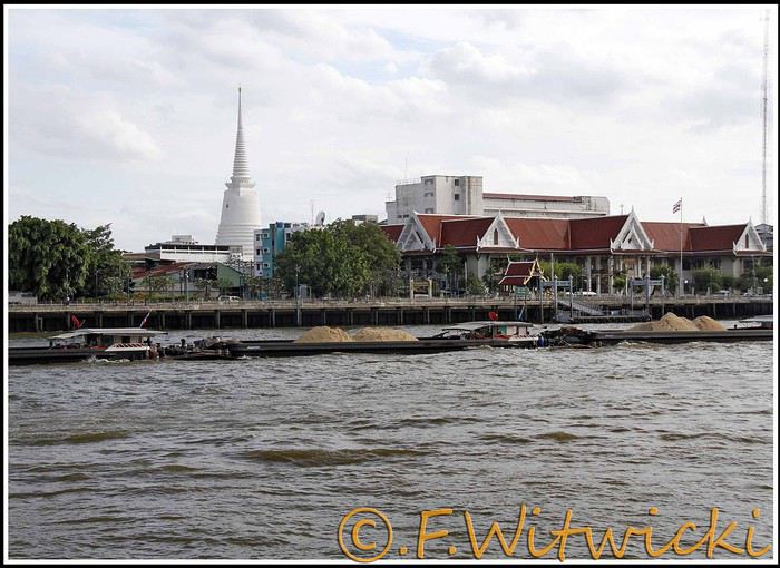
At that exact moment, the boat was packed. We didn’t see a ticket booth at the pier, and we tried in vain to pay the few baht for the ride. The cashier on the boat was too busy, and another employee we called didn’t have time to help us. Oh well, we weren’t going to force the issue. Still, this mode of transport is super practical for avoiding traffic, and at the piers, the lines with station names are clearly marked, with colors matching the flags on the boats. Combined with a map like the *Routard* guide, it’s easy to navigate.
We easily made it to the restaurant *Harmonique*, located near one of these piers. It’s a unanimous favorite on this forum, and let us tell you—it’s well-deserved. What a wonderful experience that evening! We only saw the outdoor gazebo because there was no way we were dining inside. It’s not flashy, so those looking for a luxurious setting should look elsewhere.
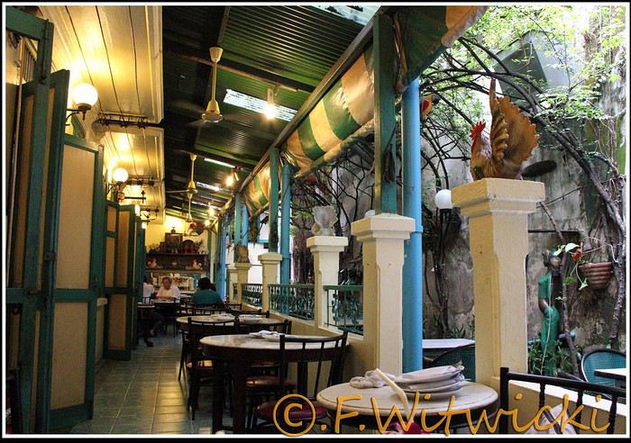
That night, the staff was a bit slow, and we had to track them down several times to move things along. But oh, my friends—what a feast on the plate! Start with the appetizer platter for two at 250 baht, featuring four specialties, each more tempting than the last, followed by their famous crab curry for 200 baht. There’s *so much* crab in there! The dish is so delicious and rich that when you finish, you feel—how to put it—like it was almost *too* good, to the point where you’re almost put off eating for days. And also, oh yes, we *will* be back. Their satay chicken is just as amazing, and it would be a crime not to mention their generous dessert with ice cream, warm banana, and chocolate, plus their *excellent* almond milkshake.
Later, we took a taxi to Kao San Road, mainly to book a Ko Tao-Chumphon trip for 600 baht per person at the Lomprayah counter. In hindsight, we should’ve booked all three of our trips there right away.
Kao San Road is *ultra*-touristy—better for younger crowds, but it’s still worth seeing. There’s rock ‘n’ roll, hippies, and crowds everywhere.
We walked back to the hotel, and when we got a little lost near a canal, a really nice older Thai man spontaneously appeared out of the night to kindly point us in the right direction.
Finally, a real long night of sleep ahead—we cranked up the AC. Sweet, the vacation has begun!
Our route was as follows: Bangkok, Siem Reap, Krabi, Suratthani, Koh Phangan, Koh Tao, Chumphon, Bang Saphan, Prachuab Khiri Khan, Sam Roi Yod, Hua Hin, Phetchaburi, Bangkok.
Beyond rediscovering Bangkok, our objectives were the long-held dream of seeing Angkor and exploring southern Thailand, much of which isn’t overly touristy.
A quick big thank-you to Barbot, who took the time to answer several of our questions.
12/07/2013
The cheapest flight we found earlier this year was a Paris-Bangkok route with a layover in Moscow for 1440 €, total for two people. So, this time we tried Aeroflot. Airbus A318 for the first leg, A330 for the second. Nothing particularly annoying to report—the passengers were very calm, the cabin temperature was comfortable, and we had enough legroom. That said, the quality of the meal trays was pretty mediocre, and the flight attendants weren’t exactly comedians.
We’d like to remind everyone that it’s best to exchange as little money as possible at the airport upon arrival, since the rate is about 5% worse than at city banks.
Of course, we made sure to take the airport exit where you can catch official taxis to avoid getting scammed. So, we queued up, a little lady gave us the ticket, and off we went with the driver. Generally, this system works well because these drivers are registered, know their duties, and the risks they face if they break the rules. Except that day, right off the bat, we got the scammer of the day. His first move was to snatch the ticket from my wife’s hands—the one you’re supposed to keep in case of a complaint. My husband saw it, but after a full day of travel, we were a bit out of it, and honestly, there was no reason to be suspicious. But once we started driving, the guy refused to turn on the meter. We insisted more and more firmly, but nothing. So, I used the famous method of opening the door and starting to step out of the car. At 40 km/h, that scares the driver more than the passenger. He finally turned on the meter, but that didn’t calm him down—quite the opposite. For the next half-hour, he ruined the ride by demanding extra fees here and there. Having dealt with several scam attempts last year in Vietnam, this wasn’t exactly new, and we were proud of ourselves for staying pretty zen. Still, this guy was a little scary—he was completely wired and aggressive. Honestly, it was hard not to think he was on something. He’d be perfect for a *Scarface* remake. When we finally arrived at the hotel, he followed us to the entrance. We paid the two tolls (25 and 45 baht), gave him the usual 100 baht extra for the ride, and stayed polite but firm. So, meter: 245 baht + 100 baht + 25 and 45 baht for tolls—we paid the exact amount, no way we were tipping this guy. He left furious, but he was already like that before picking us up... Anyway, avoid Mr. Chartree Chidchen, number 089 826 7308, car E2663!
We were so relieved to finally settle in at Feung Nakorn Balcony hotel in the temple district. 42 € per night, great reception, all the staff is friendly. The AC works fine, the bed seemed hard at first but turned out to be comfortable. The hotel is quiet, away from the nightlife, but at this time of year, many places are less crowded than in high season. Even with a nice fish pond and outdoor breakfast area, it’s a decent hotel, though we felt we could’ve found something better.
After a night on the plane, the first afternoon is always a bit of a slog. We napped for a few hours, and when we woke up—guess what—we were starving. We visited a temple across from the hotel (nothing special) and then decided to take the Chao Phraya Express, the river shuttle that serves many piers along the river. It was a really enjoyable experience. The steel gangway wobbles when you board and disembark, the boat sits low in the water, and sometimes you get splashed. During peak times, you’re packed in like sardines, but most of all, there’s that exotic urban landscape passing by, especially the temple rooftops.
At that exact moment, the boat was packed. We didn’t see a ticket booth at the pier, and we tried in vain to pay the few baht for the ride. The cashier on the boat was too busy, and another employee we called didn’t have time to help us. Oh well, we weren’t going to force the issue. Still, this mode of transport is super practical for avoiding traffic, and at the piers, the lines with station names are clearly marked, with colors matching the flags on the boats. Combined with a map like the *Routard* guide, it’s easy to navigate.
We easily made it to the restaurant *Harmonique*, located near one of these piers. It’s a unanimous favorite on this forum, and let us tell you—it’s well-deserved. What a wonderful experience that evening! We only saw the outdoor gazebo because there was no way we were dining inside. It’s not flashy, so those looking for a luxurious setting should look elsewhere.
That night, the staff was a bit slow, and we had to track them down several times to move things along. But oh, my friends—what a feast on the plate! Start with the appetizer platter for two at 250 baht, featuring four specialties, each more tempting than the last, followed by their famous crab curry for 200 baht. There’s *so much* crab in there! The dish is so delicious and rich that when you finish, you feel—how to put it—like it was almost *too* good, to the point where you’re almost put off eating for days. And also, oh yes, we *will* be back. Their satay chicken is just as amazing, and it would be a crime not to mention their generous dessert with ice cream, warm banana, and chocolate, plus their *excellent* almond milkshake.
Later, we took a taxi to Kao San Road, mainly to book a Ko Tao-Chumphon trip for 600 baht per person at the Lomprayah counter. In hindsight, we should’ve booked all three of our trips there right away.
Kao San Road is *ultra*-touristy—better for younger crowds, but it’s still worth seeing. There’s rock ‘n’ roll, hippies, and crowds everywhere.
We walked back to the hotel, and when we got a little lost near a canal, a really nice older Thai man spontaneously appeared out of the night to kindly point us in the right direction.
Finally, a real long night of sleep ahead—we cranked up the AC. Sweet, the vacation has begun!
Bonjour à tous,
sommes en discussion avec Bushtrackers-Africa en AFS pour louer un 4x4 équipé camping avec tente sur le toit. avez vous eu une expérience avec cette société ? les contacts par mail semblent être ok, mais comme nous avons vecu une déconvenue avec un loueur au Kenya, nous nous méfions un peu. avons également un devis de britz, que nous connaissons déjà.
merci de vos avis et conseils, bien cordialement, mimi
sommes en discussion avec Bushtrackers-Africa en AFS pour louer un 4x4 équipé camping avec tente sur le toit. avez vous eu une expérience avec cette société ? les contacts par mail semblent être ok, mais comme nous avons vecu une déconvenue avec un loueur au Kenya, nous nous méfions un peu. avons également un devis de britz, que nous connaissons déjà.
merci de vos avis et conseils, bien cordialement, mimi
Bon, voila je commence aujourd'hui ...
Tout ce que je sais c'est qu'il faut que je me fasse Hertz Gold pour ne pas perdre 3 plombes à l'aeroport ... et que je veux une bagnole américaine !
Tout ce que je sais c'est qu'il faut que je me fasse Hertz Gold pour ne pas perdre 3 plombes à l'aeroport ... et que je veux une bagnole américaine !
La compagnie aérienne low cost Ryanair a publié une étude selon laquelle 93% des passagers voyageront de nouveau à bord de ses avions, 95% pensant qu’elle propose un excellent rapport qualité-prix.
Dans un communiqué du 29 janvier 2013, la spécialiste irlandaise du vol pas cher précise que l’enquête du service clientèle a été effectuée auprès de 10 000 passagers à travers 28 pays d’Europe. Selon ses résultats, 93% des passagers voleront de nouveau avec Ryanair, 62% l’ont choisie pour ses tarifs bas et ont volé au moins quatre fois au cours des douze derniers mois. Le rapport qualité-prix de la low cost a été jugé excellent par 95% des passagers, 93% d’entre eux ont bénéficiés d’un vol à l’heure ; 87% expriment leur satisfaction globale et 84% confirment qu’ils recommanderaient Ryanair à un ami.
Pour le porte-parole Stephen McNamara, Ryanair accueillera « plus de 80 millions de passagers cette année en proposant les tarifs les plus bas et le meilleur service clientèle comprenant le plus de vols à l’heure, le moins de bagages égarés et le plus petit nombre d’annulation, ainsi que des tarifs bas et aucune surcharge carburant ».
La low cost, qui vient d’annoncer l’ouverture de ses deux premières bases hors d’Europe (au Maroc), a d’autre part revu à la hausse sa prévision de profit pour l’exercice 2012-2013 qui se termine en mars, à 540 millions d’euros contre 505 millions précédemment, en raison de la forte hausse des ventes de billets au dernier trimestre dans le nord de l’Europe.
An 80-Day Tour of Southern Africa
Back in South Africa
January 12, 2013, 5:30 AM, Flight BA043 London-Cape Town
Directly below, Windhoek glittered like a tangle of fairy lights still lit and tossed into a box.
The horizon, edged in purple, was setting up a backup fireworks display, and suddenly, like a cherry on the platter and with unbearable intensity, in less than two minutes the entire sun revealed a gray dam and then a vast, untouched massif.
A few more minutes and the glare to the east of the plane was total. In Africa, the sun is swift.
We still had a France to cross before landing, but it felt as if we were already there. To the west, the raking light revealed what looked like acne and long, swollen scars in a desert region that might be the Swartkloofberg. Further still, straight as far as the eye could see, the two parallel tracks of a dirt road.
At 11,500 meters altitude and 940 km/h, we had a sense of stillness until the Orange River appeared, an incongruous serpent, gray edged with green.
The first South African settlements were dotted with trees providing shade, then rivers highlighted by continuous lines of vegetation.
Water and shade that make life possible.
We’ll return here by the backroads.
Half an hour from Cape Town, the plane tilted toward the sea, crossing plantations (likely citrus) and then an explosion of cultivated greenery in circles on either side of an unruly river. Finally, the coastline was no longer just sand and water—a frothy hem, a suture?
A peninsula came into view, forming two magnificent bays, and... a flight attendant firmly instructed me to return to my seat: we’d arrived!
The Colors of Cape Town
The city was dressed up as I like them—deserted, fluid, free of its vendors.
In the parking lot of the endless beach next to the commercial port north of the city, about two hundred people were unloading their goods in front of their pickups or combis, none of which were from this century: mixed-race, ageless Black people, and white folks who looked like they’d stepped out of another era.
After a few minutes, intrigued, I played a game: first looking at the merchandise, then imagining who was selling it, and finally looking at who was actually manning the stall. Tall Black vendors were selling what they often sell in Europe—leather, sunglasses, watches; mixed-race folks offered discount bundles, and the tanned older white people seemed to have emptied their attics.
We left with an antique tin kettle for morning tea over an open fire, a pack of five exercise books (that’s 600 pages to fill), Bill Bryson’s earliest stories in English, some snoek rillettes (a local fish), and—never seen before—tuna biltong and snoek biltong.
In so-called advanced countries, Sunday is for sports: white cyclists dressed like pros sweating diligently, Black street vendors running in loops at red lights to sell trash bags that day; white golfers losing their balls, which a scantily clad Black man retrieves from the water; under the sails of kite surf boards, it’s all blondes, and in the foam, joyful splashes from a bunch of Black kids.
Searching for an unusual spot for lunch, we drove through the fishing port looking for a dive and, at the end of a dead-end road with no warning, we arrived at the Shimmy Beach Club—quite the program.
The place, open for just three weeks, aims to be ultra-trendy. You could be in San Francisco, Lisbon’s docks, or St. Barth. This time, the "visible" staff was diverse, but the clientele was exclusively white, except for one mixed-race couple.
For this Sunday lunch, the women had pulled out all the stops, and local starlets—who’d make ours look tame—were turning the terrace into a frenzy.
At Cape Town’s port, the girls have *port*. The trend seems to be crochet dresses over swimsuits.
For two hours, a team of employees watered and raked the sand, starting over when they finished. A child in a floaty pink dress and a gold headband, but a future adventurer, stepped onto the freshly raked artificial beach sand for the first time.
A lanky mixed-race man dragged a hose across the ground, followed by a white woman—enchanted?—who then started watering the sand herself, carelessly splashing the glass terrace her colleague had just swept. I suspect a tacit work arrangement to keep everyone employed.
A galleon packed with tourists (are there any in the hold? Does it take tourists to Robben Island?) left the port. A helicopter took off in its wake. Trawlers returned, cutting through a ballet of catamarans, their waterlines well above the water: a bad catch.
If there’s one country where you can’t pretend to ignore skin color, it’s this one. The question is in everyone’s mind, and here more than anywhere else, it’s a decisive economic and political factor.
Columbine of Brittany
200 km north of Cape Town and 9,000 km south of the Breton coast, but on the same cold ocean, we camped on the shore of the Columbine Cape Nature Reserve, sheltered by a rocky chaos that, at first light tomorrow, would transport us to Perros-Guirec.
Our first encounter with wild animals wouldn’t end well for them: it was crayfish season, and they were the size of lobsters at Lorient’s fish market. Bought for R60 (5.5 €) a pair from kids in Pater Noster, they’d end up between two rocks, over a fire. But first, we had to pair the Chenin blanc with some snoek biltong.
With no wood, I lit a fire at dawn with dried seaweed and kelp, as if petrified; it gave off a smell of court-bouillon and... tires. Two hundred fathoms away, on an outpost, an army of cormorants stood at attention, unmoved among the frolicking seals.
At the reserve’s exit, the guard spoke French; Patrick Mwanba had arrived from Congo three years earlier to study, but the cost of living here forced him to drop out. He’d like to return home because life is cheaper there, but the war made him hesitate.
Ding ding dong! Vroom! Arf arf, Woof! Buzz! (A night from hell!)
I’d long planned to visit Calvinia, the center of a region known for extensive sheep farming. An excellent provincial museum, run by an enthusiastic curator, kept us too late to start the drive north.
So we camped in a tiny, charming campsite set up in the garden of a house. A few trees, a patch of resilient grass, and a view of a pretty lit-up steeple—what else?
Well, it turned out to be a sound-and-light show, with the pretty steeple chiming the hours and half-hours. Then suddenly, we were in the VIP stands of the Karoo-Kalahari Truck Race: roaring trucks paraded under our canvas windows, and we realized we were on the main road through town. To top it off, we enjoyed an uninterrupted canine cacophony, from the *arf arf* of little dogs to the *woof* of a mastiff. Oh, and some mosquitoes—the first ones—insisted on keeping us company in the tent, and we hadn’t yet bought the arsenal to neutralize them.
I walked through Calvinia at night; the house gardens weren’t fenced, nor did they have the «Armed Response» signs so common in the country.
The Kalahari Trails
(No, no, I haven’t converted to hiking.)
North of Calvinia, in the south of the Northern Cape, small towns follow one another up to Upington, about a hundred kilometers apart—welcome havens. Between them, with no trees in sight, we stopped in the shade of a motionless cloud: the temperature exceeded 40°C in mid-January.
We were almost out of the High Karoo and into a region of pans drying up, until the first red dunes appeared, precursors of the Kalahari. In the sparse veld vegetation, gatherings of quiver trees in the kopjes, and a caravan of camels without a handler or packs, marching in perfect formation across a pan (no, I hadn’t overdone the Windhoek at the last stop, and no, I wasn’t dehydrated enough to hallucinate).
The historic part of these towns, European in style, was built on the same plans as those in the American Midwest or the Australian Outback: a grid of streets wide enough to turn a wagon pulled by eight pairs of oxen. The architecture was Dutch-inspired, tropicalized with awnings.
Then came more recent housing, functional in style, where the wealthier mixed-race people—who make up the majority of this state—lived, and further on, the township, an assemblage of corrugated iron and plastic, like everywhere else.
Orange, Right Bank
North of Augrabies Falls National Park, on the other side of the Orange River, stretches a rugged and wild territory the size of fifty Groix islands, crisscrossed by a few tracks—the Riemvasmaak.
The inhabitants were driven out half a century ago for a military base, and as soon as President Mandela was elected, he made it a symbol by allowing the exiled populations to return. Several ethnic groups live here on almost nothing, in government-built shacks.
A community camp is set up in a small cirque at the end of a canyon that, while not in the history books, offers a good descent. By mid-afternoon, the air was at 44°C, but luckily there was a spring... except it was a hot spring, with water at 38°C. And they haven’t invented a reversible spring yet. Once the birds and baboons had settled in, in absolute silence and far from any light pollution, we enjoyed the stars like nowhere else (well, that’s what they claim in the region).
The Orange didn’t choose the easy path: arriving from Lesotho, it was almost at the ocean. The terrain to the south and north of this massif seemed easier to cross. Was it to avoid the curse of the Okavango, whose waters disappear into the sands without ever seeing the sea, that it chose this rocky route, thinking that at least the granite wouldn’t steal its water?
I Love You, I Eat You
In the dry bed of the Auob, it lay panting, head raised, alert, between its paws but head-to-tail, a tawny springbok, motionless.
A few minutes earlier, their story had been written in a lightning-fast chase, captured in photos by the driver of the car that alerted us.
It would be a long time before it started eating at the groin without breaking its surveillance.
Earlier, there was a lion lounging in the shade and hundreds of antelopes: springboks and gemsboks (oryx) in herds, hartebeests and steenboks alone. Strange pairs, apart several times, formed by a springbok and a gemsbok.
A few solitary jackals moved slightly sideways, looking furtive. Ostriches, alone, looking a bit dazed.
It was a lucky morning in the Kgalagadi (KTP).
In and Out
Kgalagadi, Nossob Camp.
We were at the very end of the almost-empty camp, ten meters from the fence, whose structure wouldn’t resist an elephant (though there aren’t any here), but it was electrified.
At dusk, on the other side, ten meters away, three lions passed in a row, as if on parade, seemingly focused on their goal and indifferent to the camp, though they glanced at it.
A jackal had gotten into the camp and was trying to get out without success while scavenging. I offered it two pieces of snoek biltong (Don’t feed the animals!) from three meters away—it smelled strong and had bones (bones in biltong!). When it passed by again, it sniffed but didn’t dare approach. Curled up in the chair, motionless, by the faint moonlight, I finally saw it come closer, grab the nearest piece, and move ten meters away to enjoy it (how many jackals know the finer points of sea biltong?). A little reassured, it came back for the second piece.
Another Morning
By morning, the jackal was gone, but our luck hadn’t left us. Two cheetahs again, who found me in the way and slowly moved toward a calmer shadow. Enough birds of prey to form a squadron, but they’re solitary hunters. Two ostriches busy with their dozen unruly chicks. And while we’re at it, a group of four Kalahari lions, sprawled under a thorny bush. Lots of oryx crossing the dunes and herds of red hartebeest. Kori bustards and secretary birds.
It was the first time the Kgalagadi had spoiled us so much.
Back in South Africa
January 12, 2013, 5:30 AM, Flight BA043 London-Cape Town
Directly below, Windhoek glittered like a tangle of fairy lights still lit and tossed into a box.
The horizon, edged in purple, was setting up a backup fireworks display, and suddenly, like a cherry on the platter and with unbearable intensity, in less than two minutes the entire sun revealed a gray dam and then a vast, untouched massif.
A few more minutes and the glare to the east of the plane was total. In Africa, the sun is swift.
We still had a France to cross before landing, but it felt as if we were already there. To the west, the raking light revealed what looked like acne and long, swollen scars in a desert region that might be the Swartkloofberg. Further still, straight as far as the eye could see, the two parallel tracks of a dirt road.
At 11,500 meters altitude and 940 km/h, we had a sense of stillness until the Orange River appeared, an incongruous serpent, gray edged with green.
The first South African settlements were dotted with trees providing shade, then rivers highlighted by continuous lines of vegetation.
Water and shade that make life possible.
We’ll return here by the backroads.
Half an hour from Cape Town, the plane tilted toward the sea, crossing plantations (likely citrus) and then an explosion of cultivated greenery in circles on either side of an unruly river. Finally, the coastline was no longer just sand and water—a frothy hem, a suture?
A peninsula came into view, forming two magnificent bays, and... a flight attendant firmly instructed me to return to my seat: we’d arrived!
The Colors of Cape Town
The city was dressed up as I like them—deserted, fluid, free of its vendors.
In the parking lot of the endless beach next to the commercial port north of the city, about two hundred people were unloading their goods in front of their pickups or combis, none of which were from this century: mixed-race, ageless Black people, and white folks who looked like they’d stepped out of another era.
After a few minutes, intrigued, I played a game: first looking at the merchandise, then imagining who was selling it, and finally looking at who was actually manning the stall. Tall Black vendors were selling what they often sell in Europe—leather, sunglasses, watches; mixed-race folks offered discount bundles, and the tanned older white people seemed to have emptied their attics.
We left with an antique tin kettle for morning tea over an open fire, a pack of five exercise books (that’s 600 pages to fill), Bill Bryson’s earliest stories in English, some snoek rillettes (a local fish), and—never seen before—tuna biltong and snoek biltong.
In so-called advanced countries, Sunday is for sports: white cyclists dressed like pros sweating diligently, Black street vendors running in loops at red lights to sell trash bags that day; white golfers losing their balls, which a scantily clad Black man retrieves from the water; under the sails of kite surf boards, it’s all blondes, and in the foam, joyful splashes from a bunch of Black kids.
Searching for an unusual spot for lunch, we drove through the fishing port looking for a dive and, at the end of a dead-end road with no warning, we arrived at the Shimmy Beach Club—quite the program.
The place, open for just three weeks, aims to be ultra-trendy. You could be in San Francisco, Lisbon’s docks, or St. Barth. This time, the "visible" staff was diverse, but the clientele was exclusively white, except for one mixed-race couple.
For this Sunday lunch, the women had pulled out all the stops, and local starlets—who’d make ours look tame—were turning the terrace into a frenzy.
At Cape Town’s port, the girls have *port*. The trend seems to be crochet dresses over swimsuits.
For two hours, a team of employees watered and raked the sand, starting over when they finished. A child in a floaty pink dress and a gold headband, but a future adventurer, stepped onto the freshly raked artificial beach sand for the first time.
A lanky mixed-race man dragged a hose across the ground, followed by a white woman—enchanted?—who then started watering the sand herself, carelessly splashing the glass terrace her colleague had just swept. I suspect a tacit work arrangement to keep everyone employed.
A galleon packed with tourists (are there any in the hold? Does it take tourists to Robben Island?) left the port. A helicopter took off in its wake. Trawlers returned, cutting through a ballet of catamarans, their waterlines well above the water: a bad catch.
If there’s one country where you can’t pretend to ignore skin color, it’s this one. The question is in everyone’s mind, and here more than anywhere else, it’s a decisive economic and political factor.
Columbine of Brittany
200 km north of Cape Town and 9,000 km south of the Breton coast, but on the same cold ocean, we camped on the shore of the Columbine Cape Nature Reserve, sheltered by a rocky chaos that, at first light tomorrow, would transport us to Perros-Guirec.
Our first encounter with wild animals wouldn’t end well for them: it was crayfish season, and they were the size of lobsters at Lorient’s fish market. Bought for R60 (5.5 €) a pair from kids in Pater Noster, they’d end up between two rocks, over a fire. But first, we had to pair the Chenin blanc with some snoek biltong.
With no wood, I lit a fire at dawn with dried seaweed and kelp, as if petrified; it gave off a smell of court-bouillon and... tires. Two hundred fathoms away, on an outpost, an army of cormorants stood at attention, unmoved among the frolicking seals.
At the reserve’s exit, the guard spoke French; Patrick Mwanba had arrived from Congo three years earlier to study, but the cost of living here forced him to drop out. He’d like to return home because life is cheaper there, but the war made him hesitate.
Ding ding dong! Vroom! Arf arf, Woof! Buzz! (A night from hell!)
I’d long planned to visit Calvinia, the center of a region known for extensive sheep farming. An excellent provincial museum, run by an enthusiastic curator, kept us too late to start the drive north.
So we camped in a tiny, charming campsite set up in the garden of a house. A few trees, a patch of resilient grass, and a view of a pretty lit-up steeple—what else?
Well, it turned out to be a sound-and-light show, with the pretty steeple chiming the hours and half-hours. Then suddenly, we were in the VIP stands of the Karoo-Kalahari Truck Race: roaring trucks paraded under our canvas windows, and we realized we were on the main road through town. To top it off, we enjoyed an uninterrupted canine cacophony, from the *arf arf* of little dogs to the *woof* of a mastiff. Oh, and some mosquitoes—the first ones—insisted on keeping us company in the tent, and we hadn’t yet bought the arsenal to neutralize them.
I walked through Calvinia at night; the house gardens weren’t fenced, nor did they have the «Armed Response» signs so common in the country.
The Kalahari Trails
(No, no, I haven’t converted to hiking.)
North of Calvinia, in the south of the Northern Cape, small towns follow one another up to Upington, about a hundred kilometers apart—welcome havens. Between them, with no trees in sight, we stopped in the shade of a motionless cloud: the temperature exceeded 40°C in mid-January.
We were almost out of the High Karoo and into a region of pans drying up, until the first red dunes appeared, precursors of the Kalahari. In the sparse veld vegetation, gatherings of quiver trees in the kopjes, and a caravan of camels without a handler or packs, marching in perfect formation across a pan (no, I hadn’t overdone the Windhoek at the last stop, and no, I wasn’t dehydrated enough to hallucinate).
The historic part of these towns, European in style, was built on the same plans as those in the American Midwest or the Australian Outback: a grid of streets wide enough to turn a wagon pulled by eight pairs of oxen. The architecture was Dutch-inspired, tropicalized with awnings.
Then came more recent housing, functional in style, where the wealthier mixed-race people—who make up the majority of this state—lived, and further on, the township, an assemblage of corrugated iron and plastic, like everywhere else.
Orange, Right Bank
North of Augrabies Falls National Park, on the other side of the Orange River, stretches a rugged and wild territory the size of fifty Groix islands, crisscrossed by a few tracks—the Riemvasmaak.
The inhabitants were driven out half a century ago for a military base, and as soon as President Mandela was elected, he made it a symbol by allowing the exiled populations to return. Several ethnic groups live here on almost nothing, in government-built shacks.
A community camp is set up in a small cirque at the end of a canyon that, while not in the history books, offers a good descent. By mid-afternoon, the air was at 44°C, but luckily there was a spring... except it was a hot spring, with water at 38°C. And they haven’t invented a reversible spring yet. Once the birds and baboons had settled in, in absolute silence and far from any light pollution, we enjoyed the stars like nowhere else (well, that’s what they claim in the region).
The Orange didn’t choose the easy path: arriving from Lesotho, it was almost at the ocean. The terrain to the south and north of this massif seemed easier to cross. Was it to avoid the curse of the Okavango, whose waters disappear into the sands without ever seeing the sea, that it chose this rocky route, thinking that at least the granite wouldn’t steal its water?
I Love You, I Eat You
In the dry bed of the Auob, it lay panting, head raised, alert, between its paws but head-to-tail, a tawny springbok, motionless.
A few minutes earlier, their story had been written in a lightning-fast chase, captured in photos by the driver of the car that alerted us.
It would be a long time before it started eating at the groin without breaking its surveillance.
Earlier, there was a lion lounging in the shade and hundreds of antelopes: springboks and gemsboks (oryx) in herds, hartebeests and steenboks alone. Strange pairs, apart several times, formed by a springbok and a gemsbok.
A few solitary jackals moved slightly sideways, looking furtive. Ostriches, alone, looking a bit dazed.
It was a lucky morning in the Kgalagadi (KTP).
In and Out
Kgalagadi, Nossob Camp.
We were at the very end of the almost-empty camp, ten meters from the fence, whose structure wouldn’t resist an elephant (though there aren’t any here), but it was electrified.
At dusk, on the other side, ten meters away, three lions passed in a row, as if on parade, seemingly focused on their goal and indifferent to the camp, though they glanced at it.
A jackal had gotten into the camp and was trying to get out without success while scavenging. I offered it two pieces of snoek biltong (Don’t feed the animals!) from three meters away—it smelled strong and had bones (bones in biltong!). When it passed by again, it sniffed but didn’t dare approach. Curled up in the chair, motionless, by the faint moonlight, I finally saw it come closer, grab the nearest piece, and move ten meters away to enjoy it (how many jackals know the finer points of sea biltong?). A little reassured, it came back for the second piece.
Another Morning
By morning, the jackal was gone, but our luck hadn’t left us. Two cheetahs again, who found me in the way and slowly moved toward a calmer shadow. Enough birds of prey to form a squadron, but they’re solitary hunters. Two ostriches busy with their dozen unruly chicks. And while we’re at it, a group of four Kalahari lions, sprawled under a thorny bush. Lots of oryx crossing the dunes and herds of red hartebeest. Kori bustards and secretary birds.
It was the first time the Kgalagadi had spoiled us so much.
Je suis ravie de vous retrouver pour ce nouveau concours photos. Au cours du mois, je partirai quelques jours en voyage. Aussi, Tafakara (Je l'en remercie) sera mon binôme pour suivre la discussion et comptabiliser les votes pour désigner le gagnant. Grâce à l'aide de Kistal, nous aurons à disposition un diaporama présentant les photos.🙂
Bonjour aux braves!
Il y a trois mois, j’ai commencé un poste intitulé Peuples de la Chine et de l'Asie du Sud-Est, dont voici le lien ci-dessous :
http://voyageforum.com/...ie_sud_est_D2833480/
Ce poste a gagné une certaine popularité et a maintenant dépassé 500 messages. L’équipe de VF m’a donc demandé de le clore parce que cela n’est plus gérable au point de vue informatique. Sur quoi a porté cette longue discussion qui a fait monter l’aiguille du serveur VF dans le rouge ?
Nous avons tout d’abord passé l’histoire de la Chine en revue, car elle a conditionné en très grande mesure les mouvements de populations de la Chine du Sud vers l’Asie du Sud-Est, et au-delà. Nous avons beaucoup parlé des pressions répétées sur la Chine par divers peuples évoluant au-delà de ses frontières septentrionales, des migrations Malayo-Polynésiennes issues de Taiwan et plus loin dans le temps de la Chine du Sud, des Hmong-Mien, des Khmer etc…. En route, j’ai tenu à introduire des explications concernant les familles linguistiques de ces peuples et leurs filiations génétiques. Nous en étions arrivés aux Thaï.
J’ai beaucoup apprécié les contributions d’un petit groupe de lecteurs que je remercie chaudement pour leur fidélité et la qualité de leurs interventions. À vrai dire, je pense avoir largement couvert le sujet que je m’étais donné au départ et je pourrais m’arrêter là. Cependant, il me reste quelques « fils à remonter », qui probablement ne demanderont pas une autre discussion de 500 messages, mais sait-on jamais ?
Voici donc la suite.
Il y a trois mois, j’ai commencé un poste intitulé Peuples de la Chine et de l'Asie du Sud-Est, dont voici le lien ci-dessous :
http://voyageforum.com/...ie_sud_est_D2833480/
Ce poste a gagné une certaine popularité et a maintenant dépassé 500 messages. L’équipe de VF m’a donc demandé de le clore parce que cela n’est plus gérable au point de vue informatique. Sur quoi a porté cette longue discussion qui a fait monter l’aiguille du serveur VF dans le rouge ?
Nous avons tout d’abord passé l’histoire de la Chine en revue, car elle a conditionné en très grande mesure les mouvements de populations de la Chine du Sud vers l’Asie du Sud-Est, et au-delà. Nous avons beaucoup parlé des pressions répétées sur la Chine par divers peuples évoluant au-delà de ses frontières septentrionales, des migrations Malayo-Polynésiennes issues de Taiwan et plus loin dans le temps de la Chine du Sud, des Hmong-Mien, des Khmer etc…. En route, j’ai tenu à introduire des explications concernant les familles linguistiques de ces peuples et leurs filiations génétiques. Nous en étions arrivés aux Thaï.
J’ai beaucoup apprécié les contributions d’un petit groupe de lecteurs que je remercie chaudement pour leur fidélité et la qualité de leurs interventions. À vrai dire, je pense avoir largement couvert le sujet que je m’étais donné au départ et je pourrais m’arrêter là. Cependant, il me reste quelques « fils à remonter », qui probablement ne demanderont pas une autre discussion de 500 messages, mais sait-on jamais ?
Voici donc la suite.